SUSTAINABILITY
UC30G
UC30G

Create successful ePaper yourself
Turn your PDF publications into a flip-book with our unique Google optimized e-Paper software.
FEATURES<br />
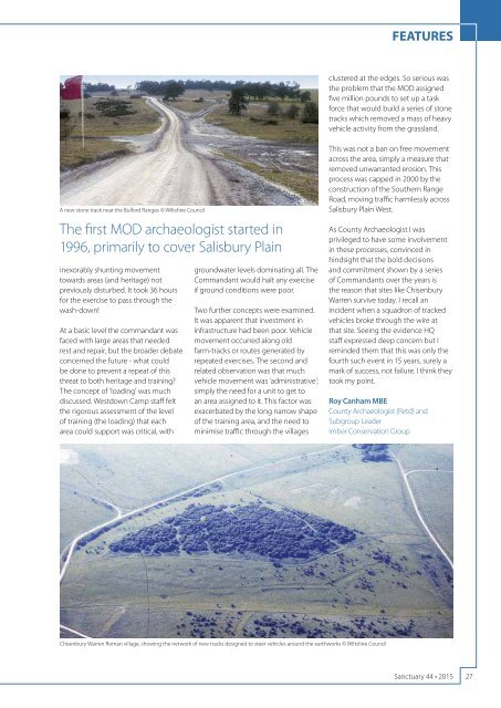
clustered at the edges. So serious was<br />
the problem that the MOD assigned<br />
five million pounds to set up a task<br />
force that would build a series of stone<br />
tracks which removed a mass of heavy<br />
vehicle activity from the grassland.<br />
A new stone track near the Bulford Ranges © Wiltshire Council<br />
The first MOD archaeologist started in<br />
1996, primarily to cover Salisbury Plain<br />
inexorably shunting movement<br />
towards areas (and heritage) not<br />
previously disturbed. It took 36 hours<br />
for the exercise to pass through the<br />
wash-down!<br />
At a basic level the commandant was<br />
faced with large areas that needed<br />
rest and repair, but the broader debate<br />
concerned the future - what could<br />
be done to prevent a repeat of this<br />
threat to both heritage and training?<br />
The concept of ‘loading’ was much<br />
discussed. Westdown Camp staff felt<br />
the rigorous assessment of the level<br />
of training (the loading) that each<br />
area could support was critical, with<br />
groundwater levels dominating all. The<br />
Commandant would halt any exercise<br />
if ground conditions were poor.<br />
Two further concepts were examined.<br />
It was apparent that investment in<br />
infrastructure had been poor. Vehicle<br />
movement occurred along old<br />
farm-tracks or routes generated by<br />
repeated exercises. The second and<br />
related observation was that much<br />
vehicle movement was ‘administrative’;<br />
simply the need for a unit to get to<br />
an area assigned to it. This factor was<br />
exacerbated by the long narrow shape<br />
of the training area, and the need to<br />
minimise traffc through the villages<br />
This was not a ban on free movement<br />
across the area, simply a measure that<br />
removed unwarranted erosion. This<br />
process was capped in 2000 by the<br />
construction of the Southern Range<br />
Road, moving traffc harmlessly across<br />
Salisbury Plain West.<br />
As County Archaeologist I was<br />
privileged to have some involvement<br />
in these processes, convinced in<br />
hindsight that the bold decisions<br />
and commitment shown by a series<br />
of Commandants over the years is<br />
the reason that sites like Chisenbury<br />
Warren survive today. I recall an<br />
incident when a squadron of tracked<br />
vehicles broke through the wire at<br />
that site. Seeing the evidence HQ<br />
staff expressed deep concern but I<br />
reminded them that this was only the<br />
fourth such event in 15 years, surely a<br />
mark of success, not failure. I think they<br />
took my point.<br />
Roy Canham MBE<br />
County Archaeologist (Retd) and<br />
Subgroup Leader<br />
Imber Conservation Group<br />
Chisenbury Warren Roman village, showing the network of new tracks designed to steer vehicles around the earthworks © Wiltshire Council<br />
Sanctuary 44 • 2015<br />
27