

Lake Melville
1rw7Mns
1rw7Mns

Create successful ePaper yourself
Turn your PDF publications into a flip-book with our unique Google optimized e-Paper software.
65°W<br />
64°W<br />
63°W<br />
62°W<br />
61°W<br />
60°W<br />
Upper Churchill River Watershed<br />
Lower Churchill River Watershed<br />
Lower Churchill Hydroelectric<br />
Project Aquatic Assessment Area<br />
Smallwood Reservoir<br />
54°N 54°N<br />
<strong>Lake</strong> <strong>Melville</strong><br />
Muskrat<br />
53°N Falls<br />
53°N<br />
Gull<br />
Island<br />
0 25 50 100 150 200<br />
Kilometres<br />
52°N 52°N<br />
65°W<br />
64°W<br />
63°W<br />
62°W<br />
61°W<br />
60°W<br />
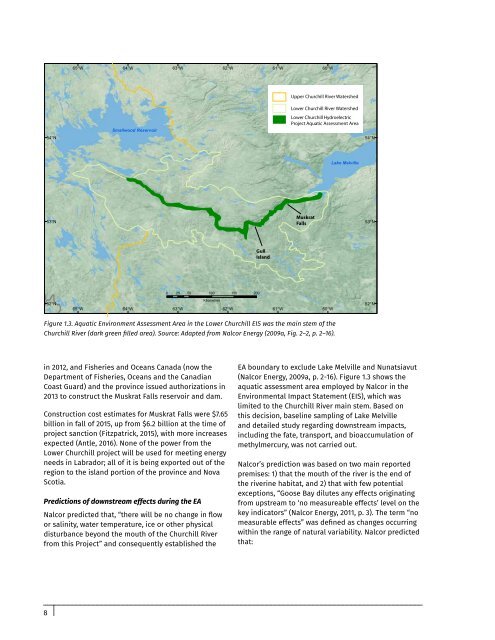
Figure 1.3. Aquatic Environment Assessment Area in the Lower Churchill EIS was the main stem of the<br />
Churchill River (dark green filled area). Source: Adapted from Nalcor Energy (2009a, Fig. 2–2, p. 2–16).<br />
in 2012, and Fisheries and Oceans Canada (now the<br />
Department of Fisheries, Oceans and the Canadian<br />
Coast Guard) and the province issued authorizations in<br />
2013 to construct the Muskrat Falls reservoir and dam.<br />
Construction cost estimates for Muskrat Falls were $7.65<br />
billion in fall of 2015, up from $6.2 billion at the time of<br />
project sanction (Fitzpatrick, 2015), with more increases<br />
expected (Antle, 2016). None of the power from the<br />
Lower Churchill project will be used for meeting energy<br />
needs in Labrador; all of it is being exported out of the<br />
region to the island portion of the province and Nova<br />
Scotia.<br />
Predictions of downstream effects during the EA<br />
Nalcor predicted that, “there will be no change in flow<br />
or salinity, water temperature, ice or other physical<br />
disturbance beyond the mouth of the Churchill River<br />
from this Project” and consequently established the<br />
EA boundary to exclude <strong>Lake</strong> <strong>Melville</strong> and Nunatsiavut<br />
(Nalcor Energy, 2009a, p. 2-16). Figure 1.3 shows the<br />
aquatic assessment area employed by Nalcor in the<br />
Environmental Impact Statement (EIS), which was<br />
limited to the Churchill River main stem. Based on<br />
this decision, baseline sampling of <strong>Lake</strong> <strong>Melville</strong><br />
and detailed study regarding downstream impacts,<br />
including the fate, transport, and bioaccumulation of<br />
methylmercury, was not carried out.<br />
Nalcor’s prediction was based on two main reported<br />
premises: 1) that the mouth of the river is the end of<br />
the riverine habitat, and 2) that with few potential<br />
exceptions, “Goose Bay dilutes any effects originating<br />
from upstream to ‘no measureable effects’ level on the<br />
key indicators” (Nalcor Energy, 2011, p. 3). The term “no<br />
measurable effects” was defined as changes occurring<br />
within the range of natural variability. Nalcor predicted<br />
that:<br />
8