

Reviewing the Plan for Solihull’s Future
Draft_Local_Plan_05.12.16
Draft_Local_Plan_05.12.16

You also want an ePaper? Increase the reach of your titles
YUMPU automatically turns print PDFs into web optimized ePapers that Google loves.
<strong>Reviewing</strong> <strong>the</strong> <strong>Plan</strong> <strong>for</strong> <strong>Solihull’s</strong> <strong>Future</strong><br />
Draft Local <strong>Plan</strong><br />
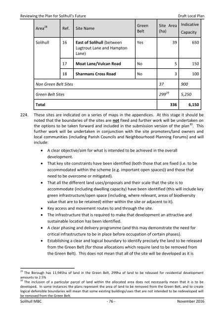
Area 28 Ref. Site Name<br />
Green<br />
Belt<br />
Site Area<br />
(ha)<br />
Indicative<br />
Capacity<br />
Solihull 16 East of Solihull (between<br />
Lugtrout Lane and Hampton<br />
Lane)<br />
Yes 39 650<br />
17 Moat Lane/Vulcan Road No 5 150<br />
18 Sharmans Cross Road No 3 100<br />
Non Green Belt Sites 37 900<br />
Green Belt Sites 299 29 5,250<br />
Total 336 6,150<br />
224. These sites are indicated on a series of maps in <strong>the</strong> appendices. At this stage it should be<br />
noted that <strong>the</strong> boundaries of <strong>the</strong> sites are not fixed and fur<strong>the</strong>r work will be undertaken on<br />
<strong>the</strong> options to be taken <strong>for</strong>ward and included in <strong>the</strong> submission version of <strong>the</strong> plan 30 . This<br />
fur<strong>the</strong>r work will be undertaken in conjunction with <strong>the</strong> site promoters/land owners and<br />
local communities (including Parish Councils and Neighbourhood <strong>Plan</strong>ning Forums) and will<br />
include:<br />
<br />
<br />
<br />
<br />
<br />
<br />
<br />
A clear objective/aim <strong>for</strong> what is intended to be achieved in <strong>the</strong> overall<br />
development.<br />
That key site constraints have been identified (both those that are fixed (i.e. to be<br />
accommodated within <strong>the</strong> scheme (e.g. important open spaces)) and those that<br />
need to be overcome or mitigated).<br />
That all <strong>the</strong> different land uses/proposals and <strong>the</strong>ir scale that <strong>the</strong> site is to<br />
accommodate (including dwelling capacity) have been identified (this will include key<br />
green infrastructure/open space (including, where relevant, areas of biodiversity<br />
value that are to be retained) ei<strong>the</strong>r within <strong>the</strong> site or adjacent to it).<br />
Key access and movement routes to and through <strong>the</strong> site.<br />
The infrastructure that is required to make that development an attractive and<br />
sustainable location has been identified.<br />
A clear phasing and delivery programme (and this may demonstrate <strong>the</strong> need <strong>for</strong><br />
critical infrastructure to be in place be<strong>for</strong>e occupation of certain phases).<br />
Establishing a clear and logical boundary to identify precisely <strong>the</strong> land to be released<br />
from <strong>the</strong> Green Belt (<strong>for</strong> those allocations which require land to be removed from<br />
<strong>the</strong> Green Belt). This does not mean that all of <strong>the</strong> site will be developed as it is<br />
29 The Borough has 11,945ha of land in <strong>the</strong> Green Belt, 299ha of land to be released <strong>for</strong> residential development<br />
amounts to 2.5%<br />
30 The inclusion of a particular parcel of land within <strong>the</strong> allocated area does not necessarily mean that it is to be<br />
developed. In some instances <strong>the</strong> plans represent <strong>the</strong> area of land to be removed from <strong>the</strong> Green Belt, and to create<br />
logical defensible boundaries will mean that some existing buildings/uses that are not intended to be redeveloped will<br />
be removed from <strong>the</strong> Green Belt.<br />
Solihull MBC - 76 - November 2016