You also want an ePaper? Increase the reach of your titles
YUMPU automatically turns print PDFs into web optimized ePapers that Google loves.
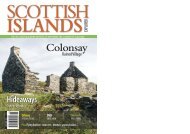
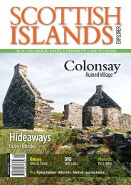
Colonsay’s Ruined Village<br />
Colonsay’s<br />
Ruined Village<br />
Roger Butler explores the ruins at Riasg Buidhe<br />
The ferry is nosing along the east coast of Colonsay and excited travellers peer through<br />
binoculars at the rugged coastline and a knobbly horizon of hills. The pier at Scalasaig<br />
sneaks into view and the pontoons around the new fish farm wobble in the waves. A heron rises<br />
lazily from the shore as a seasoned visitor grabs someone by the shoulder and points to a wedge of<br />
rising moorland.<br />
It takes a moment or two to spot the row of small roofless houses which effortlessly merge into<br />
the heath and the heather. This is the ruined village of Riasg Buidhe and the view from the ferry<br />
shows how its former inhabitants were quite isolated from other parts of the island. Their walls<br />
and gables, now empty for almost a hundred years, are slowly merging back into the bracken.<br />
Passengers have already started to make their way towards the car deck as the line of houses at<br />
Glassard, on the north side of the harbour, comes into view. There have been some recent additions<br />
here, but the original pebble-dashed properties were built to re-house the people of Riasg Buidhe<br />
(pronounced ‘risk-booee’) after the First World War. The ferry groans as it manoeuvres towards<br />
the pier, but the ruined village has now completely disappeared behind a long low headland.<br />
‘Riasg Buidhe includes the remains of a chapel,<br />
which may indicate that an earlier settlement<br />
pre-dates the row of houses.’<br />
270 Million Years<br />
The walk from Scalasaig to Riasg Buidhe passes the houses at Glassard, wriggles across half a mile<br />
of moor and drops towards patches of salty marshland with views to the Paps of Jura. A black dyke,<br />
interspersed with sparkly crystals and dating back 270 million years to the Permian period, runs<br />
along the north side of Port a’ Bhàta, which was the landing place for the old village.<br />
The people of Riasg Buidhe were fisherfolk and, during the week, the men would hole-up in one<br />
of the big caves on the west coast of Jura, possibly near Ruantallain by the northern entrance to<br />
Loch Tarbert. They would return with their catch, under sail or using oars if necessary, though<br />
these trips came to end with the outbreak of war and by the 1920s the inshore fishing had all but<br />
ceased. Yet until the 1970s, the remains of old fishing equipment could be found in a crevice above<br />
the tideline.<br />
Several decades ago, an islander was able to recall: ‘On Sunday you would have thought these men<br />
came out of a mansion. Every one of them had a blue suit, with the trousers beautifully creased, and<br />
even though they had walked across the rough ground to get to the church there was never a mark<br />
on their clothes. Then, when the service was over, they would walk home and away would go the<br />
blue suit, back into the chest until next Sunday. They would then put on their navy blue jerseys<br />
once again, which were almost a uniform amongst them’.<br />
16 SCOTTISH ISLANDS EXPLORER MAY / JUNE <strong>2017</strong>