Singletrack

Create successful ePaper yourself
Turn your PDF publications into a flip-book with our unique Google optimized e-Paper software.
A short descent east and a left fork led to Curraghard<br />
viewpoint, where jagged stone chairs provided us with a seated<br />
view over Newcastle town to the coast beyond. At this point<br />
you can observe the rest of the route stretching round the<br />
coastline with a first decent view of the rounded summit of<br />
Slieve Donard, at 853m, Northern Ireland’s most elevated<br />
point, high up on the right.<br />
The drop from here has bite, a steep entry line funnelling<br />
into numerous rock drops and tight twists, spiky bushes<br />
and trees on hand to punish wayward lines. The other lads<br />
afforded it little respect, but I was extremely careful – pain<br />
of pride far overridden by real twinges as I watched them<br />
tear out of sight. Briefly revisiting the main track, we then<br />
ducked into a hole on the right where a change in foliage<br />
type and a needle-floored delight took us to the crossing<br />
point of the figure of eight route. Following the Mourne Way<br />
signposts down a grassy section, we ultimately joined the road<br />
at Tullybrannigan – clearly the very affluent end of town.<br />
Spinning down through Tipperary Wood towards Donard car<br />
park, food was at the forefront of our minds and coffee and<br />
scones were hoovered as we awaited Chris’ arrival from the<br />
comfort of Niki’s cafe.<br />
In his defence, I had warned him to be brightly attired<br />
for the cameras but we were shocked and amused by the giant<br />
jelly baby that emerged from the van. None too subtle ribbing<br />
completed, we ascended again into Donard Forest, opting<br />
for a tricky short cut alongside the Glen River, rather than<br />
the winding forestry access track. This next section was cause<br />
for genuine trepidation as the grassed trail up to Drinneevar<br />
quarry has gained infamy as the site of several recent buzzard<br />
attacks resulting in hospitalisations, temporary closures and<br />
even the rerouting of a well-established fell race. A warning<br />
sign and a pile of pigeon feathers served as a stark reminder<br />
that the danger is very real and a comedy of style commenced.<br />
Steep trails of this ilk are hard enough on which to maintain<br />
traction and forward motion, but doing so while craning your<br />
head backwards and scanning the sky is a near impossibility.<br />
We all eventually succumbed to the inevitable and pushed the<br />
last 50m, gathered together for safety in numbers and hoping<br />
our loud conversation wouldn’t pique the interest of the<br />
lurking raptor.<br />
Raptor-free.<br />
Departing the quarry trail and heading over the shoulder,<br />
we were treated to another expansive view of mountain and<br />
coast. I can think of few places where such pronounced hills<br />
are in this proximity to the sea; it really is a sight to behold,<br />
even through the increasing late-afternoon haze. Remarking<br />
that the gorse has really grown up since last at this spot, we<br />
were treated to a demonstration of instant karma befalling<br />
Eddie. This open mountain trail is almost trials-like in<br />
nature, allowing slow speed proximity riding and the luxury<br />
of conversation. Eddie was regaling us with the tale of his<br />
girlfriend falling into a gorse bush while he just stood and<br />
laughed when the rightful inevitability occurred.<br />
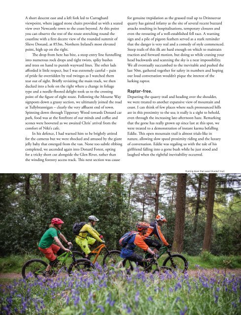
Hunting down that sweet bluebell trail.<br />
73