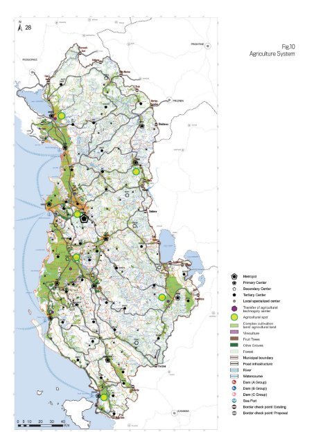
28 Fig.10 Agriculture System
29 The policies supported by the <str<strong>on</strong>g>Nati<strong>on</strong>al</str<strong>on</strong>g> Plan <strong>in</strong> this regard are: 1. Preservati<strong>on</strong> 2. C<strong>on</strong>solidati<strong>on</strong> 3. Modernizati<strong>on</strong> energy, impact of the water system due to climate changes. Policies of urban development densificati<strong>on</strong> and natural corridors al<strong>on</strong>g river valleys are the primary policies, which the <str<strong>on</strong>g>Nati<strong>on</strong>al</str<strong>on</strong>g> Plan br<strong>in</strong>gs <strong>in</strong> support of this system. The NSP marks the blue l<strong>in</strong>e for the protecti<strong>on</strong> of water sources from prohibited uses and private use. ʧ 200 m distance from the maritime shorel<strong>in</strong>e and at the same time, 2 m izoipsos for the flat seashore, and 60 m izoipsos for the rocky coast. ʧ 100 m distance from the river shore for river flows, prohibiti<strong>on</strong> of every activity, and the 1 km belt of natural corridors associat<strong>in</strong>g their flow is ma<strong>in</strong>ta<strong>in</strong>ed <strong>on</strong>ly for use with nature as priority. ʧ Protecti<strong>on</strong> of the Vjosa Catchment Bas<strong>in</strong>, declar<strong>in</strong>g it an Area of Protected Landscape. Vjosa is dist<strong>in</strong>guished from other rivers <strong>in</strong> the Balkans for the high level of water potential, geological c<strong>on</strong>structi<strong>on</strong> of the formati<strong>on</strong>s al<strong>on</strong>g it, and the diversity of landscapes across the valley. ʧ Demands for the safe supply of <strong>in</strong>habited settlements is closely l<strong>in</strong>ked to the technical requirements of water supply <strong>in</strong>frastructure. In this regard, the document <strong>in</strong>troduces some of the legal requirements to be taken <strong>in</strong>to account when draft<strong>in</strong>g territorial plans for safer potable water supply. ʧ Furthermore, the NSP document <strong>in</strong>troduces the risks and proposes measures for the protecti<strong>on</strong> and adapti<strong>on</strong> of the climate changes, especially for the water system. 1.11 Agricultural System Agriculture has traditi<strong>on</strong>ally been <strong>on</strong>e of the important branches of ec<strong>on</strong>omic development <strong>in</strong> <strong>Albania</strong>. Agricultural products are part of the formati<strong>on</strong> of regi<strong>on</strong>al identity of the country, with a wide range of envir<strong>on</strong>mental, natural, and climatic changes. While technological developments will replace the human role <strong>in</strong> many agricultural processes, this sector rema<strong>in</strong>s the primary source of ec<strong>on</strong>omic <strong>in</strong>come and employment opportunities <strong>in</strong> rural areas. However, the agricultural sector will have to face and adapt to the c<strong>on</strong>stantly grow<strong>in</strong>g customer demands as a result of the modernizati<strong>on</strong> and restructur<strong>in</strong>g of market<strong>in</strong>g typology and the c<strong>on</strong>sequences of climate changes. Efficiency <strong>in</strong> the food and agriculture sector, together with fisheries and forestry, as well as diversificati<strong>on</strong> of farmers’ activities are key comp<strong>on</strong>ents of the rural ec<strong>on</strong>omy. ʧ Even <strong>in</strong> the agricultural system, the polycentric development of the country highlights the need for def<strong>in</strong><strong>in</strong>g and identify<strong>in</strong>g the ma<strong>in</strong> agricultural poles of the country. Given the geographical positi<strong>on</strong> of the agricultural land, classificati<strong>on</strong> of local ec<strong>on</strong>omies, the history of development <strong>in</strong> the agricultural ec<strong>on</strong>omy, and the c<strong>on</strong>nective <strong>in</strong>frastructure network, about 40% of the total area of <strong>Albania</strong> is classified as agricultural land (24% arable land and 15 percent of pastures) and the rest is divided between forests (36 percent) and other functi<strong>on</strong>s. ʧ 43% of the agricultural land, almost half of it, is c<strong>on</strong>centrated <strong>in</strong> the most populated part of the coastal western lowland. About 34% of agricultural land lies <strong>in</strong> river valleys and 23% <strong>in</strong> the mounta<strong>in</strong>ous area. ʧ 20% of the GDP comes as a c<strong>on</strong>tributi<strong>on</strong> of the agricultural sector, but the greatest c<strong>on</strong>tributi<strong>on</strong> of this sector is the number of employees there<strong>in</strong>, approx. 50%. ʧ The highest challenge <strong>in</strong> the sector is the reducti<strong>on</strong> of the commercial imbalance <strong>in</strong> the ratio between the import of agro-food products (<strong>in</strong>creased by 40% <strong>in</strong> 2012 compared to 2007, while exports are <strong>in</strong>creased at an evenhigher rate, ie 75% for respective periods). Maximum preservati<strong>on</strong> of the agricultural land fund - through policies of