
Create successful ePaper yourself
Turn your PDF publications into a flip-book with our unique Google optimized e-Paper software.
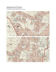
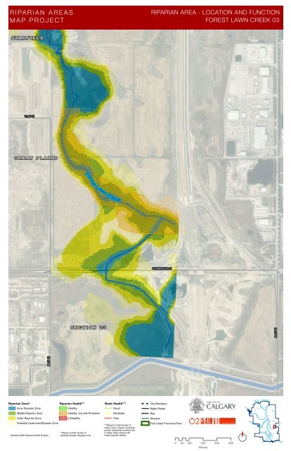
84 ST SE<br />
RIPAR IAN AREAS<br />
MA P PR OJECT<br />
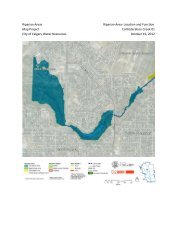
RIPARIAN AREA - LOCATION AND FUNCTION<br />
FOREST LAWN CREEK 03<br />
S TA R F I E L D<br />
72 AV SE<br />
G R E AT P L A I N S<br />
Fores<br />
t Lawn Creek<br />
GLENMORE TR SE<br />
S E C T I O N 2 3<br />
68 ST SE<br />
<strong>Riparian</strong> Zone*<br />
Inner <strong>Riparian</strong> Zone<br />
Middle <strong>Riparian</strong> Zone<br />
Outer <strong>Riparian</strong> Zone<br />
Potential Outermost <strong>Riparian</strong> Zone<br />
*Variable Width <strong>Riparian</strong> Model Outputs<br />
<strong>Riparian</strong> Health**<br />
Healthy<br />
Healthy, but with Problems<br />
Unhealthy<br />
**Based on field studies of<br />
sampled riparian polygons only<br />
Bank Health***<br />
Good<br />
Moderate<br />
Poor<br />
***Based on field studies of<br />
<strong>major</strong> rivers / creeks, excluding<br />
private residential riverfront lots<br />
or steep valley slopes with<br />
limited riparian habitat<br />
City Boundary<br />
Major Roads<br />
Rail<br />
Streams<br />
Fish Creek Provincial Park<br />
0 50 100 200 300 400<br />
Metres