
You also want an ePaper? Increase the reach of your titles
YUMPU automatically turns print PDFs into web optimized ePapers that Google loves.
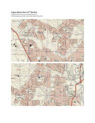
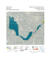
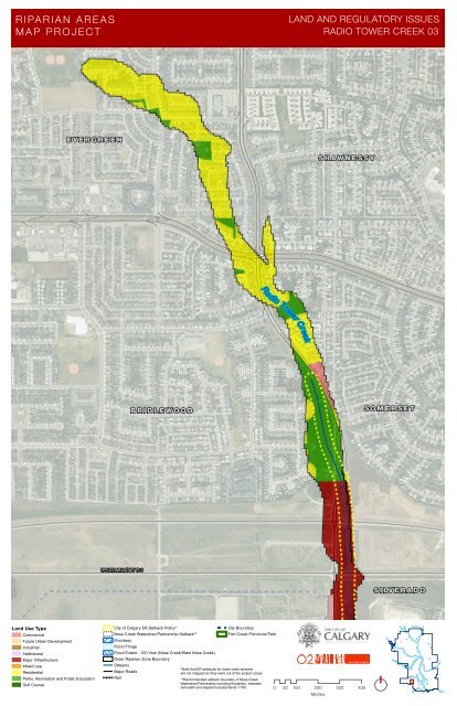
RIPAR IAN AREAS<br />
MA P PR OJECT<br />
LAND AND REGULATORY ISSUES<br />
RADIO TOWER CREEK 03<br />
E V E R G R E E N<br />
S H A W N E S S Y<br />
Radio Tower Creek<br />
B R I D L E W O O D<br />
S O M E R S E T<br />
SPRUCE MEADOWS TR S<br />
S I LV E R A D O<br />
L<strong>and</strong> Use Type<br />
Commercial<br />
Future Urban Development<br />
Industrial<br />
Institutional<br />
Major Infrastructure<br />
Mixed Use<br />
Residential<br />
Parks, Recreation <strong>and</strong> Public Education<br />
Golf Course<br />
City of <strong>Calgary</strong> ER Setback Policy*<br />
Nose Creek Watershed Partnership Setback**<br />
Floodway<br />
Flood Fringe<br />
Flood Extent - 100 Year (Nose Creek/West Nose Creek)<br />
Outer <strong>Riparian</strong> Zone Boundary<br />
Streams<br />
Major Roads<br />
Rail<br />
City Boundary<br />
Fish Creek Provincial Park<br />
*Note that ER setbacks for lower order streams<br />
are not mapped as they were out of the project scope<br />
**Recommended setback boundary of Nose Creek<br />
Watershed Partnership including floodplain, me<strong>and</strong>er<br />
belt width <strong>and</strong> adjacent escarpments >15%<br />
0 50 100 200 300 400<br />
Metres