
Create successful ePaper yourself
Turn your PDF publications into a flip-book with our unique Google optimized e-Paper software.
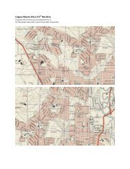
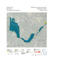
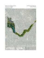
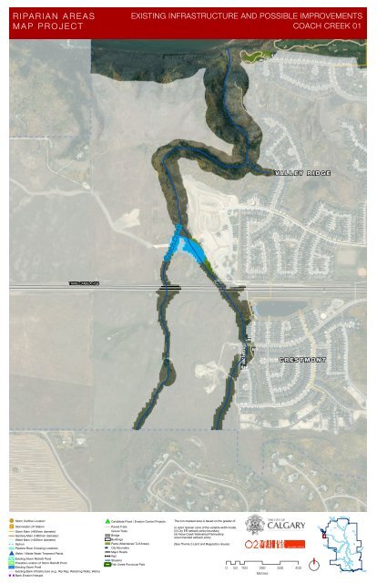
RIPAR IAN AREAS<br />
MA P PR OJECT<br />
EXISTING INFRASTRUCTURE AND POSSIBLE IMPROVEMENTS<br />
COACH CREEK 01<br />
V A L L E Y R I D G E<br />
Coach Creek<br />
TRANS CANADA HI W<br />
C R E S T M O N T<br />
!( Storm Outflow Location<br />
")<br />
Stormwater Lift Station<br />
Storm Main (>900mm diameter)<br />
Sanitary Main (>600mm diameter)<br />
Water Main (>400mm diameter)<br />
Siphon<br />
Pipeline River Crossing Locations<br />
#* Water / Waste Water Treament Plants<br />
Existing Storm Retrofit Pond<br />
Possible Location of Storm Retrofit Pond<br />
Existing Storm Pond<br />
Existing Bank Infrastructure (e.g., Rip Rap, Retaining Walls, Weirs)<br />
Bank Erosion Hotspot<br />
#* C<strong>and</strong>idate Flood / Erosion Control Projects<br />
Paved Trails<br />
Gravel Trails<br />
Bridge<br />
Buildings<br />
Parks (Maintained Turf Areas)<br />
City Boundary<br />
Major Roads<br />
Rail<br />
Streams<br />
Fish Creek Provincial Park<br />
The non-masked area is based on the greater of:<br />
(i) outer riparian zone of the variable width model,<br />
(ii) City ER setback policy boundary,<br />
(iii) Nose Creek Watershed Partnership<br />
recommended setback policy<br />
(See Theme 2-L<strong>and</strong> <strong>and</strong> Regulatory Issues)<br />
0 50 100 200 300 400<br />
Metres