CC1803

You also want an ePaper? Increase the reach of your titles
YUMPU automatically turns print PDFs into web optimized ePapers that Google loves.
CASE study<br />
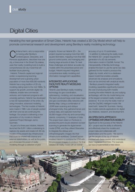
Digital Cities<br />
Heralding the next generation of Smart Cities, Helsinki has created a 3D City Model which will help to<br />
promote commercial research and development using Bentley's reality modeling technology<br />
Chintana Herrin, who is responsible<br />
for looking after Bentley's<br />
ContextCapture, Descartes, and<br />
Pointools applications, describes how one<br />
city, a forerunner in the Smart City stakes,<br />
uses their reality modelling tools to build a<br />
comprehensive 3D city model that will<br />
facilitate future planning.<br />
Helsinki, Finland's capital and regional<br />
center, is experiencing booming<br />
development and a growing urban<br />
population of more than 600,000 residents.<br />
Helsinki has a long tradition of 3D city<br />
modeling dating back to the mid-1980s. To<br />
support city growth, promote digital city<br />
initiatives, enable new commercial<br />
ventures, and implement programs with<br />
university partners, Helsinki has developed<br />
a new 3D representation of the entire city<br />
using innovative, advanced modeling<br />
technologies. "The first models of Helsinki<br />
were made in 1985. Lots of people worked<br />
with them and we are continuing this<br />
heritage. Our project is delivering a new<br />
generation of city models to Helsinki,"<br />
explained Project Manager Jarmo<br />
Suomisto.<br />
As part of a three-year initiative, Helsinki<br />
launched the EUR 1 billion undertaking to<br />
capture city assets and create rich 3D city<br />
models of the present-day infrastructure<br />
that could be shared with internal and<br />
external stakeholders, as well as the public,<br />
and showcase the power of reality<br />
modeling through a collection of pilot<br />
projects. Known as Helsinki 3D+, the<br />
project required surveying more than 500<br />
square kilometers, mapping more than 600<br />
ground control points, and managing and<br />
sharing large amounts of data. To meet<br />
these challenges and deliver accurate city<br />
models within the prescribed period and<br />
budget, Helsinki required integrated,<br />
comprehensive reality modeling and<br />
information management capabilities.<br />
INTEGRATED APPLICATIONS<br />
FACILITATE REALITY MODELING<br />
OPTIONS<br />
Helsinki used Bentley's reality modeling<br />
technology for geo-coordination,<br />
optioneering, modeling, and visualisation.<br />
The team produced large scale base maps<br />
and geo-coordinated utility networks with<br />
Bentley Map. Using a combination of<br />
LiDAR laser scanning and oblique<br />
photogrammetry, they gathered terrain and<br />
surface data, and captured more than<br />
50,000 images of the city and surrounding<br />
islands, comprising 11 terabytes of data.<br />
The project team relied on Pointools to<br />
process the point clouds obtained via laser<br />
scanning to generate the digital terrain<br />
model (DTM), and they utilised Descartes<br />
to integrate the oblique and<br />
orthophotographic images into their<br />
infrastructure workflows. ContextCapture<br />
enabled Helsinki to combine the DTM with<br />
the processed imagery to produce the final<br />
detailed 3D reality model with an overall<br />
accuracy of up to 10 centimeters.<br />
In addition to delivering the reality mesh,<br />
the Helsinki 3D+ project required the<br />
generation of a 3D city semantic<br />
information model in CityGML format. The<br />
interoperability of Bentley technology<br />
enabled the team to use the same raw data<br />
gathered for the model to produce this<br />
digital city model, which is a databasebased<br />
model that enables versatile,<br />
advanced city analyses and simulations<br />
that can be enriched with analytical results.<br />
Bentley's powerful integrated reality<br />
modeling capabilities significantly lowered<br />
the cost of producing both models<br />
covering the entire Helsinki city and outlying<br />
archipelago, with the city model being one<br />
of the largest consistent reality models in<br />
existence. "It is not only the reality mesh or<br />
only the CityGML intelligent model. We<br />
need both," stated Mr. Suomisto. Having<br />
two models extends applications for digital<br />
city initiatives, research, and development.<br />
AN OPEN DATA APPROACH<br />
OPTIMISES INFORMATION MOBILITY<br />
Significant to the success of the Helsinki<br />
3D+ project was the ability to efficiently<br />
and effectively share the models and<br />
project data and collaborate with<br />
stakeholders and the public. "We want to<br />
get the people of the city of Helsinki<br />
involved with these models and understand<br />
them," explained Suomisto. "For example,<br />
we have [implemented] a new citizen<br />
12<br />
March/April 2018