Final Bluebonnet Circle Master Plan - City of Fort Worth
Final Bluebonnet Circle Master Plan - City of Fort Worth
Final Bluebonnet Circle Master Plan - City of Fort Worth

You also want an ePaper? Increase the reach of your titles
YUMPU automatically turns print PDFs into web optimized ePapers that Google loves.
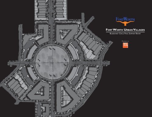
FORT WORTH URBAN VILLAGES<br />
BLUEBONNET CIRCLE FINAL SUMMARY REPORT<br />
PREPARED BY
Table <strong>of</strong> Contents ..............................1<br />
Project Background. ............................2<br />
Urban Village Program Background .............2<br />
<strong>Bluebonnet</strong> <strong>Circle</strong> Urban Village Progress ........3<br />
Village <strong>Plan</strong>ning ................................6<br />
Existing Conditions .........................6<br />
Existing Land Use ........................6<br />
Existing Zoning ..........................7<br />
Vacant/Underutilized Parcels ...............8<br />
Ownership Patterns ......................9<br />
Transportation ..........................9<br />
Building Blocks ............................11<br />
Townhouse ............................12<br />
Mixed-Use Type ‘A’ ......................13<br />
Mixed-Use Type ‘B’ ......................14<br />
Consensus Development <strong>Plan</strong> ................16<br />
I.<br />
TABLE OF CONTENTS<br />
Village <strong>Plan</strong>ning Cont.<br />
Urban Design .............................18<br />
Contemporary Theme ...................18<br />
Recommended Furnishings/Materials. .......18<br />
Prototypical Urban Design Concept ........22<br />
Architectural Character ..................24<br />
Transportation ............................26<br />
Context Sensitive Streets .................26<br />
Transportation Deficiencies and Needs. .....26<br />
Transportation Concept <strong>Plan</strong> ..............28<br />
Transportation Recommendations. .........29<br />
Transportation Project Prioritization ........30<br />
Neighborhood Zoning Recommendations ......31<br />
Appendices ..................................32<br />
Appendix 1 ...............................32<br />
Appendix 2 ...............................33<br />
Appendix 3 ...............................34<br />
Appendix 4 ...............................42<br />
1
II.<br />
PROJECT BACKGROUND<br />
Urban Village Program Background<br />
In 2002, the Commercial Corridors Task<br />
Force, with input from neighborhood<br />
stakeholders and community leaders, identified<br />
thirteen mixed use growth areas or<br />
“urban villages”. The thirteen villages were<br />
located along several <strong>of</strong> <strong>Fort</strong> <strong>Worth</strong>’s primary<br />
commercial corridors that held investment<br />
potential, despite social and economic redevelopment<br />
challenges. The Task Force’s approach<br />
for locating the urban villages was to<br />
strategically concentrate resources in select<br />
catalyst areas to have a positive economic<br />
impact along the corridor and into surrounding<br />
neighborhoods.<br />
An urban village is defined by the <strong>City</strong> as<br />
an urbanized place with a mix <strong>of</strong> uses, jobs,<br />
public spaces, transportation connections, pedestrian<br />
activity and a sense <strong>of</strong> place. Urban<br />
villages are frequently located at significant<br />
intersections and share certain design characteristics.<br />
Among those common characteristics<br />
are pedestrian-oriented buildings with<br />
minimal front yard setbacks, screened parking<br />
areas located to the rear or side <strong>of</strong> buildings,<br />
and buildings designed to accommodate<br />
changes in use over time. Other communities<br />
across the southwest have proven that<br />
these types <strong>of</strong> active, diverse, prosperous, and<br />
memorable urban villages can successfully<br />
re-established the central city as an appealing<br />
alternative to the generic and <strong>of</strong>ten congested<br />
<strong>of</strong>fice parks and subdivisions associated<br />
with suburban development.<br />
2<br />
In 2005, the <strong>City</strong> Council directed the <strong>City</strong><br />
<strong>Plan</strong> Commission to evaluate existing and<br />
potential new urban villages. The result <strong>of</strong><br />
that evaluation was the combining, elimination<br />
and addition <strong>of</strong> several villages. In order<br />
to promote urban village development, the<br />
<strong>City</strong> is currently constructing capital improvements<br />
to upgrade infrastructure and create<br />
high quality public spaces; applying economic<br />
incentives to make urban infill projects as pr<strong>of</strong>itable<br />
as suburban development; and applying<br />
mixed-use zoning to permit higher-density,<br />
pedestrian-oriented development consistent<br />
with community vision.
Urban Village<br />
II.<br />
PROJECT BACKGROUND<br />
<strong>Bluebonnet</strong> <strong>Circle</strong><br />
Village Progress<br />
The <strong>Bluebonnet</strong> <strong>Circle</strong> Urban Village is one<br />
<strong>of</strong> the villages that was added to the Urban<br />
Village program in November <strong>of</strong> 2005. Since<br />
2005, a community led effort has led to the<br />
creation <strong>of</strong> a new master plan for <strong>Bluebonnet</strong><br />
<strong>Circle</strong> Park. While no village boundary<br />
currently exists for the village, the study<br />
area for the Village <strong>Plan</strong>ning Study is generally<br />
bounded by Jeanette Drive and Rogers<br />
Avenue on the west, Cockrell Avenue on the<br />
east, Granbury Road on the South and Devitt<br />
Street on the North.<br />
3
II.<br />
PROJECT BACKGROUND<br />
<strong>Bluebonnet</strong> <strong>Circle</strong><br />
Urban Village Progress<br />
In March <strong>of</strong> 2007, the HOK <strong>Plan</strong>ning<br />
Group, along with Kimley-Horn Associates,<br />
and Pavlik and Associates, was engaged to<br />
initiate a two-phase process <strong>of</strong> developing<br />
urban village plans that are reflective <strong>of</strong> the<br />
vision that the <strong>Bluebonnet</strong> <strong>Circle</strong> stakeholders<br />
have for their village. Specifically, the<br />
scope <strong>of</strong> work related to the planning study<br />
included identifying development opportunities,<br />
preparing alternative development<br />
scenarios, identifying transportation needs<br />
and priorities, preparing a final urban village<br />
plan, preparing traffic engineering recommendations,<br />
preparing urban design concepts<br />
and recommendations, and providing<br />
recommendations related to the location <strong>of</strong><br />
a future village boundary.<br />
4<br />
Park <strong>Plan</strong> (Adopted May 2007 by the <strong>Fort</strong> <strong>Worth</strong> Parks Board)
This Page intentionally left blank<br />
5
III.<br />
VILLAGE PLANNING<br />
Existing Conditions<br />
A number <strong>of</strong> existing conditions were<br />
reviewed and studied as to their implications<br />
for future development within the<br />
<strong>Bluebonnet</strong> <strong>Circle</strong> Urban Village. Those<br />
conditions include existing land use, existing<br />
zoning, vacant parcels, and property<br />
ownership patterns.<br />
Existing Land Use<br />
Existing land use influences the planning<br />
process in several ways. As sites are evaluated<br />
for redevelopment opportunities, it<br />
is important to understand the surrounding<br />
land uses to assure that proposed<br />
future developments are compatible with<br />
the existing uses from the standpoint<br />
<strong>of</strong> use, height, and density. Additionally,<br />
land use can be an indicator <strong>of</strong> a site’s<br />
likelihood to redevelop. In many cases,<br />
institutional uses such as schools and<br />
churches are not as likely to redevelop as<br />
commercial or industrial uses.<br />
In the <strong>Bluebonnet</strong> <strong>Circle</strong> Village study<br />
area, a quality, single-family residential<br />
base provides the dominate land use. The<br />
exceptions to this use exist immediately<br />
adjacent to the <strong>Bluebonnet</strong> traffic circle,<br />
and one-half block on either side <strong>of</strong><br />
University Drive. The <strong>Bluebonnet</strong> traffic<br />
circle is surrounded by retail uses that<br />
contribute greatly to the areas eclectic<br />
character. North and south <strong>of</strong> the circle,<br />
multi-family residential uses are common.<br />
Additionally, at the southern gateway to<br />
the village at Granbury and University,<br />
<strong>of</strong>fice uses are prevalent.<br />
6<br />
Existing Land Use
Existing Zoning<br />
Existing Zoning<br />
III.<br />
VILLAGE PLANNING<br />
Existing Conditions<br />
Existing zoning influences the planning process<br />
by providing an indication <strong>of</strong> what type<br />
and density <strong>of</strong> development is currently<br />
allowed. The primary zoning within the<br />
<strong>Bluebonnet</strong> <strong>Circle</strong> study area is One-Family<br />
(5000sf) Residential, with Multiple Family<br />
(Medium Density) existing along University<br />
Drive north <strong>of</strong> the <strong>Bluebonnet</strong> traffic<br />
circle, and Multiple Family (Low Density)<br />
existing along University Drive south <strong>of</strong> the<br />
<strong>Bluebonnet</strong> traffic circle. The zoning on<br />
the properties immediately adjacent to the<br />
circle is General Commercial in the southeast<br />
quadrant and Neighborhood Commercial<br />
in the remaining quadrants. It should<br />
be noted that the Two-Family zoning which<br />
exists northwest <strong>of</strong> the intersection <strong>of</strong><br />
Benbrook Boulevard and University Drive<br />
zoning is inconsistent with the single family<br />
uses that exist on those same sites.<br />
7
III.<br />
VILLAGE PLANNING<br />
Existing Conditions<br />
Vacant/Underutilized Parcels<br />
Vacant parcels influence the planning<br />
process due to their potential ability to<br />
develop more rapidly than developed<br />
parcels, and with fewer constraints. In the<br />
<strong>Bluebonnet</strong> <strong>Circle</strong> Urban Village, very few<br />
vacant sites exist. However, many <strong>of</strong> the<br />
older multiple-family sites along University<br />
Drive, and commercial sites surrounding<br />
the <strong>Bluebonnet</strong> traffic circle could be<br />
considered underutilized and are ripe for<br />
re-development.<br />
8<br />
Vacant/Underutilized Parcels
Ownership Patterns<br />
Ownership Patterns<br />
III.<br />
VILLAGE PLANNING<br />
Existing Conditions<br />
Ownership patterns have a major impact<br />
on the ability <strong>of</strong> sites to develop in a substantial<br />
way. Large areas with few owners<br />
are much more likely to achieve the types<br />
<strong>of</strong> mixed-use development envisioned for<br />
the <strong>Bluebonnet</strong> <strong>Circle</strong> Urban Village than<br />
areas with smaller lots and multiple owners.<br />
In this village, the ownership patterns are<br />
relatively fragmented with the exception <strong>of</strong><br />
several <strong>of</strong> the multi-family properties along<br />
University Drive.<br />
Transportation<br />
In order for mixed-use development to<br />
occur within the <strong>Bluebonnet</strong> <strong>Circle</strong> Urban<br />
Village, several existing issues will need to be<br />
overcome including a current provision <strong>of</strong> too<br />
much vehicular access which causes confusion<br />
for drivers, too few parking spots for the<br />
existing businesses, vehicular conflicts which<br />
cause weaving, disconnected sidewalks and no<br />
clear pedestrian crossings <strong>of</strong> existing streets.<br />
Access management, improved sidewalks, defined<br />
pedestrian crossings, improved geometrics<br />
including an upgrade to modern roundabout<br />
standards can all assist in overcoming<br />
those issues.<br />
9
10<br />
This Page intentionally left blank
III.<br />
VILLAGE PLANNING<br />
BUILDING BLOCKS<br />
Several development types or “building<br />
blocks” exist that would be appropriate to<br />
achieve the future built environment envisioned<br />
by stakeholders for the <strong>Bluebonnet</strong><br />
<strong>Circle</strong> Urban Village, while responding to the<br />
nuances <strong>of</strong> each site related to adjacent land<br />
use, ownership patterns, and zoning. The<br />
following pages summarize the development<br />
types recommended for the <strong>Bluebonnet</strong><br />
<strong>Circle</strong> Urban Village.<br />
11
III.<br />
VILLAGE PLANNING<br />
BUILDING BLOCKS<br />
Townhouse<br />
Characteristics<br />
�� ����������������������<br />
�� �����������������������������<br />
�� ������������������������������������������<br />
�� ������������������<br />
�� ����������������������������<br />
�� ���������������������������������������<br />
����������<br />
�� �����������������������������<br />
Key Zoning Standards – MU-1<br />
���������������������� ����������������<br />
��������������������� ����������������<br />
���������������������������� �������������<br />
��������������������������� ������������� <strong>Plan</strong> Delineation Built Form<br />
12<br />
Built Form
Built Form<br />
Built Form<br />
<strong>Plan</strong> Delineation<br />
III.<br />
VILLAGE PLANNING<br />
BUILDING BLOCKS<br />
Mixed-Use Type ‘A’<br />
Characteristics<br />
�����������������������������<br />
��������������������<br />
����������������������������������������������<br />
������������������������������������<br />
����������������������������������<br />
���������������������������������������<br />
�����������������������������������������<br />
����������<br />
�������������������������������<br />
Key Zoning Standards – MU-1<br />
���������������������� ����������������*<br />
��������������������� ����������������<br />
���������������������������� �������������*<br />
��������������������������� �������������<br />
* Single use discouraged<br />
13
III.<br />
VILLAGE PLANNING<br />
BUILDING BLOCKS<br />
Mixed-Use Type ‘B’<br />
Characteristics<br />
�� ���������������������������<br />
�� ����������������������������������<br />
�� ������������������������<br />
�� ���������������������������������������<br />
�������������������������������������<br />
�� ����������������������������������<br />
����������������������������������������<br />
�����������������������������������������<br />
�� �����������������������������������������<br />
�������<br />
�� �������������������������������������<br />
�� ���������������������������������������<br />
����������<br />
�� �����������������������������<br />
Key Zoning Standards – MU-1<br />
���������������������� ����������������*<br />
��������������������� ����������������<br />
���������������������������� �������������*<br />
��������������������������� �������������<br />
* Single use discouraged<br />
14<br />
<strong>Plan</strong> Delineation Built Form<br />
Built Form
This Page intentionally left blank<br />
15
III.<br />
VILLAGE PLANNING<br />
Consensus Development <strong>Plan</strong><br />
The consensus development plan responds<br />
to the goals and desires for the types <strong>of</strong><br />
development expressed by the stakeholders<br />
in the first stakeholder meeting (see Appendix<br />
3). The plan represents the consensus<br />
<strong>of</strong> the comments received related to the<br />
two preliminary development scenarios<br />
presented to the community in the second<br />
stakeholder meeting (see Appendix 1).<br />
Townhouse development is recommended<br />
for the northern sections <strong>of</strong> the village on<br />
both sides <strong>of</strong> University Drive from the<br />
south side <strong>of</strong> Devitt to just north <strong>of</strong> <strong>Bluebonnet</strong><br />
<strong>Circle</strong>. This continues the development<br />
pattern established to the north <strong>of</strong><br />
<strong>Bluebonnet</strong> <strong>Circle</strong> Urban Village within the<br />
Berry/University Village. This pattern is recommended<br />
due to the limited lot depth <strong>of</strong><br />
the existing lots, and the proximity to single<br />
family residential uses. On the northwest<br />
and southwest corners <strong>of</strong> University Drive<br />
and Benbrook, the plan calls for existing<br />
structures to remain in place, a desire<br />
expressed by the neighborhood in the<br />
stakeholder meetings.<br />
South <strong>of</strong> <strong>Bluebonnet</strong> <strong>Circle</strong> and extending<br />
to the intersection with South Hills, new<br />
condominium development is currently<br />
taking place and is expected to remain<br />
in place for the development time frame<br />
established for this village plan. Mixed-use<br />
Type A development is recommended on<br />
the northeast and northwest quadrants <strong>of</strong><br />
the intersection <strong>of</strong> Cleburne and University,<br />
and extending north to South Hills.<br />
16<br />
Development around <strong>Bluebonnet</strong> <strong>Circle</strong><br />
is recommended to become a mix <strong>of</strong> old<br />
and new. The closure <strong>of</strong> Biddison west <strong>of</strong><br />
the circle, and Park Ridge east <strong>of</strong> the circle<br />
provides opportunities for new mixed-use<br />
type B development due to the additional<br />
property that could be added to the surrounding<br />
commercial sites. Mixed-use Type<br />
B development is also recommended for the<br />
sites at the southwest corner <strong>of</strong> Park Ridge<br />
and University, and at the northwest corner<br />
<strong>of</strong> University and <strong>Bluebonnet</strong> <strong>Circle</strong>. These<br />
properties both have the depth to accommodate<br />
the structured parking associated<br />
with this type <strong>of</strong> development. Mixed-use<br />
Type A development is recommended for<br />
the northeast and southeast corners <strong>of</strong><br />
University and <strong>Bluebonnet</strong> <strong>Circle</strong>. All <strong>of</strong> this<br />
development would be carefully placed to<br />
integrate with existing commercial buildings<br />
in the northwest and southeast quadrants <strong>of</strong><br />
the circle.<br />
<strong>Plan</strong> Statistics<br />
������������ ���������<br />
��������� ��<br />
��������� ��<br />
������������� ��<br />
������������������ ��<br />
�������������������� ����������<br />
������� ���������<br />
������������������ �������
Consensus Development <strong>Plan</strong><br />
III.<br />
VILLAGE PLANNING<br />
Consensus Development <strong>Plan</strong><br />
17
III.<br />
VILLAGE PLANNING<br />
Urban Design<br />
Contemporary Theme<br />
Two urban design themes were developed<br />
and presented to the community in the<br />
second stakeholder meeting. The Urban<br />
Eclectic Theme is based upon the eclectic<br />
group <strong>of</strong> commercial buildings that currently<br />
exist at <strong>Bluebonnet</strong> <strong>Circle</strong> and suggests<br />
creating an eclectic grouping <strong>of</strong> streetscape<br />
elements that have the ability to work<br />
together as a family <strong>of</strong> design elements. The<br />
Contemporary Theme is rooted in establishing<br />
a contemporary set <strong>of</strong> urban design<br />
elements to provide unification within the<br />
eclectic commercial areas at <strong>Bluebonnet</strong><br />
<strong>Circle</strong>. The stakeholders in the <strong>Bluebonnet</strong><br />
<strong>Circle</strong> Urban Village expressed a preference<br />
for the elements <strong>of</strong> the Contemporary<br />
Theme.<br />
The intent <strong>of</strong> the Contemporary Theme<br />
is to allow the architecture and signage <strong>of</strong><br />
each building or business to continue to<br />
evolve in a more eclectic manner, but to<br />
provide a series <strong>of</strong> public streetscape elements<br />
at ground level that provide a sense<br />
<strong>of</strong> commonality within the village.<br />
Recommended Furnishings / Materials<br />
The following site furnishings and materials<br />
are recommended for use within the <strong>Bluebonnet</strong><br />
<strong>Circle</strong> Urban Village and are compatible<br />
with the Contemporary Theme:<br />
18
Pedestrian / Bollard Lights<br />
KIM - Solitaire<br />
Street Light<br />
KIM - Solitaire<br />
III.<br />
VILLAGE PLANNING<br />
Urban Design<br />
19
III.<br />
VILLAGE PLANNING<br />
Urban Design<br />
Street Furniture<br />
20<br />
Benches<br />
Landscape Forms - Presidio<br />
Litter Receptacle<br />
Landscape Forms - Presidio<br />
<strong>Plan</strong>ters<br />
Landscape Forms - Rosa
Concrete Pavers<br />
Pavestone - Buff / Antique<br />
Terra Cotta Blend<br />
Tree Grates<br />
Canterbury - Palisades<br />
III.<br />
VILLAGE PLANNING<br />
Urban Design<br />
Ground <strong>Plan</strong>e<br />
21
III.<br />
VILLAGE PLANNING<br />
Prototypical Urban Design Concept<br />
The prototypical urban design concept<br />
assembles the recommended materials and<br />
furnishings in a manner that is unique to the<br />
<strong>Bluebonnet</strong> <strong>Circle</strong> Urban Village. The concept<br />
focuses upon connecting existing and new<br />
development outside <strong>of</strong> the traffic circle with<br />
the improved <strong>Bluebonnet</strong> Park on the inside<br />
<strong>of</strong> the circle. All elements related to the<br />
concept seek to reinforce the unique circular<br />
character <strong>of</strong> the site. Bands <strong>of</strong> colored concrete<br />
pavers are proposed to alternate with<br />
bands <strong>of</strong> standard, poured in place concrete in<br />
a radial pattern to reinforce the existence <strong>of</strong><br />
the circle. Additionally, the benches recommended<br />
for use within the village have the<br />
ability to be installed in a radial manner, thus<br />
reinforcing the curvature <strong>of</strong> the roadway.<br />
<strong>Final</strong>ly, the trees recommended for use at the<br />
outer edge <strong>of</strong> the roadway are either Italian<br />
Cypress or Pond Cypress, both <strong>of</strong> which have<br />
a columnar form, and if planted with a relatively<br />
tight spacing, have the ability to create<br />
or reinforce edge as necessary.<br />
22<br />
<strong>Plan</strong> View<br />
Isometric View
This Page intentionally left blank<br />
III.<br />
VILLAGE PLANNING<br />
Prototypical Urban Design Concept<br />
23
III.<br />
VILLAGE PLANNING<br />
Urban Design<br />
Architectural Character<br />
One <strong>of</strong> the overriding comments that were<br />
consistently expressed by the community<br />
in the stakeholder meetings was related to<br />
maintain the eclectic feel that currently exists<br />
with the commercial buildings. Several<br />
characteristics assist in achieving the commercial<br />
eclectic flavor <strong>of</strong> the village including<br />
variation in building materials, first floor<br />
awnings that are unique to each building,<br />
and unique signage for each business. The<br />
following images provide examples <strong>of</strong> these<br />
characteristics:<br />
24<br />
Variation <strong>of</strong> Building Materials
First Floor Awnings<br />
III.<br />
VILLAGE PLANNING<br />
Urban Design<br />
25
III.<br />
VILLAGE PLANNING<br />
Transportation<br />
Traffic Engineering<br />
Context Sensitive Streets<br />
The overriding approach to creating context<br />
sensitive streets within the <strong>Bluebonnet</strong><br />
<strong>Circle</strong> Urban Village is to respect traditional<br />
street design objectives for safety, efficiency,<br />
capacity, and maintenance, while integrating<br />
community objectives and values relating<br />
to compatibility, livability, sense <strong>of</strong> place,<br />
urban design, cost, and environmental<br />
impacts. Roadways within the village should<br />
be designed to move people, not just cars.<br />
Consideration must be made for transit,<br />
walking and biking.<br />
Transportation Deficiencies<br />
and Needs Analysis<br />
Currently, <strong>Bluebonnet</strong> <strong>Circle</strong> does not operate<br />
as a roundabout, but rather as four staggered<br />
intersections controlled by yield signs<br />
which create difficult merges for vehicles and<br />
an unpredictable environment for pedestrians<br />
and bicyclists (Image 1).<br />
Traffic modeling is needed to redesign and<br />
transform the circle into a roundabout, thus<br />
improving safety and reducing congestion<br />
(Image 2).<br />
Minor improvements to <strong>Bluebonnet</strong> <strong>Circle</strong>,<br />
such as adding raised median triangles at the<br />
intersections (Image 4) instead <strong>of</strong> the current<br />
pavement markers (Images 3 and 5), would<br />
aid in defining the circle and reducing the<br />
accumulation <strong>of</strong> debris.<br />
26<br />
Image 1<br />
Image 2<br />
Image 3<br />
Image 4<br />
Image 5
This Page intentionally left blank<br />
III.<br />
VILLAGE PLANNING<br />
Transportation<br />
27
III.<br />
VILLAGE PLANNING<br />
Transportation<br />
Transportation Concept <strong>Plan</strong><br />
The transportation concept plan responds<br />
to the future townhouse development<br />
north <strong>of</strong> <strong>Bluebonnet</strong> <strong>Circle</strong> with on-street<br />
parking to serve that use. Also, the plan<br />
calls for significant improvements to <strong>Bluebonnet</strong><br />
<strong>Circle</strong> to solve the current transportation<br />
deficiencies, as well as to create<br />
a vibrant pedestrian realm. Appendix 4<br />
provides additional detail related to traffic<br />
counts and levels <strong>of</strong> service for the existing<br />
<strong>Bluebonnet</strong> <strong>Circle</strong> as well as the future<br />
modified <strong>Bluebonnet</strong> <strong>Circle</strong>.<br />
*The proposed transportation improvements<br />
are conceptual in nature and subject<br />
to further study by <strong>City</strong> staff. The <strong>City</strong> shall<br />
not proceed to implement the proposed<br />
improvements pending such study and a<br />
corresponding amendment to the <strong>Master</strong><br />
Thoroughfare <strong>Plan</strong>.<br />
28<br />
Transportation Concept <strong>Plan</strong> with Street Closures<br />
at Biddison and Park Ridge (highlighted in red)<br />
Transportation Concept <strong>Plan</strong> without Street Closures
Project<br />
<strong>Plan</strong>ning Level Cost Estimate for <strong>Bluebonnet</strong>t <strong>Circle</strong> Improvements<br />
Construction<br />
Cost<br />
Design and<br />
Administration Funding Source<br />
Restripe University Drive from Benbrook Blvd.<br />
to Butler Rd. to have on-street parking, bicycle<br />
lanes, and two through lanes. Redesign<br />
<strong>Bluebonnet</strong> <strong>Circle</strong> to have one lane (move in<br />
curb line), close northeast Park Ridge Drive<br />
Unknown, CIP,<br />
approach and west Biddison approach to the<br />
NCTCOG<br />
circle, provide crosswalks to park, reconstruct<br />
Sustainable<br />
continuous sidewalks, construct approach islands<br />
Development Grant,<br />
on all intersections, and reconstruct portions <strong>of</strong><br />
TxDOT<br />
parking lots. $605,000 $115,000 Enhancement Grant<br />
* The above planning level estimate does not include streetscape estimates for improvements around the circle. Streetscape improvements could add<br />
approximately $300,000-$350,000 dollars to the overall project. (Numbers are based on estimates provided the <strong>City</strong> <strong>of</strong> <strong>Fort</strong> <strong>Worth</strong>.)<br />
III.<br />
VILLAGE PLANNING<br />
Transportation<br />
Transportation Recommendations<br />
The long range transportation recommendations<br />
for the <strong>Bluebonnet</strong> <strong>Circle</strong> Village include<br />
restriping University Drive from Benbrook<br />
Boulevard to Butler Road to allow for onstreet<br />
parking, bicycle lanes, and two through<br />
lanes. It is also recommended that <strong>Bluebonnet</strong><br />
<strong>Circle</strong> be reconfigured to a one lane<br />
cross section, and to close the northeast Park<br />
Ridge Drive and west Biddison approaches to<br />
the circle. Traffic that now enters the circle<br />
from northeast Park Ridge Drive would be<br />
redirected to Cockrell and to Benbrook, and<br />
traffic that now enters from west Biddison<br />
would be redirected to Rogers and Benbrook.<br />
It is also recommended that crosswalks be<br />
constructed to <strong>Bluebonnet</strong> <strong>Circle</strong> Park, that<br />
continuous sidewalks be constructed around<br />
the circle, and that approach islands be constructed<br />
on all remaining intersections at the<br />
circle.<br />
<strong>Final</strong>ly, these transportation recommendations<br />
were formed based on a focused study<br />
with stakeholders from within the <strong>Bluebonnet</strong><br />
<strong>Circle</strong> Urban Village. It is recommended that,<br />
when a funding source for these improvements<br />
is identified, the next step related to<br />
all <strong>of</strong> these recommendations should be to<br />
engage additional stakeholders from the city<br />
at large, and to undertake informational and<br />
educational briefings as to how the changes<br />
to the roadway will function regionally.<br />
29
III.<br />
VILLAGE PLANNING<br />
Transportation<br />
Transportation Project Prioritization<br />
30<br />
Priority<br />
drop<br />
Roadway /<br />
lane/lane<br />
R�O�W Roadway Segment<br />
Slip<br />
1 1 University<br />
2 2 <strong>Circle</strong><br />
3 3 Biddison<br />
4 4 <strong>Circle</strong><br />
5 5 <strong>Circle</strong><br />
6 6 <strong>Circle</strong><br />
7 7 <strong>Circle</strong><br />
8 8 <strong>Circle</strong><br />
������������������������������������������������<br />
for on street parking.<br />
Devitt to W. W. Butler<br />
University University to to Biddison<br />
Biddison<br />
<strong>Circle</strong> Intersection<br />
Biddison Biddison to to University<br />
University<br />
University University to to Biddison<br />
Biddison<br />
Biddison to Park Ridge<br />
Park Ridge to University<br />
Park Ridge Intersection<br />
Transit Pavilion<br />
Mid�Block Crossing<br />
Add Turn Lane(s)<br />
Technique<br />
Bulb Out*<br />
Sidewalk / Pedestrian<br />
Passageway<br />
Close Street /<br />
Remove Driveway<br />
Median Closure /<br />
Channelization<br />
Intersection<br />
Modification
Recommended Village Boundary<br />
III.<br />
VILLAGE PLANNING<br />
Neighborhood Zoning<br />
Recommendations<br />
As was discovered in the review <strong>of</strong> existing<br />
land use and zoning in the <strong>Bluebonnet</strong><br />
<strong>Circle</strong> Urban Village, many <strong>of</strong> the single family<br />
neighborhoods surrounding the mixed-use<br />
zoning boundary are zoned as two-family. It<br />
is recommended that the neighborhoods consider<br />
asking the <strong>Fort</strong> <strong>Worth</strong> <strong>City</strong> Council to<br />
initiate a rezoning process to bring the areas<br />
with two-family zoning into conformance with<br />
the current single family use.<br />
Additionally, to better accommodate appropriate<br />
development on the sites along University<br />
Drive with extremely limited depths<br />
and adjacency to single family uses, the <strong>City</strong><br />
should consider changes to current MU-1<br />
standards to address contextual heights when<br />
MU-1 abuts single or two-family uses.<br />
<strong>Final</strong>ly, the <strong>Bluebonnet</strong> <strong>Circle</strong> Urban Village<br />
Boundary should be established ½ block back<br />
on the east and west sides <strong>of</strong> University, and<br />
from the village boundary <strong>of</strong> the Berry/University<br />
Village on the north, to the north side<br />
<strong>of</strong> Granbury on the south, and incorporate<br />
the existing commercial properties at the<br />
existing circle. When rezoning takes place in<br />
this village, the process should move forward<br />
in two phases. The first phase would take in<br />
the boundary shown as a solid line and be rezoned<br />
as MU-1. The area noted in the dashed<br />
line should only be rezoned if and when an<br />
urban residential category is adopted by the<br />
<strong>City</strong>, or changes are made to MU-1 standards<br />
to improve height compatibility with the abutting<br />
single family uses.<br />
31
IV.<br />
APPENDICES<br />
Appendix 1<br />
Preliminary Development Scenarios<br />
The preliminary development scenarios,<br />
which were presented to the community in<br />
the second stakeholder meeting, represent<br />
two potential visions for future development<br />
in the <strong>Bluebonnet</strong> <strong>Circle</strong> Urban Village.<br />
Scenario ‘A’ represents a less intense<br />
future for development, and Scenario ‘B’ a<br />
more intense future. The scenarios were<br />
designed to provide alternatives to the intensity<br />
and types <strong>of</strong> development that could<br />
occur on each key site within the village<br />
so that the stakeholders could discuss the<br />
merits <strong>of</strong> each approach in order to reach<br />
consensus.<br />
32<br />
Scenario A Scenario B
Building<br />
Number<br />
Residential Commercial / Retail Office<br />
Floor<br />
Plate Floors Gross SF<br />
Gross<br />
SF/Unit Units<br />
Parking /<br />
Code<br />
Required<br />
Parking<br />
Floor<br />
Plate Floors Gross SF<br />
Parking<br />
Code<br />
Required<br />
Parking<br />
Floor<br />
Plate Floors Gross SF<br />
Parking<br />
Code<br />
Required<br />
Parking<br />
Total<br />
Required<br />
Parking<br />
Total SF<br />
Parking<br />
Structured<br />
(1/300) Lot Area<br />
Parking<br />
Floors Total Floors<br />
1 4090 1.00 4090 1100 4 1.6 6 4090 1.00 4090 1 / 250 SF 16 4090 0.00 0 1/400 SF 0 22 6,693 2<br />
2 6068 1.00 6068 1100 6 1.6 9 6068 1.00 6068 1 / 250 SF 24 6068 0.00 0 1/400 SF 0 33 10,591 2<br />
3 5735 1.00 5735 1100 5 1.6 8 5735 1.00 5735 1 / 250 SF 23 5735 0.00 0 1/400 SF 0 31 10,010 2<br />
4 4487 1.00 4487 1100 4 1.6 7 4487 1.00 4487 1 / 250 SF 18 4487 0.00 0 1/400 SF 0 24 7,832 2<br />
5 4487 1.00 4487 1100 4 1.6 7 4487 1.00 4487 1 / 250 SF 18 4487 0.00 0 1/400 SF 0 24 7,832 2<br />
6 4487 1.00 4487 1100 4 1.6 7 4487 1.00 4487 1 / 250 SF 18 4487 0.00 0 1/400 SF 0 24 7,832 2<br />
7 4487 1.00 4487 1100 4 1.6 7 4487 1.00 4487 1 / 250 SF 18 4487 0.00 0 1/400 SF 0 24 7,832 2<br />
8 6347 1.00 6347 1100 6 1.6 9 6347 1.00 6347 1 / 250 SF 25 6347 0.00 0 1/400 SF 0 35 11,078 2<br />
9 3630 1.00 3630 1100 3 1.6 5 3630 1.00 3630 1 / 250 SF 15 3630 0.00 0 1/400 SF 0 20 6,336 2<br />
10 8670 0.00 0 1100 0 1.6 0 8670 1.00 8670 1 / 250 SF 35 8670 1.00 8670 1/400 SF 22 56 18,034 2<br />
11 14380 0.00 0 1100 0 1.6 0 14380 1.00 14380 1 / 250 SF 58 14380 1.00 14380 1/400 SF 36 93 29,910 2<br />
12 19158 2.00 38316 1100 35 1.6 56 19158 1.00 19158 1 / 250 SF 77 19158 0.00 0 1/400 SF 0 132 39,709 3<br />
13 16175 1.00 16175 1100 15 1.6 24 16175 1.00 16175 1 / 250 SF 65 16175 0.00 0 1/400 SF 0 88 26,468 1 30823 0.86 3<br />
14 21295 1.00 21295 1100 19 1.6 31 21295 1.00 21295 1 / 250 SF 85 21295 0.00 0 1/400 SF 0 116 34,846 1 31273 1.11 3<br />
15 19274 1.00 19274 1100 18 1.6 28 19274 1.00 19274 1 / 250 SF 77 19274 0.00 0 1/400 SF 0 105 31,539 1 27949 1.13 3<br />
Total 138,878 126 202 142,770 571 23,050 58 831<br />
% 45.6% 46.9% 7.6%<br />
L<strong>of</strong>t 40<br />
Flats 86<br />
Townhouse 85<br />
Condos 59<br />
Total<br />
Residential<br />
Units 270<br />
Total SF Development(*) 304,698<br />
* Does not include SF <strong>of</strong> Townhouse<br />
Consensus Development <strong>Plan</strong><br />
1<br />
2<br />
9<br />
3 4 5<br />
8<br />
7<br />
6<br />
10<br />
15<br />
14<br />
11<br />
13<br />
12<br />
IV.<br />
APPENDICES<br />
Appendix 2<br />
Development Summary<br />
This development summary chart<br />
indicates the assumptions made re�<br />
lated to mix <strong>of</strong> use, height and unit<br />
size for each new building indicated<br />
on the consensus development plan.<br />
The floor plates indicate the actual<br />
building footprints indicated on the<br />
plan, and parking requirements are<br />
based roughly upon the require�<br />
ments indicated within the <strong>City</strong> <strong>of</strong><br />
<strong>Fort</strong> <strong>Worth</strong> Development Code. All<br />
results indicate the order <strong>of</strong> magni�<br />
tude <strong>of</strong> development, and were used<br />
by the consulting team as a test to<br />
the basic feasibility <strong>of</strong> the develop�<br />
ment indicated.<br />
33
IV.<br />
APPENDICES<br />
Appendix 3<br />
Summary <strong>of</strong> Stakeholder<br />
Meeting Comments<br />
�������������������<br />
�������������������<br />
��������������������������<br />
������������<br />
34<br />
Community Meeting 1 – Dee J. Kelly Center - Texas<br />
Christian University – June 2, 2007<br />
The first community meeting <strong>of</strong> the <strong>Bluebonnet</strong> <strong>Circle</strong> Urban<br />
Village planning initiative was convened by Kirk Millican,<br />
Senior Vice President, HOK. <strong>Fort</strong> <strong>Worth</strong> Council Member<br />
Wendy Davis, District 9, welcomed all and encouraged full<br />
participation in the process so that the vision for <strong>Bluebonnet</strong><br />
<strong>Circle</strong> would be shared by all. (See the attached summary<br />
for listing <strong>of</strong> attendees.)<br />
Mr. Millican gave a summary <strong>of</strong> <strong>Fort</strong> <strong>Worth</strong>’s Central <strong>City</strong><br />
Revitalization Strategy, which incorporates the urban village<br />
concept that combines a mixture <strong>of</strong> uses, jobs, public<br />
spaces, transportation connections, pedestrian activity, and<br />
sense <strong>of</strong> place. He noted that the <strong>City</strong> can utilize capital<br />
improvement programs and economic incentives to stimulate<br />
revitalization, as well as apply mixed-use zoning that<br />
is higher density and pedestrian-oriented, consistent with<br />
the community’s vision for the area. It was noted that the<br />
<strong>City</strong>’s planning study for the <strong>Bluebonnet</strong> <strong>Circle</strong> Park is now<br />
complete, and there is input coming from <strong>Fort</strong> <strong>Worth</strong>’s Arts<br />
Commission.<br />
Discussion began with the recognition that single family homeowners<br />
are experiencing encroachment from the <strong>Circle</strong>’s<br />
businesses with patrons parking on residential streets at all<br />
times <strong>of</strong> the day. Council Member Davis noted that mixeduse<br />
planning concepts generally succeed because <strong>of</strong> density.<br />
She said there is a “tipping point” for the community as<br />
it evolves, and she is hopeful the study will address how<br />
changes can occur logically and with community acceptance.<br />
In order to plan appropriately, she said, consensus should<br />
be reached as to the “block depth” in the area; that being<br />
whether businesses move further into where houses are<br />
currently, or whether businesses do not extend any further.<br />
Parking<br />
Participants agreed that parking is very problematic, with<br />
the perception that parking behind the buildings is not safe.<br />
Parking should be organized; areas should be striped.<br />
Traffic<br />
The speed <strong>of</strong> vehicles entering into the circle from the<br />
north and south <strong>of</strong>f <strong>of</strong> University is a problem. It was suggested<br />
that the circle traffic should be limited to only one<br />
lane, not the current two. Also, vehicles already “on” the<br />
traffic circle should have the right-<strong>of</strong>-way; not cars coming<br />
“onto” the circle. Several participants said the roadway<br />
appears “over-designed” and that with the SW Parkway,<br />
there would not be the need to move traffic “through” the<br />
area. They said it is acceptable to have traffic congestion in<br />
the area at peak times. All said they would welcome “traffic<br />
calming” schemes.<br />
Pedestrian Orientation<br />
The circle has three bus stops, two <strong>of</strong> which have shelters;<br />
though participants said service is irregular. They feel that<br />
buses and automobiles “compete” for road space. They<br />
said they know people feel it is unsafe to cross the street<br />
with the traffic moving so fast. There are no sidewalks or<br />
trees which would encourage pedestrians to walk from one<br />
establishment to another. People get into their cars to drive<br />
“several doors down” on the circle. Streets funneling traffic<br />
into the circle do not invite pedestrians to walk along them.<br />
It was suggested that the area could benefit with a trolley.<br />
Signage<br />
The group agreed that pole signs are good because they do<br />
not block one’s vision. It was suggested that TCU’s banners<br />
should be continued into the circle area. Several said<br />
banners outside retail establishments are not attractive and<br />
should be controlled. It was noted that the <strong>City</strong> is working<br />
on a new sign ordinance that could provide guidelines for<br />
areas like <strong>Bluebonnet</strong> <strong>Circle</strong>. Another participant said there<br />
is an aversion to the <strong>City</strong> dictating style, color and configu-
ations. It was agreed that new lighting in the area could<br />
address numerous issues.<br />
Visions for the <strong>Circle</strong><br />
The group was asked the question, “Are area residents<br />
taking advantage <strong>of</strong> what occupies the circle or is the circle<br />
a destination for others?” The response was that both<br />
statements are true. Several said the area should not be<br />
“over-retailed.” Among the businesses that would be most<br />
desirable are: pr<strong>of</strong>essional services on the second-floor <strong>of</strong><br />
buildings, restaurants, wine bar, c<strong>of</strong>fee shop, ice cream parlor,<br />
book store, and park kiosk. Concerns were raised about<br />
plans for student housing south <strong>of</strong> the circle on University.<br />
Another participant said that the area probably did not have<br />
the mass to make a true urban village successful.<br />
“Most Sacred”<br />
When asked what is most sacred about <strong>Bluebonnet</strong> <strong>Circle</strong>,<br />
the following answers were given.<br />
– Existence <strong>of</strong> the park; it should never be bisected<br />
in any way<br />
– Different, distinctive, eclectic environments<br />
– Single family neighborhoods should not be changed<br />
radically with redevelopment<br />
– Historic character, scale <strong>of</strong> houses<br />
What to consider<br />
Participants said they are looking forward to looking at<br />
form-based codes, multi-use zoning with PD applications,<br />
public art applications, reconfiguration <strong>of</strong> traffic patterns,<br />
looking at development possibilities to the north and south<br />
on University, and resolution <strong>of</strong> parking problems.<br />
Attendees (Elected Officials, Staff, Consultants)<br />
������������ �������������������������� � ������������������<br />
����������������������� �������� � ����������������������������������������������<br />
���������������� ������������������� � ����������������������������������������������<br />
������������ � � �����������������������������������<br />
�������������� ����������������� � ����������������������������������������������<br />
����������������� �������� � ����������������������������������������������<br />
������������� ����������� � ���������������������<br />
���������� ��������������� � ���������������������������������������������������<br />
�������������� ����������� � ���<br />
������������� ����������� � ���������������������<br />
�������������� ����������� � ���<br />
������������� ����������� � ��������������������������<br />
Participants<br />
���������������������� ���������� � ������������������<br />
������������� ���������� � ������������������<br />
������������ ���������� � ������������������������<br />
������������ ���������� � ������������������<br />
�������������� ��������������������� � ��������<br />
��������������� ��������� � ������������������<br />
������������������������ ������������ � �����������������������<br />
�������������� ���������� � ���������������<br />
������������������������ ���������� � ������������������<br />
������������� ��������������������� � ����������<br />
IV.<br />
APPENDICES<br />
Appendix 3<br />
Summary <strong>of</strong> Stakeholder<br />
Meeting Comments<br />
�������������������<br />
�������������������<br />
��������������������������<br />
������������<br />
35
IV.<br />
APPENDICES<br />
Appendix 3<br />
Summary <strong>of</strong> Stakeholder<br />
Meeting Comments<br />
�������������������<br />
��������������������<br />
��������������������������<br />
�������������<br />
36<br />
Community Meeting 2 – Dee J. Kelly Center<br />
4- Texas Christian University – July 21, 2007<br />
The second community meeting <strong>of</strong> the <strong>Bluebonnet</strong> <strong>Circle</strong><br />
Urban Village planning initiative was convened by Mark<br />
Bowers, Group Vice President, HOK, at Dee J. Kelly Center<br />
on the campus <strong>of</strong> Texas Christian University. <strong>Fort</strong> <strong>Worth</strong><br />
Council Member Wendy Davis joined the group. (See the<br />
attached listing <strong>of</strong> all attendees.)<br />
Mr. Bowers asked attendees to think about how they would<br />
like the area to look in the next 20, 25 or 50 years, or what<br />
would be the “ultimate” vision for the area. He said the<br />
scenarios presented may or may not be right for the area,<br />
but everyone should comment on them so that the plan<br />
being developed is truly theirs. The village was created in<br />
November 2005 and a community led park master plan is<br />
now complete. Community input is needed in order to<br />
establish areas in which mixed-use zoning can occur. Existing<br />
land uses and zoning are not necessarily the same, and<br />
Mr. Bowers said because there do not appear to be vacant<br />
parcels ready for development, current land uses may need<br />
to be changed.<br />
Building blocks in an urban village are: (1) townhouses<br />
that are no more than three stories and that are either 18<br />
units or 24 units per acre; (2) mixed-use, Type A, which has<br />
two zoning categories, MU-1 and MU-2. These forms are<br />
brought to the edge <strong>of</strong> the property and <strong>of</strong>ten have retail<br />
on the first floor which is accessed from the front <strong>of</strong> the<br />
building; the other stories are likely residential and entered<br />
from the rear <strong>of</strong> the property. Parking is on the surface; (3)<br />
mixed-use, Type B, which also has two zoning categories,<br />
MU-1 and MU-2. Here it is common for several floors <strong>of</strong><br />
parking to sit on top <strong>of</strong> the first floor’s retail. Residences<br />
are then on top <strong>of</strong> the parking, with amenities being on the<br />
ro<strong>of</strong>top; and (4) mixed-use, type C, that is the most intense.<br />
For example, a parking garage may be completely wrapped<br />
by other buildings so it is disguised. The buildings may be<br />
separated by streets or pedestrian roadways. The automobile<br />
is not dominant, and amenities are at street level.<br />
Based on citizen input from the first community meeting<br />
and employing the <strong>City</strong>’s design guidelines, the HOK team<br />
presented two mixed-use concepts for which they solicited<br />
comments from attendees. Scenario A was less dense than<br />
Scenario B. It was noted that Scenario A could happen in<br />
10 years and that it may take 50 years to develop Scenario<br />
B. The area should be rezoned MU, which, in turn, will push<br />
buildings to the street, and allow for parking in the rear, Mr.<br />
Bowers pointed out. It was suggested that the streetscape<br />
be continued down University from Berry. The intersection<br />
<strong>of</strong> Berry and Old Granbury Road could be a prototype<br />
for urban development, with retail on the ground floor<br />
and residences on other floors. In Scenario B, townhouses<br />
would ring the circle and Parkridge would no longer have a<br />
connection to the circle. At the Berry and Old Granbury<br />
Road intersection, this concept incorporated a public plaza<br />
and parking as part <strong>of</strong> a multi-story building. A recommendation<br />
is that no MU-2 zoning be created east <strong>of</strong> the<br />
townhouses around the circle and to preserve the single<br />
family residences here.<br />
The following observations were made during a discussion<br />
<strong>of</strong> transportation needs and potential solutions.<br />
� �����������������������������������������������������������<br />
a roundabout with its current design. Six staggered<br />
intersections controlled by yield signs create difficult<br />
merges for vehicles and an unpredictable environment<br />
for pedestrians and bicyclists.<br />
� ���������������������������������������������������������<br />
that would transform the circle into a roundabout,<br />
improving safety and reducing congestion. Modifying<br />
the circle will be expensive and could change the<br />
character <strong>of</strong> the area. Multiple scenarios should be<br />
developed with full public participation in the process.
� ������������������������������������������������������ment<br />
markers with raised triangles at the intersections,<br />
would help to define the circle and reduce<br />
accumulation <strong>of</strong> debris. Other improvements could<br />
include access management, improved sidewalks, and<br />
reduction <strong>of</strong> dead space and the addition <strong>of</strong> parking.<br />
� ��������������������������������������������������������<br />
too few parking places, vehicular conflicts (weaving),<br />
disconnected sidewalks, no clear pedestrian crossings<br />
and the unsafe nature <strong>of</strong> speed and conflicts.<br />
The consultants noted that only one circulatory lane is<br />
necessary on the circle, with yield conditions meeting driver<br />
expectations. This change would create additional retail<br />
and restaurant parking and reduce neighborhood traffic and<br />
parking spill-over.<br />
In discussion <strong>of</strong> urban design, Mr. Bowers said that future<br />
development could carry one <strong>of</strong> two themes; urban eclectic<br />
or contemporary.<br />
General comments made by participants included:<br />
� ���������������������������������������������������������<br />
the area’s density. They were also concerned about<br />
the heights <strong>of</strong> buildings.<br />
� ����������������������������������������������������<br />
both Scenarios.<br />
� �������������������������������������������������������<br />
Old Granbury Road are welcomed because <strong>of</strong> the<br />
unsightly nature <strong>of</strong> what is there now.<br />
� ����������������������������������������������������������<br />
by the consultants and like the reduction to one lane<br />
around the circle.<br />
� ��������������������������������������������������<br />
density <strong>of</strong> the area can ease traffic congestion and<br />
reduce speed. One reason, it was explained, is that<br />
more people will walk short distances to shop<br />
and eat.<br />
� ���������������������������������������������������<br />
neighborhoods in Scenario B.<br />
� �������������������������������������������������������<br />
need improvement.<br />
� ��������������������������������������������������������<br />
into the urban village plan. Most would like more<br />
open space.<br />
� �������������������������������������������������������<br />
current architecture in place.<br />
IV.<br />
APPENDICES<br />
Appendix 3<br />
Summary <strong>of</strong> Stakeholder<br />
Meeting Comments<br />
�������������������<br />
��������������������<br />
��������������������������<br />
�������������<br />
37
IV.<br />
APPENDICES<br />
Appendix 3<br />
Summary <strong>of</strong> Stakeholder<br />
Meeting Comments<br />
�������������������<br />
��������������������<br />
��������������������������<br />
�������������<br />
38<br />
Attendees (Elected Officials, Staff, Consultants)<br />
�������������������������������������<br />
������������ ����������� � ���<br />
������������ �������������������������� � ������������������<br />
����������������� �������� � ����������������������������������������������<br />
���������� ��������������� � ���������������������������������������������������<br />
������������� ����������� � ���������������������<br />
����������������������� �������� � ����������������������������������������������<br />
���������������� ��������������� � ����������������������������������������������<br />
Participants<br />
��������������� ���������� � ������������������������<br />
������������ ���������� �<br />
���������� ���������� �<br />
����������� ���������� �<br />
������������ ���������� �<br />
�������������� � � �<br />
�������������� ���������� �<br />
�������������� ��������������������� � ��������<br />
������������� ���������� �<br />
������������������� ���������� �<br />
�������������� � � ��������������������������<br />
����������� ���������� �<br />
���������� � � �<br />
���������������� �����������<br />
����������������� ���������� �<br />
����������������� ���������� �<br />
����������� ���������� �<br />
������������������������ ������������ � �����������������������<br />
������������� � � �<br />
�������������� ������� �<br />
��������������� ���������� �<br />
������������ ���������� �<br />
���������� ������������ � ��������������������<br />
����������� ������� �<br />
����������� ���������� �<br />
����������������� ���������� �<br />
������������� ��������������������� � ����������<br />
�������������� ������������ � �����������������������<br />
������������������������� ���������
Community Meeting 3 – University Christian<br />
Church – September 27, 2007<br />
Given similar opportunities and challenges, and because<br />
many stakeholders had been attending both meetings, the<br />
third public meetings <strong>of</strong> the Berry/University Urban Village<br />
and <strong>Bluebonnet</strong> <strong>Circle</strong> Urban Village were held together<br />
at the University Christian Church. <strong>Fort</strong> <strong>Worth</strong> Council<br />
Member Wendy Davis, District 9, joined the group. (See the<br />
attached listing <strong>of</strong> all attendees.)<br />
Mr. Bowers emphasized that the consensus plans developed<br />
for the two villages were based on two extreme scenarios<br />
which were presented for feedback at the second public<br />
meeting. He noted that the boundaries for the Berry/<br />
University Village are already in place, but that they do not<br />
exist for <strong>Bluebonnet</strong> <strong>Circle</strong> Urban Village. In the Berry/University<br />
area, MU-1, PD/MU-1, and PD/MU-2 zoning allow for<br />
projects like TCU’s Grand Marc, and a NCTCOG sustainable<br />
development grant for streetscape improvements has<br />
been approved. On the other hand, <strong>Bluebonnet</strong> <strong>Circle</strong> has<br />
recently completed a community-led park master plan. The<br />
scenarios developed for both villages as a part <strong>of</strong> this initiative<br />
included townhouses and open space, although Berry/<br />
University’s concepts were denser.<br />
Mixed-use zoning and village boundaries need to be put into<br />
place here. The consensus plan for <strong>Bluebonnet</strong> <strong>Circle</strong> Village<br />
calls for: (1) 270 residential units including 40 l<strong>of</strong>ts, 86 flats,<br />
85 townhouses and 59 condos (flats); (2) commercial/retail<br />
space totaling 143,000 SF; (3) <strong>of</strong>fice space totaling 23,000<br />
SF and (4) park/open space totaling 2.89 AC. Residential is<br />
proposed along University connecting this village with the<br />
Berry/University Urban Village. Closing <strong>of</strong>f to through traffic<br />
Park Ridge on the northeast side <strong>of</strong> the circle and Biddison<br />
on the west side is recommended.<br />
Transportation planning is key to the long term viability <strong>of</strong><br />
this area. Roadways within the urban villages <strong>of</strong> <strong>Fort</strong> <strong>Worth</strong><br />
should be designed to move people, not just cars. Consideration<br />
must also be given to transit, walking and biking.<br />
<strong>Bluebonnet</strong> <strong>Circle</strong> does not operate as a roundabout with<br />
its current design. Four staggered intersections controlled<br />
by yield signs create difficult merges for vehicles and a predictable<br />
environment for pedestrians and bicyclists.<br />
Traffic modeling can aid in a redesign <strong>of</strong> the circle, transforming<br />
it into a roundabout and thus improving safety<br />
and reducing congestion. However, modification would be<br />
expensive and could change the character <strong>of</strong> the neighborhood.<br />
Development <strong>of</strong> multiple improvement scenarios<br />
and public participation in the process should guide the<br />
final recommendation.<br />
Minor improvements to <strong>Bluebonnet</strong> <strong>Circle</strong> should include<br />
raising median triangles at the intersections in place <strong>of</strong> the<br />
current pavement markers. This would aid in defining the<br />
circle and reducing the accumulation <strong>of</strong> debris.<br />
<strong>Plan</strong>ning level cost estimates totaling $720,000 would<br />
provide for restriping University Drive from Benbrook<br />
Boulevard to Butler Road to allow for on-street parking,<br />
bicycle lanes, and two through lanes; reconstructing <strong>Bluebonnet</strong><br />
<strong>Circle</strong> to have one lane, closing the northeast Park<br />
Ridge approach and west Biddison approach to the circle;<br />
providing crosswalks to the park; reconstructing continuous<br />
sidewalks; constructing approach islands on all intersections,<br />
and reconstructing portions <strong>of</strong> parking lots.<br />
The consultants presented design elements that are based<br />
on establishing a contemporary set <strong>of</strong> urban design elements<br />
to provide unification within the eclectic public areas<br />
at <strong>Bluebonnet</strong> <strong>Circle</strong>. A prototypical design concept shows<br />
smaller ornamental plants and shrubs near the buildings<br />
around the circle. Tall trees provide a vertical unifying element<br />
for the park and its relationship to the circle. The<br />
architectural character <strong>of</strong> the village should be commercial<br />
IV.<br />
APPENDICES<br />
Appendix 3<br />
Stakeholder Meeting Comments<br />
�������������������<br />
���������������������������<br />
������������������<br />
39
IV.<br />
APPENDICES<br />
Appendix 3<br />
Stakeholder Meeting Comments<br />
�������������������<br />
���������������������������<br />
������������������<br />
40<br />
eclectic, with variation <strong>of</strong> signage allowing for creativity.<br />
Three additional recommendations presented by the<br />
consultants are:<br />
� �����������������������������������������������������<br />
boundary ½ block back on both sides <strong>of</strong> University<br />
and incorporating the commercial properties at the<br />
circle.<br />
� �������������������������������������������������������<br />
Council to initiate a rezoning process to bring the<br />
areas with two-family zoning into conformance with<br />
the current single family uses.<br />
� �����������������������������������������������������<br />
with less density and lower heights than currently<br />
allowed under the MU-1 category.<br />
Discussion<br />
Comments centered on whether a transit station should be<br />
located along Berry Street or along Eighth Avenue and the<br />
large parking lots shown on The T’s plans for the stations.<br />
It was noted that transit agencies are not in the business<br />
<strong>of</strong> building parking structures unless they can partner with<br />
other entities or private developers.<br />
Environmental concerns raised included the use <strong>of</strong> more<br />
concrete which reflects heat and LEED building guidelines<br />
were referenced as a partial solution. The <strong>Fort</strong> <strong>Worth</strong> <strong>City</strong><br />
Council has appointed a task force to study how LEED<br />
construction can support sustainability and apply to design<br />
guidelines in various districts.<br />
Discussion about design recommendations for <strong>Bluebonnet</strong><br />
<strong>Circle</strong> centered on questions about traffic flow in the<br />
proposed roundabout. Traffic would yield coming into the<br />
circle, not while moving through the circle as is the case<br />
today. The new Southwest Parkway should decrease cutthrough<br />
traffic in the area.
Attendees (Elected Officials, Staff, Consultants)<br />
������������� � ��������������<br />
������������ ����������� ���<br />
������������ ��������������������������� ������������������<br />
�������������� ������������������������������� ����������������������������������������������<br />
���������� ��������������� ���������������������������������������������������<br />
���������������� ����� ������������������<br />
������������� ����������� ���������������������<br />
������������ � ��������������<br />
����������������������� �������� ����������������������������������������������<br />
��������������� ������������� ������������������<br />
���������������� ��������������� ����������������������������������������������<br />
Participants<br />
�������������������<br />
���������������������������<br />
���������<br />
������������� ���������<br />
�������������� ���������������������� ��������������������<br />
������������ ���������������������� ������������������������<br />
���������������� ���������<br />
���������������������<br />
��������������<br />
���������<br />
��������������� ���������������������� ������������������������<br />
������������ ����������<br />
����������� �<br />
���������������� ����������<br />
�������������� ����������<br />
������������ ��������������� ����������������������������<br />
�������������� ����������<br />
�������������� ����������<br />
����������������� ����������<br />
�������������� ����������<br />
��������������� ����������<br />
������������� � �����������<br />
���������� ����������<br />
���������������������� ����������<br />
����������� �<br />
��������������� ����������<br />
������������� ��������������������� ����������<br />
��������������� �������<br />
������������ �<br />
����������� �<br />
���������������� ����������<br />
������������ ����������<br />
������������ ����������<br />
�������������������� ����������<br />
��������������������� ����������<br />
������������������������<br />
��������������<br />
����������<br />
IV.<br />
APPENDICES<br />
Appendix 3<br />
Stakeholder Meeting Comments<br />
�������������������<br />
���������������������������<br />
������������������<br />
41
IV.<br />
APPENDICES<br />
Appendix 4<br />
Transportation Level <strong>of</strong> Service/Capacity Analysis<br />
Traffic Analysis<br />
The consultant team used the VISSIM traffic operations modeling<br />
s<strong>of</strong>tware. The s<strong>of</strong>tware is recognized as the best microscopic,<br />
time step and behavior based simulation model in the industry. It<br />
was developed specifically to model urban traffic and public transit<br />
operations. The program can analyze traffic and transit operations<br />
under constraints such as lane configuration, traffic composition,<br />
traffic signals, transit stops, and roundabouts, thus making it a useful<br />
tool for the evaluation <strong>of</strong> various alternatives based on transportation<br />
engineering and planning measures <strong>of</strong> effectiveness. The<br />
consultant team tested three scenarios with multiple iterations as<br />
follows:<br />
Existing<br />
Six Leg<br />
Four Leg<br />
42<br />
Two-Lane Circulatory<br />
Yield to University<br />
One-Lane Circulatory<br />
Yield to the <strong>Circle</strong><br />
One-Lane Circulatory<br />
Yield to the <strong>Circle</strong><br />
Close Park Ridge Approaches<br />
Close North East Park Ridge and West Biddison<br />
Modeling assumptions included the following:<br />
�� ��������������<br />
– 20 MPH in Traffic <strong>Circle</strong><br />
– 15 MPH entering Traffic <strong>Circle</strong><br />
– 30 to 40 MPH Approaching<br />
�� �������<br />
– Increased 15 Percent<br />
�� �����������<br />
– 10 Pedestrians per Hour at Each Crosswalk<br />
– Vehicles Yield<br />
Park Ridge Open<br />
Park Ridge Closed<br />
Biddison West Closed
<strong>Bluebonnet</strong> <strong>Circle</strong> Level <strong>of</strong> Service<br />
<strong>Bluebonnet</strong> <strong>Circle</strong> Delay<br />
IV.<br />
APPENDICES<br />
Appendix 4<br />
Transportation Level <strong>of</strong> Service/Capacity Analysis<br />
The traffic operation modeling indicates that re-designing<br />
<strong>Bluebonnet</strong> <strong>Circle</strong> to have one lane <strong>of</strong> circulation will have<br />
minimal negative affect on traffic operations. The lane drop<br />
at Benbrook Blvd. is essential to reducing the lanes entering<br />
the circle. Public meetings indicate that citizens are willing to<br />
accept a small increase in automobile delay in exchange for a<br />
safer pedestrian and cycling environment. Business owners<br />
are also amenable to the plan because it increases parking<br />
and makes it easier to walk between businesses.<br />
Results <strong>of</strong> the traffic operations modeling are presented<br />
below.<br />
Conclusion<br />
Only one circulatory lane is necessary based on the following<br />
findings:<br />
– Safety<br />
��������������������������������������<br />
���������������������������������������������������<br />
������������������������������������<br />
– Operation<br />
�������������������������������<br />
�������������������������������������<br />
– Benefits<br />
�����������������������������������<br />
�����������������������������������<br />
43
Artist character sketch <strong>of</strong> proposed <strong>Bluebonnet</strong> <strong>Circle</strong> enhancements