RAJ Revisited - Final Issue
Over the past 4 years or so, of creating and publishing Ripcord Adventure Journal, the team involved in bringing it to print and digital editions has been on a marvellous journey of discovery and adventure in their own right. None of us had prior experience in publishing an international periodical before, our strength was derived from the unstinting support given by our adventurers and explorers who have written and photographed their journeys for us. Furthermore, our delight has grown as our readership and audience have rocketed to unexpected but very welcome heights, particularly on our digital platform: www.yumpu.com/user/worldexplorers where we have reached almost 8 million views. In this period we have published so many great articles that we felt it timely to pick a single article from each issue and present them here in a 2014-2018 Revisited issue, the eight articles which follow have been chosen by the editorial team to reflect the broad interests of Ripcord Adventure Journal and I hope, will serve to introduce our many new readers to previous issues, all of which, continue to be available for free on our digital platform. We aimed to be the home of authentic, adventurous travel, which serves as a starting point for personal reflection, study and new journeys; we hope that you enjoy reading this free digital Journal and encourage you to share it widely. As this will be the final issue of Ripcord Adventure Journal, we hope that you took inspiration from our amazing contributors and that you may follow their adventures into the future. On behalf of the editorial, writing and design team, I wish to acknowledge our outstanding sponsors from day one, the World Explorers Bureau (Charlotte Baker Weinert) and Redpoint Resolutions (Mark Cohon, Thomas Bochnowski, Ted Muhlner, Martha Marin, John Moretti and all the team).
Over the past 4 years or so, of creating and publishing Ripcord Adventure Journal, the team involved in bringing it to print and digital editions has been on a marvellous journey of discovery and adventure in their own right. None of us had prior experience in publishing an international periodical before, our strength was derived from the unstinting support given by our adventurers and explorers who have written and photographed their journeys for us. Furthermore, our delight has grown as our readership and audience have rocketed to unexpected but very welcome heights, particularly on our digital platform: www.yumpu.com/user/worldexplorers where we have reached almost 8 million views.
In this period we have published so many great articles that we felt it timely to pick a single article from each issue and present them here in a 2014-2018 Revisited issue, the eight articles which follow have been chosen by the editorial team to reflect the broad interests of Ripcord Adventure Journal and I hope, will serve to introduce our many new readers to previous issues, all of which, continue to be available for free on our digital platform.
We aimed to be the home of authentic, adventurous travel, which serves as a starting point for personal reflection, study and new journeys; we hope that you enjoy reading this free digital Journal and encourage you to share it widely. As this will be the final issue of Ripcord Adventure Journal, we hope that you took inspiration from our amazing contributors and that you may follow their adventures into the future.
On behalf of the editorial, writing and design team, I wish to acknowledge our outstanding sponsors from day one, the World Explorers Bureau (Charlotte Baker Weinert) and Redpoint Resolutions (Mark Cohon, Thomas Bochnowski, Ted Muhlner, Martha Marin, John Moretti and all the team).

Create successful ePaper yourself
Turn your PDF publications into a flip-book with our unique Google optimized e-Paper software.
<strong>RAJ</strong> 2014-2018 <strong>Revisited</strong>
A Letter from the Editor<br />
Welcome to Ripcord Adventure Journal.<br />
Over the past 4 years or so, of creating and publishing Ripcord<br />
Adventure Journal, the team involved in bringing it to print and<br />
digital editions has been on a marvellous journey of discovery and<br />
adventure in their own right. None of us had prior experience in<br />
publishing an international periodical before, our strength was<br />
derived from the unstinting support given by our adventurers and<br />
explorers who have written and photographed their journeys for us.<br />
Furthermore, our delight has grown as our readership and audience<br />
have rocketed to unexpected but very welcome heights, particularly<br />
on our digital platform: www.yumpu.com/user/worldexplorers<br />
where we have reached almost 8 million views.<br />
In this period we have published so many great articles that we felt<br />
it timely to pick a single article from each issue and present them<br />
here in a 2014-2018 <strong>Revisited</strong> issue, the eight articles which follow<br />
have been chosen by the editorial team to reflect the broad interests<br />
of Ripcord Adventure Journal and I hope, will serve to introduce<br />
our many new readers to previous issues, all of which, continue to<br />
be available for free on our digital platform.<br />
We aimed to be the home of authentic, adventurous travel, which<br />
serves as a starting point for personal reflection, study and new<br />
journeys; we hope that you enjoy reading this free digital Journal<br />
and encourage you to share it widely. As this will be the final issue<br />
of Ripcord Adventure Journal, we hope that you took inspiration<br />
from our amazing contributors and that you may follow their<br />
adventures in to the future.<br />
On behalf of the editorial, writing and design team, I wish to<br />
acknowledge our outstanding sponsors from day one, the World<br />
Explorers Bureau (Charlotte Baker Weinert) and Redpoint<br />
Resolutions (Mark Cohon, Thomas Bochnowski, Ted Muhlner,<br />
Martha Marin, John Moretti and all the team).
Ripcord Adventure Journal Copyright July 2018 by World<br />
Explorers Bureau & Redpoint Resolutions.<br />
All articles and images © 2014-2018 of the respective Authors.<br />
Ripcord Adventure Journal is grateful to all our writers and<br />
photographers for permission to publish their work.<br />
Ripcord Adventure Journal has been typeset in 11 point Garamond<br />
and uses OED English spelling.<br />
Shane Dallas<br />
Series Editor<br />
Tim Lavery<br />
Editor in Chief<br />
Assistant Editor<br />
Méabh Lavery<br />
Brought to you in association with:<br />
All rights reserved. No part of this publication may be reproduced, distributed,<br />
or transmitted in any form or by any means, including photocopying, recording,<br />
or other electronic or mechanical methods, without the prior written permission<br />
of the publisher, except in the case of brief quotations embodied in critical<br />
reviews and certain other non-commercial uses permitted by copyright law.<br />
Although the publisher has made every effort to ensure that the information in<br />
this book was correct at press time, the authors and publisher do not assume and<br />
hereby disclaim any liability to any party for any loss, damage, or disruption<br />
caused by errors or omissions, whether such errors or omissions result from<br />
negligence, accident, or any other cause.<br />
For further information contact the publisher: raj@worldexplorersbureau.com
RIPCORD<br />
ADVENTURE<br />
JOURNAL<br />
Series Editor<br />
Shane Dallas<br />
Editor in Chief<br />
Tim Lavery<br />
Assistant Editor<br />
Meabh Lavery<br />
<strong>RAJ</strong> <strong>Revisited</strong><br />
2014-2018<br />
Featuring<br />
Morgan Hite<br />
Shane Dallas<br />
Megan Hine<br />
Bill Steele<br />
Francis O'Donnell<br />
Nuala Moore<br />
Mark Evans<br />
Mark Wood<br />
Publishers<br />
World Explorers<br />
Bureau & Redpoint<br />
Resolutions<br />
WWW.YUMPU.COM/USER/WORLDEXPLORERS
Contents<br />
Mapping Howard-Bury<br />
Morgan Hite<br />
Tribes that Time Forgot<br />
Shane Dallas<br />
A Call to Adventure<br />
Megan Hine<br />
Sistema Huautla<br />
Bill Steele<br />
Monlam Cham Festival<br />
Francis O' Donnell<br />
The Great Island Swim<br />
Nuala Moore<br />
Into the Abode of Death<br />
Mark Evans<br />
Plan D<br />
Mark Wood<br />
3<br />
15<br />
39<br />
43<br />
63<br />
75<br />
87<br />
101<br />
Image opposite © Shane Dallas<br />
Tribes that Time Forgot<br />
1
Mapping Howard-Bury<br />
2<br />
Morgan<br />
Hite<br />
<strong>RAJ</strong> 1.1
AAAAAAAAAAAAAAAAAAAAAAAAAAAAAAAAAAAA<br />
AAAAAAAAAAAAAAAAAAAAAAAAAA<br />
Mapping Charles Howard-Bury in Central Asia<br />
by Morgan Hite<br />
One of the things I love about old hardcover books is that the<br />
publisher might have glued a folded map inside the back cover.<br />
Even books about imaginary landscapes had these, such as my<br />
father's 1954 hardcover edition of Tolkein's Lord of the Rings.<br />
Sixteen by eighteen inches, it was always there as a reference, ready<br />
to be opened up and consulted. This was the kind of map, I got to<br />
thinking, that Charles Howard-Bury's account of visiting the Tian<br />
Shan needed. A map that would tell the reader where the Yulduz<br />
Plains were, where Sergiopol was in relation to Jarkent, where the<br />
Agias river flowed.<br />
Famous as the leader of Great Britain's Everest reconnaissance<br />
expedition of 1921, Charles Howard-Bury made this less-known<br />
and possibly more intriguing journey some eight years earlier, in<br />
1913, into the heart of Central Asia. He went to go hunting in the<br />
Tian Shan mountains of what are today the Ili Kazakh, and<br />
Bayingolin Mongol, autonomous prefectures of China's Xinjiang<br />
province. In six months of travel he created a diary of 171 pages that<br />
Marian Keaney edited into a book published in 1990: Mountains of<br />
Heaven: Travel in the Tian Shan Mountains, 1913.<br />
He mentions every valley, every pass, and what kinds of wildflowers<br />
carpet them. He names specific streams and towns, and tells us<br />
about the people living in them. He tells us about weather and<br />
politics and the types of ferries on the rivers. The only thing missing<br />
is a detailed map, and the reader of his book will soon find him- or<br />
herself surrounded by open atlases and country maps, bewildered<br />
and unable to figure out where Semiretchinsk is. Names have<br />
changed. Official languages have changed. Google Maps turns out<br />
to be of very little use.<br />
And Howard-Bury writes as if you do have a map in front of you.<br />
“The ram,” he concludes, “finally disappeared in the direction of<br />
Mustamas” – without having previously explained what Mustamas<br />
is. Is it a town? A peak? “This place is called the valley of the Sixty<br />
Fireplaces,” he describes at one point, “because years ago a party of<br />
soldiers went through it on their way to Kuchar and in one place<br />
built sixty little fireplaces to cook their evening meal.” Kuchar?<br />
Howard Bury began his journey by rail, leaving Europe by way of<br />
Moscow, and finally reaching the end of the tracks at Omsk. From<br />
3
Mapping Charles Howard-Bury in Central Asia<br />
by Morgan Hite<br />
there he took a steamer up the Irtysh river to Semipalatinsk –<br />
today's Semey, Kazakhstan, but at that time an outpost of Imperial<br />
Russia. From here (it was now June) he and his servant John Pereira<br />
journeyed overland and crossed into China, reaching the town of<br />
Kuldja, which was to be their base for the next few months. In<br />
November, with snow already falling, they re-entered what is today<br />
Kazakhstan but was then Russia, and made it to the railhead at a<br />
small stop called Kabul-Sai, north of Tashkent. From there they<br />
were able to take a series of trains and steamships back to Europe.<br />
AAAAAAAAAAAAAAAAAAAAAAAAAAAAAAAAAA<br />
AAAAAAAAAAAAAAAAAAAAAAAA<br />
I envisioned a 1:1 million map detailing the central portion of the<br />
journey, the area in China where they spent the most time and<br />
where Howard-Bury mentions the most local details. Secondarily,<br />
there would be a 1:3 million map showing how they got from<br />
Semipalatinsk to Kuldja, a ten-day journey along Russian post roads<br />
for whose specific route he gives intriguingly few clues. Last, there<br />
would be a map at 1:7 million showing their exit route from Central<br />
Asia, from Kuldja to Jarkent to Tashkent, and then on by rail to the<br />
Caspian Sea.<br />
Then things happened which illustrate some general hazards about<br />
mapping for old books. As I pinpointed more and more places that<br />
Howard-Bury had described, it nagged at me that the paper I was<br />
designing for was so small. I needed more: it should be 23” wide by<br />
20” high. Soon, the idea that all the mapping could fit into that space<br />
went out the window. The first map would need the whole sheet!<br />
The other two maps were discarded.<br />
But more importantly, just where had Howard-Bury gone? I found<br />
myself buried in old maps, Wikipedia articles, and all sorts of other<br />
documents such as you get when you search on obscure terms like<br />
“Chalyk Tau.” I was reading maps in Russian and putting German<br />
websites through Google Translate. I was converting the old<br />
Russian unit of versts, which Howard-Bury used to describe all his<br />
daily travels, into kilometres (1.067 km to the verst!) so I could<br />
match his account to the map.<br />
Ordinarily, the trick to locating a place an author mentions is simply<br />
to find a sufficiently detailed map of the area, but Central Asia adds<br />
4
AAAAAAAAAAAAAAAAAAAAAAAAAAAAAAAAAAAAA<br />
AAAAAAAAAAAAAAAAAAAAAAAAAAA<br />
Mapping Charles Howard-Bury in Central Asia<br />
by Morgan Hite<br />
an additional spin to this problem: most places there have had<br />
multiple names in the last hundred years. This has happened as a<br />
result of political and cultural struggles involving the Turkic peoples<br />
(Kazakhs, Kyrgyz, Uyghurs), the Chinese, and the Russians. In<br />
China, a river that Howard-Bury in 1913 called by its Kazakh name<br />
of Kok-su (“Blue water”) is today labelled (e.g., on Google Maps)<br />
with its Chinese name, the Kekesu. Searching the web for Kok-su<br />
will yield many other rivers in Central Asia, but not this one. On<br />
their side of the border, the Russians renamed many towns after the<br />
Russian revolution, and these towns may have again been renamed<br />
after the break-up of the Soviet Union. Sometimes, as was the case<br />
for Mirzoyan (today's Taraz, Kazakhstan), the town's new name<br />
lasted only the two years until its namesake fell from favour.<br />
Another level of complexity is introduced by the multiple alphabets,<br />
or, more properly, writing systems. Places in Xinjiang typically have<br />
both a Uyghur (a Turkic language) and a Mandarin name: the<br />
Uyghur can be rendered in the Latin alphabet or the older, Arabicbased<br />
Uyghur script; the Mandarin can be rendered in Chinese<br />
characters, or two variants of the Latin transcription: the older<br />
Wade-Giles transliteration, and the newer pinyin. So for Kuldja you<br />
might see 伊 宁 , Yining, ۇلجاغ , Ghulja, Gulja, Kulja, or Ili. Most<br />
places in modern Kazakhstan have an old Russian and a new<br />
Kazakh name, both of which can be rendered in either Latin or<br />
Cyrillic. Hence we have a city which the Kazkhs label Алматы and<br />
we write as Almaty; but the Russians called it Alma-ata and wrote it<br />
Алма-Ата.<br />
Old maps were invaluable in figuring out the details of Howard-<br />
Bury's route. I made extensive use of International Map of the<br />
World sheets produced by the Americans in the 1950s and 60s, and<br />
topographic maps at 1:500,000 and 1:100,000 produced by the<br />
Soviets in the 1980s. All of these are available for free on the web.<br />
The Soviet maps in particular provide superb detail. When Howard-<br />
Bury describes a small feature, say the “Little Kustai river,” and he<br />
says, “We pitched our camp near the rushing Kustai torrent, at a<br />
height of 6,000',” a topographic map that labels the river in Russian<br />
as М. Куштай (the Малый, or Little, Kushtai) and offers a contour<br />
line every hundred metres of elevation, is worth its weight in gold.<br />
5
Mapping Charles Howard-Bury in Central Asia<br />
by Morgan Hite<br />
You can pinpoint that camp.<br />
Kurai is a nice example of how the Internet and different types of<br />
old maps can be woven together, with sometimes only intuition as<br />
your guide, to locate a place. Howard-Bury talks about Kurai at<br />
length: Kurai is where the Has-a-chu, the head of the Kazakhs, lives;<br />
Kurai is 20 miles away from Kuldja and is the seat of government of<br />
the province. At one point he reports that there has been a<br />
revolution in Kurai and a number of people have been killed! In<br />
Kuldja he can hear the sound of cannon coming from Kurai.<br />
AAAAAAAAAAAAAAAAAAAAAAAAAAAAAAAAAA<br />
AAAAAAAAAAAAAAAAAAAAAAAA<br />
The town is clearly within earshot of Kuldja, but I could find no<br />
sign of it except a village on one of the Soviet maps, labelled Курэ<br />
(“Kure”). How could this have been a provincial capital? But I did<br />
notice that Курэ was more or less located where the present-day<br />
town of Huiyuan is. A quick check of Wikipedia's page on Huiyuan<br />
revealed that (my italics added for emphasis) “between 1762 and<br />
1866 the Huiyuan Fortress, or Huiyuan City, the center of the<br />
Chinese authority in Xinjiang, was located within the area of the<br />
modern Huiyuan town.” Aha! Making a historical map is never<br />
better than when you solve a puzzle like that.<br />
Another example was locating “Manass.” Howard-Bury wrote,<br />
“There were superb views of distant snowy chains, stretching from<br />
far beyond Kuldja, past the headwaters of the Kash river and on in a<br />
great semicircle towards Manass.” It shouldn't have been too hard to<br />
locate Manass: Howard-Bury was quite clear in the lead-up to this<br />
passage about where he was standing as he took in this view. He was<br />
about 130 km southeast of Kuldja, in mountains, at just over 10,000<br />
feet, looking north. I had located the Kash River, about 100 km<br />
north of him. And north of both Kuldja and the Kash River were<br />
the Borohoro Mountains, running east-west “in a great semicircle.”<br />
Manass, logically, was going to be near their eastern end.<br />
But I didn't see anything named Manass. A web search was useless:<br />
typing “Manass” into Google yields hilarious results that have<br />
nothing whatsoever to do with a town or peak or feature of any<br />
kind in Central Asia. The city of Urumqi was over in that direction:<br />
could Manass be an old name for it? A quick read of the history of<br />
6
AAAAAAAAAAAAAAAAAAAAAAAAAAAAAAAAAAAAA<br />
AAAAAAAAAAAAAAAAAAAAAAAAAAA<br />
Mapping Charles Howard-Bury in Central Asia<br />
by Morgan Hite<br />
Urumqi at Wikipedia suggested not. Grasping at straws, I actually<br />
resorted to panning around in Google maps and letting my eye<br />
wander. This had no chance of working, but I did spot it, flickering<br />
out of sight at the edge of my vision as I zoomed out, a small town<br />
northwest of Urumqi labelled Manas.<br />
It was next to a larger town of Shihezi, and Wikipedia's page on<br />
Shihezi referred to “the city's eastern neighbour, the much older<br />
historically Hui town of Manas.” Ah! And Manas had its own page,<br />
which didn't tell me much, except that Owen Lattimore in his 1930<br />
High Tartary said it was "the biggest city (after Urumchi) in the<br />
biggest oasis on the biggest river of the North Road, and the chief<br />
centre of the T’ung-kan (Dungan) population." (Dungan and Hui<br />
are alternate names for Chinese moslems.)<br />
Because readers of the book were my main audience, I labelled<br />
places primarily with the names Howard-Bury used, spelled the<br />
way he spelled them. But it was also a goal to pass along the useful<br />
things I was learning, things that might aid other people researching<br />
the Central Asia of a hundred years ago. Hence I also included<br />
alternate names, in whatever script they came in, as well as their<br />
Latin alphabet transcriptions. A very nice source for these variants<br />
is OpenStreetMap data, as well as the website at geonames.org.<br />
With each Aha! answer to a question, I discovered that I was<br />
accumulating obscure knowledge and specialist vocabulary that<br />
themselves would be useful to other would-be geographers of the<br />
area. Tash in Turkic meant rocks, and bulak meant spring. I learned<br />
what a Zimstvo was and who the Kalmucks were. I learned how to<br />
navigate the system of Soviet maps, to determine which 1:100,000<br />
maps were contained within a specific 1:500,000 sheet. So at this<br />
point I had the idea that the map should perhaps be a poster, the<br />
bottom half of which could contain notes about all this handy<br />
background knowledge. I added an additional 20 inches at the<br />
bottom to accommodate all this. It was no longer a book-map.<br />
Howard-Bury named perhaps 75 places, of which I found the great<br />
majority, but there are still those I never found. I never found<br />
Tsarnakai or the Karasir pass. I never figured out if the Yulding<br />
7
8
9
Mapping Charles Howard-Bury in Central Asia<br />
by Morgan Hite<br />
Plains were merely a variant on the Yulduz Plains, or whether they<br />
were a different place. I was never sure of the Big Kustai river, or<br />
where the Kustai Pass was. I'm sure I know which pass was the<br />
Chacha Pass, but I never found it labelled that way on any map.<br />
Of course Howard-Bury was himself carrying a map. He mentions<br />
how it misled him: “The Russian map marked the Kurdai pass as<br />
only 6,700 feet in height, but as we were already over 8,000 feet, I<br />
knew this to be a mistake, but imagined that the six was probably a<br />
misprint for nine, and that the height of the pass would be about<br />
9,700 feet and so did not trouble to put on warmer clothes. Little did<br />
I guess that the height of the pass was nearly 13,000 feet.” What scale<br />
was Howard-Bury's Russian map? A Soviet 1:1,000,000 scale map<br />
from 1974 was sufficiently detailed to have the Kurdai pass on it; in<br />
Howard-Bury's day however he was likely carrying the one of the<br />
Russian 1:1,680,000 scale or “40-verst” maps (40 versts to an inch),<br />
which were produced for Russia and adjacent lands.<br />
AAAAAAAAAAAAAAAAAAAAAAAAAAAAAAAAAA<br />
AAAAAAAAAAAAAAAAAAAAAAAA<br />
One reason I would love to see Howard-Bury's maps is to<br />
determine which Lepzinsk he went through. Although it falls for the<br />
most part off the map shown here, Howard-Bury's initial route on<br />
the Russian post roads from Sergiopol (Ayagoz) to Kapal is bit of a<br />
mystery, since he mentions only a few landmarks over the course of<br />
three long days of steady travel. In this large space east of Lake<br />
Balkhash many routes are possible. The key to the puzzle is a town<br />
he calls Lepzinsk, a town he passed through on the second day out<br />
of Sergiopol.<br />
He gives us some wonderful clues: daily distances covered (in versts<br />
of course), the necessity of crossing the arms of a sandy desert<br />
coming in from the west, the proximity of Lake Balkhash, verdant<br />
Lepzinsk in the midst of sandy dunes and first seen on the far side<br />
of a “fair sized river,” a pass at 4,000 feet in a range of rocky hills<br />
“that formed a kind of buttress to the snowy Ala-tau mountains,”<br />
and a plateau over 4,000 feet that leads on to Kapal.<br />
Many of these landmarks are readily identifiable, and “Lepzinsk” is<br />
sure to be on the Lepsi river, a major river that cuts right across his<br />
route. But not only are there two towns named Lepsinsk on this<br />
10
Mapping Charles Howard-Bury in Central Asia<br />
by Morgan Hite<br />
river, there's also a third town named Lepsy! Through a<br />
combination of measuring out the daily distances over a number of<br />
possible alternative routes, and looking at features visible on<br />
satellite photographs, I reasoned that his route took him virtually<br />
straight south from Sergiopol, crossing the Lepsi at a town that was<br />
shown as Lepzinsk on several old maps but is today called<br />
Kokterek. Seeing the maps Howard-Bury carried would be a nice<br />
test of this deduction.<br />
There have been some really interesting puzzles to solve here, but it<br />
seems fitting to end with one of Charles Howard-Bury's<br />
descriptions of the landscape. It is these which make you want to<br />
know where he went, to go there yourself, and which made me<br />
want to map his journey. You may find that he acts as a kind of<br />
hypnotic travel advertisement writer.<br />
“We climbed up steadily through glorious forests to the grassy<br />
meadows at the edge of the tree line which is here a little over 10,000<br />
feet. The grass now became shorter, but was full of iris and primulas<br />
and some quite new varieties of flowers appeared. The most<br />
astonishing flowers of all were the pansies, white, yellow, blue and<br />
every shade of colour up to deep purple and quite as large as any that<br />
are found in gardens at home. For miles the hillsides were a<br />
variegated carpet of these pansies, and so close did they grow that<br />
every step we took crushed some of them: it was impossible to avoid<br />
doing so. Never anywhere else have I seen such a luxuriant flora.<br />
The flowers in Kashmir were very wonderful, but these here were<br />
still more so.”<br />
In the last millennium, Morgan Hite was an instructor at the<br />
American expeditionary school, NOLS, teaching backcountry travel<br />
skills in Alaska, Wyoming Utah and Arizona. In this millennium he<br />
is a Canadian cartographer interested in topographic, historical and<br />
expedition mapping.<br />
www.hesperus-wild.org/<br />
11
Tribes that Time Forgot<br />
12<br />
Shane<br />
Dallas<br />
<strong>RAJ</strong> 1.2
The Tribes that time forgot<br />
Text & Images By Shane Dallas<br />
A truly remarkable wooded valley lay below, its carpet of trees<br />
backed by mountains that cut their sharp shape in the hazy sky. The<br />
bright, baking sun beat down on me and my driver, Tsegay, his<br />
short-cropped wiry hair sitting atop a stern face that illuminated<br />
whenever he smiled, which was often. His softly spoken voice<br />
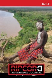
broke the silence. “That is the Omo Valley.”<br />
Much lay in wait in this valley in the south-west of Ethiopia<br />
bordering Sudan and Kenya – a place where people of different<br />
tribes scar, paint and pierce their bodies, where women are publicly<br />
whipped to demonstrate their loyalty, and where men run naked<br />
across bulls to prove their manhood. We returned to the maroon<br />
and silver Nissan Patrol to bump and skid along the dirt roads that<br />
kicked clouds of dust in our wake. It was the first of many similar<br />
journeys during the forthcoming week.<br />
We had travelled for perhaps a couple of hours, the sameness of the<br />
scenery dulling the sense of time, when suddenly on our right side<br />
appeared a collection of two dozen sizable wooden huts within a<br />
spacious clearing. It was a village of the Arbore tribe. Once out of<br />
the vehicle, I encountered a practice that elicits much debate<br />
amongst those who visit the Omo Valley – namely the payment of a<br />
fee to take photographs. The problems of this practice quickly<br />
became evident. Upon our arrival, the Arbore people rushed from<br />
their huts to form a long line near the vehicle hoping to be chosen,<br />
and paid, to be photographed. It felt incredibly forced, and though I<br />
am unsure where this practice emanated from, obediently lining in<br />
an orderly fashion was inconsistent with every other activity I<br />
witnessed in the Omo Valley. This appeared imposed from outside.<br />
I lowered my head, undecided if I wanted to participate in this<br />
awkward spectacle, but there was no retreat, for the Arbore would<br />
aggressively pursue those with cameras to photograph them. They<br />
would grab your arm or camera and verbally badger for a picture;<br />
this whirlwind of activity and attention was almost overwhelming. I<br />
wandered far away from the scene with one Arbore woman in order<br />
to distance myself from the selection line, which on further<br />
reflection, looked more and more like a circus with paid performers.<br />
By having her with me, it seemed to keep the others away, but that<br />
only lasted until she dawdled away after the photo shoot, for the<br />
chaos descended on me again.<br />
13
The Tribes that time forgot<br />
Text & Images By Shane Dallas<br />
After a difficult photography session, I returned to the vehicle – and<br />
upon closing the door found myself inside a serene silent shelter<br />
from the buffeting verbal tempest outside. My first tribe visit<br />
proved to be a confronting experience. In 2010, the payment<br />
amounts were small, one or two Birr (approximately 15 cents at the<br />
time), whereas a larger amount (at least 250 birr) is payable as a<br />
village admission fee. However, these prices have increased many<br />
times over since then.<br />
AAAAAAAAAAAAAAAAAAAAAAAAAAAAAAAAAA<br />
AAAAAAAAAAAAAAAAAAAAAAAA<br />
While still musing on the most responsible method to approach<br />
photography in the Omo Valley, we proceeded to the small town of<br />
Turmi. Our plans to arrive in the late afternoon were thwarted by<br />
the road conditions. Shortly after Tsegay had changed a tyre due to<br />
a puncture, he leaned out of the window and muttered something<br />
under his breath before stopping to attend to the second puncture in<br />
the space of half an hour. With little phone coverage and almost no<br />
traffic in this part of the Valley, any serious vehicle issues would<br />
cause immense problems. Since we now had no spare tyres, a third<br />
puncture would leave us stranded.<br />
The journey through a terrain of trees upon sandy soil continued<br />
after sunset, and the surrounding scene was one of absolute<br />
darkness. The vehicle’s headlights were the only source of<br />
illumination on this landscape devoid of any other light source –<br />
nothing coming from huts, none marking any streets, and no other<br />
vehicles. Avoiding any further punctures, we arrived in the small<br />
town of Turmi, and the faint orange glow of the occasional street<br />
light enabled me to discern a town comprised of a single road<br />
populated with squat flat-roofed buildings on either side of the<br />
carriageway.<br />
Our late arrival on a cool evening in Turmi meant that<br />
accommodation was limited to the diabolical Green Hotel. If one<br />
considered that the hotels of the world formed a human body, and a<br />
doctor needed to give this collective body an enema, then they<br />
would insert it into the Green Hotel. It is the foulest place I have<br />
ever stayed in, the one remaining room was small, stuffy with<br />
peeling green paint and a broken fly screen that allowed entry to<br />
malaria-carrying mosquitoes. The linen was a public health risk and<br />
14
AAAAAAAAAAAAAAAAAAAAAAAAAAAAAAAAAAAAA<br />
AAAAAAAAAAAAAAAAAAAAAAAAAAA<br />
The Tribes that time forgot<br />
Text & Images By Shane Dallas<br />
as an added feature of this five dollar room, it held a complimentary<br />
pile of condoms, some opened. These were obviously used by the<br />
clients of the women who frequented the nearby bar whose music<br />
reverberated through the entire room. Though the music finally<br />
ceased at 1 am, it was followed by a frightful fight between highly<br />
inebriated women who charged by the hour and their equally<br />
drunken clients.<br />
After a broken sleep and pitiful breakfast, happiness again returned<br />
when I saw the Green Hotel disappear in the rear-view mirror.<br />
With both punctured tyres now repaired, two hours of driving<br />
along moderately good roads saw our arrival in the small town of<br />
Omorante, only 40 kilometres from the Sudanese border. It was a<br />
very warm and dusty place where people languidly shifted along the<br />
roads lined with forlorn shops, whilst goats and other animals<br />
occupied themselves in the search for food.<br />
After registering at the police station, there was a choice of two<br />
hotels, one dire, the other dismal. As with most accommodation in<br />
the Omo Valley, the toilets were fetid, the showers cold, and the<br />
food average. The latter was the biggest disappointment, for<br />
Ethiopia has an excellent cuisine – arguably the best in Africa – but<br />
sadly, that quality was absent in the Omo Valley. The main reason to<br />
visit Omorante was to cross the Omo River to visit the Galeb tribe.<br />
However, my desire for embarking on this short voyage quickly<br />
evaporated when watching the elongated and unstable boats carved<br />
from a single tree plying the fast flowing Omo River. The boatmen<br />
were obvious masters of their craft for they would direct the boat<br />
close to the steep river bank some distance upstream before<br />
swinging to the centre of the river and being hurtled downstream<br />
whilst crossing to the other side. Even an experienced swimmer like<br />
me would have trouble surviving in those treacherous waters in the<br />
case of a capsize. Some adventures are best left for another time.<br />
So far the expedition to the Omo Valley had been beset by barriers<br />
and difficulties with meagre rewards – it had been an inauspicious<br />
start to the adventure. Thankfully, the situation improved on the<br />
third day when Tsegay drove me to a village called Kolcho inhabited<br />
15
16
17
The Tribes that time forgot<br />
Text & Images By Shane Dallas<br />
by the Karo tribe. Our vehicle encountered the roughest dirt road<br />
conditions of this journey, and we occasionally needed to navigate<br />
around gaping holes that threatened to swallow the vehicle and<br />
manoeuvre past almost vertical declivities – Tsegaye’s driving was<br />
superb.<br />
We passed a naked man standing on a sandy dry riverbed<br />
overlooking the few cattle in his possession. His lean dark frame<br />
stood motionless, supporting himself on the long stick which he<br />
held in one hand. There was not even a hint of modernity in this<br />
scene that could have occurred thousands of years ago, rather than<br />
in the 21st century.<br />
AAAAAAAAAAAAAAAAAAAAAAAAAAAAAAAAAA<br />
AAAAAAAAAAAAAAAAAAAAAAAA<br />
After much jarring of bones and inhaling of dust, we arrived at<br />
Kolcho nestled near to a stunning lookout with a magnificent grand<br />
and wide panorama over the Omo River far below. This was one<br />
village worthy of an entrance fee, for not only were the views<br />
impressive but so too was the village. Covering a large area with a<br />
multitude of large huts that were relatively densely packed, it was a<br />
tremendous place to explore the numerous paths that meandered<br />
between the habitations.<br />
The Karo are a very pleasant people, it was possible to walk around<br />
unaccompanied and receive only occasional, polite requests for<br />
photographs. In this village with neither electricity nor water<br />
supply, I could quietly observe Karo pastoral life; women would<br />
grind grains for dinner and larger children would play with their<br />
younger and smaller siblings by sitting them on a large piece of<br />
metal and drag them along at speed. It was an idyllic scene of<br />
simple and unaffected contentment. The Karo people deserved their<br />
title as the region’s best body painters as they sported elaborate and<br />
full decorations but the reason for this artistry was never fully<br />
explained to me, apart from the obvious atheistic and decorative<br />
aspects.<br />
I was sauntering around the village when someone behind me spoke<br />
in perfect English “How are you?” I had not sighted another<br />
foreigner but could have been mistaken since there were so many<br />
huts where one could loiter unseen. So imagine my surprise when I<br />
18
19
The Tribes that time forgot<br />
Text & Images By Shane Dallas<br />
turned to see a Karo woman with a painted face and numerous<br />
necklaces squatting by her modest hut. She only spoke a few words<br />
of English but was the only person who was able to communicate<br />
with me verbally. For everyone else, it was via gestures and the<br />
international language of a smile.<br />
One vividly painted Karo warrior and I formed a particularly strong<br />
bond. Proudly carrying his automatic weapon, and with a red tinge<br />
in his eyes that were accentuated by his white painted face, I showed<br />
him images of other tribes which seemed to interest him greatly. He<br />
posed for numerous photographs and we shared a smile and laugh<br />
whilst reviewing the images. When it came time to depart, he gave<br />
me a genuinely emotional farewell, I could discern it in his eyes. He<br />
did not want me to leave, and I felt the same way. There was so<br />
much more to learn from him about his life and his village. It is<br />
heartening to know that genuine warmth can be established between<br />
people from extremely different cultures and different languages<br />
within a brief time.<br />
AAAAAAAAAAAAAAAAAAAAAAAAAAAAAAAAAA<br />
AAAAAAAAAAAAAAAAAAAAAAAA<br />
We returned to Turmi and I decided to pay a relative premium for a<br />
spacious cabin at the Evangadi Lodge with cold showers and a toilet<br />
that did not make me shudder. This Monday was a special day in the<br />
town, for not only was it market day, but a Hamer initiation<br />
ceremony would occur later that afternoon. The Hamer people are<br />
famed throughout Ethiopia, their beautiful women plat their hair<br />
and coat it with a distinctive red clay, and the men are equally<br />
handsome. I warmed to the Hamer tribe more than any other, they<br />
were gentle and a smile never seemed far away.<br />
The market was the best in the Omo Valley, as hundreds of Hamer<br />
converged to interact and trade goods in an expectedly relaxed<br />
environment. I espied a few women with large, wide scars on their<br />
backs and arms, which I thought odd for a seemingly placid people.<br />
It felt surreal to watch this glimpse of tribal life and it was not the<br />
only time this journey that felt as if I had stumbled into the middle<br />
of a National Geographic documentary.<br />
After losing track of time, I needed to hurry to attend the Hamer<br />
initiation ceremony, one of the highlights of any Omo Valley visit.<br />
20
AAAAAAAAAAAAAAAAAAAAAAAAAAAAAAAAAAAA<br />
AAAAAAAAAAAAAAAAAAAAAAAAAA<br />
The Tribes that time forgot<br />
Text & Images By Shane Dallas<br />
This ceremony is an elaborate affair which allows the male initiate,<br />
if successful, to commence the process of choosing a wife. The<br />
ceremony lasts hours and commences with women adorned in<br />
bangles and carrying small noisy horns, jumping in unison and<br />
following each other in a tight circle. This celebration is not so<br />
unusual, but the same could not be said of the public whipping that<br />
followed.<br />
Tradition dictates that any relative of the initiate can prove their<br />
loyalty by being publicly scourged with a thin, destructive whip.<br />
The process involves a woman approaching any Hamer adult male<br />
to deliver the punishment, but some men were reluctant to take<br />
part, and they had less enthusiasm for the practice than some of the<br />
women who needed to cajole them for another lashing. Supposedly<br />
a woman will plea to a man “Hit me,” he will respond “No,” and<br />
her retort being “You are no better than a woman!” at which time<br />
she would receive a single strike. Some women proudly displayed<br />
numerous open welts on their back, but not every female was<br />
similarly enraptured by the societal pressure. I espied a forlorn<br />
teenager with doleful eyes who had just received her first whipping;<br />
I pointed to a long thin cut on her back and she expressed her<br />
feelings by grimacing.<br />
While the women bravely bore their wounds in silence, the men<br />
continued the ceremony by engaging in ritualistic face painting – a<br />
rather genteel task compared to what the women endured. Most<br />
memorable was that the packed group of men squatting in the shade<br />
of an enormous tree were so incredibly intense. The concentration<br />
of the painters’ faces was immense, but it paled when compared to<br />
the recipients, whose eyes were simultaneously both calm and<br />
fervent; the gaze of men searching their inner thoughts as if in a<br />
trance.<br />
The gathered crowd walked the one kilometre along a dirt road for<br />
the climax. Whilst the Hamer men gathered around the initiate in a<br />
tight huddle, twelve reluctant bulls from a collection of much more<br />
were forcibly placed beside each other in a line, as the women<br />
danced, jingled and played their horns around the corralled beasts.<br />
Some of the beasts almost broke free to wreak havoc on their<br />
21
22
23
The Tribes that time forgot<br />
Text & Images By Shane Dallas<br />
handlers, but they were thankfully subdued. With scores of men<br />
holding the bulls in place under cloudy skies, the naked initiate<br />
stood at the far end as the women increased their noise to a<br />
crescendo and the tourists paused with cameras poised. Suddenly<br />
the initiate leapt onto the first bull and quickly, but ever so carefully,<br />
stepped on each animal before jumping on the ground near me, at<br />
which time I detected his expression of absolute concentration<br />
flicker for a moment to one of momentary relief. He returned from<br />
whence he came, again stepping on each of the bulls, and he<br />
repeated this whole process two more times. It took less than a<br />
minute for the initiation to be successfully completed and the<br />
foreigners applauded, which seemed incongruent for this traditional<br />
ceremony.<br />
The assembled onlookers dispersed and when leaving the area we<br />
offered a seat in our vehicle to a Hamer teenager, his youthful dark<br />
face a stark contrast to his shining white teeth. He saw me reviewing<br />
the images on my camera and requested to see the picture of the<br />
naked initiate crossing the bulls.<br />
I showed him the picture, and he asked me, “Get closer,” so I<br />
zoomed into the initiate alone.<br />
The teenager looked at the body and commented. “He is a strong<br />
man, and has a strong gun...” which referred to the size of the man’s<br />
genitalia, “he will have good children.”<br />
He looked away from the camera before stating, “My initiation<br />
ceremony will be soon.”<br />
“Really, that is great news,” I replied, “When will it be?”<br />
He paused before answering, “In a few weeks. I do not know the<br />
day.”<br />
“Will it be a big ceremony like this one?” I enquired.<br />
“No, a small one. There will be no women, only men,” he stated.<br />
24
AAAAAAAAAAAAAAAAAAAAAAAAAAAAAAAAAAAAA<br />
AAAAAAAAAAAAAAAAAAAAAAAAAAA<br />
The Tribes that time forgot<br />
Text & Images By Shane Dallas<br />
“Will there any faranjis?” I asked, that being the local word to<br />
describe foreigners.<br />
“No, only the men of my tribe.”<br />
“So you can choose if you want a big or small ceremony.”<br />
“Yes I can. I will have a small ceremony. Not many people.”<br />
We had arrived at my hotel, “I wish you the best for the ceremony.”<br />
“Thank you,” he responded by flashing that brilliant white smile<br />
and he exited the vehicle.<br />
The only town of note in the Omo Valley is Jinka, it even had<br />
mobile phone coverage. As we approached I remember hearing that<br />
Jinka once had an airport used for regional flights, so I asked Tsegay.<br />
“Did Ethiopian Airlines used to fly to Jinka?”<br />
“Yes, but they stopped it not long ago.”<br />
“Why?”<br />
Tsegay gave me one of those of his typical wry smiles. “You will<br />
know when you see the airstrip.”<br />
And sure enough I did, for there in the middle of Jinka’s low rise<br />
buildings sat what was once the airport, the former airstrip an<br />
uneven surface now populated with animals grazing on tufts of<br />
grass. Any plane landing on this surface, even without the grass and<br />
bovines, would be a risky venture.<br />
“Now you see why,” stated Tsegay.<br />
I laughed and nodded in reply.<br />
Rambling around the dirt streets one late afternoon, many friendly<br />
25
26
27
The Tribes that time forgot<br />
Text & Images By Shane Dallas<br />
people approached me who keenly wished to talk and swap stories.<br />
So many were interested in my country of origin, and what I<br />
thought of Ethiopia and the Omo Valley. When the sunset’s scarlet<br />
light painted the buildings with its soft hue, I returned to my room<br />
where I saw my reflection in a mirror for the first time in many days<br />
and was surprised at my gaunt appearance. Subconsciously I had<br />
reacted to the poor state of the food and the worse state of the<br />
toilets by eating little, thus allowing me to minimise my exposure to<br />
both.<br />
AAAAAAAAAAAAAAAAAAAAAAAAAAAAAAAAAA<br />
AAAAAAAAAAAAAAAAAAAAAAAA<br />
Jinka was the base to meet the most famous and feared tribe in the<br />
Omo Valley; the aggressiveness of the Mursi is known by many, and<br />
some travellers have refused to visit due to episodes such as stone<br />
throwing and their predilection for alcohol. However, this<br />
promised an unforgettable experience, so undaunted we proceeded<br />
to the Mago National Park where the tribe resides. A sign at the<br />
park’s entrance states No Automatic Weapons, but this regulation is<br />
flagrantly ignored by the Mursi.<br />
At the final checkpoint we were required to acquire the services of<br />
an armed guard, and whilst organising this service, we met a<br />
departing group of half a dozen European tourists who had stayed<br />
with the Mursi the previous evening.<br />
“How was your night?” I asked a young unshaven man.<br />
He glanced at me with weary eyes. “It was...difficult. I had very<br />
little sleep,” as he turned and walked away. That was not reassuring.<br />
With the armed guard sitting beside me in the now dirt encased<br />
Nissan Patrol, we encountered another potential peril. Apart from<br />
the Omo Valley’s malarial mosquitoes, the park is home to the<br />
Tsetse Fly that can inflict a most painful bite. When one of these<br />
brightly coloured insects appeared in the cabin near to the guard, he<br />
became most anxious and feverishly waved his hands and gun in the<br />
air. An agitated armed guard is never a good situation, regardless of<br />
the cause.<br />
I harboured nervousness about visiting the Mursi and the portent of<br />
28
AAAAAAAAAAAAAAAAAAAAAAAAAAAAAAAAAAAAA<br />
AAAAAAAAAAAAAAAAAAAAAAAAAAA<br />
The Tribes that time forgot<br />
Text & Images By Shane Dallas<br />
silence within the vehicle reflected my thoughts. This concern was<br />
well founded, for we came upon a Mursi village to scenes of<br />
frenzied activity as two vehicles with a dozen tourists had already<br />
arrived, and the Mursi were swarming around them like a pack of<br />
sharks closing in for a kill. Women were particularly aggressive in<br />
physically seizing people for a photograph.<br />
“This is not good,” I sighed to Tsegay.<br />
“No, it’s not,” came his stoic reply, as we watched another tourist<br />
disappear behind a mass of gesticulating Mursi women.<br />
“Is it always like this?” I questioned.<br />
Tsegay nodded and quietly uttered, “Yes.”<br />
“Maybe we should wait until the other faranji leave?”<br />
“A good idea,” concurred Tsegay.<br />
Tsegay reversed the car and we observed tourism’s ugly side from a<br />
distance. We hoped that it would be calmer once these groups had<br />
departed, and thankfully this prediction proved correct. Once<br />
within the small village with the simplest of huts, we noticed the<br />
ubiquitous presence of automatic weapons, even the women carried<br />
them, a practice considered abhorrent by other tribes. The reason<br />
for this convention was difficult to determine, it was either deemed<br />
necessary for protection against predators, or possible against other<br />
Mursi. This was even more confronting than the Arbore tribe, for<br />
when someone grabs your arm demanding a photo be taken, and<br />
they have an AK47 swinging from their arm, it does change the<br />
power balance of the situation strongly against the visitor.<br />
Communicating with the tribe was protracted as conversations<br />
needed to be translated from Mursi to the national Amharic<br />
language (courtesy of the armed guard) and from Amharic into<br />
English (courtesy of Tsegay) so these stilted colloquies involved not<br />
only the Mursi and me but two interpreters as well. Like much of<br />
the Omo Valley, it was difficult to garner a fuller understanding of<br />
29
30
31
The Tribes that time forgot<br />
Text & Images By Shane Dallas<br />
the people due to the language barrier, and the Omo Valley contains<br />
many languages, each only spoken by a few thousand people. But<br />
this communication, however protracted, did make a difference to<br />
our visit – when the Mursi knew we wished to learn more about the<br />
village and its people, their reaction changed. Many returned to<br />
their usual daily duties instead of focusing their energies on our<br />
presence. As the previous group discovered, heading into any tribe<br />
for a whirlwind stop just to photograph receives a less welcoming<br />
reaction than those who are prepared to linger and learn.<br />
AAAAAAAAAAAAAAAAAAAAAAAAAAAAAAAAAA<br />
AAAAAAAAAAAAAAAAAAAAAAAA<br />
The body decoration on the Mursi was superb, and the scarification<br />
used by both men and women tended towards the elaborate.<br />
However, the iconic image of the Omo Valley is that of the lip plate<br />
worn only by the women, and they vary in size from moderately<br />
small to more than 20 centimetres wide. This adornment is not<br />
universally utilised, but the women who chose to do so consider it<br />
an object of beauty. For those who choose to wear one, they start<br />
with smaller plates in their teenage years until reaching full-sized<br />
plates in adulthood. The plate, which has a groove around the edge<br />
where the extended lip is placed, is not worn continuously as the<br />
wearer will remove it when eating or sleeping, nor are they worn<br />
when visiting the Jinka markets as the Mursi believe that these plates<br />
appear odd to outsiders.<br />
We departed 90 minutes later, but I was disappointed by my poor<br />
reaction to the Mursi’s initial aggressiveness that allowed me to be<br />
overwhelmed for a second time on this journey. I vacillated on<br />
whether to return to the Mursi tribe the next morning. My<br />
photographs on the first visit were quite poor, my creativity<br />
bludgeoned by the intense environment. Perhaps a return was in<br />
order, and despite knowing that it would be another confrontational<br />
experience, not visiting again would be a regret.<br />
Thus, with a greater mental preparedness, we returned to two<br />
different Mursi villages. These were both smaller, received fewer<br />
tourists and hence less frenzy. It was such a calm contrast to the<br />
previous day. The more relaxed mood allowed me to capture better<br />
photographs, and even the sternest visage would lighten and<br />
sometimes laugh upon seeing their picture on my camera’s LCD<br />
32
The Tribes that time forgot<br />
Text & Images By Shane Dallas<br />
screen. It was a pleasant conclusion to my tribal visits in the Omo<br />
Valley and showed that generalisations about a people never account<br />
for the nuances that they, both as an individual and a collective, can<br />
possess.<br />
As we embarked on the three-day journey to Ethiopia’s capital of<br />
Addis Ababa, it allowed me to reflect on the oft-described vanishing<br />
tribes of the Omo Valley. These tribes as so distinct that one could<br />
determine their identity by merely looking at clothing and body<br />
adornments, but how do these tribes retain their cultures?<br />
Tourism’s negative impact includes photography payments and I<br />
was part of the problem by ceding to such. Visiting tribes where<br />
people stand in line hoping to be chosen to be photographed was<br />
most uncomfortable for all concerned.<br />
But tourism can both destroy and preserve. The Omo Valley seems<br />
to retain its culture better than many places; at least the tribes realise<br />
that their traditional lifestyle and culture provide an income, and<br />
this income encourages them to maintain their identity, even if it is<br />
at the cost of avarice. However, I sighted people in traditional tribal<br />
attire far away from the tourist path, so even without income from<br />
tourism, many of these practices would remain.<br />
As Tsegay drove the vehicle out of the valley, we sighted a new<br />
bitumen road being constructed. It would make the journey<br />
between Jinka and the major town before the Omo Valley, Konso,<br />
much easier and faster. Development was coming to Omo Valley<br />
and as we passed groups of workers huddles around massive<br />
machinery, I wondered with trepidation what would be the impact.<br />
Perhaps, time will not forget these tribes any longer.<br />
The completion of that road changed the Omo Valley, for the easier<br />
passage not only meant better access to health care and trading but<br />
also meant an influx of foreign visitors who would not undertake<br />
the journey on rougher roads. One sincerely hopes that these tribes<br />
which have filled the Omo Valley with their richness for millennia<br />
can continue to retain their identity and thrive within a truly<br />
remarkable wooded valley.<br />
www.thetravelcamel.com<br />
33
A Call To Adventure<br />
34<br />
Megan<br />
Hine<br />
<strong>RAJ</strong> 1.3
AAAAAAAAAAAAAAAAAAAAAAAAAAAAAAAAAAAAA<br />
AAAAAAAAAAAAAAAAAAAAAAAAAAA<br />
A call to adventure<br />
By Megan Hine<br />
I am proud to stand amongst the ranks of mountain and wilderness<br />
professionals, the silent corps with the thousand-mile stare. Gazing<br />
towards future adventures, dreaming of remote places, living and<br />
breathing the outdoors. We follow in the wake of the great<br />
explorers, the trailblazers, the likes of Shackleton, Hillary,<br />
Amundsen, the explorers and pioneers of a bygone era, discovering<br />
and settling new lands. Those incredible humans who lit the flame<br />
of exploration and pushed the boundaries of human imagination.<br />
In all of us there glows a residual ember of this time of exploration,<br />
a dull need inside to push boundaries and discover new horizons, to<br />
fight for survival. This ember sits waiting for the draft of inspiration<br />
and opportunity to fan it into a burning passion.<br />
For some of us this flame burns bright, ever threatening to consume,<br />
we need to feed it with experiences and travel, it makes us restless<br />
and drives us towards new goals. It pushes us, ever onwards,<br />
searching for the next big hit, for moments of pure clarity, those<br />
moments of flow where the self and nature are one, the body lost to<br />
the rock or to the trail we climb or run. For me, I find this in the<br />
wildest of places. The endless horizons offer a multitude of<br />
possibilities and a hefty dose of adrenalin draw me in.<br />
There is nothing more satisfying to me than pushing myself to the<br />
edge of what I thought was physically, mentally and emotionally<br />
possible. Like surfing on the peak of a breaking wave, nothing<br />
makes me feel more alive or connected to the world.<br />
I am privileged now to be able to share this with others, to take<br />
them by the hand and lead them over the threshold and into the<br />
wild. To help them to face their own challenges and to overcome<br />
hurdles they never thought possible. Watching people change in the<br />
wilderness and build confidence in themselves and their decisions,<br />
seeing that spark ignite, and their lives take on a whole new meaning<br />
is such an incredible experience to share.<br />
Somebody expressed recently to me their admiration for my<br />
adventures and how they wished they could be more adventurous<br />
but lacked the confidence. This struck a chord with me, there must<br />
35
A call to adventure<br />
By Megan Hine<br />
be others, others whose image of themselves and what is ‘normal’<br />
stops them from following their heart. Their dreams weighing them<br />
down, the frustration and failure they must feel in not being able to<br />
answer the call. It is so often our own self that limits our<br />
possibilities, creating barriers of self-doubt, seemingly impossible to<br />
overcome.<br />
Stop waiting, stop dreaming of ‘what ifs’! A whole world awaits<br />
you! Adventure isn’t just summiting the towering, snow-capped<br />
peaks or kayaking the gnarliest of falls. Adventure is subjective, it is<br />
what drives you and what calls to you, it is different in each of us.<br />
I love reading articles of passion from people pushing their own<br />
personal boundaries and what this means to them. For them, their<br />
achievements equate to summiting their own, personal Everest. I<br />
have as much respect for the first time traveller as the seasoned. For<br />
those brave enough to take their first forays to discover themselves<br />
and their dream I salute you.<br />
This is a call to all of you dreamers, you ‘wannabe’ adventurers!<br />
Come stand shoulder to shoulder with us, bring your dull ember<br />
and let us help you to find the inspiration and opportunity to ignite<br />
it into flame.<br />
Let us share our knowledge with you, discover new horizons and<br />
give you the confidence to believe in yourself and to turn those<br />
dreams into reality.<br />
www.meganhine.com<br />
36
37
Sistema Huautla<br />
38<br />
Bill<br />
Steele<br />
<strong>RAJ</strong> 1.4<br />
Images © Chris Higgins
AAAAAAAAAAAAAAAAAAAAAAAAAAAAAAAAAAAAA<br />
AAAAAAAAAAAAAAAAAAAAAAAAAAA<br />
Sistema Huautla: Fifty Years of Continuous Exploration<br />
By C. William Steele<br />
In the summer of 1965 three young Texas weekend spelunkers<br />
drove a low riding car up a newly constructed dirt road in the Sierra<br />
Mazateca of the northern part of the southern Mexico state of<br />
Oaxaca. They were seeking caves with the potential to be the<br />
deepest in the Americas. They had it right. As soon as they got in<br />
the vicinity of Huautla de Jimenez, they started finding cave<br />
entrances.<br />
The next year they returned with ropes and drove to the other side<br />
of the mountain town of Huautla. Immediately they found two<br />
large cave entrances in the bottom of deep sinkholes. These are the<br />
primary entrances of Sistema Huautla, a mega cave system with 20<br />
entrances, 71.4 km (44 miles) in length, 1,554 m (5,097 feet) in depth,<br />
making it the deepest known cave in the Western Hemisphere, the<br />
8th deepest cave in the world, the longest of the 16 deepest caves in<br />
the world, and what many cavers feel is the greatest cave on Earth.<br />
Fifty years later, over thirty expeditions, seven of them Explorers<br />
Club flag expeditions, this exploration of these caves has renewed<br />
momentum. Late March to early May 2015 forty-seven speleologists<br />
from seven countries: USA, Mexico, Great Britain, Australia,<br />
Poland, Switzerland, and Romania participated in a six-week<br />
expedition in varying lengths of stay. There was a long list of<br />
objectives, including exploring unexplored passages by “checking<br />
out leads” indicated in past underground survey field notes.<br />
The restarted project exploring and studying the caves of the<br />
Huautla de Jimenez, Oaxaca, Mexico has been given the name of<br />
Proyecto Espeleologico Sistema Huautla (Huautla system<br />
speleological project), or PESH for short. PESH was launched in<br />
2013 with the objectives of extending the mapped length of the cave<br />
system from the then 65 km to over 100 km, the depth from the<br />
current 1,554 m to 1,610 m (a vertical mile, or 5,280 feet), and all the<br />
while maintaining “full speleology”, meaning studies and papers<br />
written on the various study disciplines of speleology: geology,<br />
hydrology, biology, paleontology, archaeology, and exploration<br />
techniques.<br />
The exploration of the Huautla caves has gone through phases. The<br />
39
Sistema Huautla: Fifty Years of Continuous Exploration<br />
By C. William Steele<br />
years 1965-1970 saw several expeditions organized by cavers from<br />
the USA and Canada, and the establishment of the cave Sotano de<br />
San Agustin as the deepest cave in the Americas at 600 m in depth. It<br />
was felt that the cave was fully explored.<br />
In 1976 a group went to see this cave and check out a “lead”<br />
indicated on the map published by the Canadians a few years<br />
before. In caving jargon, a “lead” is a possible unexplored passage.<br />
A lead is indicated on a cave map with broken continuing lines and a<br />
question mark. Maybe it goes on, and maybe it doesn’t. The reason<br />
the lead had not been entered eight years before was that it was very<br />
remote, taking two days of underground travel to get to it, and there<br />
was a very difficult overhung climb about five meters high. This<br />
climb was successfully climbed, a passage did indeed continue, and<br />
since then the cave has been explored from a length of two miles<br />
then to 44 miles now and the depth is two and a half times deeper.<br />
AAAAAAAAAAAAAAAAAAAAAAAAAAAAAAAAAA<br />
AAAAAAAAAAAAAAAAAAAAAAAA<br />
After the 1976 expedition there was one expedition after another<br />
most years until 1994. The 1994 expedition was a major three<br />
month-long effort that resulted a book being written about it,<br />
“Beyond the Deep”. The farthest the 1994 expedition reached was a<br />
deep pool of water at a depth of 1,475 m below the highest point<br />
reached in the cave system. The pool was extremely remote and<br />
required not only hundreds of meters of technical rope work, but<br />
long dives underwater too, with rebreathers and sophisticated scuba<br />
gear, and camping in the cave beyond the reach of any means of<br />
communication with the surface.<br />
Between 1994 and 2007 there were a few scattered expeditions to the<br />
Huautla caves, but several of those years saw no activity. The<br />
Huautla cavers were exploring caves elsewhere in Mexico, USA,<br />
China, Puerto Rico, etc.<br />
Then came 2013 and the big British-led expedition. Young, very<br />
active, British cave explorers sought logistical information from me<br />
and others to mount their own expedition to dive in the deep pool,<br />
called a “sump” in caver parlance, at the bottom of the cave.<br />
Through the years leading up to this expedition Sistema Huautla<br />
had been surpassed in depth by a cave not far south of it, on a high<br />
40
Sistema Huautla: Fifty Years of Continuous Exploration<br />
By C. William Steele<br />
mountain range separated from the Huautla plateau by a deep<br />
canyon, and this cave, Sistema Cheve, had a surveyed depth only<br />
nine meters deeper than Sistema Huautla.<br />
The Brits had a successful expedition and explored 80 m deep in the<br />
pool of water, using mixed gases for breathing. Eighty meters was<br />
the limit what they could do with the gases they were breathing so<br />
they ended the dive there, with the water-filled passage descending<br />
at least another 20 meters they could see with powerful underwater<br />
dive lights. Sistema Huautla was once again the deepest cave in the<br />
Western Hemisphere at 1,554 m from the highest point humanly<br />
reached in the cave, to the lowest point humanly reached. That’s the<br />
way it’s figured in a deep cave.<br />
Tommy Shifflett from Virginia and I joined the British expedition<br />
for the last part of it. We had our own<br />
area to look at, looking for unexplored passages, and found over<br />
half a kilometer of lovely decorated, unexplored passages after<br />
doing an aid climb across the top of a shaft.<br />
Tommy and I talked while we were there together about how much<br />
we love the caves and the area of Huautla, Oaxaca, and there is<br />
much remaining to do. So, in the airport in Oaxaca, as we waited<br />
for our respective flights back to the USA, we sketched out a plan<br />
for a restart of annual expeditions to Sistema Huautla and other<br />
caves of the area.<br />
We decided to give our project a new name – in Spanish this time –<br />
Proyecto Espeleologico Sistema Huautla, and wrote down our<br />
goals:<br />
To explore, survey, and conduct a comprehensive speleological<br />
study of the Sistema Huautla area caves.<br />
Conduct speleological studies to include exploration and mapping,<br />
cartography, geology, hydrology, biology, paleontology,<br />
archaeology, and equipment and technique development.<br />
Support Mexican cave scientists in field research.<br />
41
Sistema Huautla: Fifty Years of Continuous Exploration<br />
By C. William Steele<br />
Conduct annual springtime expeditions for ten years 2014-2023 .<br />
Survey data kept current.<br />
Goal of reaching 100 km in length.<br />
Goal of reaching 1,610 m in depth, which is 5,280 ft., a vertical<br />
mile.<br />
All results published.<br />
All of this is easy to say, but to say we’re going to have annual<br />
expeditions for ten years, it’s very important that the first one be<br />
successful. The first PESH expedition, in 2014, was successful on<br />
several fronts. Diplomacy at the state, municipio, and agencia levels<br />
was for the most part fruitful, with permission granted to go caving<br />
in the area for three years. One area remains a challenge due to the<br />
resident Mazatec people’s beliefs in cave spirits and what might<br />
happen if they are angered by foreigners going in caves no one has<br />
ever entered. A plan has been formulated to do diplomatic work to<br />
deal with this issue, but it’s going to take several years to overcome,<br />
if it’s ever overcome.<br />
The area to the east of the known passages of Sistema Huautla, was<br />
an objective, to search for new cave entrances that might descend<br />
deep and connect with the cave system below. Around 20 new pits<br />
and caves were explored and mapped, without anything going very<br />
far or deep. A cave southeast of known passages in the system<br />
shows promise with strong airflow and the exploration of it will<br />
continue during the 2016 expedition.<br />
Oscar Franke, Ph.D., professor of biology, a noted arachnologist<br />
and scorpion expert and a professor at the National Autonomous<br />
University of Mexico (UNAM) in Mexico City, joined our<br />
expeditions in 2014 and 2015 and brought along three graduate<br />
students each time. They are thrilled that they have collected twelve<br />
new species of cave life, including new species of tarantula, new<br />
species of harvestmen spiders, and a new species of scorpion in the<br />
caves. They will return in 2016.<br />
42
43
44
AAAAAAAAAAAAAAAAAAAAAAAAAAAAAAAAAAAAA<br />
AAAAAAAAAAAAAAAAAAAAAAAAAAA<br />
Sistema Huautla: Fifty Years of Continuous Exploration<br />
By C. William Steele<br />
An important paleontological site was found in a cave as well. In a<br />
series of large adjoining rooms in a cave we had not visited in over<br />
30 years, not far from the village where we rent houses, large bones<br />
were noticed in a talus cone of dirt on the floor. We think there must<br />
have been an entrance above the bones at one time in the distant<br />
past. Based on photographs taken with scale and sent to a<br />
professional paleontologist in Mexico City, he feels that at least one<br />
of the animals is an extinct Pleistocene ground sloth. A graduate<br />
student of his joined us for a week this year and plans to return for a<br />
longer amount of time in 2016 to excavate the 1 ½ m tall cone of<br />
bones and other ancient surface debris.<br />
Halfway through the first PESH expedition in 2014, five cavers<br />
arrived with packs already prepared to go underground and camp in<br />
the La Grieta section of Sistema Huautla. La Grieta, meaning “the<br />
crack”, is a significant section of Sistema Huautla. It’s over 700 m in<br />
depth to where it connects to the system and has tributaries feeding<br />
into it that were initially explored in 1977, but no one had been back<br />
to them since then.<br />
Taking underground backpacks, five cavers went into La Grieta to<br />
stay underground for nine days. They set up a remote camp and<br />
explored an upstream tributary initially explored without finding an<br />
end in 1977. They succeeded in discovering and mapping 1.6 km of<br />
new passages. This was Kasia Biernacka of Poland, Gilly Elor,<br />
Corey Hackley, John Harman, and Bill Stone of the USA. Three of<br />
them camped underground for seven days and two of them for nine.<br />
Their most significant discovery was a passage extending over 1.5<br />
km to the north, directly toward the highest topography in the area.<br />
They turned around in 20 X 20 m borehole passage because they<br />
were running low on food and battery power for their lights. This<br />
continuing passage is a major objective for 2016.<br />
The second annual PESH expedition took place from March 23 –<br />
May 5, 2015 with 47 speleologists and support people from ten<br />
counties; the United States, Mexico, England, France, Germany,<br />
Poland, Switzerland, Austria, Romania, and Australia.<br />
Cavers explored the upstream sump (a sump is a cave passage with<br />
45
Sistema Huautla: Fifty Years of Continuous Exploration<br />
By C. William Steele<br />
water to the ceiling (necessitating scuba gear) in Red Ball Canyon at<br />
the 700 m (2,296 foot) deep Sotano de San Agustin section of<br />
Sistema Huautla, an area not seen since 1979. On the far side of<br />
three sumps, 30 m, 30 m, and 5 m long, two cavers, Andreas<br />
Klocker of Australia, and Zeb Lilly of Virginia in the USA, direct<br />
aid climbed 180 m (590 feet) vertically beyond it. It continues to go<br />
up into the unknown and is getting bigger.<br />
They also discovered a new and potentially extensive new part of<br />
the La Grieta section of Sistema Huautla. Dubbed Mexiguilla due to<br />
its similarity with New Mexico’s (USA) Lechuguilla Cave (one of<br />
the world’s most beautiful caves), the area has the best formations<br />
yet found in the 44-mile-long cave system.<br />
AAAAAAAAAAAAAAAAAAAAAAAAAAAAAAAAAA<br />
AAAAAAAAAAAAAAAAAAAAAAAA<br />
Besides Sistema Huautla, teams explored and mapped small caves in<br />
the area in hopes of opening up new sections of Sistema Huautla.<br />
Progress was also made with public relations efforts to gain access<br />
to unexplored entrances where local Mazatec Indians believe cave<br />
spirits reside and fear offending them, resulting in their corn not<br />
growing well or their children getting sick. At the suggestion of a<br />
local government official, PESH designed, created, and installed a<br />
USA National Park visitors’ center quality display in the local<br />
government building, with 16 excellent photographs as large prints<br />
informative text in Spanish, and a profile map with scale of the cave<br />
showing it to be as deep at four Empire State Buildings in New<br />
York City stacked on top of each other.<br />
Another focus of the 2015 expedition was underground<br />
photography. Six excellent cave photographers were part of the<br />
team: Karis Biernacka of Poland, Liz Rogers of Australia, Dave<br />
Bunnell, Steve Eginoire, Chris Higgins, and Matt Tomlinson of the<br />
USA. A coffee table book of the best Huautla cave photographs<br />
through the years is being planned for the future.<br />
PESH 2016 Expedition<br />
Planning and preparing for our next expedition is underway in early<br />
September 2015. The dates are set: basically, the month of April<br />
with a week of preparation in the field prior to that. Preparation in<br />
46
AAAAAAAAAAAAAAAAAAAAAAAAAAAAAAAAAAAA<br />
AAAAAAAAAAAAAAAAAAAAAAAAAA<br />
Sistema Huautla: Fifty Years of Continuous Exploration<br />
By C. William Steele<br />
the field includes three days of driving from Texas to southern<br />
Mexico, visiting local government officials and getting permits and<br />
permissions, renting houses in a small village near the entrance to<br />
the section of the cave system we will concentrate on, and setting<br />
the houses up, which means getting the kitchen operating, buying<br />
groceries, and preparing for twenty more people to arrive in a few<br />
days. Then it will be four weeks of high energy activity with<br />
unexpected and usually surprising news reports from underground<br />
explorations.<br />
We have a long list of exploration and study objectives for the next<br />
expedition, but then there is the possibility of the unexpected<br />
happening. The unexpected happened on the first two PESH<br />
expeditions, and they both happened late in the expeditions. “The<br />
unexpected” is something almost unique to cave exploration in these<br />
modern times. Since satellite photos are not available because caves<br />
are beneath the earth’s surface, and no technology exists that can<br />
penetrate thick layers of rock in mountains to see where cave<br />
passage lie, you literally don’t know until you go, in other words,<br />
pure exploration is still possible on Earth. The unexpected in cave<br />
exploration is usually when a surprising discovery is made where<br />
the geology of the cave as it is understood did not hold true and<br />
there is an unusual variation in the geologic structure.<br />
Near the end of the 2014 expedition, on the last day of a seven day<br />
stay deep in the cave, explorers working from a remote camp, 400 m<br />
below the surface, broke out into a 20-metre diameter tunnel<br />
bearing due north. It’s probably been there for five million years,<br />
but no one had ever reached it before. As much as it pained the team<br />
of five that found it, after exploring ahead a few hundred metres and<br />
mapping it, they took a photo to show its grandness and turned<br />
around to head out. That continuing passage is the number one<br />
objective in 2016. A team of five is already making plans to remain<br />
deep underground for one month and explore that passage as far as<br />
they can.<br />
Two other main objectives are in the same cave and will require<br />
other teams to camp deep and far in the cave to explore them. One<br />
was discovered late in the 2015 expedition. Three cavers had gone<br />
47
48
49
Sistema Huautla: Fifty Years of Continuous Exploration<br />
By C. William Steele<br />
deep into the cave to “winterize it”, meaning pull ropes up shafts as<br />
they exited the cave, and leave the ropes coiled there where flood<br />
waters in the coming rainy season would not wash them away or<br />
damage them.<br />
Their plan was to camp one night in the remote underground camp,<br />
using sleeping bags and stoves already staged there for use in 2015,<br />
and the next day climb out of the cave and pull the fixed ropes up as<br />
they did. The problem was that one of them got sick once they got<br />
to the camp. He was going to need a day to recuperate, so the other<br />
two decided to do some exploring and mapping. They looked at the<br />
survey notes from the year before and picked a minor “lead”, a side<br />
passage noted but not yet explored, and decided it was close enough<br />
to the camp where the sick caver would be left, and they would give<br />
it a few hours and probably finish it.<br />
AAAAAAAAAAAAAAAAAAAAAAAAAAAAAAAAAA<br />
AAAAAAAAAAAAAAAAAAAAAAAA<br />
That’s not what happened. As soon as these two got on their hands<br />
and knees in soft sand in the low passage, they felt a strong breeze<br />
and smiled at each other. Cavers know, “if it blows, it goes.”<br />
Barometric exchanges with the changing air pressure on the surface<br />
cause breezes, sometimes even strong winds in caves, and cavers get<br />
good at detecting these clues and following them.<br />
And follow the wind these two did, to a new section with the most<br />
beautifully decorated passages found in all of the caves in Huautla.<br />
These two explorers, Gilly Elor and Derek Bristol, marvelled at the<br />
wonderment of perhaps one of the most beautiful places on earth,<br />
or rather inside the earth. Derek has done a fair amount of exploring<br />
in Lechuguilla Cave, New Mexico, said by many to be the most<br />
beautiful cave known. He thinks the section of Sistema Huautla<br />
they found that day in late April 2015, is as good. So, in thinking<br />
hard for a name for it, he coined the name Mexiguilla, combining<br />
the words Mexico and Lechuguilla. Mexiguilla will be explored,<br />
mapped, and photographed in 2016.<br />
Another top objective for 2016 is in this same section of Sistema<br />
Huautla. It’s over 700 m deep. Seen only once in 1977, there is a<br />
gigantic dome with a waterfall named Doo Dah Dome. It’s as wide<br />
and soaring as the dome of St. Peter’s Basilica, but much taller. The<br />
50
Sistema Huautla: Fifty Years of Continuous Exploration<br />
By C. William Steele<br />
passage followed to get to it is named the Wind Tunnel, there is so<br />
much wind blowing through it. Doo Dah Dome is of unknown<br />
height. The lights of today are so much better than they were in<br />
1977, so perhaps in 2016 explorers will be able to see the top of the<br />
dome. But then again, maybe not. The plan is to climb it, using<br />
direct aid, and explore up-trending passages toward the surface,<br />
possibly as much as 1,000 m (3,300 feet) above.<br />
Gear and techniques<br />
A lot has changed gear-wise in the 50 years the caves of Huautla<br />
have been explored. In 1965 the first cavers wore denim pants and<br />
jackets and work boots. Their helmets were construction hard hats<br />
and their headlamps were carbide lights. Every three to five hours<br />
they had to refuel their carbide lamps. If they got wet, and the<br />
Huautla caves are wet even in the driest time of the year, their<br />
cotton pants and jackets sapped their body heat.<br />
Cavers not shun cotton completely. Synthetic materials make<br />
underwear warm even when wet. For outerwear nylon or PVC<br />
coveralls are worn. These are very durable and protect the caver<br />
from the often sharp walls. For boots most cavers wear lugged<br />
rubber canyoneering boots. Wet caves soften leather and leather<br />
boots die off quickly.<br />
A couple of years ago I wrote an article and got it published in a<br />
cavers’ journal titled “The Light is the Future is Here Now”. In it I<br />
recalled being miles from the entrance, deep in a cave, as a teenager,<br />
taking a break, waiting for someone to refuel his carbide lamp<br />
before it was my turn, and discussing how someday, someday way<br />
off the distant future, we will have very rugged headlamps with<br />
different settings to switch from 180 degrees of full periphery light<br />
to a beam that could reach the bottom of a deep, perhaps 500 foot<br />
deep shaft, to see if the rope we had just rigged reaches the bottom.<br />
It will be totally waterproof with batteries that last so long you can<br />
go on a long, maybe even 20 hour, non-stop caving trip and not<br />
have to change batteries. We laughed and someone said, “Like I’ll<br />
live long enough to see that!” I hope that he has. I have.<br />
51
Sistema Huautla: Fifty Years of Continuous Exploration<br />
By C. William Steele<br />
I have a top of the line Scurion headlamp. Its Swiss engineered and<br />
made, very futuristic-looking, and does all of those things. Your<br />
headlamp is your primary piece of gear in caving. If you are out of<br />
light, you are stuck or you are borrowing a light. My Scurion is just<br />
one of four lights I always have with me in a cave. More often than<br />
not I have loaned a light to someone before I needed a backup light.<br />
The Scurion has never failed me.<br />
The ropes the first Huautla cavers had in the 60s were of a laid<br />
construction, meaning three strands twisted very tightly together, a<br />
rope named Goldline, which was known and dreaded for spinning<br />
anytime a caver could not stop the spinning by reaching out to the<br />
wall. If the rope hung in free space, a caver would spin round and<br />
round. Sometimes they got motion sick from the spinning.<br />
AAAAAAAAAAAAAAAAAAAAAAAAAAAAAAAAAA<br />
AAAAAAAAAAAAAAAAAAAAAAAA<br />
Packs were army surplus made of canvas. Canteens were also army<br />
surplus, or sometimes left over from when the caver was a Boy<br />
Scout.<br />
All the early Huautla cavers were male. That was in the 60s. In the<br />
70s it changed and about a fourth were female. Now it sometimes<br />
approaches 50%. This is a very welcome development.<br />
The ropes also changed in the 70s from the laid, twisted<br />
construction of Goldline rope, to the kernmantle, braided design of<br />
modern caving ropes, which don’t spin in free fall and don’t stretch.<br />
They are also very tough and abrasion resistant.<br />
Over the past twenty years the European technique of rigging<br />
rebelays, deviations, and using smaller, 9mm ropes has been adopted<br />
in Mexico and in much of the USA. Rebelays are when a rope is<br />
anchored on the wall of a shaft so that the rope does not make<br />
contact with a sharp place on the wall. A deviation is when a sling or<br />
a runner is used so the rope passes through a carabiner and is held<br />
away from the wall or sharp edge.<br />
Rappelling devices are exclusively either a rappel rack, or a bobbintype<br />
rappelling device, usually a Petzl Stop or Simple. The latter<br />
type is quicker when passing a rebelay and it has to be taken off the<br />
52
53
Sistema Huautla: Fifty Years of Continuous Exploration<br />
By C. William Steele<br />
rappel rope in mid-shaft.<br />
Rope ascent is done by a technique called frogging. It’s a sit/stand<br />
technique, where a Petzl Croll ascending device is attached to a low<br />
slung seat harness and lifted by a chest harness when a climbing<br />
caver stands. Once seated they kick their heels back under their<br />
fanny, slide up an upper mechanical ascender which has a loop for<br />
their feet, and then stand up and do it again, moving like an<br />
inchworm. Once learned, it’s quite efficient, and since you are<br />
standing with both legs at once, it’s possible to haul a fairly heavy<br />
load as you climb a rope.<br />
AAAAAAAAAAAAAAAAAAAAAAAAAAAAAAAAAA<br />
AAAAAAAAAAAAAAAAAAAAAAAA<br />
Full speleology<br />
Speleology is the study of caves. Full speleology means conducting<br />
studies in all of the sub-disciplines of speleology: geology,<br />
hydrology, biology, paleontology, and archaeology. Huautla cavers<br />
even had a psychological study done on them in the mid-90s by a<br />
NASA researcher. After all, they were going to be in a remote place<br />
with a small team, no outside stimulus or distractions, doing<br />
difficult tasks in a risky environment and dependent on technology.<br />
In 2005 the first edition of the book “Encyclopedia of Caves” was<br />
published in the USA by Elsevier Press. Editors William White and<br />
David Culver invited Jim Smith and me to co-author a chapter for it<br />
about Sistema Huautla. We decided to convey in our chapter not<br />
only a brief history of the exploration and mapping through the<br />
years and generally how it sizes up with the caves of the world, but<br />
we also listed the various disciplines of speleology and cited theses<br />
written and published, papers in journals, and books written about<br />
the exploration. There have been two of them: “Beyond the Deep”<br />
by William C. Stone, Barbara AmEnde, and Monte Paulsen, and<br />
“Huautla: Thirty Years in One of the World’s Deepest Caves” by<br />
me. In 2012 Smith and I were invited to update our chapter for the<br />
second edition of the book, which we did.<br />
Adventure<br />
There is no denying that the exploration of Sistema Huautla has<br />
been a grand adventure. Sit around a campfire with Huautla cavers<br />
54
Sistema Huautla: Fifty Years of Continuous Exploration<br />
By C. William Steele<br />
and the stories pour forth. Two books have been written, countless<br />
articles in journals, and there is more to come. There are videos on<br />
You Tube and a movie was even made by in the 90s that is on Vimeo<br />
(Huautla: The Mexican Cave). Portions of it have made to US<br />
television on NOVA, National Geographic Explorer, and How’d<br />
They do That? The Brits’ 2013 expedition shot video, released by<br />
Red Bull and is on the Web (http://www.redbull.tv/episodes/<br />
1393399865559-638517006/journey-to-inner-earth).<br />
I’m 66 years old. I was “bitten by the bug” to explore caves when I<br />
was 13. I’ve been in over 2,500 caves in the USA, Mexico, Belize,<br />
Guatemala, and China, but my masterpiece is Sistema Huautla. I’ve<br />
been on twenty expeditions there and my 21st is coming up in a few<br />
months. I think of myself as fortunate, fortunate to be among a<br />
group of world-class explorers who have hammered away,<br />
regardless of the difficulties and danger, to be the original explorers<br />
of what many feel is the greatest cave on Earth.<br />
www.worldexplorersbureau.com/bill-steele<br />
55
Monlam Cham<br />
56<br />
Francis<br />
O' Donnell<br />
<strong>RAJ</strong> 2.1
AAAAAAAAAAAAAAAAAAAAAAAAAAAAAAAAAAAAA<br />
AAAAAAAAAAAAAAAAAAAAAAAAAAA<br />
Monlam Cham Festival<br />
By Francis O' Donnell<br />
Like many 'Timeless Travel' adventures this one started between the<br />
pages of a dusty old book long forgotten, 'The Travels of Marco<br />
Polo.' My mother had given me the volume. It sat on my shelf for<br />
years until one day it ignited a dream to retrace the Venetian<br />
explorer’s entire route along the legendary Silk Road. Our<br />
expedition's name was 'The Return to Venice.'<br />
Now, after many arduous months, our caravan had survived a series<br />
of rock slides and avalanches. We had climbed through snowy<br />
mountain passes, to reach the seemingly endless Tibetan highlands.<br />
Its people are nomadic and roam this plateau with their sundry<br />
beasts, wild and free as the wind. We had been told by fellow<br />
travelers that there is a rich Gompa called Labrang which is a very<br />
sacred Monastery to the Gelug sect of Tibetan Buddhism and is the<br />
repository of great knowledge and wealth.<br />
In Marco Polo’s time, hundreds of Monks were said to live there, it<br />
was founded in 1709 by the first Jamyang Zhépa, Ngawang<br />
Tsöndrü. It is to be found in a blessed mountain valley named<br />
Sangke, hidden like a gem in a lotus flower, surrounded by 108<br />
sacred peaks with names like, Eternal Bliss, Tolerance and<br />
Compassion, Radiance and Harmony, Dragon and Phoenix,<br />
Everlasting Life and Tian Shan, which equates to the Mountain of<br />
Heaven.<br />
It sounded like romantic hyperbole, but I was hopeful. We had<br />
risked this sidetrack because a great festival was about to take place<br />
and thousands of pilgrims from all over Tibet would be enjoining.<br />
It was our intention to witness and document the festivities, seek<br />
out trade goods like coral, amber, silver, gold, and other precious<br />
gems, which decorated their “women and idols,” as Marco Polo said<br />
in his account of the region 700 years prior. As we approached our<br />
destination, the larger the gathering became, an ever increasing<br />
stream of pilgrims could be seen on the horizon, little specks<br />
focused on one heading.<br />
My guess was there were at least thirty thousand supplicants filling<br />
Images Opposite:<br />
Top: A masked dancer bares a fearsome countenance to scare away evil spirits.<br />
Middle: A group of monks watch while their comrades practice.<br />
Bottom: The "Monlam Cham<br />
57
Monlam Cham Festival<br />
By Francis O' Donnell<br />
the small town and camping in the surrounding valleys. We were<br />
invited to stay in one such camp with an extended family. It was<br />
hard for me to tell the difference between clans, the diversity of<br />
customs and dress was dizzying. One thing was standard, the<br />
friendly open nature in which everyone greeted us. Most would<br />
stop momentarily, bow slightly, and while smiling, stick out their<br />
tongue and say, “Dimo Dimo.” The way Westerners might shake<br />
hands the Tibetans stick out their tongues! At first, I was taken<br />
aback, not knowing what it meant. I have to say that the novelty of<br />
sticking your tongue out, as a greeting, wears off quickly. After a<br />
few dozen greetings it can be quite tiring, causing your tongue to<br />
swell, making it hard to eat.<br />
AAAAAAAAAAAAAAAAAAAAAAAAAAAAAAAAAA<br />
AAAAAAAAAAAAAAAAAAAAAAAA<br />
I first had the honor of drinking salted yak butter tea some years<br />
ago and had grown to like, even enjoy, its thick and oily, rancid<br />
taste. Our hosts had a few new twists they introduced me to. Aside<br />
from all the yak fat, odd chunks of meat, hair, sinew, and cartilage,<br />
they added a grain called tsampa into their tea which makes it more<br />
of a porridge. This is how it's done. You leave a little buttered tea<br />
in the bottom of your bowl and put a big dollop of this tsampa meal<br />
on top. You then stir gently with the forefinger, kneading it by<br />
hand, meanwhile, twisting your bowl ‘round and round’ until you<br />
finish up with a large dumping like object which you ingest, and<br />
wash down with more tea.<br />
The whole operation demands a high degree of manual dexterity<br />
and practice before you can judge correctly how much tsampa goes<br />
with how much tea. Unless you get the proportions right you<br />
either end up with a lump of desiccated dough or a semi liquid paste<br />
sticking to your fingers. Tibetans have many names for themselves,<br />
one is, “The Tsampa Eaters.” This term promotes a unified Tibetan<br />
identity. Tsampa meal constitutes a substantial part of the Tibetan<br />
diet and is used in sacred rituals. According to Polo’s account,<br />
“There are Holy Men here who live lives of great austerity and all<br />
their lives they eat nothing but this bran.”<br />
So, there we sat, smiling, sticking our tongues out and sucking<br />
down hot buttery balls of tsampa bran, and trying to communicate.<br />
58
Monlam Cham Festival<br />
By Francis O' Donnell<br />
Neither, my colleague, photographer, Denis, or I knew many words<br />
of Tibetan, so we communicated in our very limited Chinese, but<br />
mostly, with smiles and pantomime.<br />
When the vodka was finished they broke out the Chang a Tibetan<br />
beer. Chang is also made of tsampa bran and has a rich, deep, tangy,<br />
bubbly taste. We all became highly inebriated and sang ourselves to<br />
sleep in a mixed chorus of the old standards, 'Row, Row, Row Your<br />
Boat' and 'Old Susanna' and some Tibetan tunes that we tried hard<br />
to mimic. When I rose the next morning the nearby campsites had<br />
packed up and were gone. Our hosts, too, had vanished. How<br />
could we have slept through that? Wow, I am never drinking again,<br />
that is it for Chang!<br />
We rode on in anticipation. Soon in the distance we could see the<br />
golden rooftops and whitewashed walls of the great Labrange<br />
Gompa peeking out from behind the trees. The smell of pine and<br />
cedar was everywhere as breakfast fires filled the air. Even at this<br />
early hour the path was packed with thousands of Tibetan pilgrims<br />
performing parikrama as they paraded proudly past. Dressed, as<br />
they were, in their Sunday-going-to-festival-best. The spectacle was<br />
spectacular.<br />
Families, tall and proud, walked hand-in-hand toward the town.<br />
Fathers wearing fox fur hats of great height, bodies wrapped in<br />
inverted sheepskin cloaks, tied tight at the waist, with colorful<br />
silken sashes, fastened with gem encrusted broaches. A mighty<br />
pommel in his hand, dagger sheathed, he led his Clan, a patriarch's<br />
parental swagger, he did sway, as the growing crowd parted way.<br />
Mother and children bringing up the rear with happy grins from<br />
ear-to-ear. Their frost bitten cheeks were here to share in this<br />
Festival of Losar which happens only once a year.<br />
The thousands of pilgrims in attendance believe that their mere<br />
presence increases their Karma. By obeying Dharma and<br />
commemorating Guatama's spiritual victory over the forces of<br />
ignorance, greed, fear, and anger they can accrue good fortune for<br />
themselves in the New Year. So, it is a kind of renewal. This act,<br />
too, may help one attain merit on their path to enlightenment.<br />
59
Monlam Cham Festival<br />
By Francis O' Donnell<br />
After months of making our way through the Silk Roads deserts,<br />
dry and bleak, every hue of brown did I see. Tawny was the sky, at<br />
night, five shades of beige, sand our constant delight. When the<br />
shadows of dusk were finally cast, dark brown, sienna, and umber<br />
came out at last. The color flowing into this town could astound.<br />
Red, yellow, and blue were just a few there to be found. There were<br />
secondaries, too, a kaleidoscopic mix of all, a majestic vision to<br />
behold. The primaries were in force, in the form of coral, amber,<br />
and turquoise, of course. Precious stones held in place with facets<br />
of silver and golden lace.<br />
AAAAAAAAAAAAAAAAAAAAAAAAAAAAAAAAAA<br />
AAAAAAAAAAAAAAAAAAAAAAAA<br />
Fortunes attached to headdresses, heavy and long, with tails that<br />
hung behind beautiful maiden's derrieres. Rings and bracelets, for<br />
men and boys, items that not only the women did enjoy. Paupers,<br />
peasants, and princes all stopped at crowded market stalls, that had<br />
sprung up along the way, to separate pilgrims from their pay. There<br />
was a magic in the air. The tension of anticipation without despair,<br />
the past was the past, for soon New Year's day would be here.<br />
Riders, at breakneck speed, parted the human tide. Birds of prey<br />
swooped down with the swiftness of a whirlwind. Warrior Monks,<br />
whose wings were of crimson cloaks, flew through the crowding<br />
sky, as they took flight to roost amongst the monasteries main flock.<br />
Quarters of the Lampo Lama and home of the living Buddha.<br />
We came to stay at a chamber run by the monastery. Our cell was<br />
small and dark with shutters shut, a profusion of oil lamps lit the<br />
space. It was freezing cold, in what was once Amdo Provence, in<br />
late January. The coal burning stove was just being lit by one of the<br />
monks that oversees the residences. We threw our packs down on<br />
the horse hair mattress. The bed consisted of several planks of<br />
wood nailed together and stretched across chairs at either end.<br />
Exhausted we collapsed, our coma seemed to last forever. Shivering<br />
terribly, my teeth were chattering as I awoke, it was only 11 pm and<br />
our fire was out. It was going to be a long night.<br />
Up with the sun, over the next few days, we explored the town and<br />
made ourselves known. With still two weeks before the main<br />
festivities we had a chance to make friends with many of the monks,<br />
60
AAAAAAAAAAAAAAAAAAAAAAAAAAAAAAAAAAAA<br />
AAAAAAAAAAAAAAAAAAAAAAAAAA<br />
Monlam Cham Festival<br />
By Francis O' Donnell<br />
from the novices to the higher-ups. We spent time with them<br />
kicking a soccer ball around in front of the main temple, or cut in<br />
line joining the never ending stream of pilgrams who walked the<br />
circuit around the sacred percinct and spun the many thousands of<br />
prayer wheels which lined the way. We too chant “Om Mani..,”<br />
“The Jewel is in the Lotus.”<br />
We spent simple moments, like sharing pictures of home and<br />
teaching each other words of our respective languages. It was<br />
bucolic in its nature, pure and unpretentious. Like two alien beings<br />
from different solar systems, coming together, truly interested in<br />
one another's planets.<br />
Labrange Gompa is a renowned center for Buddhist thought and<br />
Tibetan cultural heritage. It contains eighteen prayer halls, six<br />
institutes of higher learning. The great library houses nearly sixty<br />
thousand prayer books and an area for theological debate, as well as,<br />
books on medicines, art, and music. They have a large collection of<br />
Buddha statues and murals.<br />
The central house of prayer contains a golden statue of the Buddha,<br />
more than fifty feet high, and in the main courtyard there is a<br />
golden stupa with a relic of the lord Buddha contained within. The<br />
main purpose of the Great Prayer Festival or Monlam Chenmo is to<br />
pray for the long life of holy Gurus of all traditions, for the survival<br />
and spreading of the Dharma in the minds of all sentient beings, and<br />
for world peace. The communal prayers, ceremonies, and rituals<br />
that will take place are believed to help overcome obstacles to peace<br />
and generate optimum conditions for everyone to live in harmony.<br />
The Monks have much to do during this period and we sat in as<br />
they did so. Each student is required to study the canon of<br />
Buddhist scriptures at the Mayjung Tosamling Academy. During<br />
Monlam they must participate in examinations for advanced degrees<br />
and debate. These debates kickoff the activities, next comes the<br />
Cham dance itself, followed by the revealing of a huge sacred<br />
Thangka painting.<br />
Closing with the ritual offering and burning of the Tormas cake and<br />
61
Monlam Cham Festival<br />
By Francis O' Donnell<br />
elaborate butter sculptures. Lastly, there is the circumambulation of<br />
the entire Gompa complex one hundred and eight times. They<br />
carry images of the Lord Buddha with them in prayer.<br />
The festival grounds where the debates were to take place were<br />
frozen when we got there and packed with thousands of crimson<br />
clad monks assembled before an open shrine housing a gilded statue<br />
of Shakyamuni. In unison they recited scriptures and prayers.<br />
They in turn were surrounded by thousands more, pilgrims, who<br />
squeezed into and packed every spot possible.<br />
AAAAAAAAAAAAAAAAAAAAAAAAAAAAAAAAAA<br />
AAAAAAAAAAAAAAAAAAAAAAAA<br />
On the platform of the shrine sat senior monks, teachers, and<br />
overseers donning huge amber colored crescent shaped bonnets.<br />
They would lead the rituals and debates. A chorus of monks seated<br />
at the base of the shrine blew giant horns thirty feet long, whose<br />
voices were so deep and strong it shook the very bones inside your<br />
frame. Others then blew high pitched and squeaky horns,<br />
drummers beat drums and clashed symbols while all hummed and<br />
chanted a foreboding tune. Next these overseers rose to their feet<br />
and conjured spells and incantations.<br />
Then their leader began to bless and throw pinches of tsampa into<br />
the air. Throwing tsampa as an offering is used as a petition to<br />
request protection from the gods. It is a mark of joy and<br />
celebration used on occasions, such as marriages and birthdays.<br />
Then the debate began in earnest for hour upon hour. Teams of<br />
three and four monks would debate each other in some point of<br />
doctrine and theology.<br />
When a Monk felt he had gained the upper hand or won a point of<br />
rhetoric they would slap their hands together, straight out in front<br />
of themselves as if proving a point or putting an exclamation point<br />
on it. The whole of the crowd was very well behaved and seemed<br />
enthralled by the event, but I found it quite boring.<br />
I never did like attending church much. Standing here looking<br />
across the field, I thought how similar the lives of these Monks are<br />
to Christian Monks. They live austere lives in religious Monastic<br />
communities, dedicated to worship and prayer, they dress in priestly<br />
62
Images Above:<br />
Top Left: A Lama prepares to join the debates.<br />
Top Right: A monk shares yak butter tea with the pilgrims.<br />
Bottom Left: The great "Thangka" painting being unfurled on a hillside.<br />
Bottom Right: A magnificent coral headpiece.<br />
Photos (c) Denis Belliveau.<br />
63
Monlam Cham Festival<br />
By Francis O' Donnell<br />
vestments and tonsure their heads.<br />
Then across a sea of bobbing heads and faces, I saw Denis' mug<br />
making his way in my direction. I had a strange moment of<br />
dislocation. Here, amongst the natives, I felt at home and of no<br />
difference. Now, seeing my friend coming towards me, I knew just<br />
how out of place I really was. “Good to see you, what brings you to<br />
the debate?” I said facetiously, “Nothing Franny, just thought you<br />
might want to find something to eat?” “Sure, let's go,” was my reply<br />
as I threw my arm around his shoulder, inquiring if he thought he<br />
had captured any good images that morning and thought to myself,<br />
you gotta love this guy. The weight of the expedition put a lot of<br />
pressure on our friendship and often we would take it out on one<br />
another. Xiahe, as the town is known in Chinese, softened this<br />
tension, letting us slow down and appreciate things, life, and one<br />
another, anew.<br />
AAAAAAAAAAAAAAAAAAAAAAAAAAAAAAAAAA<br />
AAAAAAAAAAAAAAAAAAAAAAAA<br />
We found ourselves at one of the few ‘Dining establishments,’ the<br />
Tashi Delek Momo Palace. We had to wait in line outside for about<br />
a half an hour, so, we munched on grilled wild hare on a stick from a<br />
street vendor out front.<br />
Once seated we just pointed to dishes that looked good, as they<br />
passed, and told the waiter to bring them to us. Specialties like<br />
gyuma, blood sausage, and braised boar tongue, dressed in a unique<br />
sweet and spicy chili sauce, which came out first. The room was full<br />
of diners slurping away. We ordered Thenthuk, a brothy shaved<br />
noodle soup, liberally spiced with garlic and onions, and studded<br />
with different mystery meats and leafy mountain herbs.<br />
A giant pile of steaming hot Momos hit the table, big fat greasy<br />
dumplings, filled with minced spiced goat meat. When you bit into<br />
one it would explode gushing unctuous fat that would drip down<br />
your chin and all over your chest. My favorite dish was the huge<br />
slab of char-grilled yak steak slathered with garlic sauce, washed<br />
down with the ubiquitous salted butter tea.<br />
The big day had arrived, at sunrise supplicants started to venture<br />
toward the main plaza. Now, a few days into the festivities, the<br />
64
AAAAAAAAAAAAAAAAAAAAAAAAAAAAAAAAAAAAA<br />
AAAAAAAAAAAAAAAAAAAAAAAAAAA<br />
Monlam Cham Festival<br />
By Francis O' Donnell<br />
Monlam Cham Dance would take place in front of the Gompa main<br />
temple. For months prior, monks from the College of Tantric<br />
Kalachakra spend every spare moment practicing their special part<br />
in the dance. The discipline of Kalachakra is one of perfect selfcontrol<br />
over each and every movement of the body. Each bend,<br />
twist, and curve of a hand, wrist or finger contains profound<br />
meaning. The placement of a foot, the act of spinning and jumping<br />
through the air tells a story, in a language that only those who<br />
understand can decipher.<br />
The morning had come and gone. We had great seats right up front<br />
sitting in and amongst the monks who had befriended us. The<br />
thousands waiting did so patiently. There was a special seating<br />
section, a loge built just below the roof line of the monastery.<br />
Among the dignitaries I could see several of the Gompas spiritual<br />
leaders.<br />
Sitting with them was the monastery's living Buddha, who I was<br />
shocked to see was just a boy of perhaps eleven or twelve. A living<br />
Buddha is a fully realized being, one who has attained the spiritual<br />
level needed to reach Buddha consciousness and nirvana but has<br />
chosen to stay in the world to help all sentient beings on their path<br />
to enlightenment, a Bodhisattva.<br />
<strong>Final</strong>ly, the dancers who had donned majestic silken robes, and<br />
wore the most demonic masks ever to be seen, slowly and<br />
methodically emerged from behind a hidden screen. One at first<br />
crouching and bending, swirling, and shaking, waving his arms<br />
about casting incantations with sacred amulets and symbols of<br />
Karmic powers. He called forth his cousins, who gladly appeared,<br />
scowling devils with faces twin to his. All joined his evil romp,<br />
stomping around together, hallowing this sacred ground. With<br />
fierce countenance so profound as to scare the sources of bad luck<br />
and evil away from the town. Now, in a more frenzied fashion they<br />
did move, faster, and faster until coming to completion, full<br />
saturation. Their secret message sent again, and again, and again, on,<br />
and on it went, until every soul present was spent.<br />
Hour after hour we endured the mesmerizing haunt of drums and<br />
65
Monlam Cham Festival<br />
By Francis O' Donnell<br />
bones. Horns in repetition blew, the thunderous symbol clashed,<br />
too. Upon their demon heads they wore a crown of skulls, grinning<br />
at the hypnotized crowd, lost in meditation, each and everyone of<br />
us, proud to have been witness to this sacred troupe's operatic<br />
ballet. Insuring happiness and good fortune throughout the land.<br />
Happy Losar to one and all.<br />
The time had come, our fantasy over, soon we would catch the bus,<br />
our real 'Caravan' for the four hour ride back to Lanzhou the<br />
capital of Gansu Province. We stood on a hillside overlooking the<br />
monastery, nestled in the Daxia river valley below, as the last<br />
pilgrims melted back into the steppe. Smoke rose up to the heavens<br />
and we could hear the soul stirring song of nomadic tribesmen<br />
echoing on the wind and off the surrounding mountains. We<br />
communicated in silence, each understanding the profound<br />
experience we had and knowing we had been changed. Not daring<br />
to speak so as not to break the spell, a tear rolled down my cheek at<br />
having to leave. This was my 'Lost Horizon' and it extends on<br />
forever.<br />
www.wliw.org/marcopolo/<br />
66<br />
Images Above:<br />
Left: A fine example of Tibetan wealth, silver, coral and amber<br />
held in decorative attire.<br />
Right: A young pilgrim who has walked many miles.<br />
Photos (c) Denis Belliveau
"The very basic core of a man's living<br />
spirit is his passion for adventure. The<br />
joy of life comes from our encounters<br />
with new experiences, and hence there<br />
is no greater joy than to have an<br />
endlessly changing horizon, for each<br />
day to have a new and different sun."<br />
Jon Krakauer<br />
"Into the Wild"<br />
67
50 The Years Great Of Island Exploration Swim<br />
68<br />
Nuala Bill<br />
Moore Steele<br />
<strong>RAJ</strong> 2.2
The Great Island Swim<br />
By Nuala Moore<br />
AAAAAAAAAAAAAAAAAAAAAAAAAAAAAAAAAAAAA<br />
AAAAAAAAAAAAAAAAAAAAAAAAAAA<br />
Planning and purpose – the Expedition begins<br />
As I was peeling off my immersion suit, tears in my eyes, exhausted<br />
and emotionally drained just about to swim north of the Blasket<br />
Islands heading to Loop Head, Brendan Proctor, command boat<br />
skipper, leaned over to my ear and whispered, “Remember if you<br />
feel weak, if you feel you can’t-there are a huge team pushing each<br />
arm forward, each stroke is us-we’re doing this as a team, we will<br />
finish this as a team, you are never alone out there.”<br />
One deep breath and I lowered my broken body over the side of the<br />
zodiac, we were 36 days on this expedition to swim around the<br />
Island of Ireland, the uncertainty of the next few weeks and<br />
challenges unknown. I stared into heavy, deep and uninviting<br />
Atlantic water, bigger than I had ever swam in. As the waves crashed<br />
over my head, I kept repeating, “you are not alone - breathe and<br />
fight,” and I did.<br />
The Round Ireland Swim, as it became known, in 2006, was much<br />
more than a relay, it was expedition and adventure to the core. It<br />
involved so much passion, expertise, trust, humility, ability to<br />
change plans, ability to accept defeat and reassess our plans but it<br />
mostly reflected a team who knew that if it was possible we would<br />
do it. We were ordinary people doing something extraordinary.<br />
Ireland is the 20th biggest island in the world, the main vision was<br />
to be the first team to circumnavigate the 800 or so miles by<br />
swimming, without wetsuits. A team of six main swimmers, a<br />
dedicated marine unit, a command cruiser vessel, three zodiacs, a<br />
marine rescue group of four rotating teams, a marine coordinator, a<br />
communications team and a land operations team were pulled<br />
together.<br />
The Round Ireland Relay Swim was an unprecedented expedition of<br />
epic strength and resilience that is unlikely to ever be repeated at<br />
this level. The Expedition took 56 days, with 35 swim days, the<br />
difference being accounted for, by weather and team changeover.<br />
The logistics of each day began with the allocation of the Zodiacs,<br />
Image Opposite of Nuala Moore © Valerie O' Sullivan.<br />
www.valerieosullivanphotography.ie<br />
69
The Great Island Swim<br />
By Nuala Moore<br />
two swimmers per Zodiac, the ‘Rachel Marie’ and the ‘Dive Áine’,<br />
each with a dedicated marine unit, one Zodiac the ‘Abhainn Rí’<br />
carried the Marine Coordinator Derek Flanagan, his team and with<br />
swimmer Anne Marie Ward. The Command Vessel the ‘Sea Breeze’<br />
rotated within the group captained by Brendan Proctor.<br />
The plan was to swim 20-24 miles a day within the group and this<br />
allowed the boats to carry their own plans and then coordinate all<br />
GPS locations pre and post swims and each swim were joined to<br />
create the day’s plan. The Command Boat skipper, the Marine<br />
Coordinator, the Comms team and the swim team were fully<br />
involved for the two months continuously.<br />
AAAAAAAAAAAAAAAAAAAAAAAAAAAAAAAAAA<br />
AAAAAAAAAAAAAAAAAAAAAAAA<br />
The challenges presented by each coast gave us both expectations<br />
and often absolute confusion. I remember the statement that the<br />
North Coast, the East Coast and the South Coast are predictable<br />
but the West Coast, it’s impossible to say what is going to happen<br />
out there. My motto at the beginning was that “We are only<br />
swimming, I have no other plans for the day, dig deep and take<br />
every swim in the moment,” and this we did.<br />
The swim started in Carrigfinn beach on July 2nd 2006 off the coast<br />
of Donegal. Swimming with the coldest water, the prevailing wind,<br />
currents and through the treacherous Northern Coastline first. The<br />
wind for the first few days was North East which made swimming<br />
into the wind a big challenge. Day 1,2 and 3 we were 4 hrs behind<br />
our schedule each evening, we got a very clear indication that plans<br />
were only guidelines and our expectations would be determined by<br />
each day’s conditions.<br />
The Rescue Units served one week on at a time Alpha, Bravo,<br />
Charlie and Delta. These teams are members of the Sheephaven Sub<br />
Aqua Club in Donegal. The logistics of this would allow a fresh<br />
team and a fresh set of eyes and hands to join the expedition each<br />
Sunday. One of the unspoken rules of open water swimming is the<br />
swimmer can only swim if the rescue unit can take them from the<br />
water in the unlikely event of an emergency so the value of these<br />
units was priceless. Trust is vital when you feel vulnerable to<br />
weather and conditions. Complacency can cost lives and we learned<br />
70
The Great Island Swim<br />
By Nuala Moore<br />
very early on that the bond between boat and swimmer is<br />
unbreakable.<br />
The first week went like a textbook where each swim was<br />
predictable, the challenges and the energy required were just what<br />
we trained for. Swimming 4-6 hours a day was acceptable. The<br />
North coast was a cold average 12 degrees Celsius. The North<br />
channel is renowned for Lion’s Mane jellyfish and big seas; it did<br />
not disappoint.<br />
As we turned south. swimming down the Antrim Coast and past<br />
Belfast Lough, the Beaufort Dyke in the North Channel is one of<br />
the biggest arms dumps from WW2 and the water temperatures<br />
drop with water depths of almost 1,000 feet. The emotion of the<br />
swim changes, as the depth of the water drops, the water becomes<br />
thicker. Constant Jellyfish stings and hypothermia accompanied by<br />
rain and wind gave us our first taste of what it was like to sit on the<br />
boats in open weather with nowhere to shelter. It was so difficult to<br />
keep our bodies from losing too much heat as we waited for our<br />
next swim. The Immersion suits were wet inside and sitting for 8<br />
hours each day in the elements took its toll as it was not possible to<br />
eat properly under these conditions. The wind was exhausting, we<br />
learned that miles had to be continually fought for. Training for<br />
distance swimming was not equating well with expedition<br />
conditions.<br />
Being wet and cold every day took its toll and after a week although<br />
the expedition was meeting its goals, the physical depletion, the<br />
emotional exhaustion, the realisation of not having a physiotherapist<br />
or a nutritionist or even proper cover from weather conditions was<br />
going to be a major issue. There were no alternatives, we had to<br />
soldier on.<br />
Week Two brought us towards Dublin as Team Bravo joined us. A<br />
fresh team brought renewed enthusiasm. The challenges nightly for<br />
the Marine Coordinator, Derek Flanagan was not only to measure<br />
the distance but to plot the course and risk assess the route each day.<br />
Brendan Proctor and Derek Flanagan, together with their team,<br />
were routing and risk assessing tides 18 hrs a day.<br />
71
The Great Island Swim<br />
By Nuala Moore<br />
Each coast gave a different emotion - a different challenge.<br />
The feel of the water for a swimmer, down past the counties of<br />
Louth and Dublin was so light. We could breathe, the wind turned<br />
Southerly and passing inside Ireland’s Eye it was possible to see the<br />
sandy bottom. We recognised the headlands. The proximity of the 2<br />
countries, Ireland and Britain, squeezes the water, the tides run<br />
North South, the water races up and down the coast like a river. We<br />
could see our progress from the shore, the sunshine, the southerly<br />
wind, water temperatures of 14 degrees, the lightness of the water<br />
along with being so close to the coast reinvigorated our<br />
determination. The first week had teething troubles but now we<br />
breathed again, this was possible, the East Coast was a gift.<br />
The Arklow Banks were beautiful, the wind turbines spinning fast,<br />
so majestic, volumes of sand in our teeth as we breathed in from the<br />
surface of the water, the familiar landmarks along the coast occupied<br />
our minds so that the days passed easily. Turning past Tusker Rock,<br />
our last day in the Irish Sea-we picked up tides at 8 knots, Derek<br />
gave us 25 miles and water speed barely allowed my arms to match<br />
the speed of my body. We were flying. The Irish sea allowed us to<br />
swim a mile of only fourteen minutes and energy was as high as<br />
days were short. By day 11 we left the Irish Sea, two weeks of<br />
swimming and our arms had covered two coasts of Ireland. We<br />
celebrated, the biggest challenge yet was climbing the ladders at<br />
Rosslare Port. The ladders were designed for Ferries and our arms<br />
were weak, lifting myself up 140 rungs of a ladder was the greatest<br />
risk for that day!<br />
The emotions from swimming west, a new direction.<br />
Eighteen hour days filled with sunshine and water temperatures of<br />
14 degrees seemed possible. Our bodies were starting to feel the<br />
pain of repeat immersions without rest, it was becoming difficult to<br />
differentiate between pain and injury but the heat of each day was<br />
such a bonus. When Henry asked each morning if we were OK to<br />
swim, there were no other answers except “Yes”. It was an<br />
automated reply.<br />
72
AAAAAAAAAAAAAAAAAAAAAAAAAAAAAAAAAAAA<br />
AAAAAAAAAAAAAAAAAAAAAAAAAA<br />
The Great Island Swim<br />
By Nuala Moore<br />
Team Charlie joined us and brought fresh energy to the group. Our<br />
emotions were surreal as the new people confirmed our excellent<br />
progress, we were on schedule. Belief in this expedition was at a<br />
premium as we broke the 300-mile mark. Cold was no longer an<br />
issue, sitting on zodiacs with heat of the sun on our backs lifted our<br />
spirits up as water temps reached 16 degrees.<br />
Day 15 brought new challenges, we were crossing the halfway mark<br />
360 nautical miles at Kinsale. To avoid the bays, we travelled twenty<br />
miles off shore in water that was really big. With tides running<br />
North to South, our engine on the East coast, was now our enemy.<br />
A mile was now taking fifty minutes, so with twenty miles to<br />
complete daily this was now a sixteen-hour day. My mind broke as<br />
the progress and feeling of superiority was smashed by each mile<br />
taking twenty minutes longer than expected. It was hard to accept<br />
whether the miles were taking longer or if our bodies were getting<br />
weaker.<br />
The knowledge that we were tiny vulnerable bodies swimming past<br />
rocks such as the Fastnet which, in a moment back in 1979, claimed<br />
fifteen lives, from freak weather during a sailing race. In water like<br />
this you actually feel so small and at times the boat seems so far<br />
away.<br />
Our swim took us past bays like Roaring Water Bay which has<br />
claimed more than its share of wrecks such as the Kowloon Bridge,<br />
vessels the size of football pitches taken by the force of the sea and<br />
here we were, small insignificant bodies, one could only feel<br />
humbled by our achievements so far. I diverted to thinking why<br />
were the islands called Pig, Cow, Elephant, Bull, Calf, Dog, Rabbit,<br />
Adam and Eve, was it that they didn’t have any other names?<br />
Moments of sheer impossibility get lost in the absolute privilege of<br />
the experience.<br />
An Expedition that started as purely a physical challenge, of<br />
swimming around Ireland, was now a demonstration of human<br />
interdependence and the willingness of certain of us to go to that<br />
place that many do not dare. The following days brought Team<br />
Delta the fourth of the rescue units. I prayed for the Cork coast to<br />
73
The Great Island Swim<br />
By Nuala Moore<br />
end, even though the weather was beautiful, accumulated pain, the<br />
inability to properly manage our food and hydration intake and the<br />
lack of physiotherapy were secondary to the acknowledgement of<br />
what it would take to finish this truly epic project.<br />
The costs of these projects go much deeper than in simple monetary<br />
terms. The emotional costs were mounting, the questions and the<br />
value of being away from life started to rise, as the accents on the<br />
VHF radio were those of my home county. My phone started to<br />
ring more often with work questions, I wished for the chance to be<br />
somewhere that there was no communication with the outside<br />
world. When you can see the cost of your dreams, it can strip you<br />
bare of all energy and will.<br />
AAAAAAAAAAAAAAAAAAAAAAAAAAAAAAAAAA<br />
AAAAAAAAAAAAAAAAAAAAAAAA<br />
The bodies of the main team of swimmers and navigators, were<br />
truly breaking down, with no more than seven days’ rest in the past<br />
four weeks, the miles continued to take 50 minutes and days<br />
continued to be nearly eighteen hours. A phone call from my father<br />
ashore explained that once we turned past Mizen Head we would<br />
finally be released from North-South tides.<br />
Coming home mid-expedition<br />
Day 21 turned us into the Kerry Coast, towards Valentia and the<br />
roller coaster of emotions lifted again. Swimming across Dingle Bay<br />
was filled with panic and elation. Panic that I would not want to<br />
leave and the excitement that we were now swimming North. One<br />
more coast, one more direction, once the team turns north we are<br />
on the home stretch. Derek Flanagan offered us the choice to swim<br />
through the Blasket Sound or to swim outside the Island group.<br />
Inside would shorten our day so we chose this route, despite the<br />
great risks we would take with it. Our bodies were now so sore, that<br />
pain and injury morphed into the same feeling. The energy of the<br />
water in the Sound was frightening and the moment when we got in<br />
the water, I turned to the team and said, “please do not take your<br />
eyes of me.”<br />
I was on home waters, knowing the challenges of the Sound, I was<br />
terrified. The water hurled me along like an Orca playing with a<br />
74
AAAAAAAAAAAAAAAAAAAAAAAAAAAAAAAAAAAAA<br />
AAAAAAAAAAAAAAAAAAAAAAAAAAA<br />
The Great Island Swim<br />
By Nuala Moore<br />
seal, but all went well and with the final swims here completed, we<br />
were back under Sybill Head and home.<br />
The arrival into Dingle Town was special. I would never<br />
recommend coming home mid expedition, mainly as it allows you<br />
to see the cost of your sacrifice, which on reflection, was nearly<br />
disastrous for me. We now had Team Alpha back in place and we<br />
left home for the second time.<br />
The water on the West Coast was an animal of a different breed. The<br />
colour was green, the water was strong with a heartbeat that was<br />
thumping as opposed to beating. Every swim felt as though we were<br />
in thick green soup. Moving water under your body that comes<br />
from the Atlantic was huge. Our bodies were like plastic toys tossed<br />
and turned and progress seemed once again to elude us.<br />
The questions about the West Coast did not have any answers.<br />
Derek and Brendan always said that it was impossible to gauge how<br />
this coast would be and as the days passed this was proving true.<br />
Day 25 gave us spectacular experiences off Loop Head, with<br />
dolphins joining us, what we were gaining in tide assistance, the<br />
following few days showed us the true face of battle. The water 14<br />
miles offshore was 300m deep, as swimmers we would constantly<br />
lose sight of our boat with the height of waves and troughs. Hours<br />
of swimming and we were in the same position. Swimming is the<br />
only sport where we can commit 100% to going forward and lose<br />
distance!<br />
Our hearts and minds were volatile and even though our bodies<br />
were willing to continue, the cost of the dream was surely<br />
enormous. We were becoming institutionalised, incapable of<br />
speaking or even being in other company. The storms of the West<br />
Coast were proving so difficult that one night, our boats broke rope<br />
and for three long hours we were standing on a pier in West Galway,<br />
the ropes of our vessels wrapped around us, as the crews risked their<br />
lives to try to secure them.<br />
After a week of enormous battles, we finally swam past Slyne Head<br />
75
The Great Island Swim<br />
By Nuala Moore<br />
and had broken the back of the West Coast from the Bays of<br />
Galway and Achill, the headlands of North Mayo and Donegal. The<br />
most harrowing moment had been off Slyne Head, where a rogue<br />
wave crashed into the Zodiac, separating the boat from its swimmer<br />
and forcing the event to stand down for the day. What stood out<br />
throughout all of this was the courage, thinking, strength, emotional<br />
responses and the ability of a team to recognise the tiny nuggets of<br />
gold found in each of us and this support allowed us to find the<br />
strength to continue in particularly difficult locations such as the<br />
crossing of Donegal Bay when we were forty miles offshore.<br />
AAAAAAAAAAAAAAAAAAAAAAAAAAAAAAAAAA<br />
AAAAAAAAAAAAAAAAAAAAAAAA<br />
The emotions of crossing our final body of water<br />
Leaving Blacksod Bay, wondering if it would ever end, our arms<br />
and legs were broken, our ability to communicate was now muted<br />
in exchange for actions of holding and touching. The group of us<br />
small, as we were walked as one unit, always holding onto another.<br />
We were fragile. We were sleeping in between swims on Zodiacs<br />
which had engines at full roar. We were unable to stand and sustain<br />
a conversation, we were grateful to the families in Mayo and<br />
Donegal who took us in and treated us as their own for the final<br />
week, who dried our clothes and fed us at their tables as we were no<br />
longer able to eat normal food. We were like swimming automatons,<br />
swimming on demand. There was no love left but we needed to<br />
finish. We were truly unable to function as individuals.<br />
The team of Marine Rescue and Coordinator worked night and day<br />
to try and understand the final hurdle. It took one month to swim<br />
up the West Coast. It was as Derek had said, it was unpredictable, it<br />
was filled with emotion, but mostly it was filled with the strength<br />
that left us and filled us at the same time. We had crossed every bay,<br />
we had passed every headland, we swam in every body of water that<br />
exists.<br />
After 34 swimming days, we walked onto the beach at Carrigfinn,<br />
the same team who had left 56 days earlier, going clockwise 830<br />
miles of the coast of Ireland, we had returned full circle, every<br />
ounce of blood, sweat and tears were now left behind in the ocean.<br />
If ever there was a moment where a team was responsible for an<br />
76
The Great Island Swim<br />
By Nuala Moore<br />
achievement, it was this one. All we could do was swim – it required<br />
the entire team to get us there.<br />
AAAAAAAAAAAAAAAAAAAAAAAAAAAAAAAAAAAAA<br />
AAAAAAAAAAAAAAAAAAAAAAAAAAA<br />
The Round Ireland Swim was one of the greatest adventures to ever<br />
take place off the coastline of the island of Ireland. It was a sum of<br />
its parts; it was our arms which rotated around the island but as we<br />
say, we can only swim in these conditions, because the eyes allow us<br />
to. We became the only team in history to have circumnavigated this<br />
island by swimming.<br />
Ár Scath a Chéile a Maireann na nDaoine.<br />
www.worldexplorersbureau.com/nuala-moore<br />
77
The Great Island Swim<br />
By Nuala Moore<br />
The Round Ireland Swim Team members:<br />
Swimmers<br />
Nuala Moore, Anne Marie Ward, Tom Watters, Ian Claxton, Ryan<br />
Ward and Henry O Donnell.<br />
Marine Coordinator<br />
Derek Flanagan<br />
Command Boat Skipper<br />
Brendan Proctor<br />
Rescue Units<br />
John Joe Rowland, Lead operator and team members<br />
Sheephaven Dive Club<br />
Alpha, Bravo, Charlie, Delta team members<br />
Land Ops<br />
Neil Ahern and team<br />
Communications and Dive Rescue<br />
Kathleen King<br />
Images Courtesy of the Round Ireland Swim Team<br />
78
79
50 Into Years the Of Abode Exploration of Death<br />
80<br />
Mark Bill<br />
Evans Steele<br />
<strong>RAJ</strong> 2.3<br />
Images © John C. Smith & Sim Davis
AAAAAAAAAAAAAAAAAAAAAAAAAAAAAAAAAAAAA<br />
AAAAAAAAAAAAAAAAAAAAAAAAAAA<br />
Into the Abode of Death<br />
by Mark Evans<br />
On January 27th 2016, after 1,300km and 49 days on foot and by<br />
camel, Outward Bound Oman Training Manager Mohammed Al<br />
Zadjali and Executive Director Mark Evans, with Bedouin Amur Al<br />
Wahaibi arrived at Al Rayyan Fort in Doha, having followed the<br />
1930 trail of forgotten explorer Bertram Thomas across the Empty<br />
Quarter of Arabia. Their successful crossing was the first time<br />
anyone has attempted the journey in 85 years.<br />
The 1930 achievement of the little-known Thomas, and his Omani<br />
guide Sheikh Saleh bin Kalut, have been lost in the sands of time,<br />
overshadowed by Wilfred Thesiger’s beautiful black and white<br />
images and poetic writing. One of the aims of the recent journey,<br />
the first time in 85 years anyone had been given permission to<br />
attempt the same route from Salalah in southern Oman, to Doha,<br />
the capital of Qatar, was to put Thomas back on a pedestal, and give<br />
him the recognition his achievements deserved.<br />
The world of exploration at the time was a vibrant one; Peary and<br />
Cook had both laid claim to the North Pole, Amundsen and Scott<br />
had reached the South Pole, and Mallory and Irvine were at the<br />
cutting edge of efforts to reach the summit of Everest. With the<br />
poles claimed, attention was focused on the vast interior of Arabia.<br />
The exploits of TE Lawrence in the Hejaz had attracted the<br />
attention of the American reporter Lowell Thomas, and the moving<br />
images he captured of the dashing Lawrence played to over 4<br />
million people, from Covent Garden in London to Madison Square<br />
Garden in New York; the world was obsessed with the romance of<br />
Arabia, and in 1930 the race was on to become the first person to<br />
cross the Empty Quarter.<br />
Thomas came from a humble background; his father was a harbour<br />
pilot, guiding boats through the mud-banks and currents of the<br />
River Avon, and his mother ran the local post office. Thomas' early<br />
horizons were limited to the local area, until he signed up for the<br />
Somerset Light Infantry and the First World War took him to the<br />
battlefields of Belgium, and then on to Mesopotamia (now Iraq). By<br />
the time the war ended, Thomas had made Arabia his home, and<br />
had been seduced by the challenge of the unknown desert at its<br />
heart. He was appointed assistant political officer, working under<br />
Image Opposite © John C. Smith<br />
81
Into the Abode of Death<br />
by Mark Evans<br />
such influential characters as Gertrude Bell, Philby and Arnold<br />
Wilson, from whom he learnt a great deal. Described as a quiet and<br />
serious man, Thomas was undeterred by the inhospitable terrain,<br />
merciless heat and fractious tribes.<br />
His plans began to take shape during the winters of the late 1920s.<br />
In 1925, he had been appointed to the Council of Ministers of<br />
Muscat and Oman as Financial Adviser, a position he held for five<br />
years, until 1930. His prime role was to sort out the Sultan of<br />
Oman’s finances, something he proved not to be very good at.<br />
Looking back, it is clear Thomas arrived in Oman with a burning<br />
desire to become the first person to cross the vast and unexplored<br />
Rub Al Khali, or Empty Quarter desert.<br />
AAAAAAAAAAAAAAAAAAAAAAAAAAAAAAAAAA<br />
AAAAAAAAAAAAAAAAAAAAAAAA<br />
“The virgin Rub Al Khali, the great southern desert! To have<br />
laboured in Arabia is to have tasted inevitably of her seduction, and<br />
six years ago I left the administration of Transjordan for the court of<br />
Muscat and Oman. I already cherished a secret dream. The remote<br />
recesses of the earth, Arctic and Antarctic, the sources of the Amazon<br />
and the vast inner spaces of Asia and Africa, have one by one yielded<br />
their secrets to man’s curiosity, until by a strange chance the Rub Al<br />
Khali remained almost the last considerable terra incognita …”<br />
This pre-occupation led to criticism of Thomas from the local<br />
British political agent, ‘for paying insufficient attention to his duties<br />
in favour of his travels and exploration, resulting in financial laxity<br />
and mismanagement’. He chose to work through the stifling heat<br />
and humidity of the summer, which enabled him to use the cooler<br />
winter months for exploring. In the winter of 1926 he completed a<br />
two-week journey on foot and by camel from Muscat to Sharjah (in<br />
what is now the United Arab Emirates), followed in the winter of<br />
1928 by a much longer journey along the coast from Bani Bu Ali, to<br />
Salalah, the main city of Oman’s southernmost province, Dhofar. It<br />
was on this journey that he developed the relay system of tribal<br />
teams, and fresh camels that would see him achieve success on the<br />
biggest challenge of all.<br />
All of these journeys did little to hide his secret desires, and whilst<br />
Thomas never publically declared his intent, it was clear that Sultan<br />
82
Taimur, the ruler of Oman, had an inkling of his dreams.<br />
Into the Abode of Death<br />
by Mark Evans<br />
“Why aren’t you married, Oh Wazir”? I expatiated on the<br />
difficulties under which a Christian laboured, especially one serving<br />
in the east, and pointed to the comforting doctrine that for a man it<br />
was never too late.<br />
“Ah” said the Sultan, knowing my secretly cherished desire. “Quite<br />
right. Insha’allah, I will help marry you one of these days to that<br />
which is near to your heart – the Rub Al Khali, Insha’allah!”<br />
“A virgin indeed”, quoth Khan Bahadur, his private secretary.<br />
Thomas was not going to let anything stop him. On October 4th<br />
1930, he slipped quietly and secretly out of Muscat to board a<br />
British oil tanker that would carry him along the coast to Dhofar,<br />
and the southern city of Salalah. After being carried ashore by<br />
dhow, he rode along the coast by camel to make his base for<br />
preparations. Despite a sleepless series of days, Thomas immediately<br />
started an exploration into the frankincense covered Qara<br />
mountains, where he remained for two months, undertaking<br />
scientific and anthropological research before returning to Salalah,<br />
suffering from dysentery.<br />
That expedition was a prelude to the main feat; to cross the Empty<br />
Quarter. One problem was that Thomas knew that if he told anyone<br />
of his ultimate intention, he would have been prevented: the official<br />
position of both the Omani and British authorities was that tribal<br />
disputes made exploration foolhardy.<br />
“My plans were conceived in darkness, my journeys only heralded by<br />
my disappearances, paid for by myself and executed under my own<br />
auspices. The desert crossing would never have been sanctioned.<br />
Salalah knew of my presence: it must not know of my plans. Secrecy<br />
was imperative. To disclose them would be to invite hostility and the<br />
news would spread abroad, as all news spreads in Arabia, with the<br />
speed of the telegraph, and unauthorised accretions that would not<br />
disgrace a London evening newspaper ….”<br />
83
Into the Abode of Death<br />
by Mark Evans<br />
It was in Salalah that Thomas was to meet Sheikh Salih bin Kalut Al<br />
Rashidi Al Kathiri, the only Omani who would ultimately<br />
accompany him on the entire journey from sea to sea across the<br />
Empty Quarter. As a result of this, bin Kalut has evolved into an<br />
Omani hero, about whom legends are still told today. Whilst the<br />
team that made up the first ever crossing was made up almost<br />
entirely of Omani’s, Sheikh Salih was the only member of the team<br />
that to complete the entire crossing, with others only willing to go<br />
to the edge of their own tribal areas.<br />
Bin Kalut’s skills of organisation, desert navigation and leadership<br />
of the men were critical to the success of the journey. Even more<br />
critical were his skills as a diplomat. As the group travelled from one<br />
tribal area to another, there was always the potential for problems,<br />
even fighting; the fact that neither of these became serious issues was<br />
in many ways thanks to his skills of negotiation.<br />
“I took an immediate liking to Sheikh Salih. He bore the most<br />
magical name of Bin Kalut – Kalut, the most famous lady in all the<br />
sands, daughter of a famous warrior, and mother of three warrior<br />
sons. Salih was a short man, big of bone, with a rather large head,<br />
bald – unusual for a bedu, even of Salih’s 60 years, and a heavy jowl.<br />
His brow was big, perhaps from his baldness, and his eyes large, his<br />
countenance open and frank, his voice slow and measured; he<br />
inspired confidence..”<br />
Wilfred Thesiger, the famous desert explorer dubbed Mubarak Bin<br />
London (our friend from London) by his Bedouin colleagues, met<br />
Bin Kalut in Dhofar in 1945, and described him as ‘..immensely<br />
powerful. His body was heavy with old age, so that he moved with<br />
difficulty, and rose to his feet only with a laboured effort, and after<br />
many grunted invocations of the almighty. He seldom spoke, but I<br />
noticed when he did, no one argued’.<br />
Thanks to the skills of Bin Kalut, and the tenacity of Thomas, on<br />
February 5th 1931, some 58 days on foot and by camel after they<br />
had left Salalah, they approached the mud brick towers of Doha (the<br />
capital of Qatar); the journey was over, the race had been won, and<br />
legendary Arabic hospitality awaited them.<br />
84<br />
The star dunes of Dakaka grow in size as we move off just after dawn..<br />
Image Opposite © Sim Davis
85
Into the Abode of Death<br />
by Mark Evans<br />
Thomas’ purpose was never solely to get to the other side of the<br />
desert. Despite fears of their purpose being misunderstood, he<br />
carried scientific instruments as well as a still and a cine camera so<br />
that he could collect and record the flora and fauna he found on his<br />
journey. He collected 400 natural history specimens, 21 of them new<br />
to science, and many of which are today stored in the Natural<br />
History Museum in London.<br />
News of the success, sent by telegram from Bahrain, caused a global<br />
sensation, making the front pages of The Times in London, and The<br />
New York Times. In the years to follow, Thomas lectured far and<br />
wide, sharing tales of his journey with audiences around the world,<br />
and he was honoured with some of the highest medals that can be<br />
bestowed on explorers, including the Founders Medal of the Royal<br />
Geographical Society, the Cullum Gold Medal of the American<br />
Geographical Society and the Burton Memorial Medal of the Royal<br />
Asiatic Society.<br />
AAAAAAAAAAAAAAAAAAAAAAAAAAAAAAAAAA<br />
AAAAAAAAAAAAAAAAAAAAAAAA<br />
His book, Arabia Felix, was quickly published in 1932, and in the<br />
foreword, T. E. Lawrence wrote, ‘few men are able to close an<br />
epoch. We cannot know the first man who walked the inviolate earth<br />
for newness’ sake, but Thomas is the last; and he did his journey in<br />
the antique way, by pain of his camel’s legs, single handed, at his<br />
own time and cost. He might have flown an aeroplane, sat in a car,<br />
or rolled over in a tank. Instead, he snatched, at the twenty third<br />
hour, feet’s last victory and set us free – all honour to Thomas’.<br />
Other than a black and white photograph taken by Thesiger in<br />
1945, and a mention in his classic book Arabian Sands, little is<br />
known of what became of Sheikh Salih after they had reached Doha.<br />
Like many Omanis at that time, there is no written record of when<br />
he was born, but it is known that he outlived Thomas, and passed<br />
away in Dubai, where he had been seeking medical treatment, on<br />
December 15th, 1953, some twenty two years after his great<br />
achievement.<br />
2015 was the 85th year since Thomas and Bin Kalut had left Salalah,<br />
and coincided with the 45th year of the reign of His Majesty Sultan<br />
Qaboos as the ruler of Oman; the planets were in alignment to<br />
86
AAAAAAAAAAAAAAAAAAAAAAAAAAAAAAAAAAAAA<br />
AAAAAAAAAAAAAAAAAAAAAAAAAAA<br />
Into the Abode of Death<br />
by Mark Evans<br />
attempt to retrace this historic journey. His Highness Sayyid<br />
Haitham bin Tariq Al Said was appointed Expedition Patron in<br />
Oman, along with HRH Prince Charles in the UK, and His<br />
Excellency Sheikh Joaan bin Hamed Al Thani in Qatar.<br />
Our main challenge was to find the key to unlock the door, and get<br />
permission to not only enter Saudi Arabia at a remote, unmanned<br />
location, but also to spend one month walking with camels across<br />
the sensitive eastern province. An issue of equal concern was to find<br />
camels tough enough to withstand the demands of walking for<br />
30-40 km per day, for 50 or so days, with limited food and water.<br />
Camels, like humans, have gone soft in recent years; rather than<br />
wandering the sands in search of rain-fed grazing, today they tend<br />
to lead static lives, with water trucks bringing water to them, and<br />
locally grown fodder crops being served up each day.<br />
To give them every opportunity of succeeding, and to protect the<br />
sensitive pads on the base of their feet, we parked our four camels<br />
(all female, from the Royal Cavalry) at a Bedouin community on the<br />
southern edge of the sands, and on December 10th 2015, 85 years to<br />
the day since Thomas and Bin Kalut started their own journey, my<br />
two Omani companions Mohammed Al Zadjali, Amur Al Wahaibi<br />
and I set off on foot from the old souq in Salalah, on the edge of the<br />
Indian Ocean. As we did so, playing in cinemas throughout Oman,<br />
and on the Oman Air In-Flight entertainment systems was an<br />
awareness raising 60 second video clip that used some of Thomas’<br />
original footage shot in 1930, digitized in a project funded by the<br />
society.<br />
Our journey did not set out to be a first, or fastest, but was,<br />
amongst other things, a celebration of slowness that attempted to<br />
reconnect Omani, Saudi and Qatari people to their rich culture and<br />
heritage, and to show a side of the Middle East different to that<br />
which normally dominates the media. With the Empty Quarter now<br />
being emptier than it has ever been, many of the waterholes used by<br />
Thomas are long abandoned, and full of sand. With much<br />
uncertainty regarding water supply, we made the early decision to<br />
use two 4x4 support vehicles to carry tightly rationed water, that<br />
would be supplemented by the possible discovery of water in the<br />
87
My favourite part of the day; a setting sun, the first stars emerging,<br />
plummeting temperatures and a roaring fire means Arabic coffee.<br />
88 Image © Sim Davis
89
Into the Abode of Death<br />
by Mark Evans<br />
sands; Thomas had used a sextant to record the location of the wells<br />
he used, accurate enough for his needs, but little help in reality<br />
when searching for a small well on the ground in what could be an<br />
area of up to 15km square.<br />
At the start of the journey, our vehicles carried 50 days’-worth of<br />
food, carefully labelled, packed and sorted into 25 plastic crates. In<br />
the first two weeks we barely touched a crumb, overwhelmed by<br />
more than 1,000 unexpected visitors who sought us out even in the<br />
most remote of locations in southern Oman each day. A desert<br />
expedition in Arabia is no place for a vegetarian; ‘You cannot enter<br />
the land of the Al Kathiri without accepting our hospitality’<br />
announced a proud Omani Sheikh, and in an ongoing effort to outdo<br />
the hospitality of the previous gathering, by the time we had<br />
reached the border with Saudi Arabia we had consumed twentyseven<br />
goats, in addition to several camels and sheep. Any hope we<br />
had of losing weight was initially slim. Amongst the visitors were<br />
some so old (none knew exactly how old, as nothing was<br />
documented at the time of their birth) that, despite having limited<br />
sight, and being unstable on their feet, several produced well<br />
preserved black and white images of them as young men, standing<br />
proudly with Thesiger and his camels at a waterhole.<br />
AAAAAAAAAAAAAAAAAAAAAAAAAAAAAAAAAA<br />
AAAAAAAAAAAAAAAAAAAAAAAA<br />
After trekking through the frankincense clad Qara Mountains,<br />
where we followed the footprints of Striped Hyenas, and discovered<br />
4,000-year old pre-Islamic rock art, we were re-united with our<br />
own camels. Our passage across the border into Saudi Arabia was<br />
uncertain until the eleventh hour; verbal assurance had been given,<br />
but we had nothing as yet for us to show a dubious, heavily armed<br />
border guard at one of the most remote of unfenced and unmarked<br />
borders. One day from arrival, word reached us that we were in, by<br />
Royal Command of the King himself. The enormous star dunes of<br />
Dakaka, where it had not rained for seven years made for the most<br />
beautiful of landscapes, and whilst the night-time temperatures<br />
dropped to a low of 0.4 degrees, for the most part a northerly wind<br />
made daytime progress bearable.<br />
On days when that wind did not blow, temperatures rose and<br />
camels bellowed, kicked and spat in protest. Our daily routine was a<br />
90
Into the Abode of Death<br />
by Mark Evans<br />
simple one; each night we would sleep on the sand, and Amur<br />
would rise first before dawn to pray, and by 0630 we would have<br />
un-hobbled the camels and were on the move, keen to get as many<br />
km under our belts in the cool morning air as we could. We would<br />
always walk for the first couple of hours, by which time the camels<br />
would have settled, ready for us to ride along at a steady speed of<br />
6kph. Our day would end some 30-40km later an hour before<br />
sunset, when we would hobble the camels, gather wood for the fire,<br />
bake bread under the sand and settle down for the nightly star show.<br />
After a few weeks that saw us following a line of small wells to the<br />
north west, the large dunes of Dakaka gave way to the flatter sand<br />
sea of Sanam, and we were able to start what Thomas described as<br />
‘The Northward Dash’ for Doha, still several hundred Km ahead.<br />
As we steadily descended to the Arabian Gulf the sands gave way to<br />
gravel, and eventually to the dreaded subkha, a salt encrusted<br />
mudflat that after rains can be treacherous territory for the camels.<br />
Like Thomas, at this point we were beset by several days of heavy<br />
dew, and thick fog, making navigation a challenge, but hiding the<br />
sun from view until midday.<br />
On January 27th 2016, some 49 days after we had left Salalah, riding<br />
fresh camels sent by the Emir of Qatar, we arrived at Al Rayyan<br />
Fort in Doha; the Empty Quarter had been crossed.<br />
As with all expeditions, the end of the physical journey does not<br />
mean the end of the project. One of the key aims of our journey was<br />
to create role models to which young Omani’s could aspire, and to<br />
that end Mohammed and Amur have been busy delivering a series<br />
of 30 lectures to more than 5,000 young people at schools and<br />
colleges throughout Oman, promoting Outward Bound Oman’s<br />
aim to develop the next generation of leaders for the nation.<br />
More information on the expedition can be found in the following<br />
website:<br />
www.crossingtheemptyquarter.com<br />
91
50 Plan Years D Of Exploration<br />
92<br />
Mark Bill<br />
Wood Steele<br />
<strong>RAJ</strong> 2.4<br />
Text & Images © Mark Wood
AAAAAAAAAAAAAAAAAAAAAAAAAAAAAAAAAAAA<br />
AAAAAAAAAAAAAAAAAAAAAAAAAA<br />
Plan D<br />
By Mark Wood<br />
My initial thought for this assignment was that I could write about<br />
my next expedition which is happening in 2018 but to state the<br />
obvious, it hasn’t happened yet. It’s very easy to talk about a<br />
journey but a lot harder to make it happen.<br />
If I had lived during the days of the great pioneers of ice<br />
exploration, then, if I was lucky, I would have been one of the men<br />
scrubbing the decks of the Endurance or Discovery. In this modern<br />
era of exploration if you have the desire to explore, the<br />
opportunities are far greater.<br />
In most countries, anyone can be an “adventurer” – there are<br />
enough professional guiding companies to help support your<br />
dreams. There are also a few individuals like myself, who like to<br />
take these journeys a step further, by exploring on our own terms -<br />
if you have the experience, the time and funding then these kinds of<br />
adventures are possible.<br />
In the Golden Age of polar exploration, if anything went wrong on<br />
the expedition, the emphasis was very much on themselves and selfsufficiency<br />
– rescue could be months, even years away, if at all.<br />
However, nowadays it’s very different. We must acknowledge, that<br />
there exists a real responsibility to the rescue teams who could<br />
potentially risk their own lives to extract failed expedition teams<br />
from the ice and bring them home safely.<br />
Global warming is having a profound effect on how and where we<br />
explore – my journeys are about heading into these fragile, cold<br />
areas of our planet, to film the reality of what we are moving<br />
through. I connect with schools around the world to communicate<br />
the issues we face with changing climate and as a non-scientist<br />
myself, I link-up with climate experts to verify and explain what we<br />
have seen. It’s a new way to explore but we are governed by the ice<br />
and by the rescue teams who have the final say on whether we can<br />
operate or not.<br />
In 2016, I came back from the North Geographic Pole – physically<br />
exhausted and mentally battered. Our team sat together and made a<br />
documentary called A Race Against Time, based on what had just<br />
happened. For the first time ever, the expedition was almost two<br />
thirds of the way in even before we had set foot on ice. The<br />
instability of the arctic ice prevented our team from even setting out<br />
93
94<br />
Plan D<br />
By Mark Wood<br />
on the journey.<br />
One of our team members Paul “Vic” Vicary looked at the chaos we<br />
had just got back from and commented, that based on our initial<br />
mission statement we went from Plan A to Plan D.<br />
Expedition name: A Race Against Time<br />
Team members: Mark Wood, Paul “Vic” Vicary, Mark Langridge<br />
AAAAAAAAAAAAAAAAAAAAAAAAAAAAAAAAAA<br />
AAAAAAAAAAAAAAAAAAAAAAAA<br />
Mission Statement: “To film the harsh honest reality of how global<br />
warming has affected the Arctic Ocean through the eyes of modern<br />
day polar explorers.”<br />
Outline: Over the past two years we have liaised with logistics’<br />
teams from the Canadian and Russian Arctic to find a suitable<br />
starting point along the edge of the Arctic Ocean. This has proven<br />
to be extremely difficult.<br />
The following report is based on the original mission statement of<br />
the expedition and is a detailed breakdown of events leading up to<br />
the expedition. The reason for this detailed analysis is to show how<br />
modern-day exploration is determined not only by sponsorship and<br />
the skill of the team but also by the commitment of support teams<br />
that pledge their lives to this environmentally sensitive and<br />
dangerous region of our planet. It is a direct reflection on how<br />
global warming is now affecting polar travel.<br />
Post expedition analysis by Mark Wood<br />
Plan A<br />
Canada - first approach<br />
After years of inserting and extracting teams on the ocean, in 2015,<br />
the Canadian logistic operators Ken Borak Air (KBA) stopped all<br />
flights for the 2015/16 seasons. This was mainly down to two<br />
reasons which parallel each other. The first was the unpredictability<br />
of the ice, making it difficult for their Twin Otter planes to judge a<br />
strong landing point; the second reason, was that some of their new<br />
pilots did not have enough experience landing on sea ice, especially
AAAAAAAAAAAAAAAAAAAAAAAAAAAAAAAAAAAAA<br />
AAAAAAAAAAAAAAAAAAAAAAAAAAA<br />
Plan D<br />
By Mark Wood<br />
above 87 degrees north. This is roughly 180 Nautical miles from the<br />
North Pole and over 300 NM from the Canadian coastline. Once a<br />
team passes 87 degrees, heading North to the pole, KBA would<br />
require 2 planes to support each other just in case one fails.<br />
Each member of team has had military and rescue experience so we<br />
understood KBA's concerns and respected their decision.<br />
Plan B<br />
Russia - second approach<br />
We then took the expedition to the Russian logistic team VICAAR -<br />
historically the main problem with starting from their coastline was<br />
that satellite images would show up to 40 NM of open water. This<br />
would mean a drop off on ice and if possible we wanted to avoid<br />
this. It is generally recognized that within the polar world a coastal<br />
starting point to the North or South Poles or even areas such as<br />
Greenland would be recognized within the historical stats.<br />
We are not glory hunters or flag wavers but if we were to commit to<br />
a tough, long-range journey across the Arctic Ocean, this would be<br />
our preferred option. The good news was that eight months prior to<br />
the expedition we had sanctioned a drop-off of aviation fuel along<br />
the coastline to support our own insertion when it would happen.<br />
During the flight the pilots reported the ice was solid and safe to<br />
land on - which meant a coastal start was possible, but we would<br />
need to set off at the end of winter to ensure solid ice, operating in<br />
temperatures below -40 C. The ice status was verified by VICAAR<br />
just weeks before our due departure date.<br />
During our pre-expedition planning with VICAAR we had many<br />
hours of emails and phone calls arranging contracts and trying to<br />
deal with a lot of red tape. One problem was obtaining the required<br />
Russian visas, so we recruited a private company in London to<br />
support our team members in processing them quickly. This was<br />
achieved and up to 4 weeks before departure the expedition had a<br />
green light.<br />
I then received an email from VICAAR informing me that the<br />
95
Plan D<br />
By Mark Wood<br />
group visa had been refused and as it was a government decision we<br />
didn't receive a reason and we were not able to contest it - even<br />
though we tried, twice!<br />
We can only speculate about British and Russian political issues at<br />
the time but in reality, we were left in the dark. As this report will<br />
outline there was a mass military exercise with over 100 armed<br />
Russian paratroopers at the North Pole when we eventually headed<br />
out. The timing of this was too coincidental to not rule it out as one<br />
of the reasons they didn't want a British team skiing through the<br />
middle of a military operation. However, this is just speculation.<br />
Plan C<br />
North Pole reversed<br />
Our motto for the expedition was “Always a Little Further” and<br />
our mission statement as stated above outlined our belief in the<br />
journey. We spoke to the VICAAR to see if they would support a<br />
drop off via helicopter at the Geographic North Pole to attempt a<br />
reversed expedition to the coast line of Canada. They agreed to do<br />
this and also stated that their rescue support would only extend to<br />
87 degrees north from the North Pole.<br />
Our next obstacle was to go back to the Canadian logistics team at<br />
Ken Borek Air, to request support for a possible rescue from 87<br />
degrees North to the coast line. To do this, I felt we needed<br />
someone in the exploration world to vouch for our experience and<br />
professionalism.<br />
At the time that we were evaluating how best to persuade the<br />
Canadians that we needed their support, we received some<br />
devastating news. Our expedition Patron, Lieutenant Colonel<br />
Henry Worsley had died on the 24th January 2016 while attempting<br />
to complete the first solo and unaided crossing of the Antarctic.<br />
Henry was a British Army officer and a friend of the team. In fact,<br />
Vic, Mark and I had been on Henry’s previous expedition to the<br />
South Pole in 2010, a century after the race to the South Pole that<br />
gripped the world, we had attempted to retrace the steps of Scott<br />
and Amundsen.<br />
96
Plan D<br />
By Mark Wood<br />
The day his death was announced I was invited to appear on BBC<br />
Newsnight to talk about Henry and the dangers of exploration. The<br />
following day I was contacted by Steve Jones who was the Antarctic<br />
Logistics Base camp manager and had been supporting Henry.<br />
I shared our challenge with Steve and he also knew of our<br />
expeditions over the years in both the Arctic and Antarctic circles.<br />
Steve knew the team at KBA and immediately agreed to help and<br />
put forward our request.<br />
KBA agreed, which was remarkable in a year in which they had<br />
closed their doors on a lot of expeditions. As their commitment was<br />
below 87 degrees this would mean they would only have to use one<br />
plane to organize a pick-up. So, the expedition was back on.<br />
Svalbard - Longyearbyen.<br />
We left London Heathrow with 6 sledges and 29 pieces of luggage<br />
on the 23rd March 2016. The team trained from a small town called<br />
Longyearbyen on the island of Svalbard – an archipelago in<br />
northern Norway. Constituting the westernmost bulk of the<br />
archipelago, it borders the Arctic Ocean, the Norwegian Sea, and<br />
the Greenland Sea.<br />
We had arrived early in the season to be inserted into the North<br />
Pole which would give us the valuable time we needed to cross the<br />
Arctic Ocean. After a week of preparation which consisted of<br />
testing equipment and going over routines on the nearby glacier -<br />
we awaited confirmation of our departure to a temporary Russian<br />
ice station called Camp Barneo. Our agreement was that we would<br />
be dropped off on the first technical flight - the first flight sets up<br />
the 800 meter runway on the ocean and the second flight<br />
(potentially our flight) brings in the rest of the ground crew.<br />
The drop off date we were given by the Russians was the 1st April<br />
and the Canadians made it abundantly clear that their last pick up<br />
on sea ice would be the 5th of May with some leeway if we were<br />
progressing well to the coast. So, we had 35 to 40 days to cover the<br />
distance, tough but achievable with the training, experience and<br />
mindset of the team.<br />
97
98<br />
Plan D<br />
By Mark Wood<br />
A Waiting Game<br />
Unfortunately, our wait for the flight was delayed 3 or 4 times due<br />
to the report that the runway at Camp Barneo was cracking under<br />
the unusual movement of the ice. Extensive cracks appeared in the<br />
area which is situated 30 miles from the North Pole. In previous<br />
years there had been signs of cracks and open water but not to this<br />
extent. This was unprecedented and we had no choice but to sit and<br />
wait.<br />
AAAAAAAAAAAAAAAAAAAAAAAAAAAAAAAAAA<br />
AAAAAAAAAAAAAAAAAAAAAAAA<br />
It came to the 8th April and we then needed to speak with the<br />
Canadian team at KBA to discuss our time-limited expedition<br />
which now had been reduced to 20-25 days. KBA had been<br />
monitoring our progress and were becoming increasingly worried<br />
by our delay, especially as they had seen that for 180 NM off their<br />
coast line there was extensive ice rubble fields - this is extremely<br />
difficult to cross. Even experienced polar teams would have to move<br />
slowly through this area probably covering 6 NM per day. At this<br />
point of the expedition we would hope to be covering over 10 to 15<br />
NM per day.<br />
The more serious issue was that if we encountered any difficulty in<br />
this extensive area it would be almost impossible for a plane to land<br />
- so their concerns were real. As a team, we made the tough decision<br />
to abort the attempt from the North Pole to Canada - the reality of<br />
climate change was truly affecting the expedition long before we<br />
even had the chance to set foot on ice.<br />
As mentioned before, this is the point when we learnt that the<br />
Russian government had launched a military exercise with their<br />
Parachute regiment and over 100 soldiers were based at Camp<br />
Barneo. Aside from the Visa issues we had encountered we<br />
speculated that it was this activity that had delayed our insertion<br />
date of the 1st April and the cracked runway was only part of the<br />
story.<br />
Plan D<br />
The Mission statement revisited<br />
Throughout this whole procedure, we were determined not to be
99
100<br />
Plan D<br />
By Mark Wood<br />
distracted from the original Mission statement, “To film the harsh<br />
honest reality of how global warming has affected the Arctic Ocean<br />
through the eyes of modern day polar explorers”<br />
We approached VICAAR with a request to be inserted on to the<br />
ocean via helicopter at 88 degrees north to cover the last two degrees<br />
to the North Pole. We received a negative response from VICAAR<br />
who wanted to drop us closer to the pole as the ice was extremely<br />
unstable at 88 degrees. Their helicopter crew had reported seeing<br />
mass open water and fast-moving ice. We held tough on our request<br />
because we had all of the flotation equipment and training necessary<br />
to deal with this and our main objective was to capture this unusual<br />
activity anyway.<br />
AAAAAAAAAAAAAAAAAAAAAAAAAAAAAAAAAA<br />
AAAAAAAAAAAAAAAAAAAAAAAA<br />
A Green Light was given and at last we finally received the go ahead<br />
from VICAAR that our expedition could commence. The<br />
condition however, was that if we couldn't reach the North Pole<br />
due to problems crossing the ice then they would pick us up on the<br />
26th April from whatever point we had reached by then. Even to<br />
the last hour we were being drained of our expedition. We agreed<br />
but we didn't go into the expedition with the same attitude - we<br />
were determined to reach the Pole and document the experience,<br />
after all, this was our entire reason for being there.<br />
Within 24 hours we touched down on the hard-cold ocean ice<br />
having viewed the devastation of the ice from the helicopter<br />
window for over an hour. They dropped our team onto the arctic<br />
ocean and as the helicopter disappeared from view, we became the<br />
most remote team in the world during the warmest season ever<br />
recorded, heading towards the North Geographic Pole. The<br />
expedition on ice had begun and we all breathed a sigh of relief.<br />
The one memory I have at that point, was the silence, which was<br />
incredibly deafening. I then became aware of the creaking of the<br />
ocean below, followed by the shifting surreal movement of the ice<br />
around us.<br />
There are many individuals or teams around the world who lay out<br />
their plans to run an expedition. Whether it’s mountains, sea, ice,<br />
jungles or deserts, planning and preparation is the key to the success
Plan D<br />
By Mark Wood<br />
of the journey.<br />
The amount of blood sweat and tears you need, to even get the<br />
expedition off the ground is almost heart-breaking, for every<br />
positive in the build-up there are 100 negatives. The desire and<br />
belief that you are doing the right thing combined with the passion<br />
to see it through is generally the fuel that will allow you to finally<br />
attempt your journey. But don’t expect glory or recognition, if you<br />
are in this for fame then you will be disappointed. If you are in it for<br />
experiencing how incredible this planet is and how truly remarkable<br />
your own life can be then its worth every bit of sweat and tears.<br />
Remember if you take up the title of explorer, adventurer or even<br />
professional camper then act accordingly.<br />
With over 30 major expeditions to date, Mark Wood has reached the<br />
Magnetic North Pole, the Geomagnetic North Pole twice, has<br />
completed solo expeditions to both the Geographic North and South<br />
Poles. He has been involved in major BBC and Channel 5<br />
documentaries and over the years has trained and led people to the<br />
extremes of the planet.<br />
Mark aims to communicate globally with schools around the planet,<br />
to have open discussions with students about climate change, cultural<br />
differences, and thinking differently about life.<br />
His own award-winning documentaries have shown the life of dog<br />
teams in Alaska, a solo survival film in the extremes and more<br />
recently a complex cutting edge expedition film showing the harsh<br />
reality of global warming and its effect on the Arctic Ocean as his<br />
team crossed to the North Pole.<br />
Mark is ranked in the top 5 communicators in the world on the<br />
Skype in the Classroom platform and has traveled over 3 million<br />
Skype miles by connecting with children in 34 different countries.<br />
www.markwood.com<br />
101
Editor in Chief : Tim Lavery<br />
Publisher, educator, artist and scientist, Tim has worked throughout<br />
Europe in various fields for corporates, NGOs and Educational<br />
Institutions over the past 30 years.<br />
In January 2012, he launched the award-winning World Explorers<br />
Bureau, a speakers agency representing over 160 of the world's most<br />
accomplished explorers and adventurers.<br />
Since 1985, Tim has earned numerous National Awards for his<br />
contribution to environmental awareness in Ireland including<br />
receiving three Resource Ireland Awards, several Environment<br />
Awareness Awards, Local Hero Award and an Inspired IT Award. He<br />
has authored more than 20 scientific papers ranging from ecology to<br />
new species descriptions and has edited numerous other publications<br />
on a variety of scientific and education technology subjects.<br />
Passionate about exploration and the dissemination of the results of<br />
authentic adventures and expeditions. In 2014, Tim was elected as a<br />
Fellow of the Royal Entomological Society (of London) followed in<br />
2015 by becoming the first Irish person to be elected to the College of<br />
Fellows of the Royal Canadian Geographical Society and in<br />
November 2016, he became a Fellow of the Royal Geographical<br />
Society. He manages the Worldwide Expedition Professionals group<br />
on LinkedIn and is a Director of the Irish Explorers Trust.<br />
102
Publishers & Sponsors<br />
The World Explorers Bureau (WEB) is a speaking and events agency<br />
that represents explorers and extreme adventurers.<br />
WEB inspires audiences around the world with captivating tales of<br />
adventures encapsulating themes which include pushing boundaries,<br />
leadership, scientific and environmental research, teamwork and<br />
motivation.<br />
www.worldexplorersbureau.com<br />
Ripcord is the adventure travel arm of Redpoint Resolutions, a<br />
travel risk and crisis response company specializing in<br />
comprehensive global travel solutions. They serve government<br />
agencies, corporations and organizations that require employees to<br />
travel or live abroad. The company is owned and operated by<br />
special operations veterans and physicians who practice wilderness<br />
medicine and understand the challenges of medical and security<br />
emergencies in remote environments.<br />
Ripcord’s global intelligence, evacuation services, essential benefits<br />
and 24/7 operations center has your back no matter where your<br />
adventures takes you.<br />
www.ripcordrescuetravelinsurance.com/<br />
103
Published by World Explorers Bureau & Redpoint<br />
Resolutions<br />
www.yumpu.com/user/worldexplorers