You also want an ePaper? Increase the reach of your titles
YUMPU automatically turns print PDFs into web optimized ePapers that Google loves.
The flora in La <strong>Garrotxa</strong> is extremely varied and includes<br />
many different and extremely interesting protected<br />
species. The Volcano Museum in the Parc Nou park in<br />
Olot also has a botanical garden, and there are botanical<br />
routes that offer an insight into the district’s flora at<br />
the La Moixina restaurant (Olot) and in the area of<br />
Xenacs (Les Preses).<br />
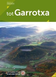
The Area of Natural Interest of Alta <strong>Garrotxa</strong><br />
stretches north of the Fluvià river and lies among La<br />
<strong>Garrotxa</strong>, El Ripollès and Alt Empordà, and on the<br />
border with northern Catalonia. It is primarily formed by<br />
limestone, with an abrupt landscape that gives its name<br />
to the area: “garrotxes” literally means “rough lands of<br />
bad tracks”. Its mountainous landscape is typical of the<br />
Pyrenees foothills, its highest peak being the Comanegra<br />
(1,557 m). A large part of the area is typically Mediterranean,<br />
covered by holm oak and downy oak forests,<br />
and some endemic species of plants that cannot be<br />
seen anywhere else in the world.<br />
Sant Sebastià de Monars<br />
The area’s limestone landscape offers spectacular cliffs<br />
and gorges eroded away by the rivers, with pools, caves<br />
and potholes (page 44).<br />
http://en.turismegarrotxa.com/la-garrotxa/<br />
territory-and-nature/<br />
To the west, the land becomes flatter and the climate<br />
more humid, making it more suitable for use by man<br />
(pages 46 and 48).<br />
Alta <strong>Garrotxa</strong> also has an extremely rich cultural heritage:<br />
country houses, hamlets, hermitages, charcoal kiln<br />
sites, etc., spread around the area and showing this<br />
area’s past importance of traditional, agricultural and<br />
livestock activities.<br />
The Transversal mountain chain draws out the<br />
western border of the district with the Santa Magdalena,<br />
Puigsacalm (1515 m), Llancers and Cabrera<br />
mountains, formed by layers of limestone, sandstone,<br />
marl and conglomerates that shape a flat landscape<br />
with plateaus and scarps, over which waterfalls run.<br />
The much more humid and mountainous climate is<br />
propense to hikes through beech and downy oak<br />
forests dotted with rambling meadows and excellent<br />
vantage points (pages 44 and 53)