CU Mar-Apr 2020

You also want an ePaper? Increase the reach of your titles
YUMPU automatically turns print PDFs into web optimized ePapers that Google loves.
SOFTWAREreview<br />
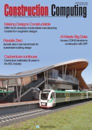
Importing a georeferenced shape file<br />
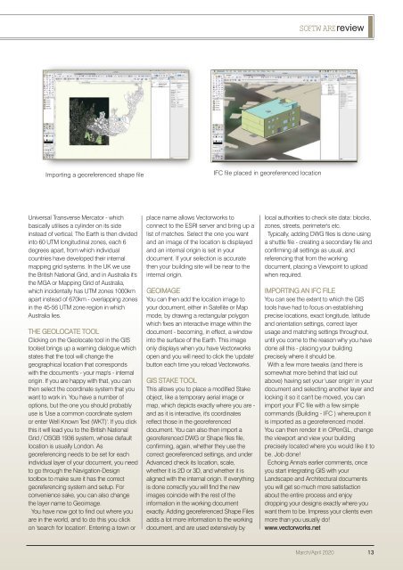
IFC file placed in georeferenced location<br />
Universal Transverse Mercator - which<br />
basically utilises a cylinder on its side<br />
instead of vertical. The Earth is then divided<br />
into 60 UTM longitudinal zones, each 6<br />
degrees apart, from which individual<br />
countries have developed their internal<br />
mapping grid systems. In the UK we use<br />
the British National Grid, and in Australia it's<br />
the MGA or Mapping Grid of Australia,<br />
which incidentally has UTM zones 1000km<br />
apart instead of 670km - overlapping zones<br />
in the 45-56 UTM zone region in which<br />
Australia lies.<br />
THE GEOLOCATE TOOL<br />
Clicking on the Geolocate tool in the GIS<br />
toolset brings up a warning dialogue which<br />
states that the tool will change the<br />
geographical location that corresponds<br />
with the document's - your map's - internal<br />
origin. If you are happy with that, you can<br />
then select the coordinate system that you<br />
want to work in. You have a number of<br />
options, but the one you should probably<br />
use is 'Use a common coordinate system<br />
or enter Well Known Text (WKT)'. If you click<br />
this it will lead you to the British National<br />
Grid / OSGB 1936 system, whose default<br />
location is usually London. As<br />
georeferencing needs to be set for each<br />
individual layer of your document, you need<br />
to go through the Navigation-Design<br />
toolbox to make sure it has the correct<br />
georeferencing system and setup. For<br />
convenience sake, you can also change<br />
the layer name to Geoimage.<br />
You have now got to find out where you<br />
are in the world, and to do this you click<br />
on 'search for location'. Entering a town or<br />
place name allows Vectorworks to<br />
connect to the ESRI server and bring up a<br />
list of matches. Select the one you want<br />
and an image of the location is displayed<br />
and an internal origin is set in your<br />
document. If your selection is accurate<br />
then your building site will be near to the<br />
internal origin.<br />
GEOIMAGE<br />
You can then add the location image to<br />
your document, either in Satellite or Map<br />
mode, by drawing a rectangular polygon<br />
which fixes an interactive image within the<br />
document - becoming, in effect, a window<br />
into the surface of the Earth. This image<br />
only displays when you have Vectorworks<br />
open and you will need to click the 'update'<br />
button each time you reload Vectorworks.<br />
GIS STAKE TOOL<br />
This allows you to place a modified Stake<br />
object, like a temporary aerial image or<br />
map, which depicts exactly where you are -<br />
and as it is interactive, it's coordinates<br />
reflect those in the georeferenced<br />
document. You can also then import a<br />
georeferenced DWG or Shape files file,<br />
confirming, again, whether they use the<br />
correct georeferenced settings, and under<br />
Advanced check its location, scale,<br />
whether it is 2D or 3D, and whether it is<br />
aligned with the internal origin. If everything<br />
is done correctly you will find the new<br />
images coincide with the rest of the<br />
information in the working document<br />
exactly. Adding georeferenced Shape Files<br />
adds a lot more information to the working<br />
document, and are used extensively by<br />
local authorities to check site data: blocks,<br />
zones, streets, perimeter's etc.<br />
Typically, adding DWG files is done using<br />
a shuttle file - creating a secondary file and<br />
confirming all settings as usual, and<br />
referencing that from the working<br />
document, placing a Viewpoint to upload<br />
when required.<br />
IMPORTING AN IFC FILE<br />
You can see the extent to which the GIS<br />
tools have had to focus on establishing<br />
precise locations, exact longitude, latitude<br />
and orientation settings, correct layer<br />
usage and matching settings throughout,<br />
until you come to the reason why you have<br />
done all this - placing your building<br />
precisely where it should be.<br />
With a few more tweaks (and there is<br />
somewhat more behind that laid out<br />
above) having set your 'user origin' in your<br />
document and selecting another layer and<br />
locking it so it can't be moved, you can<br />
import your IFC file with a few simple<br />
commands (Building - IFC ) whereupon it<br />
is imported as a georeferenced model.<br />
You can then render it in OPenGL, change<br />
the viewport and view your building<br />
precisely located where you would like it to<br />
be. Job done!<br />
Echoing Anna's earlier comments, once<br />
you start integrating GIS with your<br />
Landscape and Architectural documents<br />
you will get so much more satisfaction<br />
about the entire process and enjoy<br />
dropping your designs exactly where you<br />
want them to be. Impress your clients even<br />
more than you usually do!<br />
www.vectorworks.net<br />
<strong>Mar</strong>ch/<strong>Apr</strong>il <strong>2020</strong> 13