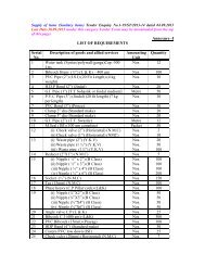
agronomy agricultural physics agricultural meteorology soil science
agronomy agricultural physics agricultural meteorology soil science
agronomy agricultural physics agricultural meteorology soil science

You also want an ePaper? Increase the reach of your titles
YUMPU automatically turns print PDFs into web optimized ePapers that Google loves.
7. Remote sensing of environment (2+1)<br />
Basic components of remote sensing; signals, sensors and sensing systems; active<br />
and passive remote sensing; characteristics of electromagnetic radiation's and its<br />
interaction with matter; spectral features of earth's surface features; remote sensors<br />
in visible, infrared and microwave regions; imaging and non-imaging systems, farming<br />
and scanning systems; resolution of sensors; sensor platforms, their launching<br />
and maintenance; data acquisition systems; data processing; data storage and dissemination;<br />
digital image processing and information interpretation; Introduction to<br />
Geographic Information System and Geographic Positioning Systems. Remote sensing<br />
techniques in environment; monitoring and study of land surface processes- atmospheric<br />
pollution monitoring, ground water pollution monitoring, flood and drought<br />
mapping, assessment of land degradation- <strong>soil</strong> erosion, reservoir sedimentation,<br />
desertification, salinization, de- and re- forestation, shifting cultivation, and forest<br />
fires; remote sensing for forest mapping, geological mapping, snow, glacier and ice<br />
cover inventory; remote sensing in weather forecasting, temperature and precipitation<br />
estimates.<br />
Practical<br />
Acquisition of maps; familiarization of remote sensing imagery; Use of spectro-radiometer;<br />
working out spectral indices over a crop under different management; crop<br />
stress detection; use of infrared thermometer for stress detection; image analysis<br />
using ARCINFO / EASYPACE / IDRISI; crop discrimination; supervised classification<br />
using ground truth; Geographic Information System (GIS ) application-<br />
ACRVIEW, SPANS; Use of Geographic Positioning System ( GPS) in agriculture.<br />
Suggested Readings<br />
Colwell, R.N. (Ed) Colwell Roberl N. Manual of Remote Sensing Vol. I& II, Am<br />
Soc. Photogrammetry, Virginia.<br />
Curan, P.J. Principles of Remote Sensing, ELBS/Longman.<br />
Jain, A.K, 1989 Fundamentals of Digital Image Processing, Prentice Hall of India,<br />
Saddle river, NJ.<br />
Kamat, D.S and Sinha, S.K Eds. Proceedings of the Seminar on Crop Growth Condition<br />
and Remote Sensing, June22-23, 1984, ICAR & ISRO.<br />
Lillesand, T.M and Kiffer, R.W. 1999. Remote Sensing and image interpretation, 4 th<br />
ed. John Wiley & son., Inc, New York.<br />
Majumdar, K..L et.al., 1983. Selection of spectral bands and their widths for the Indian<br />
Remote Sensing satellite (IRS). RSP-1P/TN03/83, Space Applications<br />
Centre, Ahmedabad-380 053.