Chapter 11--Rosgen Geomorphic Channel Design
Chapter 11--Rosgen Geomorphic Channel Design
Chapter 11--Rosgen Geomorphic Channel Design
Create successful ePaper yourself
Turn your PDF publications into a flip-book with our unique Google optimized e-Paper software.
<strong>Chapter</strong> <strong>11</strong><br />
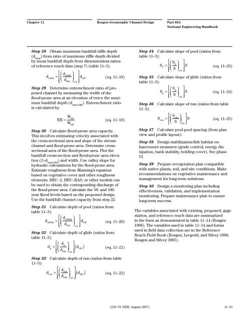
Step 28 Obtain maximum bankfull riffle depth<br />
(d max ) from ratio of maximum riffle depth divided<br />
by mean bankfull depth from dimensionless ratios<br />
of reference reach data (step 7) (table <strong>11</strong>–3).<br />
d<br />
mbkf<br />
d<br />
=<br />
d<br />
⎛ ⎡<br />
⎢<br />
⎝<br />
⎜<br />
⎣⎢<br />
mbkf<br />
⎞<br />
⎠<br />
⎟<br />
bkf ref<br />
⎤<br />
⎥ d<br />
⎦⎥<br />
bkf<br />
<strong>Rosgen</strong> <strong>Geomorphic</strong> <strong>Channel</strong> <strong>Design</strong><br />
(eq. <strong>11</strong>–18)<br />
Step 29 Determine entrenchment ratio of proposed<br />
channel by measuring the width of the<br />
flood-prone area at an elevation of twice the maximum<br />
bankfull depth (d max bkf ). Entrenchment ratio<br />
is calculated by:<br />
ER Wfpa<br />
= (eq. <strong>11</strong>–19)<br />
W<br />
bkf<br />
Step 30 Calculate flood-prone area capacity.<br />
This involves estimating velocity associated with<br />
the cross-sectional area and slope of the stream<br />
channel and flood-prone area. Determine crosssectional<br />
area of the flood-prone area. Plot the<br />
bankfull cross-section and flood-prone area elevation<br />
(2×d max bkf ) and width. Use valley slope for<br />
hydraulic calculations for the flood-prone area.<br />
Estimate roughness from Manning’s equation<br />
based on vegetative cover and other roughness<br />
elements. HEC–2, HEC–RAS, or other models can<br />
be used to obtain the corresponding discharge of<br />
the flood-prone area. Calculate the 50- and 100year<br />
flood levels based on the proposed design.<br />
Use the bankfull channel capacity from step 22.<br />
Step 31 Calculate depth of pool (ratios from<br />
table <strong>11</strong>–3):<br />
dmbkfp<br />
dmbkfp<br />
= dbkf<br />
dbkf<br />
ref<br />
⎛ ⎡ ⎞ ⎤<br />
⎢<br />
⎝<br />
⎜<br />
⎠<br />
⎟ ⎥<br />
(eq. <strong>11</strong>–20)<br />
⎣⎢<br />
⎦⎥<br />
Step 32 Calculate depth of glide (ratios from<br />
table <strong>11</strong>–3):<br />
dg<br />
dg<br />
= dbkf<br />
dbkf<br />
ref<br />
⎛ ⎡ ⎞ ⎤<br />
⎢<br />
⎝<br />
⎜<br />
⎠<br />
⎟ ⎥<br />
⎣⎢<br />
⎦⎥<br />
( ) (eq. <strong>11</strong>–21)<br />
Step 33 Calculate depth of run (ratios from table<br />
<strong>11</strong>–3):<br />
drun<br />
drun<br />
= dbkf<br />
dbkf<br />
ref<br />
⎛ ⎡ ⎞ ⎤<br />
⎢<br />
⎝<br />
⎜<br />
⎠<br />
⎟ ⎥<br />
⎣⎢<br />
⎦⎥<br />
( ) (eq. <strong>11</strong>–22)<br />
(210–VI–NEH, August 2007)<br />
Part 654<br />
National Engineering Handbook<br />
Step 34 Calculate slope of pool (ratios from<br />
table <strong>11</strong>–3):<br />
Sp<br />
Sp<br />
= S<br />
S ref<br />
⎛ ⎡ ⎞ ⎤<br />
⎢<br />
⎝<br />
⎜<br />
⎠<br />
⎟ ⎥<br />
(eq. <strong>11</strong>–23)<br />
⎣⎢<br />
⎦⎥<br />
Step 35 Calculate slope of glide (ratios from<br />
table <strong>11</strong>–3):<br />
S<br />
g<br />
Sg<br />
=<br />
S<br />
⎛ ⎡ ⎞<br />
⎢<br />
⎝<br />
⎜<br />
⎠<br />
⎟<br />
⎣⎢<br />
ref<br />
⎤<br />
⎥ S<br />
⎦⎥<br />
(eq. <strong>11</strong>–24)<br />
Step 36 Calculate slope of run (ratios from table<br />
<strong>11</strong>–3):<br />
S<br />
run<br />
Srun<br />
=<br />
S<br />
⎛ ⎡ ⎞<br />
⎢<br />
⎝<br />
⎜<br />
⎠<br />
⎟<br />
⎣<br />
ref<br />
⎤<br />
⎥ S<br />
(eq. <strong>11</strong>–25)<br />
⎦<br />
Step 37 Calculate pool-pool spacing (from plan<br />
view and profile layout).<br />
Step 38 <strong>Design</strong> stabilization/fish habitat enhancement<br />
measures (grade control, energy dissipation,<br />
bank stability, holding cover). See phase<br />
VI.<br />
Step 39 Prepare revegetation plan compatible<br />
with native plants, soil, and site conditions. Make<br />
recommendations on vegetative maintenance and<br />
management for long-term solutions.<br />
Step 40 <strong>Design</strong> a monitoring plan including<br />
effectiveness, validation, and implementation<br />
monitoring. Prepare maintenance plan to ensure<br />
long-term success.<br />
The variables associated with existing, proposed, gage<br />
station, and reference reach data are summarized<br />
in the form as demonstrated in table <strong>11</strong>–14 (<strong>Rosgen</strong><br />
1998). The variables used in table <strong>11</strong>–14 and forms<br />
used in field data collection are in the Reference<br />
Reach Field Book (<strong>Rosgen</strong>, Leopold, and Silvey 1998;<br />
<strong>Rosgen</strong> and Silvey 2005).<br />
<strong>11</strong>–53


