VGB PowerTech | Hydro - Hydropower Industry Guide 2020/21
Innovative products and services from operators, suppliers, manufacturers and consultants and a lot of sector information. 1st issue. Final version 2020/21 View online and download on demand!
Innovative products and services from operators, suppliers, manufacturers and consultants and a lot of sector information.
1st issue. Final version 2020/21
View online and download on demand!

Create successful ePaper yourself
Turn your PDF publications into a flip-book with our unique Google optimized e-Paper software.
HYDROPOWER INDUSTRY GUIDE <strong>2020</strong>/<strong>21</strong><br />
Company Profiles<br />
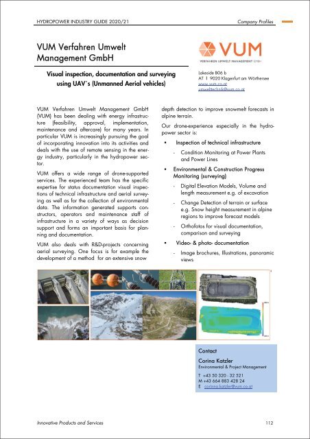
VUM Verfahren Umwelt<br />
Management GmbH<br />
Visual inspection, documentation and surveying<br />
using UAV`s (Unmanned Aerial vehicles)<br />
Lakeside B06 b<br />
AT Ι 9020 Klagenfurt am Wörthersee<br />
www.vum.co.at<br />
umwelttechnik@vum.co.at<br />
VUM Verfahren Umwelt Management GmbH<br />
(VUM) has been dealing with energy infrastructure<br />
(feasibility, approval, implementation,<br />
maintenance and aftercare) for many years. In<br />
particular VUM is increasingly pursuing the goal<br />
of incorporating innovation into its activities and<br />
deals with the use of remote sensing in the energy<br />
industry, particularly in the hydropower sector.<br />
VUM offers a wide range of drone-supported<br />
services. The experienced team has the specific<br />
expertise for status documentation visual inspections<br />
of technical infrastructure and aerial surveying<br />
as well as for the collection of environmental<br />
data. The information generated supports constructors,<br />
operators and maintenance staff of<br />
infrastructure in a variety of ways as decision<br />
support and forms an important basis for planning<br />
and documentation.<br />
VUM also deals with R&D-projects concerning<br />
aerial surveying. One focus is for example the<br />
development of a method for an extensive snow<br />
depth detection to improve snowmelt forecasts in<br />
alpine terrain.<br />
Our drone-experience especially in the hydropower<br />
sector is:<br />
• Inspection of technical infrastructure<br />
- Condition Monitoring at Power Plants<br />
and Power Lines<br />
• Environmental & Construction Progress<br />
Monitoring (surveying)<br />
- Digital Elevation Models, Volume and<br />
length measurement e.g. of excavation<br />
- Change Detection of terrain or surface<br />
e.g. Snow height measurement in alpine<br />
regions to improve forecast models<br />
- Orthofotos for visual documentation,<br />
comparison and surveying<br />
• Video- & photo- documentation<br />
- Image brochures, Illustrations, panoramic<br />
views<br />
Contact<br />
Corina Katzler<br />
Environmental & Project Management<br />
T +43 50 320 - 32 5<strong>21</strong><br />
M +43 664 883 428 24<br />
E corinna.katzler@vum.co.at<br />
Innovative Products and Services 112