Petroleum Systems of the Simeulue Fore-arc Basin - Search and ...
Petroleum Systems of the Simeulue Fore-arc Basin - Search and ...
Petroleum Systems of the Simeulue Fore-arc Basin - Search and ...

Create successful ePaper yourself
Turn your PDF publications into a flip-book with our unique Google optimized e-Paper software.
<strong>Petroleum</strong> <strong>Systems</strong> <strong>of</strong> <strong>the</strong> <strong>Simeulue</strong> <strong>Fore</strong>-<strong>arc</strong> <strong>Basin</strong> <strong>of</strong>f Sumatra, Indonesia*<br />
Ruediger Lutz 1 , Christoph Gaedicke 2 , Kai Berglar 2 , Dieter Franke 2 , Stefan Schloemer 2 <strong>and</strong> Yusuf S.<br />
Djajadihardja 3<br />
Se<strong>arc</strong>h <strong>and</strong> Discovery Article #10230 (2010)<br />
Posted February 24, 2010<br />
*Adapted from exp<strong>and</strong>ed abstract prepared for oral presentation at AAPG International Conference <strong>and</strong> Exhibition, Rio de<br />
Janeiro, Brazil, November 15-18, 2009<br />
1 BGR, Hannover, Germany (r.lutz@bgr.de)<br />
2 BGR, Hannover, Germany<br />
3 BPPT, Jakarta, Indonesia<br />
Abstract<br />
<strong>Fore</strong>-<strong>arc</strong> basins develop as a result <strong>of</strong> plate subduction <strong>and</strong> are situated <strong>of</strong>fshore, between an outer-<strong>arc</strong> high<br />
<strong>and</strong> <strong>the</strong> main l<strong>and</strong>. So far <strong>the</strong>se regions are not considered as important petroleum provinces because low<br />
heat flow does not necessarily support relevant petroleum generation. The <strong>Simeulue</strong> fore-<strong>arc</strong> basin extends<br />
between <strong>Simeulue</strong> Isl<strong>and</strong> <strong>and</strong> nor<strong>the</strong>rn Sumatra, Indonesia. Multichannel seismic data show bright spots<br />
above potential hydrocarbon reservoirs in carbonate platforms. AVO/AVA analyses indicate <strong>the</strong> presence <strong>of</strong><br />
gas in sediments. Surface geochemical prospecting suggests <strong>the</strong>rmal hydrocarbon generation within deep<br />
sediment strata. Heat flow in <strong>the</strong> <strong>Simeulue</strong> <strong>Basin</strong> ranges between 40 mW/m 2 <strong>and</strong> 60 mW/m 2 as deduced<br />
from 1-D petroleum systems modelling <strong>of</strong> well data <strong>and</strong> bottom-simulating reflector depths. Two source<br />
rocks (Eocene <strong>and</strong> Early-Middle Miocene) were assumed for 3-D petroleum system modelling in <strong>the</strong><br />
<strong>Simeulue</strong> <strong>Basin</strong>. Calculated heat flow scenarios (40 mW/m 2 <strong>and</strong> 60 mW/m 2 , respectively) reveal that<br />
hydrocarbon generation is possible in <strong>the</strong> main depocenters <strong>of</strong> <strong>the</strong> central <strong>and</strong> sou<strong>the</strong>rn <strong>Simeulue</strong> <strong>Basin</strong>. In<br />
<strong>the</strong> model with <strong>the</strong> higher heat flow <strong>the</strong> carbonate buildups were charged with oil <strong>and</strong> gas. This study shows<br />
that deep burial <strong>of</strong> source rocks can compensate for low heat flow <strong>and</strong> that fore-<strong>arc</strong> basins may be in general<br />
more prolific than previously thought. Consequently, fore-<strong>arc</strong> basins may become areas <strong>of</strong> future oil <strong>and</strong> gas<br />
exploration <strong>and</strong> production.<br />
Geologic Setting<br />
The western Indonesian fore-<strong>arc</strong> basins extend for more than 1800 km from northwest <strong>of</strong> Aceh to southwest<br />
<strong>of</strong> Java. The width <strong>of</strong> <strong>the</strong> basins varies from less than 70 km south <strong>of</strong> <strong>the</strong> Sunda Strait to about 120 km west<br />
<strong>of</strong>f nor<strong>the</strong>rn Sumatra. The basins form a strongly subsiding area between <strong>the</strong> elevated Paleozoic-Mesozoic<br />
Sumatra <strong>arc</strong> massif, cropping out along Sumatra <strong>and</strong> Java, <strong>and</strong> <strong>the</strong> rising outer-<strong>arc</strong> high (Karig et al., 1980;<br />
Schlueter et al., 2002; Susilohadi et al., 2005).<br />
The <strong>Simeulue</strong> fore-<strong>arc</strong> basin is bounded to <strong>the</strong> west by <strong>Simeulue</strong> Isl<strong>and</strong>. The Banyak Isl<strong>and</strong>s separate <strong>the</strong><br />
<strong>Simeulue</strong> <strong>Basin</strong> from <strong>the</strong> sou<strong>the</strong>rly located Nias fore-<strong>arc</strong> basin. The nor<strong>the</strong>rn end <strong>of</strong> <strong>the</strong> <strong>Simeulue</strong> <strong>Basin</strong> is<br />
formed by a morphological ridge corresponding to a change in water depth <strong>of</strong> more than 1500 m (Berglar et<br />
al., 2008; Izart et al., 1994). The studied area (Figure 1) is part <strong>of</strong> a classic example <strong>of</strong> a subduction system,<br />
composed <strong>of</strong> <strong>the</strong> downgoing Indo-Australian slab along <strong>the</strong> Sumatra trench, an accretionary wedge, <strong>the</strong><br />
outer-<strong>arc</strong> ridge emerging above sea level with <strong>Simeulue</strong> Isl<strong>and</strong> forming <strong>the</strong> most elevated part (Pubellier et<br />
al., 1992; Samuel <strong>and</strong> Harbury, 1996), <strong>and</strong> <strong>the</strong> <strong>Simeulue</strong> fore-<strong>arc</strong> basin in front <strong>of</strong> <strong>the</strong> volcanic <strong>arc</strong>.<br />
Convergence along <strong>the</strong> Sunda Arc becomes increasingly oblique from south to north resulting in large-scale,<br />
dextral strike-slip fault systems within <strong>the</strong> fore-<strong>arc</strong> basins <strong>and</strong> on Sumatra (Malod <strong>and</strong> Kemal, 1996; Sieh<br />
<strong>and</strong> Natawidjaja, 2000).<br />
The <strong>Simeulue</strong> <strong>Basin</strong> extends over 260 km in NW-SE direction <strong>and</strong> 100 km in SW-NE direction. It contains a<br />
Neogene sedimentary fill <strong>of</strong> up to 5 s two-way travel time (TWT), approximately 7 km. The water depth is<br />
at maximum 1300 m (Figure 2). Until <strong>the</strong> Early Miocene <strong>the</strong> geologic evolution <strong>of</strong> <strong>the</strong> <strong>Simeulue</strong> <strong>Basin</strong><br />
shows striking similarities to <strong>the</strong> evolution <strong>of</strong> <strong>the</strong> North Sumatra <strong>Basin</strong> (Figure 1; Barber et al., 2005).<br />
Copyright © AAPG. Serial rights given by author. For all o<strong>the</strong>r rights contact author directly.
North-south oriented horsts <strong>and</strong> grabens developed in <strong>the</strong> North Sumatra <strong>Basin</strong> during a Late Eocene rifting<br />
phase. A subsequent Late Oligocene-Early Miocene basin sag phase resulted in widespread carbonate<br />
deposition <strong>and</strong> reef growth (Clure, 2005). Initiation <strong>of</strong> Mid-Miocene wrench tectonics led to uplift <strong>of</strong> <strong>the</strong><br />
Barisan Range <strong>and</strong> separated <strong>the</strong> North Sumatra <strong>Basin</strong> from <strong>the</strong> modern fore-<strong>arc</strong> region, including <strong>the</strong><br />
<strong>Simeulue</strong> <strong>Basin</strong>. Ongoing compression since <strong>the</strong> Plio-Pleistocene formed <strong>the</strong> coastal fold belt <strong>of</strong> Sumatra<br />
(Clure, 2005).<br />
The present day back-<strong>arc</strong> area <strong>of</strong> Sumatra comprises <strong>the</strong> North Sumatra, Central Sumatra <strong>and</strong> South Sumatra<br />
<strong>Basin</strong>s, where prolific petroleum systems exist (e.g. Cole <strong>and</strong> Crittenden, 1997; Schiefelbein <strong>and</strong> Cameron,<br />
1997). Oil in <strong>the</strong> North Sumatra <strong>Basin</strong> was generated from both terrigenous <strong>and</strong> marine source rocks.<br />
Biomarkers indicative <strong>of</strong> both environments were found in oil samples (Schiefelbein <strong>and</strong> Cameron, 1997).<br />
The Central Sumatra <strong>Basin</strong> (Figure 1) is <strong>the</strong> most prolific petroleum system in Indonesia <strong>and</strong> is sourced by<br />
<strong>the</strong> Brown Shale Formation. (Clure, 2005; Peters et al., 2005). Source rocks <strong>of</strong> both basins are <strong>of</strong> Eocene-<br />
Oligocene age.<br />
Data<br />
During 2006 a total <strong>of</strong> 1500 km <strong>of</strong> multi-channel seismic (MCS) coincident with high resolution sediment<br />
echo-sounding, bathymetry, gravity <strong>and</strong> magnetic data were collected in <strong>the</strong> <strong>Simeulue</strong> <strong>Basin</strong> (Figure 2) using<br />
<strong>the</strong> German RV SONNE. MCS data were acquired with a 240 channel, 3 km streamer <strong>and</strong> a tuned airgun<br />
array comprising 16 airguns with a total capacity <strong>of</strong> 50.8 litres. Record length was 14 s with a sample<br />
interval <strong>of</strong> 2 milliseconds. A shot interval <strong>of</strong> 50 m resulted in a fold <strong>of</strong> 30 (6.25 m CMP distance).<br />
Additionally, sediment samples for hydrocarbon analysis were collected from cores taken with gravity (SL)<br />
<strong>and</strong> piston (KL) corers as well as samples from multicorers (MUC). Sampling sites were selected according<br />
to interpretation <strong>of</strong> <strong>the</strong> seismic data mainly above carbonate buildups <strong>and</strong> faults.<br />
Figure 3 illustrates <strong>the</strong> conceptual model <strong>of</strong> <strong>the</strong> <strong>Simeulue</strong> <strong>Basin</strong> with a deep basin center, where<br />
hydrocarbons are generated <strong>and</strong> subsequently migrate into adjacent carbonate buildups, forming <strong>the</strong><br />
reservoirs. Bright spots above potential hydrocarbon reservoirs indicate gas bearing sediments, sourced<br />
ei<strong>the</strong>r directly by <strong>the</strong>rmally generated hydrocarbon gas in <strong>the</strong> basin center or by leaking <strong>of</strong> hydrocarbon gas<br />
out <strong>of</strong> <strong>the</strong> carbonate buildups.
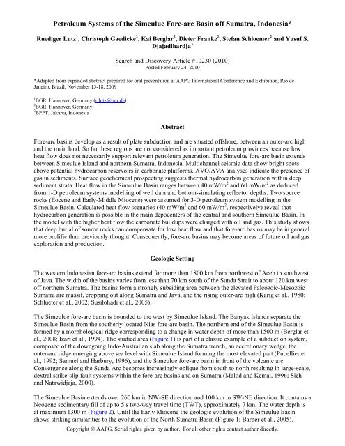
Figure 1. Regional tectonic setting <strong>of</strong> <strong>the</strong> Sunda subduction zone. The fore-<strong>arc</strong> basins <strong>of</strong>f Sumatra are located between<br />
Sumatra mainl<strong>and</strong> <strong>and</strong> <strong>the</strong> outer-<strong>arc</strong> high that occasionally emerges above sea level forming <strong>the</strong> isl<strong>and</strong> chain west <strong>of</strong><br />
Sumatra. Abbreviations: SFZ: Sumatran Fault Zone, MFZ: Mentawai Fault Zone, BF: Batee Fault, WAF: West<br />
Andaman Fault.
Figure 2. Location <strong>of</strong> multi-channel seismic pr<strong>of</strong>iles covering <strong>the</strong> <strong>Simeulue</strong> <strong>Basin</strong> between <strong>Simeulue</strong> Isl<strong>and</strong> <strong>and</strong> Sumatra.<br />
Isolines depict bathymetric contours (Smith <strong>and</strong> S<strong>and</strong>well, 1997) <strong>and</strong> circles show locations <strong>of</strong> wells (Beaudry <strong>and</strong> Moore,<br />
1985; Rose, 1983). Filled diamonds mark <strong>the</strong> locations <strong>of</strong> surface core gas samples. Hollow diamonds mark sections <strong>of</strong><br />
seismic lines used for AVO/AVA analysis.
Figure 3. Conceptual model depicted on seismic pr<strong>of</strong>ile BGR06-139. See Figure 2 for location <strong>of</strong> pr<strong>of</strong>ile.
Summary<br />
Interpretation <strong>of</strong> <strong>the</strong> seismic data, AVO/AVA modelling, surface geochemical analysis <strong>and</strong><br />
petroleum systems modelling reveal:<br />
� Bright spots occur widespread in <strong>the</strong> central <strong>Simeulue</strong> <strong>Basin</strong> in Late<br />
Miocene/Pliocene sediments <strong>and</strong> are most likely caused by gas-bearing sediments as<br />
supported by AVO/AVA analysis.<br />
� Heat flow in <strong>the</strong> basin ranges between 37 mW/m 2 <strong>and</strong> 74 mW/m 2 , according to 1-D<br />
modelling <strong>of</strong> six wells <strong>and</strong> BSR depths. Higher heat flows were measured at active<br />
fault zones.<br />
� Hydrocarbons potentially migrated from <strong>the</strong> depocenter into <strong>the</strong> proposed reservoir<br />
rocks.<br />
� Surface geochemical data suggest a <strong>the</strong>rmal origin <strong>of</strong> hydrocarbon gas from marine<br />
source rocks.<br />
� Carbonate buildups can serve as reservoirs <strong>and</strong> were charged with oil <strong>and</strong> gas in <strong>the</strong><br />
60 mW/m 2 model; additionally Late Miocene/Pliocene sediments might act as<br />
reservoirs.<br />
� The 40 mW/m 2 model predicts significantly less hydrocarbon generation. Here, <strong>the</strong><br />
amount <strong>of</strong> generated hydrocarbons is sufficient to explain <strong>the</strong> bright spots but <strong>the</strong><br />
carbonate reservoirs are not charged with significant amounts <strong>of</strong> hydrocarbons.<br />
References<br />
Barber, A.J., M.J. Crow, <strong>and</strong> M.E.M. de Smet, 2005, Tectonic evolution, in A. J. Barber, M. J. Crow <strong>and</strong> J. S.<br />
Milsom, eds., Sumatra: Geology, Resources <strong>and</strong> Tectonic Evolution: Memoir, v. 31, Geological Society,<br />
London, p. 234-259.<br />
Beaudry, D., <strong>and</strong> G.F. Moore, 1985, Seismic stratigraphy <strong>and</strong> Cenozoic evolution <strong>of</strong> West Sumatra fore-<strong>arc</strong><br />
basin: AAPG Bulletin, v. 69, p. 742-759.<br />
Berglar, K., C. Gaedicke, R. Lutz, D. Franke, <strong>and</strong> Y.S. Djajadihardja, 2008, Neogene subsidence <strong>and</strong><br />
stratigraphy <strong>of</strong> <strong>the</strong> <strong>Simeulue</strong> fore-<strong>arc</strong> basin, Northwest Sumatra: Marine Geology, v. 253, p. 1-13.<br />
Clure, J., 2005, Fuel resources: oil <strong>and</strong> gas, in A.J. Barber, M.J. Crow <strong>and</strong> J.S. Milsom, eds., Sumatra: Geology,<br />
Resources <strong>and</strong> Tectonic Evolution: Geological Society Memoir, v. 31, Geological Society, London, p. 131-<br />
141.<br />
Cole, J.M., <strong>and</strong> S. Crittenden, 1997, Early Tertiary basin formation <strong>and</strong> <strong>the</strong> development <strong>of</strong> lacustrine <strong>and</strong> quasilacustrine/marine<br />
source rocks on <strong>the</strong> Sunda Shelf <strong>of</strong> SE Asia, in A.J. Fraser, S.J. Mat<strong>the</strong>ws, <strong>and</strong> R.W.<br />
Murphy, eds., <strong>Petroleum</strong> geology <strong>of</strong> Sou<strong>the</strong>ast Asia, v. 126: United Kingdom, Geological Society <strong>of</strong><br />
London : London, United Kingdom, p. 147-183.<br />
Izart, A., B. Mustafa Kemal, <strong>and</strong> J.A. Malod, 1994, Seismic stratigraphy <strong>and</strong> subsidence evolution <strong>of</strong> <strong>the</strong><br />
Northwest Sumatra fore-<strong>arc</strong> basin: Marine Geology, v. 122, p. 109-124.<br />
Karig, D.E., M.B. Lawrence, G.F. Moore, <strong>and</strong> J.R. Curray, 1980, Structural framework <strong>of</strong> <strong>the</strong> fore-<strong>arc</strong> basin,<br />
NW Sumatra: Journal <strong>of</strong> <strong>the</strong> Geological Society <strong>of</strong> London, v. 137, Part 1, p. 77-91.<br />
Malod, J.A., <strong>and</strong> B.M. Kemal, 1996, The Sumatra Margin; oblique subduction <strong>and</strong> lateral displacement <strong>of</strong> <strong>the</strong><br />
accretionary prism: Geological Society Special Publications, v. 106, p. 19-28.<br />
Peters, K.E., J.M. Moldowan, <strong>and</strong> C.C. Walters, 2005, The biomarker guide; II, Biomarkers <strong>and</strong> isotopes in<br />
petroleum systems <strong>and</strong> Earth history: Cambridge University Press, p. 475-1155.
Pubellier, M., C. Rangin, J.P. Cadet, I. Tjashuri, J. Butterlin, <strong>and</strong> C.M. Mueller, 1992, L'iIle de Nias, un edifice<br />
polyphase sur la bordure interne de la fosse de la Sonde (<strong>arc</strong>hipel de Mentawai, Indonesie): Comptes<br />
Rendus de lAcademie des Sciences, Serie 2, Mecanique, Physique, Chimie, Sciences de lUnivers, Sciences<br />
de la Terre, v. 315, p. 1019-1026.<br />
Rose, R.R., 1983, Miocene carbonate rocks <strong>of</strong> Sibolga <strong>Basin</strong>, Northwest Sumatra: Proceedings Indonesian<br />
<strong>Petroleum</strong> Association, v. Twelfth Annual Convention, June, 1983, p. 107-125.<br />
Samuel, M.A., <strong>and</strong> N.A. Harbury, 1996, The Mentawai fault zone <strong>and</strong> deformation <strong>of</strong> <strong>the</strong> Sumatran <strong>Fore</strong>-<strong>arc</strong> in<br />
<strong>the</strong> Nias area: Geological Society Special Publications, v. 106, p. 337-351.<br />
Schiefelbein, C., <strong>and</strong> N. Cameron, 1997, Sumatra/Java oil families, in A.J. Fraser, S.J. Mat<strong>the</strong>ws, <strong>and</strong> R.W.<br />
Murphy, eds., Geological Society Special Publications, v. 126: London, Geological Society <strong>of</strong> London, p.<br />
143-146.<br />
Schlueter, H.U., C. Gaedicke, H.A. Roeser, B. Schreckenberger, H. Meyer, C. Reichert, Y. Djajadihardja, <strong>and</strong><br />
A. Prexl, 2002, Tectonic features <strong>of</strong> <strong>the</strong> sou<strong>the</strong>rn Sumatra-western Java fore-<strong>arc</strong> <strong>of</strong> Indonesia: Tectonics, v.<br />
21, p. 1047.<br />
Sieh, K., <strong>and</strong> D. Natawidjaja, 2000, Neotectonics <strong>of</strong> <strong>the</strong> Sumatran Fault, Indonesia: Journal <strong>of</strong> Geophysical<br />
Rese<strong>arc</strong>h, v. 105, p. 28,295-28,326.<br />
Smith, W.H.F., <strong>and</strong> D.T. S<strong>and</strong>well, 1997, Global sea floor topography from satellite altimetry <strong>and</strong> ship depth<br />
soundings: Science, v. 277, p. 1956-1962.<br />
Susilohadi, S., C. Gaedicke, <strong>and</strong> A. Erhard, 2005, Neogene structures <strong>and</strong> sedimentation history along <strong>the</strong> Sunda<br />
fore-<strong>arc</strong> basins <strong>of</strong>f southwest Sumatra <strong>and</strong> southwest Java: Marine Geology, v. 219, p. 133-154.