
You also want an ePaper? Increase the reach of your titles
YUMPU automatically turns print PDFs into web optimized ePapers that Google loves.
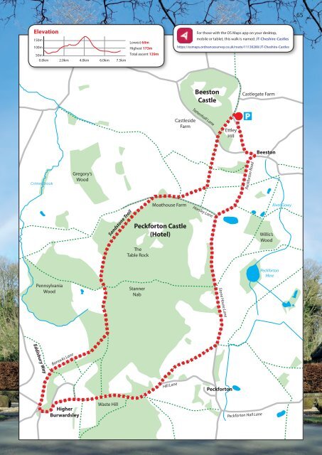
65<br />
Elevation<br />
150m<br />
100m<br />
50m<br />
0.0km 2.0km 4.0km 6.0km 7.5km<br />
Lowest 64m<br />
Highest 173m<br />
Total ascent 139m<br />
For those with the OS Maps app on your desktop,<br />
mobile or tablet, this walk is named: JT-Cheshire-Castles<br />
https://osmaps.ordnancesurvey.co.uk/route/11130280/JT-Cheshire-Castles<br />
Castleside<br />
Farm<br />
Beeston<br />
Castle<br />
Tattenhall Lane<br />
Ettley<br />
Hill<br />
Castlegate Farm<br />
P<br />
Beeston<br />
Crimes Brook<br />
Gregory’s<br />
Wood<br />
Peckforton Road<br />
Sandstone Trail<br />
Moathouse Farm<br />
Peckforton Castle<br />
(Hotel)<br />
The<br />
Table Rock<br />
Horsley Lane<br />
Willis’s<br />
Wood<br />
River Gowy<br />
Peckforton<br />
Mere<br />
Pennsylvania<br />
Wood<br />
<strong>St</strong>anner<br />
Nab<br />
<strong>St</strong>one House Lane<br />
Eddisbury Way<br />
Barracks Lane<br />
Hill Lane<br />
Peckforton<br />
Higher<br />
Burwardsley<br />
Waste Hill<br />
Peckforton Hall Lane