
You also want an ePaper? Increase the reach of your titles
YUMPU automatically turns print PDFs into web optimized ePapers that Google loves.
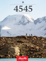
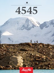
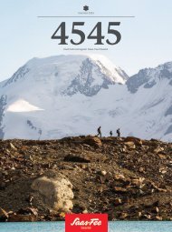
A MOATED CASTLE AND TRUE POWERHOUSE<br />
The Mattmark Dam has a turbulent history.<br />
It not only serves guests and locals as a place<br />
of power – but also supplies thousands<br />
households with electricity.<br />
Text: Patrick Gasser<br />
Images: levin.studio / Alberto @swiss<br />
1965 – disaster strikes<br />
Studies in the 1950s showed that the enormous power of<br />
the water mass in the Mattmark area could also be beneficial.<br />
Kraftwerke Mattmark AG began construction of the present<br />
dam in 1958. Today, the dammed water uses its power<br />
to drive turbines for electricity production and supplies thousands<br />
of households with electricity. Before the dam was<br />
completed seven years after construction began, the ‘dragon’<br />
struck again: on 30 August 1965, part of the glacier tongue<br />
of the Allalin glacier broke off. Two million cubic metres of<br />
ice and debris thundered down onto the workers’ shelters at<br />
the construction site on the dam. 88 workers, the majority of<br />
them Italian guest workers, died. Recovering the dead took<br />
months. Today, a memorial not far from the site of the accident<br />
commemorates the victims. The Mattmark Half-Marathon,<br />
launched five years ago, is also held in memory of the<br />
deceased.<br />
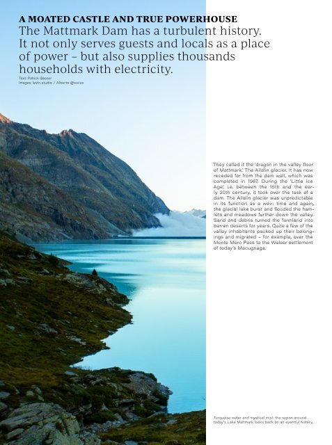
They called it the ‘dragon in the valley floor<br />
of Mattmark’. The Allalin glacier. It has now<br />
receded far from the dam wall, which was<br />
completed in 1967. During the ‘Little Ice<br />
Age’, i.e. between the 15th and the early<br />
20th century, it took over the task of a<br />
dam. The Allalin glacier was unpredictable<br />
in its function as a weir: time and again,<br />
the glacial lake burst and flooded the hamlets<br />
and meadows further down the valley.<br />
Sand and debris turned the farmland into<br />
barren deserts for years. Quite a few of the<br />
valley inhabitants packed up their belongings<br />
and migrated – for example, over the<br />
Monte Moro Pass to the Walser settlement<br />
of today’s Macugnaga.<br />
A true powerhouse<br />
Today, the lake fills and empties as the power plant operators<br />
intend. In spring, the meltwater is fed into the lake through a<br />
system of pipelines. As the snow melts, the lake level rises.<br />
The constant change of the seasons is felt particularly strongly<br />
here. In winter, hikers pass the top of the dam on their descent<br />
from the Fluchthorn. It gets busier in the <strong>summer</strong>. Then<br />
the restaurant is also open. The bus service takes families to<br />
the starting point of the approximately eight-kilometre hike<br />
around the lake. Everywhere the water tumbles via falls and<br />
streams and onto the lake surface. The power of nature is thus<br />
particularly palpable. And it seems to pass over to you when<br />
you feel the cold spray of the waterfalls on your skin.<br />
Only a few steps away from the dam, the last signal<br />
bar on your smartphone disappears. Sparse network coverage<br />
helps visitors to slow down. However, it is also important<br />
to bear this in mind when hiking into the deserted ‘Ofental’<br />
valley or towards the Monte Moro Pass. The smartphone only<br />
picks up the next mobile network later from the Italian side of<br />
the border. Here in the moated castle of the Upper Valais, the<br />
weather can suddenly change even in <strong>summer</strong>: not only does<br />
the network coverage here increasingly come from Italy, but<br />
also thunderstorms.<br />
Along the lakefront, you will find another elemental<br />
force in the form of the Eringer cows. These animals of ancient<br />
decent have been grazing in the region here for centuries.<br />
With the retreat of the Allalin glacier, their <strong>summer</strong> pasture<br />
gradually increases in size.<br />
8<br />
Discover the adventure worlds on p. 10<br />
More about the Mattmark area<br />
saas-fee.ch/mattmark<br />
Hiking tip<br />
The approximately eight-kilometre circuit around<br />
Lake Mattmark is also ideal for families. If you<br />
take a good two hours, you can let the power of<br />
nature unleash its wonderful effect on you. The<br />
trail is relatively even and, with only a good 100<br />
metres of ascent and descent, slightly elevated<br />
along the lakefront. At the same time, the Mattmark<br />
Dam, which is accessible by bus, is also<br />
the starting point for more challenging hikes in<br />
the direction of the Monte Moro Pass, Ofental<br />
or Jazzilücke. However, these hikes should be<br />
planned well and started early. In <strong>summer</strong>, spring<br />
clouds often form in the region around the Monte<br />
Moro Pass, which can envelop the area in fog.<br />
Turquoise water and mystical mist: the region around<br />
today’s Lake Mattmark looks back on an eventful history.<br />
28 29