proposition 1

Create successful ePaper yourself
Turn your PDF publications into a flip-book with our unique Google optimized e-Paper software.
PROPOSITION 1
Knowledge about cartopology is gained
by working as a cartopologist in an
integral self-sufficient artistic research
practice.
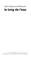
routes:
local loop
point to point
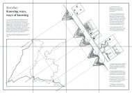
A PANORAMIC VIEW
This panoramic view of a mountain doesn’t
just come from anywhere. It fits the context and
visualization of cartopology in a broad field of
research disciplines, but to be honest, I also just really
like mountains. It don’t even have to be very high
ones. I enjoy them for running, hiking or just being
outside. Sharing this panorama, I share a piece of
my personal life. Doing so, I take part in my research.
Caropological researchers position themselves within
their research. I am both present on the mountain,
navigating through my research project and making
and moulding it at the same time. I know through the
exploration of a yet to be discovered mountain side.
Mountains are often equipped with cable
elevators. To get to a higher part, faster and with less
energy and effort, or sometimes to get all the way
to the top. The Aiguille du Midi in the Mont-Blanc-
Massif in the French Alps has been the largest cable
elevator for two decades and brings you without any
effort but 67 euros for one adult to the 3842m high
terrace. (1) Even some hills in the Netherlands like
the Heunsberg, with its summit at 145m above sea
level in Valkenburg aan de Geul are equipped with
a cable elevator. (2) Mountains stimulate a kind of
urge to reach the highest peak. I don’t feel that urge
myself, or to be honest, I’ve learned myself not aiming
for the summit. Trail runners and hikers don’t want
to take the elevator to the summit, they rather take
on the challenge of climbing the mountain. Being an
amateur trailrunner myself, the end of my runs is not
at the summit but rather back down, maybe on the
other side of the massif. We undertake expeditions on
the mountain sides focusing on being on exploration
without a fixed goal. In this perspective the summit
becomes a decadent isolated place, reached by
using elevators, detached from its context. The
changing fauna and flora, experiencing the tree line
and so many other things you encounter along the
way, how can you ‘skip’ that by taking a cable car to
fulfill your urge to the summit? (3)
A simple way to draw a mountain’s side -and
topview are a triangle, looking at it from the side, or
a circle, then looking at it from above. The dot in the
center of the circle then represents the top of the
mountain. That peak is isolated, sometimes above
the clouds with only other peaks in the distance
accompanying it. Going there, to the summit or the
dot, it is inevitable to cross the circle. The mountainside
of this panoramic view represents being on the
move, the processual, the making rather than the
result, without a predetermined direction.
At the foot of the mountain, in the valley, the flanks
of other mountains in the massif touch one another.
Mountains are created by movement of tectonic
plates. Two modes of movement underlie them. (4)
Plates collide and, in the process, press and fold the
earth’s crust. Or, plates drift apart causing the earth’s
interior, magma, to flow upward and create a volcano
or mountain. This movement and friction never ends.
As a result, the continents move a few centimeters
each year. The foot of the mountain of this panoramic
view in front of you localizes and represents
disciplines, research attitudes and worlds to which
cartopology must constantly relate. It differs from
the summit where, in clear weather, distances seem
insurmountable, or clouds obstruct all vision feeding
a feeling of isolation and monopoly. Excluding the top
from this panoramic view, Cartopology moves and
bends, like the tectonic plates, with its environment
and sometimes that involves friction, sometimes it
moves smoothly.
Exploring this mountain-side, loosing my
way, making new paths and setting up expeditions is
where I most enjoy to be. Without losing sight of the
valley I shape cartopology. And, also, where, to be
honest, I prefer to run.
And I am not running alone but on the
mountain-side, and unlike the top where only a
selection of people comes, I meet a motley crew of
policy makers, designers, map enthusiasts, scientists,
residents and artists. They come through different
paths and from different valleys such as art and
science, amateur and professional and from different
disciplines. Refuges like Le Brévent (2525m), Plan
Praz (2000m), Téte aux Vents (2123m,) Plan de
l’Aguille (2207m) and the oldest one in history (since
1793) Montenvers (1913m) are only part of a short
list of the over 30 refuges in the Mont-Blanc-Massif
I visited during the summer of 2021. They provide
shelter from the harsh environment in the mountains
that are generally accessible only by foot. Some
only provide food, safety and a matrass to sleep on.
While other provide another range of services like
lectures and workshops. The Institute of Cartopology
takes the same role as the refuges on the mountainsides
of the Mont-Blanc-Massif. Offering shelter for
and welcoming all kinds of mapmakers, engaging
in experiments in the field, lecturing and sharing
insights about the craft of cartopological mapping.
Sharing brave stories from the harsh environment
and generating a cartopological network in a noncompetitive
setting taking in account and situated
in the mountain-side - that is the method that the
Institute of Cartopology is making its own. The
Institute of Cartopology is not facilitating discussion
about cartopology but forces us to think by means of
it.
1 The Aiguille du Midi came into my life hiking and trail
running in the Mont Blanc Massif during the summer of 2021
departing from Chamonix. The refuge Plan d’Aiguille made me
aware of these types of entertainment in the mountains. With
my partner Remy Kroese we tend to make use of these cable
elevators as part of our run rather than a back and forward to
the summit. For example from Le Brévent to Lac Cornu.
2 I came across that cable elevator during a project I conducted
with Dear Hunter for the municipality of Valkenburg aan de
Geul in the summer of 2020.
3 I learned about the tree line through the lovely map
Geographie der Pflanzen in den Tropen-Ländern he made in
1807. During on of our trailruns in the summer of 2021 in the
Mont Blanc Massif, the path became smaller, and the precipice
steeper. At around 2000 meter elevation, a bit misty and humid,
all of the sudden we were surrounded by the greenest swamp I
had ever seen instead of trees.
4 As a teenager in geography classes I learned about the
formation of the continents and the shape of the surface of the
earth, including the movement of tectonic plates.