

Historical and Projected Coastal Louisiana Land Changes
Historical and Projected Coastal Louisiana Land Changes
Historical and Projected Coastal Louisiana Land Changes

You also want an ePaper? Increase the reach of your titles
YUMPU automatically turns print PDFs into web optimized ePapers that Google loves.
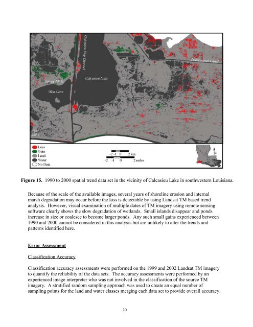
Figure 15. 1990 to 2000 spatial trend data set in the vicinity of Calcasieu Lake in southwestern <strong>Louisiana</strong>.<br />
Because of the scale of the available images, several years of shoreline erosion <strong>and</strong> internal<br />
marsh degradation may occur before the loss is detectable by using L<strong>and</strong>sat TM based trend<br />
analysis. However, visual examination of multiple dates of TM imagery using remote sensing<br />
software clearly shows the slow degradation of wetl<strong>and</strong>s. Small isl<strong>and</strong>s disappear <strong>and</strong> ponds<br />
increase in size or coalesce to become larger ponds. Any such small gains experienced between<br />
1990 <strong>and</strong> 2000 cannot be considered in this analysis but are unlikely to alter the trends <strong>and</strong><br />
patterns identified here.<br />
Error Assessment<br />
Classification Accuracy<br />
Classification accuracy assessments were performed on the 1999 <strong>and</strong> 2002 L<strong>and</strong>sat TM imagery<br />
to quantify the reliability of the data sets. The accuracy assessments were performed by an<br />
experienced image interpreter who was not involved in the classification of the source TM<br />
imagery. A stratified r<strong>and</strong>om sampling approach was used to create an equal number of<br />
sampling points for the l<strong>and</strong> <strong>and</strong> water classes merging each data set to provide overall accuracy.<br />
20


