Historical and Projected Coastal Louisiana Land Changes
Historical and Projected Coastal Louisiana Land Changes
Historical and Projected Coastal Louisiana Land Changes
Create successful ePaper yourself
Turn your PDF publications into a flip-book with our unique Google optimized e-Paper software.
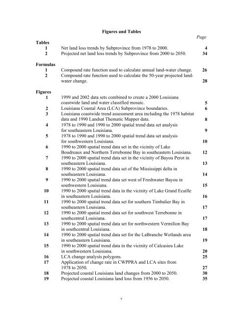
Figures <strong>and</strong> Tables<br />
Page<br />
Tables<br />
1 Net l<strong>and</strong> loss trends by Subprovince from 1978 to 2000. 4<br />
2 <strong>Projected</strong> net l<strong>and</strong> loss trends by Subprovince from 2000 to 2050. 34<br />
Formulas<br />
1 Compound rate function used to calculate annual l<strong>and</strong>-water change. 26<br />
2 Compound rate function used to calculate the 50-year projected l<strong>and</strong>water<br />
change.<br />
28<br />
Figures<br />
1 1999 <strong>and</strong> 2002 data sets combined to create a 2000 <strong>Louisiana</strong><br />
coastwide l<strong>and</strong> <strong>and</strong> water classified mosaic. 5<br />
2 <strong>Louisiana</strong> <strong>Coastal</strong> Area (LCA) Subprovince boundaries. 6<br />
3 <strong>Louisiana</strong> coastwide trend assessment area including the 1978 habitat<br />
data <strong>and</strong> 1990 L<strong>and</strong>sat Thematic Mapper data. 8<br />
4 1978 to 1990 <strong>and</strong> 1990 to 2000 spatial trend data set analysis<br />
for southeastern <strong>Louisiana</strong>. 9<br />
5 1978 to 1990 <strong>and</strong> 1990 to 2000 spatial trend data set analysis<br />
for southwestern <strong>Louisiana</strong>. 10<br />
6 1990 to 2000 spatial trend data set in the vicinity of Lake<br />
Boudreaux <strong>and</strong> Northern Terrebonne Bay in southeastern <strong>Louisiana</strong>. 12<br />
7 1990 to 2000 spatial trend data set in the vicinity of Bayou Perot in<br />
southeastern <strong>Louisiana</strong>. 13<br />
8 1990 to 2000 spatial trend data set of the Mississippi delta in<br />
southeastern <strong>Louisiana</strong>. 14<br />
9 1990 to 2000 spatial trend data set west of Freshwater Bayou in<br />
southwestern <strong>Louisiana</strong>. 15<br />
10 1990 to 2000 spatial trend data in the vicinity of Lake Gr<strong>and</strong> Ecaille<br />
in southeastern <strong>Louisiana</strong>. 16<br />
11 1990 to 2000 spatial trend data set for southern Timbalier Bay in<br />
southeastern <strong>Louisiana</strong>. 17<br />
12 1990 to 2000 spatial trend data set for southwest Terrebonne in<br />
southcentral <strong>Louisiana</strong>. 17<br />
13 1990 to 2000 spatial trend data set for northwestern Vermilion Bay<br />
in southcentral <strong>Louisiana</strong>. 18<br />
14 1990 to 2000 spatial trend data set for the LaBranche Wetl<strong>and</strong>s area<br />
in southeastern <strong>Louisiana</strong>. 19<br />
15 1990 to 2000 spatial trend data in the vicinity of Calcasieu Lake<br />
in southwestern <strong>Louisiana</strong>. 20<br />
16 LCA change analysis polygons. 25<br />
17 Application of change rate in CWPPRA <strong>and</strong> LCA sites from<br />
1978 to 2050. 27<br />
18 <strong>Projected</strong> coastal <strong>Louisiana</strong> l<strong>and</strong> changes from 2000 to 2050. 30<br />
19 <strong>Projected</strong> coastal <strong>Louisiana</strong> l<strong>and</strong> loss from 1956 to 2050. 35<br />
v


