STORM TIDE EVACUATION GUIDE - Townsville City Council
STORM TIDE EVACUATION GUIDE - Townsville City Council
STORM TIDE EVACUATION GUIDE - Townsville City Council

You also want an ePaper? Increase the reach of your titles
YUMPU automatically turns print PDFs into web optimized ePapers that Google loves.
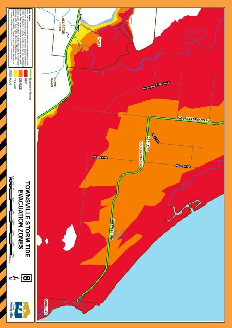
BLUE<br />
Meters<br />
DISCLAIMER<br />
Storm Tide Evacuation Zones are based upon geographical data.<br />
Evacuation Zones are designed to provide an easy to understand<br />
method for the public to identify coastal areas that may be affected<br />
by storm tides caused by tropical cyclones or severe east coast<br />
storms. Every effort has been made to ensure that the information<br />
contained within these Public Information Maps is accurate.<br />
However, <strong>Townsville</strong> <strong>City</strong> <strong>Council</strong> does not give any warranty or<br />
accept any liability in relation to the content of these maps.<br />
YELLOW<br />
500 250 0 500 1,000 1,500 2,000 2,500 3,000<br />
ORANGE<br />
Evacuation Routes<br />
RED<br />
TOWNSVILLE <strong>STORM</strong> <strong>TIDE</strong><br />
<strong>EVACUATION</strong> ZONES<br />
8<br />
CUNGULLA<br />
MOUNT<br />
ELLIOT<br />
ALLIGATOR<br />
CREEK<br />
BRUCE HWY<br />
NOME<br />
18<br />
CROCODILE CREEK RD<br />
CAPE CLEVELAND<br />
RILEY R D<br />
MEEHAN RD MEEHAN RD<br />
GOODSELL RD<br />
CARTY RD<br />
CAPE CLEVELAND RD