Download the Management Plan - Carlisle City Council
Download the Management Plan - Carlisle City Council
Download the Management Plan - Carlisle City Council

You also want an ePaper? Increase the reach of your titles
YUMPU automatically turns print PDFs into web optimized ePapers that Google loves.
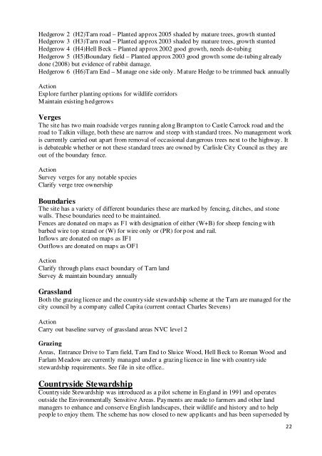
Hedgerow 2 (H2)Tarn road – <strong>Plan</strong>ted approx 2005 shaded by mature trees, growth stunted<br />
Hedgerow 3 (H3)Tarn road – <strong>Plan</strong>ted approx 2003 shaded by mature trees, growth stunted<br />
Hedgerow 4 (H4)Hell Beck – <strong>Plan</strong>ted approx 2002 good growth, needs de-tubing<br />
Hedgerow 5 (H5)Boundary field – <strong>Plan</strong>ted approx 2003 good growth some de-tubing already<br />
done (2008) but evidence of rabbit damage.<br />
Hedgerow 6 (H6)Tarn End – Manage one side only. Mature Hedge to be trimmed back annually<br />
Action<br />
Explore fur<strong>the</strong>r planting options for wildlife corridors<br />
Maintain existing hedgerows<br />
Verges<br />
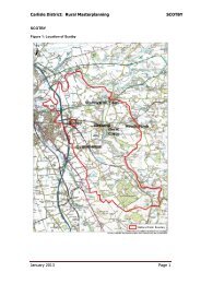
The site has two main roadside verges running along Brampton to Castle Carrock road and <strong>the</strong><br />
road to Talkin village, both <strong>the</strong>se are narrow and steep with standard trees. No management work<br />
is currently carried out apart from removal of occasional dangerous trees next to <strong>the</strong> highway. It<br />
is debateable whe<strong>the</strong>r or not <strong>the</strong>se standard trees are owned by <strong>Carlisle</strong> <strong>City</strong> <strong>Council</strong> as <strong>the</strong>y are<br />
out of <strong>the</strong> boundary fence.<br />
Action<br />
Survey verges for any notable species<br />
Clarify verge tree ownership<br />
Boundaries<br />
The site has a variety of different boundaries <strong>the</strong>se are marked by fencing, ditches, and stone<br />
walls. These boundaries need to be maintained.<br />
Fences are donated on maps as F1 with designation of ei<strong>the</strong>r (W+B) for sheep fencing with<br />
barbed wire top strand or (W) for wire only or (PR) for post and rail.<br />
Inflows are donated on maps as IF1<br />
Outflows are donated on maps as OF1<br />
Action<br />
Clarify through plans exact boundary of Tarn land<br />
Survey & maintain boundary annually<br />
Grassland<br />
Both <strong>the</strong> grazing licence and <strong>the</strong> countryside stewardship scheme at <strong>the</strong> Tarn are managed for <strong>the</strong><br />
city council by a company called Capita (current contact Charles Stevens)<br />
Action<br />
Carry out baseline survey of grassland areas NVC level 2<br />
Grazing<br />
Areas, Entrance Drive to Tarn field, Tarn End to Sluice Wood, Hell Beck to Roman Wood and<br />
Farlam Meadow are currently managed under a grazing licence in line with countryside<br />
stewardship requirements. See file in site office..<br />
Countryside Stewardship<br />
Countryside Stewardship was introduced as a pilot scheme in England in 1991 and operates<br />
outside <strong>the</strong> Environmentally Sensitive Areas. Payments are made to farmers and o<strong>the</strong>r land<br />
managers to enhance and conserve English landscapes, <strong>the</strong>ir wildlife and history and to help<br />
people to enjoy <strong>the</strong>m. The scheme has now closed to new applicants and has been superseded by<br />
22