

Strategic Projects along the Waterfront - City of Greater Geelong
Strategic Projects along the Waterfront - City of Greater Geelong
Strategic Projects along the Waterfront - City of Greater Geelong

Create successful ePaper yourself
Turn your PDF publications into a flip-book with our unique Google optimized e-Paper software.
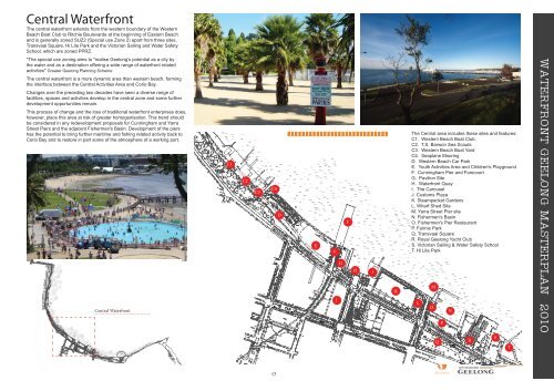
Central <strong>Waterfront</strong><br />
The central waterfront extends from <strong>the</strong> western boundary <strong>of</strong> <strong>the</strong> Western<br />
Beach Boat Club to Ritchie Boulevarde at <strong>the</strong> beginning <strong>of</strong> Eastern Beach<br />
and is generally zoned SUZ2 (Special use Zone 2) apart from three sites,<br />
Transvaal Square, Hi Lite Park and <strong>the</strong> Victorian Sailing and Water Safety<br />
School, which are zoned PPRZ.<br />
*The special use zoning aims to "realise <strong>Geelong</strong>'s potential as a city by<br />
<strong>the</strong> water and as a destination <strong>of</strong>fering a wide range <strong>of</strong> waterfront related<br />
activities" <strong>Greater</strong> <strong>Geelong</strong> Planning Scheme<br />
The central waterfront is a more dynamic area than western beach, forming<br />
<strong>the</strong> interface between <strong>the</strong> Central Activities Area and Corio Bay.<br />
Changes over <strong>the</strong> preceding two decades have seen a diverse range <strong>of</strong><br />
facilities, spaces and activities develop in <strong>the</strong> central zone and some fur<strong>the</strong>r<br />
development opportunities remain.<br />
This process <strong>of</strong> change and <strong>the</strong> loss <strong>of</strong> traditional waterfront enterprises does,<br />
however, place this area at risk <strong>of</strong> greater homogenisation. This trend should<br />
be considered in any redevelopment proposals for Cunningham and Yarra<br />
Street Piers and <strong>the</strong> adjacent Fishermen's Basin. Development <strong>of</strong> <strong>the</strong> piers<br />
has <strong>the</strong> potential to bring fur<strong>the</strong>r maritime and fi shing related activity back to<br />
Corio Bay and to restore in part some <strong>of</strong> <strong>the</strong> atmosphere <strong>of</strong> a working port.<br />
Central <strong>Waterfront</strong><br />
C1<br />
C2<br />
C3<br />
C4<br />
17<br />
D<br />
E<br />
F<br />
J<br />
G<br />
F<br />
H I<br />
K<br />
The Central area includes <strong>the</strong>se sites and features:<br />
C1. Western Beach Boat Club,<br />
C2. T.S. Barwon Sea Scouts<br />
C3. Western Beach Boat Yard<br />
C4. Seaplane Mooring<br />
D. Western Beach Car Park<br />
E. Youth Activities Area and Children's Playground<br />
F. Cunningham Pier and Forecourt<br />
G. Pavilion Site<br />
H. <strong>Waterfront</strong> Quay<br />
I. The Carousel<br />
J. Customs Plaza<br />
K. Steampacket Gardens<br />
L. Wharf Shed Site<br />
M. Yarra Street Pier site<br />
N. Fishermen's Basin<br />
O. Fishermen's Pier Restaurant<br />
P. Fairnie Park<br />
Q. Transvaal Square<br />
R. Royal <strong>Geelong</strong> Yacht Club<br />
S. Victorian Sailing & Water Safety School<br />
T. Hi Lite Park<br />
L<br />
M<br />
O<br />
Q<br />
P<br />
N<br />
Urban Initiatives<br />
R<br />
S<br />
T<br />
WATERFRONT GEELONG MASTERPLAN 2010


