The Air Navigation System Plan - Nav Canada
The Air Navigation System Plan - Nav Canada
The Air Navigation System Plan - Nav Canada

Create successful ePaper yourself
Turn your PDF publications into a flip-book with our unique Google optimized e-Paper software.
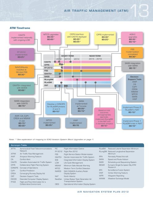
ATM Timeframe<br />
CAATS<br />
implemented nationally<br />
with ongoing LCM<br />
FP 2012<br />
implemented<br />
BO-25*<br />
NAVCANsuite<br />
installed at<br />
Mirabel FSS<br />
B0-30*<br />
GAATS+ integrated<br />
with ADS-B<br />
B0-86*<br />
SASS integration<br />
with CAATS<br />
B0-15*<br />
AWF, CA, CoPr,<br />
CRDA and MSAW<br />
in use<br />
B0-15*<br />
B0-30*<br />
MTCD upgrades<br />
B0-35*<br />
B0-85*<br />
CAATS<br />
CFPS<br />
FP 2012<br />
FSS<br />
GAATS+<br />
SASS<br />
RLongSM<br />
RLatSM<br />
DST<br />
13<br />
AIR TRAFFIC MANAGEMENT (ATM)<br />
CFPS Interface<br />
with CAATS deployed<br />
B0-30*<br />
B0-25*<br />
SHORT-TERM<br />
NEAR-TERM<br />
2012 2013 2014 2015 – 2019<br />
Develop a CONOPS<br />
for RLatSM phases<br />
2 and 3<br />
B0-10*<br />
MTCD<br />
implemented<br />
B0-35*<br />
SARA<br />
implemented<br />
at Toronto<br />
B0-35*<br />
B0-15*<br />
VWF<br />
implemented<br />
B0-70<br />
Note: * See explanation of mapping to ICAO Aviation <strong>System</strong> Block Upgrades on page 1.<br />
Acronym Table<br />
AFTN Aeronautical Fixed Telecommunications<br />
Network<br />
ATFM <strong>Air</strong> Traffic Flow Management<br />
AWF <strong>Air</strong>space Warning Feature<br />
CA Conflict Alert<br />
CAATS Canadian Automated <strong>Air</strong> Traffic <strong>System</strong><br />
CFPS Collaborative Flight <strong>Plan</strong>ning <strong>System</strong><br />
CONOPS Concept of Operations<br />
CoPr Conflict Prediction<br />
CRDA Converging Runway Display Aid<br />
DST Decision Support Tools<br />
EXCDS Extended Computer Display <strong>System</strong><br />
FF-ICE Flight and Flow Information for a<br />
Collaborative Environment<br />
FIC Flight Information Centre<br />
FP 2012 Flight <strong>Plan</strong> 2012<br />
FSS Flight Service Station Modernization<br />
GAATS+ Gander Automated <strong>Air</strong> Traffic <strong>System</strong><br />
IIDS Integrated Information Display <strong>System</strong><br />
LCM Life Cycle Management<br />
MSAW Minimum Safe Altitude Warning<br />
MTCD Medium Term Conflict Detection<br />
NARDS NAV CANADA Auxiliary Radar<br />
Display <strong>System</strong><br />
NAT North Atlantic<br />
NextGen Unites States’ Next Generation <strong>Air</strong><br />
Transportation <strong>System</strong><br />
OIDS Operational Information Display <strong>System</strong><br />
CFPS implemented<br />
B0-30*<br />
B0-25*<br />
Based on trial<br />
outcomes<br />
and appropriate<br />
approvals,<br />
implement RLongSM<br />
in the NAT and<br />
in domestic airspace<br />
B0-10*<br />
AIR NAVIGATION SYSTEM PLAN 2012<br />
ADS-C<br />
upgrades<br />
B0-35*<br />
B0-10*<br />
FSS<br />
modernization<br />
completed<br />
B0-30*<br />
SASS integration<br />
with SARA<br />
B0-15*<br />
Decision<br />
Support Tools<br />
AWF<br />
CA<br />
CoPr<br />
CRDA<br />
MSAW<br />
MTCD<br />
SARA<br />
VWF<br />
Implement Phase 2<br />
RLatSM in NAT<br />
B0-10*<br />
Implement Phase 1<br />
RLatSM trials in NAT<br />
B0-10*<br />
RLatSM Reduced Lateral Separation Minimum<br />
RLongSM Reduced Longitudinal Separation<br />
Minimum<br />
RPA Remotely Piloted <strong>Air</strong>craft<br />
SARA Speed and Route Advisor<br />
SASS Scheduling and Sequencing <strong>System</strong><br />
SESAR Europe’s Single European Sky ATM<br />
Research<br />
SFS Surveillance Fusion <strong>System</strong><br />
VWF Vortex Warning Feature<br />
WPR Waypoint Reporting<br />
WXXM Weather Exchange Model


![[ cac ] canadian airport charts - Nav Canada](https://img.yumpu.com/12328212/1/190x252/-cac-canadian-airport-charts-nav-canada.jpg?quality=85)