6.2.5. Report Favourable region - Central Europe
6.2.5. Report Favourable region - Central Europe
6.2.5. Report Favourable region - Central Europe

Create successful ePaper yourself
Turn your PDF publications into a flip-book with our unique Google optimized e-Paper software.
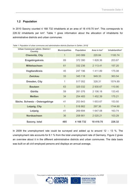
1.2 Population<br />
Transwaste Seite 4<br />
In 2010 Saxony counted 4 168 732 inhabitants at an area of 18 419.70 km². This corresponds to<br />
226.32 inhabitants per km². Table 1 gives information about the allocation of inhabitants for<br />
administrative districts and urban communes.<br />
Table 1: Population of urban communes and administrative districts [Sachsen in Zahlen, 2010]<br />
Urban Commune/ admin. District /<br />
Country<br />
Municipalities Population Area in km² Inhabitant/km²<br />
Chemnitz, City 1 243 089 220.84 1100.74<br />
Erzgebirgskreis 69 372 390 1 828.36 203.67<br />
Mittelsachsen 61 332 236 2 113.41 157.20<br />
Vogtlandkreis 45 247 196 1 411.89 175.08<br />
Zwickau 33 345 118 949.33 363.54<br />
Dresden, City 1 517 052 328.31 1574.89<br />
Bautzen 63 325 032 2 930.67 110.90<br />
Görlitz 59 281 076 2 106.18 133.45<br />
Meißen 34 254 483 1 452.39 175.21<br />
Sächs. Schweiz – Osterzgebirge 41 253 843 1 653.67 153.50<br />
Leipzig, City 1 518 862 297.36 1744.90<br />
Leipzig 41 269 694 1 647.08 163.74<br />
Nordsachsen 36 208 661 2 020.21 103.29<br />
Saxony, total 485 4 168 732 18 419.70 226.32<br />
In 2009 the unemployment rate could be surveyed and added up to around 12 – 13 %. The<br />
unemployment rate accounts for 8.1 % from the total unemployment rate of Germany. Figure 2 gives<br />
an overview about it in the different administrative districts and urban communes. The data basis<br />
was built on all civil employed persons and displays an annual average.