The FlightGear Flight Simulator History, status and future
The FlightGear Flight Simulator History, status and future
The FlightGear Flight Simulator History, status and future

You also want an ePaper? Increase the reach of your titles
YUMPU automatically turns print PDFs into web optimized ePapers that Google loves.
<strong>The</strong> <strong><strong>Flight</strong>Gear</strong> <strong>Flight</strong> <strong>Simulator</strong><br />
<strong>History</strong>, <strong>status</strong> <strong>and</strong> <strong>future</strong><br />
A.R. alex.perry@ieee.org¡<br />
Perry<br />
C. curt@flightgear.org¡<br />
Olson<br />
http://www.flightgear.org/<br />
Abstract<br />
<strong>The</strong> open source flight simulator <strong><strong>Flight</strong>Gear</strong> is being developed through<br />
gracious contributions of source code <strong>and</strong> time by many talented people from<br />
around the globe. <strong>The</strong> main focus of this project is a desire to ‘do things right’,<br />
to minimize short cuts, to learn <strong>and</strong> advance knowledge <strong>and</strong> to have better toys<br />
to play with on ordinary computers.<br />
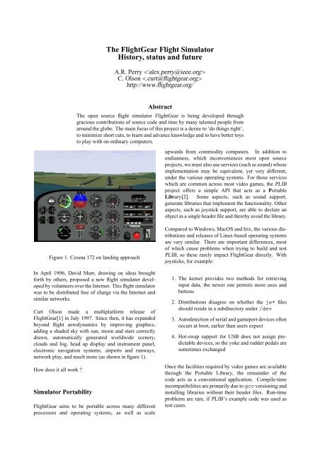
Figure 1: Cessna 172 on l<strong>and</strong>ing approach<br />
In April 1996, David Murr, drawing on ideas brought<br />
forth by others, proposed a new flight simulator developed<br />
by volunteers over the Internet. This flight simulator<br />
was to be distributed free of charge via the Internet <strong>and</strong><br />
similar networks.<br />
Curt Olson made a multiplatform release of<br />
<strong><strong>Flight</strong>Gear</strong>[1] in July 1997. Since then, it has exp<strong>and</strong>ed<br />
beyond flight aerodynamics by improving graphics,<br />
adding a shaded sky with sun, moon <strong>and</strong> stars correctly<br />
drawn, automatically generated worldwide scenery,<br />
clouds <strong>and</strong> fog, head up display <strong>and</strong> instrument panel,<br />
electronic navigation systems, airports <strong>and</strong> runways,<br />
network play, <strong>and</strong> much more (as shown in figure 1).<br />
How does it all work ?<br />
<strong>Simulator</strong> Portability<br />
<strong><strong>Flight</strong>Gear</strong> aims to be portable across many different<br />
processors <strong>and</strong> operating systems, as well as scale<br />
upwards from commodity computers. In addition to<br />
endianness, which inconveniences most open source<br />
projects, we must also use services (such as sound) whose<br />
implementation may be equivalent, yet very different,<br />
under the various operating systems. For those services<br />
which are common across most video games, the PLIB<br />
project offers a simple API that acts as a Portable<br />
Library[2]. Some aspects, such as sound support,<br />
generate libraries that implement the functionality. Other<br />
aspects, such as joystick support, are able to declare an<br />
object in a single header file <strong>and</strong> thereby avoid the library.<br />
Compared to Windows, MacOS <strong>and</strong> Irix, the various distributions<br />
<strong>and</strong> releases of Linux-based operating systems<br />
are very similar. <strong>The</strong>re are important differences, most<br />
of which cause problems when trying to build <strong>and</strong> test<br />
PLIB, so these rarely impact <strong><strong>Flight</strong>Gear</strong> directly. With<br />
joysticks, for example:<br />
1. <strong>The</strong> kernel provides two methods for retrieving<br />
input data, the newer one permits more axes <strong>and</strong><br />
buttons<br />
2. Distributions disagree on whether the js* files<br />
should reside in a subdirectory under /dev<br />
3. Autodetection of serial <strong>and</strong> gameport devices often<br />
occurs at boot, earlier than users expect<br />
4. Hot-swap support for USB does not assign predictable<br />
devices, so the yoke <strong>and</strong> rudder pedals are<br />
sometimes exchanged<br />
Once the facilities required by video games are available<br />
through the Portable Library, the remainder of the<br />
code acts as a conventional application. Compile-time<br />
incompatibilities are primarily due to gcc versioning <strong>and</strong><br />
installing libraries without their header files. Run-time<br />
problems are rare, if PLIB’s example code was used as<br />
test cases.
Any linux user can download the source, compile it <strong>and</strong><br />
safely expect it to run. Unfortunately, you generally<br />
cannot short-cut this process by copying someone else’s<br />
binary. This is a generic problem, encountered by<br />
many applications, <strong>and</strong> led to the Linux St<strong>and</strong>ards Base<br />
project[3].<br />
It is made many times worse for <strong><strong>Flight</strong>Gear</strong> because<br />
hardware differences force library selections to be modified<br />
so that a given binary may not even be usable on<br />
another machine with the same Linux distribution <strong>and</strong><br />
release if it has a different graphics card (for example).<br />
This is especially true with GL support, the extensions,<br />
<strong>and</strong> the level of GLX implementation available. This<br />
is being addressed by the Linux OpenGL Application<br />
Binary Interface (ABI)[4].<br />
<strong>Simulator</strong> Structure<br />
Current commercial PC flight simulators are proprietary,<br />
lack extensibility <strong>and</strong> thus are resistant to modification<br />
<strong>and</strong> enhancement. If the <strong><strong>Flight</strong>Gear</strong> project wishes to fill<br />
the gap, it must provide a flexible framework.<br />
<strong>The</strong> <strong><strong>Flight</strong>Gear</strong> source tree is only one level deep, except<br />
that all the flight data models are each in their own<br />
subdirectory located under the FDM directory. Each<br />
directory contains a few header files that expose its<br />
object definitions. Other source files refer to the headers<br />
directly, without path globbing or multiple include paths<br />
for the compiler. <strong>The</strong> directory names are mostly pretty<br />
self-explanatory:<br />
Aircraft, Airports, Autopilot, Time (in the simulated<br />
world), Cockpit, Controls (in the aircraft cockpit), FDM<br />
(only one constituent in use), GUI (menus <strong>and</strong> the<br />
like), Include (for compiler configuration), Joystick,<br />
Main (initialization <strong>and</strong> comm<strong>and</strong> line parsing), Network<br />
(data sharing), NetworkOLK (network play), Objects<br />
(dynamically loaded <strong>and</strong> changing scenery), Scenery<br />
(static), Weather (world wide basic factors), WeatherCM<br />
(four dimensional world database), Navaids, Ephemeris<br />
(of celestial bodies) <strong>and</strong> Sound.<br />
In addition to the collection of interacting objects, <strong>Flight</strong>-<br />
Gear also exposes the high level state of the simulation in<br />
two ways. First, a meta-object BFI provides a long list of<br />
methods to retrieve (<strong>and</strong>, in some cases, modify) popular<br />
information that is distributed around the many different<br />
types of objects. This avoids making each source file<br />
dependent on the declarations of almost every object type<br />
<strong>and</strong> header file. <strong>The</strong>se references <strong>and</strong> interactions can<br />
only really be modified at compile time.<br />
<strong>The</strong> second exposure of the simulator state occurs<br />
through the property database, which dynamically maps a<br />
name (such as /position/latitude) into an object<br />
with getter <strong>and</strong> setter methods. Although slower, the<br />
dynamic access is especially appropriate for the user<br />
interface, parametric graphics elements <strong>and</strong> configuration<br />
files.<br />
<strong>The</strong> property database is also exposed to other applications<br />
by the network interface. <strong>The</strong> comm<strong>and</strong> line option<br />
--props=socket,bi,20,,5555,tcp, for example,<br />
allows someone else (such as the flight instructor)<br />
to run telnet localhost 5555. This allows<br />
arbitrary properties to be viewed <strong>and</strong> modified while the<br />
simulation is running.<br />
Many tasks within the simulator need to only run<br />
periodically. <strong>The</strong>se are typically tasks that calculate<br />
values that don’t change significantly in 1/60th of a<br />
second, but instead change noticeably on the order of<br />
seconds, minutes, or hours. Running these tasks every<br />
iteration would needless degrade performance. Instead,<br />
we would like to spread these out over time to minimize<br />
the impact they might have on frame rates, <strong>and</strong> minimize<br />
the chance of pauses <strong>and</strong> hesitations.<br />
We do this using the Periodic Event Manager <strong>and</strong><br />
Scheduler, which consists of two parts. <strong>The</strong> first part<br />
is simply a list of registered events along with any<br />
management information associated with that event. <strong>The</strong><br />
second part is a run queue. When events are triggered,<br />
they are placed in the run queue. <strong>The</strong> system executes<br />
only one pending event per iteration in order to balance<br />
the load. <strong>The</strong> manager also acquires statistics about event<br />
execution such as the total time spent running this event,<br />
the quickest run, the slowest run, <strong>and</strong> the total number<br />
of times run. We can output the list of events along with<br />
these statistics in order to determine if any of them are<br />
consuming an excessive amount of time, or if there is any<br />
chance that a particular event could run slow enough to<br />
be responsible for a perceived hesitation or pause in the<br />
flow of the simulation.<br />
<strong>Simulator</strong> Execution<br />
Installing <strong>and</strong> running <strong><strong>Flight</strong>Gear</strong> is relatively easy under<br />
Linux, especially compared to other operating systems<br />
with weak tool automation.<br />
1. Install Linux normally <strong>and</strong> test internet access.<br />
2. Add video card support, using a maximum of 25%<br />
of memory for 2D display.<br />
3. Enable hardware accelerated OpenGL support <strong>and</strong><br />
test for speed, using glTron[5] for example.<br />
4. Install PLIB 1.2 or above, which is already in<br />
many distributions, <strong>and</strong> test with all the supplied<br />
examples to ensure the API is working.<br />
5. Download, compile <strong>and</strong> install SimGear. If your<br />
distribution already includes some components,<br />
such as zlib, verify that headers are present.
Figure 2: Panoramic scenery<br />
6. While that compiles, download the <strong><strong>Flight</strong>Gear</strong><br />
source. Once SimGear is installed, start the<br />
compile <strong>and</strong> then install it<br />
7. While the simulator is compiling, download <strong>Flight</strong>-<br />
Gear’s base package. This contains data files that<br />
are required to execute the binary application.<br />
8. Type runfgfs <strong>and</strong> enjoy.<br />
For a computer system which is directly supported by<br />
your chosen distribution, the first five steps are often<br />
trivialized into telling the installer to ensure ‘plib-dev’ is<br />
present. Starting from a blank hard drive, <strong><strong>Flight</strong>Gear</strong> can<br />
be running in less than an hour.<br />
Simulating the Pilot<br />
<strong>The</strong> new <strong><strong>Flight</strong>Gear</strong> pilot will probably not want to<br />
remain within the San Francisco bay area, which is the<br />
small scenery patch included in the Base package. <strong>The</strong><br />
scenery server allows the selection <strong>and</strong> retrieval of any<br />
region of the world. Joining other users in the sky is<br />
another possibility.<br />
In a large group of users, coordinating the position <strong>and</strong><br />
activities of all the players requires considerable network<br />
traffic, which can degrade the apparent performance.<br />
<strong>The</strong> <strong><strong>Flight</strong>Gear</strong> Deamon, fgd, is a st<strong>and</strong>alone program<br />
which can run on a separate computer that is independent<br />
of any <strong><strong>Flight</strong>Gear</strong> session. It registers FGFS players<br />
willing to take part in a multiplayer FGFS environment<br />
via TCP/IP. Information like the player’s IP/lon/lat/alt<br />
<strong>and</strong> inter-player messages can be sent to fgd, which in<br />
turn sends back the gathered information upon request.<br />
In this way, the simulated aircraft all become visible to<br />
each other.<br />
Due to limited monitor size, the view that is available<br />
on a normal computer is more like the little passenger<br />
portholes on airlines <strong>and</strong> a poor substitute for the<br />
wraparound windows of general aviation aircraft. This<br />
is especially true when the simulated aircraft has an open<br />
cockpit <strong>and</strong> an unrestricted view in almost all directions.<br />
To alleviate the problem with lack of external view,<br />
<strong><strong>Flight</strong>Gear</strong> supports synchronizing several displays together<br />
to form a panoramic or wrap around view.<br />
<strong><strong>Flight</strong>Gear</strong> has built in support for network socket<br />
communication <strong>and</strong> the display synchronzing is built on<br />
top of this support. <strong><strong>Flight</strong>Gear</strong> also supports a null or<br />
do-nothing flight model which expects the flight model<br />
parameters to be updated somewhere else in the code.<br />
Combining these two features allows you to synchronize<br />
displays.<br />
For example, let’s assume we want to setup the example<br />
shown in figure 2.<br />
1. Ideally, configure three identical computers <strong>and</strong><br />
monitors.<br />
2. Pick one of the computers (i.e. the center channel)<br />
to be the master. <strong>The</strong> left <strong>and</strong> right will be slaves<br />
s1 <strong>and</strong> s2.<br />
3. When you start runfgfs on the master, use the<br />
comm<strong>and</strong> line options<br />
--native=socket,out,60,s1,5500,udp<br />
--native=socket,out,60,s2,5500,udp<br />
respectively to specify that we are sending the<br />
“native” protocol out of a udp socket channel at<br />
60 Hz, to a slave machine on port 5500.<br />
4. When you start runfgfs on each of the<br />
slave computers, use the comm<strong>and</strong> line option<br />
--native=socket,in,60,,5500,udp to<br />
specify that we expect to receive the native protocol<br />
via a udp socket on port 5500. <strong>The</strong> second<br />
option --fdm=external tells the slave not to<br />
run it’s own flight model math, but instead receive<br />
the values from an “external” source.<br />
5. You need to ensure that the field of view on the<br />
scenery matches the apparent size of the monitor to<br />
the pilot. --fov=xx.x allows you to specify the<br />
field of view in degrees on each computer display<br />
individually.<br />
6. --view-offset=xx.x allows you to specify<br />
the view offset direction in degrees. For instance,<br />
--view-offset=0 for the center channel,<br />
--view-offset=-50 for slave 1, <strong>and</strong><br />
--view-offset=50 for slave 2.<br />
<strong>The</strong>re is no built in limit to the number of slaves you<br />
may have. It wouldn’t be too hard to implement a full<br />
360 degree wrap around display using 6 computers <strong>and</strong><br />
6 projectors, each covering 60 degree field of view on a<br />
cylindrical projection screen.<br />
Simulating the Aircraft<br />
<strong>The</strong> aerodynamic simulation may be only one constituent<br />
of the whole environment being simulated for the user,
Figure 3: Tux flying over Woods Hole<br />
but its performance is critical to the quality of the user’s<br />
simulation experience. Errors in this <strong>Flight</strong> Dynamics<br />
Model (FDM) are distracting to the pilot. Other<br />
simulator components, such as the autopilot, are designed<br />
to expect a realistic aircraft, may respond incorrectly<br />
as a result of FDM errors <strong>and</strong> provide additional pilot<br />
distractions. <strong>The</strong>se factors can ruin the immersive<br />
experience that the user is seeking.<br />
As a result of this concern, <strong><strong>Flight</strong>Gear</strong> abstracts all of the<br />
code that implements an FDM behind an object oriented<br />
interface. As <strong>future</strong> applications find that existing FDM<br />
choices do not meet their requirements, additional FDM<br />
code can be added to the project without impacting the<br />
consistent performance of existing applications.<br />
<strong>The</strong> original FDM was LaRCsim, which models a Cessna<br />
172 using dedicated C source that has the necessary<br />
coefficients hard coded. It is sufficient for most flight<br />
situations that a passenger would choose to experience<br />
in a real aircraft. Unusual maneuvers that are often<br />
intentionally performed for training purposes are poorly<br />
modelled, including deep stalls, incipient <strong>and</strong> developed<br />
spins <strong>and</strong> steep turns. <strong>The</strong> code also supports a Navion<br />
<strong>and</strong> a Cherokee, to a similar quality.<br />
A research group at the University of Illinois created<br />
a derivative of LaRCsim, with simplified the models<br />
such that they are only really useful for cruise flight<br />
regimes. <strong>The</strong>y enhanced the code with a parametric<br />
capability, such that a configuration file could be selected<br />
at simulation start to determine how the aircraft will fly.<br />
<strong>The</strong>ir use for this modification was to investigate the<br />
effect on aircraft h<strong>and</strong>ling of progressive accumulations<br />
of ice.<br />
Another group is developing a completely parametric<br />
FDM code base, where all the information is retrieved<br />
from XML format files. <strong>The</strong>ir JSBSim project[6] can<br />
run independently of a full environmental simulation,<br />
to examine aerodynamic h<strong>and</strong>ling <strong>and</strong> other behavior.<br />
An abstraction layer links the object environment of<br />
<strong><strong>Flight</strong>Gear</strong> to the object collection of JSBSim to provide<br />
an integrated system. Currently, this FDM supports the<br />
Cessna 172 <strong>and</strong> the X-15 (a hypersonic rocket propelled<br />
research vehicle), providing the contrast between an<br />
aircraft used for teaching new student pilots <strong>and</strong> an<br />
aircraft that could only be flown by highly trained test<br />
pilots.<br />
<strong>The</strong> rest of <strong><strong>Flight</strong>Gear</strong>’s configuration files are also<br />
moving towards XML, such as the engine models, the<br />
instrument panel layouts <strong>and</strong> instrument design, the<br />
HUD layout, the user preferences <strong>and</strong> saved state. <strong>The</strong><br />
real benefit of using XML here is that people with<br />
no software development experience can easily <strong>and</strong><br />
effectively contribute. Pilots, instructors, maintenance<br />
technicians <strong>and</strong> researchers all have in-depth technical<br />
knowledge of how an aircraft <strong>and</strong> hence the simulator<br />
should behave, so it is critical that we allow them direct<br />
access to the internals.<br />
Both the head up display (HUD) <strong>and</strong> the instrument panel<br />
allow the user to specify an XML file describing which<br />
instruments are to be displayed <strong>and</strong> where they should<br />
be located on-screen. Individual instruments are defined<br />
in independent XML files, selecting graphic elements,<br />
texture bitmaps <strong>and</strong> transforms that modify these to build<br />
the desired effect. Some of the transforms are fixed<br />
<strong>and</strong> others are parametric on simulator data, so that<br />
the rotation angle of a needle bitmap on the airspeed<br />
instrument is determined by the computed airspeed value<br />
inside the FDM section of the simulator.<br />
<strong>The</strong> head up display of a real aircraft uses computer<br />
generated graphics, so the software can generally detect,<br />
<strong>and</strong> correct for, the flaws <strong>and</strong> inaccuracies in the sensors<br />
that are feeding it data. As a result, the information<br />
presented to the pilot is generally accurate. Simulating<br />
that is relatively easy, since the actual state of the aircraft<br />
can be retrieved <strong>and</strong> directly displayed.<br />
An important aspect of learning to fly an aircraft (without<br />
computer assistance) is underst<strong>and</strong>ing what the limitations<br />
<strong>and</strong> errors of the various instruments are, <strong>and</strong> when<br />
their indications can be trusted as useful flight data.<br />
Unfortunately, the information from panel instruments<br />
has errors, which in general only read a single sensor<br />
value with negligible correction for the limitations of<br />
the sensors being used. When the <strong><strong>Flight</strong>Gear</strong> panel<br />
advanced from no errors to having only two of the<br />
limitations implemented, the non-pilot developers went<br />
from trivially flying instrument approaches to frequent<br />
ground impacts.<br />
Considerable effort is needed to write this code. Gyroscopes<br />
can slow down <strong>and</strong> wobble, their rotation axis<br />
can drift, they can hit gimbal stops <strong>and</strong> tumble <strong>and</strong> their
power source can be weak or fail. Air-based instruments<br />
are wrong in certain weather conditions, tend not to<br />
respond immediately, can be blocked by rainwater in<br />
the lines, or become unusable when iced over. Radio<br />
navigation is subject to line-of-sight, signals bounce off<br />
hills <strong>and</strong> bend near lake shores or where another aircraft<br />
is in the way <strong>and</strong> distant stations can interfere. Still<br />
more errors are associated with the magnetic compass,<br />
<strong>and</strong> other instruments that seem ’trivial’.<br />
Currently, the communication radios are not implemented,<br />
so that pilots cannot use their microphone inputs<br />
to interact. Radio usage is a large part of the complexity<br />
in operating at large <strong>and</strong> busy airports. Unfortunately,<br />
this often encourages pilots to fly the microphone <strong>and</strong><br />
forget about the airplane, occasionally with disastrous<br />
results. We hope to implement this feature soon, to<br />
provide another source of challenging distractions to the<br />
pilot.<br />
Simulating the World<br />
<strong>The</strong> purpose of the TerraGear project[7] is to develop<br />
open-source tools <strong>and</strong> rendering libraries <strong>and</strong> collect free<br />
data for building 3D representations (or maps) of the<br />
earth for use in real time rendering projects. <strong>The</strong>re is<br />
much freely available Geographic Information System<br />
(GIS) data on the internet. Because the core data for<br />
<strong><strong>Flight</strong>Gear</strong> has to be unrestricted, the default use of<br />
the project only uses source data that doesn’t impose<br />
restrictions on derivative works. Three categories of data<br />
are used.<br />
Digital Elevation Model (DEM) data is typically a set<br />
of elevation points on a regular grid. Currently, 30<br />
arcsecond (about ¢¤£¦¥¨§�©�� ��¥�� ) data for the whole<br />
world, <strong>and</strong> 3 arcsecond (about ¢�©�©�¥�§���©�©���� ) data for<br />
the United States, is available from the USGS, but better<br />
data sources are hoped for. An optimizing algorithm<br />
seeks to find the smallest number of flat triangles that<br />
provide a fairly smooth <strong>and</strong> realistic terrain contour.<br />
This algorithm reduces the number of triangles need to<br />
render an area while preserving all the detail within some<br />
specified error tolerance.<br />
Other more specialized data such as airport beacon,<br />
lighthouse locations, radio transmission towers <strong>and</strong> the<br />
like are available in listings from various government<br />
agencies. <strong>The</strong>se generally provide a short text description<br />
of the item <strong>and</strong> its geographic coordinates. <strong>The</strong> challenge<br />
is to convert each entry into a realistic visual object which<br />
can be inserted into the scenery database.<br />
Polygonal data such as l<strong>and</strong>mass outlines, lakes, isl<strong>and</strong>s,<br />
ponds, urban areas, glaciers, l<strong>and</strong> use <strong>and</strong> vegetation<br />
are available from the USGS <strong>and</strong> other sources. <strong>The</strong><br />
GSHHS database provides a highly detailed <strong>and</strong> accurate<br />
global l<strong>and</strong> mass data so we can model precise coast<br />
Figure 4: World scenery<br />
lines for the entire world. Based on the source of<br />
the data <strong>and</strong> factoring in the l<strong>and</strong> use data, we can<br />
select an appropriate texture which will be painted onto<br />
the individual triangles. Where necessary, triangles<br />
are subdivided to get the effect correct. Runways <strong>and</strong><br />
taxiways are generated by converting the list of runway<br />
segments into polygons, painted with appropriate surface<br />
texture <strong>and</strong> markings, <strong>and</strong> then integrated into the scenery<br />
in the same way.<br />
Clearly, someone can gain access to data sources that are<br />
under more restrictive licenses, use the TerraGear project<br />
tools to generate enhanced scenery <strong>and</strong> then distribute<br />
those files as they choose. Both the <strong><strong>Flight</strong>Gear</strong> <strong>and</strong><br />
TerraGear projects encourage this kind of enhancement,<br />
because the basic open source packages cannot do this.<br />
<strong>The</strong>re is a trade-off between the quality of the scenery<br />
<strong>and</strong> the speed at which it can be rendered by the graphics<br />
card. As cards get faster, it becomes feasible to place<br />
more detail into the scenery while maintaining a useful<br />
<strong>and</strong> smooth visual effect. <strong>The</strong>re are many techniques for<br />
adjusting the level of detail according to the altitude <strong>and</strong><br />
attitude of the aircraft, to optimize the visual quality, but<br />
none of them are currently implemented as they cause<br />
visual artifacts.<br />
Currently, the visual effect is clearly synthetic, as can<br />
be seen in figure 3, but it has sufficient information to<br />
readily permit navigation by pilotage (i.e. comparing the<br />
view out of the window to a chart). <strong>The</strong> compressed data<br />
requires about one kilobyte per square kilometer. All the<br />
information inside the scenery database is arranged in a<br />
four-level hierarchy, where each level changes scale by a<br />
factor between 10 <strong>and</strong> 100:<br />
1. One planet, currently only the Earth<br />
2. ¢�©�����¢�©�� rectangle as shown in figure 4,<br />
3. ¢�����¢�������©�¥�������©�¥���§�¢�©�©�£¦¥�����©�£¦¥ ,<br />
4. ��©�¥�����§�¢�©�©�£¦¥�� approximately.
One of the difficulties facing the TerraGear developers<br />
is that most information sources are only generated at a<br />
national level. It is easy to justify writing special code to<br />
read <strong>and</strong> process data files for the largest ten countries,<br />
since they cover most of the l<strong>and</strong> surface of the planet,<br />
but this approach rapidly reaches the point of diminishing<br />
returns.<br />
<strong>The</strong>re are already many organizations that painstakingly<br />
collect <strong>and</strong> transform the data into st<strong>and</strong>ardized formats,<br />
precisely for these kinds of applications. However, the<br />
huge amount of effort involved requires them to keep the<br />
prices extremely high in order to fund the conversions.<br />
<strong>The</strong>refore, in the medium term, it is possible that these<br />
organizations (or one of their licensees) may start selling<br />
TerraGear compatible scenery files that is derived from<br />
their data archive. You can expect a high price tag for<br />
such reliable data though.<br />
Data that is released into the public domain is generally<br />
of reduced quality, or out of date, or does not give<br />
widespread area coverage. <strong>The</strong> scenery generated from<br />
such data is actually wrong, compared to the real<br />
world, but generally only in ways that are visually<br />
unobtrusive. <strong>The</strong>se errors are more visible in electronic<br />
navigation, such as needed for instrument flight, since<br />
the route tolerances are extremely tight. Navigating the<br />
simulated aircraft around imperfect scenery according to<br />
current Jeppesen (or NOS, etc) charts can be extremely<br />
frustrating <strong>and</strong> occasionally impossible when a piece of<br />
scenery is in the way.<br />
To avoid the frustration, the Atlas project[8] has developed<br />
software which automatically synthesizes aviation<br />
style charts from the actual scenery files <strong>and</strong> databases<br />
being used by <strong><strong>Flight</strong>Gear</strong>. Thse charts, while inaccurate<br />
to the real world <strong>and</strong> therefore useless for flight in an<br />
aircraft, are extremely accurate for the simulated world<br />
in which the <strong><strong>Flight</strong>Gear</strong> aircraft operate. Thus, it is often<br />
easier to make printouts from the Map program of the<br />
Atlas project.<br />
<strong>The</strong> project also includes the namesake Atlas application.<br />
This can be used for browsing those maps <strong>and</strong> can<br />
also connect directly to <strong><strong>Flight</strong>Gear</strong> in order to display<br />
aircraft current location on a moving map display. This<br />
capability must be used selectively by the simulator pilot,<br />
since most small aircraft do not contain GPS units with<br />
integrated moving map displays ... yet. However, the<br />
moving map is invaluable to instructors for gauging<br />
student performance.<br />
<strong>The</strong> connection between <strong><strong>Flight</strong>Gear</strong> <strong>and</strong> Atlas is a special<br />
case of their general capabilities. <strong><strong>Flight</strong>Gear</strong> can emit a<br />
stream of NMEA compliant position reports (the format<br />
used by GPS units) to serial port or UDP socket. Atlas<br />
can receive NMEA format position data <strong>and</strong> adjust the<br />
moving map image. <strong>The</strong> user who is browsing the chart<br />
atlas can zoom in <strong>and</strong> out, toggle the display of airports,<br />
Figure 5: Chart of San Diego, California<br />
navigational stations, terrain tint <strong>and</strong> name overlays.<br />
<strong>Simulator</strong> Status<br />
We have a wide range of people interested <strong>and</strong> participating<br />
in this project. This is truly a global effort with<br />
contributors from just about every continent. Interests<br />
range from building a realistic home simulator out old<br />
airplane parts, to university research <strong>and</strong> instructional<br />
use, to simply having a viable alternative to commercial<br />
PC simulators. Here are some current uses:<br />
1. University of Illinois at Urbana Champaign.<br />
<strong><strong>Flight</strong>Gear</strong> is providing a platform for icing research<br />
for the Smart Icing Systems Project.<br />
2. Simon Fraser University, British Columbia Canada.<br />
Portions of <strong><strong>Flight</strong>Gear</strong> were used in simulation<br />
to develop the needed control algorithms for<br />
an autonomous aerial vehicle.<br />
3. Iowa State University. A senior project intended to<br />
retrofit some older sim hardware with <strong><strong>Flight</strong>Gear</strong><br />
based software.<br />
4. University of Minnesota - Human Factors Research<br />
Lab. <strong><strong>Flight</strong>Gear</strong> brings new life to an old<br />
Agwagon single seat, single engine simulator.<br />
5. Aeronautical Development Agency, Bangalore India.<br />
<strong><strong>Flight</strong>Gear</strong> is used as as the image generator<br />
for a flight simulation facility for piloted evaluation<br />
of ski-jump launch <strong>and</strong> arrested recovery of a<br />
fighter aircraft from an aircraft carrier.
6. Veridian Engineering Division, Buffalo, NY.<br />
<strong><strong>Flight</strong>Gear</strong> is used for the scenery <strong>and</strong> out-thewindow<br />
view for the Genesis 3000 flight simulator.<br />
Reselling open source software has not been a good<br />
revenue source for other companies, partly because of<br />
the rapid version changes <strong>and</strong> partly because of the<br />
low cost of b<strong>and</strong>width for the consumer. Yet, several<br />
organizations are also considering making retail versions.<br />
Can <strong><strong>Flight</strong>Gear</strong> be a viable profit center?<br />
Suppose we separate the database of visual scenery<br />
from everything else. That everything else is only few<br />
megabytes, which easily fits into a corner of a CD <strong>and</strong><br />
will readily be downloaded whenever a new version<br />
becomes available. As with many other GUI packages,<br />
it will probably be repackaged by the distributions to<br />
ensure a painless installation for the community. <strong>The</strong>re<br />
appears to be little benefit in making a product here,<br />
especially since closed source flight simulator games are<br />
available at under ����© .<br />
In contrast, the scenery is more than a gigabyte for each<br />
continent, is unlikely to get any smaller, <strong>and</strong> represents<br />
a significant download. <strong>The</strong> scenery is relatively stable<br />
over time, old versions are usually useful with newer<br />
releases of the binary software, <strong>and</strong> the upgrades only<br />
add detail to an existing <strong>and</strong> viable database. <strong>The</strong>re is<br />
clearly an opportunity to retail a DVD (or a dozen CDs)<br />
that contain the scenery. <strong>The</strong> marginal cost of adding<br />
a few dozen binaries, for popular operating system<br />
distributions <strong>and</strong> driver combinations, is probably trivial.<br />
Thus, this retail package is likely to be fully functional.<br />
Alternatively, suppose we consider the pilot’s viewpoint.<br />
Most general aviation aircraft cruise at below 200 knots<br />
<strong>and</strong> flight visibility is (in real life) usually below 20<br />
miles for the lower altitudes that are accessible with<br />
ordinary non-turbocharged piston engines. Even when<br />
flying in a straight line, a maximum of 8000 square<br />
miles of new terrain will come into view during each<br />
hour of flight. Currently, the database uses about one<br />
megabyte for 600 square miles, so a streaming rate of 12<br />
megabytes/hour will be sufficient. <strong>The</strong> rate will be lower<br />
when previously-downloaded scenery is in view.<br />
This need not impact the core <strong><strong>Flight</strong>Gear</strong> source code.<br />
<strong>The</strong> latitude <strong>and</strong> longitude of the aircraft are already<br />
exported for use by independent programs, so the center<br />
of interest is trivially available. Since the scenery is<br />
stored in ¢�©�©�£¦¥�� pieces, an independent program need<br />
only generate a list of the closest elements that have not<br />
been fetched yet, <strong>and</strong> issue a wget to ensure that they<br />
will be available before the aircraft gets close enough for<br />
the pilot to see them.<br />
A 56K modem is capable of 12 megabytes per hour<br />
before compression. If streaming scenery can be delivered<br />
essentially through any internet connection, it might<br />
remove the market need for retail scenery packages.<br />
Multiplying this b<strong>and</strong>width by a worldwide community<br />
of users will result in a sizeable traffic impact on the<br />
distributing servers. Is the total still going to be low<br />
enough to be supported for goodwill, or will free servers<br />
gradually transition to monthly access fees <strong>and</strong> maybe<br />
even deliver proprietary content?<br />
Simulating <strong>Flight</strong> Training<br />
<strong><strong>Flight</strong>Gear</strong> could also be helpful when learning to fly<br />
aircraft. <strong>Flight</strong> training is carefully regulated by the<br />
government, to ensure that aircraft generally stay in the<br />
sky until their pilot intends for them to come down safely.<br />
<strong>The</strong>re are thus some real concerns which need to be<br />
addressed before authorities can approve a system.<br />
1. Do the controls feel, <strong>and</strong> operate, sufficiently like<br />
the ones in the aircraft that a pilot can use them<br />
without confusion? Are they easier to use <strong>and</strong>/or<br />
do they obscure dangerous real-life effects?<br />
2. Does the software provide a forward view that<br />
is representative for the desired training environment?<br />
3. Are the instruments drawn such that a pilot can<br />
easily read <strong>and</strong> interpret them as usual? Do<br />
they have the systematic errors that often cause<br />
accidents?<br />
4. Can all needed cockpit switches <strong>and</strong> knobs be<br />
operated intuitively?<br />
5. When operated in the limited envelope of flight<br />
configurations that is applied to the training activity,<br />
does it match the manufacturer’s data for the<br />
aircraft performance?<br />
6. Are the weather settings accessible <strong>and</strong> intuitive to<br />
the instructor? How about causing system failures<br />
<strong>and</strong> broken instrumentation?<br />
7. Can the pilot conduct normal interactions with air<br />
traffic control? Can the instructor easily determine<br />
whether the pilot is complying with the control instructions<br />
<strong>and</strong> record errors for subsequent review?<br />
8. Is the pilot’s manual for the simulator similar <strong>and</strong><br />
arrangement to that of an aircraft, such that it can<br />
readily be used in flight?<br />
9. Can all maneuvers be performed in the same way<br />
as in an aircraft?<br />
In that (partial) list of concerns, the quality of the actual<br />
flight simulation (which is really what <strong><strong>Flight</strong>Gear</strong> is<br />
offering) is a minor topic <strong>and</strong> <strong>and</strong> acceptable performance<br />
is easily achieved. In contrast, a large package of
documentation must be added to the software to explain<br />
<strong>and</strong> teach people how to use it correctly. This has led to<br />
a separate project FGATD[9], whose goal is to initially<br />
meet the lowest st<strong>and</strong>ard created by the United States<br />
Federal Aviation Administration (FAA). Don’t expect it<br />
to finish soon.<br />
It is easy to suggest that the FAA is being unrealistic in<br />
requiring this documentation, but they are responding to<br />
important traits in human nature that won’t go away just<br />
because they’re inconvenient.<br />
For example, the things learnt first leave an almost<br />
unshakeable impression <strong>and</strong>, at times of severe stress,<br />
will over-rule later training. Thus, any false impressions<br />
that are learned by a beginning student through using a<br />
simulator will tend to remain hidden until a dangerous<br />
<strong>and</strong> potentially lethal situation is encountered, at which<br />
time the pilot may react wrongly <strong>and</strong> die. Pilots who use<br />
a simulator on an ongoing basis to hone their skills will<br />
get an excessively optimistic opinion of their skills, if the<br />
simulator is too easy to fly or does not exhibit common<br />
flaws. As a result, they will willingly fly into situations<br />
that are in practice beyond their skill proficiency <strong>and</strong> be<br />
at risk.<br />
Clearly, a flight simulator (such as <strong><strong>Flight</strong>Gear</strong>) can only<br />
safely be used for training when under the supervision of<br />
a qualified instructor, who can judge whether the learning<br />
experience is beneficial. <strong>The</strong> documentation materials<br />
are essential to supporting that role.<br />
What’s in the <strong>future</strong>?<br />
As with any Open Source project, there are as many<br />
possible <strong>future</strong>s as there are users <strong>and</strong> developers of the<br />
code. Some areas to think about are:<br />
<strong>The</strong> aerodynamic models are not (yet) accurate enough<br />
for use in all flight situations, so they don’t reflect the<br />
challenges <strong>and</strong> excitement of acrobatic maneuvering.<br />
<strong>The</strong> models also don’t react like a Cessna 172, which is<br />
not designed or certified for such maneuvers.<br />
Surround projectors, head mounted displays, directional<br />
sound <strong>and</strong> cockpit motion are rapidly converging into<br />
consumer technologies. Maybe we can immerse the users<br />
so well that they fly conservatively because they forget<br />
that they’re not in real danger.<br />
Recent radar <strong>and</strong> visual satellite surveys of the earth’s<br />
surface have enough detail to be directly used as photorealistic<br />
scenery. But not until someone figures out how to<br />
manipulate terabytes in real time, since the data volume<br />
is about a million times larger than now.<br />
<strong>The</strong> aircraft wake is invisible, can last five minutes,<br />
descends slowly or spreads across the ground, is blown<br />
around by the wind <strong>and</strong> is extremely dangerous to<br />
following aircraft. A <strong>future</strong> extension to fgd could<br />
keep track of the hundreds of miles of wake trails in a<br />
given area <strong>and</strong> notify individual aircraft when they are<br />
encountering invisible severe turbulence.<br />
Replication <strong>and</strong> scalability is only starting to take hold<br />
in the desktop environment. A room of several hundred<br />
computers acting as X terminals for word processing can<br />
reboot <strong>and</strong>, within a couple of minutes, all be running<br />
<strong><strong>Flight</strong>Gear</strong> identically. <strong>The</strong>y’re ready for the next class<br />
of student pilots.<br />
Conclusions<br />
On the surface, <strong><strong>Flight</strong>Gear</strong> is a simple Open Source<br />
project that builds on many existing projects in the community<br />
traditions. Due to the subject it addresses, many<br />
issues <strong>and</strong> concerns are raised that rarely inconvenience<br />
most other project teams. <strong>The</strong>se elements are providing<br />
the exciting challenges <strong>and</strong> variety of associated activities<br />
that the developer team is enjoying.<br />
References<br />
[1] http://www.flightgear.org/<br />
[2] http://plib.sourceforge.net/<br />
[3] http://www.linuxbase.org/<br />
[4] http://oss.sgi.com/projects/ogl-sample/ABI/<br />
[5] http://www.gltron.org/<br />
[6] http://www.jsbsim.org/<br />
[7] http://www.terragear.org/<br />
[8] http://atlas.sourceforge.net/<br />
[9] http://fgatd.sourceforge.net/<br />
About the authors:<br />
Alex<strong>and</strong>er Perry holds M.A. <strong>and</strong> Ph.D. degrees in engineering from<br />
Cambridge University in Engl<strong>and</strong> <strong>and</strong> currently works as a senior<br />
research engineer for Quantum Magnetics in San Diego. He is one<br />
of the <strong><strong>Flight</strong>Gear</strong> developers, a commercial <strong>and</strong> instrument rated pilot,<br />
ground instructor <strong>and</strong> an aviation safety counselor in San Diego <strong>and</strong><br />
Imperial counties of California.<br />
Curtis Olson holds a M.S. degree in computer science from the<br />
University of Minnesota. He currently works as a simulation engineer<br />
at the Human Factors Research Lab of the University of Minnesota<br />
developing <strong>and</strong> support their research driving simulators. He is the<br />
<strong><strong>Flight</strong>Gear</strong> project leader <strong>and</strong> also a major developer.