The FlightGear Flight Simulator History, status and future
The FlightGear Flight Simulator History, status and future
The FlightGear Flight Simulator History, status and future

Create successful ePaper yourself
Turn your PDF publications into a flip-book with our unique Google optimized e-Paper software.
One of the difficulties facing the TerraGear developers<br />
is that most information sources are only generated at a<br />
national level. It is easy to justify writing special code to<br />
read <strong>and</strong> process data files for the largest ten countries,<br />
since they cover most of the l<strong>and</strong> surface of the planet,<br />
but this approach rapidly reaches the point of diminishing<br />
returns.<br />
<strong>The</strong>re are already many organizations that painstakingly<br />
collect <strong>and</strong> transform the data into st<strong>and</strong>ardized formats,<br />
precisely for these kinds of applications. However, the<br />
huge amount of effort involved requires them to keep the<br />
prices extremely high in order to fund the conversions.<br />
<strong>The</strong>refore, in the medium term, it is possible that these<br />
organizations (or one of their licensees) may start selling<br />
TerraGear compatible scenery files that is derived from<br />
their data archive. You can expect a high price tag for<br />
such reliable data though.<br />
Data that is released into the public domain is generally<br />
of reduced quality, or out of date, or does not give<br />
widespread area coverage. <strong>The</strong> scenery generated from<br />
such data is actually wrong, compared to the real<br />
world, but generally only in ways that are visually<br />
unobtrusive. <strong>The</strong>se errors are more visible in electronic<br />
navigation, such as needed for instrument flight, since<br />
the route tolerances are extremely tight. Navigating the<br />
simulated aircraft around imperfect scenery according to<br />
current Jeppesen (or NOS, etc) charts can be extremely<br />
frustrating <strong>and</strong> occasionally impossible when a piece of<br />
scenery is in the way.<br />
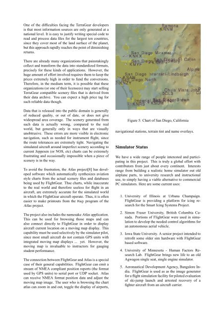
To avoid the frustration, the Atlas project[8] has developed<br />
software which automatically synthesizes aviation<br />
style charts from the actual scenery files <strong>and</strong> databases<br />
being used by <strong><strong>Flight</strong>Gear</strong>. Thse charts, while inaccurate<br />
to the real world <strong>and</strong> therefore useless for flight in an<br />
aircraft, are extremely accurate for the simulated world<br />
in which the <strong><strong>Flight</strong>Gear</strong> aircraft operate. Thus, it is often<br />
easier to make printouts from the Map program of the<br />
Atlas project.<br />
<strong>The</strong> project also includes the namesake Atlas application.<br />
This can be used for browsing those maps <strong>and</strong> can<br />
also connect directly to <strong><strong>Flight</strong>Gear</strong> in order to display<br />
aircraft current location on a moving map display. This<br />
capability must be used selectively by the simulator pilot,<br />
since most small aircraft do not contain GPS units with<br />
integrated moving map displays ... yet. However, the<br />
moving map is invaluable to instructors for gauging<br />
student performance.<br />
<strong>The</strong> connection between <strong><strong>Flight</strong>Gear</strong> <strong>and</strong> Atlas is a special<br />
case of their general capabilities. <strong><strong>Flight</strong>Gear</strong> can emit a<br />
stream of NMEA compliant position reports (the format<br />
used by GPS units) to serial port or UDP socket. Atlas<br />
can receive NMEA format position data <strong>and</strong> adjust the<br />
moving map image. <strong>The</strong> user who is browsing the chart<br />
atlas can zoom in <strong>and</strong> out, toggle the display of airports,<br />
Figure 5: Chart of San Diego, California<br />
navigational stations, terrain tint <strong>and</strong> name overlays.<br />
<strong>Simulator</strong> Status<br />
We have a wide range of people interested <strong>and</strong> participating<br />
in this project. This is truly a global effort with<br />
contributors from just about every continent. Interests<br />
range from building a realistic home simulator out old<br />
airplane parts, to university research <strong>and</strong> instructional<br />
use, to simply having a viable alternative to commercial<br />
PC simulators. Here are some current uses:<br />
1. University of Illinois at Urbana Champaign.<br />
<strong><strong>Flight</strong>Gear</strong> is providing a platform for icing research<br />
for the Smart Icing Systems Project.<br />
2. Simon Fraser University, British Columbia Canada.<br />
Portions of <strong><strong>Flight</strong>Gear</strong> were used in simulation<br />
to develop the needed control algorithms for<br />
an autonomous aerial vehicle.<br />
3. Iowa State University. A senior project intended to<br />
retrofit some older sim hardware with <strong><strong>Flight</strong>Gear</strong><br />
based software.<br />
4. University of Minnesota - Human Factors Research<br />
Lab. <strong><strong>Flight</strong>Gear</strong> brings new life to an old<br />
Agwagon single seat, single engine simulator.<br />
5. Aeronautical Development Agency, Bangalore India.<br />
<strong><strong>Flight</strong>Gear</strong> is used as as the image generator<br />
for a flight simulation facility for piloted evaluation<br />
of ski-jump launch <strong>and</strong> arrested recovery of a<br />
fighter aircraft from an aircraft carrier.