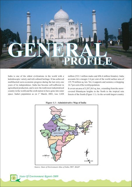
GENERAL India is one <strong>of</strong> the oldest civilizations in the world with a kaleidoscopic variety <strong>and</strong> rich cultural heritage. It has achieved multifaceted socio-economic progress during the last sixty-one yea<strong>rs</strong> <strong>of</strong> its independence. India has become self-sufficient in agricultural production, <strong>and</strong> is now the tenth most industrialized country in the world <strong>and</strong> the sixth nation to have gone into outer st space. India's population as on 1 March, 2001, was 1,028 2 State Of <strong>Environment</strong> Report-2009 PROFILE Figure 1.1 : Administrative Map <strong>of</strong> India Source: State <strong>of</strong> <strong>Environment</strong> Atlas <strong>of</strong> India 2007, MoEF million (532.1 million males <strong>and</strong> 496.4 million females). India accounts for a meagre 2.4 per cent <strong>of</strong> the world surface area <strong>of</strong> 135.79 million sq. km. Yet, it supports <strong>and</strong> sustains a whopping 16.7 per cent <strong>of</strong> the world population. It cove<strong>rs</strong> an area <strong>of</strong> 3,287,263 sq. km., extending from the snowcovered Himalayan heights in the North to the tropical rain forests <strong>of</strong> the South (Figure 1.1). As the seventh largest country
in the world, India st<strong>and</strong>s apart from the rest <strong>of</strong> Asia, marked <strong>of</strong>f as it is by mountains <strong>and</strong> the sea, which give the country a distinct geographical entity. Bounded by the Great Himalaya in the North, it stretches southwards <strong>and</strong> at the Tropic <strong>of</strong> Cancer, tape<strong>rs</strong> <strong>of</strong>f into the Indian Ocean between the Bay <strong>of</strong> Bengal in the East <strong>and</strong> the Arabian Sea in the West. India has a l<strong>and</strong> frontier <strong>of</strong> about 15,200 km. The total length <strong>of</strong> the coastline, including the mainl<strong>and</strong>, Lakshadweep Isl<strong>and</strong>s, <strong>and</strong> the Andaman <strong>and</strong> Nicobar Isl<strong>and</strong>s is 7, 517 km. PHYSIOGRAPHY & RELIEF Countries sharing a common border with India are Afghanistan <strong>and</strong> Pakistan in the North-West, China, Bhutan <strong>and</strong> Nepal in the North <strong>and</strong> Myanmar <strong>and</strong> Bangladesh in the East. Sri Lanka is separated from India by a narrow channel <strong>of</strong> sea formed by the Palk Strait <strong>and</strong> the Gulf <strong>of</strong> Mannar. The mainl<strong>and</strong> comprises <strong>of</strong> four regions, namely, the Great Mountain Zone, the Indo-Gangetic Plains, the Desert Region <strong>and</strong> the Southern Peninsula. Valley <strong>of</strong> flowe<strong>rs</strong> The Himalaya comprises <strong>of</strong> three near parallel ranges inte<strong>rs</strong>pe<strong>rs</strong>ed with large plateaus <strong>and</strong> valleys, some <strong>of</strong> which, like the Kashmir <strong>and</strong> Kullu valleys, are fertile, extensive <strong>and</strong> <strong>of</strong> great scenic beauty. Some <strong>of</strong> the highest peaks in the world are found in these ranges. In the East, between India <strong>and</strong> Myanmar, <strong>and</strong> India <strong>and</strong> Bangladesh, the hill ranges are much lower. The Garo, Khasi, Jaintia <strong>and</strong> Naga hills, running almost East-West, join the chain <strong>of</strong> the Mizo <strong>and</strong> Arakan hills running North-South. The Indo-Gangetic Plains, about 2,400 km long <strong>and</strong> ranging from 240 to 320 km in width, are formed by the basins <strong>of</strong> three distinct river systems - the Indus, the Ganga <strong>and</strong> the Brahmaputra. They are one <strong>of</strong> the world's greatest stretches <strong>of</strong> flat alluvium <strong>and</strong> also one <strong>of</strong> the most densely populated areas on Earth. The Desert Region can be divided into two parts - the great Thar desert <strong>and</strong> the ‘little desert’. The great Thar desert extends from the edge <strong>of</strong> the Rann <strong>of</strong> Kutch beyond the Luni River northwards. The whole <strong>of</strong> Rajasthan-Sind frontier runs through this. The ‘little desert’ extends from the Luni between Jaisalmer <strong>and</strong> Jodhpur up to the Northern West. Between the great Thar desert <strong>and</strong> the little desert, lies a zone <strong>of</strong> absolutely sterile country, consisting <strong>of</strong> rocky l<strong>and</strong> cut by limestone ridges. The Peninsular Plateau is marked <strong>of</strong>f from the plains <strong>of</strong> river Ganga <strong>and</strong> the Indus by a mass <strong>of</strong> mountain <strong>and</strong> hill ranges, varying from 460 to 1,220 mete<strong>rs</strong> in height. Prominent among these are the Aravali, Vindhya, Satpura, Maikala <strong>and</strong> Ajanta. The Peninsula is flanked on one side by the Eastern Ghats with an average elevation <strong>of</strong> about 610 mete<strong>rs</strong>, <strong>and</strong> on the other by the Western Ghats where the average elevation varies between 915 to 1,220 mete<strong>rs</strong>, rising in places to over 2,440 mete<strong>rs</strong>. The southern point <strong>of</strong> the plateau, where the Eastern <strong>and</strong> the Western Ghats meet is formed by the Nilgiri Hills. The Cardamom Hills lying beyond may be regarded as a continuation <strong>of</strong> the Western Ghats. COASTAL AREA India’s coast is 7,517 km (4,671 miles) long; <strong>of</strong> this distance, 5,423 km (3,370 miles) belongs to peninsular India, <strong>and</strong> 2,094 km (1,301 miles) to the Andaman, Nicobar, <strong>and</strong> Lakshadweep Isl<strong>and</strong>s. According to the Indian naval hydrographic charts, the mainl<strong>and</strong> coast consists <strong>of</strong> the following: 43 per cent s<strong>and</strong>y beaches, 11 per cent rocky coast including cliffs, <strong>and</strong> 46 per cent mud flats or ma<strong>rs</strong>hy coast. Notable coastal features <strong>of</strong> India comprise the ma<strong>rs</strong>hy Rann <strong>of</strong> Kutch in the West <strong>and</strong> the alluvial Sundarbans Delta in the East, which India shares with Bangladesh. India has two archipelagos - the Lakshadweep, coral atolls beyond India’s South-Western coast, <strong>and</strong> the Andaman <strong>and</strong> Nicobar Isl<strong>and</strong>s, a volcanic isl<strong>and</strong> chain in the Andaman Sea. RIVERS OF INDIA The rive<strong>rs</strong> <strong>of</strong> India can be classified into four groups viz., the Himalayan rive<strong>rs</strong>, the Deccan rive<strong>rs</strong>, the coastal rive<strong>rs</strong>, <strong>and</strong> rive<strong>rs</strong> <strong>of</strong> the inl<strong>and</strong> drainage basin. The main Himalayan River System includes the Indus <strong>and</strong> the Ganga-Brahmaputra-Meghna system. The Indus originates near Mansarovar in Tibet, flows through India <strong>and</strong> Pakistan, <strong>and</strong> finally falls into the Arabian Sea near Karachi. Its important tributaries flowing through Indian territory are Sutlej (originating in Tibet), Beas, Ravi, Chenab <strong>and</strong> Jhelum. The Ganga-Brahmaputra-Meghna river system creates principal subbasins <strong>of</strong> the Bhagirathi <strong>and</strong> the Alakn<strong>and</strong>a, which join at Dev Prayag to form the Ganga. It then trave<strong>rs</strong>es through Uttarakh<strong>and</strong>, Uttar Pradesh, Bihar, <strong>and</strong> West Bengal. Below the Rajmahal hills, Bhagirathi, which used to be the main cou<strong>rs</strong>e in the past, takes <strong>of</strong>f, while Padma continues eastwards <strong>and</strong> ente<strong>rs</strong> Bangladesh. The Yamuna, Ramganga, Ghaghra, G<strong>and</strong>ak, Kosi, Mahan<strong>and</strong>a <strong>and</strong> Sone are the important tributaries <strong>of</strong> Ganga. Rive<strong>rs</strong> Chambal <strong>and</strong> Betwa are the important sub-tributaries, which join Yamuna before it merges with Ganga. The Padma <strong>and</strong> the Brahmaputra Overview 3
- Page 1 and 2: lR;eso t;rs State of Environment Re
- Page 5: © Ministry of Environment and Fore
- Page 10 and 11: Executive Summary In the global con
- Page 12 and 13: guideline to help planners and mana
- Page 15: CHAPTER - 1 OVERVIEW
- Page 19 and 20: India’s forest cover ranges from
- Page 21: These include increasing importance
- Page 24 and 25: LAND India is the seventh largest c
- Page 26 and 27: The varying degrees and types of de
- Page 28 and 29: The total tree cover of the country
- Page 30 and 31: thematic maps like land capability
- Page 32 and 33: A view of Annamalai forest machine
- Page 34 and 35: AIR In India, air pollution is prov
- Page 36 and 37: Air borne emissions emitted from va
- Page 38 and 39: almost all the locations as per the
- Page 40 and 41: 3 Concentration (µg/m ) 3 Concentr
- Page 42 and 43: 3 Concentration (µg/m ) 3 Concentr
- Page 44 and 45: Sl. No. per cent), pharyngitis (16.
- Page 46 and 47: 2 Sl.No. Cooking fuel Tuberculosis
- Page 48 and 49: Source: Central Pollution Control B
- Page 50 and 51: identified sixteen cities namely; H
- Page 52 and 53: issued for adherence to idling emis
- Page 54 and 55: WATER From the East to the West and
- Page 56 and 57: yields or even total crop failure.
- Page 58 and 59: Source: Ministry of Water Resources
- Page 60 and 61: Wastewater from industrial activiti
- Page 62 and 63: �Socially disadvantaged groups su
- Page 64 and 65: BIODIVERSITY India is one of the 17
- Page 66 and 67:
Buffalo (Bubalus bubalis) in a smal
- Page 68 and 69:
Table 2.4.1: State-wise List of Wet
- Page 70 and 71:
Meghalaya as well as the plain regi
- Page 72 and 73:
2 while open mangrove covers an are
- Page 74 and 75:
infant mortality and are susceptibl
- Page 76 and 77:
iii. Regulation of introduction of
- Page 78 and 79:
network of biosphere reserves has i
- Page 80 and 81:
66 State Of Environment Report-2009
- Page 82 and 83:
Source: Wildlife Institute of India
- Page 84 and 85:
disclosure. The Act mandatorily req
- Page 87 and 88:
CHAPTER - 3 KEY ENVIRONME NTAL ISSU
- Page 89 and 90:
�Extreme rise in maximum and mini
- Page 91 and 92:
Figure 3.1.3: Natural Hazards Affec
- Page 93 and 94:
Forests Preliminary assessments, us
- Page 95 and 96:
drought include incurred demand of
- Page 97 and 98:
Development of Pre-fab modular hous
- Page 99 and 100:
Climate change will lead to an incr
- Page 101 and 102:
�Poverty Poverty has been identif
- Page 103 and 104:
Flood in Bihar bodies in putting in
- Page 105 and 106:
After registering impressive gains
- Page 107 and 108:
low yields of pulses, the main prot
- Page 109 and 110:
Table 3.2.4 : Average Annual Growth
- Page 111 and 112:
There are many factors limiting agr
- Page 113 and 114:
(ii) National Food Security Mission
- Page 115 and 116:
6. Establishment of a water securit
- Page 117 and 118:
Temporal Challenge Almost 80 per ce
- Page 119 and 120:
growing population, there will be g
- Page 121 and 122:
IMPACT Most human activities whethe
- Page 123 and 124:
Figure 3.3.3 : The Concept of the
- Page 125 and 126:
1. Chennai Petroleum Corporation Li
- Page 127 and 128:
for the education and training of p
- Page 129 and 130:
framework for integrated water reso
- Page 131 and 132:
anging from Andhra Pradesh, borderi
- Page 133 and 134:
The Ministry of Petroleum and Natur
- Page 135 and 136:
2. RENEWABLE ENERGY India is blesse
- Page 137 and 138:
d) Geothermal Energy It has been es
- Page 139 and 140:
Source: Annual Report 2007-08, Mini
- Page 141 and 142:
GW (mtoe) 900 800 700 600 500 400 3
- Page 143 and 144:
electricity with the focus on deman
- Page 145 and 146:
Energy Conservation potential in th
- Page 147 and 148:
engaged in the field of oilseed cul
- Page 149 and 150:
Census Years Source : Census of Ind
- Page 151 and 152:
Census Years According to the Censu
- Page 153 and 154:
Opportunities in urban areas for em
- Page 155 and 156:
6) Transport Urban areas in India,
- Page 157 and 158:
Figure 3.5.3: Households with Impro
- Page 159 and 160:
The higher percentages of urban san
- Page 161 and 162:
sources of pollution is to integrat
- Page 163 and 164:
City Lucknow Kolkata Kanpur Mumbai
- Page 165 and 166:
Box 3.5.4: Recycling Waste In Namak
- Page 167 and 168:
No. of Dumpsites Electronic Waste (
- Page 169 and 170:
5. National Urban Transport Policy,
- Page 171:
Sectors under this scheme are: �R
- Page 174 and 175:
Managing natural resources requires
- Page 176 and 177:
of time and is also constantly evol
- Page 178 and 179:
The role and the reach of various m
- Page 180 and 181:
processes, goods and services, faci
- Page 182 and 183:
168 State Of Environment Report-200
- Page 184 and 185:
Table 3.4.3 Type-wise and Category-
- Page 186 and 187:
172 Sensitization/Stakeholders Work
- Page 188 and 189:
15. Mr. Prakash Rao Senior Coordina
- Page 190 and 191:
176 Consultation Workshop on ‘Dra
- Page 192 and 193:
15. Ms. Shipla Chohan Advocate Envi
- Page 194:
Ministry of Environment & Forests P