The Ore Bin - Oregon Department of Geology and Mineral Industries
The Ore Bin - Oregon Department of Geology and Mineral Industries
The Ore Bin - Oregon Department of Geology and Mineral Industries

Create successful ePaper yourself
Turn your PDF publications into a flip-book with our unique Google optimized e-Paper software.
State <strong>of</strong> <strong>Ore</strong>gon<br />
<strong>Department</strong> <strong>of</strong> <strong>Geology</strong><br />
<strong>and</strong> <strong>Mineral</strong> <strong>Industries</strong><br />
1069 State Office Bldg.<br />
Portl<strong>and</strong> <strong>Ore</strong>gon 97201<br />
THE DESCHUTES VALLEY EARTHQUAKE OF APRIL 12, 1976<br />
Richard Couch, Glenn Thrasher, <strong>and</strong> Kenneth Keeling<br />
Geophysics Group<br />
School <strong>of</strong> Oceanography<br />
<strong>Ore</strong>gon Sta te Un i vers ity<br />
Corva 11 is, <strong>Ore</strong>gon 97331<br />
Introduction<br />
<strong>The</strong> ORE BIN<br />
Vol ume 38, No.1 0<br />
October 1976<br />
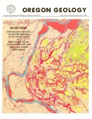
On April 12, 1976 an earthquake <strong>of</strong> magnitude 4.8 occurred northeast<br />
<strong>of</strong> Maupin in northcentral <strong>Ore</strong>gon (Figure 1). <strong>The</strong> earthquake<br />
was felt over an area <strong>of</strong> approximately 81,400 square kilometers<br />
(31,400 mi 2) <strong>and</strong> exhibited the higher surface intensities along<br />
the Deschutes River valley. <strong>The</strong> areas about Tygh Valley, Maupin,<br />
<strong>and</strong> South Junction, <strong>Ore</strong>gon exhibited maximum intensities <strong>of</strong> V to VI.<br />
Summaries <strong>of</strong> historic earthquakes by Townly <strong>and</strong> Allen (1939),<br />
Berg <strong>and</strong> Baker (1963), <strong>and</strong> Couch <strong>and</strong> Lowell (1971) list no previous<br />
earthquakes for the immediate area. Berg <strong>and</strong> Baker (1963)<br />
list the occurrence <strong>of</strong> earthquakes: near Madras in 1942; in the<br />
vicinity <strong>of</strong> the Dalles in 1866, 1892, <strong>and</strong> 1893; near Hood River<br />
in 1902; <strong>and</strong> at Fossil in 1948. Berg <strong>and</strong> Baker (1963) list an<br />
earthquake at Mount Hood in 1896, <strong>and</strong> the umpublished files <strong>of</strong><br />
<strong>Ore</strong>gon State University Seismological Station list an earthquake<br />
at Mount Hood in 1974. <strong>The</strong> historic earthquakes were less intense<br />
than the Deschutes valley earthquake <strong>and</strong> were located more than<br />
40 km (27 mi) from the epicenter <strong>of</strong> the Deschutes valley earthquake.<br />
<strong>The</strong> seismic potential <strong>and</strong> seismic processes <strong>of</strong> the area are<br />
not well understood, but they are relevant to an explanation <strong>of</strong><br />
the contemporary tectonics <strong>of</strong> central <strong>Ore</strong>gon <strong>and</strong> southern Washington;<br />
therefore an extensive investigation <strong>of</strong> this relatively<br />
small earthquake was undertaken.<br />
Earthquake Intensities<br />
Reports obtained by personal interviews with the inhabitants<br />
<strong>of</strong> north-central <strong>Ore</strong>gon on April 14, 15, <strong>and</strong> 16 indicated houses<br />
shook, swayed, rattled, creaked, <strong>and</strong> rocked in the Deschutes valley<br />
during the earthquake. Associated sounds were reported as<br />
rumblings like distant thunder, booms similar to sonic booms, <strong>and</strong><br />
a roaring noise like a strong wind or blasting. At locations<br />
151