Canopies and Corridors - International Fund for Animal Welfare
Canopies and Corridors - International Fund for Animal Welfare
Canopies and Corridors - International Fund for Animal Welfare

You also want an ePaper? Increase the reach of your titles
YUMPU automatically turns print PDFs into web optimized ePapers that Google loves.
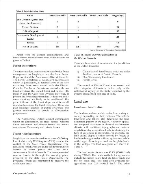
Table 6 Administrative Units<br />
Apart from the district administration <strong>and</strong><br />
headquarters, the functional units of the districts are<br />
given in Table 6.<br />
Forest institutions<br />
Two major modern institutions responsible <strong>for</strong> <strong>for</strong>est<br />
management in Meghalaya are the State Forest<br />
Department <strong>and</strong> the Autonomous District Councils.<br />
The Forest Department of Meghalaya encompasses<br />
within its jurisdiction, all <strong>for</strong>ested areas of the state<br />
excluding those areas vested with the District<br />
Councils. The Forest Department started with two<br />
<strong>for</strong>est divisions, the United Khasi <strong>and</strong> Jaintia Hills<br />
Division <strong>and</strong> the Garo Hills Division. However, at<br />
present the <strong>for</strong>est department has 17 divisions <strong>and</strong> 3<br />
more divisions, are likely to be established. The<br />
present thrust of the <strong>for</strong>est department is on all<br />
round restoration of the <strong>for</strong>est ecosystem. The action<br />
plan envisages creation of public awareness <strong>and</strong><br />
greater involvement of people in af<strong>for</strong>estation<br />
programmes.<br />
The Autonomous District Council encompasses<br />
within its jurisdication, all areas outside National<br />
Parks, Sanctuaries <strong>and</strong> Reserve Forests <strong>and</strong> mainly<br />
comprises of Community <strong>and</strong> private <strong>for</strong>ests.<br />
Forest Administration<br />
Meghalaya has an estimated <strong>for</strong>est area of 9,506 sq.<br />
km, of which only 725.13 sq. km. (7.6%) is under the<br />
control of the State Forest Department. The<br />
remaining <strong>for</strong>est areas are under the direct/indirect<br />
control of Khasi, Jaintia <strong>and</strong> Garo Hills<br />
Autonomous District Councils. The management of<br />
reserve <strong>for</strong>ests is through the working plans<br />
prepared by the State Forest Department. The<br />
protected <strong>for</strong>ests are maintained to preserve the<br />
catchments areas.<br />
<strong>Canopies</strong> <strong>and</strong> <strong>Corridors</strong><br />
Types of Forests under the jurisdiction of<br />
the District Councils<br />
There are three kinds of <strong>for</strong>ests under the jurisdiction<br />
of the District Councils:<br />
i) Old un-classed State Forests, which are under<br />
the direct control of District Councils<br />
ii) Clan/Community <strong>for</strong>ests <strong>and</strong><br />
iii) Private <strong>for</strong>ests<br />
The control of District Councils on second <strong>and</strong><br />
third categories of <strong>for</strong>ests is limited only to the<br />
collection of royalty on the timber exported by the<br />
owners, outside their own area of trade.<br />
L<strong>and</strong> use<br />
L<strong>and</strong> use classification<br />
[Source: Directorate of Economics & Statistics-2002]<br />
The l<strong>and</strong> use <strong>and</strong> ownership varies from society to<br />
society depending on their cultures. The beliefs,<br />
traditions <strong>and</strong> taboos also determine the l<strong>and</strong><br />
utilization pattern in the region. However, spatial<br />
<strong>and</strong> temporal variations in physical environment,<br />
climate, soil conditions, topography <strong>and</strong> natural<br />
vegetation play a significant role in deciding the<br />
type of use a l<strong>and</strong> is put under. For example, the<br />
l<strong>and</strong> on hill slopes is either covered by <strong>for</strong>ests or<br />
has been brought under shifting agriculture, while<br />
settled agriculture is practiced on the plain l<strong>and</strong>s<br />
in the valleys. The l<strong>and</strong> categories are shown in<br />
Table 7.<br />
The l<strong>and</strong> under <strong>for</strong>ests was 42.4% (9500.0 km 2 )<br />
during 1997-99. The l<strong>and</strong>s available <strong>for</strong> agriculture<br />
include the current fallow l<strong>and</strong>, old fallow l<strong>and</strong>s <strong>and</strong><br />
the net sown area. The total area available <strong>for</strong><br />
agriculture was 22% (4944.3 km 2 ). The other<br />
19