Geology of the Van Buren and Lavaca Quadrangles, Arkansas ...
Geology of the Van Buren and Lavaca Quadrangles, Arkansas ...
Geology of the Van Buren and Lavaca Quadrangles, Arkansas ...

You also want an ePaper? Increase the reach of your titles
YUMPU automatically turns print PDFs into web optimized ePapers that Google loves.
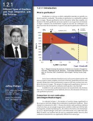
A8 GEOLOGY OF THE ARKANSAS VALLEY COAL FIJCL+PAFtT 2<br />
uppermost part, very fine to medium-grained s<strong>and</strong>stone<br />
<strong>and</strong> quartz s<strong>and</strong>. Some parts <strong>of</strong> <strong>the</strong> Penters are limy;<br />
o<strong>the</strong>r parts are dolomitic. Very light gray limy granular<br />
to very fine crystalline dolomite is present. Some <strong>of</strong> <strong>the</strong><br />
dolomite contains white translucent to milky chert.<br />
Very light gray dolomitic granular to very finely<br />
crystalline limestone containing white to very light<br />
gray translucent to milky dense chert is present.<br />
DEVONIAN AND MISSISSIPPIAN SYSTEMS, CHATTANOOGA<br />
SHALE<br />
The Chattanooga in nor<strong>the</strong>rn <strong>Arkansas</strong> unconform-<br />
ably overlies <strong>the</strong> Penters <strong>and</strong> is unconformably overlain<br />
by <strong>the</strong> Boone Formation. In <strong>the</strong> area <strong>of</strong> this report <strong>the</strong><br />
Chattanooga overlies <strong>the</strong> Penters Chert <strong>and</strong> is over-<br />
lain by <strong>the</strong> Boone Formation or, in those areas where<br />
<strong>the</strong> Boone-type rocks are absent, by <strong>the</strong> Moorefield<br />
Formation.<br />
The Chattanooga is known to range in thickness from<br />
9 to 121 feet in <strong>the</strong> two quadrangles (fig. 4). In <strong>the</strong><br />
<strong>Lavaca</strong> quadrangle, <strong>the</strong> Chattanooga thickens south-<br />
ward by about <strong>the</strong> same amount that <strong>the</strong> overlying<br />
Boone Formation thins; this relationship is less con-<br />
sistent in <strong>the</strong> <strong>Van</strong> <strong>Buren</strong> quadrangle (fig. 4). The<br />
formation is a dark-gray to grayish-black sooty-<br />
appearing shale that contains very finely to coarsely<br />
crystalline pyrite <strong>and</strong>, locally, very thin layers <strong>of</strong><br />
medium-gray silts tone.<br />
MISSISSIPPIAN SYSTEM<br />
The Mississippian System <strong>of</strong> this report comprises, in<br />
ascending order, <strong>the</strong> Boone Formation, Moorefield<br />
Formation, Fayetteville Shale, <strong>and</strong> Pitkin Limestone.<br />
The Mississippian rocks range in thickness from 290 to<br />
604 feet <strong>and</strong> are thickest in <strong>the</strong> central part <strong>of</strong> <strong>the</strong> area<br />
(fig. 5C). The thickness <strong>of</strong> <strong>the</strong> Chattanooga Shale <strong>and</strong><br />
younger Mississippian rocks is shown in figure 5D. In<br />
northwestern <strong>Arkansas</strong> <strong>and</strong> nor<strong>the</strong>astern Oklahoma, <strong>the</strong><br />
Boone is mostly limestone <strong>and</strong> chert; <strong>the</strong> Moorefield is<br />
shale, silty shale, siltstone, limy siltstone, <strong>and</strong> silty<br />
limestone; <strong>the</strong> Fayetteville is mostly nonsilty shale; <strong>and</strong><br />
<strong>the</strong> Pitkin is mostly limestone.<br />
A study <strong>of</strong> thickness maps (figs. 4, 5) shows that <strong>the</strong><br />
Boone <strong>and</strong>, to a lesser extent, <strong>the</strong> Fayetteville Formations<br />
(fig. 4B, 0,) are thin where <strong>the</strong> intervening<br />
Moorefield (fig. 4C) is thick, <strong>and</strong> that <strong>the</strong> combined<br />
thickness <strong>of</strong> <strong>the</strong> three formations (fig. 5B) varies in<br />
proportion to <strong>the</strong> thickness <strong>of</strong> <strong>the</strong> post-Chattanooga<br />
Mississippian rocks (fig. 5C).<br />
The compensating thickening <strong>and</strong> thinning <strong>of</strong> <strong>the</strong><br />
Moorefield in relation to <strong>the</strong> adjacent units can be<br />
explained by <strong>the</strong> following sequence <strong>of</strong> events: (1)<br />
Boone deposition; (2) post-Boone-pre-Moorefield erosion;<br />
(3) Moorefield deposition; (4) post-Moorefield-<br />
pre-Fayetteville erosion; <strong>and</strong> (5) Fayetteville deposi-<br />
tion. Post-Boone-pre-Moorefield erosion would explain<br />
<strong>the</strong> absence <strong>of</strong> limestone <strong>and</strong> chert <strong>of</strong> <strong>the</strong> Boone in many<br />
parts <strong>of</strong> western <strong>Arkansas</strong> <strong>and</strong> eastern Oklahoma, but<br />
itpparently any such erosion did not remove all <strong>the</strong> shale<br />
Df <strong>the</strong> underlying Chattanooga at any place. In <strong>the</strong> area<br />
3f this report <strong>the</strong> Chattanooga is thickest where <strong>the</strong><br />
Boone is thin or absent (fig. 4A, B). In parts <strong>of</strong> nor<strong>the</strong>rn<br />
<strong>Arkansas</strong> <strong>the</strong> Chattanooga is absent, but in <strong>the</strong>se areas<br />
<strong>the</strong> Boone is present.<br />
It seems more logical to <strong>the</strong> authors <strong>of</strong> this report to<br />
account for thickness changes in <strong>the</strong> Moorefield by<br />
relating <strong>the</strong>m to facies changes in <strong>the</strong> Boone from<br />
Limestone <strong>and</strong> chert to silty limestone, limy siltstone,<br />
siltstone, <strong>and</strong> silty shale, <strong>and</strong> in <strong>the</strong> Fayetteville from<br />
nonsilty shale to shale, silty shale, <strong>and</strong> siltstone. Thus<br />
in some areas <strong>of</strong> this report, <strong>the</strong> silty, noncherty rocks<br />
in <strong>the</strong> lowermost part <strong>of</strong> <strong>the</strong> Moorefield we thought to<br />
be equivalent to a part or all <strong>of</strong> <strong>the</strong> cherty rocks <strong>of</strong> <strong>the</strong><br />
Boone in o<strong>the</strong>r areas. Likewise, <strong>the</strong> silty rocks in <strong>the</strong><br />
upper part <strong>of</strong> <strong>the</strong> Moorefield in some areas are thought<br />
to be equivalent to <strong>the</strong> nonsilty shale in <strong>the</strong> lower part<br />
<strong>of</strong> <strong>the</strong> Fayetteville in o<strong>the</strong>r areas.<br />
BOONE FORMATION<br />
In nor<strong>the</strong>rn <strong>Arkansas</strong> <strong>the</strong> Boone Formation uncon-<br />
formably overlies <strong>the</strong> Chattanooga <strong>and</strong> is unconform-<br />
ably overlain by <strong>the</strong> Moorefield Formation. In <strong>the</strong> area<br />
<strong>of</strong> this report <strong>the</strong> Boone unconformably overlies <strong>the</strong><br />
Chattanooga, but it appears to be conformably over-<br />
lain by <strong>the</strong> Moorefield.<br />
The Boone ranges in measured thickness from a<br />
fea<strong>the</strong>redge to 240 feet in <strong>the</strong> area <strong>of</strong> this report. It is<br />
absent in <strong>the</strong> sou<strong>the</strong>rn part <strong>and</strong> is thickest in <strong>the</strong> north-<br />
western, central, <strong>and</strong> nor<strong>the</strong>astern parts (fig. 4B). The<br />
Boone is predominantly white to light-gray translucent<br />
to milky dense to granular chert. Beds <strong>of</strong> light- to<br />
medium-gray dense to finely crystalline limestone <strong>and</strong><br />
cherty limestone are common. Chert is <strong>the</strong> identifying<br />
characteristic <strong>of</strong> <strong>the</strong> Boone Formation. If <strong>the</strong> rocks<br />
directly overlying <strong>the</strong> Chattanooga do not contain<br />
chert, <strong>the</strong>y are identified as Moorefield even though<br />
<strong>the</strong>y may be continuous with <strong>the</strong> Boone in o<strong>the</strong>r<br />
nearby areas.<br />
MOOREFIELD FORMATION<br />
The Moorefield Formation <strong>of</strong> this report overlies <strong>the</strong><br />
Boone or, where cherty Boone-type rocks are absent,<br />
<strong>the</strong> Chattanooga. It ranges in measured thickness from<br />
20 to 344 feet <strong>and</strong> is thickest in <strong>the</strong> south-central <strong>and</strong><br />
north-central parts (fig. 4C). The Moorefield consists <strong>of</strong><br />
dark-gray to grayish-black mostly silty shale, siltstone,<br />
limy siltstone, <strong>and</strong> silty limestone. Lack <strong>of</strong> chert in <strong>the</strong><br />
Moorefield generally differentiates it from <strong>the</strong> Boone.