Geology of the Van Buren and Lavaca Quadrangles, Arkansas ...
Geology of the Van Buren and Lavaca Quadrangles, Arkansas ...
Geology of the Van Buren and Lavaca Quadrangles, Arkansas ...

Create successful ePaper yourself
Turn your PDF publications into a flip-book with our unique Google optimized e-Paper software.
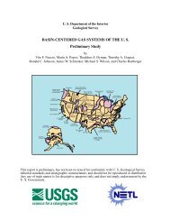
A14 GEOLOGY OF THE ARKANSAS VALLEY COAL FIEL-PART 2<br />
"30' 15' 94'00<br />
\ ' I l'i<br />
*- \\ ( 1 VAN BUREN<br />
. .*. \ \ y$d//QUADF?ANGLE 0 5 10 MILES<br />
4aA+,+j t522 I I<br />
* &<br />
Well producing gas<br />
f<br />
Well with show <strong>of</strong> gas<br />
EXPLANATION<br />
Well being drilled<br />
as <strong>of</strong> Sept. 30,1966<br />
.<br />
Well that did not penetrate <strong>the</strong><br />
mapped unit or that has in-<br />
Well with no + show <strong>of</strong> gas<br />
complete or unavailable<br />
records<br />
LAVACA<br />
QUADRANGLE<br />
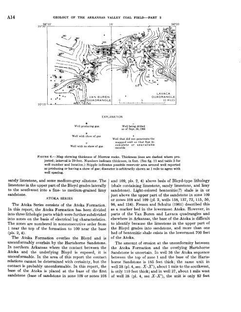
FIQURE 6.-Map showing thickness <strong>of</strong> Morrow rocks. Thickness lines are dashed where projected;<br />
interval is 20 feet. Numbers indicate thickness, in feet. (See fig. 11 <strong>and</strong> table 3 for<br />
well number <strong>and</strong> location.) Stipple indicates possible reservoir area around well reported<br />
as producing or having a show <strong>of</strong> gas; diameter is arbitrarily shown as 1 mile to agree with<br />
well spacing.<br />
s<strong>and</strong>y limestone, <strong>and</strong> some medium-gray siltstone. The<br />
limestone in <strong>the</strong> upper part <strong>of</strong> <strong>the</strong> Bloyd grades laterally<br />
to <strong>the</strong> southwest into a fine- to medium-grained limy<br />
s<strong>and</strong>stone.<br />
ATOKA SERIES<br />
The Atoka Series consists <strong>of</strong> <strong>the</strong> Atoka Formation.<br />
In this report, <strong>the</strong> Atoka Formation has been divided<br />
into three lithologic parts which were fur<strong>the</strong>r subdivided<br />
into zones on <strong>the</strong> basis <strong>of</strong> electrical log characteristics.<br />
The zones are numbered in nonconsecutive order from<br />
1 near <strong>the</strong> top <strong>of</strong> <strong>the</strong> formation to 109 near <strong>the</strong> base<br />
(pls. 2, 4).<br />
The Atoka Formation overlies <strong>the</strong> Bloyd <strong>and</strong> is<br />
unconformably overlain by <strong>the</strong> Hartshorne S<strong>and</strong>stone.<br />
In nor<strong>the</strong>rn <strong>Arkansas</strong> where <strong>the</strong> contact between <strong>the</strong><br />
Atoka <strong>and</strong> <strong>the</strong> underlying Bloyd is exposed, it is<br />
unconformable. In <strong>the</strong> area <strong>of</strong> this report <strong>the</strong> contact<br />
relations cannot be determined with certainty, but <strong>the</strong><br />
contact is probably unconformable. In this report, <strong>the</strong><br />
base <strong>of</strong> <strong>the</strong> Atoka is placed at <strong>the</strong> base <strong>of</strong> <strong>the</strong> first<br />
s<strong>and</strong>stone (base <strong>of</strong> s<strong>and</strong>stone in zone 109 or zones 108<br />
<strong>and</strong> 109, pls. 2, 4) above beds <strong>of</strong> Bloyc-type lithology<br />
(shale containing limestone, s<strong>and</strong>y limestone, <strong>and</strong> limy<br />
s<strong>and</strong>stone). Light-colored bentonitic(?) shale is in or<br />
just above <strong>the</strong> upper part <strong>of</strong> <strong>the</strong> s<strong>and</strong>stone in zone 109<br />
or zones 108 <strong>and</strong> 109 (pl. 2, wells 158, 137, 72, 115, 50,<br />
96, <strong>and</strong> 134). Frezon <strong>and</strong> Schultz (1961) described this<br />
as a marker bed in <strong>the</strong> lowermost Atoka. However, in<br />
parts <strong>of</strong> <strong>the</strong> <strong>Van</strong> <strong>Buren</strong> <strong>and</strong> <strong>Lavaca</strong> quadrangles <strong>and</strong><br />
elsewhere in <strong>Arkansas</strong>, <strong>the</strong> base <strong>of</strong> <strong>the</strong> Atoka is difficult<br />
to identify because <strong>the</strong> limestone in <strong>the</strong> upper part <strong>of</strong><br />
<strong>the</strong> Bloyd grades into s<strong>and</strong>stone, <strong>and</strong> more than one<br />
bed <strong>of</strong> bentonitic shale exists in <strong>the</strong> lowermost 700 feet<br />
<strong>of</strong> <strong>the</strong> Atoka.<br />
The amount <strong>of</strong> erosion at <strong>the</strong> unconformity between<br />
<strong>the</strong> Atoka Formation <strong>and</strong> <strong>the</strong> overlying Hartshorne<br />
S<strong>and</strong>stone is uncertain. In well 36 <strong>the</strong> Atoka sequence<br />
between <strong>the</strong> top <strong>of</strong> zone 1 <strong>and</strong> <strong>the</strong> base <strong>of</strong> <strong>the</strong> Hartshorne<br />
S<strong>and</strong>stone is 185 feet thick; <strong>the</strong> same unit in<br />
well 38 (pl. 4, sec. X-X'), about 1 mile to <strong>the</strong> southwest,<br />
is only 110 feet thick; <strong>and</strong> in well 37, about 1 mile west<br />
<strong>of</strong> well 38 (pl. 4, sec X-X'), <strong>the</strong> unit is only 82 feet