Geology of the Van Buren and Lavaca Quadrangles, Arkansas ...
Geology of the Van Buren and Lavaca Quadrangles, Arkansas ...
Geology of the Van Buren and Lavaca Quadrangles, Arkansas ...

You also want an ePaper? Increase the reach of your titles
YUMPU automatically turns print PDFs into web optimized ePapers that Google loves.
A20<br />
. *'/<br />
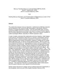
GEOLOGY OF THE ARKANSAS VALLEY COAL FIELD-PART 2<br />
94"30' 15' 94"OO'<br />
VAN BUREN<br />
~<br />
A.ZONE 28<br />
94"30' 15' 94"OO'<br />
QUADRANGLE<br />
YJ f+ -+<br />
B. ZONE 58<br />
LAVACA<br />
QUADRANGLE<br />
0 5 10 MILEI<br />
1 1 1 1 1 1 I<br />
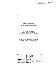
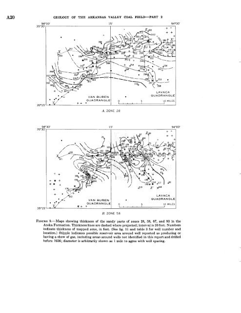
FIGURE<br />
9.-Maps showing thickness <strong>of</strong> <strong>the</strong> s<strong>and</strong>y parts <strong>of</strong> zones 28, 58, 67, <strong>and</strong> 93 in <strong>the</strong><br />
Atoka Formation. Thickness lines are dashed where projected; interval is 20 feet. Numbers<br />
indicate thickness <strong>of</strong> mapped zone, in feet. (See fig. 11 <strong>and</strong> table 3 for well number <strong>and</strong><br />
location.) Stipple indicates possible reservoir area around well reported as producing or<br />
having a show <strong>of</strong> gas, including areas around wells not identified in this report <strong>and</strong> drilled<br />
before 1936; diameter is arbitrarily shown as 1 mile to agree with well spacing.