Geology of the Van Buren and Lavaca Quadrangles, Arkansas ...
Geology of the Van Buren and Lavaca Quadrangles, Arkansas ...
Geology of the Van Buren and Lavaca Quadrangles, Arkansas ...

Create successful ePaper yourself
Turn your PDF publications into a flip-book with our unique Google optimized e-Paper software.
VAN BUREN AND LAVACA QUADRANGLES, ARKANSAS AND OKLAHOMA A15<br />
thick. A complementary thickening <strong>of</strong> <strong>the</strong> Hartshorne<br />
S<strong>and</strong>stone occurs in wells 36 <strong>and</strong> 37; thus post-Atoka<br />
erosion removed as much as 103 feet <strong>of</strong> Atoka in <strong>the</strong><br />
area <strong>of</strong> <strong>the</strong>se wells. Atoka rocks are 223 feet thick above<br />
zone 1 in well 167 (pl. 4, sec. Y-Y’) ; thus, a comparison<br />
between wells 37 <strong>and</strong> 167 suggests that post-Atoka ero-<br />
sion removed as much as 141 feet <strong>of</strong> Atoka rocks. How-<br />
ever, regional thickening <strong>of</strong> <strong>the</strong> rocks above zone l may<br />
account for <strong>the</strong> southward thickening between <strong>the</strong>se<br />
two wells, <strong>and</strong> for as much as 101 feet <strong>of</strong> southward<br />
thickening between wells 37 <strong>and</strong> 143 (pl. 4, sec. Y-Y’).<br />
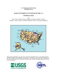
The Atoka is known to range in thickness from 4,375<br />
to 6,755 feet, <strong>and</strong> it may be as much as 8,800 feet thick<br />
in <strong>the</strong> sou<strong>the</strong>astern part <strong>of</strong> <strong>the</strong> report area (fig. 8).<br />
In comparing <strong>the</strong> thickness <strong>of</strong> <strong>the</strong> Atoka (pl. 4; fig. 8)<br />
in relation to <strong>the</strong> structure <strong>of</strong> <strong>the</strong> Hartshorne S<strong>and</strong>stone<br />
(top <strong>of</strong> <strong>the</strong> Atoka) (pl. 5), it is apparent that in most <strong>of</strong><br />
<strong>the</strong> area <strong>the</strong> Atoka is thinner where folded into anticlines<br />
<strong>and</strong> thicker where folded into synclines, <strong>and</strong> that where<br />
<strong>the</strong> Atoka changes thicknesses all parts <strong>of</strong> <strong>the</strong> Atoka<br />
thicken or thin in proportion. Such a relationship sug-<br />
gests that <strong>the</strong> anticlines <strong>and</strong> synclines were developing<br />
during <strong>the</strong> deposition <strong>of</strong> <strong>the</strong> Atoka. It is also possible<br />
to conclude that displacement occurred along many, if<br />
not all, <strong>of</strong> <strong>the</strong> major faults shown on plate 5 during <strong>the</strong><br />
deposition <strong>of</strong> most <strong>of</strong> <strong>the</strong> Atoka. Many <strong>of</strong> <strong>the</strong> major<br />
faults are in <strong>the</strong> area between thick <strong>and</strong> thin Atoka,<br />
<strong>and</strong> <strong>the</strong> thicker part <strong>of</strong> <strong>the</strong> Atoka is on <strong>the</strong> downthrown<br />
side.<br />
In this report, <strong>the</strong> Atoka is arbitrarily divided into<br />
three parts or groups <strong>of</strong> zones as shown in table 1. The<br />
thickness <strong>of</strong> each part is shown in figure 8. If <strong>the</strong> thick-<br />
ness changes reflect tectonic movements during deposi-<br />
tion, <strong>the</strong>n a study <strong>of</strong> <strong>the</strong> thickness maps <strong>of</strong> <strong>the</strong> three<br />
parts <strong>of</strong> <strong>the</strong> Atoka shows that, in most <strong>of</strong> <strong>Van</strong> <strong>Buren</strong><br />
<strong>and</strong> in nor<strong>the</strong>rn <strong>Lavaca</strong> quadrangles, <strong>the</strong> amount <strong>of</strong><br />
flexing was greatest during deposition <strong>of</strong> <strong>the</strong> lower part<br />
<strong>of</strong> <strong>the</strong> Atoka <strong>and</strong> least during deposition <strong>of</strong> <strong>the</strong> upper<br />
part.<br />
The thickness <strong>of</strong> <strong>the</strong> s<strong>and</strong>stone in some <strong>of</strong> <strong>the</strong><br />
numbered zones (figs. 9, 10) seems to have been<br />
influenced by this flexing, particularly in zone 93<br />
(fig. 90). The thickness trends in zone 93 are about<br />
parallel to <strong>the</strong> thickness trends <strong>of</strong> <strong>the</strong> lower part <strong>of</strong><br />
<strong>the</strong> Atoka (fig. 8A). The thickness trends in zones<br />
98, 99, <strong>and</strong> 100 (fig. lOA-C) seem to be parallel to<br />
those in <strong>the</strong> lower part <strong>of</strong> <strong>the</strong> Atoka in some areas,<br />
but <strong>the</strong> thickness trends in zone 101 (fig. 100) are<br />
not parallel in any area. The thickness trends <strong>of</strong> <strong>the</strong><br />
s<strong>and</strong>stone in zones 58 <strong>and</strong> 67 (fig. 9B, 6‘) are somewhat<br />
parallel to those <strong>of</strong> <strong>the</strong> middle part <strong>of</strong> <strong>the</strong> Atoka<br />
(fig. 8B) in a few areas. The thickness trends in zone<br />
28 (fig. 9A) in some areas are parallel to those in <strong>the</strong><br />
upper part <strong>of</strong> <strong>the</strong> Atoka (fig. 80.<br />
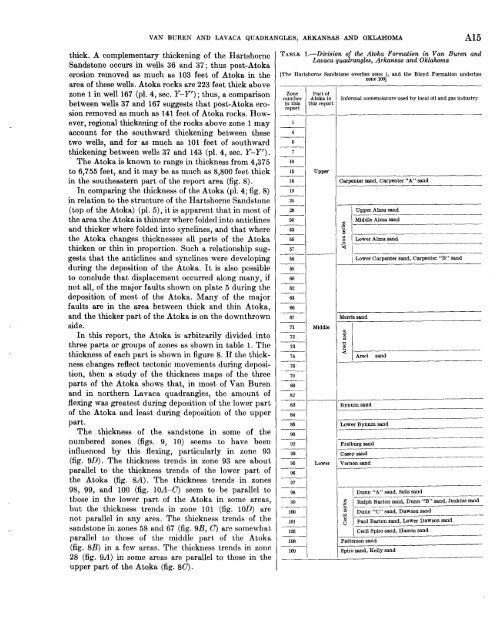
TABLE 1.-Division <strong>of</strong> <strong>the</strong> Atoka Formation in <strong>Van</strong> <strong>Buren</strong> <strong>and</strong><br />
<strong>Lavaca</strong> quadrangles, <strong>Arkansas</strong> <strong>and</strong> Oklahoma<br />
[The Hartshorne S<strong>and</strong>stone overlies zone 1, <strong>and</strong> <strong>the</strong> Bloyd Formation underlies<br />
zone 1091<br />
Zone<br />
number<br />
in this<br />
report<br />
1<br />
Part <strong>of</strong><br />
Atoka in<br />
:his report<br />
4<br />
6<br />
7<br />
10<br />
16 upper<br />
18<br />
____-<br />
19<br />
24<br />
Informal nomenclature used by local oil <strong>and</strong> gas industry<br />
Jarpentar mud, Carpenter “A” s<strong>and</strong><br />
~~<br />
.%<br />
’m<br />
‘ -<br />
5<br />
I Upper Alma s<strong>and</strong><br />
M<br />
67<br />
68<br />
-__<br />
69<br />
60<br />
62<br />
__-<br />
63<br />
1 Lower Carpenter s<strong>and</strong>, Carpenter “B” s<strong>and</strong><br />
66<br />
___ ~<br />
67<br />
Moms s<strong>and</strong><br />
71<br />
72<br />
__-<br />
73<br />
74<br />
78<br />
79 --<br />
80<br />
Middle<br />
82<br />
___<br />
83<br />
84<br />
____<br />
Bynum s<strong>and</strong><br />
______---<br />
--______-__-<br />
__-<br />
____<br />
85<br />
-~<br />
90<br />
Lower Bynum s<strong>and</strong><br />
- _________-____-<br />
92<br />
Freiburg s<strong>and</strong><br />
____ __<br />
93<br />
Casey s<strong>and</strong><br />
96<br />
96<br />
97<br />
Lower Vernon s<strong>and</strong><br />
___<br />
101<br />
106<br />
108<br />
109<br />
Durn “A” s<strong>and</strong>, Sells s<strong>and</strong><br />
Ralph Barton s<strong>and</strong>, Dunn “B” s<strong>and</strong>, Jenkins s<strong>and</strong><br />
Dunn “C” s<strong>and</strong>, Dawson s<strong>and</strong><br />
Paul Barton s<strong>and</strong>, Lower Dawson s<strong>and</strong><br />
_ _ _ _ ~<br />
Cecil Spiro s<strong>and</strong>, Hamm s<strong>and</strong><br />
~ _ _ _ _<br />
p_-_____