MEMORIA: Estudio Impacto Ambiental CN JUCAR - Ministerio de ...
MEMORIA: Estudio Impacto Ambiental CN JUCAR - Ministerio de ...
MEMORIA: Estudio Impacto Ambiental CN JUCAR - Ministerio de ...

You also want an ePaper? Increase the reach of your titles
YUMPU automatically turns print PDFs into web optimized ePapers that Google loves.
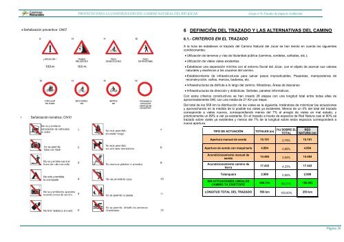
• Señalización preventiva: <strong>CN</strong>07<br />
• Señalización temática: <strong>CN</strong>10<br />
PROYECTO PARA LA CONSTRUCCIÓN DEL CAMINO NATURAL DEL RÍO JÚCAR Anejo nº 8: <strong>Estudio</strong> <strong>de</strong> <strong>Impacto</strong> <strong>Ambiental</strong><br />
6 DEFINICIÓN DEL TRAZADO Y LAS ALTERNATIVAS DEL CAMINO<br />
6.1.- CRITERIOS EN EL TRAZADO<br />
A la hora <strong>de</strong> establecer el trazado <strong>de</strong>l Camino Natural <strong>de</strong>l Júcar se han tenido en cuenta los siguientes<br />
condicionantes:<br />
• Utilización <strong>de</strong> terrenos y vías <strong>de</strong> titularidad pública (caminos, cor<strong>de</strong>les, cañadas, etc.);<br />
• Utilización <strong>de</strong> viales viales existentes.<br />
• Establecer una separación mínima con el entorno fluvial <strong>de</strong>l Júcar, con el objeto <strong>de</strong> acercar sus valores<br />
naturales y escénicos a los usuarios <strong>de</strong>l camino.<br />
• Establecimiento <strong>de</strong> infraestructuras para salvar pasos impracticables. Pasarelas, mamposterías <strong>de</strong><br />
reconstrucción, caños, marcos, ba<strong>de</strong>nes, etc.<br />
• Infraestructuras <strong>de</strong> disfrute a lo largo <strong>de</strong>l camino. Miradores, Áreas <strong>de</strong> <strong>de</strong>scanso<br />
• Infraestructuras <strong>de</strong> dirección y didácticas. Señales, paneles informativos.<br />
Con estos criterios constructivos se han creado 26 etapas con una longitud total entre todas ellas <strong>de</strong><br />
aproximadamente 548, con una media <strong>de</strong> 21 Km por etapa.<br />
Del total <strong>de</strong> los 558 km la distribución <strong>de</strong> los viales es la siguiente, tratándose <strong>de</strong> minimizar las actuaciones<br />
y aprovechando en la medida <strong>de</strong> lo posible los viales ya existentes. Menos <strong>de</strong> un 5% <strong>de</strong>l total <strong>de</strong>l trazado<br />
correspon<strong>de</strong> a viales nuevos, correspondiendo menos <strong>de</strong>l 7% al arreglo <strong>de</strong> viales en mal estado, y<br />
prácticamente un 89% a vial ya existente. En el trazado a través <strong>de</strong> espacios <strong>de</strong> Red Natura casi el 80% es<br />
trazado sobre viales ya existentes y menos <strong>de</strong>l 7% <strong>de</strong> la longitud sobre estos espacios correspon<strong>de</strong>rá a<br />
nueva apertura.<br />
TIPO DE ACTUACIÓN TOTALES (m)<br />
(%) SOBRE EL<br />
TOTAL<br />
RED<br />
NATURA (m)<br />
Apertura manual <strong>de</strong> senda 15.101 2,79% 15.101<br />
Apertura <strong>de</strong> senda con maquinaria 4.894 0,89% 4.894<br />
Acondicionamiento manual <strong>de</strong><br />
senda<br />
Acondicionamiento camino <strong>de</strong><br />
tierra<br />
14.484 2,64% 14.484<br />
17.433 4,23% 17.443<br />
Talanquera 2.999 0,55% 2.999<br />
SIN ACTUACIONES LINEALES<br />
CAMINO YA EXISTENTE<br />
499.214 89,21% 195.093<br />
LONGITUD TOTAL DEL TRAZADO 558 km 100,00% 250 km<br />
Página 30