Plan Estratégico de Desarrollo Regional Concertado Cusco al 2012
Plan Estratégico de Desarrollo Regional Concertado Cusco al 2012
Plan Estratégico de Desarrollo Regional Concertado Cusco al 2012

You also want an ePaper? Increase the reach of your titles
YUMPU automatically turns print PDFs into web optimized ePapers that Google loves.
<strong>Plan</strong> <strong>Estratégico</strong> <strong>de</strong> <strong>Desarrollo</strong> <strong>Region<strong>al</strong></strong> <strong>Concertado</strong> <strong>Cusco</strong> <strong>al</strong> <strong>2012</strong><br />
c. Fragmentación <strong>de</strong> la tierra<br />
La característica princip<strong>al</strong> <strong>de</strong> la agricultura en<br />
la región <strong>Cusco</strong> es la fragmentación <strong>de</strong> la tierra: en<br />
la mayor parte la superficie promedio no <strong>al</strong>canza<br />
ni a las 3 has. En la región <strong>Cusco</strong> el 86.8% <strong>de</strong> los<br />
productores pertenecen <strong>al</strong> minifundio (menos <strong>de</strong> 3<br />
has.) y pequeña agricultura <strong>de</strong> (3 a 9.9 has.).<br />
El 86.8% <strong>de</strong> las Unida<strong>de</strong>s Agropecuarias (menos<br />
<strong>de</strong> 10 has.), poseen el 9.4% <strong>de</strong> las tierras agrícolas;<br />
por otro lado la mediana agricultura <strong>de</strong> 10 a<br />
49.9 has. concentra el 10.3% <strong>de</strong> tierras agrícolas y<br />
el 3.2% <strong>de</strong> productores tiene el 80.3% <strong>de</strong> tierras<br />
agrícolas a nivel region<strong>al</strong>.<br />
Pue<strong>de</strong> afirmarse que tanto en la sierra como<br />
en la selva la mayor superficie <strong>de</strong> tierras<br />
agropecuarias son conducidas por los medianos y<br />
gran<strong>de</strong>s productores. En la sierra los mismos<br />
conducen el 90.8% y en la selva el 89.3% <strong>de</strong> las<br />
respectivas superficies region<strong>al</strong>es (comunida<strong>de</strong>s<br />
campesinas y nativas).<br />
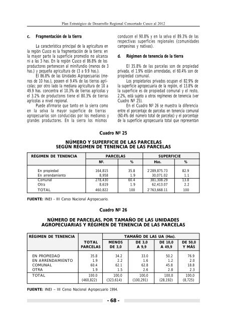
d. Régimen <strong>de</strong> tenencia <strong>de</strong> la tierra<br />
El 35.8% <strong>de</strong> las parcelas son <strong>de</strong> propiedad<br />
privada, el 1.9% están arrendadas, el 60.4% son <strong>de</strong><br />
propiedad comun<strong>al</strong>.<br />
Los propietarios privados ocupan el 82.9% <strong>de</strong><br />
la superficie agropecuaria <strong>de</strong> la región, el 13.8% <strong>de</strong><br />
la superficie es <strong>de</strong> propiedad comun<strong>al</strong> y el resto,<br />
2.2%, está sujeto a otros regímenes <strong>de</strong> tenencia (ver<br />
Cuadro Nº 25).<br />
En el Cuadro Nº 26 se muestra la diferencia<br />
entre el porcentaje <strong>de</strong> parcelas en tenencia comun<strong>al</strong><br />
(60.4% <strong>de</strong>l número tot<strong>al</strong> <strong>de</strong> parcelas) y el porcentaje<br />
<strong>de</strong> la superficie agropecuaria tot<strong>al</strong> que representan<br />
Cuadro Nº 25<br />
NÚMERO Y SUPERFICIE DE LAS PARCELAS<br />
SEGÚN RÉGIMEN DE TENENCIA DE LAS PARCELAS<br />
RÉGIMEN DE TENENCIA PARCELAS SUPERFICIE<br />
Nº. % Has. %<br />
En propiedad 164,815 35.8 2’289,875.73 82.9<br />
En arrendamiento 8,958 1.9 30,071.02 1.1<br />
Comun<strong>al</strong> 278,430 60.4 381,308.29 13.8<br />
Otra 8,619 1.9 62,413.07 2.2<br />
TOTAL 460,822 100 2’763,668.11 100<br />
FUENTE: INEI - III Censo Nacion<strong>al</strong> Agropecuario.<br />
Cuadro Nº 26<br />
NÚMERO DE PARCELAS, POR TAMAÑO DE LAS UNIDADES<br />
AGROPECUARIAS Y RÉGIMEN DE TENENCIA DE LAS PARCELAS<br />
RÉGIMEN DE TENENCIA<br />
TAMAÑO DE LAS UA (Has).<br />
TOTAL MENOS DE 3,0 DE 10,0 DE 50,0<br />
PARCELAS DE 3,0 A 9,9 A 49,9 Y MÁS<br />
EN PROPIEDAD 35.8 34.2 33.0 50.2 76.9<br />
EN ARRENDAMIENTO 1.9 2.2 1.6 1.2 2.0<br />
COMUNAL 60.4 62.1 62.8 45.8 18.8<br />
OTRA 1.9 1.5 2.6 2.8 2.3<br />
TOTAL 100.0 100,0 100,0 100,0 100,0<br />
(460,822) (323,614) (100,291) (28,192) (8,725)<br />
FUENTE: INEI – III Censo Nacion<strong>al</strong> Agropecuario 1994.<br />
- 68 -