pages 162-195 - Réseaux de chercheurs | Télédétection
pages 162-195 - Réseaux de chercheurs | Télédétection
pages 162-195 - Réseaux de chercheurs | Télédétection

Create successful ePaper yourself
Turn your PDF publications into a flip-book with our unique Google optimized e-Paper software.
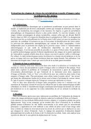
3. Résultats :<br />
L'efficacité <strong>de</strong> cette métho<strong>de</strong> est démontrée par les résultats <strong>de</strong> certaines cartes (Voir Fig.1<br />
et Fig.2) et la comparaison avec une autre métho<strong>de</strong> [4] qui utilise aussi les contours actifs<br />
comme outil <strong>de</strong> base.<br />
Fig1: Première image test: carte digitalisée et le résultat <strong>de</strong> l’extraction du réseau routier<br />
Fig1: Deuxième image test: carte digitalisée et le résultat <strong>de</strong> l’extraction du réseau routier<br />
Mots clés : extraction du réseau routier, contour actif, terme géodésique, mesure <strong>de</strong> Bhattacharyya, Level set.<br />
Bibliographique :<br />
- Chan T. and Vese L., “Active Contours without Edges”, IEEE Transactions on Image Processing, Vol. 10 ,<br />
pp. 266-277, 2001.<br />
- Caselles V., Kimmel R., and Sapiro G., “Geo<strong>de</strong>sic active contours”, International Journal of Computer<br />
Vision, no. 1, pp. 61_79, 1997.<br />
- Freedman D. and T. Zhang. “Active contours for tracking distributions”. IEEE Trans on Image Processing,<br />
13(4): 518-526, 2004.<br />
- Bibo Lu, Yongxia Ku, Hui Wang, “Automatic Road Extraction Method Based on Level Set and Shape<br />
Analysis”, icicta, vol. 3, pp.511-514, 2009.<br />
175