

atlas forestier interactif du congo - World Resources Institute
atlas forestier interactif du congo - World Resources Institute
atlas forestier interactif du congo - World Resources Institute
- No tags were found...

You also want an ePaper? Increase the reach of your titles
YUMPU automatically turns print PDFs into web optimized ePapers that Google loves.
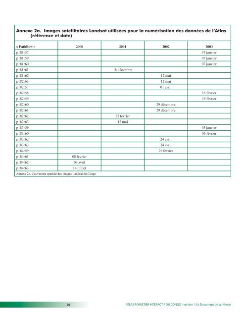
Annexe 2a. Images satellitaires Landsat utilisées pour la numérisation des données de l’Atlas(référence et date)« PathRow » 2000 2001 2002 2003p181r5707 janvierp181r5907 janvierp181r6007 janvierp181r6118 décembrep181r6212 maip182r6312 maip182r5701 avrilp182r5815 févrierp182r5915 févrierp182r6029 décembrep182r6129 décembrep182r6225 févrierp182r6312 maip183r5905 janvierp183r6006 févrierp183r6224 avrilp183r6324 avrilp184r5926 févrierp184r6108 févrierp184r6209 avrilp184r6314 juilletAnnexe 2b. Couverture spatiale des images Landsat <strong>du</strong> Congo26 ATLAS FORESTIER INTERACTIF DU CONGO (version 1.0): Document de synthèse


