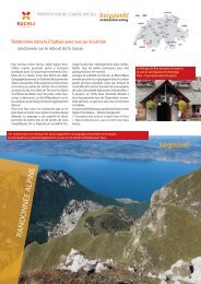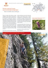
Proposition de Course 08.2021 – Arête ouest du Lauterbrunner Breithorn

Create successful ePaper yourself
Turn your PDF publications into a flip-book with our unique Google optimized e-Paper software.
INFOS EN BREF<br />
<strong>Arête</strong> <strong>ouest</strong> <strong>du</strong> <strong>Lauterbrunner</strong> <strong>Breithorn</strong><br />
Départ / arrivée<br />
Stechelberg 910 m (arrêt <strong>de</strong> car postal : Stechelberg, Hotel)<br />
Accès À VTT ou en transports publics jusqu’à Stechelberg. On peut circuler à VTT jusqu’à Trachsellauenen 1201 m.<br />
À partir <strong>de</strong> là, on continuer à pied. [horaire/prix : www.cff.ch]<br />
Données <strong>de</strong> la course<br />
Description<br />
Exigences / conditions<br />
Matériel / Cartes<br />
Jour 1: montée à la Schmadrihütte (2539 m) : <strong>de</strong>puis Stechelberg 1400 m, 4 h, T2-T3<br />
Jour 2: montée sur le <strong>Lauterbrunner</strong> <strong>Breithorn</strong> (3780 m) par l’arête <strong>ouest</strong> : 1700 m, 7-8 h<br />
Descente au Berghotel Obersteinberg (1778 m) : 2000 m, 4-5 h<br />
Jour 3: <strong>de</strong>scente à Stechelberg (910 m) via Berggasthaus Tschingelhorn : 900 m, 2 h, T2-T3<br />
Montée à la Schmadrihütte : <strong>de</strong> Stechelberg, suivre le chemin <strong>de</strong> randonnée jusqu’à Sichellauenen et Trachsellaunen<br />
(1201 m), aussi possible en VTT. Continuer à pied par Bergwärch, Schwand et Tanzhubel pour<br />
rejoindre la Schmadrihütte (2260 m).<br />
<strong>Lauterbrunner</strong> <strong>Breithorn</strong> <strong>–</strong> arête <strong>ouest</strong> : <strong>de</strong> la cabane, <strong>de</strong>ux possibilités <strong>de</strong> rejoindre le Wätterlickengletscher:<br />
a) Re<strong>de</strong>scendre par le chemin d’accès à la cabane jusqu’au P. 2111 et continuer jusqu’au pont <strong>du</strong> Chrummenbach<br />
P. 2030. Depuis le pont, un chemin monte au Oberhoresee à partir <strong>du</strong>quel on suit une sente direction<br />
SW, qui se perd à proximité <strong>du</strong> P. 2344. Cette variante est plus longue,mais plus confortable.<br />
b) Sinon, <strong>de</strong>scendre brièvement <strong>de</strong>puis la Schmadrihütte jusqu’au glacier rocheux (sente) et rejoindre le<br />
pied <strong>du</strong> Blockgletscher <strong>Breithorn</strong>gletscher. Le traverser en montant légèrement pour s’approcher <strong>du</strong> P. 2344<br />
(petit lac et dalles rocheuses).<br />
Suivre ensuite l’itinéraire indiqué sur la carte jusqu’à la Wätterlicke (3167 m), puis selon le topo par l’arête<br />
<strong>ouest</strong> jusqu’au <strong>Lauterbrunner</strong> <strong>Breithorn</strong>.<br />
Descente au Berghotel Obersteinberg: <strong>de</strong>scendre par l’itinéraire <strong>de</strong> montée jusqu’au chemin con<strong>du</strong>isant à<br />
l’Oberhoresee, puis par le sentier <strong>de</strong> randonnée jusqu’au Berghotel Obersteinberg. Depuis la Wätterlicke,<br />
il est aussi possible <strong>de</strong> <strong>de</strong>scendre en contournant les Tschingelhoren par le S, puis en rejoignant la Mutthornhütte,<br />
et finalement le Gasterental jusqu’à Kan<strong>de</strong>rsteg. On peut aussi suivre le Petersgrat et rejoindre<br />
Lauchernalp en téléphérique.<br />
Randonnée <strong>de</strong> retour à Stechelberg par le Berggasthaus Tschingelhorn : suivre agréablement le sentier <strong>de</strong><br />
randonnée jusqu’à Folla (1677 m, Berggasthaus Tschningelhorn) puis Stechelberg. Si l’on a un VTT à Trachsellauenen<br />
on peut soit le récupérer en passant par Folla ou par Usseri Stäge.<br />
Plus <strong>de</strong> détails et <strong>de</strong> photos dans le livre Hochtouren Topoführer Berner Alpen.<br />
<strong>Course</strong> d’alpinisme assez difficile, AD+, escala<strong>de</strong> 3a (variante 4b), pentes <strong>de</strong> 40°, E3 (engagement).<br />
Passages clé : passages d’escala<strong>de</strong> 3a, rochers/glacier/séracs sur le Wätterlickengletscher et nombreuses<br />
crevasses (courts passages <strong>de</strong> glace rai<strong>de</strong>)<br />
Cor<strong>de</strong> à simple <strong>de</strong> 40 m, sangles, dégaines, 2<strong>–</strong>3 friends utiles, casque, broches à glace, crampons et piolets,<br />
CN 1248 Mürren, Littérature/gui<strong>de</strong>: Hochtouren Topoführer Berner Alpen (4 e édition 2020), Topo.Verlag<br />
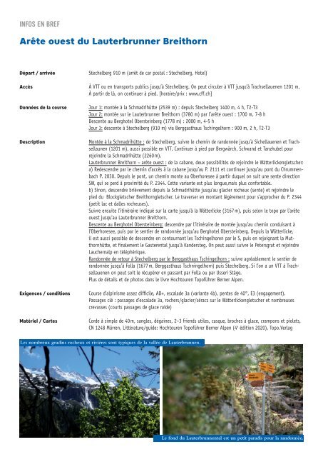
Les nombreux gradins rocheux et rivières sont typiques <strong>de</strong> la vallée <strong>de</strong> Lauterbrunnen.<br />
Le fond <strong>du</strong> Lauterbrunnental est un petit paradis pour la randonnée.