DRUCK_tvb wilder kaiser_wanderfuehrer_soell_taltouren_16

Erfolgreiche ePaper selbst erstellen
Machen Sie aus Ihren PDF Publikationen ein blätterbares Flipbook mit unserer einzigartigen Google optimierten e-Paper Software.
7<br />
energiewegrunde<br />
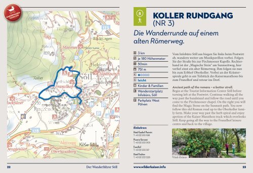
l (NR 52)<br />
Auf zwei Wegen der Sonne entgegen.<br />
! 6,3 km<br />
, je 195 Höhenmeter<br />
` 1h 45min<br />
* 724 m<br />
••<br />
mittelschwierig<br />
F Kinder & Familien<br />
• Wanderstartplatz<br />
Infobüro, Söll<br />
˚ Parkplatz West<br />
Pölven<br />
Ausgangspunkt ist die Freizeitanlage Franzlhof,<br />
von wo aus es zunächst hinunter zum Moorsee geht.<br />
Weiter bis zum Gasthof Oberstegen kommen Sie,<br />
durch eine Unterführung in Stallnähe, direkt zum Weg<br />
entlang der Weißache. Sowohl das Klärwerk als auch<br />
Solarthermiestationen geben Einblicke in die Söller<br />
Energiegewinnung. Bei der Mühlbodenbrücke geht es<br />
rechts ab, vorbei am Hundeauslaufplatz und über den<br />
Ortsteil Gänsleit zurück ins Dorf.<br />
A hike towards the sun – from every direction.<br />
Start at the Franzlhof leisure centre before making<br />
your way to the Moorsee. Now head to the Oberstegen<br />
Gasthof where you go through and underpass next<br />
to the path along the Weißache. Both the sewage treatment<br />
plant – with a biogas plant – and solar thermal<br />
stations provide insights into the energy policy of Söll.<br />
When you come to the Mühlbodenbrücke, turn right<br />
and go past the dog running area, through the Gänsleit<br />
district and back to the village.<br />
Einkehren:<br />
Entlang des Weges finden Sie zahlreiche<br />
Einkehrmöglichkeiten!<br />
Aussichtspunkt am Energieweg<br />
20 Der Wanderführer Söll www.<strong>wilder</strong><strong>kaiser</strong>.info<br />
21