complete agenda - Florida Department of Environmental Protection
complete agenda - Florida Department of Environmental Protection
complete agenda - Florida Department of Environmental Protection

Create successful ePaper yourself
Turn your PDF publications into a flip-book with our unique Google optimized e-Paper software.
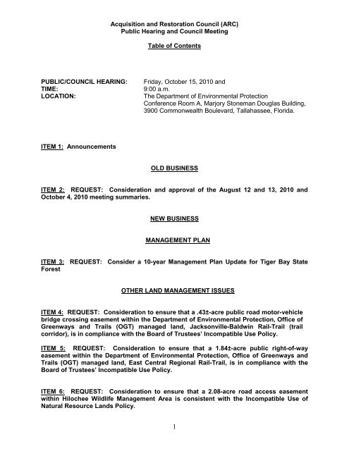
Acquisition and Restoration Council (ARC)<br />
Public Hearing and Council Meeting<br />
Table <strong>of</strong> Contents<br />
PUBLIC/COUNCIL HEARING: Friday, October 15, 2010 and<br />
TIME: 9:00 a.m.<br />
LOCATION: The <strong>Department</strong> <strong>of</strong> <strong>Environmental</strong> <strong>Protection</strong><br />
Conference Room A, Marjory Stoneman Douglas Building,<br />
3900 Commonwealth Boulevard, Tallahassee, <strong>Florida</strong>.<br />
ITEM 1: Announcements<br />
OLD BUSINESS<br />
ITEM 2: REQUEST: Consideration and approval <strong>of</strong> the August 12 and 13, 2010 and<br />
October 4, 2010 meeting summaries.<br />
NEW BUSINESS<br />
MANAGEMENT PLAN<br />
ITEM 3: REQUEST: Consider a 10-year Management Plan Update for Tiger Bay State<br />
Forest<br />
OTHER LAND MANAGEMENT ISSUES<br />
ITEM 4: REQUEST: Consideration to ensure that a .43±-acre public road motor-vehicle<br />
bridge crossing easement within the <strong>Department</strong> <strong>of</strong> <strong>Environmental</strong> <strong>Protection</strong>, Office <strong>of</strong><br />
Greenways and Trails (OGT) managed land, Jacksonville-Baldwin Rail-Trail (trail<br />
corridor), is in compliance with the Board <strong>of</strong> Trustees’ Incompatible Use Policy.<br />
ITEM 5: REQUEST: Consideration to ensure that a 1.84±-acre public right-<strong>of</strong>-way<br />
easement within the <strong>Department</strong> <strong>of</strong> <strong>Environmental</strong> <strong>Protection</strong>, Office <strong>of</strong> Greenways and<br />
Trails (OGT) managed land, East Central Regional Rail-Trail, is in compliance with the<br />
Board <strong>of</strong> Trustees’ Incompatible Use Policy.<br />
ITEM 6: REQUEST: Consideration to ensure that a 2.08-acre road access easement<br />
within Hilochee Wildlife Management Area is consistent with the Incompatible Use <strong>of</strong><br />
Natural Resource Lands Policy.<br />
1
LAND ACQUISITION ISSUES<br />
ITEM 7: REQUEST: Removal <strong>of</strong> ca. 4.85-acre parcel and a 2.22-acre parcel from the<br />
<strong>Florida</strong> Keys Ecosystem <strong>Florida</strong> Forever project boundary.<br />
ITEM 8: REQUEST: Consideration <strong>of</strong> a 994-acre reduction to the Lake Hatchineha<br />
Watershed <strong>Florida</strong> Forever project boundary.<br />
ITEM 9: REQUEST: Consideration <strong>of</strong> a 557-acre reduction to the Osceola Pine Savannas<br />
<strong>Florida</strong> Forever project boundary.<br />
RANKING<br />
ITEM 10: REQUEST: Consideration <strong>of</strong> changes to the Acquisition and Restoration<br />
Council’s procedures for <strong>Florida</strong> Forever project ranking.<br />
DISCUSSION AND INFORMATION ITEMS<br />
ITEM 11: REQUEST: Annual update on status <strong>of</strong> conservation easements.<br />
ITEM 12: REQUEST: Consideration <strong>of</strong> the: (1) Annual Land Management Review Team<br />
findings, (including the last eight reviews not previously provided to the Council) (2)<br />
LMUAC 2010 Annual Report (3) 2010 LMUAC Biennial Land Management Operational<br />
Report<br />
ITEM 13: REQUEST: Presentation <strong>of</strong> information on interagency efforts to develop a<br />
uniform process and guidelines to follow when considering conservation lands for<br />
surplus declaration.<br />
ITEM 14: Management plans for properties 160 acres or smaller, minor amendments to<br />
management plans and emergency items approved since the August, 2010 ARC meeting.<br />
GENERAL ISSUES<br />
ITEM 15: REQUEST: Receive public comment on general land acquisition and<br />
management issues not included on this <strong>agenda</strong>.<br />
2
ITEM 1:<br />
Announcements:
ITEM 2:<br />
1<br />
ARC Summaries<br />
REQUEST: Consideration and approval <strong>of</strong> the August 12 and 13, 2010 and October 4,<br />
2010 meeting summaries.<br />
DSL STAFF REMARKS: None.<br />
DSL STAFF RECOMMENDATION: Approve the August 12 and 13, 2010 and October 4,<br />
2010 meeting summaries.<br />
ARC RECOMMENDATION:<br />
( ) APPROVE<br />
( ) APPROVE WITH<br />
( ) MODIFICATIONS: ___________________________________________________<br />
( ) DEFER<br />
( ) WITHDRAW<br />
( ) NOT APPROVE<br />
( ) OTHER: ___________________________________________________________
Acquisition and Restoration Council (ARC)<br />
Public Hearing<br />
1<br />
ARC Summary August 12, 2010<br />
PUBLIC HEARING: Thursday, August 12, 2010<br />
TIME: 9:00 a.m.<br />
LOCATION: The <strong>Department</strong> <strong>of</strong> <strong>Environmental</strong> <strong>Protection</strong><br />
Conference Room A, Marjory Stoneman Douglas Building,<br />
3900 Commonwealth Boulevard, Tallahassee, <strong>Florida</strong>.<br />
PRESENT: Mr. Scott Stroh, Division <strong>of</strong> Historical Resources (DHR); Ms. Lyssa Ball, Citizen<br />
Member; Mr. John Browne, Division <strong>of</strong> Forestry (DOF); Mr. Gary Cochran, Fish and Wildlife<br />
Conservation Commission (FWC); Dr. Peter Frederick, Citizen Member; Ms. Lynetta Griner,<br />
Citizen Member; Mr. Grant Gelhardt, <strong>Department</strong> <strong>of</strong> Community Affairs (DCA); Mr. Albert<br />
Gregory, <strong>Department</strong> <strong>of</strong> <strong>Environmental</strong> <strong>Protection</strong> (DEP); Mr. Lane Green, Citizen Member and<br />
Vice Chairman<br />
STAFF DIRECTOR:<br />
Mr. Jim Farr, Division <strong>of</strong> State Lands, Office <strong>of</strong> <strong>Environmental</strong> Services<br />
(DSL, OES)<br />
ITEM 1:<br />
Announcements<br />
Mr. Farr announced that Mr. Gregg and Ms. Larson would not be attending the meeting.<br />
Ms. Carolyn Kindell spoke to the members and the audience regarding the effect <strong>of</strong> the funding<br />
cutbacks on <strong>Florida</strong> Natural Areas Inventory (FNAI). She noted that in the FNAI’s core contract<br />
with the DEP, data requests for resource evaluation would be paid by DEP and would be free <strong>of</strong><br />
charge to the requestor. DEP will no longer be able to subsidize data requests, except those<br />
that are statutory requirements. FNAI’s goal is to continue to provide information to the ARC<br />
and those who request information, but they have to be able to cover their costs. They are<br />
temporarily implementing a 32-hour workweek and will be closed on Fridays for the next several<br />
months. Mr. Farr said that with any luck, FNAI will be at full budget next year.<br />
Mr. Farr asks that everyone turn <strong>of</strong>f their cell phones and avoid congregating for discussions at<br />
the reception desk.<br />
ITEM 2:<br />
Consent Agenda (Friday, August 13, 2010 meeting only)<br />
OLD BUSINESS<br />
ITEM 3: REQUEST: Consideration and approval <strong>of</strong> the June 10 and 11, 2010 meeting<br />
summaries.<br />
DISCUSSION: There was no discussion.
ARC Summary August 12, 2010<br />
ARC ACTION: Mr. Cochran moved that this item be placed on the consent <strong>agenda</strong>. The<br />
motion was seconded by Ms. Griner. By a unanimous vote, the motion was approved.<br />
ARC RECOMMENDATION:<br />
(x) APPROVE<br />
( ) APPROVE W/ MODIFICATIONS:<br />
( ) DEFER<br />
( ) WITHDRAW<br />
( ) NOT APPROVE<br />
NEW BUSINESS<br />
LAND ACQUISITION<br />
ITEM 4: REQUEST: Receive public testimony for three proposals (2010 cycle 2) under<br />
consideration for addition to the <strong>Florida</strong> Forever List.<br />
Horse Creek Ranch (HCR)<br />
Dr. Richard Hilsenbeck presented the Horse Creek Ranch proposal. He provided the following<br />
information:<br />
• HCR is 16,000 acres that includes 5 ½ miles <strong>of</strong> Horse Creek and parts <strong>of</strong> Hardee and<br />
Desoto counties.<br />
• This conservation easement is for watershed protection.<br />
• It is owned by Doyle Carlton and is his “home place.”<br />
• 53 percent <strong>of</strong> the property is in natural condition 47 percent is in improved pasture, since<br />
this is an active cattle ranch.<br />
• The property is located on a hydrological divide and it ranges in height from 40-feet to<br />
85-feet above sea level in places.<br />
• After Hurricane Charlie, DOF left snags for wildlife in their cleanup.<br />
• There is a seasonally inundated floodplain forest on the property, as well as a 1933<br />
bridge across the creek.<br />
HCR DISCUSSION: Dr. Frederick asked what the owner’s thoughts on the conservation<br />
easement were. What would he be keeping? What would the state be buying? Dr. Hilsenbeck<br />
said that they would be relinquishing mining and development rights and maintaining grazing,<br />
hunting, and fishing rights. There was a lodge on the property already and he might want to<br />
retain a couple <strong>of</strong> home sites for his children; that was not certain yet. Dr. Hilsenbeck also said<br />
that there was a possibility <strong>of</strong> specialty hunts.<br />
Mr. Cochran mentioned that the Wetlands Reserve Program (WRP) could be a possible partner<br />
for this land, but Dr. Hilsenbeck said it would score quite low on the WRP. There was<br />
discussion that Southwest <strong>Florida</strong> Water Management District could be a partner in the future,<br />
perhaps.<br />
Dr. Hilsenbeck said he has been telling the landowners that it will take about three years before<br />
anything could possibly happen with <strong>Florida</strong> Forever proposals.<br />
Lower Suwannee River and Gulf Watershed Conservation Easement (LSRGW)<br />
2
ARC Summary August 12, 2010<br />
Ms. Lauren Day presented the Lower Suwannee River and Gulf Watershed Conservation<br />
Easement. She provided the following information:<br />
• This is a proposal for a 46,500 acre conservation easement.<br />
• The property is a working forest landscape.<br />
• The proposal area shares 30 miles <strong>of</strong> boundary with other public conservation lands.<br />
• The property is mostly hydric hammock and pine plantation.<br />
• It is hydrologically significant. Its western portion drains to the Gulf and its eastern<br />
portion drains to the Suwannee River.<br />
• It is a critical linkage for the <strong>Florida</strong> Ecological Greenway, providing for wide-ranging<br />
species like the <strong>Florida</strong> Black Bear.<br />
• The owners would relinquish timber rights, residential/commercial, and mining rights as<br />
was done on the California Swamp conservation easement that lies adjacent to it. There<br />
will be no harvesting within forested wetlands.<br />
OTHER SPEAKERS FOR LSRGW<br />
Mr. Charlie Houder, Suwannee River Water Management District (SRWMD) Assistant Executive<br />
Director, noted that he comes before ARC very rarely to support proposals. This one was worth<br />
it, to his way <strong>of</strong> thinking, and they had co-sponsored it. It also included a 10-acre piece on<br />
SRWMD’s California Swamp conservation easement that provides for access to California Lake.<br />
Mr. Houder also commented that the Board <strong>of</strong> Directors did not enter into these sorts <strong>of</strong><br />
partnerships lightly, and that their focus was usually on water quantity. In this case, they<br />
wanted to also provide for coastal protection. SRWMD would be willing to manage the<br />
conservation easement and manage the fee area over at California Lake, maybe even hiring a<br />
contractor to maintain it. There may be a possibility <strong>of</strong> more involvement “down the road”.<br />
Mr. Glen Osteen has been the land manager for this area since 1978. Dixie County is excited<br />
about this conservation easement. Their experience with the California Swamp conservation<br />
easement with the district counterbalanced their suspicions because it has worked so well,<br />
keeping this timber-oriented community working and still keeping properties on the tax rolls.<br />
Mr. George Willson, The Conservation Fund, spoke about the value the conservation<br />
easements have provided the community allowing the area to retain its timber-relevant focus,<br />
and possibly bring timber-related business to the area, since it will be certain that there will be<br />
harvestable forest there for many years.<br />
DISCUSSION FOR LSRGW: Dr. Frederick asked if the easement would protect the hydrology<br />
<strong>of</strong> the system. Mr. Houder said it absolutely would, as all <strong>of</strong> the WMD conservation easements<br />
do. In some cases, the hydrology is restored. If there are specific concerns, in negotiations the<br />
easement can be structured to address those concerns. Mr. Farr added that all DSL easements<br />
require that the hydrology <strong>of</strong> the easement area be protected.<br />
Watermen St. Johns (WSJ)<br />
Mr. Eddy Garcia, applicant, presented the proposal for Watermen St. Johns. He provided the<br />
ARC members with a bound package <strong>of</strong> information, including location, proximity, zonings<br />
according to future land use maps,<br />
• The area within the boundaries is Residential and Mixed Use, and is the centerpoint for<br />
97 sections <strong>of</strong> rural silviculture land.<br />
• A portion <strong>of</strong> the Old Kings Road, in use centuries ago, is located on the property. Built in<br />
1767, it is <strong>Florida</strong>’s Oldest Route, though it most likely existed as paths from one Indian<br />
village to another.<br />
3
ARC Summary August 12, 2010<br />
• The proposal area receives four to eight inches <strong>of</strong> rain per-year, which goes to recharge<br />
the Floridian Aquifer. Considered to be moderate to high recharge.<br />
• Deep Creek, Pelicer Creek, Matanzas, and<br />
• <strong>Florida</strong> Wildlife Federation (FWF) wrote that the site falls in a primary and secondary<br />
bear range for the <strong>Florida</strong> Black Bear St. Johns population.<br />
• Site is part <strong>of</strong> greenways and blueways trail map being considered for the region.<br />
• Their application for development approval includes paved and unpaved trails.<br />
• There are three owners who are not in agreement with the proposal and who do not<br />
want their property within the boundary. Mr. Garcia noted those on the map.<br />
• St. Johns county has more than 30,000 sites (units) approved for development.<br />
• Watermen would be a catalyst for other developments in the south side <strong>of</strong> the county,<br />
which is primarily undeveloped at this time.<br />
• St. John’s County Commission has approved this site being placed in public ownership.<br />
• Acquisition would insure the preservation <strong>of</strong> southern St. Johns County for Floridians.<br />
Mr. Jim Muller, Muller and Associates, spoke, encouraging ARC to vote it forward for further<br />
evaluation. The development is in the Matanzas Basin, which is being considered for possible<br />
Outstanding <strong>Florida</strong> Water (OFW) Designation.<br />
DISCUSSION FOR WSJ: There was no discussion.<br />
ITEM 5: REQUEST: Vote to select acquisition proposals that will proceed through the<br />
2010 cycle project evaluation process for potential addition to the <strong>Florida</strong> Forever priority<br />
list. (Friday, August 13, 2010 meeting only)<br />
ITEM 6: REQUEST: Consideration <strong>of</strong> a 233-acre reduction to the Archie Carr Sea Turtle<br />
Refuge <strong>Florida</strong> Forever project boundary.<br />
DISCUSSION: Mr. Farr briefly explained the item.<br />
ARC ACTION: Mr. Gelhardt moved that this item be placed on the consent <strong>agenda</strong>. The<br />
motion was seconded by Mr. Browne. By a unanimous vote the motion was approved.<br />
ITEM 7: REQUEST: Consideration <strong>of</strong> a 348-acre reduction to the Belle Meade <strong>Florida</strong><br />
Forever project boundary.<br />
DISCUSSION: Mr. Farr briefly explained the item.<br />
ARC ACTION: Mr. Browne moved that this item be placed on the consent <strong>agenda</strong>. The<br />
motion was seconded by Mr. Gelhardt. By a unanimous vote the motion was approved.<br />
ITEM 8: REQUEST: Consideration <strong>of</strong> a 3,612-acre reduction to the Longleaf Pine<br />
Ecosystem <strong>Florida</strong> Forever project boundary.<br />
DISCUSSION: Mr. Farr briefly explained the item.<br />
ARC ACTION: Mr. Browne moved that this item be approved as presented to be placed<br />
on the consent <strong>agenda</strong>. The motion was seconded by Mr. Frederick. By a unanimous<br />
vote the motion was approved.<br />
4
5<br />
ARC Summary August 12, 2010<br />
ITEM 9: REQUEST: Consideration <strong>of</strong> a 251-acre reduction to the Terra Ceia <strong>Florida</strong><br />
Forever project boundary.<br />
DISCUSSION: Mr. Farr briefly explained the item.<br />
ARC ACTION: Mr. Cochran moved that this item be placed on the consent <strong>agenda</strong>. The<br />
motion was seconded by Ms. Griner. By a unanimous vote the motion was approved.<br />
ITEM 10: REQUEST: Consideration <strong>of</strong> a 3,161-acre reduction to the Watermelon Pond<br />
<strong>Florida</strong> Forever project boundary.<br />
DISCUSSION: Mr. Farr briefly explained the item.<br />
ARC ACTION: Mr. Cochran moved that this item be approved as presented to be placed<br />
on the consent <strong>agenda</strong>. The motion was seconded by Mr. Frederick. By a unanimous<br />
vote the motion was approved for the consent <strong>agenda</strong>.<br />
DISCUSSION AFTER ITEM 10 RELATED TO ALL ACREAGE REDUCTION ITEMS: Mr.<br />
Green said this exercise proves there is great popularity for the reduction <strong>of</strong> acreage on<br />
projects. Mr. Cochran commented on the fine work staff are doing with the background and<br />
analysis, as well as working with the managing agencies, FNAI, and other partners. Mr. Browne<br />
echoed the same, adding that every one <strong>of</strong> these parcels had been aired extensively.<br />
WORK PLAN PREPARATION<br />
ITEM 11: REQUEST: Adoption <strong>of</strong> the FY 2010-2011 Division <strong>of</strong> State Lands Annual<br />
<strong>Florida</strong> Forever Work Plan for presentation to the Board <strong>of</strong> Trustees <strong>of</strong> the Internal<br />
Improvement Trust Fund.<br />
DISCUSSION: Dr. Brock presented the workplan. This one is “somewhat tied to the ranking in<br />
June.” “Somewhat” is the term used, because there are some good cause continuations from<br />
current negotiations. The projects on the workplan are greater than the funding available. This<br />
workplan contains $137.9 million in value and another $43 million that DSL actually has<br />
contracts on and hopes to close. He showed ARC the priority list divided into the five<br />
categories, where he had highlighted those that were included in the proposed workplan. There<br />
were a few projects under negotiation that have federal funding available or pending court<br />
actions that did not rank highly in the June list that DSL will continue and proceed with<br />
acquisition.<br />
Mr. Green commented that it would have been helpful if the projects being continued were<br />
somehow identified on the table ARC received in the backup material for the meeting. He also<br />
thought it was important to make sure the public understood how this worked, because there<br />
was an expectation that the workplan would be a reflection <strong>of</strong> the new ranking system.<br />
Mr. Gelhardt commented that this was a very good process. He said that it was transparent,<br />
and was what so many had been looking for, for a long time. He thanked Dr. Brock for his<br />
additional explanation, which made it even clearer.
ARC Summary August 12, 2010<br />
Dr. Hilsenbeck, TNC, complimented DSL on the workplan, and also reported that the BJ Bar<br />
Ranch (on the less-than-fee list) had been purchased with Federal and water management<br />
district funding, so it could removed from the list.<br />
Mr. Stroh said he appreciated all the work, but as the “new guy”, it would be helpful to have a<br />
more thorough understanding <strong>of</strong> the carryover projects. Mr. Green said that he would like to<br />
see whatever DSL provides to Mr. Stroh. Ms. Poppell, Director, DSL, said she would be glad to<br />
meet with him, but she wanted to address his concerns, and <strong>of</strong>fered the following explanation <strong>of</strong><br />
when negotiations would continue in spite <strong>of</strong> a lower ARC ranking:<br />
- Appraisals had been ordered and <strong>of</strong>fers had been made for some lands that DSL need to<br />
follow through on, despite the new categorization and ranking process.<br />
- Some funds have to be held out for eminent domain legal proceedings (fees, interest, judicial<br />
decisions on amount).<br />
Ms. Ball thanked them for the work on this, but asked why there were no projects in the<br />
Substantially Complete category. Also she asked how the $2 million in emergency<br />
archaeological funds could be used. Ms. Poppell said that the emergency funds can only be<br />
used consistently with the criteria outlined in statute; e.g. Imminent threat <strong>of</strong> development. Mr.<br />
Stroh said that they supported the acquisition <strong>of</strong> the Windover Site, and that he had thought<br />
that, based on the ranking, it would be pursued. However, with the carryover, it would not be.<br />
They were being asked about the use <strong>of</strong> the emergency funds now because <strong>of</strong> this. Mr. Green<br />
asked if the emergency funds would be adequate to cover the cost <strong>of</strong> acquisition and Dr. Brock<br />
said they would. As for the Substantially Complete, there are no projects in that category<br />
because those projects have all been taken care <strong>of</strong> and removed from the list.<br />
Dr. Frederick echoed the support for acquiring Windover as soon as possible. Dr. Frederick<br />
said that in each case <strong>of</strong> the carryover projects, it seemed to him that each would be a case by<br />
case situation. He thought that these sorts <strong>of</strong> situations would continue, especially if ARC was<br />
ranking every six months. The ARC has to understand that there is no way to keep up. He<br />
asked for a white paper that addressed what warranted carryover in a project list. Dr. Brock<br />
said that this was called “good faith” and there was a policy paper written on that in the 80’s that<br />
they could resurrect and expand upon for ARC. That policy still applies. Dr. Brock also noted<br />
that, if acquisitions <strong>of</strong> properties within a project are certain to have a partner to share the cost<br />
<strong>of</strong> acquisition, that property might be pursued even if it was not on the list. The rule ARC<br />
worked with and approved does allow DSL flexibility, though a rationale would be needed.<br />
Mr. Green said that the ARC did not have information about these carryover projects when they<br />
were deciding on their ranking. He wondered if knowing about them would have affected his<br />
ranking decisions. Dr. Brock said that it has been done both ways. For some <strong>of</strong> the ARC<br />
members in previous rankings, knowing a project was a carryover made them place it more<br />
toward the top <strong>of</strong> the list. For others, knowing that it was certain to be carried over resulted in<br />
them placing a project more toward the bottom <strong>of</strong> the list.<br />
Dr. Frederick made the motion to adopt the workplan and place that action on the consent<br />
<strong>agenda</strong>. The motion was seconded by Mr. Gelhardt and unanimously approved.<br />
ARC ACTION: Dr. Frederick moved that this item be placed on the consent. The motion<br />
was seconded by Mr. Gelhardt. By a unanimous vote the motion was approved.<br />
CAPITAL IMPROVEMENT WORKPLAN<br />
6
ARC Summary August 12, 2010<br />
ITEM 12: REQUEST: Adopt Workplan for <strong>Florida</strong> Forever Capital Improvement Projects<br />
for FY 10-11<br />
DISCUSSION: Ms. Marianne Gengenbach, DSL, explained the capital improvement project list.<br />
Using a consensus-based ranking process, these projects were prioritized for the FY 08-09<br />
fiscal year. Of the projects that did receive funding, some were not able to be funded in their<br />
entirety. This year, because the funding <strong>of</strong> the <strong>Florida</strong> Forever program was minimal and<br />
yielded only $525,000 for these projects, the decision among the managing agencies was to<br />
continue funding the existing priority list rather than going through another cycle <strong>of</strong> submitting<br />
projects. This provided for completing the funding <strong>of</strong> two projects that were previously only<br />
partially funded and added funding to the next project on the priority list. Werner Boyce State<br />
Park will be able to finish its picnic parking area as well as begin its canoe launch, and more<br />
funding will be provided toward the completion <strong>of</strong> a Point Washington State Forest road project.<br />
ARC ACTION: Mr. Cochran moved that this item be placed on the consent <strong>agenda</strong>. The<br />
motion was seconded by Mr. Gregory. By a unanimous vote the motion was approved.<br />
ARC RECOMMENDATION:<br />
(X) APPROVE<br />
( ) APPROVE W/ MODIFICATIONS:<br />
( ) DEFER<br />
( ) WITHDRAW<br />
( ) NOT APPROVE<br />
EASEMENT LESS-THAN-FORTY ACRES<br />
ITEM 13: REQUEST: Determination <strong>of</strong> whether or not a 34.36-acre conservation<br />
easement in Polk County over property belonging to William and Nancy Bissett fulfills a<br />
clearly delineated state conservation policy and yields a significant public benefit.<br />
DISCUSSION: Jim Farr introduced the item and explained that, unlike previous easements<br />
submitted to ARC for determinations related to property tax exemptions; this easement was not<br />
a regulatory easement. The easement was granted voluntarily to the Green Horizon Land<br />
Trust. One <strong>of</strong> the owners <strong>of</strong> the property, Nancy Bissett, is a botanist who has identified many<br />
listed plant species on the property, and her husband, William Bissett, is a landscape architect.<br />
Mr. Farr explained that staff recommended that the easement both fulfills a clearly delineated<br />
state conservation policy and yields a significant public benefit because <strong>of</strong> the presence <strong>of</strong> land<br />
management for listed plant species on the property.<br />
There was no discussion by the Council members.<br />
ARC ACTION: Mr. Gary Cochran moved staff recommendation that the easement fulfills<br />
a clearly delineated state conservation policy and yields a significant public benefit. The<br />
motion was seconded by Dr. Peter Frederick. The item was voted to the consent <strong>agenda</strong><br />
by a unanimous vote.<br />
ARC DETERMINATION:<br />
Fulfills a clearly delineated state conservation policy:<br />
( x ) Yes ( ) No<br />
Yields a significant public benefit:<br />
7
( x ) Yes ( ) No<br />
ITEM 14:<br />
Forest<br />
MANAGEMENT PLANS<br />
8<br />
ARC Summary August 12, 2010<br />
REQUEST: Consider a 10-year Management Plan for Little Big Econ State<br />
DISCUSSION:<br />
Mr. John Barrow, representing the DOF, presented the plan and stated that 25 miles <strong>of</strong><br />
equestrian trails had been added to the tract.<br />
Mr. Browne stated that some confusion had arisen among the user groups early in the planning<br />
process regarding when their input into trail design and access was appropriate. He stated that<br />
there are many user groups including hikers, bicyclists, and equestrians whose needs must be<br />
balanced with cattle grazing, hunting and endangered species concerns.<br />
Mr. Gelhardt recommended that the map that was presented at the meeting, showing the<br />
proximity <strong>of</strong> the Charles Bronson State Forest to this site, be included in the management plan<br />
to provide a more comprehensive view <strong>of</strong> equestrian resources available. Mr. Barrow stated<br />
that it would be included in the final plan.<br />
Dr. Frederick asked about the additional points <strong>of</strong> access to the Yarborough tract that had been<br />
requested by the equestrian groups. Mr. Browne stated that there are two or three other access<br />
points that are currently being discussed along with additional long and loop trails.<br />
Mr. Green asked if the user groups are happy with this plan. Mr. Browne stated that objections<br />
had calmed and that much <strong>of</strong> the initial objection had resulted from DOF perhaps not explaining<br />
the process adequately to the user groups early in the planning process.<br />
Mr. Robert Christianson, representing the St. Johns River Water Management District<br />
(SJRWMD), complimented the DOF for their wonderful accomplishment, integrating the newly<br />
acquired 20,000 acres into the existing 5,000-acre managed area over the last three years.<br />
ARC ACTION: Mr. Gregory moved that this item be placed on the consent <strong>agenda</strong> as<br />
modified (A map will be added to the final plan that shows the proximity <strong>of</strong> the Charles<br />
Bronson State Forest and other supplemental information will be added to reflect the<br />
changes <strong>of</strong>fered to reach understanding and agreement with recreational users.) The<br />
motion was seconded by Ms. Ball. By a unanimous vote the motion was approved.<br />
ITEM 15: REQUEST: Consider a 10-year Management Plan for Twelve Mile Swamp<br />
Conservation Area<br />
DISCUSSION:<br />
Mr. Robert Christianson, representing the SJRWMD, stated that the BJ Bar ranch had been<br />
successfully acquired under a conservation easement and should be removed from the <strong>Florida</strong><br />
Forever acquisition list. He then presented the Twelve Mile Swamp management plan. He<br />
explained the acquisition history, status <strong>of</strong> existing leases on the property, and revenue derived<br />
from the lease on the property. He said he would work closely with the lessee on management<br />
<strong>of</strong> the site until 2012, when the DOF will assume management <strong>of</strong> this area.
ARC Summary August 12, 2010<br />
Dr. Frederick asked if the lessee was doing any active management on the wet parts <strong>of</strong> this<br />
conservation area. Mr. Christianson stated that the lessee was not.<br />
ARC ACTION: Ms. Ball moved that this item be placed on the consent <strong>agenda</strong>. The<br />
motion was seconded by Dr. Frederick. By a unanimous vote the motion was approved.<br />
OTHER MANAGEMENT ISSUES<br />
ITEM 16: REQUEST: Consideration to ensure that a 3.23-acre stormwater drainage and<br />
maintenance access easement to Brevard County within the Helen and Allan<br />
Cruickshank Sanctuary is in compliance with the Board <strong>of</strong> Trustees’ Incompatible Use<br />
<strong>of</strong> Natural Resource Lands Policy.<br />
DISCUSSION:<br />
Mr. Farr gave a brief summary <strong>of</strong> Item 16, as follows: Consideration to ensure that a 3.23-acre<br />
stormwater and maintenance access easement to Brevard County is in compliance with the<br />
Board <strong>of</strong> Trustees’ ICU Policy. This easement is within the Cruickshank Sanctuary which is<br />
being managed by Brevard County. Barnes Boulevard is being expanded from two to four lanes<br />
and the easement is needed for the project’s stormwater drainage. The easement contains<br />
three parcels (1) an inflow ditch from Barnes Boulevard to the East Pond retention area; (2)<br />
expansion <strong>of</strong> an existing drainage area; and (3) maintenance access along the north and west<br />
boundaries <strong>of</strong> the Sanctuary. The requested easement is to expand an already-existing ditch.<br />
The net positive benefits include a Release <strong>of</strong> Blanket Easement from Brevard County. When<br />
Brevard County deeded the property to the Board <strong>of</strong> Trustees, a blanket easement for access<br />
and maintenance was retained over a majority <strong>of</strong> the Sanctuary property. Now, the County is<br />
releasing the blanket easement from the Board <strong>of</strong> Trustees’ property. Also, over $41,000 is<br />
being reimbursed to the County’s EEL Program for construction <strong>of</strong> a trailhead including parking<br />
and boundary fencing.<br />
Mr. Farr introduced Mr. Joe Mayer, Project Engineer, Bussen-Mayer Engineering, for further<br />
discussion on the specifics <strong>of</strong> the project. Mr. Mayer discussed several overhead slides<br />
depicting the project and the proposed easement. Also, Mr. Mike Knight with Brevard County’s<br />
EEL Program spoke in support <strong>of</strong> the project.<br />
Mr. Cochran, FWC, wanted to clarify that the FWC did not make an <strong>of</strong>ficial determination that<br />
the proposed project would not impact any protected or endangered species as stated in the<br />
item.<br />
Mr. Mayer responded that the permitting phase <strong>of</strong> the project for the water management district<br />
permit involved FWC and USFWS review and approvals <strong>of</strong> the project, and the statement was<br />
intended to reflect these reviews. Mr. Cochran discussed that while permit reviews <strong>of</strong> projects<br />
were important, specific review <strong>of</strong> the easement was required by FWC. Dr. Frederick asked if<br />
Mr. Cochran wanted to defer the item, and Mr. Cochran responded that the net positive benefits<br />
were certainly sufficient for the project, and he felt no deferral was necessary.<br />
Mr. Cochran also asked how the lands were acquired. Mr. Knight responded they were<br />
acquired as a Bargain-Shared Project between Brevard County and the Board <strong>of</strong> Trustees,<br />
where Brevard County purchased the property and then sold it to the Board <strong>of</strong> Trustees with the<br />
County managing the property.<br />
9
ARC Summary August 12, 2010<br />
Mr. Gregory motioned for approval, and Dr. Frederick wanted it in the record that the project<br />
was being approved without receipt <strong>of</strong> FWC and USFWS approvals as stated in the item. Mr.<br />
Green questioned whether the motion was for approval to the consent <strong>agenda</strong>, and Mr. Gregory<br />
responded yes. Mr. Gelhardt seconded the motion and item approved unanimously to be<br />
placed on the consent <strong>agenda</strong>.<br />
ARC ACTION: Mr. Gregory moved that this item be placed on the consent <strong>agenda</strong> for<br />
approval. Mr. Gelhardt seconded the motion. By a unanimous vote the motion was<br />
approved.<br />
ITEM 17: REQUEST: Consideration <strong>of</strong> (1) a determination in accordance with Article X,<br />
Section 18, <strong>Florida</strong> Constitution and Section 253.034(6), <strong>Florida</strong> Statutes, that a 0.22acre<br />
parcel <strong>of</strong> state-owned property that is part <strong>of</strong> the St. Augustine Historical District<br />
and is currently under the management <strong>of</strong> the University <strong>of</strong> <strong>Florida</strong> is no longer needed<br />
for conservation/historical purposes and (2) a determination in accordance with Rule<br />
18-2.018(3)(b)1.c., F.A.C., that the Board <strong>of</strong> Trustees <strong>of</strong> the Internal Improvement Trust<br />
Fund <strong>of</strong> the State <strong>of</strong> <strong>Florida</strong>’s conveyance <strong>of</strong> the 0.22 acres by gift to the City <strong>of</strong> St.<br />
Augustine provides a greater benefit to the public than its retention in state ownership.<br />
DISCUSSION:<br />
Mr. Ed Poppell, University <strong>of</strong> <strong>Florida</strong>, spoke to the Council stressing the importance <strong>of</strong> gifting the<br />
property to the City <strong>of</strong> St. Augustine.<br />
Mr. John Regan, City Manager <strong>of</strong> City <strong>of</strong> St. Augustine, spoke on behalf <strong>of</strong> the St. Augustine<br />
City Commission. He wanted ARC to agree to make the property a pure gift without stipulation<br />
for equal value in return.<br />
Ms. Deborah Poppell, DSL Director, explained that the DSL has responsibility to the Board <strong>of</strong><br />
Trustees and that the Board will determine whether the property is conveyed by donation or<br />
exchange.<br />
Mr. Stroh discussed the historical significance on a state and national level. The visitor<br />
orientation center will be <strong>of</strong> educational benefit to the public. It will be a state <strong>of</strong> the nation<br />
structure.<br />
Dr. Frederick wanted the <strong>agenda</strong> modified to reflect that the property is still needed for historic<br />
purposes.<br />
Mr. Scott Woolam, Chief, Bureau <strong>of</strong> Public Land Administration, stated that the constitution<br />
requires a finding <strong>of</strong> no longer required for conservation purposes.<br />
Mr. Gelhardt, DCA, wanted to know if they could recommend that the City pay for the parcel.<br />
Dr. Frederick stated that ARC has to leave compensation to the Board.<br />
Mr. Cochran, FWC, concurred with amending part two <strong>of</strong> the <strong>agenda</strong> because the wording<br />
indicates that ARC is recommending gifting.<br />
Dr. Greg Brock, Office <strong>of</strong> <strong>Environmental</strong> Services, DSL, recommended specific wording to<br />
amend the <strong>agenda</strong> item.<br />
ARC ACTION: Peter Frederick moved that this item be approved with the following<br />
modifications: The item was amended to indicate that the parcel is no longer needed for<br />
10
ARC Summary August 12, 2010<br />
State historic preservation because it is better used by the National Park Service for a<br />
visitor orientation center. The word “gift” was taken out <strong>of</strong> the item. The motion was<br />
seconded by Scott Stroh. By a unanimous vote, the motion was approved.<br />
ITEM 18: REQUEST: Consideration to ensure that (1) a 0.18± acre access and utility<br />
easement and (2) a 0.09± acre access and utility easement within the <strong>Department</strong> <strong>of</strong><br />
<strong>Environmental</strong> <strong>Protection</strong>, Office <strong>of</strong> Greenways and Trails (OGT) managed land, East<br />
Central Regional Rail-Trail, are in compliance with the Board <strong>of</strong> Trustees’ Incompatible<br />
Use Policy.<br />
DISCUSSION: Mr. Farr introduced the item and opened the item for questions. Grant Gelhardt<br />
asked why there was a need for two crossings instead <strong>of</strong> combining the two into one area. Mr.<br />
Smith, Bureau <strong>of</strong> Public Lands Administration, explained that the representative felt it was a<br />
safety matter for the private homeowner and that the state would have to grant both Correll<br />
Palms and the Fuhrmans an easement in either case, whether they were done simultaneously<br />
or in separate items. He said that OGT had researched the distance <strong>of</strong> the two easements and<br />
felt it was not a hindrance for trail users, nor a safety concern.<br />
Dr. Frederick suggested that Correll Palms grant Ms. Furhman an easement over their property<br />
and then the BOT would consider granting Ms. Furhman an easement over the trail.<br />
Mr. Cochran thought that a deferral might be in order and suggested that the representative for<br />
the applicant attend the ARC meeting if this is brought back to ARC for the proposed<br />
easements.<br />
ARC ACTION: Dr. Frederick moved that this item deferred and that the deferral be placed<br />
on the consent <strong>agenda</strong>. The motion was seconded by Mr. Wisenbaker. By a unanimous<br />
vote, the motion to defer was approved for the consent <strong>agenda</strong><br />
ITEM 19: REQUEST: Consideration to ensure: (1) that a common understanding <strong>of</strong> the<br />
intention <strong>of</strong> the parties with respect to the State Road 40 proposed road widening<br />
project. (2) that a perpetual easement for the proposed widening project (pending final<br />
design and mapping process) are in compliance with the Board <strong>of</strong> Trustees’ Linear<br />
Facilities Policy.<br />
DISCUSSION:<br />
Dr. Frederick asked to have more specifics <strong>of</strong> this arrangement, or if ARC would have the option<br />
<strong>of</strong> approving the specifics at a later meeting.<br />
Mr. Woolam recalled a previous item where the detail showed the approximate location, but did<br />
not provide all the specifics. He said that the BPLA staff thought it had enough information to<br />
bring it to ARC for approval.<br />
Mr. Bill Walsh, FDOT Region five, said there was a concept that will almost certainly go into the<br />
design phase next year and it looked as if it would encompass 10.62 acres. This estimate had<br />
not been available at the time the item was prepared.<br />
Dr. Frederick asked that the item be revised to have acres and values inserted into the item<br />
description. Mr. Green agreed with Dr. Frederick this would give ARC a bit more comfort.<br />
Mr. Walsh said that the DOT would also be turning over six acres <strong>of</strong> inholdings to the Office <strong>of</strong><br />
Greenways and Trails (OGT) in addition to the construction <strong>of</strong> the bridge over the Silver River.<br />
11
12<br />
ARC Summary August 12, 2010<br />
Dr. Frederick wanted to know the values <strong>of</strong> the land being released and the values <strong>of</strong> what was<br />
being provided to the OGT.<br />
Mr. Browne requested that the item should specify that the MOU would include the estimated<br />
values for acres to be impacted and acres anticipated to be conveyed to OGT. Dr. Frederick<br />
wanted to see those revisions in print in the item rather than just vote it forward conceptually.<br />
Mr. Cochran agreed; he was also concerned about the lack <strong>of</strong> specificity in the item. He<br />
requested the sentence saying the “current use <strong>of</strong> the area for the proposed easement was a<br />
highway corridor” be changed to say the “area is currently being used as state conservation<br />
lands”. He appreciated DOT’s partnership on the development <strong>of</strong> mitigation plans on Highway<br />
40. He wanted to see the construction <strong>of</strong> wildlife crossings spelled out in either the easement or<br />
the MOU. The item was to be revised and revisited on the 13 th<br />
.<br />
ARC ACTION: None. It would be considered as a separate item by ARC on the following<br />
day rather than being on the consent <strong>agenda</strong>.<br />
ITEM 20: REQUEST: Consideration to ensure that a 1.43± acre, access and utility<br />
easement within the <strong>Department</strong> <strong>of</strong> <strong>Environmental</strong> <strong>Protection</strong>, Office <strong>of</strong> Greenways and<br />
Trails (OGT) managed land, Marjorie Harris Carr Cross <strong>Florida</strong> Greenway, is in<br />
compliance with the Board <strong>of</strong> Trustees’ Linear Facilities Policy.<br />
DISCUSSION: Mr.Gelhardt asked why the easement was needed, and was told by OGT staff<br />
that the applicant was landlocked by state lands; the easement was for access and utilities.<br />
ARC ACTION: Mr. Gelhardt moved that this item be placed on the consent <strong>agenda</strong> for<br />
approval. The motion was seconded by Peter Frederick. By a unanimous vote, the<br />
motion was approved.<br />
ITEM 21:<br />
Reports<br />
REQUEST: Consideration <strong>of</strong> final Land Management Review Team<br />
DISCUSSION:<br />
Mr. Farr noted that all <strong>of</strong> these 11 were in compliance with the purposes for which they were<br />
acquired and in compliance with their management plan.<br />
Mr. Keith Singleton, DSL, said that there had been 31 reviews conducted during this 2009-2010<br />
fiscal year. He expressed his appreciation for the cooperation <strong>of</strong> the managing agencies in<br />
sending back the finalized reports within a timeframe that made it possible to bring a portion <strong>of</strong><br />
the 31 reviews before ARC for consideration and discussion. This was better for ARC than<br />
presenting the reviews <strong>of</strong> all sites at one ARC meeting. It allows for a more manageable review<br />
by ARC.<br />
Mr. Singleton noted that after the site review, Office <strong>of</strong> <strong>Environmental</strong> Services’ (OES) goal<br />
would be to get the draft report on the site out to the managing agency in about 30 days. In<br />
cases where the managing agencies review the draft and provide their comments back to OES<br />
in 30 days, the managing agency comments will be incorporated into the report and prepared<br />
for the <strong>agenda</strong>. Mr. Singleton noted, however, that <strong>complete</strong>d reports, with or without<br />
responses from the managing agencies, will be placed on the next possible ARC <strong>agenda</strong>.
ARC Summary August 12, 2010<br />
Ms. Marianne Gengenbach mentioned that there had been some baseline data collection<br />
instruments developed that were proving to be somewhat cumbersome. An interagency task<br />
force would be working together to refine those instruments to make them easier for the land<br />
managers to use. She commended Mr. Singleton for his work at smoothing this process out<br />
and thanked the agencies for their patience.<br />
Mr. Green appreciated spreading the reviews out, and especially liked seeing that Lake Talquin<br />
State Forest had met or exceeded their fire frequency targets over the last five years.<br />
ARC ACTION: Mr. Cochran moved that this item (1) be placed on the consent <strong>agenda</strong> for<br />
approval. The motion was seconded by Mr. Gregory. By a unanimous vote, the motion<br />
was approved.<br />
DISCUSSION ITEMS<br />
ITEM 22: REQUEST: Presentation by Sonny Greene, Deputy Chief, Field Operations,<br />
<strong>Florida</strong> Division <strong>of</strong> Forestry (DOR). DOF is researching and implementing bio-mass<br />
utilization opportunities that enhance our land management programs while reducing<br />
costs and generating state revenue. (Friday, August 13, 2010 meeting only)<br />
ITEM 23: Management plans for properties 160 acres or smaller, minor amendments to<br />
management plans and emergency items approved since the June, 2010 ARC meeting.<br />
DISCUSSION: Mr. Farr briefly explained the process whereby these items had been approved.<br />
There was no further discussion.<br />
ITEM 24: Data analyses, criteria and methods employed to provide a<br />
comprehensive, uniform overview <strong>of</strong> the merits <strong>of</strong> each project on the <strong>Florida</strong><br />
Forever land acquisition priority list; and their potential application to assist the<br />
Council in ranking projects in priority order. (Friday, August 13, 2010 meeting only)<br />
GENERAL ISSUES<br />
ITEM 25: REQUEST: Receive public comment on general land acquisition and<br />
management issues not included on this <strong>agenda</strong>.<br />
There were no general land acquisition comments <strong>of</strong>fered.<br />
13
Draft summary<br />
Acquisition and Restoration Council (ARC)<br />
Council Meeting<br />
1<br />
ARC Summary August 13, 2010<br />
COUNCIL MEETING: Friday, August 13, 2010<br />
TIME: 9:00 a.m.<br />
LOCATION: The <strong>Department</strong> <strong>of</strong> <strong>Environmental</strong> <strong>Protection</strong><br />
Conference Room A, Marjory Stoneman Douglas Building,<br />
3900 Commonwealth Boulevard, Tallahassee, <strong>Florida</strong>.<br />
Members present:<br />
Mr. Scott Stroh, Division <strong>of</strong> Historical Resources (DHR); Ms. Lyssa Ball, Citizen Member; Mr.<br />
Jim Karels, Division <strong>of</strong> Forestry (DOF); Mr. Tim Breault, <strong>Florida</strong> Wildlife Conservation<br />
Commission (FWC); Dr. Peter Frederick, Citizen Member; Ms. Lynetta Griner, Citizen Member;<br />
Mr. Ken Reecy, <strong>Department</strong> <strong>of</strong> Community Affairs (DCA), Mr. Bob Ballard, <strong>Department</strong> <strong>of</strong><br />
<strong>Environmental</strong> <strong>Protection</strong> (DEP); Mr. Lane Green, Citizen Member.<br />
Staff Director:<br />
Mr. Jim Farr, Division <strong>of</strong> State Lands (DSL)/DEP<br />
ITEM 1: Announcements<br />
Mr. Ballard announced that Mike Sole had announced his resignation as <strong>Department</strong> Secretary<br />
effective September 10, 2010. Ms. Mimi Drew would be taking the helm as Secretary <strong>of</strong> the<br />
<strong>Department</strong>, to be formally confirmed in October.<br />
Mr. Farr announced that citizen members Ms. Larson and Mr. Gregg would not be in attendance<br />
at this meeting.<br />
ITEM 2: Consent Agenda: Items 3, 6, 7, 8, 9, 10, 11, 12, 13, 14, 15, 16, 17, 18 (deferral), 20,<br />
and 21<br />
DISCUSSION: A revised request line for the St. Augustine item was distributed to the<br />
members.<br />
ARC ACTION: Mr. Karels moved that this item be approved. The motion was seconded<br />
by Mr. Green. By a unanimous vote, the item was approved.<br />
ARC RECOMMENDATION:<br />
(X) APPROVE<br />
( ) APPROVE W/ MODIFICATIONS:<br />
( ) DEFER<br />
( ) WITHDRAW<br />
( ) NOT APPROVE
OLD BUSINESS<br />
2<br />
ARC Summary August 13, 2010<br />
ITEM 3: REQUEST: Consideration and approval <strong>of</strong> the June 10 and 11, 2010 meeting<br />
summaries.<br />
ARC ACTION: Approved on consent.<br />
NEW BUSINESS<br />
LAND ACQUISITION<br />
ITEM 4: REQUEST: Receive public testimony for three proposals (2010 cycle 2) under<br />
consideration for addition to the <strong>Florida</strong> Forever List.<br />
DISCUSSION: None<br />
ITEM 5: REQUEST: Vote to select acquisition proposals that will proceed through the<br />
2010 cycle project evaluation process for potential addition to the <strong>Florida</strong> Forever priority<br />
list. (Friday, August 13, 2010 meeting only)<br />
DISCUSSION: None<br />
Horse Creek Ranch (conservation easement): 9 yeas-0 nays. Project will move forward<br />
for full evaluation.<br />
Lower Suwannee River and Gulf Watershed (conservation easement): 9 yeas – 0 nays.<br />
Project will move forward for full evaluation.<br />
Watermen St. Johns (full fee): 2 yeas -7 nays. Proposal will not be moved forward for<br />
full evaluation.<br />
ITEM 6: REQUEST: Consideration <strong>of</strong> a 233-acre reduction to the Archie Carr Sea Turtle<br />
Refuge <strong>Florida</strong> Forever project boundary.<br />
ARC RECOMMENDATION: Approved on consent.<br />
ITEM 7: REQUEST: Consideration <strong>of</strong> a 500-acre reduction to the Belle Meade <strong>Florida</strong><br />
Forever project boundary.<br />
ARC RECOMMENDATION: Approved on consent.<br />
ITEM 8: REQUEST: Consideration <strong>of</strong> a 3,612 -acre reduction to the Longleaf Pine<br />
Ecosystem <strong>Florida</strong> Forever project boundary.<br />
ARC RECOMMENDATION: Approved on consent.
ARC Summary August 13, 2010<br />
ITEM 9: REQUEST: Consideration <strong>of</strong> a 251-acre reduction to the Terra Ceia <strong>Florida</strong><br />
Forever project boundary.<br />
ARC RECOMMENDATION: Approved on consent.<br />
ITEM 10: REQUEST: Consideration <strong>of</strong> a 3,161-acre reduction to the Watermelon Pond<br />
<strong>Florida</strong> Forever project boundary.<br />
ARC RECOMMENDATION: Approved on consent.<br />
WORK PLAN PREPARATION<br />
ITEM 11: REQUEST: Adoption <strong>of</strong> the FY 2010-2011 Division <strong>of</strong> State Lands Annual<br />
<strong>Florida</strong> Forever Work Plan for presentation to the Board <strong>of</strong> Trustees <strong>of</strong> the Internal<br />
Improvement Trust Fund.<br />
ARC RECOMMENDATION: Approved on consent.<br />
CAPITAL IMPROVEMENT WORKPLAN<br />
ITEM 12: REQUEST: Adopt Workplan for <strong>Florida</strong> Forever Capital Improvement Projects<br />
for FY 10-11<br />
ARC RECOMMENDATION: Approved on consent.<br />
EASEMENT LESS-THAN-FORTY ACRES<br />
ITEM 13: REQUEST: Determination <strong>of</strong> whether or not a 34.36-acre conservation<br />
easement in Polk County over property belonging to William and Nancy Bissett fulfills a<br />
clearly delineated state conservation policy and yields a significant public benefit.<br />
ARC RECOMMENDATION: Approved on consent.<br />
ITEM 14:<br />
Forest<br />
MANAGEMENT PLANS<br />
REQUEST: Consider a 10-year Management Plan for Little Big Econ State<br />
ARC RECOMMENDATION: Approved on consent.<br />
ITEM 15: REQUEST: Consider a 10-year Management Plan for Twelve Mile Swamp<br />
Conservation Area<br />
ARC RECOMMENDATION: Approved on consent.<br />
3
OTHER MANAGEMENT ISSUES<br />
4<br />
ARC Summary August 13, 2010<br />
ITEM 16: REQUEST: Consideration to ensure that a 3.23-acre stormwater drainage and<br />
maintenance access easement to Brevard County within the Helen and Allan<br />
Cruickshank Sanctuary is in compliance with the Board <strong>of</strong> Trustees’ Incompatible Use<br />
<strong>of</strong> Natural Resource Lands Policy.<br />
ARC RECOMMENDATION: Approved on consent.<br />
ITEM 17: REQUEST: Consideration <strong>of</strong> (1) a determination in accordance with Article X,<br />
Section 18, <strong>Florida</strong> Constitution and Section 253.034(6), <strong>Florida</strong> Statutes, that a 0.22-acre<br />
parcel <strong>of</strong> state-owned property that is part <strong>of</strong> the St. Augustine Historical District and is<br />
currently under the management <strong>of</strong> the University <strong>of</strong> <strong>Florida</strong> is no longer needed for<br />
conservation/historical purposes and (2) a determination in accordance with Rule 18-<br />
2.018(3)(b)1.c., F.A.C., that the Board <strong>of</strong> Trustees <strong>of</strong> the Internal Improvement Trust Fund<br />
<strong>of</strong> the State <strong>of</strong> <strong>Florida</strong>’s conveyance <strong>of</strong> the 0.22 acres by gift to the City <strong>of</strong> St. Augustine<br />
provides a greater benefit to the public than its retention in state ownership. BPLA staff<br />
ARC RECOMMENDATION: Approved on consent.<br />
ITEM 18: REQUEST: Consideration to ensure that (1) a 0.18± acre access and utility<br />
easement and (2) a 0.09± acre access and utility easement within the <strong>Department</strong> <strong>of</strong><br />
<strong>Environmental</strong> <strong>Protection</strong>, Office <strong>of</strong> Greenways and Trails (OGT) managed land, East<br />
Central Regional Rail-Trail, are in compliance with the Board <strong>of</strong> Trustees’ Incompatible<br />
Use Policy.<br />
ARC RECOMMENDATION: Deferral approved on consent.<br />
ITEM 19: REQUEST: Consideration to ensure: (1) that a common understanding <strong>of</strong> the<br />
intention <strong>of</strong> the parties with respect to the State Road 40 proposed road widening<br />
project. (2) that a perpetual easement for the proposed widening project (pending final<br />
design and mapping process) are in compliance with the Board <strong>of</strong> Trustees’ Linear<br />
Facilities Policy.<br />
DISCUSSION: Mr. Farr noted that the item had been revised, based on the discussion from the<br />
previous day.<br />
ARC ACTION: Mr. Breault moved that this item be approved as revised. The motion was<br />
seconded by Dr. Frederick. By unanimous vote, the item was approved.<br />
ARC RECOMMENDATION:<br />
( ) APPROVE<br />
(X) APPROVE W/ MODIFICATIONS<br />
( ) DEFER<br />
( ) WITHDRAW<br />
( ) NOT APPROVE
ARC Summary August 13, 2010<br />
ITEM 20: REQUEST: Consideration to ensure that a 1.43± acre, access and utility<br />
easement within the <strong>Department</strong> <strong>of</strong> <strong>Environmental</strong> <strong>Protection</strong>, Office <strong>of</strong> Greenways and<br />
Trails (OGT) managed land, Marjorie Harris Carr Cross <strong>Florida</strong> Greenway, is in<br />
compliance with the Board <strong>of</strong> Trustees’ Linear Facilities Policy.<br />
ARC RECOMMENDATION: Approved on consent.<br />
ITEM 21:<br />
Reports<br />
REQUEST: Consideration <strong>of</strong> final Land Management Review Team<br />
ARC RECOMMENDATION: Approved/accepted on consent.<br />
DISCUSSION ITEMS<br />
ITEM 22: REQUEST: Presentation by Sonny Greene, Deputy Chief, Field Operations,<br />
<strong>Florida</strong> Division <strong>of</strong> Forestry. DOF is researching and implementing bio-mass utilization<br />
opportunities that enhance our land management programs while reducing costs and<br />
generating state revenue. (Friday, August 13, 2010 meeting only)<br />
DISCUSSION: Mr. Jim Karels introduced Mr. Sonny Greene. A white paper was distributed.<br />
Mr. Karels said Mr. Greene was the deputy chief from West <strong>Florida</strong>, overseeing a half million<br />
acres <strong>of</strong> state forest lands. Mr. Green said that Forester Ricky Jones began to look for other<br />
biomass opportunities and fuelwood opportunities in and around state forest lands. Others are<br />
beginning to look for these opportunities as well. He described the area around Blackwater and<br />
the connections between it and Eglin and the national forest on the other side <strong>of</strong> the state line,<br />
in Alabama. This is the largest contiguous longleaf ecosystem remaining in the world today. He<br />
had maps illustrating their efforts in fuelwood harvesting, as well as photos <strong>of</strong> areas that had<br />
been harvested. The DOF was making sure that the harvesters were leaving two to three large<br />
oaks per acre when they harvest for fuelwood. The second contract per-ton revenue was<br />
double the first one. This type <strong>of</strong> fuelwood harvesting seems to allow the wiregrass and<br />
suppressed longleaf seedlings purchase and a chance to grow. He thought this type <strong>of</strong><br />
harvesting allowed for restoration. He explained a little about how the harvesting was done,<br />
with skidders bringing them to the loading decks. The sand pines are now being harvested.<br />
Incidentally, Mr. M.J.Arnold, one <strong>of</strong> the contractors participating in the sandpine harvesting<br />
going back to longleaf, is 84 years old. He did the second harvest <strong>of</strong> longleaf in the 1950s and<br />
later participated in the slash pine harvest. He hopes to be around for the first thinning on the<br />
longleaf. He noted that fuelwood harvesting <strong>of</strong>ten serves as site prep, at least minimizing site<br />
prep costs, but with a financial return. Product is going to Escambia County and to Brewton<br />
Alabama. Using a grinder and conveyor system they can get six to eight loads a day.<br />
He noted that contractors like operating on a large tract <strong>of</strong> land, since they don’t have to<br />
transport their equipment. Some loggers and foresters say that the local forest industry is not<br />
cutting a lot <strong>of</strong> lumber, so there’s not a lot <strong>of</strong> by-product. They think it’s worth it to work at a<br />
state forest and stay there. The distance from the mill is critical. Less than 30 miles gives you<br />
the best value per ton; 50 to 80 miles is the upper limit and cost per ton to the DOF is<br />
considerably less. University <strong>of</strong> <strong>Florida</strong> is doing research to see how this works for the<br />
ecosystem.<br />
Dr. Frederick verified with Mr. Browne that the numbers were on net per acre.<br />
5
ARC Summary August 13, 2010<br />
Dr. Frederick asked about re-sprouting <strong>of</strong> hardwoods. Mr. Greene said that once they can<br />
sweep fire through the area in about two years, it will knock back the re-sprout.<br />
Dr. Frederick also asked whether anyone was interested in what the net nutrients are like. Mr.<br />
Greene said they are looking at benefits to industry and also benefits to the forest biology.<br />
Mr. Greene noted that over the last year on Blackwater, they harvested more than 53 thousand<br />
tons and generated about $94,000. There is avoided cost in that they do not have to pay<br />
people to mow those areas to help restore it.<br />
Dr. Frederick asked if there was a lower limit on forest size. Mr. Greene said he had the<br />
impression that they need several thousand acres to make it worthwhile for this kind <strong>of</strong><br />
harvesting.<br />
Mr. Lane Green asked about spraying hardwood stumps after the harvesting, which is one thing<br />
they do at Tall Timbers. Mr. Greene said that they hoped to avoid having to spray so they can<br />
keep cost down. In some places it may be better.<br />
Mr. Ballard asked, relating to biomass, whether they would come back in and harvest and, if so,<br />
how. Will it be by thinning? Mr. Greene said that they will be harvesting by thinning. He said<br />
they were moving to uneven aged stands in the state forests.<br />
Mr. Karels said this entire product is not going in as pulp but is going to the mill and being used<br />
to run their boilers, as fuelwood.<br />
Dr. Frederick asked if the excess electricity from the boilers is sold back to the grid. Mr. Greene<br />
said that they did.<br />
ITEM 23: Management plans for properties 160 acres or smaller, minor amendments to<br />
management plans and emergency items approved since the June, 2010 ARC meeting.<br />
DISCUSSION: Mr. Farr reminded the members that these were plans that were on the web but<br />
would not come before ARC.<br />
ITEM 24: Data analyses, criteria and methods employed to provide a<br />
comprehensive, uniform overview <strong>of</strong> the merits <strong>of</strong> each project on the <strong>Florida</strong><br />
Forever land acquisition priority list; and their potential application to assist the<br />
Council in ranking projects in priority order. (Friday, August 13, 2010 meeting only)<br />
DISCUSSION: Dr. Brock handed out a list <strong>of</strong> all the 97 variables used in the spreadsheet. He<br />
explained that 25 were used in the formula presented to ARC as an example <strong>of</strong> how ARC might<br />
use the data to help guide them in their ranking decisions. Forty-four other variables are crossreferenced<br />
by those 25 variables. There are 12 other cross-references within the crossreferences.<br />
So, all but 16 variables are used in some fashion in the calculation formula<br />
presented as a straw man to assist ARC. Many <strong>of</strong> the 16 are not related to a formula because<br />
they reference things like project name, county, or the year a project was listed. They could be<br />
used if they became desirable attributes. As an example, maybe some ARC members desire to<br />
work on only the new projects or vice versa – the old projects could be given priority to get them<br />
<strong>of</strong>f the list. Five variables included in the formula were actually used in determining DSL’s<br />
recommendations on which categories the projects should be placed in. The handout also<br />
illustrates what columns the variables reside in and the formulas for each column. He directed<br />
ARC’s attention to the front page and the B Column Calc Score with the long formula – the<br />
6
ARC Summary August 13, 2010<br />
formula with the 25 variables. Columns J through AC are basically the <strong>Florida</strong> Forever goals<br />
and criteria columns.<br />
Dr. Brock said he had spoken with Dr. Frederick about some people’s reluctance to play with<br />
the formula. He directed ARC to look at the Calc Score tab on the screen and the weighting<br />
factors in the yellow highlighted row. He said he came up with straw man <strong>of</strong> weighting factors<br />
trying to balance factors across the board with a little sensitivity applied to how different<br />
resources met targets in the Benchmarks report or when there was some overlap data used in<br />
multiple formulas; that is, if multiple formulas factored the same data they shouldn’t be counted<br />
equally with other data that was factored only once. Additionally, due to the limited funding, a<br />
negative logarithm was applied to project size, reducing the score for larger sized projects.<br />
Normally, if the program were fully funded, it’s desirable to acquire the larger tracts before the<br />
smaller ones because larger tracts are generally <strong>of</strong> greater ecological value. Although for small<br />
historic sites, it is <strong>of</strong>ten the opposite. He summarized by saying he tried to come up with a straw<br />
man methodology balancing out all the resources without giving one resource any favoritism.<br />
He directed ARC’s attention to the line below the yellow line. The scores in this line were the<br />
same as those in the yellow line. If one chose to give more weight to historical resources, for<br />
example, one could go to cell T11. If you change the score to “5”, you double the<br />
recommended weighting for historical resources. You can also edit the changed score back to<br />
the original value. One can do this for any <strong>of</strong> the weighting factors for the 25 variables. To<br />
illustrate, rows 7 and 8 are where the minimum and maximum values are for all 114 projects<br />
without the weighting factors applied, while rows 15 and 16 show the minimum and maximum<br />
values after the weighting factors applied. So, if you change any <strong>of</strong> the values, the minimum<br />
and maximum values change too. Basically, though, the spreadsheet is just a tool to help ARC.<br />
Not everyone will assign the same emphasis or importance to all these variables. Division <strong>of</strong><br />
Historical Resources may want to change the factor to 10 or 20. When one does change the<br />
values, the impact is not as enormous as one might imagine unless the weighting factors are<br />
changed extraordinarily, especially for things like historical and archaeological sites. There was<br />
a lot <strong>of</strong> discussion about that at the last ARC meeting. Even if you change the weighting factor<br />
to ten times what it was, it doesn’t necessarily change the score for that kind <strong>of</strong> project because<br />
it may have limited resource values otherwise.<br />
Dr. Brock then shifted attention to page “Data”, the CCL category. In this category in the ranked<br />
column, is a formula that says look at the calculated score and give the ranking within that<br />
group. One can see that Archie Carr, for example, ranks #7 under this weighting system.<br />
Caber Coastal is ranked #10, etc. He changed to twenty the weighting factor for Archaeological<br />
Resources on the calc score sheet and then referred back to the data sheet to see if that<br />
changed the sequencing within the coastal and climate change lands category. He pointed out<br />
that Archie Carr fell to #12 which indicates that it must have [less] archeological significance<br />
than some <strong>of</strong> the other projects in that category. Caber Coastal is now #8. There is some<br />
movement, but it’s not that dramatic. So, this spreadsheet was created for ARC and each<br />
member can use their own personal biases to determine how to weight the various resources<br />
that we are trying to protect under this program. He said he hoped this information gave ARC a<br />
little more comfort and that if any <strong>of</strong> the ARC members had any questions when the<br />
spreadsheet is distributed before the next ranking, he would be happy to guide them. Also, if<br />
ARC members have any questions about how the formulas were designed, he would be happy<br />
to help with that too. He also said that if ARC needed other copies <strong>of</strong> the spreadsheet, he<br />
would provide them. He said the spreadsheet was intended to try to help ARC in their ranking<br />
decisions because when one has to rank 114 projects even when they’re divided into several<br />
categories, it’s a difficult task especially given the diverse resources that the program was<br />
designed to address. He then <strong>of</strong>fered to address any questions about the spreadsheet.<br />
Mr. Ballard thought this was great that the Council can manipulate the spreadsheet as each<br />
member sees fit because that’s the way it should be; it shouldn’t be staff deciding the ranks, it<br />
should be the Council. Dr. Brock agreed. Mr. Ballard asked how that would be triggered if<br />
someone wanted to do that. They just ask and it gets put on the next ARC meeting <strong>agenda</strong>?<br />
Dr. Brock responded by saying that if ARC doesn’t like the general formulations which he used<br />
7
ARC Summary August 13, 2010<br />
as a starting point, then it probably should be put on an ARC <strong>agenda</strong> so that ARC could come to<br />
some consensus on the proper formula. He understood that Ms. Larson and Dr. Frederick had<br />
concerns about the formulas for the Climate Change category. Staff would continue to try and<br />
improve the formulations and data to help guide this body and would be more than happy to<br />
entertain that as an ARC <strong>agenda</strong> item. As it stands now, without additional changes to<br />
formulations, each ARC member can manipulate this any way he or she desires and if staff<br />
assistance is needed, it would be provided. Mr. Ballard said then it would come up for a vote<br />
and Dr. Brock responded “no”; this was just a tool to help guide ARC in making personal ranking<br />
recommendations. Mr. Ballard clarified and Dr. Brock agreed, that if the underlying weighting<br />
factors need to be changed, it would be done by Council action.<br />
Dr. Frederick said he was one <strong>of</strong> the people who asked for the tutorial for a couple <strong>of</strong> reasons.<br />
One, is that he found this to be a pretty intimating spreadsheet and it took him a few days to get<br />
brave enough to change things in it. When he did, it was actually really rewarding and he<br />
encouraged all the ARC members to do the same thing. No one could mess it up so that it<br />
won’t work anymore. It’s actually pretty transparent. The Calc Score is basically just an<br />
addition <strong>of</strong> all the other scores. Mr. Ballard asked Dr. Frederick whether he received any insight<br />
when he did this that could help in tweaking the spreadsheet better. Dr. Frederick said “not<br />
necessarily,” that he felt there was a lot <strong>of</strong> flexibility, that one could make it do whatever one<br />
wanted it to do by changing the weighting around. Mr. Ballard then asked if Dr. Frederick<br />
thought this close to hitting the mark. Dr. Frederick said it was hard to say because one is<br />
fundamentally comparing apples to oranges. It’s essentially an impossible task, whether one<br />
does it numerically, in one’s mind, or whether one is taking a lot <strong>of</strong> things into account intuitively.<br />
There are a huge number <strong>of</strong> variables or types <strong>of</strong> fruit. He didn’t think there was any one<br />
perfect system to do this. In terms <strong>of</strong> whether it could be done better – he said he didn’t really<br />
think so. He said his issue with the Climate Change category had only to do with how ARC is<br />
thinking about it. Qualifying projects in that category depending on how close they are to being<br />
inundated by the ocean doesn’t really sound like what ARC wants and that most <strong>of</strong> ARC agrees<br />
that the definition <strong>of</strong> that category needs to be revamped.<br />
The other thing Dr. Frederick said he wanted to mention was that he thought this tool could also<br />
be used for landowners and sponsors. A property owner could use this and plug in the numbers<br />
for his or her land and try and get positioned, for example, by seeing how a property would rate<br />
if it was in one or the other <strong>of</strong> the categories. It could help one present a project in such a way<br />
to try and achieve the best possible ranking. If one has a property one is thinking <strong>of</strong> bringing<br />
forward and wonders how it would come out in this one could determine, for instance, that a<br />
property may not look very good no matter how the spreadsheet is tweaked and that maybe this<br />
is not the best option, or maybe this is coming out really well and one could decide to go for this.<br />
That is a lot more information than landowners or property owners have had in the past. They<br />
have been going on a history <strong>of</strong> what’s been approved in the past. He suggested that a tutorial<br />
be put online so that people putting projects together can use this to help them figure out where<br />
they stand. Mr. Ballard agreed that it was a great idea. It would be hugely transparent and<br />
open to the public who would have a good idea <strong>of</strong> what to expect. Dr. Frederick added that the<br />
tutorial would need to include caveats explaining that the online spreadsheet could be different<br />
from what ARC actually uses but at least it would give the public an idea.<br />
Mr. Breault asked whether all the weighting scores should be set to zero if one wanted to<br />
experiment with the spreadsheet. Dr. Brock responded that the weighting scores are multipliers<br />
so if you set them to zero, the calculated scores will also be zero. He tried to create the<br />
weighting scores to normalize the maximum scores for each resource type to a score <strong>of</strong> ten.<br />
Although additional weight [maximum <strong>of</strong> 12.5] was given for landscapes because he used one<br />
landscapes score for two variables so a little boost was given for that one. If one looks at the<br />
new high for archeological resources, remembering the score was changed from two to 20, the<br />
maximum went up to 100. What he tried to do was level the maximum scores across. Where a<br />
variable was used numerous times in cross references he devalued that maximum score for that<br />
independent variable but it still got a maximum <strong>of</strong> ten where it’s used in those other variables.<br />
It’s a little complicated because <strong>of</strong> all the cross-relationships <strong>of</strong> the values <strong>of</strong> the variables. If<br />
8
ARC Summary August 13, 2010<br />
zeros are put in the weighting factors, everything comes out as zero because zero times<br />
anything is zero.<br />
Mrs. Ball thanked Dr. Brock again for the tutorial. She said she found the spreadsheet to be<br />
extremely helpful in her deliberations, but she cautioned that if the spreadsheet and tutorial was<br />
put on the web that it be made clear that this is not the only tool that ARC uses. One can’t do<br />
everything using a computer model with all the fruit in the basket that ARC has to consider. Dr.<br />
Brock concurred with that and added that he had been playing these games for 25 years and<br />
had never come up with a formula that provided results indicating what he thought the world<br />
should look like. There is always something that doesn’t quite gel. The historical and<br />
archeological projects are a great example. Because we’re trying to consider so many different<br />
resource types, there’s nothing much you can do for projects like the DeSoto or Windover<br />
unless you decide to give archeological and historical sites 1000 times more weight than<br />
anything else. Even if you do that, however, Windover doesn’t succeed because there are a lot<br />
<strong>of</strong> larger projects with more resources that have archeological importance, and they will float<br />
above the Windover or the DeSoto sites. There always has to be that caveat that a level <strong>of</strong><br />
intellect and knowledge needs to be applied outside the ability <strong>of</strong> these systems to give<br />
guidance.<br />
Mr. Stroh thanked Dr. Brock and staff and Dr. Frederick, giving ARC the opportunity by way <strong>of</strong><br />
his questions, to get this additional insight. He agreed with Dr. Brock – that is the reality for<br />
archaeological and historical sites. Many are much smaller in size. Many don’t have the same<br />
ecosystem or ecological value <strong>of</strong> some <strong>of</strong> the other properties. He asked ARC and staff to<br />
seriously consider an additional category for historical and archaeological sites. Right now<br />
these sites are lumped in with the other existing five categories and there is a natural weighting<br />
against them because they are typically smaller. It’s timely, it’s important that these<br />
archeological, historical and cultural sites be given the opportunity to benefit from their own<br />
category that focuses on cultural resources in a primary sense. If there are other ancillary<br />
environmental benefits, then, that’s great, but the environmental benefits are strongly covered in<br />
the other categories. When a site like Windover gets ranked highly in another category <strong>of</strong>ten<br />
because <strong>of</strong> public support, it’s more <strong>of</strong> an unnatural outcome rather than an organic outcome<br />
associated with this formula. He said he knows that it [separate category] has been considered<br />
over the years and he encourage ARC and staff to consider it strongly now so that more<br />
attention can be placed on these cultural resources which are incredibly important. Also,<br />
heritage tourism and ecotourism are virtually one and the same – same audiences, same<br />
demographic, same overall economic value. He thanked ARC for giving thought to the<br />
possibility <strong>of</strong> a separate category.<br />
Mr. Greene said he was going back to the previous meeting notes after the ranking. There was<br />
this same sentiment and he agreed with Mr. Stroh. He brought up the legal question <strong>of</strong> whether<br />
and how ARC could add a category and he thought that staff was supposed to have ARC an<br />
answer. Dr. Brock said he had asked Sandra Stockwell, counsel for DEP and ARC, and her<br />
original opinion was that ARC could create another category but it couldn’t be funded. Since<br />
then, Ms. Stockwell has had discussions with other attorneys and she now believes that ARC<br />
could create other categories and recommend that those get some funding. The Division <strong>of</strong><br />
State Lands could then develop a funding formula as was done this time. He said that once one<br />
resource type was funded in a separate category, then others would probably be brought to<br />
ARC’s attention and if they were as reasonable as the archeological and historical resources<br />
category sounds, then ARC would have to try and balance it all out. Dr. Frederick said he would<br />
be very supportive <strong>of</strong> this and that he didn’t see many other categories staring ARC in the face<br />
right now. He said that although ARC may be setting a precedent by doing this, they would be<br />
setting a precedent by not doing it too. He said that he felt that this was a real recognized need<br />
and now is the time to do it.<br />
Dr. Brock asked for the Division <strong>of</strong> Historical Resources’ help on the new category. Because<br />
some historical and archeological projects are so large with varied resources, they could fare<br />
better in a category such as Critical Natural Lands or Less-Than-Fee, for example. He said staff<br />
9
ARC Summary August 13, 2010<br />
would be more than happy to work on this with the guidance from the <strong>Department</strong> <strong>of</strong> State. Mr.<br />
Stroh said that his department would be more than happy to provide that guidance.<br />
Mr. Ballard inquired whether ARC wanted any more discussion before he asked for public<br />
comment. Mr. Green wondered why it didn’t get included in the legislation. Was there just not<br />
enough representation from the <strong>Department</strong> <strong>of</strong> State for doing this originally? Dr. Brock said he<br />
didn’t know who from <strong>Department</strong> <strong>of</strong> State looked at the legislation, but when the Division <strong>of</strong><br />
State lands looked at it, it didn’t rise to a level <strong>of</strong> attention or significance because <strong>of</strong> the<br />
inclusion <strong>of</strong> the word “consider,” it was believed that ARC could have the opportunity to do<br />
multiple things including create an Impasse category. The Division felt as though there was<br />
flexibility and that the law was giving general guidance and that the decision would rest with this<br />
Council in terms <strong>of</strong> what categories to have and how to divide them. He went on to say,<br />
however, that legal counsel said that was not an accurate representation <strong>of</strong> what could be done.<br />
The work plan has to include those categories that were described in the law. ARC can add to<br />
that, but can’t change the criteria established for existing categories.<br />
Mr. Stroh asked about the next steps to accomplishing this, for bringing it forward for action. Do<br />
the two departments work together to come up with a proposal? Dr. Brock responded that he<br />
would consult with Mr. Wisenbaker and they would try and identify projects and the criteria to<br />
establish the list <strong>of</strong> projects. At the next meeting, perhaps that list could be presented to ARC<br />
for potential ranking in December. Mr. Stroh said that would be great and that he and Mr.<br />
Wisenbaker were there to help.<br />
Mr. Ballard said it sounds like ARC is going down a particular path and that more information<br />
will be available at the next ARC meeting. He asked for any other comments from ARC so that<br />
staff could be sure they were going down the correct path. Mr. Reecy responded that as ARC<br />
considers this at this next meeting, he thought it important to vet the criteria itself for how the<br />
projects are picked for the category balancing what Dr. Brock had already mentioned about the<br />
other attributes. Mr. Ballard summarized by saying staff would work with the <strong>Department</strong> <strong>of</strong><br />
State and come back with an <strong>agenda</strong> item in October.<br />
Public Comments and ARC Response on Spreadsheet<br />
Mr. George Willson spoke and said that like Dr. Brock he had been involved in this program for<br />
a long time dating back to the mid 70’s and the <strong>Environmental</strong>ly Endangered Lands Program.<br />
He had seen many numerical models tried. When the CARL (Conservation and Recreation<br />
Lands) Program began in the late ‘70’s, the <strong>Department</strong> had a new secretary who was an<br />
engineer and architect and an attorney who tried to come up with a numerical model but nothing<br />
has really worked as well the knowledge <strong>of</strong> the individual voters. Dr. Brock called it a bias; he<br />
thought it really is site knowledge, especially the agencies that have field staff. He said in<br />
numerous ways he’s worked with private lands and knows most <strong>of</strong> these projects. If you know<br />
most <strong>of</strong> these lands, you realize there are apples and oranges issues – the amount <strong>of</strong><br />
knowledge known about each <strong>of</strong> these places. <strong>Florida</strong> has one <strong>of</strong> the best heritage programs –<br />
natural areas inventory – in the country. It always has been since its creation in 1980 but they<br />
have not been funded to get out on a lot <strong>of</strong> these tracts. The analysis on each <strong>of</strong> these tracts<br />
varies greatly. If you are a worshipper <strong>of</strong> known data and take that data to come up with a<br />
numerical ranking system, it is, as Dr. Frederick said, an apples and oranges [analysis] for all<br />
these places. Where a lot <strong>of</strong> data is known is from public lands.<br />
He said he guaranteed that there were private lands with an amazing array <strong>of</strong> special natural<br />
areas, species and habitats that are not on our heritage list. They are known to some agency<br />
staff because he sees them out on these properties all the time but they are not turning over<br />
private data. He said in about two months ARC should get an example <strong>of</strong> that in regards to a<br />
very large area in the Panhandle because <strong>of</strong> a lawsuit and discovery. One will get an amazing<br />
array <strong>of</strong> site data – an inventory, an archeological study. It will be one <strong>of</strong> the best examples <strong>of</strong><br />
what is still out there. He just cautioned ARC whenever they used any <strong>of</strong> these ranking<br />
systems, even one as good as Dr. Brock has gotten this one and this is an amazing outcome<br />
using existing knowledge, to ask a lot <strong>of</strong> questions about each <strong>of</strong> these sites.<br />
10
ARC Summary August 13, 2010<br />
If ARC sees that one is missing some element <strong>of</strong> ecological value, ask about it. Information is<br />
missing in some applications. Even in the conservation easement proposal that his group<br />
turned in, they didn’t have a lot <strong>of</strong> botanical time. They expect, however, that the same species<br />
that occur on adjacent public tracts will be present on this one. The habitat is exactly the same<br />
but the <strong>Florida</strong> Natural Areas Inventory has not been out on these lands. Data elements are<br />
missing on this tract. He advised ARC to always consider these kinds <strong>of</strong> issues. A numerical<br />
system does not work as well as asking questions and ARC’s individual knowledge base. It’s<br />
more than a bias. He said he could bore ARC for days talking about what is not known for<br />
some <strong>of</strong> these sites. He said he just wanted to raise that cautionary note but wanted to<br />
compliment Dr. Brock. He said if one has not had the opportunity to get out all over <strong>Florida</strong> and<br />
see these sites, this is a remarkable collection <strong>of</strong> information and the information behind it is<br />
even more interesting if you have time to read it.<br />
Mr. Jim Muller asked Dr. Brock to affirm that the scoring was derived by the same method for all<br />
projects regardless <strong>of</strong> the category. Dr. Brock agreed that was correct. Mr. Muller said, and Dr.<br />
Brock agreed, that everything is compared the same way and then there is another calculation<br />
that is rather a best fit for the category. Mr. Muller continued by saying that to determine what<br />
goes into Critical Natural Lands versus Partnerships, for example, is another separate<br />
calculation and projects are scored the same no matter what category they’re put in. Dr. Brock<br />
agreed again. Mr. Muller then said when it comes to Archeological projects, the discussion was<br />
that there are some projects that will score high and some things may be easier to do by hand.<br />
If one puts an Archeological/Historical category out there, it may be that the Division <strong>of</strong><br />
Historical Resources tells ARC which projects they think should be in that category. That could<br />
be an approach to do it as well. Mr. Muller c continued by saying that at one point there was<br />
discussion about using an Impasse category. He wondered if the Council wanted to discuss the<br />
use <strong>of</strong> that category.<br />
Dr. Frederick affirmed that each time one hits the button, each project is calculated using the<br />
same formula, however, it’s quite possible to go in and change the weightings depending on<br />
which category one is looking at. That’s really important. For example, if one is looking at Less-<br />
Than-Fee, you might want to emphasize different things than if you’re looking at Critical Natural<br />
Lands. So, if one goes in and changes the weightings and then just looks at the Less-Than-Fee<br />
and how those change, that’s a really good strategy and that’s how he uses it. For some things,<br />
like Substantially Complete, he said he didn’t use this at all because it was a small number <strong>of</strong><br />
properties. Mr. Muller said he understood using that after a project is placed in a category, but<br />
that, personally, he was an advocate <strong>of</strong> using the same scoring method across all projects so<br />
that they all look the same way. That gives one an idea <strong>of</strong> how projects compare to each other<br />
regardless <strong>of</strong> their category. Dr. Frederick agreed.<br />
End <strong>of</strong> Public Comments and ARC Response on Spreadsheet<br />
Ms. Marianne Gengenbach said that staff had some good news and explained that the<br />
Governor’s Office has a Gubernatorial Fellows Program. The program takes young, promising,<br />
graduate students, for the most part, from around the state and puts them into a situation where<br />
they work together with an agency or agencies on a research project that takes approximately a<br />
year. The purpose <strong>of</strong> the program is to teach students what it’s like to be in public service with<br />
the idea <strong>of</strong> generating the future generation <strong>of</strong> public servants. The Division was fortunate to<br />
get a gubernatorial fellow this year. She then explained the process <strong>of</strong> pairing students and<br />
their interests with agencies and agency needs. The proposal that the Division got the<br />
gubernatorial fellow for was one that is designed in the end to create a policy statement on the<br />
use <strong>of</strong> state-owned lands for those types <strong>of</strong> activities that would mitigate climate change. As<br />
part <strong>of</strong> this exercise, this student will be looking at questions such as how ARC and staff should<br />
look at the Climate Change category. ARC will meet Erin Simmons at the next ARC meeting.<br />
She is an FSU graduate student and has an undergraduate in marine biology. She is very<br />
excited to look at this issue and over the next year, staff may be able to provide ARC with more<br />
information through this research project and ARC will surely be seeing any policy or white<br />
11
ARC Summary August 13, 2010<br />
papers that will come out at the end <strong>of</strong> this process. This may get at some <strong>of</strong> the questions that<br />
ARC has about the climate change category.<br />
Mr. Ballard asked Mr. Farr to talk about ranking and the pros and cons <strong>of</strong> ranking once a year or<br />
twice a year. Mr. Farr said that because there was a discussion yesterday <strong>of</strong> carry-over projects<br />
and the fact that they would be worked on because they had already been started on and partly<br />
because people had been asking whether ARC was really going to rank twice a year or is that<br />
too much, staff has been discussing in-house whether it would make more sense to reshuffle<br />
just once a year. The thought has been that if ARC ranks in December, staff could bring back a<br />
work plan in February, get it to the Governor and Cabinet before the beginning <strong>of</strong> the fiscal year<br />
then a work plan would be in place based on the most recent ranking by the beginning <strong>of</strong> the<br />
fiscal year. It really takes six months to get stuff in the works and reshuffling or reprioritizing the<br />
list kind <strong>of</strong> undoes what is already in the works. It’s also partly a public perception thing<br />
because there’s the carry over stuff and then also it makes staff scramble to try and reassess<br />
priorities in the work plan. So, staff thinks that ranking once in December would make more<br />
sense from practical and workload standpoints. From a stability standpoint, it would allow staff<br />
to get some results done before its reshuffled.<br />
There would still be two acquisition cycles a year. ARC could approve new <strong>Florida</strong> Forever<br />
projects at the June meeting so they would be in the hopper to be melded into the ranking ARC<br />
does in December. If a project came up that was really important that needed to be added to<br />
the list and worked on immediately, there would be the option <strong>of</strong> taking an interim report to the<br />
Governor and Cabinet to get their blessing on whatever new project is being done. That was<br />
done in the past, as well. Staff wanted to <strong>of</strong>fer this as an idea to ARC to see what ARC and the<br />
public think about it – only ranking once a year and still continuing the twice-a-year acquisition<br />
cycle for new projects.<br />
Mr. Reecy said that from his prospective working in an acquisition program as well, he<br />
wholeheartedly agreed with the points Mr. Farr made. He thought that ranking once a year<br />
made a lot <strong>of</strong> sense and lining it up just as Mr. Farr described also made a lot <strong>of</strong> sense. He<br />
would support that.<br />
Dr. Frederick said he thought there was something in statute that said ARC had to rank twice a<br />
year. Mr. Farr said “no”, the rule requires us to take a report to the Governor and Cabinet twice<br />
a year. The report that is done after the June meeting which goes up in August could be an<br />
interim report that reports on new projects that ARC had voted on and any other things ARC<br />
had done with reducing acreage in projects. There’s nothing that says there has to be a fullblown<br />
monster report that is now done every six months. He said that he thought that statute<br />
required the work plan be taken to the Governor and Cabinet by October <strong>of</strong> each year, but if it<br />
was taken in May – that is still by October, just early. He said he thought those were the only<br />
statute and rule requirements and asked Dr. Brock to respond.<br />
Dr. Brock said there is a requirement that a list be submitted to the Governor and Cabinet by<br />
May <strong>of</strong> each year and a work plan by October <strong>of</strong> each year. So, there are two discordant dates<br />
in statute, but if the list and work plan are taken to them in February or March, then we should<br />
be able to accomplish both. It would be very early for one and just a little early for the other.<br />
The interim report could be done to appease those who go through the interim evaluation cycle<br />
if ARC wants to continue to do that. That was done, by and large, because people who came in<br />
the door after the submittal deadline <strong>of</strong>ten had to wait two years before receiving any kind <strong>of</strong><br />
signal about whether the state was interested. So, the interim was to shorten that timeframe so<br />
they could quickly find out whether the state had any interest typically within a six-month period.<br />
He said this was what he described the previous day – ARC could just rank the three new<br />
projects by taking an average score across the board <strong>of</strong> where a project should be ranked and<br />
inserting it into the existing list and submitting that as the interim report without a work plan<br />
during that August/September cycle. Then, in ARC’s December ranking and for the following<br />
February’s work plan development following those events, DSL could take a work plan and the<br />
annual list in which ARC ranks all the projects.<br />
Mr. Stroh said his agency would strongly support once a year ranking. It was a great idea.<br />
Mr. Ballard then asked for public comments, saying it was very helpful to ARC to hear them.<br />
12
ARC Summary August 13, 2010<br />
[Note: Staff has since more thoroughly analyzed the logistical timing <strong>of</strong> ranking and work plan<br />
development, relative to Legislative sessions and fiscal budgets, and has determined that a<br />
ranking <strong>of</strong> the entire list in June followed by work plan adoption at the August ARC meeting<br />
would be preferable. ARC would develop an interim list in December by inserting new projects<br />
into the list and removing <strong>complete</strong>d projects; otherwise, the December list essentially would<br />
remain unaltered. The June list and August work plan would be submitted to the Board <strong>of</strong><br />
Trustees in September, while the December list would be submitted to the Board in February.]<br />
Public Comments on Ranking<br />
Dr. Richard Hilsenbeck,<br />
TNC, said his organization strongly supported once-a-year ranking just<br />
as Mr. Farr described.<br />
Mr. Jim Muller,<br />
Muller and Associates, said he supported the full ranking once a year and the<br />
insertion at the half way mark would be fine too. He didn’t feel too strongly about that, but did<br />
feel the full ranking should be once a year.<br />
End <strong>of</strong> Public Comments on Ranking<br />
Mr. Ballard asked whether there was any objection from the Council. It was asked whether a<br />
motion was needed. Mr. Ballard said that staff would bring a whole package and he would<br />
imagine ARC could wrap it up in October.<br />
Mr. Farr said that this part <strong>of</strong> the meeting was to discuss anything related to ranking not just the<br />
spreadsheet and how <strong>of</strong>ten ARC ranks and invited other comments.<br />
Ms. Ball said that Dr. Frederick brought it up earlier, but she agreed that this could be the time<br />
to tweak the Climate Change formula. She also felt a little uncomfortable with the way it now is.<br />
Dr. Brock responded that Ms. Larson, unfortunately, couldn’t make it to this meeting. He<br />
understood that she was planning to give ARC some ideas on this. He said he thought she was<br />
still working on those but that staff would try and contact her independently to talk to her about<br />
her ideas. Dr. Brock said at the last meeting that one could reverse the existing formulations so<br />
that those projects least inundated by sea level rise are the most important than those<br />
maximally inundated. If that’s the consensus <strong>of</strong> the group, he said he would be more than<br />
happy to re-calculate that formula. It does have some attribute <strong>of</strong> that in it, but in the weighting<br />
<strong>of</strong> the scoring, it does the opposite. It basically says if a project is going to be inundated, then it<br />
will have a higher climate change score than if it will not.<br />
Dr. Frederick responded that he didn’t think there was any real way to manipulate the score as it<br />
is that would be very useful. His vision <strong>of</strong> the formula is that one would like to rank a property<br />
high if it is likely to be inundated and it is connected to another property that is uphill that has or<br />
will have appropriate habitat for those species and ecological functions to move into. We have<br />
some <strong>of</strong> the data, but haven’t been able to put it together yet. We need a study that would<br />
actually do that. Dr. Brock said that there is one column that addresses adjacent lands but it<br />
wasn’t factored as highly. It gives you the lowest score at the tail end if a project is not going to<br />
be inundated. He could try and reverse and tweak that to accomplish that a little bit. Dr.<br />
Frederick said what is really needed is an evaluation <strong>of</strong> whether adjacent land would really be<br />
appropriate because it might be a historical site that wouldn’t be terribly appropriate. He said he<br />
felt as though ARC needed a bit more study and data.<br />
He said that he knew that TNC had been involved in doing this – a study to do exactly the same<br />
thing. He talked with Doria Gordon after the last meeting and there was some reason that ARC<br />
couldn’t use it <strong>of</strong>f the shelf but it seemed as though they had made a lot <strong>of</strong> progress and maybe<br />
ARC could talk about how to use that. Mr. Farr responded that with any luck our Governor’s<br />
Fellow will be able to help with this too. Her work won’t be done in time for the ranking this year,<br />
but hopefully, ARC and staff can come up with some preliminary tweaking in October in the<br />
general item that will be done. Certainly, though, by the following December’s ranking, ARC<br />
will, hopefully, have something much more concrete to work on. Staff has talked about this<br />
subject in-house, but the data is scattered, not concentrated and not real certain.<br />
Dr. Brock added that staff will get with Doria Gordon to see if she has some ideas staff can<br />
employ with the existing data systems. The biggest problem now is that funds are so tight, he<br />
13
ARC Summary August 13, 2010<br />
was not sure that he could pay to have the work done. Fortunately, funds are being provided<br />
from elsewhere for the Gubenatorial Fellow. That was one additional caveat for staff – that it is<br />
getting additional help from a new, young person who will perhaps have some new bright ideas<br />
that will help staff formulate something useful for the Council. Mr. Farr encouraged Dr.<br />
Frederick and Ms. Ball to let staff know if they had specific ideas or suggestions. Staff really<br />
needs these. Staff is floundering. Mr. Ballard added that this is a living, breathing thing that can<br />
be adjusted many times. ARC won’t get it right by October for this category. It will be adjusted<br />
as seen fit by the Board.<br />
Public Comment and ARC Response on Climate Change and Other Categories<br />
Dr. Richard Hilsenbeck said he didn’t see any reason why ARC couldn’t see the maps that TNC<br />
produced. Maybe there is a reason that TNC didn’t want to share them, but TNC produced a<br />
series <strong>of</strong> maps. This was not rocket science. TNC took all the projects in the state, looked at all<br />
the managed areas, all the possibilities for uphill or inland migration <strong>of</strong> species and natural<br />
communities due to sea level rise impacts. TNC then ranked every project as either suitable or<br />
not or high priority. TNC reprioritized all the projects. If there was a nice project next to a very<br />
small conserved archaeological project, that wouldn’t have scored well. If it was the Flint Rock<br />
tract, for example though, part <strong>of</strong> the St. Joe Timberland project, abutting the St. Marks Wildlife<br />
Refuge (Fish and Wildlife Conservation Commission just bought a piece <strong>of</strong> that ) – that connects<br />
to a huge amount <strong>of</strong> managed area lands going inland up the Wacissa River. So, that would<br />
score extremely high, something that would allow that inland migration. TNC looked at all those<br />
projects all across the state. He reiterated that it really wasn’t rocket science, it was just a<br />
spatial analysis <strong>of</strong> what the projects were, where they were, what they abutted and whether they<br />
gave the highest opportunities for inland migration. TNC has that, a series <strong>of</strong> maps that can be<br />
given to ARC. He didn’t see any reason why it would have to be paid for or have any staff work<br />
done on it. Staff could tweak it as ARC sees fit. He thought that it could be given to ARC. He<br />
would find that out that day.<br />
Dr. Hilsenbeck also said that TNC would strongly support an archeological and historical<br />
category. He said TNC would like to hear from Sandra (Stockwell) on this, but when TNC read<br />
the legislation, they thought that ARC had to have the five categories, but they (including some<br />
TNC attorneys) didn’t see any prohibition on ARC establishing additional categories. An<br />
Archeological and Historic category is entirely appropriate and he thought ARC should do that.<br />
He said that ARC could come up with the projects that would fit in that category on that day –<br />
Pierce Mounds Complex, Okeechobee Battlefield, Windover Site. The group and staff from<br />
<strong>Department</strong> <strong>of</strong> State could come up with the list this second. Why wait until October?<br />
Second, he said that he thought ARC needed an Impasse category. That was really helpful in<br />
the past. It would behoove ARC to establish that as long as there is no objection from the DEP<br />
attorney or any other statutory interpretation. He also said he wanted to echo what Mr. Willson<br />
said about the ranking formula. There will be no one perfect formula, Dr. Brock admitted this<br />
himself, so one has to have intimate knowledge <strong>of</strong> the projects. How ARC gains that is still an<br />
open question, but he didn’t think one could just rely on numerical values to do the rankings. He<br />
said that it is a great tool for the public as Dr. Frederick threw out and Mr. Ballard embraced.<br />
For example, put the Waterman Site through that. Not much was known about it, so put it<br />
through the formula and just see where it scores. But, they would have had to have the data<br />
from FNAI to do that for a project that hadn’t even been evaluated so it would be difficult to do,<br />
but at least it would be out there for the public to use. He thought ARC was on the right track.<br />
He continued by saying that when ARC was doing the ranking back in June for the first time, it<br />
was pointed out somewhat facetiously that this first ranking didn’t really matter all that much<br />
since there was no or little money available at this time. Having gone through that exercise in<br />
June, things can be refined like the Climate Change category. He didn’t think that a project that<br />
will be <strong>complete</strong>ly under water in a hundred years should be at the top <strong>of</strong> that category unless<br />
it’s connected to something that will allow inland migration. He thought, though, that ARC<br />
should rank again in December to set that clock for the yearly ranking in December, 2011, get<br />
everything ironed out.<br />
14
ARC Summary August 13, 2010<br />
Mr. Ballard asked ARC whether anyone had any comments about an Impasse category. Dr.<br />
Frederick said he’d always seen an Impasse category as very important to the process for two<br />
reasons. First, it allows DSL to make a good <strong>of</strong>fer, then if it’s not taken, to move the property in<br />
a transparent way to a different place, a bookkeeping category. Secondly, it would allow ARC,<br />
the public and landowners to see where things are. Sometimes when a project has been on the<br />
list for fifteen or more years, one has no idea what its history has been. He realized that for a<br />
large property with many landowners, it would be hard to ever move anything to an Impasse<br />
category, but parts could be moved. He knew there were various issues there. But, he still felt<br />
it had some value. He didn’t think ARC would be running afoul <strong>of</strong> the legislature by doing that.<br />
It’s a bookkeeping thing. He didn’t think ARC had to rank projects in it. He then asked could<br />
ARC just create and use it. Mr. Ballard responded that he thought ARC could. He confirmed<br />
that DEP attorney Sandra Stockwell was in agreement.<br />
Ms. Ball asked the Division how that would affect them from a negotiation and execution<br />
perspective. Ms. Deborah Poppell, DSL Director, agreed with Dr. Frederick’s comments. She<br />
said she realized that it looks like DSL holds a lot <strong>of</strong> property on the books but it happens<br />
sometimes, and has recently, that an owner is an unwilling seller for a couple <strong>of</strong> years, but then<br />
the market goes down and that changes. From a transparency standpoint, DSL is fine about<br />
putting a property in a category when an impasse is reached. It would send a signal to<br />
landowners that DSL is not holding up money or waiting for owners to make their mind up. It’s<br />
either take an <strong>of</strong>fer, or DSL will move on to others. She said she personally liked the idea. Mr.<br />
Ballard asked for other comments from ARC. Mr. Reecy agreed; he liked it too.<br />
Mr. George Willson said he wanted to speak briefly, as an Audubon board member, on water<br />
resources. What Audubon and NRDC and others are looking at in terms <strong>of</strong> climate change is<br />
change in meteorological patterns such as rainfall events. He hadn’t looked at the modeling yet,<br />
but NRDC just put out a national study with color-coded graphics county-by-county nationwide<br />
looking at change in weather patterns. They assume risk to the year 2050. When species and<br />
habitat protection and natural resource function are assumed, the assumption includes an<br />
average annual rainfall. There is sea level rise with climate change. There is also rainfall<br />
pattern change. Looking at <strong>Florida</strong>’s latitude, it is really a desert with a lot <strong>of</strong> rain and sandy<br />
soils. What happens <strong>Florida</strong> doesn’t have that same rainfall pattern? In that case, the surficial<br />
aquifers won’t bleed out into creeks, wetlands and springs. Our <strong>Florida</strong>n Aquifer will also react<br />
differently. There will be different tidewater flow. So, when ranking projects, one <strong>of</strong> the things<br />
ARC may want to look at is the ability <strong>of</strong> large tracts that are also hydrologic basins to continue<br />
to function. Do we expect them to continue to function looking at the potential change in rainfall<br />
patterns over the next 50 or 100 years and realize that it’s just all assumptions? This is another<br />
huge impact on the resources that are managed in <strong>Florida</strong>.<br />
This is one <strong>of</strong> the top things Audubon is focusing on over the next few years as well as the<br />
competition for water resources as groundwater runs out in the three southern districts. By<br />
2012 Audubon will focus on lakes and streams. In creating Chapter 17-40, the <strong>Florida</strong> water<br />
code in 1980 or 1981, it was assumed that minimum flows and levels (MFLs) would be<br />
established for stream flows. It was also assumed that reservation <strong>of</strong> rights for species and<br />
habitat would be included. But if a state agency is managing a spring in <strong>Florida</strong> and the spring<br />
declines(an increase in pollution) it’s very hard for that managing agency that doesn’t have a lot<br />
<strong>of</strong> background or baseline data to call a water management district’s assumptions on a permit.<br />
into question. He said that the permit is usually being driven by a lot <strong>of</strong> high-tech talent that’s<br />
paid for by a utility. He added that the state is “behind the curve” on assumptions on preserving<br />
current systems.<br />
He suggested that another thing ARC might focus on as land acquisition is slowing is – what<br />
does <strong>Florida</strong> now have, and what might be at risk due to a change in weather patterns in<br />
addition to sea level rise? He affirmed that it’s really coming; changes are occurring in a lot <strong>of</strong><br />
parts <strong>of</strong> <strong>Florida</strong>. A lot <strong>of</strong> <strong>Florida</strong> Audubon chapters are worried about it. They’re fighting over<br />
15
ARC Summary August 13, 2010<br />
surficial water withdrawals when models actually show harm. It’s as important as sea level rise<br />
in terms <strong>of</strong> managing <strong>Florida</strong>’s lands.<br />
Dr. Frederick said he was involved at the University <strong>of</strong> <strong>Florida</strong> in a couple <strong>of</strong> efforts that are<br />
related to climate change. One is about putting together a proposal for a US Geological Survey<br />
Climate Change Center. Everyone sees this need – agriculture, conservation, urban water use<br />
– everybody sees the need for understanding what the future might hold. <strong>Florida</strong> shows up as a<br />
single cell in the global circulation model if it shows up at all. Given the amount <strong>of</strong> variation we<br />
have in seasonal rainfall patterns, that’s not telling us very much. There are a number <strong>of</strong> efforts<br />
from USGS and others to downscale those climate change predictions. They are basically<br />
taking the boundary conditions around that cell and then developing models within the State <strong>of</strong><br />
<strong>Florida</strong> that are appropriate to latitude, and seasonal differences, etc., and then attempt to say<br />
whether it’s going to get wetter or drier or whatever. So, while it’s a very frustrating issue now<br />
that everyone recognizes it as a problem, no one has the answers.<br />
Dr. Frederick said he thought there was a fair amount <strong>of</strong> effort being devoted to this in the near<br />
future, so hopefully, ARC will actually have “something to chew on”. He gave two examples <strong>of</strong><br />
why this is important for those who think about land management. He began with the<br />
Everglades restoration plan and said that if rainfall changes only 10% downwards, the<br />
restoration plan simply won’t work. That’s not very much <strong>of</strong> a change. In a tour <strong>of</strong> much <strong>of</strong> the<br />
wet prairies in central <strong>Florida</strong> last winter, they interviewed all the different land managers. Every<br />
single one said that the groundwater seemed to be going down and, therefore, all their burn<br />
plans were really upset by that. That made them unsure their assumptions were correct in<br />
terms <strong>of</strong> what they were going to achieve with those management plans. None <strong>of</strong> them had a<br />
way to assess how much that ground water decrease was going to affect them now or in the<br />
future. These were just examples to illustrate how important this is.<br />
Mr. Willson concluded his comments by saying that to give an example <strong>of</strong> what’s happened,<br />
when Suwannee River Water Management District recently did an examination <strong>of</strong> minimum<br />
flows and levels, they found that Jacksonville area utilities were pulling water out <strong>of</strong> [Suwannee]<br />
all the way to the Santa Fe River. You can imagine when you start doing MFLs or reservations<br />
<strong>of</strong> water at different places what will be found. Also, if St. Johns and Suwannee River Water<br />
Management Districts got together to try and fix the problem, the utilities would say “Fine – find<br />
us 300 million gallons <strong>of</strong> water a day <strong>of</strong> other water at the same price.” It isn’t there.<br />
OTHER DISCUSSION:<br />
Before the Public Comment period on General Issues, Mr. Ballard asked the members if they<br />
had anything else to discuss. No other member had discussion items, but Mr. Ballard<br />
commented on the recent acquisition <strong>of</strong> Three Sisters Springs, a property that State Lands had<br />
been attempting to acquire over many years with no success. He thanked Mr. Reecy <strong>of</strong> FCT for<br />
pulling the partners together and then holding firm on using the state’s appraisal process (as<br />
opposed to other appraisal processes). Because <strong>of</strong> Mr. Reecy’s efforts, the state had finally<br />
been able to acquire this property. Mr. Reecy appreciated the praise; he was pleased with the<br />
way it had all worked out.<br />
GENERAL ISSUES<br />
ITEM 25: REQUEST: Receive public comment on general land acquisition and<br />
management issues not included on this <strong>agenda</strong>.<br />
16
ARC Summary August 13, 2010<br />
DISCUSSION: Dr. Hilsenbeck commended Ellen Stere and other staff on the re-evaluation on<br />
projects. To prevent any possible confusion about this accomplishment, he noted for the press<br />
that these were lands still in private hands and were not surplus state lands. He contended that<br />
these boundary reductions will help focus acquisitions and keep the program focused.<br />
Dr. Frederick moved that the meeting adjourn. The motion was seconded and unanimously<br />
approved. The meeting was adjourned.<br />
17
Acquisition and Restoration Council (ARC)<br />
Meeting<br />
ARC Agenda Summary<br />
1<br />
Summaries October 4, 2010<br />
COUNCIL MEETING: Monday October 4, 2010<br />
TIME: 6:00 p.m.<br />
LOCATION: SW <strong>Florida</strong> Water Management District Board Room<br />
2379 Broad Street,<br />
Brooksville, Fl. 34604<br />
In attendance: Mr. Gary Cochran, <strong>Florida</strong> Wildlife Conservation Commission; Ms. Vickie Larson<br />
(Citizen Member <strong>of</strong> ARC); Mr. Mike Penn, Division <strong>of</strong> Forestry (DOF), Mr. Ken Reecy,<br />
<strong>Department</strong> <strong>of</strong> Community Affairs.<br />
Staff Director: Mr. Bill Howell, Division <strong>of</strong> State Lands (DSL)/<strong>Department</strong> <strong>of</strong> <strong>Environmental</strong><br />
<strong>Protection</strong> (DEP)<br />
Mr. Howell brought the meeting to order, described to the people in attendance the purpose <strong>of</strong><br />
the meeting, and introduced the ARC members. He then called for public testimony.<br />
Mr. Ron Daniel, (Pasco Co.) spoke about the merits <strong>of</strong> the Cross Bar/Al Bar Ranch and stated<br />
that they are willing partners for the acquisition <strong>of</strong> the property and are willing to manage the<br />
property for the state. He further stated that the acquisition <strong>of</strong> this property is strongly supported<br />
by both the Pasco and Pinellas County Commissions. Ms. Larson stated that there were some<br />
recent changes to the ARC procedures including only ranking the projects once a year in June,<br />
instead <strong>of</strong> ranking in both December and June. She also explained the process for adding new<br />
projects into the existing priority lists. Mr. Cochran stated that there were also two new<br />
categories that are contemplated. These would be a category for impasse and<br />
historical/archeological projects. There was then a discussion on the merits <strong>of</strong> having ARC staff<br />
send out periodic updates to the ARC and public on any proposed changes to the ARC process,<br />
prioritization categories and any other information that would help to keep members and the<br />
public as informed as possible. The council also discussed the timing <strong>of</strong> the out-<strong>of</strong> town ARC<br />
meetings and suggested that 7 pm would be a better time, that the middle <strong>of</strong> the week would be<br />
preferred, and that the DEP should create a press release through their Information Office to<br />
better notify the public <strong>of</strong> these meetings.<br />
Mr. Howell asked if there was anyone else who wanted to speak. There were no further<br />
speakers and the meeting adjourned at 6:40 pm.
ITEM 3:<br />
REQUEST: Consider a 10-year Management Plan Update for Tiger Bay State Forest<br />
LOCATION: Volusia County<br />
APPLICANT: <strong>Florida</strong> <strong>Department</strong> <strong>of</strong> Agriculture and Consumer Services, Division <strong>of</strong> Forestry<br />
(DOF)<br />
DSL STAFF REMARKS:<br />
Background<br />
The Tiger Bay State Forest (TBSF) is located in the east central portion <strong>of</strong> Volusia County,<br />
<strong>Florida</strong>. It is approximately seven miles west <strong>of</strong> Daytona Beach, extending from I-4 to State SR<br />
40 in two contiguous blocks separated by US-92. The boundaries and the major parcels are<br />
identified in Exhibit B. Major structures include an <strong>of</strong>fice/shop, equipment shed, and mobile<br />
home site on the headquarter parcel. Other structures located on easements include a Federal<br />
Aviation Administration (FAA) tower, one privately owned communication tower, and several<br />
pump houses that belong to and provide water supply to the Cities <strong>of</strong> Daytona Beach and<br />
Ormond Beach. The Board <strong>of</strong> Trustees <strong>of</strong> the Internal Improvement Trust Fund (BOT) holds fee<br />
simple title to the Tiger Bay and Clark Bay Tracts. The St. Johns River Water Management<br />
District (SJRWMD) and the BOT hold joint fee title to the Rima Ridge Tract.<br />
Management Plan Overview<br />
DOF’s primary goal in managing TBSF is to utilize the multiple-use management approach.<br />
The forest will be managed so as to restore, protect and manage ecosystems and to maintain<br />
biological diversity and ecosystem functions while allowing compatible public uses.<br />
Approximately 60 percent <strong>of</strong> the TBSF is occupied by wetlands. These extensive wetlands<br />
provide critical aquifer recharge for the greater Daytona Beach area. Tiger Bay, Little Tiger Bay,<br />
and Bennett Swamp are large and irregular basin swamp systems. These basin swamp<br />
systems also include a mosaic <strong>of</strong> dome swamps, depression marshes, wet prairies, baygalls,<br />
and wet flatwoods, while the higher elevations within the swamp are occupied by pine islands.<br />
Three natural lakes occur in the Rima Ridge Tract: Indian Lake (66 acres), Scoggin Lake (43<br />
acres) and Sawgrass Lake (13 acres). Bennett Swamp and Middle Haw Creek are other<br />
significant wetlands partially within the Rima Ridge Tract. In addition, the tributary <strong>of</strong> the Little<br />
Tomoka River that is located within the northeast corner <strong>of</strong> Tiger Bay State Forest is designated<br />
as OFW. Hunting accounts for the largest numbers <strong>of</strong> users, followed by sightseeing, fishing,<br />
hiking and equestrian use.<br />
The following uses were considered and determined not compatible: water resource<br />
development projects, water supply projects, storm-water management projects, and linear<br />
facilities, communication towers, and antennas, except as otherwise outlined in the plan. The<br />
City <strong>of</strong> Daytona Beach and the City <strong>of</strong> Ormond Beach have easements for water supply well<br />
and pumping station locations within the property which originated when the tract was still under<br />
ownership by Consolidated-Tomoka Land Company. The City <strong>of</strong> Daytona Beach easement is<br />
for seven well sites. The current Consumptive Use Permit (CUP) # 8834 was issued by the<br />
SJRWMD on March 9, 2005, and expires November 9, 2011. The City <strong>of</strong> Ormond Beach has<br />
an easement for four existing water supply wells; two were installed in 1987, and two in 1991. A<br />
24 inch water main was constructed within the roadbed <strong>of</strong> Rima Ridge Road to convey the<br />
water following an Acquisition and Restoration Council (ARC) easement approval in 2003. An<br />
easement for three additional supply wells (0.6 acres) was granted by ARC in 2007. The City’s<br />
1
Consumptive Use Permit number 8932 was last renewed January 8, 2008, and extends through<br />
January 8, 2028.<br />
Public Involvement<br />
The plan was developed with input from the TBSF Management Plan Advisory Group through a<br />
process <strong>of</strong> review and comment. The advisory group also conducted a local public hearing at<br />
the Volusia County Agricultural Extension Center on May 17, 2010, to receive input from the<br />
general public. DOF stated that many <strong>of</strong> the recommendations <strong>of</strong> the Advisory Group were<br />
incorporated into this plan. A summary <strong>of</strong> the advisory group’s meetings and discussions, as<br />
well as any written comments received on the plan are included in Exhibit E.<br />
An interagency State Land Management Review Team (LMR) toured the forest and conducted<br />
a review <strong>of</strong> the Resource Management Plan on March 25, 2004. Another LMR team toured the<br />
forest and conducted a subsequent review on June 10, 2009. In both cases, their comments<br />
and report indicate management activities to be consistent with the approved 1998 land<br />
management plan (Exhibit F). The review team reports and written comments did suggest<br />
several areas for improvement and/or management focus. The LMR findings are included in<br />
this plan.<br />
DSL STAFF RECOMMENDATION: Approve management plan.<br />
ARC RECOMMENDATION:<br />
( ) APPROVE<br />
( ) APPROVE WITH MODIFICATIONS: ____________________________________<br />
( ) DEFER<br />
( ) WITHDRAW<br />
( ) NOT APPROVE<br />
( ) OTHER: __________________________________________________________<br />
2
LAND MANAGEMENT PLAN EXECUTIVE SUMMARY<br />
LEAD AGENCY: <strong>Florida</strong> <strong>Department</strong> <strong>of</strong> Agriculture and Consumer Services, Division <strong>of</strong> Forestry<br />
COMMON NAME OF PROPERTY: Tiger Bay State Forest<br />
LOCATION: Volusia County, <strong>Florida</strong><br />
ACREAGE TOTAL: 27,396<br />
Historical Natural<br />
Communities<br />
Acreage<br />
Historical Natural<br />
Communities<br />
Acreage<br />
Basin Swamp 11,130 Scrubby Flatwoods 193<br />
Mesic Flatwoods 10,020 Sandhill 73<br />
Wet Flatwoods 1,950 Basin Marsh 63<br />
Dome Swamp 1,150 Wet Prairie 62<br />
Depression Marsh 997 Hydric Hammock 6<br />
Scrub 819 Sinkhole Lakes 123<br />
Baygall 744 Ruderal or Developed 68<br />
TOTAL 27,396<br />
LEASE/MANAGEMENT AGREEMENT NO.: 4086, 3902, & 4326<br />
USE: Single Multiple X<br />
MANAGEMENT AGENCY RESPONSIBILITY<br />
Division <strong>of</strong> Forestry General Forest Resource Management<br />
St. Johns River Water Management District Overall Management Review and Hydrological Activities<br />
Volusia County Overall Management Review<br />
<strong>Florida</strong> Fish and Wildlife Conservation<br />
Commission Wildlife Resources & Laws<br />
Division <strong>of</strong> Historical Resources Historical and Archaeological Resources<br />
DESIGNATED LAND USE: Multiple-Use State Forest<br />
SUBLEASE(S): None<br />
ENCUMBRANCES: Existing water wells and related easements, Gopher Tortoise Mitigation Site (121.45 acres),<br />
and Plum Creek Timber Reserves (165 acres).<br />
TYPE ACQUISITION: <strong>Environmental</strong>ly Endangered Lands (EEL), Save Our Rivers (SOR), CARL, Preservation<br />
2000 and <strong>Florida</strong> Forever.<br />
UNIQUE FEATURES: Tiger Bay, Bennett Swamp, parts <strong>of</strong> Middle Haw Creek and Little Tomoka River, Indian<br />
Lake, Scoggin Lake, and Sawgrass Lake.<br />
ARCHAEOLOGICAL/HISTORICAL SITES: Twelve (12) known sites.<br />
MANAGEMENT NEEDS: Reforestation and thinning, fuel/fire management, hyrdrological restoration, road repair<br />
and maintenance, maintenance and expansion <strong>of</strong> recreational trails and facilities, game and non-game<br />
wildlife management gopher tortoise management, and update and maintain forest inventory.<br />
ACQUISITION NEEDS: 10,316 acres (Exhibit D)<br />
SURPLUS LANDS/ACREAGE: None<br />
PUBLIC INVOLVEMENT: Management Plan Advisory Group, State Forest Liaison Committee, State Lands<br />
Management Review Team, and the Acquisition and Restoration Council<br />
-----------------------------------------------------------------------------------------------------------------------------------------------------------------------------------------------<br />
-----------------------------------------------------------------------------------------------------------------------------------------------------------------------------------------------<br />
DO NOT WRITE BELOW THIS LINE (FOR DIVISION OF STATE LANDS USE ONLY)<br />
ARC Approval Date: __________________________________ BTIITF Approval Date: ________________________________________________<br />
Comments: ______________________________________________________________________________________________________________________<br />
_______________________________________________________________________________________________________________________________<br />
_______________________________________________________________________________________________________________________________<br />
1
Exhibit O
ITEM 4:<br />
REQUEST: Consideration to ensure that a .43± acre public road motor-vehicle bridge<br />
crossing easement within the <strong>Department</strong> <strong>of</strong> <strong>Environmental</strong> <strong>Protection</strong>, Office <strong>of</strong><br />
Greenways and Trails (OGT) managed land, Jacksonville-Baldwin Rail-Trail (trail<br />
corridor), is in compliance with the Board <strong>of</strong> Trustees’ Incompatible Use Policy.<br />
LOCATION: Duval County<br />
Section 7, Township 2S, Range 25E<br />
APPLICANT: City <strong>of</strong> Jacksonville (“City”)<br />
CONSIDERATION: $1,000 for the net positive benefit compensation for the recreational<br />
impacts to state-owned conservation lands.<br />
DSL STAFF REMARKS: The City is requesting an easement over a portion <strong>of</strong> the trail corridor<br />
for the purpose <strong>of</strong> installing a motor-vehicle bridge as part <strong>of</strong> a planned road extension<br />
(Pritchard Road). The motor-vehicle bridge will provide for a grade-separated crossing <strong>of</strong> the<br />
trail corridor, ensuring safe, uninterrupted use <strong>of</strong> the trail corridor by the public. The City has<br />
asserted that a pre-fabricated motor-vehicle bridge can be installed while the trail corridor is<br />
closed to public use over the course <strong>of</strong> one night. Consequently, temporary trail realignment is<br />
not needed, and the City has withdrawn its original request for a temporary construction<br />
easement that would have been used to locate the temporary trail corridor realignment. The<br />
trail corridor is a 100-foot-wide, 172-acre former railroad corridor containing a 14.57-mile paved<br />
multi-use trail corridor as well as a parallel natural-surface equestrian trail. The property was<br />
purchased by the Board <strong>of</strong> Trustees from CSX Transportation in December, 1992 for $632,000<br />
using Preservation 2000 funds. OGT subleases the property to the City <strong>of</strong> Jacksonville for longterm<br />
management. In 2002, the City was awarded a $100,000 grant through the Recreational<br />
Trails Program (RTP), funded by the Federal Highway Administration (FHWA) for the purpose <strong>of</strong><br />
constructing the equestrian trail. (The City contributed an additional $100,000 to the grant<br />
project as local matching funds). In order to comply with the terms <strong>of</strong> the RTP grant, the City’s<br />
design plans for the motor-vehicle bridge must be consistent with OGT and FHWA’s guidance<br />
for a motor-vehicle bridge above an equestrian trail. OGT recommends approval, contingent<br />
upon a determination by OGT that the City’s final bridge design plans are entirely consistent<br />
with the design guidance provided by FHWA and OGT, prior to the issuance <strong>of</strong> the easement.<br />
Per section 253.034(4), <strong>Florida</strong> Statutes: “an easement in perpetuity may be granted by the<br />
Board <strong>of</strong> Trustees <strong>of</strong> the Internal Improvement Trust Fund if the improvement is for a<br />
transportation facility.” As a former railroad corridor, the area is highly disturbed. According to<br />
the management plan, FNAI determined that there are six state-listed species known to occur<br />
near the trail corridor, but none have been documented within the trail corridor itself (including<br />
the proposed easement area). The proposed easement will not have adverse impacts to any<br />
larger adjacent conservation lands. City shall ensure that any inadvertent damage to the trail<br />
corridor (including vegetation) will be repaired or replaced upon completion <strong>of</strong> construction.<br />
DHR reports that there are no known historic or archeological resources immediately adjacent<br />
to the area.<br />
PUBLIC INTEREST: The proposed easement is in the public interest due to increased public<br />
transportation needs in the Duval county area. All construction will be limited to times when the<br />
trail corridor is closed during the evening hours.
USE IS NOT INCOMPATIBLE: The trail corridor is an east-west linear corridor <strong>of</strong> state land, and<br />
Pritchard Road runs North-South; the City has requested a minimal amount <strong>of</strong> easement width.<br />
Use is not incompatible considering the net positive benefit to the state land.<br />
NO PRACTICABLE ALTERNATIVE: The proposed easement is to extend Pritchard Road; there<br />
are no other practical alternatives.<br />
NET POSITIVE BENEFIT: $1,000 worth <strong>of</strong> goods and services provided to OGT for the impacts<br />
to state-owned conservation lands.<br />
The Acquisition and Restoration Council’s review is requested to ensure compliance with the<br />
Board <strong>of</strong> Trustees’ Incompatible Use Policy. Board <strong>of</strong> Trustees’ approval <strong>of</strong> this action has<br />
been delegated to the Division <strong>of</strong> State Lands.<br />
DSL STAFF RECOMMENDATION: Approval, contingent upon a determination by OGT that the<br />
City’s final bridge design plans are entirely consistent with the design guidance provided by<br />
FHWA and OGT, prior to the issuance <strong>of</strong> the easement.<br />
ARC RECOMMENDATION:<br />
( ) APPROVE<br />
( ) APPROVE WITH MODIFICATIONS: _________________________________________<br />
( ) DEFER<br />
( ) WITHDRAW<br />
( ) NOT APPROVE<br />
( ) OTHER: _______________________________________________________________
Duval<br />
County<br />
Jacksonv ille-Baldwin<br />
Rail-Trail<br />
50 25 0 50 100 150 200<br />
NOT A SURVEY<br />
Legend FOR ILLUSTRATIVE AND<br />
INFORMATIONAL PURPOSES ONLY<br />
Proposed Aerial Easement<br />
OGT Lease # 4068<br />
Feet<br />
Jacksonville-Baldwin<br />
µ<br />
Rail-Trail<br />
Hannah<br />
SITE Road<br />
Old Plank Road<br />
Board <strong>of</strong> Trustees <strong>of</strong> the Internal Improvement Trust Fund<br />
City <strong>of</strong> Jacksonville<br />
Section 07, Township 02 South, Range 25 East<br />
Duval County, <strong>Florida</strong><br />
Office <strong>of</strong> Greenway and Trails Lease No. 4068<br />
Containing: 0.43 Acres +/<br />
File Location: \___GIS_Maps9\20100915_Pritchard_Road_Easement\Propsed_Aerial_Easement.mxd
14775 Old St. Augustine Road<br />
Jacksonville, FL 32258<br />
Robert M. Angas Associates, Inc. Tel: (904) 642-8550<br />
Land Surveyors, Planners and Civil Engineers Fax: (904) 642-4165<br />
Since 1924<br />
Revised March 30, 2010<br />
February 5, 2009 Work Order No. 08-184.01<br />
Pritchard Road Extension Phase 2 File No. 120C-23.01B<br />
Page l<strong>of</strong>2<br />
Aerial Easement<br />
A portion <strong>of</strong> Section 7, Township 2 South, Range 25 East, Duval County, <strong>Florida</strong>, also<br />
being a portion <strong>of</strong> those lands described and recorded in Official Records Book 7489,<br />
page 1409, <strong>of</strong> the current Public Records <strong>of</strong> said county, being more particularly<br />
described as follows:<br />
For a Point <strong>of</strong> Reference, commence at the Southwest comer <strong>of</strong> Section 6, said Township<br />
and Range, thence North 88°45'55" East, along the South line <strong>of</strong> said Section 6, a<br />
distance <strong>of</strong> 1756.93 feet; thence North 29°05'38" East, departing said South line, 208.07<br />
feet; thence South 60°54'22" East, 130.00 feet; thence South 29°05'38" West, 534.57<br />
feet to the point <strong>of</strong> curvature <strong>of</strong> a curve concave Southeasterly, having a radius <strong>of</strong><br />
2650.00 feet; thence Southwesterly, along the arc <strong>of</strong> said curve, through a central angle <strong>of</strong><br />
10°01' 19", an arc length <strong>of</strong> 463.53 feet to the point <strong>of</strong> tangency <strong>of</strong> said curve, said arc<br />
being subtended by a chord bearing and distance <strong>of</strong> South 24°04'58" West, 462.94 feet;<br />
thence South 19°04'18" West, 480.01 feet to the point <strong>of</strong> curvature <strong>of</strong> a curve concave<br />
Easterly, having a radius <strong>of</strong> 2650.00 feet; thence Southerly, along the arc <strong>of</strong> said curve,<br />
through a central angle <strong>of</strong> 19°04' 18", an arc length <strong>of</strong> 882.09 feet to the point <strong>of</strong> tangency<br />
<strong>of</strong> said curve, said arc being subtended by a chord bearing and distance <strong>of</strong> South<br />
09°32'09" West, 878.03 feet; thence Due South, 391.38 feet; thence Due East, 15.00 feet;<br />
thence Due South, 242.48 feet to the point <strong>of</strong> curvature <strong>of</strong> a curve concave Westerly,<br />
having a radius <strong>of</strong> 1045.00 feet; thence Southerly, along the arc <strong>of</strong> said curve, through a<br />
central angle <strong>of</strong> 05°33'44", an arc length <strong>of</strong> 101.45 feet to a point on said curve, said<br />
point lying on the former Northerly right <strong>of</strong> way line <strong>of</strong> the Seaboard Coastline Railroad,<br />
a 100 foot right <strong>of</strong> way as formerly established, and the Point <strong>of</strong> Beginning, said arc<br />
being subtended by a chord bearing and distance <strong>of</strong> South 02°46'52" West, 101.41 feet.<br />
From said Point <strong>of</strong> Beginning, thence Southerly, departing said former Northerly right <strong>of</strong><br />
way line and along the arc <strong>of</strong> a curve concave Westerly having a radius <strong>of</strong> 1045.00 feet,<br />
through a central angle <strong>of</strong> 05°55'30", an arc length <strong>of</strong> 108.06 feet to a point on said<br />
curve, said point lying on the former Southerly right <strong>of</strong> way line <strong>of</strong> said Seaboard<br />
Coastline Railroad, said arc being subtended by a chord bearing and distance <strong>of</strong> South<br />
08°31 '29" West, 108.02 feet; thence South 76°18'43" West, along said former Southerly<br />
right <strong>of</strong> way line, 192.07 feet to a point on a curve concave Westerly having a radius <strong>of</strong><br />
875.00 feet; thence Northerly, departing said former Southerly right <strong>of</strong> way line and<br />
along the arc <strong>of</strong> said curve, through a central angle <strong>of</strong> 07°20' 42", an arc length <strong>of</strong> 112.17<br />
feet to a point on said curve, said point lying on said former Northerly right <strong>of</strong> way line
Revised March 30, 2010<br />
February 5, 2009 Work Order No. 08-184.01<br />
Pritchard Road Extension Phase 2 File No. 120C-23.01B<br />
Page 2 <strong>of</strong>2<br />
Aerial Easement continued<br />
<strong>of</strong> the Seaboard Coastline Railroad, said arc being subtended by chord bearing and<br />
distance <strong>of</strong> North 13°10'21" East, 112.09 feet; thence North 76°18'43" East, along said<br />
former Northerly right <strong>of</strong> way line, 182.26 feet to the Point <strong>of</strong> Beginning.<br />
Containing 0.43 acres, more or less.
September 14, 2010<br />
Mr. Robin Smith<br />
Division <strong>of</strong> State Lands - Bureau <strong>of</strong> Public Land Administration<br />
Mail Station 135<br />
RE: Jax-Baldwin Rail-Trail - Easement Application from City <strong>of</strong> Jacksonville<br />
(Pritchard Road extension)<br />
Dear Robin,<br />
<strong>Florida</strong> <strong>Department</strong> <strong>of</strong><br />
<strong>Environmental</strong> <strong>Protection</strong><br />
Marjory Stoneman Douglas Building<br />
3900 Commonwealth Boulevard<br />
Tallahassee, <strong>Florida</strong> 32399-3000<br />
The DEP Office <strong>of</strong> Greenways and Trails (OGT) has reviewed the enclosed request for<br />
an easement (for a road right-<strong>of</strong>-way crossing) across OGT's Lease No. 4068<br />
(Jacksonville-Baldwin Rail-Trail). OGT subleases this property to the City <strong>of</strong><br />
Jacksonville for trail development and long-term management. Therefore, in this<br />
instance, the City is both trail manager and applicant for the easement.<br />
The City proposes extending Pritchard Road across the State-owned trail corridor via<br />
the installation <strong>of</strong> a modular bridge, where motor-vehicle traffic will travel over the<br />
existing trail corridor. The 100-ft wide trail corridor contains a paved multi-use trail<br />
(12-ft wide) as well as a natural surface equestrian trail (up to 10-ft wide) that parallels<br />
the paved trail.<br />
In addition to the minimum design standards that apply to bridges above paved multiuse<br />
trails [as specified in the <strong>Florida</strong> <strong>Department</strong> <strong>of</strong> Transportation's (FOOT's) tecJmical<br />
publication Plans Preparation Manual - Volume 1 (Jan 2009)], other design considerations<br />
specifically related to grant funding awarded to this property must also be satisfied. In<br />
2002, the City <strong>of</strong> Jacksonville was awarded a $100,000 grant from the Recreational Trails<br />
Program (RTP), funded by the Federal Highway Administration (FHW A) for the<br />
construction the equestrian trail. (The City provided an additional $100,000 to the<br />
project as local matching funds.) Consequently, to comply with the terms <strong>of</strong> the RTP<br />
grant award, the City <strong>of</strong> Jacksonville will be required to obtain FHW A' s<br />
acknowledgement that the design specifications <strong>of</strong> the proposed motor-vehicle bridge<br />
are consistent with FHW A' s guidance for a bridge above an equestrian trail. OGT is<br />
coordinating FHWA's review and feedback <strong>of</strong> the City's design plans.<br />
"More <strong>Protection</strong>, Less Process JJ<br />
lVwlV.dep .stale.jl.lIs<br />
Charlie Crist<br />
Govemor<br />
JefT Kottkamp<br />
Lt. Governor<br />
Michael W. Sole<br />
Secretary
Mr. Robin Smith<br />
Page 2<br />
September 14, 2010<br />
Taking into consideration the additional requirements imposed on this project by the<br />
FHWA/RTP grant, OGT staff recommends approval <strong>of</strong> the easement contingent upon<br />
the City's commitment to modify/enhance their bridge design plans so that those<br />
plans are entirely consistent with the terms <strong>of</strong> their RTP grant, as determined by<br />
FHWA and OGT, prior to the issuance <strong>of</strong> the easement.<br />
If you have any questions, please contact me at (850) 245-2080 or<br />
matt.klein@dep.state.fi.us.<br />
Sincerely,<br />
/!J;rIL -<br />
Matthew Klein<br />
Land Administration Specialist<br />
Office <strong>of</strong> Greenways and Trails<br />
/ mdk<br />
"More Protectioll, Less Process "<br />
"'lV\\!.dep. SIaIe.fl.u s
PRITCHARD ROAD EXTENSION<br />
The purpose <strong>of</strong> this summary is to discuss the Pritchard Road Extension project and need for 1) a long term<br />
easement for the aerial crossing over the Jacksonville - Baldwin Rail Trail (herein "Baldwin Trail/l); and 2) the<br />
need for a temporary construction easement for the proposed trail detour. Both easements fall within State<br />
Lands .<br />
Explanation <strong>of</strong> the Project<br />
The proposed project involves the extension <strong>of</strong> existing Pritchard Road from its current intersection with<br />
Chaffee Road to a new intersection with Old Plank Road at Chaffee Road (south). This project is part <strong>of</strong> the<br />
development known as Westlake, a Development <strong>of</strong> Regional Impact, and is located north <strong>of</strong> 1-10 and west <strong>of</strong><br />
1-95 in Duval County. The southern portion <strong>of</strong> the proposed roadway is bounded by the NAVY Whitehouse<br />
Field and the Cary State Forest.<br />
Beginning from the south intersection with Old Plank Road (Sta 100+10.42), the Pritchard Road Extension will<br />
be a two-lane rural roadway. The proposed roadway will be constructed over the Baldwin Trail via a 13 foot<br />
tall by 36 foot wide Con Span bridge system to allow continuous and safe passage by pedestrian, bicycle and<br />
equestrian traffic. The two-lane section will continue through the southern Westlake DRI boundary (Sta<br />
164+40), where the roadway will transition to a four-lane, divided roadway section up to the eastern<br />
boundary <strong>of</strong> the Westla ke DRI (Sta 247+30). The roadway right-<strong>of</strong>-way width is 120 foot, except for a 150<br />
foot right-<strong>of</strong>-way width in the vicinity <strong>of</strong> the Baldwin Trail. Two, separate 10 foot easements follow outside<br />
the roadway right-<strong>of</strong>-way. A utility easement has been reserved along the east side <strong>of</strong> the Pritchard and<br />
Chaffee Road rights-<strong>of</strong>-way, and a JEA Electric Easement has been reserved along the west side <strong>of</strong> Pritchard<br />
and Chaffee Road rights-<strong>of</strong>-way. The roadway right-<strong>of</strong>-way and 10 foot easements beyond the DRI boundary,<br />
and adjacent to the Cary State Forest were excluded from the land sale to the Board <strong>of</strong> Trustees <strong>of</strong> the<br />
Internal Improvement Trust Fund <strong>of</strong> the State <strong>of</strong> <strong>Florida</strong> by Southern Region Industrial Realty, Inc. ("SRIR/I)<br />
(Refer to Real Estate Purchase and Sale Agreement dated September 15, 2005 between SRIR, Preservation<br />
North <strong>Florida</strong>, Inc., and the Board <strong>of</strong> Trustees <strong>of</strong> the Internal Improve men t Trust Fund <strong>of</strong> the State <strong>of</strong> <strong>Florida</strong>).<br />
The two-lane rural section <strong>of</strong> Pritchard Road that will traverse over the Baldwin Trail will comprise <strong>of</strong><br />
two 12 foot travel lanes, 5 foot shoulders, and 5 foot sidewalks on both sides <strong>of</strong> the roadway. The<br />
roadway shoulder will accommodate bicycle traffic. Pedestrian and bicycle traffic using the Pritchard<br />
Road Extension corridor can also access the Baldwin Trail directly.<br />
Roadside ditches and the associated storm drain system will convey roadway run<strong>of</strong>f to the stormwater<br />
management facility "SMF-1/1. Drainage equalizer culvert pipes are proposed outside the Can Span<br />
wingwalls (on either side <strong>of</strong> the Baldwin Trail), such that the proposed roadway fill will not block ponded<br />
stormwater that accumulates on the north side <strong>of</strong> the Baldwin Trail.<br />
f:\98-190\98-190-1O\transportation\baldwin trail\state easement app _statement <strong>of</strong> public benefit .docx 1
Additional infrastructure associated with the proposed aerial crossing <strong>of</strong> the Baldwin Trail, and within<br />
the roadway corridor, includes a storm drain system and an underground electric system. The proposed<br />
design also includes lighting <strong>of</strong> the Con Span unit.<br />
Use <strong>of</strong> the Baldwin Trail will not be disrupted during construction <strong>of</strong> the Pritchard Road Extension. A<br />
temporary detour has been planned to facilitate trail use during construction. The construction staging plan<br />
has been prepared to accommodate this special detour scenario.<br />
All permits have been secured for the proposed roadway project. These permits include: St. Johns River<br />
Water Management District, Army Corps <strong>of</strong> Engineers, City <strong>of</strong> Jacksonville, NAVY, JEA, FDEP [Water and<br />
Sewer].<br />
Reason for Proposed Crossing <strong>of</strong> Baldwin Trail by Pritchard Road Extension<br />
A Development <strong>of</strong> Regional Impact Development Order was adopted by the Jacksonville City Council by<br />
Resolution 73-1109-319, on November 13,1973.<br />
The developer commitment, as written in the development order for Westlake, included the<br />
realignment and construction <strong>of</strong> Pritchard Road as a four-lane thoroughfare from the eastern to the<br />
southern Westlake DRI boundary. From that southern boundary, the developer committed to construct<br />
the remainder <strong>of</strong> Pritchard Road as a two-lane thoroughfare south to a new intersection with Old Plank<br />
Road, impliedly crossing the then-existing CSX rail corridor in order to reach Old Plank Road.<br />
This DRI commitment was established before the warranty deed executed between CSX Transportation,<br />
Inc., and the Board <strong>of</strong> Trustees <strong>of</strong> the Internal Improvement Trust Fund <strong>of</strong> the State <strong>of</strong> <strong>Florida</strong> on<br />
December 14, 1992, by which the abandoned Jacksonville to Baldwin Rail Corridor was conveyed to the<br />
State <strong>of</strong> <strong>Florida</strong> . The abandoned rail corridor eventually became the current Jacksonville-Baldwin Rails<br />
to Trails (also herein referred to as the "Baldwin Trail").<br />
A roadway connection must be made from the Westlake DRI to Old Plank Road as has always been<br />
contemplated since the City <strong>of</strong> Jacksonville's adoption <strong>of</strong> the referenced development order in 1973, and as<br />
was specifically committed to by SRIR as the developer. Because the Baldwin Trail now exists in the place <strong>of</strong><br />
the former CSX rail line, the Pritchard Road extension must cross the Baldwin Trail in order to reach Old Plank<br />
Road.<br />
Estimated Construction Timeline<br />
Construction <strong>of</strong> the proposed aerial crossing, and the need for the temporary construction easement, is<br />
expected to last approximately 18 months.<br />
Trail Design Criteria<br />
As specified in the document, OGT Reference and Resource Guide (version 7/1/05)' the following<br />
resources were utilized in the design <strong>of</strong> the Baldwin Trail improvements:<br />
<strong>Florida</strong> <strong>Department</strong> <strong>of</strong> Transportation Plans Preparation Manual, Chapter 8<br />
f:\98-190\98-190-10\transportation\baldwin trail\state easement app _statement <strong>of</strong> public benefit .docx 2
Manual on Uniform Traffic Control Devices (MUTCD)<br />
Additionally, criteria from the USDA's Equestrian Design Guidebookfor Trails, Trailheads and<br />
Campgrounds were utilized to ensure proper clearances regarding the equestrian trail.<br />
Additional Roadway Design Criteria and Constraints<br />
The proposed roadway corridor falls within the NAVY's Outlying Field (OlF) Whitehouse height and<br />
hazard zones. This is the airport height zone for which there is a potential for such hazards as electronic<br />
interference, light glare, bird strike and other potential hazards to safe navigation <strong>of</strong> aircraft. This<br />
requires compliance with the design criteria <strong>of</strong> NAVFAC P-80.3.<br />
The NAVY's biggest concern regarding the proposed roadway was the aerial crossing over the Baldwin<br />
Trail. Since the vertical pr<strong>of</strong>ile places traffic much higher than natural ground, it had to be proven to<br />
meet allowable height limits.<br />
History <strong>of</strong> Coordination Efforts for Proposed Aerial Crossing <strong>of</strong> the Baldwin Trail<br />
As stated in the Real Estate Purchase and Sale Agreement between SRIR, Preservation North <strong>Florida</strong>, Inc.<br />
("PNF")' and the Board <strong>of</strong> Trustees <strong>of</strong> the Internal Improvement Trust Fund <strong>of</strong> the State <strong>of</strong> <strong>Florida</strong>, dated<br />
September 15, 2005, the parties agreed to the following as part <strong>of</strong> the development <strong>of</strong> the Westlake DRI:<br />
A. Buyer shall exclude from the Property, the right-<strong>of</strong>-way needed by the Seller for the extension <strong>of</strong><br />
Chaffee Road (since renamed Pritchard Road Extension) north from Old Plank Road to connect with<br />
Pritchard Road, including an up to 10' pedestrian grade separation crossing over the existing Rails to<br />
Trails, all at locations to be agreed upon by the parties.<br />
B. Buyer shall grant to Seller an easement for pedestrian access between the Rails to Trails right-<strong>of</strong>-way<br />
and the residential property in the southeastern portion <strong>of</strong> the Westlake DRI, at a location mutually<br />
agreed upon by the parties, including the managing agency.<br />
Current Easement Coordination Efforts<br />
Coordination <strong>of</strong> the Pritchard Road Extension project began in 2008, when preliminary plans were submitted<br />
to the Office <strong>of</strong> Greenways and Trails ("OGT") and to the City <strong>of</strong> Jacksonville's Parks <strong>Department</strong>. The first<br />
submittal detailed the engineering components regarding the proposed roadway, the Con Span open area,<br />
and the temporary detour.<br />
Since then, the Westlake project team (the "Team") has coordinated further with these agencies in an effort<br />
to alleviate concerns and meet requirements so as to facilitate the easement application process.<br />
Furthermore, the temporary construction easement and potential impacts have been discussed with Todd<br />
Knapp <strong>of</strong> the Division <strong>of</strong> Forestry. Members <strong>of</strong> the Team met M r. Knapp at the proposed easement location<br />
to discuss additional requirements that may be imposed for construction <strong>of</strong> the temporary detour within Cary<br />
State Forest land.<br />
f:\98-190\98-190-10\transportation\baldwin trail\state easement app _statement <strong>of</strong> public benefit .doex 3
Statement <strong>of</strong> Public Benefit Resulting from Easement:<br />
The public benefit <strong>of</strong> the proposed construction <strong>of</strong> Pritchard Road Extension:<br />
As compared to an at-grade crossing, the aerial crossing <strong>of</strong> the Baldwin Trail by the proposed<br />
roadway will provide for uninterrupted travel by both trail users and motorists, and will also<br />
promote the safety and welfare <strong>of</strong> trails users and roadway motorists alike by keeping the uses<br />
<strong>complete</strong>ly separated from one another.<br />
o Appropriate horizontal and vertical clearances have been provided to the various users<br />
<strong>of</strong> the trail<br />
o Lighting will be provided within the Can Span unit<br />
o The equestrian trail has been carefully transitioned into the Con Span, while maintaining<br />
separation from the paved path by use <strong>of</strong> a wooden fence<br />
The Sidewalks and bike lanes proposed along Pritchard Road Extension provide direct access<br />
from Westlake and Old Plank Road to the Baldwin Trail for work and leisure purposes.<br />
Projected Revenue Generated from Use <strong>of</strong> State Land<br />
After the sale <strong>of</strong> 1,651 acres to the "PNF" and Board <strong>of</strong> Trustees <strong>of</strong> the Internal Improvement Trust Fund<br />
<strong>of</strong> the State <strong>of</strong> <strong>Florida</strong>, the Westlake DRlland holdings were reduced such that the south most boundary<br />
line now occurs north <strong>of</strong> the Baldwin Trail. However, the proposed aerial crossing <strong>of</strong> the Baldwin Trail<br />
by the Pritchard Road Extension will satisfy a developer commitment by providing a new connection to<br />
Old Plank Road. Therefore, the proposed aerial crossing will not generate revenue to the developer <strong>of</strong><br />
the Westlake DRI.<br />
Additional Submittals Regarding the Baldwin Trail<br />
An add itional submittal, the Recreational Trail Program (RTP) package, is currently being prepared for review<br />
by the Federal Highway Administration (FHWA). This submittal is necessary, since construction <strong>of</strong> the<br />
Baldwin Trail paved and equestrian paths utilized RTP grant funds. The multi-use paved path was constructed<br />
using Transportation Enhancement Project funds.<br />
The components comprising this additional submittal include the following:<br />
Record <strong>of</strong> a public information meeting regarding the proposed Baldwin Trail modifications<br />
Aerial map <strong>of</strong> project area clearly indicating easement areas<br />
Applicable design plans detailing proposed trail modifications<br />
Sketch and legal description <strong>of</strong> easement areas<br />
f:\98-190\98-190-10\transportation\baldwin trail\state easement app _statement <strong>of</strong> public benefit .docx 4
Photo 3 View <strong>of</strong> the paved multi-use path at the proposed Pritchard Road Extension crossing. (Looking west.)<br />
Photo 4 View <strong>of</strong> the paved multi-use path at the proposed Pritchard Road Extension crossing. (Looking east.)<br />
f:\98·190\98·190·10\transportation\baldwin trail\state easemen t app _s tatemen t <strong>of</strong> public benefit .docx<br />
6
June 21, 2010<br />
P L A !\ :\ , \ ( : \:\ J) J)" \ E I. () ,. "I I'" T 1) I.. P \ R , 'I J \" "<br />
<strong>Department</strong> <strong>of</strong> <strong>Environmental</strong> <strong>Protection</strong><br />
Office <strong>of</strong> Greenways and Trails<br />
3900 Commonwealth Boulevard, M.S, 795<br />
Tallahassee, <strong>Florida</strong> 32399-3000<br />
To the <strong>Department</strong> <strong>of</strong> <strong>Environmental</strong> <strong>Protection</strong> ,<br />
RE: Pritchard Road Cross over <strong>of</strong> Baldwin Trail<br />
The City <strong>of</strong> Jacksonville, Planning and Development <strong>Department</strong> is pleased to review<br />
the request for the Pritchard Road Cross over <strong>of</strong> Baldwin Trail in order to comply with<br />
the State <strong>of</strong> <strong>Florida</strong>'s required consistency review from the City <strong>of</strong> Jacksonville's 2030<br />
Comprehensive Plan; adopted pursuant to section 163,3167, F.S.<br />
On March 19,2010, as requested by Tom Harris <strong>of</strong> England Thims and Miller, the City<br />
<strong>of</strong> Jacksonville's Planning and Development <strong>Department</strong> determined that the Prichard<br />
Road Cross over <strong>of</strong> Baldwin Trail is consistent with the 2030 Comprehensive Plan. The<br />
description provided in the March 19, 2010 e-mail from Tom Harris indicates that the<br />
project will extend Pritchard Road through the Baldwin Trail in order to connect to the<br />
intersection <strong>of</strong> Old Plank Road and Chaffee Road. The ,38-acre subject site will provide<br />
for a 'flyover above the Baldwin Trail. To guarantee continued use <strong>of</strong> Baldwin Trail<br />
during construction, a temporary detour will be provided,<br />
Please note that more information on the Baldwin Trail can be obtained from the <strong>Florida</strong><br />
<strong>Department</strong> <strong>of</strong> <strong>Environmental</strong> <strong>Protection</strong> Office <strong>of</strong> Greenways and Trails,<br />
The above project is consistent with the City <strong>of</strong> Jacksonville's 2030 Comprehensive<br />
Plan, including specific conformity with provisions <strong>of</strong> the plan:<br />
Future Land Use Element:<br />
Policy 1.1.17 Require public and private infrastructure facilities to be located and<br />
designed in a manner that complements surrounding development.<br />
Policy 1.1.23 The City will encourage the use <strong>of</strong> such smart growth practices as:<br />
1, Interconnectivity <strong>of</strong> transportation modes and recreation<br />
and open space areas,
Transportation Element:<br />
P L\ :\ \' 1 - (; \ I) J) F \ I': 1. 0 I' \/ E :\ T I) F I' \ R T \ 1 I' "'I<br />
Policy 2.3.9 The City shall encourage, through the development review process,<br />
the interconnections <strong>of</strong> land uses that reduce the need for external<br />
trip generation and encourage alternative methods <strong>of</strong> movement.<br />
The City's Land Development Regulations shall be revised as<br />
necessary to enforce this policy,<br />
Recreation and Open Space Element:<br />
Objective 1.3 The City shall increase its pedestrian path and greenway and trail<br />
systems and develop strategies to ensure that these systems are<br />
included in new park development.<br />
Please contact me if you have additional questions or concerns regarding these<br />
comments,<br />
Sincerely, cc:<br />
Tom Harris<br />
Senior Project Manager<br />
England Thims and Miller<br />
Kristen Reed, AICP Margaret Sidman,<br />
City Planner Manager<br />
Office <strong>of</strong> General Council
September 14, 2010<br />
Charlie Crist<br />
<strong>Florida</strong> <strong>Department</strong> <strong>of</strong> Governor<br />
<strong>Environmental</strong> <strong>Protection</strong> Jeff Kottkamp<br />
Lt. Governor<br />
Marjory Stoneman Douglas Building<br />
3900 Commonwealth Boulevard<br />
Tallahassee, <strong>Florida</strong> 32399-3000<br />
Mr. Robin Smith<br />
Division <strong>of</strong> State Lands - Bureau <strong>of</strong> Public Land Administration<br />
Mail Station 135<br />
RE: Jax-Baldwin Rail-Trail- Easement Application from City <strong>of</strong> Jacksonville<br />
(Pritchard Road extension)<br />
Dear Robin,<br />
Michael W. Sole<br />
Secretary<br />
The DEP Office <strong>of</strong> Greenways and Trails (OGT) has reviewed the enclosed request for<br />
an easement (for a road right-<strong>of</strong>-way crossing) across OGT's Lease No. 4068<br />
(Jacksonville-Baldwin Rail-Trail). OGT subleases this property to the City <strong>of</strong><br />
J acksonviIIe for trail development and long-term management. Therefore, in this<br />
instance, the City is both trail manager and applicant for the easement.<br />
The City proposes extending Pritchard Road across the State-owned trail corridor via<br />
the installation <strong>of</strong> a modular bridge, where motor-vehicle traffic will travel over the<br />
existing trail corridor. The 100-ft wide trail corridor contains a paved multi-use trail<br />
(12-ft wide) as well as a natural surface equestrian trail (up to 10-ft wide) that parallels<br />
the paved trail.<br />
In addition to the minimum design standards that apply to bridges above paved multiuse<br />
trails [as specified in the <strong>Florida</strong> <strong>Department</strong> <strong>of</strong> Transportation's (FOOT's) technical<br />
publication Plalls Preparatioll Manual - Volume 1 (Jan 2009)], other design considerations<br />
specifically related to grant funding awarded to this property must also be satisfied. In<br />
2002, the City <strong>of</strong> Jacksonville was awarded a $100,000 grant from the Recreational Trails<br />
Program (RTP), funded by the Federal Highway Administration (FHW A) for the<br />
construction the equestrian trail. (The City provided an additional $100,000 to the<br />
project as local matching funds.) Consequently, to comply with the terms <strong>of</strong> the RTP<br />
grant award, the City <strong>of</strong> Jacksonville will be required to obtain FHWA's<br />
acknowledgement that the design specifications <strong>of</strong> the proposed motor-vehicle bridge<br />
are consistent with FHWA's guidance for a bridge above an equesh'ian trail. OGT is<br />
coordinating FHWA's review and feedback <strong>of</strong> the City's design plans.<br />
"lvlore Protectioll. Less Process"<br />
11'11'11'. dep.stateJl.liS
Mr. Robin Smith<br />
Page 2<br />
September 14, 2010<br />
Taking into consideration the additional requirements imposed on this project by the<br />
FHWA/RTP grant, OGT staff recommends approval <strong>of</strong> the easement contingent upon<br />
the City's commitment to modify/enhance their bridge design plans so that those<br />
plans are entirely consistent with the terms <strong>of</strong> their RTP grant, as determined by<br />
FHW A and OGT, prior to the issuance <strong>of</strong> the easement.<br />
If you have any questions, please contact me at (850) 245-2080 or<br />
rna tt.klein@dep.state.fl.us.<br />
Sincerely,<br />
/!ljl-Jf/<br />
Matthew Klein<br />
Land Administration Specialist<br />
Office <strong>of</strong> Greenways and Trails<br />
/mdk<br />
"kforc <strong>Protection</strong>, Less Process"<br />
11'11'Iv.dep.s/afejl.IIS
Smith. Robin J.<br />
From: Klein, Matt<br />
Sent: Wednesday, September 15,20104:52 PM<br />
To: Smith, Robin J.<br />
Cc: Browne, Samantha; Woolam, Scott; Farr, Jim; Turner, Robin; Weiss, Alexandra<br />
Subject: FW: Rec Trails Program - Pritchard Road Extension<br />
Attachments: image001.jpg<br />
Robin,<br />
Below is the e-mail from OGT's RTP Administrator (Ms. Alex Weiss), regarding her recent meeting<br />
with FHWA staff to determine what modifications are necessary to the City <strong>of</strong> Jacksonville's bridge<br />
design plans, in order to retain compliance with the terms <strong>of</strong> their 2002 grant from the Recreational<br />
Trails Program.<br />
Please feel free to include this e-mail in the ARC <strong>agenda</strong> item's backup materials, if appropriate.<br />
Regards,<br />
Matt<br />
Matt Klein<br />
Land Administration Specialist<br />
Office <strong>of</strong> Greenways & Trails<br />
<strong>Florida</strong> <strong>Department</strong> <strong>of</strong> <strong>Environmental</strong> <strong>Protection</strong><br />
3900 Commonwealth Blvd, M.s. 795<br />
Tallahassee, <strong>Florida</strong> 32399<br />
Tel: (850) 245-2080<br />
Fax: (850) 245-2083<br />
rna tt. klein@dep.state.fI.us<br />
From: Weiss, Alexandra<br />
Sent: Wednesday, September 15, 2010 4:18 PM<br />
To: Klein, Matt<br />
Subject: Rec Trails Program - Pritchard Road Extension<br />
Matt,<br />
As the <strong>Florida</strong> Recreational Trails Program (RTP) Administrator, I have conferred with staff from the Federal Highway<br />
Administration (FHWA - <strong>Florida</strong> Division) regarding the City <strong>of</strong> Jacksonville's design plans for a motor vehicle bridge over<br />
the Jacksonville-Baldwin Rail-Trail. We specifically asked FHWA for their input to ensure that the City <strong>of</strong> Jacksonville<br />
remains compliant with the terms <strong>of</strong> their 2002 RTP grant for development <strong>of</strong> the equestrian trail within this Stateowned<br />
trail corridor. The technical publications/documents relevant to FHWA review include FHWA Recreational Trails<br />
Program Guidance, Chapter 625-3 <strong>of</strong> <strong>Florida</strong> Administrative Code, and OGT's RTP guidelines for equestrian trails as<br />
described in the joint USDA/FHWA publication Equestrian DeSign Guidebook/or Trails, Trailheads, and Campgrounds.<br />
At this point, FHWA comments pertaining to the City's submitted bridge design plans focus primarily on a need for an<br />
interior lighting plan and a noise abatement plan for the trail underpass area (tunnel), a confirmation from the City that<br />
the underpass dimensions will accommodate emergency response motor vehicles <strong>of</strong> a specific size, and an expanded<br />
(more detailed) text narrative <strong>of</strong> the introductory portion <strong>of</strong> the design plan entitled "Explanation <strong>of</strong> the Project". OGT<br />
1
will provide the City with a detailed listing <strong>of</strong> requirements necessary to ensure RTP compliance with this project in<br />
these areas.<br />
From an RTP perspective, ARC approval <strong>of</strong> the City's application for easement is appropriate, contingent upon the City's<br />
commitment to satisfy all remaining design deficiencies prior to the actual issuance <strong>of</strong> the easement.<br />
Please let me know if you have any questions.<br />
Alexandra H. Weiss, CPM<br />
Recreational Trails Program Administrator<br />
Office <strong>of</strong> Greenways & Trails<br />
FlORIDA<br />
2
ARC Ten Questions - Jacksonville-Baldwin Rail-Trail- Pritchard Road Easement<br />
1. Description <strong>of</strong> when and under what program or fund the parcel under consideration was<br />
acquired or donated.<br />
This 14.5 mile former railroad cOrridor in western Duval County was purchased by the State <strong>of</strong><br />
<strong>Florida</strong> from CSX Transportation in 1992 for $636.000 uSing Preselvation 2000 (P2000) funds.<br />
2. Description <strong>of</strong> the purpose for the parcel's acquisition or donation and any restrictions or<br />
conditions <strong>of</strong> use that apply to the parcel, if any.<br />
The Jacksonville-Baldwin Rail-Trail was purchased with P2000's greenways and trails funding for<br />
the purpose <strong>of</strong> establishing a multi-use recreational trail within the railroad corridor. The property<br />
is currently managed by the City <strong>of</strong> Jacksonville via a sublease from the DEP Office <strong>of</strong><br />
Greenways and Trails (OGT).<br />
In 2002, the City <strong>of</strong> Jacksonville was awarded a $100,000 grant through the Recreational Trails<br />
Program (RTP), funded by the Federal Highway Administration (FHWA), for the purpose <strong>of</strong><br />
constructing an equestrian trail that parallels the paved trail within the State-owned corridor. To<br />
remain consistent with the terms <strong>of</strong> the RTP grant, any subsequent modifications to the trail<br />
corridor (such as the installation <strong>of</strong> the proposed bridge for Pritchard Road) must be designed<br />
and built in a manner consistent with guidance provided by FHWA<br />
3. Description <strong>of</strong> the current level <strong>of</strong> public recreational use or public access <strong>of</strong> the parcel.<br />
The City <strong>of</strong> Jacksonville estimates that approximately 25,000 visitors used the trail last year<br />
Three established trailheads make up the primary points <strong>of</strong> access for this property. Common<br />
types <strong>of</strong> recreational use include bicycling. hiking, walking, horseback riding. Jogging, skating, and<br />
wildlife viewing.<br />
4. Description <strong>of</strong> the natural resources, land cover, vegetation, habitat or natural community, if<br />
any, that are currently present on the parcel.<br />
The proposed easement area covers 043 acres in a generally rectangular shape, spanning the<br />
entire width <strong>of</strong> the trail corridor (1 OO-ft north-south), by 190 feet east-west. Photo analysis <strong>of</strong> the<br />
easement area indicates that there are mixed hardwoods, pines, and a shrubby understory inside<br />
the perimeter <strong>of</strong> the trail corridor, with ruderal vegetation immediately adjacent to the trail<br />
surfaces themselves (paved, equestrian). Immediately south <strong>of</strong> the State-owned trail corridor is<br />
planted pine, and immediately north <strong>of</strong> the corridor is a previously timbered open field.<br />
5. Description and list <strong>of</strong> the imperiled and other wildlife species, if any, that occurs on or use the<br />
parcel.<br />
According to the property's management plan (approved by ARC in 2010), FNAI determined that<br />
six state-listed fauna species are known to occur in the general area <strong>of</strong> the trail corridor, but no<br />
occurrences have been documented within the trail corridor Itself, including the easement area for<br />
this proJect.
ARC Ten Questions - Jacksonville-Baldwin Rail-Trail- Pritchard Road Easement<br />
6) Description and list <strong>of</strong> historical or archaeological resources, if any, that occurs or has the<br />
potential <strong>of</strong> occurring on the site.<br />
According to the Project Development & <strong>Environmental</strong> (PD&E) data survey for this project<br />
(conducted to satisfy requirements <strong>of</strong> the Recreational Trails Program), there are no known<br />
historic or archeological site located within a half-mile <strong>of</strong> the project area.<br />
7) Formal alternative siting analysis that includes a description and assessment <strong>of</strong> other potential<br />
alternative sites and why they are not feasible or practicable alternatives.<br />
(To be provided by applicant.)<br />
8) Assessment <strong>of</strong> the impacts the proposed alternative use will have on the<br />
naturallhistorical/archaeological/recreational resources, if any, as well as on the current public<br />
use and purpose for the site or parcel.<br />
No impacts to critical resources are anticipated. Regarding recreational resources, the applicant<br />
has stated that all construction can and will be accomplished over the course <strong>of</strong> one night, during<br />
the hours <strong>of</strong> darkness when the trail is normally closed to public use. This will avoid any major<br />
disruptions to normal recreational activities on the trail.<br />
Additionally, the City will ensure that the final bridge design will be consistent with the guidance <strong>of</strong><br />
the Federal Highway Administration, so as to maintain compliance with the RTP grant that funded<br />
development <strong>of</strong> the equestrian trail.<br />
9) Assessment <strong>of</strong> the potential impacts on the larger area <strong>of</strong> conservation lands the parcel is<br />
located within and on any surrounding conservation lands, if any.<br />
The easement area is located within a State-owned trail corridor and is also Immediately adjacent<br />
to the "Norfolk Southern tracr <strong>of</strong> Cary State Forest The proposed bridge over the rail-trail will<br />
facilitate the extension <strong>of</strong> Pritchard Road. This road will make use <strong>of</strong> a privately-owned road<br />
corridor (right-<strong>of</strong>-way) that is runs between two parcels <strong>of</strong> this State Forest tract.<br />
10) Assessment <strong>of</strong> how the proposed package <strong>of</strong> consideration and net positive benefit for the<br />
requested alternative use <strong>of</strong> the parcel, such as the generally standard requirement for<br />
replacement land will <strong>of</strong>fset the impacts and benefit the larger area <strong>of</strong> conservation lands the<br />
parcel is within and particularly how it will <strong>of</strong>fset the impacts or benefit the<br />
naturallhistorical/archaeological resources, habitat and public recreational uses <strong>of</strong> the public<br />
conservation area the parcel is located within.<br />
The DEP Division <strong>of</strong> State Lands has calculated the appropriate Net Positive Benefit (NPB) to be<br />
$1,000. Because the City <strong>of</strong> Jacksonville in this instance is both the easement applicant and<br />
local property manager. the City will need to provide an additional $1,000 worth <strong>of</strong> goods/services<br />
towards their budget for trail development/management in order to satisfy their NPB obligation.<br />
(Submitted by M Klein - OGT)<br />
2
.. <strong>Department</strong> <strong>of</strong> <strong>Environmental</strong> <strong>Protection</strong><br />
Office <strong>of</strong> Greenways and Trails<br />
3900 Commonwealth Boulevard, MS #795<br />
Tallahassee, <strong>Florida</strong> 32399-3000<br />
FLORIDA DEPARTMENT OF STATE<br />
Dawn K. Roberts<br />
Interim Secretary <strong>of</strong> State<br />
DIVISION OF HISTORICAL RESOURCES<br />
Jacksonville-Baldwin Rail-Trail- Bridge Easement<br />
Duval County / DHR Project File No. 2010-4318<br />
accordance with this agency's responsibilities under Section 267.061, <strong>Florida</strong> Statutes, we<br />
reviewed the referenced project. The proposed project is an easement for a bridge to extend<br />
Pritchard Road. The bridge will make an aerial crossing and will not impact the state trails.<br />
. <strong>of</strong> the project location and/or nature, it is considered unlikely that historic properties<br />
will be affected. Therefore, it is the opinion <strong>of</strong> this <strong>of</strong>fice that the proposed project will have no<br />
effect on historic properties listed, or eligible for listing in the National Register <strong>of</strong>Historic Places,<br />
otherwise <strong>of</strong> historical or archaeological value.<br />
have any questions concerning our comments, please do not hesitate to contact Susan<br />
at 850.245.6367. Thank you for your interest in protecting <strong>Florida</strong>'s historic resources.<br />
RECEIVED<br />
SEP 2 4 2010<br />
OFFICE OF<br />
GREENWAYS TRAILS<br />
01' Historic Preservation<br />
850.245.6333· FAX: 245.6437
ITEM 5:<br />
REQUEST: Consideration to ensure that a 1.84± acre public right-<strong>of</strong>-way easement<br />
within the <strong>Department</strong> <strong>of</strong> <strong>Environmental</strong> <strong>Protection</strong>, Office <strong>of</strong> Greenways and Trails<br />
(OGT) managed land, East Central Regional Rail-Trail, is in compliance with the Board<br />
<strong>of</strong> Trustees’ Incompatible Use Policy.<br />
LOCATION: Brevard County<br />
Section 42, Township 20S, Range 34E<br />
APPLICANT: State <strong>of</strong> <strong>Florida</strong> <strong>Department</strong> <strong>of</strong> Transportation (“FDOT”)<br />
CONSIDERATION: $1,000 for the net positive benefit compensation for the recreational<br />
impacts to state-owned conservation lands.<br />
DSL STAFF REMARKS: FDOT is requesting an easement for road widening and<br />
improvements to the Interstate 95 overpass over Aurantia Road and the trail corridor. Per<br />
section 253.034(4), <strong>Florida</strong> Statutes: “an easement in perpetuity may be granted by the Board<br />
<strong>of</strong> Trustees <strong>of</strong> the Internal Improvement Trust Fund if the improvement is a transportation<br />
facility.” The applicant has assured DSL that all equipment will be operated within the defined<br />
easement area. The proposed easement is within property managed by Brevard County (via<br />
a sublease from OGT) that was acquired by the Board <strong>of</strong> Trustees in 2007 with <strong>Florida</strong><br />
Forever funding for conservation land. The intended purpose <strong>of</strong> the acquisition is to expand<br />
outdoor recreation and alternative (non-motorized) transportation in Volusia and Brevard<br />
Counties, specifically through the development <strong>of</strong> a paved, public multi-use recreational trail.<br />
The area has not been improved at this time and is not open to the public. As a former<br />
railroad corridor, the area is highly disturbed. There are no imperiled or other wildlife species<br />
located within the proposed easement. The proposed easement will not have adverse<br />
impacts to any larger adjacent conservation lands. DHR has determined that the proposed<br />
easement will have no adverse impacts to historic or archeological resources.<br />
PUBLIC INTEREST: The proposed easement is in the public interest due to increased public<br />
transportation needs.<br />
USE IS NOT INCOMPATIBLE: The area is highly disturbed and FDOT has requested a<br />
minimal amount <strong>of</strong> easement width. Use is not incompatible considering that the proposed<br />
project will not will not substantially interfere with public recreational use and enjoyment <strong>of</strong> the<br />
property. Additionally, the terms <strong>of</strong> the proposed easement will result in a net positive benefit to<br />
the property.<br />
NO PRACTICABLE ALTERNATIVE: Considering the proposed easement is for road<br />
improvements to a specific section <strong>of</strong> I-95, there are no practical alternatives.<br />
NET POSITIVE BENEFIT: FDOT has agreed to provide five electronic trail-use counters as<br />
well as trailside interpretive signage (historic and scientific information) valued at $1,000 once<br />
the trail is constructed.<br />
The Acquisition and Restoration Council’s review is requested to ensure compliance with the<br />
Board <strong>of</strong> Trustees’ Incompatible Use Policy. Board <strong>of</strong> Trustees’ approval <strong>of</strong> this action has<br />
been delegated to the Division <strong>of</strong> State Lands.
DSL STAFF RECOMMENDATION: Approval<br />
ARC RECOMMENDATION:<br />
( ) APPROVE<br />
( ) APPROVE WITH MODIFICATIONS: _________________________________________<br />
( ) DEFER<br />
( ) WITHDRAW<br />
( ) NOT APPROVE<br />
( ) OTHER: _______________________________________________________________
OGT Lease # 4576<br />
- -<br />
o 100 200 400 600<br />
Feet<br />
- -<br />
<strong>Department</strong> <strong>of</strong> Transportation<br />
Proposed Right <strong>of</strong> Way Easement,<br />
On Over and Across Office <strong>of</strong> Greenway and Trails,<br />
Lease #4576, Located in Section 42, Bernardo Segul Grant,<br />
Township 20 South, Range 34 East, Brevard County, <strong>Florida</strong><br />
GI S _Maps8\20091208_Rig ht<strong>of</strong>Way _Easement_DOT _Breva rdeo _Leaase#4576
June 22, 2010<br />
<strong>Florida</strong> Departn1ent <strong>of</strong><br />
e il;" Ii..: Cri,1<br />
(i,,, ,-'rnor<br />
<strong>Environmental</strong> <strong>Protection</strong> ,kiT Kllllbl11p<br />
Marjory Stoneman Douglas Bui Iding<br />
1,1 Ci(\\ crnn l'<br />
3900 Commonwealth Boulevard<br />
Tallahassee, <strong>Florida</strong> 32399-3000<br />
Mr. Robin Smi th<br />
Division <strong>of</strong> State Lands - Bureau <strong>of</strong> Public Land Administration<br />
Mail Sta tion 135<br />
RE: Easement request from FOOT on East Central Regional Rail-Trail<br />
(1-95 overpass at Aurantia Road)<br />
Dear Robin,<br />
!\ licl1 Jc l w, S(lic<br />
Per your request, OCT has reviewed the application for an easement within OCT's<br />
Lease No. 4576 (East Central Regional Rail-Trail). As presented in the application from<br />
the <strong>Florida</strong> <strong>Department</strong> <strong>of</strong> Transportation - District Five (FOOT 05), OCT has no<br />
objections to granting an easement so that FOOT may conduct their necessary road<br />
improvements to the Interstate 95 overpass across Aurantia Road. (The rail-trail also<br />
passes under the Interstate at this overpass.<br />
As expressed by Brevard County (the local trail manger/sublessee for this property),<br />
FOOT has coordinated closely with the County to ensure that all construction plans for<br />
the Interstate take into account the spatial and operational needs <strong>of</strong> the trail.<br />
If you have any questions, please contact me at (850) 245-2080 or<br />
rna tt.klein@dep.state.fl.us.<br />
Sincerely,<br />
Matthew Klein<br />
Land Administration Specialist<br />
Office <strong>of</strong> Greenways and Trails<br />
/mdk<br />
".\ lo!'e I)UJ/l!di()l1, /.e s.\' 1'/'ovf:I I'"<br />
I I'lI' l1'.riep sin/e)' 1/1<br />
SCCrclClr)
ITEM 6:<br />
REQUEST: Consideration to ensure that a 2.08-acre road access easement within<br />
Hilochee Wildlife Management Area is consistent with the Incompatible Use <strong>of</strong> Natural<br />
Resource Lands Policy.<br />
COUNTY: Polk<br />
APPLICANT: Highland Cassidy, LLC<br />
LOCATION: Hilochee Wildlife Management Area<br />
Section 24, Township 26 South, Range 25 East<br />
CONSIDERATION: Appraised value <strong>of</strong> easement to be deposited into Internal Improvement<br />
Trust Fund. Also, as net positive benefit compensation, acceptance <strong>of</strong> 81.74 acres <strong>of</strong> wetlands<br />
within the Green Swamp Conservation Area as an addition to Hilochee Wildlife Management<br />
Area (Hilochee).<br />
.<br />
DSL STAFF REMARKS: Highland Cassidy, LLC (Applicant), has submitted an application for<br />
a road access easement over 2.08-acres <strong>of</strong> state-owned conservation lands within Hilochee<br />
located in Polk County (County). The <strong>Florida</strong> Fish and Wildlife Conservation Commission<br />
(FFWCC) actively manages Hilochee under Board <strong>of</strong> Trustees’ Lease No. 4066. FFWCC<br />
reviewed the application and submitted a letter dated May 26, 2010, requesting several<br />
conditions <strong>of</strong> approval. The County’s Deputy County Manager submitted a letter <strong>of</strong> support<br />
dated January 9, 2009. Also, Samuel K. Johnson, Chairman, North Ridge Community<br />
Redevelopment Area Board, submitted a letter <strong>of</strong> support dated June 4, 2009. DSL has<br />
received one letter <strong>of</strong> opposition from Marian Ryan, Sierra Club <strong>Florida</strong>, and a notice was<br />
mailed out to all property owners within 500-feet <strong>of</strong> the proposed easement the first week <strong>of</strong><br />
October.<br />
The proposed access road would be a new connector road between Homerun Boulevard, an<br />
existing four-lane road, at its western terminus and the area to the southeast. Applicant<br />
proposes to build the access road to improve land access to their proposed upland industrial<br />
development. Upon the development and completion <strong>of</strong> the road, they plan to <strong>of</strong>fer the road to<br />
the County. Once the County accepts the roadway dedication, the access road will become a<br />
public road at that time while providing a public benefit.<br />
The proposed easement is located on “natural resource lands” as defined in the Board <strong>of</strong><br />
Trustees’ Incompatible Use <strong>of</strong> Natural Resource Lands Policy (IUP) approved on August 9,<br />
1988, and is subject to the IUP and review by the Acquisition and Restoration Council (ARC).<br />
Council review is requested to ensure compliance with the four conditions <strong>of</strong> the IUP.<br />
Additionally, following the direction <strong>of</strong> current Council members, DSL staff further directed the<br />
applicant to submit an “Alternative Analysis Report” which is attached as backup and which will<br />
be discussed in Item No. 3 below.<br />
Approval <strong>of</strong> the proposed easement requires DSL to submit a negative response memo to the<br />
Board <strong>of</strong> Trustees (Governor and Cabinet).<br />
1. Public Interest: The County is constructing a series <strong>of</strong> new connector roads within<br />
the North Ridge Community Redevelopment Area as part <strong>of</strong> an effort to improve land<br />
access. The construction <strong>of</strong> the proposed road would be consistent with this effort
as it will improve access to surrounding lands by providing a direct connection to<br />
U.S. 27 via Homerun Boulevard as well as providing a public benefit consistent with<br />
the County’s North Ridge Community Redevelopment Agency (North Ridge CRA)<br />
Road Plans. The proposed road would provide a direct access to the proposed<br />
North Ridge Trail which will direct traffic north to the I-4 service road for access to I-4<br />
and away from existing traffic congestion on U.S. 27. Further, it will support the<br />
County’s efforts on improving traffic safety by allowing local traffic access to the state<br />
highway system at a signalized location as well as diverting traffic north over the<br />
proposed North Ridge Trail to I-4 and away from U.S. 27.<br />
2. Use is Not Incompatible:<br />
The use is not incompatible with the purposes for which<br />
the land was acquired as FFWCC will be obtaining 81.74 additional acres <strong>of</strong><br />
wetlands/conservation lands within the Green Swamp Conservation Area to be<br />
included in Hilochee. The proposed easement area <strong>of</strong> 2.08 acres is immediately<br />
adjacent to a residential development, and the existing four-lane Homerun Boulevard<br />
dead-ends into the proposed easement area, making the connection route - via the<br />
proposed easement - the most viable route into Applicant’s property.<br />
3. No Practicable Alternative:<br />
Applicant submitted an “Alternative Analysis Report”<br />
which details their analysis <strong>of</strong> the surrounding roadway network to their development<br />
property. Detailed maps are included in the backup for clarification purposes.<br />
Roadway 1 – Location: Southernmost collector road running from development due east to<br />
U.S. 27; Negative Factors: Runs adjacent to Holly Hill Estates & residential home<br />
sites; no signalized intersection at U.S. 27.<br />
Roadway 2 – Location: Collector road running from middle <strong>of</strong> development due east to U.S. 27;<br />
Negative Factors: Runs directly through Classic Estates and directly by residential<br />
homes; No signalized intersection at U.S. 27 and no full median cut for traffic to<br />
safely flow north on to U.S. 27.<br />
Roadway 3 - Location: Collector road running from top one-fourth <strong>of</strong> development due east to<br />
U.S. 27; Negative Factors: Runs directly adjacent to Regency Place & residential<br />
home sites; no signalized intersection at U.S. 27 and no full median cut for traffic to<br />
safely flow north on to U.S. 27.<br />
Roadway 4 – Location: Collector road running from the northernmost section <strong>of</strong> development<br />
due east to U.S. 27; Negative Factors: Runs directly between four residential<br />
subdivisions; no signalized intersection at U.S. 27 for traffic to safely flow north on<br />
to U.S. 27.<br />
Roadway 5 – Location: Unmaintained road right-<strong>of</strong>-way located north <strong>of</strong> development running<br />
from FDC Grove Road to Homerun Blvd.; Negative Factors: Runs directly between<br />
two residential subdivisions; FDC Grove Road, which runs directly between two<br />
residential subdivisions, would need to be utilized to reach Roadway 5; Roadway 5<br />
runs within an Orlando Utility transmission powerline easement and a sufficient<br />
roadway would encroach into this easement.<br />
Roadway 6 – Location: Collector road running south from Roadway 5; also parallels U.S. 27;<br />
Negative Factors: Runs adjacent to four residential subdivisions & runs adjacent<br />
to planned and approved residential subdivisions; runs adjacent to existing homes;
Roadway 5 would have to be utilized to access U.S. 27 and there is no curb cut at<br />
Roadway 5 for traffic to flow north on to U.S. 27. Utilizing any <strong>of</strong> the other eastwest<br />
roads to access U.S. none <strong>of</strong> the intersections at U.S. 27 are signalized<br />
intersections.<br />
Also, on June 17, 2009, the Polk County Board <strong>of</strong> County Commissioners adopted<br />
an Ordinance to amend CPA 09A-11. This amendment was subsequently approved<br />
by the <strong>Department</strong> <strong>of</strong> Community Affairs. Language was added to the<br />
Comprehensive Plan stating: “G.2.(b) Non-residential truck traffic generated from a<br />
Non-residential Future Land Use designation – shall not be permitted on any eastwest<br />
road intersecting FDC Grove Road and US 27 where the north and south sides<br />
are both a residential Future Land Use designation. Truck traffic from BPCX, ECX,<br />
and PIX shall have access to Homerun Boulevard and/or FDC Grove Road. Access<br />
from FDC Grove Road shall be from a point no further south than six hundred feet <strong>of</strong><br />
Minute Maid Ramp Road #3 and have a direct or close connection into the FDC<br />
Grove Road Connector. Truck traffic related to residential deliveries shall be<br />
permitted on FDC Grove Road and the east-west roads.” This Comprehensive Plan<br />
amendment prohibits heavy truck traffic over Roadways 1 through 4 above as well as<br />
Roadway 6 except for the northernmost 600 feet <strong>of</strong> Roadway 6.<br />
Roadway 7 – Preferred Route - Homerun Boulevard is a collector roadway running from<br />
FFWCC (state) property, located just north <strong>of</strong> the development, to a signalized<br />
intersection at U.S. 27. Roadway 7, which would utilize the proposed easement<br />
route, would result in truck traffic having the least impact on residential<br />
subdivisions in the area. It would funnel all truck traffic directly onto U.S. 27, over<br />
an existing four-lane road, allowing a safe flow turning north and south, via the<br />
signalized intersection, onto U.S. 27. Also, the proposed easement route would<br />
allow access onto the proposed North Ridge Trail which would direct truck traffic<br />
north connecting to I-4.<br />
Additionally, County plans to start construction on the western segment <strong>of</strong> Ernie<br />
Caldwell Boulevard from FDC Grove Road northeast to U.S. 27 in the upcoming<br />
weeks. Even though this will provide an alternate access route for the applicant, the<br />
County has determined that Roadway 7 would provide a much safer access route for<br />
heavy truck traffic.<br />
4. Net Positive Benefits:<br />
Applicant will donate 81.74 acres <strong>of</strong> wetlands to the Board <strong>of</strong><br />
Trustees in return for the 2.08-acre easement. This donation will become a part <strong>of</strong><br />
Hilochee and will be managed by FFWCC. Prior to accepting this donation,<br />
Applicant shall pay for and obtain all due diligence items required by the Division <strong>of</strong><br />
State Lands (DSL); including, but not limited to, a title search, environmental site<br />
assessment, and property survey. Final execution <strong>of</strong> the easement is pending<br />
acceptance <strong>of</strong> all due diligence products by DSL. In addition, this proposed road will<br />
help the County move closer towards obtaining their goal for building roadways<br />
identified as a need within the North Ridge CRA. Also, FFWCC has requested the<br />
following additional items to satisfy the NPB requirements:<br />
(a) Applicant is to construct an entrance into Hilochee at a location acceptable to<br />
FFWCC with full access (right and left turns guaranteed), including signage,<br />
landscaping, and boundary fencing and/or screening. The design plans are to be<br />
approved by FFWCC.
(b) Applicant will consult and obtain FFWCC’s approval on the route <strong>of</strong> the Minute<br />
Maid Ramp Road Two extension through their property. The extension shall not<br />
impede into the wetland area, and adequate buffers will be placed to prevent<br />
run<strong>of</strong>f from entering the wetland area either by surface run<strong>of</strong>f or by seepage from<br />
the road <strong>of</strong> Applicant’s retained property into the subsoil and into the wetland<br />
area.<br />
(c) Applicant will ensure that all water run<strong>of</strong>f from the proposed route described in<br />
(b) above, as well as run<strong>of</strong>f from their adjacent property and the Polyak<br />
properties, is to be diverted away from Hilochee’s Osprey Unit lands.<br />
DSL STAFF RECOMMENDATION: Approve<br />
ARC RECOMMENDATION:<br />
( ) Approve<br />
( ) Approve with modifications:<br />
( ) Defer<br />
( ) Withdraw<br />
( ) Not Approve<br />
( ) Other:
I<br />
I<br />
I<br />
I<br />
Attachment A<br />
POLICY 2.131-06 - SPECIAL PROVTSlON AREAS - Land within "Special Provision Areas"<br />
as enumerated in Policy 2.l31-Q3 shall be developed in accordance with the following<br />
criteria:(Section revised by CPA -2003A-04 (Ord. 03-42); Adopted by BoCC 9 July 2003)<br />
A. GREEN SWAMP PROTECTION AREA (GSPAl - Land within the Green Swamp<br />
<strong>Protection</strong> Area shall be developed in accordance with Objective 2.123-F and Appendix<br />
2.132 <strong>of</strong> the Comprehensive Plan and with the appropriate chapters and sections <strong>of</strong> the Land<br />
Development Code.<br />
I B. MULTI-MODAL COLLECTOR ROAD SYSTEM - is included as part <strong>of</strong> the proposed<br />
transportation network within this SAP and is further defined in this section and shall be<br />
developed pursuant to the following:<br />
I 1. DESIGNATION AND MAPPING - The Multi-Modal Collector Road System is<br />
designated on the Future Land Use Map. A minimum <strong>of</strong> 40 feet from the centerline <strong>of</strong><br />
the road shall be designated as right-<strong>of</strong>-way to ensure a continuous corridor along the<br />
I<br />
designated collector within the SAP.<br />
2. PURPOSE - The Multi-Modal Collector Road System is intended to establish safe<br />
vehicular, bicycle, and pedestrian circulation (including sidewalks) in the area to promote<br />
I<br />
alternative modes <strong>of</strong>transportation within the North Ridge SAP.<br />
3. IMPLEMENTATION METHODS - The Multi-Modal Collector Road System shall be<br />
created as follows:<br />
(a) The County will coordinate planning for the Multi-Modal Collector Road System<br />
I<br />
with the Transportation Planning Organization and other County divisions.<br />
Alternative routes may be planned.<br />
(b) Development along the Multi-Modal Collector Road System shall be required to<br />
I<br />
provide a vegetative buffer in accordance with the Land Development Code for this<br />
SAP.<br />
(c) The County shan review a variety <strong>of</strong> options for funding the development <strong>of</strong> the<br />
I<br />
Multi-Modal Collector Road System that may include, but not be limited to impact<br />
fees, density credits, bonus points for dedications, government funding (federal, state,<br />
local), and other sources <strong>of</strong> funding.<br />
I<br />
(d) If additional right-<strong>of</strong>-way is required or if the Multi-Modal Collector Road System<br />
must be constructed prior to development, the County shall look into acquiring land<br />
as needed.<br />
I<br />
(e) Sidewalks shall be required along both sides <strong>of</strong> the Multi-Modal Collector Road<br />
System as designated on the SAP FLUM. Sidewalks shall be required on other<br />
collector roads that are not part <strong>of</strong>the Multi -Modal Collector Road System on either<br />
one side or both sides consistent with the sidewalk location section <strong>of</strong> the Land<br />
I<br />
Development Code.<br />
(f) Sidewalks shall be required on at least one side <strong>of</strong> roads that will connect the proposed<br />
collector road network to US 27 and US 17/92.<br />
I<br />
I<br />
I<br />
I<br />
C. SIDEWALK ALONG US 27 AND US 17/92 - Sidewalks shall be required along the entire<br />
length and on both side <strong>of</strong> US 27 and on both sides <strong>of</strong> US 17/92 within the North Ridge SAP<br />
as part <strong>of</strong> the multi-modal transportation system in the North Ridge SAP.
I<br />
I<br />
I<br />
I<br />
I<br />
I<br />
I<br />
I<br />
I<br />
I<br />
I<br />
I<br />
I<br />
I<br />
I<br />
I<br />
I<br />
I<br />
D. GREENWAY CORRIDOR - The Greenway Corridor on the North Ridge SAP Future<br />
Land Use Map indicates land within the North Ridge SAP bordering the CORE area<br />
<strong>of</strong> the Green Swamp Area <strong>of</strong> Critical Slate Concern as a Greenway Corridor, and as<br />
further defined in this section, shall be developed pursuant to the following:<br />
1. PURPOSE - The Greenway Corridor is intended to become a linear, meandering<br />
preservation/conservation and wildlife corridor bordering the Green Swamp<br />
CORE and Ridge Special <strong>Protection</strong> Area. This area will serve as a buffer with<br />
no development permitted within this area. This buffer area shall connect to the<br />
Greenway Corridor that is required as part <strong>of</strong> the US 27 North SAP and shall<br />
remain undisturbed except for the accommodation <strong>of</strong> pedestrianlbicycle traffic,<br />
underground utilities. and limited access. This corridor shall be a minimum <strong>of</strong> 50<br />
feet wide on each side <strong>of</strong>the jurisdictional wetland boundary.<br />
2. IMPLEMENTATION METHODS - The Greenway Corridor shall be created as<br />
follows:<br />
a. New development and redevelopment bordering the jurisdictional wetlands <strong>of</strong><br />
the Green Swamp shall designate SO feet east <strong>of</strong> the jurisdictional wetland<br />
boundary as a conservation easement for the Greenway Corridor.<br />
b. Developments located along the Greenway Corridor shall be required to<br />
locate other recreation amenities and stormwater retention areas adjacent to<br />
the corridor in order to further enhance it consistent with the requirements <strong>of</strong><br />
the Land Development Code. All retention areas shall be designed in a<br />
manner which minimizes disturbance to the land.<br />
E. HORSE CREEK CORRIDOR - Development shall be restricted to help protect Horse<br />
Creek as follows:<br />
1. DESIGNATION AND MAPPING - The Horse Creek Corridor is designated on<br />
the Future Land Use Map. The corridor follows the Horse Creek toward the<br />
Reedy Creek Swamp.<br />
2. PURPOSE -- The Horse Creek Corridor is intended to become a linear,<br />
preservation/conservation corridor following Horse Creek. This area will provide<br />
a conservation/preservation area and maintain open space along the Horse Creek.<br />
3. IMPLEMENTATION METHODS -- The Horse Creek Corridor shall be created<br />
as foHows:<br />
(a) A minimum 50 foot drainage and conservation easement shall be established<br />
on each side <strong>of</strong> the Horse Creek centerline and shall be designated<br />
Preservation (PRESVX) for the Horse Creek.<br />
(b) Passive recreational uses shall be pennitted in accordance with the Land<br />
Development Code.<br />
F. TRANSFER I PURCHASE OF DEVELOPMENT RIGHTS ITDRS) · [Added by CPA·<br />
2oo6B·01 (Ord 06-089); Adopted by BoCC 6 DEC 2oo6]In order to encourage the<br />
preservation and conservation <strong>of</strong> natur4al or man made environmentally sensitive<br />
areas, the County Shall evaluate the applicability <strong>of</strong> utilizing transferable<br />
development right (TOR) programs or purchased development right (PDR) programs
Thornhill Property<br />
Surrounding Roadway<br />
Analysis<br />
Highland-Cassidy, LLC<br />
- 2
Thornhill Property and Surrounding Roadway Network<br />
- 3
Roadway No.1 - Holly Hill Grove Road Two<br />
Location: The southernmost collector roadway running from the development due<br />
east to Highway 27.<br />
Concerns:<br />
• Runs directly adjacent to a residential subdivision, Holly Hill Estates;<br />
• Runs directly adjacent to residential home sites;<br />
• Access to Highway 27 North is unsafe due to a non-signalized intersection, as<br />
only a curb cut is present.<br />
• The county does not have any plans for signalizing this intersection on<br />
Highway 27;<br />
- 5
Roadway No.2 - Holly Hill Grove Road Three<br />
Location: A collector roadway running from the middle <strong>of</strong>the development due<br />
east to Highway 27.<br />
Concerns:<br />
• Runs directly through approved residential subdivision, Classic Estates;<br />
• Runs directly by residential home sites;<br />
• The intersection <strong>of</strong>Holly Hill Grove Road Three and Highway 27 does not<br />
have a full median cut or signalized intersection for traffic to safely flow north<br />
on to Highway 27;<br />
• The county does not have any plans for signalizing this intersection on<br />
Highway 27;<br />
- 6
Roadway No.3 - Minute Maid Ramp Road One<br />
Location: A collector roadway running from the top one-fourth <strong>of</strong>the development<br />
due east to Highway 27.<br />
Concerns:<br />
• Runs directly adjacent to residential a subdivision, Regency Place;<br />
• Runs directly adjacent to residential home sites;<br />
• The intersection <strong>of</strong>Minute Maid Ramp Road Three and Highway 27 does not<br />
have a full median cut or signalized intersection for traffic to safely flow north<br />
on to Highway 27;<br />
• The county does not have any plans for signalizing this intersection on<br />
Highway 27;<br />
- 7
Roadway No.4 - Minute Maid Ramp Road Two<br />
Location: A collector roadway running from the northernmost section <strong>of</strong>the<br />
development due east to Highway 27.<br />
Concerns:<br />
• Runs directly between four residential subdivisions, Regency Place, Tivoli<br />
Manor, Silver Palms, and Westbury;<br />
• There is not a light located at the curb cut <strong>of</strong>Highway 27 and Minute Maid<br />
Ramp Road One for trucks to utilize for safe left turn to head North;<br />
• The intersection <strong>of</strong>Minute Maid Ramp Road Two and Highway 27 does not<br />
have a signalized intersection for traffic to safely flow north on to Highway 27;<br />
• The county does not have any plans for signalizing this intersection on<br />
Highway 27;<br />
- 8
Roadway No.5 - Minute Maid Ramp Road Three<br />
Location: An unmaintained right-<strong>of</strong>-way located north <strong>of</strong>the development running<br />
from FDC Grove Road to Homerun Boulevard.<br />
Concerns:<br />
• Minute Maid Ramp Road Three runs directly between two residential<br />
subdivisions, Sunset Ridge Phase One and Sunset Ridge Phase Two;<br />
• FDC Grove Road, which would need to be utilized to reach Minute Maid Ramp<br />
Road Three runs directly between two residential subdivisions, Westbury,<br />
Tilovi Manor, and Regency Place;<br />
• Minute Maid Ramp Road Three runs within and Orlando Utility transmission<br />
Powerline easement, in which powerlines are located. A sufficient roadway<br />
within this area would be encroaching into this easement.<br />
- 9
Roadway No.6 - FDC Grove Road<br />
Location: A collector roadway running south from Minute Maid Ramp Road Three.<br />
This road parallels Highway 27.<br />
Concerns:<br />
• Runs directly adjacent to four residential<br />
subdivisions, Westbury, Tivoli Manor,<br />
Regency Place, Holly Hill Estates;<br />
• Runs directly adjacent to planned and<br />
approved residential subdivisions;<br />
• Runs directly adjacent to individual<br />
residential homesites;<br />
• FDC Grove Road, which would need to<br />
be utilized to reach Minute Maid Ramp<br />
Road Three headed west, is between two<br />
residential subdivisions, Sunset Ridge<br />
Phase One and Sunset Ridge Phase Two;<br />
Headed east on Minute Maid Ramp Road<br />
Three to Highway 27 would run traffic<br />
adjacent to a residential subdivision and<br />
there is not a curb cut for traffic to flow<br />
north on Highway 27.<br />
• Traffic would still need to utilize Holly<br />
Hill Grove Road Two, Holly Hill Grove<br />
Road Three, Minute Maid Ramp Road<br />
One, and/or Minute Maid Ramp Road<br />
Two, to get to Highway 27 which not<br />
have a signalized intersection for traffic to safely flow north on to Highway 27;<br />
• As noted on earlier pages, Polk County does not have plans to signalize any <strong>of</strong><br />
the aforementioned intersections on Highway 27.<br />
• Page 13 <strong>of</strong> CPA 09A-II Long Range Planning Division Staff Report states,<br />
"The Comprehensive Plan and the Land Development Code allow truck traffic<br />
on collector roads, but the proposed text to the Comprehensive Plan would<br />
restrict heavy trucks from using the east west roads and the direct vicinity and<br />
the portion <strong>of</strong>FDC Grove Road south <strong>of</strong>the northern terminus <strong>of</strong>the subject<br />
site. Additionally, LDC 08T-06 was approved by the Board, and required<br />
development that impacts FDC Grove Road to construct their impacted portion<br />
<strong>of</strong>FDC Grove Road to collector standards or pay a fee in lieu <strong>of</strong> construction to<br />
the County."<br />
- 10
• FDC Grove Road Extension is in the County CIP Five-year plan. This roadway<br />
extension is scheduled to start construction in 2012. See Exhibit A.<br />
- 11
Roadway No.7 - Homerun Boulevard and Acquired Right-or-way on<br />
State Lands<br />
Location: A commercial collector roadway running from the <strong>Florida</strong> Fish and<br />
Wildlife property, located just northwest <strong>of</strong>the development, to a<br />
signalized intersection at Highway 27.<br />
Concerns:<br />
• Allows truck traffic to have the least impact on residential subdivisions;<br />
• Allows for a dedicated public roadway on the development site;<br />
• Funnels all truck traffic directly on to Highway 27 and utilizes signalized<br />
intersection allowing for safe traffic flow north and south on Highway 27.<br />
• The portion <strong>of</strong>the roadway located on the development will be dedicated for<br />
public use;<br />
- 12
North Ridge Trail<br />
Alternative Alignment Justification<br />
August 2009
Pages<br />
1<br />
2<br />
3<br />
4<br />
5<br />
6<br />
Cover Letter to DEP<br />
MapA<br />
MapB<br />
MapC<br />
Table <strong>of</strong> Contents<br />
Proposed North Ridge CRA Road Schedule<br />
Alternative Alignment<br />
7-12 Comprehensive Plan Ordinance<br />
13-14 Reponses to Comments
Map B'<br />
Proposed Road Network<br />
at the 1-4 and US 27 Interchange<br />
Legend<br />
Alternative North Ridge Trail Alignment<br />
County Proposed Road Network<br />
s<br />
* Lines on map are for illustration purposes only. Exact alignments are identified<br />
in the alignment studies conducted for each proposed road.<br />
w<br />
N<br />
E<br />
3
,Map t<br />
Proposed Road Network<br />
at the 1-4 and US 27 Interchange<br />
Legend<br />
Altemative North Ridge Trail Alignment<br />
County Proposed Road Network<br />
1; Lines on map are for illustration purposes only, Exact alignments are identified<br />
in the alignment studies conducted for each proposed road .<br />
s<br />
4
ORDINANCE NO. 09 -_<br />
AN ORDINANCE OF THE POLK COUNTY BOARD OF<br />
COUNTY COMMISSIONERS REGARDING THE ADOPTION<br />
OF AMENDMENT CPA 09A-ll (part 1 <strong>of</strong> 2), AN<br />
AMENDMENT TO THE POLK COUNTY COMPREHENSIVE<br />
PLAN, ORDINANCE 92-36, AS AMENDED, TO AMEND<br />
APPENDIX 2.131-Q (NORTH RIDGE SELECTED AREA<br />
PLAN) OF THE POLK COUNTY COMPREHENSIVE<br />
PLAN TO LIMIT THE IMPACTS FROM NON-RESIDENTIAL<br />
LAND USES ON THE WEST SIDE OF US 27; PROVIDING<br />
FOR SEVERABILITY; AND PROVIDING FOR AN<br />
EFFECTIVE DATE.<br />
WHEREAS, pursuant to Article VIII, Section I(g) <strong>of</strong> the Constitution <strong>of</strong> the State <strong>of</strong><br />
<strong>Florida</strong> and the Local Government Comprehensive Plan and Land Development Regulation Act,<br />
Chapter 163, Part II, <strong>Florida</strong> Statutes (FS), as amended, (the Act) Polk County is authorized and<br />
required to adopt a Comprehensive Plan (Plan); and<br />
WHEREAS, Section 163.3187(1)(c), FS, and Comprehensive Plan Section 4.305.B,<br />
provides for the approval <strong>of</strong> Large-Scale Comprehensive Plan Amendments; and<br />
WHEREAS, pursuant to Section 163.3184, FS, the Local Planning Authority (Planning<br />
Commission) conducted a public hearing, with due public notice having been provided, on the<br />
proposed Plan revisions on January 14,2009; and<br />
WHEREAS, pursuant to Section 163.3184, FS, the Board <strong>of</strong> County Commissioners on<br />
February 18,2009 transmitted proposed revisions to the Plan to the <strong>Department</strong> <strong>of</strong> Community<br />
Affairs (DCA) for written comment, and<br />
WHEREAS, DCA, by letter dated May 5, 2009 transmitted objections,<br />
recommendations, and comments on the proposed amended Plan; and<br />
WHEREAS, pursuant to Section 163.3184, FS, the Board <strong>of</strong> County Commissioners<br />
conducted an adoption public hearing, with due public notice having been provided, on the<br />
proposed Plan revisions on June 17, 2009; and<br />
7
WHEREAS, the Board <strong>of</strong> County Commissioners, reviewed and considered all<br />
comments received during said public hearing, and provided for necessary revisions; and<br />
NOW THEREFORE, BE IT ORDAINED by the Polk County Board <strong>of</strong> County<br />
Commissioners:<br />
SECTION 1: COMPREHENSIVE PLAN AMENDMENT<br />
Appendix 2.131-Q (North Ridge Selected Area Plan) <strong>of</strong> Ordinance No. 92-36, as amended,<br />
(the "Polk County Comprehensive Plan") is hereby amended to reflect policy changes in<br />
Policy 2.131-Q6 as depicted in Attachment "A" <strong>of</strong>this ordinance ..<br />
NOTE: The underlined text indicates proposed additions to the<br />
current language. The strikeeat indicates text to be removed from<br />
the current ordinance.<br />
SECTION 2: SEVERABILITY<br />
If any provision <strong>of</strong>this Ordinance is held to be illegal, invalid, or unconstitutional by a court<br />
<strong>of</strong> competent jurisdiction the other provisions shall remain in full force and effect.<br />
SECTION 3: EFFECTIVE DATE<br />
The effective date <strong>of</strong> this Plan amendment shall be the date a Final Order is issued by the<br />
<strong>Department</strong> <strong>of</strong> Community Affairs or Administration Commission finding the amendment in<br />
compliance in accordance with Section 163.3184, <strong>Florida</strong> Statutes, whichever occurs earlier.<br />
No development orders, development permits, or land uses dependent on this amendment, as<br />
described on the attached map or proposed land uses, may be issued or commence before it<br />
has become effective.<br />
ADOPTED, in open session <strong>of</strong> the Polk County Board <strong>of</strong> County Commissioners with a<br />
quorum present and voting this 17TH day <strong>of</strong>June 2009.<br />
8
Attachment A<br />
POLICY 2.13] -06 - SPECIAL PROVISION AREAS - Land within "Special Provision Areas"<br />
as enumerated in Policy 2.131-Q3 shall be developed in accordance with the following<br />
criteria:(Section revised by CPA -2003A-04 (Ord. 03-42); Adopted by BoCC 9 July 2003)<br />
A. GREEN SWAMP PROTECTION AREA (GSPA) - Land within the Green Swamp<br />
<strong>Protection</strong> Area shall be developed in accordance with Objective 2.123-F and Appendix<br />
2.132 <strong>of</strong> the Comprehensive Plan and with the appropriate chapters and sections <strong>of</strong> the Land<br />
Development Code.<br />
B. MULTI-MODAL COLLECTOR ROAD SYSTEM - is included as part <strong>of</strong> the proposed<br />
transportation network within this SAP and is further defined in this section and shall be<br />
developed pursuant to the following:<br />
1. DESIGNATION AND MAPPING -- The Multi-Modal Collector Road System is<br />
designated on the Future Land Use Map. A minimum <strong>of</strong> 40 feet from the centerline <strong>of</strong><br />
the road shall be designated as right-<strong>of</strong>-way to ensure a continuous corridor along the<br />
designated collector within the SAP.<br />
2. PURPOSE -- The Multi-Modal Collector Road System is intended to establish safe<br />
vehicular, bicycle, and pedestrian circulation (including sidewalks) in the area to promote<br />
alternative modes <strong>of</strong> transportation within the North Ridge SAP.<br />
3. IMPLEMENTATION METHODS -- The Multi-Modal Collector Road System shall be<br />
created as follows:<br />
(a) The County will coordinate planning for the Multi-Modal Collector Road System<br />
with the Transportation Planning Organization and other County divisions.<br />
Alternative routes may be planned.<br />
(b) Development along the Multi-Modal Collector Road System shall be required to<br />
provide a vegetative buffer in accordance with the Land Development Code for this<br />
SAP.<br />
(c) The County shall review a variety <strong>of</strong> options for funding the development <strong>of</strong> the<br />
Multi-Modal Collector Road System that may include, but not be limited to impact<br />
fees, density credits, bonus points for dedications, government funding (federal, state,<br />
local), and other sources <strong>of</strong> funding.<br />
(d) If additional right-<strong>of</strong>-way is required or if the Multi-Modal Collector Road System<br />
must be constructed prior to development, the County shall look into acquiring land<br />
as needed.<br />
(e) Sidewalks shall be required along both sides <strong>of</strong> the Multi-Modal Collector Road<br />
System as designated on the SAP FLUM. Sidewalks shall be required on other<br />
collector roads that are not part <strong>of</strong> the Multi -Modal Collector Road System on either<br />
one side or both sides consistent with the sidewalk location section <strong>of</strong> the Land<br />
Development Code.<br />
(f) Sidewalks shall be required on at least one side <strong>of</strong> roads that will connect the proposed<br />
collector road network to US 27 and US 17/92.<br />
c. SIDEWALK ALONG US 27 AND US 17/92 - Sidewalks shall be required along the entire<br />
length and on both side <strong>of</strong> US 27 and on both sides <strong>of</strong> US 17/92 within the North Ridge SAP<br />
as part <strong>of</strong> the multi-modal transportation system in the North Ridge SAP.<br />
9
D. GREENWAY CORRIDOR - The Greenway Corridor on the North Ridge SAP Future<br />
Land Use Map indicates land within the North Ridge SAP bordering the CORE area<br />
<strong>of</strong> the Green Swamp Area <strong>of</strong> Critical State Concern as a Greenway Corridor, and as<br />
further defined in this section, shall be developed pursuant to the following:<br />
1. PURPOSE -- The Greenway Corridor is intended to become a linear, meandering<br />
preservation/conservation and wildlife corridor bordering the Green Swamp<br />
CORE and Ridge Special <strong>Protection</strong> Area. This area will serve as a buffer with<br />
no development permitted within this area. This buffer area shall connect to the<br />
Greenway Corridor that is required as part <strong>of</strong> the US 27 North SAP and shall<br />
remain undisturbed except for the accommodation <strong>of</strong> pedestrianlbicycle traffic,<br />
underground utilities, and limited access. This corridor shall be a minimum <strong>of</strong> 50<br />
feet wide on each side <strong>of</strong> the jurisdictional wetland boundary.<br />
2. IMPLEMENTATION METHODS -- The Greenway Corridor shall be created as<br />
follows:<br />
a. New development and redevelopment bordering the jurisdictional wetlands <strong>of</strong><br />
the Green Swamp shall designate 50 feet east <strong>of</strong> the jurisdictional wetland<br />
boundary as a conservation easement for the Greenway Corridor.<br />
b. Developments located along the Greenway Corridor shall be required to<br />
locate other recreation amenities and stormwater retention areas adjacent to<br />
the corridor in order to further enhance it consistent with the requirements <strong>of</strong><br />
the Land Development Code. All retention areas shall be designed in a<br />
manner which minimizes disturbance to the land.<br />
E. HORSE CREEK CORRIDOR - Development shall be restricted to help protect Horse<br />
Creek as follows:<br />
1. DESIGNATION AND MAPPING -- The Horse Creek Corridor is designated on<br />
the Future Land Use Map. The corridor follows the Horse Creek toward the<br />
Reedy Creek Swamp.<br />
2. PURPOSE -- The Horse Creek Corridor is intended to become a linear,<br />
preservation/conservation corridor following Horse Creek. This area will provide<br />
a conservation/preservation area and maintain open space along the Horse Creek.<br />
3. IMPLEMENTATION METHODS -- The Horse Creek Corridor shall be created<br />
as follows:<br />
(a) A minimum 50 foot drainage and conservation easement shall be established<br />
on each side <strong>of</strong> the Horse Creek centerline and shall be designated<br />
Preservation (PRESVX) for the Horse Creek.<br />
(b) Passive recreational uses shall be permitted in accordance with the Land<br />
Development Code.<br />
F. TRANSFER / PURCHA E OF DEVELOPMENT RIGHT (TDRS) - [Added by CPA<br />
2006H-Ol (Ord. 06-089); Adopted by HoCC 6 DEC 2006]In order to encourage the<br />
preservation and conservation <strong>of</strong> natur4al or man made environmentally sensitive<br />
areas, the County Shall evaluate the applicability <strong>of</strong> utilizing transferable<br />
development right (TDR) programs or purchased development right (PDR) programs<br />
10
I<br />
I<br />
I<br />
I<br />
I<br />
I<br />
I 4 G<br />
I<br />
I<br />
I<br />
I<br />
I<br />
I<br />
I<br />
I<br />
I<br />
I<br />
I<br />
I<br />
as possible mechanisms to preserve land for environmental resources, or specific<br />
plant or animal habitats, while encouraging development in more environmentally<br />
appropriate areas. To accomplish this the County will:<br />
(a) coordinate with the applicable agencies (e.g. <strong>Florida</strong> <strong>Department</strong> <strong>of</strong><br />
<strong>Environmental</strong> <strong>Protection</strong> [DEP], <strong>Florida</strong> Fish and Wild Life Commission, Water<br />
Management Districts, etc.) to identify potential areas <strong>of</strong> concern, habitats and<br />
other environmental resources for consideration to be included in a TDR program,<br />
and<br />
(b) create and overlay district as part <strong>of</strong> the FLUM identifying the sending and<br />
receiving areas within the Selected Area Plan.<br />
(c) established development regulations that create the necessary tools to implement<br />
the adopted program(s).<br />
FDC GROVE RO 0 CORRlDORINORTHWE T QUADR.; NT<br />
Non-Residential Future Land Use designations in the NW QUBdrant <strong>of</strong> the FDC<br />
Grove Road corridor shall limit their impa t to FOC Gro e Road and surrounding<br />
1. DESIGN TION - The<br />
2.<br />
tran p rtarion impact<br />
the vicinity:<br />
(a) Anv warehouse use that develoo within the id ntified BPCX Land<br />
U e designation as defmed a . ave shall not be permitted to develop at<br />
an FAR greater then 0.34.<br />
(b) Non-re [dentia] truck traffic generated from a Non-re idential<br />
Future Land e de ignatian - shall n t be pennitted on an eastwest<br />
road intersecting: FDC Gr ve Road and S 27 where the north<br />
and south sides are both a re idential Future Land Use de ignation.<br />
Truck traffic from BPCX, ECX, and PIX shall have access to<br />
Homerun Boulevard an or mc Grove Road. A ce from FDC<br />
Grove Road shall be from a point no further outh then ix hundred<br />
feet <strong>of</strong> Minute Maid Ramp Road # 3 and have a direct or do e<br />
connection into the FDC Grove Road Connector. Truck tr ffie related<br />
to residential deliveries shall be pennitted on Foe Grove Road and the<br />
east-west roads. These deliveries include, but not limited to US Dostal<br />
paeka!!es. lar!!e deliveries for item imilar to fumiture. and Home<br />
Occunations are permitted to use FDC Grove Road.<br />
(c) Prohibited Future Land Use De ignatio" - The Industrial Future<br />
Land U e designation hould be orohibited on the west side <strong>of</strong> FOC<br />
Grove Road.<br />
11
(d) Building Design standards - The building design shall incomorate an<br />
<strong>of</strong>fice front architecture design that helps minimize any visual impacts<br />
to surrounding properties and residential land uses. The design<br />
standards shall also minimize the potential noise and light impacts.<br />
(e) Buffering standards - All non-residential land uses shall at a<br />
minimum provide a buffer that is consistent with the requirement in<br />
the North Ridge elected Area Plan or Chapter 7 <strong>of</strong> the LDC,<br />
whichever is more restrictive. However, when non-residential<br />
development is adjacent to residential the non-residential development<br />
shall provide a buffer that is more restrictive then what is required in<br />
the Nortb Ridge elected Area Plan or Chapter 7 <strong>of</strong> the LDC. When<br />
referring to residential this includes short-term rental development.<br />
(f) Lighting standards - Outdoor lighting fixtures shall be arranged to<br />
direct light down and away from adjacent residential land uses.<br />
(g) Noise Abatement standards - There shall be no outdoor public sound<br />
(address) system, bell ringers, loud speakers, or any similar noise<br />
generator when adjacent to residential land uses.<br />
12
•<br />
Ridge Trail running between two residential subdivisions, so the "alternative road<br />
alignment" will push the proposed road south <strong>of</strong> the southern subdivision, which<br />
will provide a buffer between the proposed BPCX site and residential to the north.<br />
The North Ridge CRA Board has reviewed the proposed new alignment <strong>of</strong> the<br />
North Ridge Trail and voted to endorse it.<br />
The North Ridge Trail has an enormous public interest because it will help the<br />
Level-<strong>of</strong>-Service on US 27 by providing an alternative route parallel to US 27 and<br />
will help separate car and truck traffic. However, based on our modeling efforts<br />
the portion <strong>of</strong> the North Ridge Trail south <strong>of</strong> Deen Still Road over 1-4 into FDC<br />
Grove Road is critical because it helps establish a bypass from the 1-4 and US 27<br />
interchange that will help support the current and future anticipated traffic.<br />
Another important aspect <strong>of</strong> the North Ridge Trail alignment is that it will tie into<br />
Ernie Caldwell Blvd that provides connections to a planned signalized<br />
intersection on US 27, a connection to Homerun Blvd, and a route over US 27<br />
tying into Pine Tree Trail, which connects to CR 54. Once Ernie Caldwell Blvd is<br />
<strong>complete</strong>ly constructed, it will tie into US 17/92. Ernie Caldwell Blvd on the east<br />
side <strong>of</strong> US 27 is currently under construction and the segment <strong>of</strong> Ernie Caldwell<br />
Blvd on the west side <strong>of</strong> US 27 that ties into FDC Grove Road is in its final stages<br />
<strong>of</strong> design and should be under construction in 2010.<br />
FDOT approved a Level-<strong>of</strong>-Service Variance on US 27, which has certain<br />
stipulations that consist <strong>of</strong> items like the North Ridge Trail, FDC Grove Road,<br />
Holly Hill Grove Road, Ernie Caldwell Blvd, and transit components via a<br />
circulator and bus express route. Polk County has invested millions <strong>of</strong> dollars to<br />
plan and construct a road network in NE Polk County that will help alleviate<br />
traffic congestion on US 27 that will help support future growth, and create a<br />
safer situation for vehicles traveling on US 27. Therefore, the North Ridge Trail<br />
will help support the on-going road plans identified by Polk County and its Long<br />
Range Transportation Plan (LRTP), and will help reduce or limit potential<br />
impacts to the existing residential development in proximity to FDC Grove Road<br />
by allowing alternative travel patterns for existing and future traffic. Therefore,<br />
the proposed alternative route for the North Ridge Trail will help limit potential<br />
impacts to the existing residential development based on the current North Ridge<br />
Trail alignment and will provide a public benefit by allowing an alternative route<br />
for the existing and future traveling public.<br />
14
ARTICLE 27<br />
GREEN SWAMP AREA OF CRITICAL STATE CONCERN (ACSC)<br />
c. At least 10 percent <strong>of</strong> the above open space requirements for all types <strong>of</strong> land<br />
uses shall be on the uplands portion <strong>of</strong> the property in order to preserve some<br />
portion <strong>of</strong> original aquifer recharge rates.<br />
d. No variances or waivers shall be granted for open space provisions in the Green<br />
Swamp ACSC within the City <strong>of</strong> Lakeland.<br />
27.05.00.00 LANDSCAPING<br />
In addition to the landscape requirements established in Article 33, all development and<br />
redevelopment in the Green Swamp ACSC shall employ xeriscaping techniques to<br />
reduce water consumption.<br />
Xeriscaping, as a method <strong>of</strong> landscaping that conserves water by clustering plants<br />
according to similar sunlight and water needs. Where possible, irrigation systems should<br />
use stormwater run<strong>of</strong>f to irrigate landscaped areas and should preserve existing on-site<br />
vegetation.<br />
27.06.00.00 WATER AND WASTEWATER UTILITY REQUIREMENTS<br />
a. Connection to City wastewater service shall be required where it is available, as<br />
defined by Statute. Necessary septic system permits shall be obtained and<br />
submitted prior to issuance <strong>of</strong> a building permit.<br />
b. New septic systems shall not be permitted for non-residential uses.<br />
c. The City shall enforce the cases referred to it by the Polk County Health<br />
<strong>Department</strong> for violations <strong>of</strong> the Health <strong>Department</strong>'s special septic system<br />
inspection program in the Green Swamp ACSC. That inspection program<br />
provides for notices to be mailed every 5 years to those who have a septic<br />
system indicating it must be cleaned and maintained. Failure to meet the<br />
inspection program requirements will result in referral to the local code<br />
enforcement board for further action and as referred to in City Resolution 4465.<br />
d. Wastewater treatment package plants, if allowed, shall have a minimum<br />
treatment capacity <strong>of</strong> at least 100,000 gallons per day.<br />
27.07.00.00 ROAD REQUIREMENTS<br />
a. Parking, loading and internal circulation <strong>of</strong> developments within the Green<br />
Swamp ACSC shall be <strong>of</strong> pervious materials wherever feasible.<br />
b. Paved external and internal access roads are required for all development.<br />
c. In Conservation (C) future land use areas within the Green Swamp ACSC, a<br />
single primary access road will be allowed to access upland areas where upland<br />
options are not feasible and where not in conflict with City policies and standards<br />
including those for natural resource protection, and as approved by the City<br />
Public Works <strong>Department</strong>. Identified wetlands shall not be impacted unless such<br />
results in a taking <strong>of</strong> private property. Any impacts to the 100 year floodplain for<br />
such an access road shall be made only as a last resort, shall be minimized and<br />
27.5
ARTICLE 27<br />
GREEN SWAMP AREA OF CRITICAL STATE CONCERN (ACSC)<br />
compensated to avoid a taking <strong>of</strong> property and must include all mitigation<br />
measures as required by applicable local, regional and state agencies.<br />
27.08.00.00 TRANSIT DISTRICT REQUIREMENTS<br />
Submission <strong>of</strong> a voluntary petition for inclusion into the Lakeland Area Mass Transit<br />
District (LAMTD) shall be required for the following developments within the Green<br />
Swamp ACSC, prior to issuance <strong>of</strong> site plan approval, subdivision plat approval or<br />
building permit:<br />
a. All development along Interstate 4 or SR 33<br />
b. Any development or redevelopment in a non-residential or multi-family residential<br />
zoning district<br />
c. Any residential subdivision <strong>of</strong> 10 acres or more<br />
27.09.00.00 WETLANDS AND FLOODPLAIN AREAS<br />
27.09.01.00 DEVELOPMENT CRITERIA<br />
a. No new lots shall be created which are entirely within a wetland or FEMA<br />
designated 1 OO-year floodplain area.<br />
Amend.10 b. No development shall be permitted within an identified wetland or within the 100year<br />
floodplain area except where allowed by the applicable federal, state or<br />
regional permitting agencies and as specified below. Development shall cluster in<br />
non-wetland and non-floodplain areas. All structures (other than pile supported<br />
docks) shall be set back a minimum <strong>of</strong> 50 feet from the most landward extent <strong>of</strong> a<br />
jurisdictional wetland.<br />
Amend.10 c. No disturbance <strong>of</strong> wetlands within the Green Swamp ACSC is allowed unless<br />
authorized or exempted from the regulation by the <strong>Florida</strong> <strong>Department</strong> <strong>of</strong><br />
<strong>Environmental</strong> <strong>Protection</strong>, the U.S. Army Corps <strong>of</strong> Engineers, and the applicable<br />
water management district. Evidence <strong>of</strong> the appropriate permit or exemption shall<br />
be required prior to the issuance <strong>of</strong> a development permit.<br />
Amend.10 d. Where impacts to wetlands cannot be avoided, all permits for an agency with<br />
jurisdiction shall be approved prior to the City issuing a final development order.<br />
An "intent to issue a final development order" may be issued in writing prior to the<br />
issuance <strong>of</strong> said order if pre-approval is required by an agency with jurisdiction.<br />
Consideration <strong>of</strong> wetland impacts shall include, but not necessarily be limited to,<br />
the following circumstances where no reasonable alternative exists:<br />
(1) To provide access to the site;<br />
(2) To provide necessary internal traffic circulation;<br />
(3) To provide necessary utility lines;<br />
(4) To provide necessary pre-treated stormwater management;<br />
(5) For purposes <strong>of</strong> public safety;<br />
(6) To avoid precluding all beneficial use <strong>of</strong> the property.<br />
e. All wetland and 1DO-year floodplain areas must be identified as environmental<br />
set-aside areas on all final site plans or subdivision plats.<br />
27.6
"" ... -<br />
SIERRA<br />
CLUB<br />
FOUNDED 1892<br />
SIERRA CLUB FLORIDA - ANCIENT ISLANDS GROUP<br />
VIAE-MAIL<br />
Mr. Jim Farr<br />
<strong>Department</strong> <strong>of</strong> <strong>Environmental</strong> <strong>Protection</strong><br />
Division <strong>of</strong> State Lands<br />
Office <strong>of</strong> <strong>Environmental</strong> Services<br />
3800 Commonwealth Boulevard<br />
Tallahassee, FL 32399-3000<br />
September 30, 2010<br />
RE: Highland Cassidy, LLC Upland Easement Application, Polk County Parcel No.<br />
262624-000000-011010<br />
Dear Mr. Farr,<br />
The Sierra Club has been a strong advocate for protection <strong>of</strong> the natural resources <strong>of</strong> the<br />
Green Swamp for over 30 years. We participated in the proceedings that led to its<br />
designation as an Area <strong>of</strong> Critical State Concern (ACSC), testified in favor <strong>of</strong> its listing<br />
for acquisition under CARL and its successor programs, and have served as volunteers<br />
for land management plan development and reviews.<br />
The importance <strong>of</strong> the Green Swamp as a critical hydrologic and wildlife resource for<br />
<strong>Florida</strong> cannot be overstated. It is for this reason that we object to the Highland Cassidy,<br />
LLC Upland Easement Application, Polk County Parcel No. 262624-000000-011010.<br />
It took years for the state to negotiate the acquisition <strong>of</strong> what is now the Osprey Unit. It<br />
is the largest block <strong>of</strong> habitat on the southern end <strong>of</strong> the Green Swamp ACSC and<br />
provides the only opportunity for the installation <strong>of</strong> two large wildlife underpasses which<br />
are included in the future expansion <strong>of</strong> Interstate 4 through Polk County (Exhibit 1). It is<br />
imperative that the size <strong>of</strong> the Osprey Unit be increased over time - not decreased.<br />
While the upland area requested by Highland Cassidy, LLC is currently improved<br />
pasture, it is nonetheless a publicly owned undeveloped sand hill - a rare commodity in<br />
both the Four Comers area and the Swamp. Conservation lands are to be held in the<br />
public trust in perpetuity, so management decisions should be driven by long term goals
From: Rogowski, Diane<br />
Sent: Monday, October 04, 2010 4:17 PM<br />
To: Whalen, Teresia<br />
Subject: Rich's memo to attach as backup to Hilochee Item<br />
From: Mospens, Richard [mailto:richard.mospens@MyFWC.com]<br />
Sent: Monday, October 04, 2010 12:40 PM<br />
To: Rogowski, Diane<br />
Cc: Brooks, Mike; Cochran, Gary<br />
Subject: Hilochee/Highland-Cassidy proposed easement - Polk County<br />
Rogo,<br />
Pursuant to requirements set forth by ARC, the following is FWC’s input on the 10 questions that<br />
provide greater detail <strong>of</strong> the potential effects <strong>of</strong> the concerned project:<br />
1. The concerned project will affect the Osprey Unit <strong>of</strong> the Hilochee Wildlife Management Area,<br />
which was acquired in April 2001 with <strong>Florida</strong> Forever funds under the Green Swamp CARL<br />
project.<br />
2. The concerned unit is a mosaic <strong>of</strong> wetlands and pasture, which like the rest <strong>of</strong> the Green Swamp<br />
plays an important role in the recharge <strong>of</strong> the <strong>Florida</strong>n Aquifer and is at or near the headwaters<br />
<strong>of</strong> the Oklawaha River.<br />
3. The Osprey Unit is open for hunting, fishing, horseback riding, wildlife viewing, hiking and<br />
bicycling.<br />
4. The vegetation is probably historically sandhill with it now being primarily grass and remnant<br />
pasture with a mix <strong>of</strong> shrub and brush.<br />
5. The concerned area can have sandhill cranes and gopher tortoises with numerous other species<br />
expected to occur in the general area <strong>of</strong> the concerned project.<br />
6. There is no known historical archaeological resources in the concerned area.<br />
7. The formal alternative siting analysis is to be prepared by others.<br />
8. Provided they build a new entrance that is equestrian trailer compatible there will be no impact.<br />
9. We do not foresee any potential impacts on the broader scope <strong>of</strong> area conservation lands as a<br />
result <strong>of</strong> the proposed project.<br />
10. We will be able to manage the entire wetland instead just a portion provided we can access<br />
what they put up as replacement lands.<br />
Richard C. Mospens<br />
Conservation Land Manager<br />
<strong>Florida</strong> Fish and Wildlife Conservation Commission<br />
620 South Meridian Street<br />
Tallahassee, FL 32399-1600<br />
(850) 488-3831<br />
richard.mospens@MyFWC.com
ITEM 7:<br />
REQUEST: Removal <strong>of</strong> ca. 4.85-acre parcel and a 2.22-acre parcel from the <strong>Florida</strong> Keys<br />
Ecosystem <strong>Florida</strong> Forever project boundary.<br />
LOCATION: Monroe County<br />
DSL Staff Remarks:<br />
The Office <strong>of</strong> <strong>Environmental</strong> Services (OES) received two requests by certified letter that<br />
several ownerships located in the <strong>Florida</strong> Keys Ecosystem <strong>Florida</strong> Forever project (Summerland<br />
Key Site and Point Charles Hammock site) be removed from the project boundaries. Pursuant<br />
to Rules 18-24.005(5)(a) and 18-24.007(2), <strong>Florida</strong> Administrative Code, the Council shall<br />
delete property from a <strong>Florida</strong> Forever project boundary if requested to do so by certified letter<br />
from a landowner and, if appropriate, may recommend that the Board add such property back<br />
on the list. The Board may add those properties back into projects pursuant to the provision <strong>of</strong><br />
Section 259.105(7)(b)2., <strong>Florida</strong> Statutes.<br />
Mr. Timothy J. Bergin, trustee <strong>of</strong> the Padraic Bergin Living Trust, requested by certified letter<br />
that parcel ID #00200610-000000 be removed from the <strong>Florida</strong> Keys Ecosystem (Summerland<br />
Key Site). An on ground site inspection was conducted by Monroe County staff, who indicated<br />
the parcel is very disturbed and was once used for hurricane debris storage. Removal <strong>of</strong> the<br />
parcel will have no significant adverse affect on the resources or manageability <strong>of</strong> the remaining<br />
project. The parcel is 4.85 acres with a tax assessed just value <strong>of</strong> $18,006, according to the<br />
2010 Monroe County property appraiser site.<br />
Mr. Ara Nersesyan, requested by certified letter that parcel ID #00090440-000000 be removed<br />
from the <strong>Florida</strong> Keys Ecosystem (Point Charles Hammock Site). The majority <strong>of</strong> the parcel is<br />
wetland and wetland hammock. The portion that is dry is transitional hammock and is<br />
approximately 70 percent Brazilian pepper. The parcel is bordered on the north by development,<br />
and to the south by a single residence. The parcel is 2.22 acres with a tax assessed just value<br />
<strong>of</strong> $5,826, according to the 2010 Monroe County property appraiser site.<br />
DSL STAFF RECOMMENDATION: Approve the requested change to the project boundary.<br />
ARC RECOMMENDATION:<br />
( ) APPROVE<br />
( ) APPROVE WITH MODIFICATIONS: ____________________________________<br />
( ) DEFER<br />
( ) WITHDRAW<br />
( ) NOT APPROVE<br />
( ) OTHER: ___________________________________________________________
Padraic Bergin Living Trust - Parcel ID #00200610-000000<br />
Monroe County Property Appraiser<br />
500 Whitehead Street<br />
Key West, FL<br />
PALMIS<br />
DISCLAIMER: The Monroe County Property Appraiser's <strong>of</strong>fice maintains data on property within the County solely for the<br />
purpose <strong>of</strong> fulfilling its responsibility to secure a just valuation for ad valorem tax purposes <strong>of</strong> all property within the County.<br />
The Monroe County Property Appraiser's <strong>of</strong>fice cannot guarantee its accuracy for any other purpose. Likewise, data provided<br />
regarding one tax year may not be applicable in prior or subsequent years. By requesting such data, you hereby understand and<br />
agree that the data is intended for ad valorem tax purposes only and should not be relied on for any other purpose.<br />
Date Created: August 17, 2010 12:18 PM
Owner Requested Removal - <strong>Florida</strong> Keys Ecosystem <strong>Florida</strong> Forever Project<br />
Padraic Bergin Living Trust - parcel<br />
ID #00200610-000000<br />
August 2010<br />
Text<br />
Legend<br />
Text<br />
Text<br />
REMOVAL - Padraic Bergin Living Trust parcel<br />
<strong>Florida</strong> Forever Lands<br />
<strong>Florida</strong><br />
Conservation Lands (FNAI Managed Areas)<br />
Federal<br />
State<br />
Local<br />
Private
Padraic Bergin Living Trust - Parcel ID #00200610-000000<br />
Monroe County Property Appraiser<br />
500 Whitehead Street<br />
Key West, FL<br />
PALMIS<br />
DISCLAIMER: The Monroe County Property Appraiser's <strong>of</strong>fice maintains data on property within the County solely for the<br />
purpose <strong>of</strong> fulfilling its responsibility to secure a just valuation for ad valorem tax purposes <strong>of</strong> all property within the County.<br />
The Monroe County Property Appraiser's <strong>of</strong>fice cannot guarantee its accuracy for any other purpose. Likewise, data provided<br />
regarding one tax year may not be applicable in prior or subsequent years. By requesting such data, you hereby understand and<br />
agree that the data is intended for ad valorem tax purposes only and should not be relied on for any other purpose.<br />
Date Created: August 17, 2010 1:16 PM
Property Search -- Monroe County Property Appraiser<br />
Ervin A. Higgs, CFA<br />
<strong>of</strong>fice (305) 292-3420<br />
Property Appraiser fax (305) 292-3501<br />
Monroe County, <strong>Florida</strong><br />
Home <strong>Department</strong>s Exemptions Save Our Homes Amendment 1 Report Homestead Fraud Contact Us<br />
Property Search Tax Estimator GIS/Maps Millages/Taxroll Info Appeals/VAB Forms Office Locations<br />
Property Record View<br />
Return to Search Results | Modify Search | New Search | Send Email to MCPA Regarding this<br />
Parcel | Estimate Taxes on this Parcel<br />
Print Page<br />
Previous Alternate Parcel 00200610- Next<br />
Key: 1263915<br />
Record ID: 000000 Record<br />
Ownership Details<br />
Mailing Address:<br />
LAND TRUST AGREEMENT DTD 4/28/04<br />
C/O BERGIN PADRAIC A LIV TR 3-16-04<br />
490 LESROHOE DR<br />
RAMROD KEY, FL 33042<br />
Property Details<br />
PC Code: 00 - VACANT RESIDENTIAL<br />
Millage<br />
Group: 120C<br />
Affordable<br />
Housing: No<br />
Section-<br />
Township- 36-66-28<br />
Range:<br />
Property<br />
VACANT LAND SUMMERLAND KEY<br />
Location:<br />
Subdivision: SUMMERLAND ESTATES<br />
Legal LOT 17 SUMMERLAND ESTATES SUMMERLAND KEY PB2-167 OR365-904/05<br />
Description: OR367-388/89 OR774-400/01 OR774-1530 OR2018-597/99 OR2071-1193/98<br />
OR2071-1199/1204 OR2071-1205/1210 OR2071-1211/1216 OR2071-1217/1222<br />
OR2158-1102D/C OR2324-183/187U/T OR2324-188/189M/T<br />
Show Parcel Map<br />
Land Details<br />
Land Use Code Frontage Depth Land Area<br />
M10W - RES WATERFRONT 0 0 4.85 AC<br />
http://www.mcpafl.org/PropSearch.aspx[8/27/2010 5:01:05 PM]<br />
Monroe County Links<br />
» Monroe County Home Page<br />
» BOCC<br />
» Growth Management<br />
» Building Dept.<br />
» Code Enforcement<br />
» FEMA Flood Insurance Info<br />
Monroe County<br />
Constitutional<br />
Officers<br />
» Clerk <strong>of</strong> the Courts<br />
» Sheriff's Office<br />
» Elections Supervisor<br />
» Tax Collector<br />
Monroe County<br />
Cities<br />
» City <strong>of</strong> Key West<br />
» City <strong>of</strong> Marathon<br />
» City <strong>of</strong> Key Colony Beach<br />
» City <strong>of</strong> Layton<br />
» Islamorada, Village <strong>of</strong> Islands<br />
First Time Home<br />
Buyer (IRS)<br />
» Cancellation <strong>of</strong> Debt Flyer<br />
(English)<br />
» Cancellation <strong>of</strong> Debt Flyer<br />
(Spanish)<br />
» 1st Time Homebuyers Fact<br />
Sheet<br />
» 1st Time Homebuyers Basic<br />
Information<br />
» 1st Time Homebuyers<br />
Scenarios<br />
» 1st Time Homebuyers Q&<br />
A's<br />
IRS Links<br />
» Make Work Pay Credit<br />
» Energy Conservation Credit<br />
Other Links<br />
» FL Dept Rev - Property Tax<br />
Oversight<br />
» Census Info
Property Search -- Monroe County Property Appraiser<br />
Misc Improvement Details<br />
Nbr Type # Units Length Width Year Built Roll Year Grade Life<br />
1 DK4:WOOD DOCKS 288 SF 24 12 2002 2003 1 40<br />
2 CL2:CH LINK FENCE 1,352 SF 338 4 2006 2007 1 30<br />
Appraiser Notes<br />
UNITY OF TITLE FILED IN OR2324-183/187 FOR LOTS 17 & 32 SUMMERLAND ESTATES PB2<br />
167 (AK 1263915 AND AK 1264041) IS MADE PURSUANT TO A PRE-CONDITION OF A<br />
BUILDING PERMIT BEING ISSUED FOR CONSTRUCTION OF RESIDENTIAL UNITS ON LOT 17.<br />
MEMORANDUM OF TRUST FILED IN OR2324-188/189 APPOINTS TIMOTHY J BERGIN AS<br />
SUCCESSOR TRUSTEE<br />
Parcel Value History<br />
Certified Roll Values.<br />
View Taxes for this Parcel.<br />
Roll<br />
Year<br />
Total<br />
Bldg<br />
Value<br />
Total Misc<br />
Improvement<br />
Value<br />
Total<br />
Land<br />
Value<br />
Total Just<br />
(Market)<br />
Value<br />
Total<br />
Assessed<br />
Value<br />
School<br />
Exempt<br />
Value<br />
School<br />
Taxable<br />
Value<br />
2010 0 3,994 14,012 18,006 18,006 0 18,006<br />
2009 0 4,109 145,500 149,609 149,609 0 149,609<br />
2008 0 4,272 162,960 167,232 167,232 0 167,232<br />
2007 0 4,131 271,600 275,731 275,731 0 275,731<br />
2006 0 0 271,600 271,600 271,600 0 271,600<br />
2005 0 0 271,600 271,600 271,600 0 271,600<br />
2004 0 0 271,600 271,600 271,600 0 271,600<br />
2003 0 0 271,600 271,600 271,600 0 271,600<br />
2002 0 0 271,600 271,600 271,600 0 271,600<br />
2001 0 0 271,600 271,600 271,600 0 271,600<br />
2000 0 0 271,600 271,600 271,600 0 271,600<br />
1999 0 0 271,600 271,600 271,600 0 271,600<br />
1998 0 0 271,600 271,600 271,600 0 271,600<br />
1997 0 0 271,600 271,600 271,600 0 271,600<br />
1996 0 0 271,600 271,600 271,600 0 271,600<br />
1995 0 0 271,600 271,600 271,600 0 271,600<br />
1994 0 0 271,600 271,600 271,600 0 271,600<br />
1993 0 0 271,600 271,600 271,600 0 271,600<br />
1992 0 0 235,143 235,143 235,143 0 235,143<br />
1991 0 0 271,600 271,600 271,600 0 271,600<br />
1990 0 0 271,600 271,600 271,600 0 271,600<br />
1989 0 0 242,500 242,500 242,500 0 242,500<br />
1988 0 0 242,500 242,500 242,500 0 242,500<br />
http://www.mcpafl.org/PropSearch.aspx[8/27/2010 5:01:05 PM]
August 11, 20 10<br />
TIMOTHY 1. BERGIN<br />
490 LESROHDE DRIVE<br />
RAMROD KEY, FLORIDA 33042<br />
e-mail: tsbergin@aol.com<br />
James Farr, <strong>Environmental</strong> Manager<br />
Office <strong>of</strong> <strong>Environmental</strong> Service-Division <strong>of</strong> State Lands<br />
<strong>Florida</strong> <strong>Department</strong> <strong>of</strong> <strong>Environmental</strong> <strong>Protection</strong>-M.S. 140<br />
3900 Commonwealth Blvd.<br />
Tallahassee, <strong>Florida</strong> 32399-3000<br />
RE: Removal <strong>of</strong> Parcel from <strong>Florida</strong> Forever Acquisition List (<strong>Florida</strong> Keys Ecosystems)<br />
Dear Mr. Farr<br />
I am the trustee <strong>of</strong> the Padraic Bergin Living trust, which owns a parcel <strong>of</strong> land located on Summerland<br />
Key FL., That parcel is on the <strong>Florida</strong> Forever Acquisition list. Below is the infonnation regarding the<br />
parcel:<br />
Legal Description: Lot 17, Summerland Estates, Summerland Key<br />
Alternate Key: 1263915<br />
Parce l rD (R£#): 00200610-000000<br />
1request that the parcel be remo ed from the <strong>Florida</strong> Forever Acquisition List<br />
]f you need additional information, please contact Karen DeMaria (KKD <strong>Environmental</strong> Services) at<br />
305-393-9216 or bye-mail at kkAmaria0.aol.com.<br />
SENT CERTfFIED LETTER
Ara Nersesyan - Parcel ID #00090440-000000<br />
Monroe County Property Appraiser<br />
500 Whitehead Street<br />
Key West, FL<br />
PALMIS<br />
DISCLAIMER: The Monroe County Property Appraiser's <strong>of</strong>fice maintains data on property within the County solely for the<br />
purpose <strong>of</strong> fulfilling its responsibility to secure a just valuation for ad valorem tax purposes <strong>of</strong> all property within the County.<br />
The Monroe County Property Appraiser's <strong>of</strong>fice cannot guarantee its accuracy for any other purpose. Likewise, data provided<br />
regarding one tax year may not be applicable in prior or subsequent years. By requesting such data, you hereby understand and<br />
agree that the data is intended for ad valorem tax purposes only and should not be relied on for any other purpose.<br />
Date Created: August 26, 2010 3:40 PM
Owner Requested Removal - <strong>Florida</strong> Keys Ecosystem <strong>Florida</strong> Forever Project<br />
Ara Nersesyan - parcel ID #00090440-000000<br />
August 2010<br />
Legend<br />
Removal -Ara_Nersesyan_parcel_shape_files<br />
<strong>Florida</strong> Forever Lands<br />
<strong>Florida</strong> Conservation Lands (FNAI Managed Areas)<br />
Federal<br />
State<br />
Local<br />
Private
Ara Nersesyan - Parcel ID #00090440-000000<br />
Monroe County Property Appraiser<br />
500 Whitehead Street<br />
Key West, FL<br />
PALMIS<br />
DISCLAIMER: The Monroe County Property Appraiser's <strong>of</strong>fice maintains data on property within the County solely for the<br />
purpose <strong>of</strong> fulfilling its responsibility to secure a just valuation for ad valorem tax purposes <strong>of</strong> all property within the County.<br />
The Monroe County Property Appraiser's <strong>of</strong>fice cannot guarantee its accuracy for any other purpose. Likewise, data provided<br />
regarding one tax year may not be applicable in prior or subsequent years. By requesting such data, you hereby understand and<br />
agree that the data is intended for ad valorem tax purposes only and should not be relied on for any other purpose.<br />
Date Created: August 26, 2010 3:50 PM
Office <strong>of</strong> <strong>Environmental</strong> Services, MS 140<br />
<strong>Department</strong> <strong>of</strong> <strong>Environmental</strong> <strong>Protection</strong><br />
3900 Commonwealth Blvd<br />
Tallahassee <strong>Florida</strong> 32399-3000<br />
c/o Jim Farr<br />
james.farr@dep.state.fl.us<br />
jim.farr@dep.state.fl.us<br />
08/26/2010<br />
Dear Mr. Farr,<br />
Would you please the following properties that I own from your interest to purchase list for <strong>Florida</strong><br />
Forever. They are all located in Monroe County, <strong>Florida</strong> and I own all <strong>of</strong> them.<br />
Property Id Address Alt Key<br />
00501980-000000 44 Seagate Blvd 1619841<br />
00502040-000000 32 Seagate Blvd 1619671<br />
00501810-000000 31 Seagate Blvd 1619906<br />
00090440-000000 1515 Ocean Bay Blvd 1102458<br />
Please send me a follow up email when the properties are removed from the lists and databases.<br />
Thanks<br />
Sincerely,
ITEM 8:<br />
REQUEST: Consideration <strong>of</strong> a 994-acre reduction to the Lake Hatchineha Watershed<br />
<strong>Florida</strong> Forever project boundary.<br />
LOCATION: Osceola and Polk Counties<br />
DSL Staff Remarks:<br />
The Office <strong>of</strong> <strong>Environmental</strong> Services (OES) has conducted a review <strong>of</strong> the Lake Hatchineha<br />
<strong>Florida</strong> Forever project boundary for the purpose <strong>of</strong> removing any remaining acreage that has<br />
been disturbed by development or is no longer desirable for state acquisition.<br />
Staff have found three removal sites with 1,307 individual parcels containing residential<br />
development, commercial buildings or infrastructure. The total acreage being proposed for<br />
removal is 994 acres with a tax assessed just value <strong>of</strong> $158,208,631.<br />
Project History: This project was formed in 2002 as a fee-simple project, sponsored by The<br />
Nature Conservancy. A year later, the project was moved to the B list, where negotiations were<br />
considered at an impasse.<br />
The purpose <strong>of</strong> this project is to preserve a rare continuum <strong>of</strong> natural communities from the high<br />
scrub on the edge <strong>of</strong> the Central Ridge to marsh, floodplain, lakeshore and blackwater streams<br />
in the lowland areas. The project creates a natural connection between two watersheds, giving<br />
protection to surface waters and groundwater recharge areas. The primary goal <strong>of</strong> this project<br />
is to assist in completing the land acquisition projects <strong>of</strong> the South <strong>Florida</strong> Water Management<br />
District (i.e., Upper Lakes Basin Watershed and Kissimmee Chain-<strong>of</strong>-Lakes), the Division <strong>of</strong><br />
Recreation and Parks (i.e., Catfish Creek State Preserve), and those <strong>of</strong> The Nature<br />
Conservancy (i.e., Disney Wilderness Preserve).<br />
The <strong>Florida</strong> Fish and Wildlife Conservation Commission (FWC), designated managers <strong>of</strong> this<br />
project, has reviewed the proposed amendment and does not object to the removal <strong>of</strong> these<br />
developed or disturbed sites from the project boundary. The Division <strong>of</strong> Historical Resources<br />
has no objection to removing the proposed sites, but indicates there is an archeological site<br />
located in Site 1 that is considered not significant. The Nature Conservancy, as the project<br />
sponsor, has no objection. The <strong>Florida</strong> Natural Areas Inventory (FNAI) has also reviewed the<br />
removal sites and provided a detailed analysis (see attached).<br />
According to FNAI’s GIS analysis, the removal <strong>of</strong> the proposed 994 developed acres will leave<br />
5,525 acres remaining to be acquired (0 percent <strong>complete</strong>).<br />
DSL STAFF RECOMMENDATION: Approve the changes to the project boundary.<br />
ARC RECOMMENDATION:<br />
( ) APPROVE<br />
( ) APPROVE WITH MODIFICATIONS: ____________________________________<br />
( ) DEFER<br />
( ) WITHDRAW<br />
( ) NOT APPROVE<br />
( ) OTHER: __________________________________________________________
Parcels to be removed<br />
Lake Hatchinea FF Boundary<br />
0 0.5 1<br />
Miles<br />
Lake Hatchineha<br />
Parcels Proposed for Removal from <strong>Florida</strong> Forever Project Boundary<br />
August 2010<br />
±<br />
MapCreated: Map July Created: 2010 July 2010<br />
Aerial Imagery: Aerial 2008 Imagery: 2008<br />
Parcel Data: Parcel 2009<br />
Data: 2009<br />
Site 1<br />
1,242 Parcels<br />
966.09 Acres<br />
Site 2<br />
51 Parcels<br />
20.43 Acres<br />
Site 3<br />
14 Parcels<br />
7.69 Acres<br />
Site 1: 1,242 Parcels - 966.09 Acres - Residential Development w/ paved roads<br />
Site 2: 51 Parcels - 20.43 Acres - Disturbance from Residential Infrastructure<br />
Site 3: 14 Parcels - 7.69 Acres - Residential Development<br />
Deletion Summary:<br />
1,307 Parcels<br />
994.21 Acres<br />
Tax Assessed Just Value: $158,208,631
Lake Hatchineha<br />
Parcels Proposed for Removal from <strong>Florida</strong> Forever Project Boundary<br />
August 2010<br />
Site 1: 966.09 Acres (GIS) - Residential Development w/ paved roads<br />
1,242 Parcels - S15 - T27S - R28E<br />
S16 - T27S - R28E<br />
S22 - T27S - R28E
Lake Hatchineha<br />
Parcels Proposed for Removal from <strong>Florida</strong> Forever Project Boundary<br />
August 2010<br />
Site 2: 20.43 Acres (GIS) - Disturbance from Residential Infrastructure<br />
Site 3: 7.69 Acres (GIS) - Residential Development<br />
51 Parcels - S10 - T28S - R28E<br />
14 Parcels - S25 - T26S - R28E
To: Ellen Stere<br />
From: Katy NeSmith<br />
Date: 30 August 2010<br />
Subject: Reevaluation <strong>of</strong> boundary <strong>of</strong> Lake Hatchineha Watershed <strong>Florida</strong> Forever<br />
BOT Project (Osceola and Polk counties)<br />
Site 1. The southern third <strong>of</strong> Site 1 is a development in progress and consists <strong>of</strong><br />
established houses and a paved road network with homesite “pads” but no houses.<br />
One to 10 acre patches <strong>of</strong> dome swamp with narrow edges <strong>of</strong> mesic/wet flatwoods<br />
make up most <strong>of</strong> the remaining natural area within the site.<br />
Site 2. Site 2 consists <strong>of</strong> a group <strong>of</strong> parcels (ca. 20 acres total) on the eastern edge <strong>of</strong><br />
a development that is being built in a large patch <strong>of</strong> scrub. The eastern edge <strong>of</strong> this<br />
large scrub lies within the <strong>Florida</strong> Forever project. The Highlands tiger beetle<br />
(Cicindela highlandensis, FNAI G1G2/S1S2, Federal candidate for listing) is known<br />
from this area <strong>of</strong> scrub within the project. Although these beetles can fly, this<br />
population is situated between a few other populations to the north and south and may<br />
serve as a “stepping stone” among sites. Approximately half the area targeted for<br />
removal consists <strong>of</strong> scrub while the rest is road or lots cleared for housing.<br />
Site 3. These parcels are developed.
ITEM 9:<br />
REQUEST: Consideration <strong>of</strong> a 557-acre reduction to the Osceola Pine Savannas <strong>Florida</strong><br />
Forever project boundary.<br />
LOCATION: Osceola County<br />
DSL Staff Remarks:<br />
The Office <strong>of</strong> <strong>Environmental</strong> Services (OES) has conducted a review <strong>of</strong> the Osceola Pine<br />
Savannas <strong>Florida</strong> Forever project boundary for the purpose <strong>of</strong> removing any remaining acreage<br />
that has been disturbed by development or is no longer desirable for state acquisition.<br />
Staff have found five removal sites with 222 individual parcels containing residential<br />
development, commercial buildings or infrastructure. The total acreage being proposed for<br />
removal is 557 acres with a tax assessed just value <strong>of</strong> $6,691,997.<br />
Project History: This project was formed in 1995 when the Land Acquisition Advisory Council<br />
(LAAC) added the Osceola Pine Savannas project to the Conservation and Recreation Lands<br />
(CARL) list. This fee-simple/less-than-fee project was sponsored jointly by <strong>Florida</strong> Fish and<br />
Wildlife Conservation Commission (FWC) and the <strong>Florida</strong> Natural Areas Inventory (FNAI). The<br />
St. Johns River Water Management District (SJRWMD) and FWC are both considered<br />
acquisition partners on this project. While FWC is the designated manager <strong>of</strong> the overall<br />
project, OES monitors the conservation easements.<br />
The purpose <strong>of</strong> this project is to preserve and restore the integrity <strong>of</strong> the extensive functional<br />
ecosystems, ranging from pine flatwoods, dry prairie, and scrub to marshes and cypress<br />
swamps, that now extend from the Bull creek to the Three Lakes Wildlife Management Areas.<br />
The <strong>Florida</strong> Fish and Wildlife Conservation Commission (FWC) has reviewed the proposed<br />
amendment and does not object to the removal <strong>of</strong> these developed or disturbed sites from the<br />
project boundary. The Division <strong>of</strong> Historical Resources (DHR) indicates there are no<br />
archaeological sites present, and has no objection to removing the proposed sites. The <strong>Florida</strong><br />
Natural Areas Inventory (FNAI) has also reviewed the removal sites and provided a detailed<br />
analysis (see attached).<br />
According to FNAI’s GIS analysis, the removal <strong>of</strong> the proposed 557 developed acres will leave<br />
27,601 acres remaining to be acquired in the 46,591 acre project, making this project 41 percent<br />
<strong>complete</strong>.<br />
DSL STAFF RECOMMENDATION: Approve the changes to the project boundary.<br />
ARC RECOMMENDATION:<br />
( ) APPROVE<br />
( ) APPROVE WITH MODIFICATIONS: ____________________________________<br />
( ) DEFER<br />
( ) WITHDRAW<br />
( ) NOT APPROVE<br />
( ) OTHER: __________________________________________________________
Site 2<br />
2 Parcels<br />
3.10 Acres<br />
Parcels Proposed For Removal from <strong>Florida</strong> Forever Project Boundary<br />
August 2010<br />
Site 4<br />
7 Parcels<br />
149.93 Acres<br />
Site 5<br />
3 Parcels<br />
30.77 Acres<br />
Osceola Pine Savannas<br />
Site 1<br />
3 Parcels<br />
22.47 Acres<br />
Site 3<br />
207 Parcels<br />
350.54 Acres<br />
Site 1: 3 Parcels - 22.47 Acres - Residential<br />
Site 2: 2 Parcels - 3.10 Acres - Structures;<br />
Disturbance<br />
Site 3: 207 Parcels - 350.54 Acres -<br />
Residential Development<br />
Site 4: 7 Parcels - 149.93 Acres - Residential<br />
Site 5: 3 Parcels - 30.77 Acres - Cell tower;<br />
Fish camp<br />
Deletion Summary:<br />
Parcels: 222<br />
Acres: 556.81<br />
Tax Assessed Just Value: $6,691,997<br />
Parcels for Removal<br />
Project Boundary<br />
Allen Broussard Conservancy<br />
State/TIITF<br />
SJRWMD<br />
Osceola County<br />
0 1<br />
2<br />
Miles<br />
´<br />
Map Created: July 2010<br />
Aerial Imagery: 2008<br />
Parcel Data: 2009
Osceola Pine Savannas<br />
Parcels Proposed for Removal from <strong>Florida</strong> Forever Project Boundary<br />
Pending 2010<br />
Site 1: 22.47 Acres (GIS) - Residential: houses 3 Parcels - S21; S22 - T27S - R33E<br />
Site 2: 3.10 Acres (GIS) - Structures / Disturbance 2 Parcels - S6 - T28S - R33E
Osceola Pine Savannas<br />
Parcels Proposed For Removal from <strong>Florida</strong> Forever Project Boundary<br />
Pending 2010<br />
Site 3: 350.54 Acres (GIS) - Residential: mixed Houses + Mobile Homes 207 Parcels - S35; S36; - T27S - R33E
Osceola Pine Savannas<br />
Parcels Proposed For Removal from <strong>Florida</strong> Forever Project Boundary<br />
Pending 2010<br />
Site 4: 149.93 Acres (GIS) - Residential: Houses + Barns 7 Parcels - S28; S29; S33; S35 - T28S - R33E
Osceola Pine Savannas<br />
Parcels Proposed For Removal from <strong>Florida</strong> Forever Project Boundary<br />
Pending 2010<br />
Site 5: 30.77 Acres (GIS) - Cell tower; Fish camp 3 Parcels - S1 - T30S - R32E<br />
S7; S18 - T30S - R33E
To: Ellen Stere<br />
From: Katy NeSmith<br />
Date: 25 August 2010<br />
Subject: Reevaluation <strong>of</strong> boundary <strong>of</strong> Osceola Pine Savannas <strong>Florida</strong> Forever BOT<br />
Project (Osceola County)<br />
Site 1. The three parcels comprising this site are residential and two <strong>of</strong> the parcels<br />
have very little, if any, undisturbed habitat remaining. The third parcel (ca. 11 acres)<br />
borders the north boundary <strong>of</strong> Kaschai Conservation Easement (St. Johns Water<br />
Management District). It consists <strong>of</strong> mesic flatwoods, a narrow, rectangular dugout<br />
pond, and disturbed xeric/mesic hammock where a residence is located. Although the<br />
small amount <strong>of</strong> flatwoods remaining in this parcel would provide additional buffer to<br />
the conservation easement, it does not contribute significant resources to the <strong>Florida</strong><br />
Forever project overall.<br />
Site 2. Site consists <strong>of</strong> two parcels that are part <strong>of</strong> a larger agricultural operation. No<br />
natural habitat exists in these parcels.<br />
Site 3. The northern, denser, block <strong>of</strong> parcels in Site 3 is mostly 1 to 5-acre lots with<br />
residences scattered throughout. The undeveloped parcels within this area consist <strong>of</strong><br />
mesic flatwoods, dome swamp, depression marsh. The more southerly developed<br />
parcels are fewer and more widely scattered, which leaves some larger blocks <strong>of</strong><br />
flatwoods and dome swamp intact; there are also some county owned parcels in this<br />
area.<br />
Site 4. The northernmost group <strong>of</strong> parcels consists <strong>of</strong> two larger, cleared parcels with<br />
residences that were formerly scrub, a smaller middle parcel that is half cleared and<br />
half baygall, and a small, undeveloped roadside (US 441) parcel, which if left in<br />
would square <strong>of</strong>f the boundary in this area; this parcel (ca. 1.3 acres) has some<br />
remnant hammock at the edge <strong>of</strong> pasture. The center parcel that abuts US 441<br />
consists <strong>of</strong> baygall in the western 2/3 and a residence, watering hole, and pasture in<br />
the eastern third. The two southernmost parcels are mostly pasture with residences<br />
and small areas <strong>of</strong> disturbed dome swamp and flatwoods; the easternmost <strong>of</strong> these<br />
parcels includes a narrow fringe along Bull Creek.<br />
Site 5. Site consists <strong>of</strong> three parcels; the small northernmost parcel has a cell tower<br />
and the two southernmost, lakefront parcels form a long, linear piece that has multiple<br />
buildings and an access road associated with a fish camp.
ITEM 10:<br />
REQUEST: Consideration <strong>of</strong> changes to the Acquisition and Restoration Council’s<br />
procedures for <strong>Florida</strong> Forever project ranking.<br />
LOCATION: Statewide<br />
DSL STAFF REMARKS: At its meeting on August 13, 2010, the Acquisition and Restoration<br />
Council discussed potential changes to its procedures for ranking <strong>Florida</strong> Forever projects and<br />
for assigning projects to categories. DSL staff has formulated recommendations for ARC’s<br />
approval based on the August discussion and apparent consensus <strong>of</strong> the Council members as<br />
follows:<br />
1. ARC will perform a re-ranking <strong>of</strong> all projects only one time annually at its June<br />
meeting. A single re-ranking <strong>of</strong> all projects in June will allow coordination <strong>of</strong> ARC’s priority<br />
ranking with preparation <strong>of</strong> the DSL work plan based on the legislative budget appropriation.<br />
It is proposed that DSL bring its acquisition work plan based on the June ranking to ARC’s<br />
August meeting for approval. The Legislature adjourns in early May each year, so both<br />
ranking and preparation <strong>of</strong> the work plan can be done with knowledge <strong>of</strong> whether or not<br />
<strong>Florida</strong> Forever received funding for the next fiscal year and, if so, the level <strong>of</strong> that funding.<br />
The work plan would be presented to the Trustees <strong>of</strong> the Internal Improvement Trust Fund<br />
(Governor and Cabinet) at a meeting in late August or September.<br />
2. ARC will continue to have two six-month project selection cycles each year, and new<br />
projects selected in December will be inserted into the list prepared in the prior June<br />
without changing the order <strong>of</strong> existing projects. For the December meetings, ARC will<br />
conduct two votes for new projects. The first vote will be whether a new proposal will be<br />
added to the <strong>Florida</strong> Forever list. For those projects that receive a sufficient number <strong>of</strong> Yes<br />
votes, ARC members will then vote individually on where the new project should be listed<br />
within its appropriate acquisition category. As an example, if there are ten existing projects<br />
within a category, a new project in that category could be ranked anywhere from number<br />
one to number eleven on the list. Each member would vote on where he or she thinks the<br />
project should be ranked. The average rank would determine where the project would be<br />
inserted. If the average rank was 7.3, for example, the new project would be inserted<br />
between existing projects 7 and 8, with existing projects 8 through 10 being renumbered 9<br />
through 11, respectively. A new list with new projects inserted would be presented to the<br />
Trustees in February or March <strong>of</strong> that year. The new projects would not be included in a<br />
DSL acquisition workplan until after the next ranking in June unless either ARC or DSL<br />
determines that acquisition <strong>of</strong> a new project must begin sooner because <strong>of</strong> extraordinary<br />
circumstances.<br />
3. The Division and ARC will create a new category specifically for Archaeological and<br />
Historical Resources. It was clear from the discussion in August that Council members<br />
were uncomfortable trying to rank projects with significant archaeological or historical<br />
resources and no significant natural resource attributes among larger projects with multiple<br />
natural resource attributes. DSL staff has worked with the Division <strong>of</strong> Historical Resources<br />
and prepared a list <strong>of</strong> those projects that should be moved to a separate Archaeological and<br />
Historical Lands category. These Critical Historical Resources projects, in the order in<br />
which they currently occur on the Critical Natural Lands list, are:
1. Windover Archaeological Site<br />
2. Pierce Mounds<br />
3. Pineland Site Complex<br />
4. Okeechobee Battlefield<br />
5. Three Chimneys<br />
6. Battle <strong>of</strong> Wahoo Swamp<br />
4. The Division and ARC will create a Negotiations Impasse/Inactive category. For those<br />
projects with significant resources for which DSL and one or more landowners have been<br />
unable to reach agreement in negotiating a purchase <strong>of</strong> critical parcels, DSL will recommend<br />
that these projects be moved to a new Negotiations Impasse/Inactive Projects category.<br />
Projects moved to that category will be removed from the category in which they originally<br />
resided and, except for extraordinary circumstances, will not be negotiated further until and<br />
unless the project is restored to an active acquisition category during the annual June<br />
ranking. The purpose <strong>of</strong> the Negotiations Impasse/Inactive Projects category will be to<br />
maintain important resources on a <strong>Florida</strong> Forever list while recognizing that acquisition<br />
attempts have been unsuccessful and will not proceed again until conditions change to<br />
prompt a new or existing owner to express interest in beginning negotiations anew.<br />
DSL STAFF RECOMMENDATION: Approve the proposed changes.<br />
ARC RECOMMENDATION:<br />
( ) APPROVE<br />
( ) APPROVE WITH MODIFICATIONS: ____________________________________<br />
( ) DEFER<br />
( ) WITHDRAW<br />
( ) NOT APPROVE<br />
( ) OTHER: __________________________________________________________
ITEM 11:<br />
REQUEST: Annual update on status <strong>of</strong> conservation easements.<br />
STAFF REMARKS: Jim Farr, conservation easement coordinator for the Office <strong>of</strong><br />
<strong>Environmental</strong> Services, will provide an update on the number and acreages <strong>of</strong><br />
easements and land protection agreements purchased with CARL, Preservation 2000,<br />
<strong>Florida</strong> Forever and general appropriation funds and on the status <strong>of</strong> monitoring<br />
easement lands for compliance with the terms <strong>of</strong> their easements. The State <strong>of</strong> <strong>Florida</strong><br />
currently holds conservation easements and Green Swamp land protection agreements<br />
over 162,150.55 acres.
Status <strong>of</strong> Conservation Easements<br />
Annual Report submitted to the Acquisition and Restoration Council<br />
October 15, 2010<br />
By<br />
Jim Farr<br />
Conservation Easement Coordinator<br />
Office <strong>of</strong> <strong>Environmental</strong> Services<br />
Division <strong>of</strong> State Lands
Status <strong>of</strong> Conservation Easements – October, 2010<br />
Jim Farr, Conservation Easement Coordinator<br />
Division <strong>of</strong> State Lands<br />
The State <strong>of</strong> <strong>Florida</strong> (the <strong>Department</strong> <strong>of</strong> <strong>Environmental</strong> <strong>Protection</strong> on behalf <strong>of</strong> the<br />
Trustees <strong>of</strong> the Internal Improvement Trust Fund) has purchased 53 conservation<br />
easements with CARL, Green Swamp Land Authority, Preservation 2000, <strong>Florida</strong><br />
Forever and General Appropriation funds. We have also received one easement within a<br />
<strong>Florida</strong> Forever project as a donation. The earliest easement purchased under our<br />
programs was the Lykes Brothers parcel in Phase I <strong>of</strong> the Fisheating Creek project, which<br />
closed on December 2, 1999. Two <strong>of</strong> our easements were shared acquisitions. The St.<br />
Johns River Water Management District contributed approximately one-third <strong>of</strong> the<br />
purchase price <strong>of</strong> the Deep Forest conservation easement in the Cedar Swamp project in<br />
Duval County and also assumed responsibility for monitoring the easement. The federal<br />
government contributed $1 million from its program to buffer military bases toward the<br />
purchase <strong>of</strong> the Nokuse conservation easement from M. C. Davis in Walton County.<br />
The Plum Creek/Relay Tract easement in the Volusia Conservation Corridor project was<br />
intended to be a shared acquisition with the St. Johns River Water Management District.<br />
We eventually split the project in half, with the State purchasing an easement over half<br />
the property and the District purchasing an easement over the remainder. The entire area<br />
protected by the two easements comprises 18,691 acres, all <strong>of</strong> which is being monitored<br />
by the District.<br />
We have protected 133,001.30 acres in <strong>Florida</strong> with conservation easements, not<br />
including the portion <strong>of</strong> the Plum Creek/Relay Tract purchased by the St. Johns River<br />
Water Management District. Of the 54 conservation easements we have purchased or<br />
received as donations, 24 are in the Green Swamp in Polk and Lake counties. Seven<br />
easements are in the Pinhook Swamp project in Columbia County, two are in Fisheating<br />
Creek in Highlands and Glades counties, and two are in the Apalachicola River project in<br />
Liberty and Calhoun counties. Fifteen other projects have one conservation easement<br />
each. Our largest easement is over 41,596.4 acres in Phase I <strong>of</strong> the Fisheating Creek<br />
project. Our smallest is an easement over 6.83 acres in the Pineland Site Complex to<br />
protect significant archaeological features.<br />
The total price paid by the State <strong>of</strong> <strong>Florida</strong> for all 54 <strong>of</strong> our easements, excluding<br />
contributions by our partners, is $157,720,162.63.<br />
Land <strong>Protection</strong> Agreements – Green Swamp<br />
From 1996 until 1999, the Green Swamp Land Authority, in cooperation with the St.<br />
Johns Water Management District and the Southwest <strong>Florida</strong> Water Management<br />
District, purchased 56 Land <strong>Protection</strong> Agreements in the Green Swamp in Polk and<br />
Lake counties. Five <strong>of</strong> these were within the St. Johns River Water Management District,
the remaining 51 within the Southwest <strong>Florida</strong> Water Management District. The total<br />
acreage protected by these Agreements is 29,149.25 acres, with a total cost <strong>of</strong><br />
$21,959,524.50.<br />
With the dissolution <strong>of</strong> the Green Swamp Land Authority, the Trustees <strong>of</strong> the Internal<br />
Improvement Trust Fund were given the responsibility <strong>of</strong> administering and monitoring<br />
the existing Agreements. DSL now oversees monitoring these Agreements as part <strong>of</strong> its<br />
responsibilities under its conservation easement program.<br />
Monitoring<br />
The Office <strong>of</strong> <strong>Environmental</strong> Services (OES), Division <strong>of</strong> State Lands, is the primary<br />
entity responsible for monitoring landowner compliance with the terms and restrictions <strong>of</strong><br />
our conservation easements and land protection agreements. Three <strong>of</strong> our easements<br />
(Volusia County Conservation Corridor/Plum Creek-Relay Tract, Ranch Reserve/Mills<br />
Ranch, and Cedar Swamp/Deep Forest) are monitored by the St. Johns River Water<br />
Management District. Phase I <strong>of</strong> Fisheating Creek is monitored by the <strong>Florida</strong> Fish and<br />
Wildlife Conservation Commission as part <strong>of</strong> their management <strong>of</strong> the fee-simple<br />
acquisition in that project, and the Bureau <strong>of</strong> Mine Reclamation monitors the easement<br />
over the Green Swamp/Jahna Industries easement. The latter still has an active mine on it<br />
that will eventually be restored to a more natural state. Finally, the U. S. National Park<br />
Service is monitoring the 7.4-acre Mercer conservation easement in the Northeast <strong>Florida</strong><br />
Blueway.<br />
OES has entered into contracts with four consultants to monitor our conservation<br />
easements and land protection agreements. Only two conservation easements have not<br />
been monitored at least once. Promise Ranch closed in March, 2009, and is scheduled to<br />
be monitored for the first time in the Fall, 2010. Bailey’s Mill closed in December,<br />
2009, and is scheduled to be monitored for the first time in Spring, 2011. We have<br />
monitored our conservation easement and land protection agreement properties every 18<br />
months.<br />
We have had no violations <strong>of</strong> terms and conditions <strong>of</strong> any conservation easement or land<br />
protection agreement in the past year.<br />
Our total expenditures for monitoring in FY 2009/2010 came to $90,243.58 for 53,235.91<br />
acres monitored by the Office <strong>of</strong> <strong>Environmental</strong> Services, or $1.70 per acre.<br />
Because <strong>of</strong> significant budget cuts to stewardship funds allocated to the Division <strong>of</strong> State<br />
Lands, the Office <strong>of</strong> <strong>Environmental</strong> Services has been unable to schedule monitoring site<br />
visits for FY 2010/2011. Our consultants have been notified that we will issue no task<br />
assignments for conservation easement monitoring during the current fiscal year. The<br />
Division intends to recommence its contracted conservation monitoring program when<br />
adequate funds become available. In the meantime we are exploring possible<br />
alternatives, including monitoring several randomly chosen properties each year.
Conclusions<br />
The State <strong>of</strong> <strong>Florida</strong> holds conservation easements and land protection agreements over<br />
162,150.55 acres. According to the <strong>Florida</strong> Natural Areas Inventory, there are 606,441<br />
acres protected statewide by conservation easements held by the State <strong>of</strong> <strong>Florida</strong>, the<br />
federal government, five water management districts, local governments and private<br />
entities. Our program <strong>of</strong> conservation easements continues to be well-received by<br />
landowners with whom we hold easements or land protection agreements. Compliance<br />
with terms and conditions <strong>of</strong> easements and land protection agreements remains<br />
extraordinary.<br />
It is unfortunate that budgetary restrictions have forced suspension <strong>of</strong> our easement<br />
monitoring program. In addition to ensuring that landowners continue to comply with the<br />
terms <strong>of</strong> their conservation easements and land protection agreements, the regular<br />
monitoring site visits have been a productive opportunity for landowners to raise<br />
questions about possible changes in land use or agricultural activities. The site visits<br />
have also been an ideal forum for our easement monitors to teach landowners to<br />
recognize and control invasive exotic plants, the result <strong>of</strong> which has been implementation<br />
<strong>of</strong> exotic plant eradication measures on most <strong>of</strong> our easement properties.<br />
Attachments:<br />
Conservation Easement Spreadsheet<br />
FNAI Summary <strong>of</strong> Less than Fee Conservation Lands
1018 Thomasville Road<br />
Suite 200-C<br />
Tallahassee, FL 32303<br />
(850) 224-8207<br />
(850) 681-9364 Fax<br />
www.fnai.org<br />
LAND AREA OF STATE OF FLORIDA 34,721,280 acres 7<br />
Fee simple<br />
Acres 1,2<br />
Less-than-fee<br />
Acres 3,4<br />
FEDERAL CONSERVATION LANDS<br />
USDA Forest Service 1,183,060 1,696<br />
USDI Fish and Wildlife Service 502,203 1,930<br />
USDI National Park Service 5 1,684,185 1,337<br />
US Dept. <strong>of</strong> Defense 664,239 0<br />
US Other 4,811 0<br />
TOTAL FEDERALLY MANAGED non-submerged lands 4,038,498 4,963<br />
STATE & WATER MGMT. DISTRICT CONSERVATION LANDS<br />
DACS Division <strong>of</strong> Forestry 1,052,849 680<br />
DEP Division <strong>of</strong> Recreation and Parks 590,184 0<br />
DEP Office <strong>of</strong> Coastal and Aquatic Managed Areas 54,117 0<br />
DEP Office <strong>of</strong> Greenways and Trails 84,212 0<br />
DEP Division <strong>of</strong> State Lands 0 96,150<br />
DEP Bureau <strong>of</strong> Mine Reclamation 5,103 7,404<br />
Fish and Wildlife Conservation Commission 1,412,808 41,596<br />
Babcock Ranch (managed by Babcock Ranch Management, LLC) 73,239 0<br />
Dept. <strong>of</strong> Corrections (managed by P.R.I.D.E.) 18,200 0<br />
Dept. <strong>of</strong> Military Affairs 73,076 0<br />
State Universities 14,257 66<br />
Water Management Districts 1,443,085 393,064<br />
Undesignated State Lands 6 4,754 0<br />
TOTAL STATE & WMD MANAGED non-submerged lands 4,825,884 538,960<br />
LOCAL (COUNTY & MUNICIPAL) CONSERVATION LANDS 443,658 7,000<br />
TOTAL STATE, FEDERAL, AND LOCAL non-submerged lands 9,308,040 550,923<br />
Private Conservation Lands<br />
SUMMARY OF FLORIDA CONSERVATION LANDS<br />
Including Less-than-fee Conservation Lands<br />
prepared by the <strong>Florida</strong> Natural Areas Inventory<br />
March 2010<br />
131,143 55,518<br />
PERCENT OF FLORIDA IN FEDERALLY MANAGED CONSERVATION LANDS 11.6% 0.01%<br />
PERCENT OF FLORIDA IN STATE-MANAGED CONSERVATION LANDS 13.9% 1.6%<br />
PERCENT OF FLORIDA IN LOCALLY MANAGED CONSERVATION LANDS 1.3% 0.02%<br />
1 Acreages are counted once under the primary managing agency even though there may be several owners and/or managers. For this reason, total acres for<br />
some agencies may be higher than the acres to which they hold title and others may be lower.<br />
2 Acreages listed include terrestrial wetlands such as the Everglades but exclude 3,720,062 acres <strong>of</strong> submerged marine, lake, or river bottom (such as state<br />
aquatic preserves or <strong>Florida</strong> Bay) that are part <strong>of</strong> certain managed areas.<br />
3 Numbers include a total <strong>of</strong> 606,441 acres less-than-fee properties (6.0% <strong>of</strong> total conservation lands).<br />
4 Represents the less-than-fee lands included in the FNAI conservation lands database as <strong>of</strong> 1 March 2010. All properties are owned by either private individuals<br />
or private foundations or corporations. Lands are classified by the agency or organization that monitors the easement on the property. The same agency or<br />
organization usually holds title to the easement, but there are a few exceptions.<br />
5 Acreage total includes all non-submerged acres within <strong>of</strong>ficial federally designated boundaries <strong>of</strong> National Park Service lands.<br />
6 Lands owned by the State that are not currently leased to a governmental agency.<br />
7 Source: Atlas <strong>of</strong> <strong>Florida</strong>, 1996. E. A. Fernald and E. D. Purdum, eds., University Press <strong>of</strong> <strong>Florida</strong>, Gainesville, FL
SUMMARY OF MANAGED AREA ACREAGES March 2010<br />
tracked by the <strong>Florida</strong> Natural Areas Inventory<br />
All acreage figures are obtained directly from the land managing or owner agencies. The acreage <strong>of</strong> each managed area represents<br />
the entire management unit and may include some lands that are managed for purposes other than conservation.<br />
FEDERAL combined acres submerged acres non-submerged acres<br />
Dept. <strong>of</strong> Defense: Air Force & Navy 664,239 0 664,239<br />
Dept. <strong>of</strong> Commerce: NOAA 10 0 10<br />
Dept. <strong>of</strong> Transportation: Coast Guard 252 0 252<br />
Dept. <strong>of</strong> Agriculture: Forest Service 1,184,756 0 1,184,756<br />
Dept. <strong>of</strong> Agriculture (other) 4,236 0 4,236<br />
Bureau <strong>of</strong> Land Management 313 0 313<br />
Fish and Wildlife Service 1 970,216 466,083 504,133<br />
National Park Service 2,3 2,598,542 913,019 1,685,523<br />
STATE<br />
5,422,564 1,379,102 4,043,462<br />
DACS Division <strong>of</strong> Forestry 1,053,529 0 1,053,529<br />
DEP Division <strong>of</strong> Recreation & Parks 702,938 112,754 590,184<br />
DEP Office <strong>of</strong> Coastal & Aquatic MAs 4 2,282,141 2,228,024 54,117<br />
Fish & Wildlife Conservation Comm. 1,454,586 182 1,454,404<br />
DEP Office <strong>of</strong> Greenways & Trails 84,212 0 84,212<br />
Dept. <strong>of</strong> Military Affairs 73,076 0 73,076<br />
Dept. <strong>of</strong> Corrections (P.R.I.D.E.) 18,200 0 18,200<br />
Babcock Ranch 73,239 0 73,239<br />
Universities 14,323 0 14,323<br />
DEP Division <strong>of</strong> State Lands 5 96,150 0 96,150<br />
DEP Bureau <strong>of</strong> Mine Reclamation 12,507 0 12,507<br />
5,864,902 2,340,960 3,523,942<br />
WATER MANAGEMENT DISTRICTS total acres<br />
Northwest <strong>Florida</strong> WMD 219,524<br />
St. Johns River WMD 532,307<br />
South <strong>Florida</strong> WMD 6 474,576<br />
Southwest <strong>Florida</strong> WMD 7 342,148<br />
Suwannee River WMD 267,593<br />
1,836,148<br />
STATE AND WATER MANAGEMENT DISTRICTS (total non-submerged acres) 5,360,090<br />
LOCAL (COUNTY & MUNICIPAL) GOVERNMENTS (total non-submerged acres) 450,658<br />
PRIVATE CONSERVATION ORGANIZATIONS (total non-submerged acres) 186,661<br />
1 Submerged acres include Great White Heron NWR/National Key Deer Refuge (185,086 acres), Key West NWR (206,289 acres), Merritt Island NWR (55,000 acres),<br />
Pelican Island NWR (4,132 acres), Crystal River NWR (19 acres), J. N. Ding Darling NWR (2,100 acres), and Ten Thousand Islands NWR (13,457 acres). Acreage<br />
total excludes lands within Merritt Island NWR that are managed solely by the National Aeronautics and Space Administration.<br />
2 Totals include private properties within <strong>of</strong>ficial federally designated boundaries <strong>of</strong> National Park Service lands. Numbers have been adjusted to account for overlap<br />
between Canaveral National Seashore and Merritt Island NWR.<br />
3 Submerged acres include Everglades National Park (625,000 acres), Biscayne National Park (168,477.84 acres), Timucuan Ecological and Historic Preserve (11,541<br />
acres), Gulf Islands National Seashore (25,643 acres), Dry Tortugas National Park (64,596.62 acres), and Canaveral National Seashore (17,761 acres).<br />
4 Includes state aquatic preserves and national estuarine research reserves but not <strong>Florida</strong> Keys National Marine Sanctuary.<br />
5 Division <strong>of</strong> State Lands is the monitoring agency for most conservation easements (less-than-fee lands) held by the State <strong>of</strong> <strong>Florida</strong>.<br />
6 Decrease from March 2009 total acreage for South <strong>Florida</strong> WMD reflects the exclusion <strong>of</strong> certain flowage easements that, although owned by the District, are not managed<br />
for conservation.<br />
7 Southwest <strong>Florida</strong> WMD total acreage was adjusted to remove the Withlacoochee Flood Detention Area (4,614 acres) which is managed by FL DACS Division <strong>of</strong> Forestry.
Division Of State Lands - Bureau <strong>of</strong> Land Acquisition<br />
Conservation Easements<br />
BOT Closed Last Number Times<br />
Grantor/Parcel County Authorized Date Monitored Monitored Acres Purchase Price Funding Source<br />
Green Swamp (GSLA) Sherrouse Ranch Lake 6/26/01 10/23/01 4/7/09 4 643.12 $ 402,000.00 CARLTF<br />
Green Swamp (GSLA) Sherrouse, Ann Lake 6/26/01 10/23/01 4/7/09 4 76.28 $ 50,000.00 CARLTF<br />
Green Swamp (GSLA) Charles David Grimes Lake 5/30/01 11/30/01 3/26/09 4 1,247.09 $ 1,200,000.00 CARLTF<br />
Green Swamp (GSLA) Bender Lake 1/29/02 6/28/02 4/9/09 4 150.00 $ 365,900.00 CARLTF<br />
Green Swamp (GSLA) Combee, C. Lake 3/12/02 6/28/02 4/8/09 4 215.63 $ 196,200.00 CARLTF<br />
Green Swamp (GSLA) Fussell Lake 1/29/02 6/28/02 3/15/10 4 187.24 $ 117,000.00 CARLTF<br />
Green Swamp (GSLA) Partin Lake 1/29/02 7/3/02 3/23/09 4 299.10 $ 257,000.00 CARLTF<br />
7 2,818.46 $ 2,588,100.00<br />
Caloosahatchee LaBelle Ranch Hendry 3/26/02 10/22/02 5/7/09 4 3,018.25 $ 1,660,037.50 FF<br />
Fisheating Creek Smoak Highlands 1/28/03 2/28/03 4/21/09 4 8,433.87 $ 8,939,369.40 FF<br />
Millstone Plantation Conrad Leon 1/28/03 5/5/03 2/25/09 4 92.81 $ 892,000.00 FF<br />
Pineland Site Complex Sharon Kurgis Lee 8/26/03 12/10/03 3/18/10 4 6.83 $ 250,000.00 FF<br />
Green Swamp (GSLA) Thelma Fussell Polk 3/15/04 6/24/04 3/16/10 5 98.40 $ 113,000.00<br />
Split FF/P2000(GSLA)<br />
FF $95,008.37 and 82.73<br />
acres P2000 $17,991.63<br />
and 15.67 acres<br />
Green Swamp Chai Investments, Inc. Polk 4/26/04 8/25/04 10/12/09 3 173.13 $ 130,000.00 FF<br />
Green Swamp Bass, Dellis Wayne Polk 5/11/04 10/29/04 10/13/09 3 3,505.00 $ 2,288,210.00 FF<br />
Pinhook Swamp Levings, Jr., Al Columbia 4/28/04 12/21/04 3/11/09 3 923.30 $ 636,640.00 FF<br />
Volusia Conservation Corridor<br />
Big Bend Swamp/Holopaw Ranch<br />
Plum Creek, Relay Tract Flagler 12/7/04 1/24/05 5/5/10 5 8,880.72 $ 3,922,799.93 FF<br />
(LTF) Whaley, Cecil & Carie Osceola 5/11/04 3/17/05 10/25/09 3 3,710.87 $ 3,600,000.00 FF<br />
Apalachicola River Corbin-Tucker Calhoun 10/26/04 4/4/05 11/5/09 3 2,122.00 $ 2,124,500.00 FF<br />
Bombing Range Ridge Brahma Island Osceola 12/7/04 4/4/05 10/28/09 3 1,063.40 $ 3,000,000.00 FF<br />
FF $16,252,400.00.<br />
Federal Govermnent<br />
$1,000,000.00. Two<br />
donations <strong>of</strong> 1,574 and 555<br />
Nokuse M. C. Davis Walton 2/1/05 4/8/05 12/3/09 3 18,880.00 $ 16,252,400.00<br />
acres.<br />
Panther Glades BR Bar Ranch Hendry 12/7/04 5/2/05 9/25/09 4 565.00 $ 643,540.40 FF<br />
Pinhook Swamp Carter Jr. Columbia 3/1/05 8/15/05 5/3/10 3 1,068.08 $ 578,200.00 FF<br />
Pinhook Swamp Carter/Nowicki Columbia 3/1/05 8/15/05 5/4/10 3 2,374.96 $ 316,540.00 FF<br />
Pinhook Swamp Espenship Columbia 3/1/05 8/15/05 5/4/10 3 1,620.45 $ 312,620.00 FF<br />
Pinhook Swamp Griffin Columbia 3/1/05 8/15/05 5/3/10 3 1,620.45 $ 312,620.00 FF<br />
Pinhook Swamp Keen Columbia<br />
Leon/<br />
3/1/05 8/15/05 5/4/10 3 1,620.43 $ 200,900.00 FF<br />
Letchworth Mounds Osceola Property Holdings Jefferson 8/9/05 8/31/05 3/3/10 3 1,270.45 $ 4,476,000.00 FF<br />
Pinhook Swamp Espenship, III Columbia 3/1/05 10/7/05 5/4/10 3 1,098.24 $ 210,700.00 FF<br />
Lake Wales Ridge Ecosystem Morgan Polk 6/16/05 11/2/05 3/11/10 3 880.42 $ 1,264,220.00 FF<br />
Babcock Ranch Babcock Ranch Charlotte 7/31/06 3/17/10 2 302.34 $ - Donation<br />
Wekiva Ocala Greenway Maxwell Family Partnership Lake 8/15/06 12/29/06 10/26/09 2 571.29 $ 2,631,400.00 FF<br />
Northeast <strong>Florida</strong> Blueway Mercer St. Johns 11/14/06 4/9/07 4/21/10 2 7.40 $ 840,000.00 FF<br />
Osceola Pine Savannas Broussard Osceola 8/14/07 10/25/07 3/31/09 1 1,430.07 $7,287,500.00 FF<br />
1 <strong>of</strong> 5 9/21/2010 8:18 AM
Division Of State Lands - Bureau <strong>of</strong> Land Acquisition<br />
Conservation Easements<br />
BOT Closed Last Number Times<br />
Grantor/Parcel County Authorized Date Monitored Monitored Acres Purchase Price Funding Source<br />
Promise Ranch Robert Panuska Lake 12/9/08 3/18/09 0 1,489.00 $ 7,000,000.00 FF<br />
General Revenue<br />
Bailey's Mill Boothco Jefferson 9/29/09 12/30/09 0 436.39 $ 1,975,000.00 Appropriation<br />
27 67,247.88 $ 70,840,205.60<br />
Fisheating Creek*** Lykes Brothers Inc. Glades 10/12/99 12/2/99 6/30/08 5 41,596.40 $ 37,478,356.40 P2000<br />
Cedar Swamp Deep Forest (Hodges) Duval 11/16/00 11/30/00 11/20/09 5 1,487.69 $ 18,392,500.00<br />
P2000 (SJRWMD paid<br />
additional $9,672,964.00)<br />
Underlying fee-simple<br />
interest goes to Trustees<br />
upon death <strong>of</strong> landowners.<br />
Ranch Reserve Mills Osceola 6/26/00 12/12/00 3/9/10 7 8,271.32 $ 4,850,000.00 P2000<br />
Apalachicola River Hatcher Liberty 11/29/00 12/15/00 9/28/09 3 637.10 $ 912,000.00 P2000<br />
Green Swamp (GSLA) E.R. Jahna Industries, Inc. Polk 1/23/01 10/25/01 3/24/10 14 5,757.10 $ 6,066,450.00 P2000<br />
Green Swamp (GSLA) Combee, AD Polk 6/26/02 1/8/03 4/8/09 4 655.98 $ 545,000.00 P2000 (GSLA)<br />
Green Swamp (GSLA) Hollister Polk 6/26/03 7/30/03 3/24/09 4 234.92 $ 321,051.00 P2000 (GSLA)<br />
Green Swamp (GSLA) Beddingfield Polk 6/26/03 7/31/03 3/24/09 4 163.27 $ 200,912.00 P2000 (GSLA)<br />
Green Swamp (GSLA) Manley Polk 6/26/03 7/31/03 3/26/09 4 458.34 $ 650,000.00 P2000 (GSLA)<br />
Green Swamp (GSLA) Tomkow Polk 6/26/03 7/31/03 4/6/09 4 394.90 $ 550,000.00 P2000 (GSLA)<br />
Green Swamp (GSLA) Andrews Polk 4/8/03 8/1/03 3/25/09 4 976.23 $ 812,000.00 P2000 (GSLA)<br />
Green Swamp (GSLA) Smith, Rex Polk 6/26/03 9/18/03 3/8/10 4 224.72 $ 306,936.00 P2000 (GSLA)<br />
Green Swamp (GSLA) Cauley Polk 4/8/03 9/19/03 3/9/10 4 159.83 $ 139,000.00 P2000 (GSLA)<br />
Green Swamp (GSLA) Charlton Polk 9/18/03 11/20/03 3/9/10 4 321.40 $ 428,580.00 P2000 (GSLA)<br />
Green Swamp (GSLA) Evans, William Earl Polk 10/14/03 12/4/03 3/17/10 4 826.89 $ 840,400.00 P2000 (GSLA)<br />
Green Swamp (GSLA) Smith, Ted and Donna Polk 6/26/03 12/4/03 3/8/10 4 109.97 $ 150,480.00 P2000 (GSLA)<br />
Green Swamp (GSLA) Wallaby Polk 8/12/03 12/5/03 3/17/10 4 383.91 $ 510,000.00 P2000 (GSLA)<br />
Cypress Gardens Trust for Public Land Polk 1/27/04 2/24/04 3/16/10 4 149.80 $ 11,000,000.00 P2000 (FF 4th Series)<br />
Green Swamp Smith, Monte & Wilda Polk 2/2/04 3/31/04 3/9/10 4<br />
*Monitoring<br />
109.52 $ 120,200.00 P2000 (GSLA)<br />
20<br />
underway 62,934.96 $ 84,291,857.03<br />
54 133,001.30 $ 157,720,162.63<br />
2 <strong>of</strong> 5 9/21/2010 8:18 AM
Grantor/Parcel County<br />
BOT<br />
Authorized<br />
Division Of State Lands - Bureau <strong>of</strong> Land Acquisition<br />
Conservation Easements<br />
Closed<br />
Date<br />
Last<br />
Monitored<br />
Number Times<br />
Monitored Acres Purchase Price Funding Source<br />
LAND PROTECTION AGREEMENTS ACQUIRED<br />
Ronald W. Boutwell and Leigh<br />
1082 Green Swamp (GSLA) Boutwell Polk 10/24/96 9/15/09 4 765.00 $ 739,613.00<br />
1083 Green Swamp (GSLA) Richardson/Buffkin<br />
George E. Clark and Coral H.<br />
Polk 4/30/96 3/11/09 4 2,061.00 $ 1,557,050.00<br />
1084 Green Swamp (GSLA) Clark Polk 4/30/96 3/11/09 4 536.00 $ 565,400.00<br />
1085 Green Swamp (GSLA) Donald W. Frasier Polk 12/18/96 9/16/09 4 1,022.00 $ 647,700.00<br />
1086 Green Swamp (GSLA) Green Swamp Ranch, Ltd. Lake 4/30/96 3/10/09 4 261.00 $ 187,813.00<br />
1088 Green Swamp (GSLA) Walker/Schwartz/Troiana/ Craig<br />
Walker/Schwartz/Troiana/<br />
Polk 4/29/96 4/30/96 3/11/09 4 319.00 $ 290,250.00<br />
1089 Green Swamp (GSLA) Troiana/Vaughn Polk 4/29/96 4/30/96 3/11/09 4 640.00 $ 540,000.00<br />
1112 Green Swamp (GSLA) J.W. and Joannah Costine Polk 3/3/98 3/12/09 4 651.00 $ 619,000.00<br />
1114 Green Swamp (GSLA) Diamond Bar Ranch, Inc. Lake 5/28/98 2/16/09 4 1,858.00 $ 1,128,025.00<br />
1115 Green Swamp (GSLA) Lois Jean Schwartz Polk 11/24/97 3/24/09 4 1,674.00 $ 1,643,100.00<br />
1123 Green Swamp (GSLA) Shinn Partnership Polk 2/27/98 4/10/09 4 31.00 $ 43,100.00<br />
1124 Green Swamp (GSLA) Shinn Partnership<br />
Helen Elizabeth Van Fleet<br />
Polk 2/27/98 4/10/09 4 451.00 $ 267,200.00<br />
1126 Green Swamp (GSLA) McConnell<br />
Poe Industries, Inc. (fka City<br />
Polk 4/13/98 9/16/09 4 1,283.00 $ 772,000.00<br />
1127 Green Swamp (GSLA) Ready-Mix) Polk 3/5/98 9/15/09 4 1,263.00 $ 1,103,900.00<br />
1128 Green Swamp (GSLA) K.J. Holdings, Inc. Polk 7/7/98 3/26/09 4 1,054.00 $ 911,775.00<br />
1129 Green Swamp (GSLA) Rudolf Schrimpff Polk 3/25/98 3/25/09 4 115.00 $ 121,700.00<br />
1130 Green Swamp (GSLA) Quality Petroleum Corporation<br />
Stephen K. Hollister and Karen<br />
Lake 7/7/98 9/15/09 4 695.00 $ 560,525.00<br />
1131 Green Swamp (GSLA) Jean Hollister Polk 2/26/98 4/9/09 4 58.00 $ 38,000.00<br />
1132 Green Swamp (GSLA) Tree-O-Groves, Inc.<br />
Dewey R. Fussell and Myra K.<br />
Polk 2/27/98 4/10/09 4 381.00 $ 431,150.00<br />
1133 Green Swamp (GSLA) Fussell<br />
Thomas A. Wales, Thomas E.<br />
Wales, E.J. Wales, Janice B.<br />
Polk 3/27/98 3/26/09 4 331.00 $ 244,500.00<br />
1134 Green Swamp (GSLA) Wales Polk 4/9/98 4/9/09 4 226.00 $ 40,800.00<br />
Land <strong>Protection</strong><br />
Agreement<br />
Land <strong>Protection</strong><br />
Agreement<br />
Land <strong>Protection</strong><br />
Agreement<br />
Land <strong>Protection</strong><br />
Agreement<br />
Land <strong>Protection</strong><br />
Agreement<br />
Land <strong>Protection</strong><br />
Agreement<br />
Land <strong>Protection</strong><br />
Agreement<br />
Land <strong>Protection</strong><br />
Agreement<br />
Land <strong>Protection</strong><br />
Agreement<br />
Land <strong>Protection</strong><br />
Agreement<br />
Land <strong>Protection</strong><br />
Agreement<br />
Land <strong>Protection</strong><br />
Agreement<br />
Land <strong>Protection</strong><br />
Agreement<br />
Land <strong>Protection</strong><br />
Agreement<br />
Land <strong>Protection</strong><br />
Agreement<br />
Land <strong>Protection</strong><br />
Agreement<br />
Land <strong>Protection</strong><br />
Agreement<br />
Land <strong>Protection</strong><br />
Agreement<br />
Land <strong>Protection</strong><br />
Agreement<br />
Land <strong>Protection</strong><br />
Agreement<br />
Land <strong>Protection</strong><br />
Agreement<br />
3 <strong>of</strong> 5 9/21/2010 8:18 AM
Division Of State Lands - Bureau <strong>of</strong> Land Acquisition<br />
Conservation Easements<br />
BOT Closed Last Number Times<br />
Grantor/Parcel County Authorized Date Monitored Monitored Acres Purchase Price Funding Source<br />
Land <strong>Protection</strong><br />
1135 Green Swamp (GSLA) Green Ridge Groves, Inc. Polk 3/4/98 4/10/09 4 115.00 $ 86,600.00 Agreement<br />
Land <strong>Protection</strong><br />
1137 Green Swamp (GSLA) E. Sullivan Polk 3/23/98 3/24/09 4 744.00 $ - Agreement<br />
Land <strong>Protection</strong><br />
1138 Green Swamp (GSLA) Edgar T. Locke and Diane Locke Polk 3/4/98 3/24/09 4 78.00 $ 108,000.00 Agreement<br />
Robert W. Harwell and Denise B.<br />
Land <strong>Protection</strong><br />
1140 Green Swamp (GSLA) Harwell Polk 8/7/98 4/9/09 4 374.00 $ 336,988.00 Agreement<br />
Lawrence M. Smith and Carlene<br />
Land <strong>Protection</strong><br />
1143 Green Swamp (GSLA) G. Smith Polk 3/2/98 3/10/09 4 102.00 $ 135,728.00 Agreement<br />
Dewey R. Fussell and Myra K.<br />
Land <strong>Protection</strong><br />
1175 Green Swamp (GSLA) Fussell Polk 11/30/99 3/26/09 4 648.00 $ 420,600.00 Agreement<br />
Echelon International<br />
Land <strong>Protection</strong><br />
1176 Green Swamp (GSLA) Corporation Polk 11/8/99 3/11/09 4 1,910.00 $ 1,251,100.00 Agreement<br />
Land <strong>Protection</strong><br />
1178 Green Swamp (GSLA) Walker/Troiana/Troiana/ Vaughn Polk 11/10/99 3/11/09 4 87.00 $ 105,300.00 Agreement<br />
Land <strong>Protection</strong><br />
1179 Green Swamp (GSLA) Robert L. Walker Polk 11/12/99 3/11/09 4 318.00 $ 405,450.00 Agreement<br />
Land <strong>Protection</strong><br />
1180 Green Swamp (GSLA) Francesco Vignati Polk 11/30/99 3/25/09 4 94.00 $ 104,637.50 Agreement<br />
Lawrence M. Smith and Carlene<br />
Land <strong>Protection</strong><br />
1181 Green Swamp (GSLA) G. Smith Polk 11/16/99 3/10/09 4 178.00 $ 195,800.00 Agreement<br />
Carlene G. Smith and Lawrence<br />
Land <strong>Protection</strong><br />
1182 Green Swamp (GSLA) M. Smith Polk 11/16/99 3/10/09 4 125.00 $ 55,825.00 Agreement<br />
Dale A. Locke and Paula A.<br />
Land <strong>Protection</strong><br />
1183 Green Swamp (GSLA) Locke Polk 11/16/99 3/25/09 4 125.00 $ 139,400.00 Agreement<br />
William R. Ritter and Lovie M.<br />
Land <strong>Protection</strong><br />
1184 Green Swamp (GSLA) Ritter Polk 11/30/99 3/24/09 4 141.00 $ 162,588.00 Agreement<br />
James A. Johnson and Willene<br />
Land <strong>Protection</strong><br />
1185 Green Swamp (GSLA) Johnson Polk 1/4/00 4/8/09 4 281.00 $ 436,150.00 Agreement<br />
Joyce O. Sherrouse and Dalton<br />
Land <strong>Protection</strong><br />
1188 Green Swamp (GSLA) L. Sherrouse Polk 11/17/99 3/10/09 4 994.00 $ 678,150.00 Agreement<br />
Land <strong>Protection</strong><br />
1192 Green Swamp (GSLA) Harry F. Best and Laurie C. Best Polk 11/30/99 3/11/09 4 101.00 $ 123,082.00 Agreement<br />
Land <strong>Protection</strong><br />
1193 Green Swamp (GSLA) Council A. Brown Polk 11/17/99 3/25/09 4 303.00 $ 386,325.00 Agreement<br />
Land <strong>Protection</strong><br />
1195 Green Swamp (GSLA) W.S. Badcock Corporation Polk 11/15/99 3/11/09 4 1,175.00 $ 844,700.00 Agreement<br />
George E. Clark and Coral H.<br />
Land <strong>Protection</strong><br />
1196 Green Swamp (GSLA) Clark Polk 11/17/99 3/11/09 4 318.00 $ 397,500.00 Agreement<br />
Land <strong>Protection</strong><br />
1197 Green Swamp (GSLA) Lex C. Brown Polk 11/17/99 3/25/09 4 95.00 $ 154,750.00 Agreement<br />
Clyde H. Fussell and Ella D.<br />
Land <strong>Protection</strong><br />
1199 Green Swamp (GSLA) Fussell, et al Polk 11/17/99 3/25/09 4 2,647.00 $ 1,060,250.00 Agreement<br />
4 <strong>of</strong> 5 9/21/2010 8:18 AM
Division Of State Lands - Bureau <strong>of</strong> Land Acquisition<br />
Conservation Easements<br />
BOT Closed Last Number Times<br />
Grantor/Parcel County Authorized Date Monitored Monitored Acres Purchase Price Funding Source<br />
Dwaine Alan Glenn and Faye<br />
Land <strong>Protection</strong><br />
1200 Green Swamp (GSLA) Wanda Glenn Polk 11/8/99 3/24/09 4 100.00 $ 116,875.00 Agreement<br />
Land <strong>Protection</strong><br />
1201 Green Swamp (GSLA) Hancock/Combee Polk 11/18/99 3/25/09 4 215.00 $ 137,600.00 Agreement<br />
Ronald W. Boutwell and Leigh<br />
Land <strong>Protection</strong><br />
1202 Green Swamp (GSLA) Boutwell Polk 11/8/99 9/15/09 4 307.00 $ 384,000.00 Agreement<br />
Moi M. Fussell and Ima Jean<br />
Land <strong>Protection</strong><br />
1203 Green Swamp (GSLA) Fussell Polk 11/15/99 3/26/09 4 621.00 $ 340,650.00 Agreement<br />
Land <strong>Protection</strong><br />
1204 Green Swamp (GSLA) Alfonso Roca and Margaret Roca Polk 11/30/99 3/25/09 4 125.00 $ 123,125.00 Agreement<br />
Land <strong>Protection</strong><br />
1205 Green Swamp (GSLA) Lane Industries, Inc. Polk 11/30/99 3/11/09 4 160.00 $ 106,000.00 Agreement<br />
Lucian Winn Combe and Annie<br />
Land <strong>Protection</strong><br />
1206 Green Swamp (GSLA) Ruth Combee Polk 11/30/99 3/12/09 4 131.00 $ 163,750.00 Agreement<br />
Leslie W. Costine and Pauline P.<br />
Land <strong>Protection</strong><br />
1208 Green Swamp (GSLA) Costine Polk 11/17/99 3/25/09 4 87.00 $ 149,650.00 Agreement<br />
OR1515/1556Green Swamp Darryl Brown (formerly Donald<br />
Land <strong>Protection</strong><br />
(GSLA)<br />
Smith) Lake 4/10/97 9/15/09 4 157.70 $ 83,600.00 Agreement<br />
OR3994/350 Green Swamp Charles H. Stevens (formerly<br />
Land <strong>Protection</strong><br />
(GSLA)<br />
George R. Corbett) Polk 3/16/99 4/8/09 4 144.19 $ 84,100.00 Agreement<br />
OR3994/369 Green Swamp<br />
Land <strong>Protection</strong><br />
(GSLA) Randall B. Perry Polk 3/13/99 4/9/09 4 20.00 $ 20,500.00 Agreement<br />
Land <strong>Protection</strong><br />
OR4222 Green Swamp (GSLA) Devco Land Corporation Polk 3/31/99 4/9/09 4 373.36 $ 179,250.00 Agreement<br />
Land <strong>Protection</strong><br />
OR4362 Green Swamp (GSLA) James A. Johnson Polk 11/8/99 4/10/09 4<br />
*Monitoring<br />
80.00 $ 28,900.00 Agreement<br />
56<br />
Underway 29,149.25 $ 21,959,524.50<br />
5 <strong>of</strong> 5 9/21/2010 8:18 AM
ITEM 12:<br />
REQUEST: Consideration <strong>of</strong> the:<br />
(1) Annual Land Management Review Team findings, (including the last eight reviews not<br />
previously provided to the Council)<br />
(2) LMUAC 2010 Annual Report<br />
(3) 2010 LMUAC Biennial Land Management Operational Report<br />
DSL STAFF REMARKS: Section 259.036, F.S., requires the Board <strong>of</strong> Trustees, acting through<br />
the <strong>Department</strong> <strong>of</strong> <strong>Environmental</strong> <strong>Protection</strong> (DEP), to conduct land management reviews <strong>of</strong><br />
selected conservation, preservation and recreation lands titled in the Board <strong>of</strong> Trustees to<br />
determine whether those lands are being managed for the purposes for which they were<br />
acquired, and in accordance with their adopted management plans. The legislation requires<br />
DEP to submit a report <strong>of</strong> its findings to the Board <strong>of</strong> Trustees no later than the second board<br />
meeting in October <strong>of</strong> each year. The 2003 <strong>Florida</strong> Legislature amended chapter 259.036, F.S.,<br />
to require that all lands that are subject to being reviewed that are over 1,000 acres, be<br />
reviewed at least every five years.<br />
Section 259.037(4), F.S. requires that the Land Management Uniform Accounting Council<br />
(LMUAC) submit their Annual Report to the Acquisition and Restoration Council (ARC) and the<br />
DSL for inclusion with the above Land Management Review Report.<br />
Additionally, the 2008 Legislature amended Chapter 259.037, F.S. to require that biennially,<br />
each reporting agency shall also submit an operational report for each management area that<br />
assesses the progress toward achieving short-term and long-term management goals <strong>of</strong> the<br />
approved management plan. This report should include all land management activities, and<br />
identify any deficiencies in management and corrective actions to address such deficiencies.<br />
This report is also required to be submitted to the ARC and the DSL for inclusion with the Land<br />
Management Report<br />
All three reports are provided in the backup for this item.<br />
REMAINING LAND MANAGEMENT REVIEWS<br />
The Council has previously reviewed the findings from 23 <strong>of</strong> the 31 onsite Land Management<br />
Reviews coordinated by the Office <strong>of</strong> <strong>Environmental</strong> Services during FY 09-10. The remaining<br />
eight land management reviews have been <strong>complete</strong>d and their reports are provided below for<br />
the Council’s information. The October annual report <strong>of</strong> land management reviews considered<br />
later in this item was compiled from these and the remaining reports previously presented to the<br />
Council..<br />
The results <strong>of</strong> each review are compiled and returned to the managing agencies for their<br />
responses to recommendations and checklist findings. The reports are not finalized until a<br />
response is received from the managing agency. The eight summaries provided below briefly<br />
summarize six reports that have been finalized, as well as the two reports as noted for which<br />
responses have not been received to date. These reports can be seen as backup to this <strong>agenda</strong><br />
and will be placed on the Division <strong>of</strong> State Lands (DSL) website at:
Land Management Review <strong>of</strong> Belmore State Forest (Clay County): report not finalized<br />
DSL Staff Remarks: On March 23, 2010, the review team found that the Belmore State Forest<br />
was being managed for the purposes for which it was acquired, and that the actual<br />
management practices were in compliance with the management plan. The team commended<br />
the Clay County Division <strong>of</strong> Forestry (DOF) staff for their recent accelerated prescribed fire<br />
program and the quality <strong>of</strong> burns accomplished to date. The team also commended the Clay<br />
County DOF staff for their proactive and extensive thinning, removal <strong>of</strong> <strong>of</strong>fsite pine species,<br />
which is moving the forest towards an uneven aged stand management. The team<br />
recommends that Clay County DOF staff explore alternatives to rollerchopping as a site<br />
preparation technique with the goal <strong>of</strong> protecting existing native groundcover, as well as develop<br />
a method for assessing native groundcover throughout the forest. The team also recommends<br />
that more <strong>complete</strong> surveys <strong>of</strong> rare faunal species be conducted on this forest; this should<br />
include striped newt and flatwoods salamander.<br />
Land Management Review <strong>of</strong> Four Creeks State Forest (Nassau County): report not<br />
finalized<br />
DSL Staff Remarks: On March 24, 2010, the review team found that the Four Creeks State<br />
Forest was being managed for the purposes for which it was acquired, and that the actual<br />
management practices were in compliance with the management plan. The team commended<br />
the Nassau County DOF staff for their prescribed fire program and for using on-site weather<br />
measurements to achieve an enhanced prescribed burning window. The team also<br />
commended the Nassau County DOF staff on their overall forest management efforts to bring<br />
industrial forest lands toward a more natural forest condition. The team recommended that the<br />
Four Creeks State Forest pursue a hydrological assessment including evaluating areas for ditch<br />
removal, sheet flow, and general hydrologic restoration. The team suggests this effort include<br />
seeking assistance from SJRWMD. This assessment should inform future improvements or<br />
alterations to the road system. The team also recommended that DOF establish protocol for<br />
surveying rare plants and groundcover in planted pine to be implemented as stands are thinned<br />
and burned.<br />
Land M anagement R eview <strong>of</strong> Yellow R iver W ildlife M anagement Area (Santa R osa<br />
County)<br />
DSL Staff Remarks: On April 4, 2010, the review team found that the Yellow River Wildlife<br />
Management Area was being managed for the purposes for which it was acquired, and that the<br />
actual management practices were in compliance with the management plan. The team<br />
commended the FWC for establishing communication and relationships with other agencies,<br />
including GCPEP, and their efforts to partner with others to accomplish the management plan<br />
goals. The team recommended that FWC implement cooperative prescribed burning following<br />
recommended protection procedures for protecting old growth longleaf pine.<br />
Land Management Review <strong>of</strong> Box-R Wildlife Management Area (Franklin County)<br />
DSL S taff R emarks: On April 8, 2010, the review team found that the Box-R Wildlife<br />
Management Area was being managed for the purposes for which it was acquired, and that the<br />
actual management practices were in compliance with the management plan. The team<br />
commended the FWC on the overall management <strong>of</strong> this site. The progress that has been<br />
made on this property in the amount <strong>of</strong> time is commendable and well above average. The
team also commended the Box-R WMA land management staff for cultural resource<br />
stewardship efforts.<br />
Land Management Review <strong>of</strong> St. Marks River State Park (Leon County)<br />
DSL Staff Remarks: On April 13, 2010, the review team found that the St. Marks River State<br />
Park was being managed for the purposes for which it was acquired, and that the actual<br />
management practices were in compliance with the management plan. The team commended<br />
the DRP on their invasive exotic plant and animal control efforts at the site. The team also<br />
commended the DRP for their fire program and overall natural resource management, in spite <strong>of</strong><br />
limited funding. The team recommended that, prior to any permanent recreational development,<br />
wildlife surveys <strong>of</strong> the property, especially regarding use <strong>of</strong> the site by <strong>Florida</strong> black bear, be<br />
<strong>complete</strong>d. The team recognizes the biological significance <strong>of</strong> conservation <strong>of</strong> the larger St.<br />
Marks corridor, and recommended that DRP initiate outreach to adjacent landowners, both<br />
public and private, to explore a regional conservation strategy for lands within the larger St.<br />
Marks corridor.<br />
Land Management Review <strong>of</strong> Colt Creek State Park (Polk County)<br />
DSL Staff Remarks: On May 11, 2010, the review team found that the Colt Creek State Park<br />
was being managed for the purposes for which it was acquired, and that the actual<br />
management practices were in compliance with the management plan. The team commended<br />
the manager, his very small staff, and volunteers for their truly remarkable efforts to manage<br />
visitor services while addressing resource management work, especially prescribed fire,<br />
invasive plant and animal control. The team also commended the DRP on opening the park,<br />
improving public access, and <strong>of</strong>fering a variety <strong>of</strong> opportunities very quickly after acquisition.<br />
The team supports the use <strong>of</strong> cattle grazing as an interim management activity and<br />
recommended continuation at the area while restoration in other areas <strong>of</strong> the park is underway.<br />
The team finds that this park is understaffed (2 FTE, 1 OPS) given the extensive hours <strong>of</strong><br />
operation (7 days a week, 365 days a year), the recreational facilities, and resource<br />
management needs <strong>of</strong> the park. Therefore, the team recommended that DRP address this<br />
staffing deficiency.<br />
Land Management Review o f Hilochee Wildlife Management Area (Lake and Polk<br />
Counties)<br />
DSL S taff R emarks: On May 12, 2010, the review team found that the Hilochee Wildlife<br />
Management Area was being managed for the purposes for which it was acquired, and that the<br />
actual management practices were in compliance with the management plan. The team<br />
commended the FWC on the successful mesic flatwoods groundcover restoration efforts in the<br />
80 acres <strong>of</strong> pastures. The team also commended the FWC on their established numeric<br />
objectives for desired future vegetation condition for managed natural communities. The team<br />
recommended that FWC explore cattle grazing in existing pastures at the Osprey Unit as an<br />
interim management activity until groundcover restoration can be initiated.<br />
Land Management Review <strong>of</strong> Babcock Ranch Preserve (Charlotte County)<br />
DSL Staff Remarks: On June 7, 2010, the review team found that the Babcock Ranch<br />
Preserve was being managed for the purposes for which it was acquired, and that the actual<br />
management practices were in compliance with the management plan. The team commended<br />
the Babcock Ranch Management staff for their ability to balance revenue and management
while operating and working a ranch. The team also commended the manager and the local<br />
and regional FWC and DOF staff on their partnership and exceptional level <strong>of</strong> cooperation in<br />
management <strong>of</strong> the ranch. The team also recommended that farming, logging, hunting<br />
restrictions on the property be revisited in order to allow sufficient revenue generation and to be<br />
more consistent with the working ranch model, or that state funding be provided for loss <strong>of</strong><br />
revenues associated with these historical uses.<br />
ANNUAL LAND MANAGEMENT REVIEW TEAM FINDINGS<br />
Properties reviewed were selected from a database <strong>of</strong> the Board <strong>of</strong> Trustees’ lands based on:<br />
size <strong>of</strong> the property; plan due-dates; managing agency; when previous land management<br />
reviews were conducted; and, geographic location. Regional review team members were<br />
selected in accordance with the requirements <strong>of</strong> the legislation to include representatives <strong>of</strong> the<br />
following: (1) the county or local community in which the parcel is located; (2) the Division <strong>of</strong><br />
Recreation and Parks (DRP); (3) the Division <strong>of</strong> Forestry (DOF); (4) the <strong>Florida</strong> Fish and Wildlife<br />
Conservation Commission (FWC); (5) the DEP district <strong>of</strong>fice; (6) a private land manager; (7) the<br />
local Soil and Water Conservation District board <strong>of</strong> supervisors; and (8) a conservation<br />
organization. Participating state agencies, soil and water conservation districts, and<br />
conservation groups have had continual input into the development and ongoing evolution <strong>of</strong> the<br />
review process. Additionally, DEP coordinates with representatives <strong>of</strong> the Water Management<br />
Districts (WMD) to integrate management reviews where WMD lands are adjacent to Board <strong>of</strong><br />
Trustees’ lands and when the Board <strong>of</strong> Trustees has joint ownership <strong>of</strong> parcels with a WMD.<br />
31 reviews were conducted during the 2009-10 fiscal year, involving more than 432,000 acres <strong>of</strong><br />
managed lands. Reports <strong>of</strong> the management review team findings were provided to the<br />
managing agency, to the Acquisition and Restoration Council, and made available on the DEP’s<br />
Division <strong>of</strong> State Lands web site. An overview <strong>of</strong> the management review team findings follows:<br />
• Public access was adequate on five sites (16 percent) and excellent on 26 (84 percent)<br />
<strong>of</strong> the sites the teams visited;<br />
• On nine sites (29 percent), over 30 percent <strong>of</strong> the fire dependent lands had been treated<br />
according to prescription. On 12 sites (39 percent) over 60 percent <strong>of</strong> the fire dependent<br />
lands had been treated according to prescription;<br />
• On 13 sites (42 percent), the teams found the burn frequency inadequate to preserve,<br />
restore, or maintain the natural communities. On 20 sites (65 percent) the team found<br />
fire quality to be excellent (Each managing agency is responsible for prescribed burning<br />
the lands they manage);<br />
• Control <strong>of</strong> non-native invasive plants was a management issue on most <strong>of</strong> the lands<br />
reviewed, and the team found control measures inadequate on none <strong>of</strong> the sites,<br />
adequate on 12 sites (39 percent), and excellent on 19 (61 percent) <strong>of</strong> the sites<br />
reviewed;<br />
• Twenty-one sites (68 percent) had plans that adequately covered testing for degradation<br />
<strong>of</strong> surface waters, and 21 sites (68 percent) had adequate testing for groundwater;<br />
• Twenty sites (65 percent) were found to be excellent, nine sites (29 percent) were<br />
adequate and two sites (6 percent) was inadequate in actual management practices to<br />
protect listed plants and animals on site, while for five sites (16 percent) the teams found<br />
the management plan inadequate for on-site protection <strong>of</strong> listed plants and animals or<br />
inventories <strong>of</strong> listed plants and animals;<br />
• On 18 sites (58 percent), law enforcement was adequate to excellent to protect the<br />
resources; and<br />
• On all sites (100 percent), the public education and outreach programs were found to be<br />
adequate to excellent.
The review teams observed many examples <strong>of</strong> management meriting special mention,<br />
including:<br />
• At Lake Talquin State Forest in Gadsden, Leon and Wakulla Counties, the review team<br />
commended DOF on the prescribed fire program, which has met or exceeded fire<br />
frequency targets over the past five years, and has resulted in good native vegetation<br />
response and restoration.<br />
• At the Box-R Wildlife Management Area in Franklin County, the review team<br />
commended the FWC on the overall management <strong>of</strong> this site. The progress that has<br />
been made on this property in the amount <strong>of</strong> time is commendable and well above<br />
average.<br />
• At Manatee Springs State Park in Levy County, DRP was commended by the review<br />
team for their efforts to reduce nutrient impacts to the spring system by moving the drain<br />
fields and upgrading to an aerobic septic treatment system. The DRP was also<br />
commended for their proactive prescribed fire program and the outreach and education<br />
to their neighbors about prescribed fire.<br />
• At the Marjorie Harris Carr Cross <strong>Florida</strong> Greenway State Recreation and Conservation<br />
Area (CFG) in Marion County, the Office <strong>of</strong> Greenways and Trails (OGT) and CFG staff<br />
was commended by the review team for the design and variety <strong>of</strong> the recreational<br />
opportunities at the area. The OGT was also commended for their excellent cooperative<br />
relationships with the user groups <strong>of</strong> the area<br />
Overall, the review teams found that the managers <strong>of</strong> these areas are dedicated pr<strong>of</strong>essionals<br />
who are doing an excellent job with the resources available.<br />
Many <strong>of</strong> the management problems noted in the findings may be directly related to the following:<br />
• On 14 sites (45 percent) the teams found that staffing levels were inadequate on nine<br />
sites (2 percent) the staffing levels were adequate, and on eight sites (26 percent) the<br />
staffing levels were excellent;<br />
• On 11 sites (35 percent) the teams found funding levels were adequate to properly<br />
manage resources, on 15 sites (38 percent) inadequate, and on two sites (8 percent)<br />
excellent; and,<br />
• On eight sites (4 percent) the team found the equipment inadequate to properly manage<br />
the property, eight <strong>of</strong> the sites (42 percent) were adequately equipped, and 15 sites (54<br />
percent) were excellently equipped.<br />
Pursuant to section 259.036, F.S., if the land management review team determines that<br />
reviewed lands are not being managed for the purposes for which they were acquired or in<br />
compliance with the adopted land management plan, DEP shall provide the review findings to<br />
the Board <strong>of</strong> Trustees, and the managing agency must report to the Board <strong>of</strong> Trustees its<br />
reasons for managing the lands as it has. All 31 properties reviewed were found to be managed<br />
for the purpose for which they were acquired. Actual management practices, including public<br />
access, were found to be in compliance with the management plans or management prospectus<br />
at all the properties.
The report <strong>of</strong> the annual review team findings is consistent with section 259.036, F.S., and with<br />
the Natural Systems and Recreation Lands section <strong>of</strong> the State Comprehensive Plan.<br />
STAFF RECOMMENDATION: Accept (1) the eight remaining review team reports and Annual<br />
Land Management Review Team Findings, (2) the LMUAC 2010 Annual Report and (3) the<br />
2010 LMUAC Biennial Report for submittal to the Board <strong>of</strong> Trustees.
LAND MANAGEMENT REVIEW TEAM REPORTS<br />
SUBMITTED TO THE ACQUISITION AND<br />
RESTORATION COUNCIL<br />
OCTOBER 15, 2010<br />
OFFICE OF ENVIRONMENTAL SERVICES
LAND MANAGEMENT REVIEW REPORTS FOR THE OCTOBER 15, 2010 ARC MEETING<br />
TABLE OF CONTENTS<br />
How to Read the Reports.......................................................................................................... 1<br />
Belmore State Forest (Clay County)........................................................................................ 2<br />
Four Creeks State Forest (Nassau County).......................................................................... 12<br />
Yellow River Wildlife Management Area (Santa Rosa County)........................................... 23<br />
Box-R Wildlife Management Area (Franklin County)…….................................................... 33<br />
St. Marks River State Park (Leon County)............................................................................. 41<br />
Colt Creek State Park (Polk County)...................................................................................... 47<br />
Hilochee Wildlife Management Area (Lake and Polk Counties).......................................... 59<br />
Babcock Ranch Preserve (Charlotte County)....................................................................... 71
How to read the reports<br />
To improve the readability <strong>of</strong> the annual report, we have changed the layout <strong>of</strong> each site<br />
report, dividing it into three sections as follows:<br />
The first section <strong>of</strong> the report gives the reader an easy-to-read synopsis <strong>of</strong> the project<br />
area. We have included a map <strong>of</strong> the area and a table with the average scores for major<br />
categories used in evaluating the current conditions <strong>of</strong> the project area. The number <strong>of</strong><br />
stars indicates the number <strong>of</strong> team members present and voting for consensus on the<br />
two questions the team is required to respond to, pursuant to statute.<br />
In the Management Plan Review column <strong>of</strong> the table, the Green color<br />
coding means that the management plan sufficiently addresses<br />
management issues. The Yellow color coding in the Management Plan<br />
Review column means that the management plan does not sufficiently<br />
address management issues.<br />
In the Field Review column <strong>of</strong> the table, the Green color coding means<br />
that the management actions in the major category exceed expectations.<br />
The Blue color coding in the Field Review column means that the<br />
management actions in the major category are sufficient. The Yellow<br />
color coding in the Field Review column means that the management<br />
actions in the major category are insufficient.<br />
Major category scores are calculated by using the average score <strong>of</strong><br />
checklist items in each major category.<br />
Each team member present at the time <strong>of</strong> the voting phase is designated<br />
by a star. A green star means that the individual team member voted<br />
“Yes” when asked the following questions:<br />
Is the land being managed for the purpose for which it was<br />
acquired?<br />
Are actual management practices, including public access,<br />
in compliance with the management plan?<br />
A white star means that the individual team member voted “No” when<br />
asked the above questions.<br />
A yellow star means that the individual team member “Abstain” from<br />
voting when asked the above questions.<br />
The second section describes the review team consensus commendations and<br />
recommendations. The stars indicate the number <strong>of</strong> team members present and voting<br />
for consensus on commendations and recommendations. A green star means that the<br />
team member supports the statement, and a white star means that the team member<br />
does not support the statement. Consensus recommendations to the managing agency<br />
will be accompanied by a response, and will be addressed in the updated management<br />
plan.<br />
The third section <strong>of</strong> the report is the checklist findings. In this section, those checklist<br />
items that received high scores by the review team, and items that received low scores<br />
are noted. Items that received low scores are accompanied by a response by the<br />
managing agency, and will be addressed in the updated management plan.<br />
1
Name <strong>of</strong> Site: Belmore SF County: Clay County<br />
Managed by: <strong>Department</strong> <strong>of</strong> Agriculture and Consumer Services Acres: 8,736.71 Acres<br />
Division <strong>of</strong> Forestry<br />
Managed in accordance with<br />
acquisition purpose? Yes =6, No = 0<br />
Review Date: 03/23/10<br />
Review Team Determination<br />
Management practices, including public access,<br />
in compliance with the management plan? Yes =6, No = 0<br />
2<br />
Categories Management Field<br />
Plan Review Review<br />
Natural Communities 0.78 2.74<br />
Listed Species 0.70 2.20<br />
Natural Resource Survey 0.78 3.29<br />
Cultural Resources 0.92 3.73<br />
Prescribed Fire 1.00 3.67<br />
Exotic Species 0.97 3.54<br />
Hydrology 0.75 3.08<br />
Surface Water Monitoring 0.42 1.98<br />
Resource <strong>Protection</strong> 1.00 3.83<br />
Adjacent Property Concerns 0.94 3.33<br />
Public Access & Education 0.94 3.42<br />
Management Resources N/A 3.50<br />
Managed Area Uses 0.93 N/A<br />
Buildings, Equipment, Staff &<br />
Funding N/A 1.75
Consensus Commendations to the Managing Agency<br />
The following commendations resulted from discussion and vote <strong>of</strong> the review team members.<br />
1. The team commends the Clay County DOF staff for their recent accelerated prescribed fire program and<br />
the quality <strong>of</strong> burns accomplished to date. (VOTE: 6+, 0-)<br />
2. The team commends the Clay County DOF staff for their proactive and extensive thinning, removal <strong>of</strong><br />
<strong>of</strong>fsite pine species, which is moving the forest towards an uneven aged stand management. (VOTE: 6+, 0-)<br />
3. The team commends the Clay County DOF staff on the forest road improvements and ongoing<br />
maintenance. (VOTE: 6+, 0-)<br />
4. The team commends the Clay County DOF staff on their thoughtful and creative approach to managing<br />
wetland ecotones. (VOTE: 6+, 0-)<br />
5. The team commends the Clay County DOF staff for making the forest accessible for visitors for<br />
recreational opportunities. (VOTE: 6+, 0-)<br />
6. The team commends the Clay County DOF staff on their invasive exotics plant control and prevention<br />
efforts, particularly equipment washing and inspection. (VOTE: 6+, 0-)<br />
7. The team commends the Clay County DOF staff for their attention to the native groundcover protection<br />
and restoration in Belmore State Forest management plan. (VOTE: 6+, 0-)<br />
Consensus Recommendations to the Managing Agency<br />
The following recommendations resulted from a discussion and vote <strong>of</strong> review team members. The<br />
management plan must include responses to the recommendations identified below.<br />
1. The team recommends that Clay County DOF staff explore alternatives to rollerchopping as a site<br />
preparation technique with the goal <strong>of</strong> protecting existing native groundcover. (VOTE: 6+, 0-)<br />
Managing Agency Response:<br />
2. The team recommends that more <strong>complete</strong> surveys <strong>of</strong> rare faunal species be conducted on this forest; this<br />
should include striped newt and flatwoods salamander. (VOTE: 6+, 0-)<br />
Managing Agency Response:<br />
3. The team recommends surveys for rare plants on the forest and to develop a list <strong>of</strong> plants species<br />
occurring on the property. (VOTE: 6+, 0-)<br />
Managing Agency Response:<br />
4. The team recommends that DOF develop a method for assessing native groundcover throughout the<br />
forest. (VOTE: 6+, 0-)<br />
3
Managing Agency Response:<br />
Checklist Findings<br />
The following items received high scores on the review team checklist, which indicates that management<br />
actions exceeded expectations.<br />
� Natural Communities, specifically mesic flatwoods, wet flatwoods, baygall, sandhill, bottomland<br />
hardwoods, dome swamp, and depression marsh.<br />
� Listed Species, specifically animal inventory, gopher tortoise, and plant inventory.<br />
� Natural Resources Survey, specifically fire effects monitoring, other habitat management effects<br />
monitoring, and invasive species survey/monitoring.<br />
� Cultural Resources, specifically cultural resource survey, protection and preservation.<br />
� Resource Management, specifically area being burned, frequency and quality.<br />
� Non-Native, Invasive & Problem Species, specifically prevention and control <strong>of</strong> plants, animals<br />
and pests/pathogens.<br />
� Hydrologic/Geologic Function, specifically roads/culverts.<br />
� Surface Water Monitoring, specifically surface water quality.<br />
� Resource <strong>Protection</strong>, specifically boundary survey, gates/fencing, signage and law enforcement<br />
presence.<br />
� Adjacent Property Concerns, specifically expanding development, inholdings/additions, and<br />
surplus land determination.<br />
� Public Access & Education, specifically roads, parking, wildlife, invasive species, habitat<br />
management activities, interpretive facilities and signs, recreational opportunities, and<br />
management <strong>of</strong> visitor impacts.<br />
� Managed Area Uses, specifically hiking, hunting, fishing, nature study, bicycling, horseback<br />
riding, timber management, and primitive camping.<br />
The following items received low scores on the review team checklist, which indicates that management<br />
actions noted during the Field Review (FR) were not considered sufficient (less than 2.5 score on average),<br />
or that the text noted in the Management Plan Review (PR) does not sufficiently address this issue (less<br />
than .5 score on average.). The management plan must include responses to the checklist items identified<br />
below:<br />
1. Discussion in the management plan regarding Natural Communities, specifically Blackwater<br />
Stream (PR), Seepage Slope (PR, FR). Mesic Flatwoods, Wet Flatwoods, and Sandhill (FR).<br />
Managing Agency Response:<br />
2. Discussion in the management plan regarding Listed species, specifically Animal Inventory,<br />
Gopher Tortoise, and Plant Inventory. (FR)<br />
Managing Agency Response:<br />
3. Discussion in the management plan regarding Natural Resources Survey, specifically Listed<br />
Species or Habitat Monitoring. (PR, FR)<br />
Managing Agency Response:<br />
4. Discussion in the management plan regarding Hydrologic/Geologic Function, specifically Ditches.<br />
(PR, FR)<br />
Managing Agency Response:<br />
5. Discussion in the management plan regarding Surface Water Monitoring, specifically Surface<br />
Water Quantity (PR, FR), and Surface Water Quality (FR).<br />
Managing Agency Response:<br />
4
6. Discussion in the management plan regarding Management Resources, specifically Buildings,<br />
Equipment, Staff and Funding. (FR)<br />
Managing Agency Response:<br />
5
APPENDIX A:<br />
PLAN REVIEW 1 2 3 4 5 6 AVERAGE<br />
Natural Communities ( I.A )<br />
Mesic Flatwoods I.A.1 1 1 1 1 1 1 1.00<br />
Wet Flatwoods I.A.2 1 1 1 1 1 1 1.00<br />
Baygall I.A.3 1 1 1 1 1 1 1.00<br />
Sandhill I.A.4 1 1 1 1 1 1 1.00<br />
Bottomland Hardwoods I.A.5 1 1 1 1 1 1 1.00<br />
Dome Swamp I.A.6 1 1 1 1 1 1 1.00<br />
Depression Marsh I.A.7 1 1 1 1 1 1 1.00<br />
Blackwater Stream I.A.8 0 0 0 0 0 0 0.00<br />
Seepage Slope I.A.9 0 0 0 0 0 0 0.00<br />
Listed species:<strong>Protection</strong> &<br />
Preservation ( I.B )<br />
Animal Inventory I.B.1 1 1 1 1 0 1 0.83<br />
Gopher Tortoise I.B.1.a 0 1 0 1 1 0.60<br />
Plant Inventory I.B.2 0 1 1 1 0 1 0.67<br />
Natural Resources<br />
Survey/Management Resources<br />
(I.C)<br />
Listed species or habitat monitoring I.C.2 0 1 0 0 1 0 0.33<br />
Fire effects monitoring I.C.4 1 1 1 1 1 1 1.00<br />
Other habitat management effects<br />
monitoring I.C.5 1 1 1 1 1 1.00<br />
Invasive species survey / monitoring I.C.6 1 1 0 1 1 0.80<br />
Cultural Resources (Archeological<br />
& Historic sites) (II.A,II.B )<br />
Cultural Res. Survey II.A 0 1 1 1 1 1 0.83<br />
<strong>Protection</strong> and preservation II.B 1 1 1 1 1 1.00<br />
Resource Management, Prescribed<br />
Fire (III.A)<br />
Area Being Burned (no. acres) III.A.1 1 1 1 1 1 1 1.00<br />
Frequency III.A.2 1 1 1 1 1 1 1.00<br />
Quality<br />
Non-Native, Invasive & Problem<br />
Species (III.E)<br />
Prevention<br />
III.A.3 1 1 1 1 1 1 1.00<br />
prevention - plants III.E.1.a 1 1 1 1 1 1 1.00<br />
prevention - animals III.E.1.b 1 1 1 1 1 1 1.00<br />
prevention - pests/pathogens<br />
Control<br />
III.E.1.c 1 1 1 1 1 0 0.83<br />
control - plants III.E.2.a 1 1 1 1 1 1 1.00<br />
control - animals III.E.2.b 1 1 1 1 1 1 1.00<br />
control - pest/pathogens III.E.2.c 1 1 1 1 1 1 1.00<br />
6
Hydrologic/Geologic function<br />
Hydro-Alteration (III.F.1)<br />
Roads/culverts III.F.1.a 1 1 1 1 1 1 1.00<br />
Ditches III.F.1.b 1 1 0 0 1 0 0.50<br />
Surface Water Monitoring (III.F.3)<br />
Surface water quality III.F.3.a 1 1 1 0 1 1 0.83<br />
Surface water quantity III.F.3.b 0 0 0 0 0 0.00<br />
Resource <strong>Protection</strong> (III.G)<br />
Boundary survey III.G.1 1 1 1 1 1 1 1.00<br />
Gates & fencing III.G.2 1 1 1 1 1 1 1.00<br />
Signage III.G.3 1 1 1 1 1 1 1.00<br />
Law enforcement presence III.G.4 1 1 1 1 1 1 1.00<br />
Adjacent Property Concerns (III.H)<br />
Land Use<br />
Expanding development III.H.1.a 1 0 1 1 1 1 0.83<br />
Inholdings/additions III.H.2 1 1 1 1 1 1 1.00<br />
Surplus Land Determination III.H.3 1 1 1 1 1 1 1.00<br />
Public Access & Education<br />
Public Access<br />
Roads IV.1.a 1 1 1 1 1 1 1.00<br />
Parking IV.1.b 1 1 1 1 1 1 1.00<br />
<strong>Environmental</strong> Education &<br />
Outreach<br />
Wildlife IV.2.a 1 1 1 0 1 1 0.83<br />
Invasive Species IV.2.b 0 1 1 1 1 1 0.83<br />
Habitat Management Activities IV.2.c 0 1 1 1 1 1 0.83<br />
Interpretive facilities and signs IV.3 1 1 1 1 1 1 1.00<br />
Recreational Opportunities IV.4 1 1 1 1 1 1 1.00<br />
Management <strong>of</strong> Visitor Impacts IV.5 1 1 1 1 1 1 1.00<br />
Managed Area Uses<br />
Existing Uses<br />
Hiking VI.A.1 1 1 1 1 1 1 1.00<br />
Hunting VI.A.2 1 1 1 1 1 1 1.00<br />
Fishing VI.A.3 1 0 1 1 1 1 0.83<br />
Nature Study VI.A.4 1 1 1 1 1 1 1.00<br />
Bicycling VI.A.5 1 0 1 1 1 1 0.83<br />
Horseback Riding VI.A.6 1 0 1 1 1 1 0.83<br />
Timber Management VI.A.7 1 1 1 1 1 1 1.00<br />
Proposed Uses<br />
Primitive Camping VI.B.1 1 0 1 1 0 1 0.67<br />
FIELD REVIEW 1 2 3 4 5 6 AVERAGE<br />
Natural Communities ( I.A )<br />
Mesic Flatwoods I.A.1 2 3 3 2 2 2 2.33<br />
Wet Flatwoods I.A.2 2 2 2 1 3 2 2.00<br />
7
Baygall I.A.3 4 4 4 1 5 4 3.67<br />
Sandhill I.A.4 1 1 1 1 1 1 1.00<br />
Bottomland Hardwoods I.A.5 5 5 4 5 5 4 4.67<br />
Dome Swamp I.A.6 1 3 2 4 4 2 2.67<br />
Depression Marsh I.A.7 2 4 3 2 2 3 2.67<br />
Blackwater Stream I.A.8 4 3 2 5 4 3 3.50<br />
Seepage Slope I.A.9 1 3 2 2 X 3 2.20<br />
Listed species:<strong>Protection</strong> &<br />
Preservation ( I.B )<br />
Animal Inventory I.B.1 3 2 1 3 2 2.20<br />
Gopher Tortoise I.B.1.a 2 3 1 3 3 2.40<br />
Plant Inventory I.B.2 2 3 2 1 X 2 2.00<br />
Natural Resources<br />
Survey/Management Resources<br />
(I.C)<br />
Listed species or habitat monitoring I.C.2 2 3 1 2 2 2.00<br />
Fire effects monitoring<br />
Other habitat management effects<br />
I.C.4 4 5 3 3 5 4 4.00<br />
monitoring I.C.5 5 5 3 3 5 4 4.17<br />
Invasive species survey / monitoring<br />
Cultural Resources (Archeological<br />
& Historic sites) (II.A,II.B )<br />
I.C.6 4 4 2 2 3 3 3.00<br />
Cultural Res. Survey II.A 3 5 3 3 5 3 3.67<br />
<strong>Protection</strong> and preservation<br />
Resource Management, Prescribed<br />
Fire (III.A)<br />
II.B 4 3 4 4 4 3.80<br />
Area Being Burned (no. acres) III.A1 4 4 4 5 3 3 3.83<br />
Frequency III.A.2 3 3 2 5 2 2 2.83<br />
Quality<br />
Non-Native, Invasive & Problem<br />
Species (III.E)<br />
Prevention<br />
III.A.3 4 4 4 5 5 4 4.33<br />
prevention - plants III.E.1.a 4 4 4 4 4 4 4.00<br />
prevention - animals III.E.1.b 3 3 3 4 4 4 3.50<br />
prevention - pests/pathogens<br />
Control<br />
III.E.1.c 4 3 3 4 3 3 3.33<br />
control - plants III.E.2.a 4 4 4 3 4 4 3.83<br />
control - animals III.E.2.b X 3 3 3 4 4 3.40<br />
control - pest/pathogens<br />
Hydrologic/Geologic function<br />
Hydro-Alteration (III.E.1)<br />
III.E.2.c X 3 3 3 4 3 3.20<br />
Roads/culverts III.F.1.a 4 3 4 4 3 4 3.67<br />
Ditches<br />
Surface Water Monitoring (III.E.3)<br />
III.F.1.b 2 4 2 2 3 2 2.50<br />
Surface water quality III.F.3.a 2 3 2 2 2 2 2.17<br />
Surface water quantity<br />
Resource <strong>Protection</strong> (III.F)<br />
III.F.3.b 1 2 2 2 2 1.80<br />
Boundary survey III.G.1 4 5 3 5 5 4 4.33<br />
Gates & fencing III.G.2 4 5 3 4 3 4 3.83<br />
8
Signage III.G.3 4 5 3 5 4 4 4.17<br />
Law enforcement presence III.G.4 4 3 2 3 3 3 3.00<br />
Adjacent Property Concerns (III.G)<br />
Land Use<br />
Expanding development III.H.1.a 3 3 3 4 4 3 3.33<br />
Inholdings/additions III.H.2 3 3 3 3 4 4 3.33<br />
Public Access & Education<br />
Public Access<br />
Roads IV.1.a 4 3 3 5 4 3 3.67<br />
Parking IV.1.b 4 3 3 5 4 3 3.67<br />
<strong>Environmental</strong> Education &<br />
Outreach<br />
Wildlife IV.2.a 4 3 3 3 4 4 3.50<br />
Invasive Species IV.2.b 4 3 3 3 4 3 3.33<br />
Habitat Management Activities IV.2.c 4 3 3 5 4 3 3.67<br />
Interpretive facilities and signs IV.3 4 3 3 2 4 3 3.17<br />
Recreational Opportunities IV.4 3 3 3 4 3 3 3.17<br />
Management <strong>of</strong> Visitor Impacts IV.5 3 3 3 4 3 3 3.17<br />
Management Resources<br />
Maintenance<br />
Waste disposal V.1.a 3 3 3 5 4 3 3.50<br />
Sanitary facilities V.1.b 3 3 3 5 4 3 3.50<br />
Infrastructure<br />
Buildings V.2.a 2 2 2 1 2 2 1.83<br />
Equipment V.2.b 1 2 1 1 2 1 1.33<br />
Staff V.3 1 2 1 2 2 1 1.50<br />
Funding V.4 2 2 3 3 2 2 2.33<br />
9
APPENDIX B:<br />
I.A. Natural Communities<br />
� Ates Creek natural channel is intact but water is directed by a channel. Remove road by seepage<br />
slope and increase fire return. Access slope.<br />
� Sandhill- solid plantation <strong>of</strong> sand pine is contradictory <strong>of</strong> plan to strive towards SL and CC cover<br />
types. Need to visit sites and move to appropriate cover type, as plantations come to<br />
merchantability. Dome swamps are altered through bedding, ditching, breaks. However fire is<br />
introduced with adjoining flatwoods.<br />
� Excellent progress being made thinning and restoring fire to mesic and wet flatwoods. Excellent<br />
progress being made in restoring function <strong>of</strong> depression marsh.<br />
� Refine the maps to better reflect some transitional communities: particularly seepage slope and<br />
blackwater stream. Add any needed management activities to the management plan.<br />
� Most <strong>of</strong> this forest has been planted in slash pine by the previous owner. Good initial progress has<br />
been made by DOF in thinning and burning these stands. Additional work will be needed to<br />
reduce stocking densities below 80 BA. Ground cover is moderately diverse in the flatwoods and<br />
will need regular fire with occasional growing season fire in order to improve groundcover<br />
quality. Suggest heavier thinning in older plantations to reduce basal areas to 30-50 in order to<br />
stimulate more grasses in the understory. This would also facilitate more burning as well as any<br />
potentially needed mechanical treatments to reduce fuels. Groundcover in the sandhills is in poor<br />
condition due to past bedding and sand pine planting. As a result currently there is little<br />
opportunity for burning. Until a scope <strong>of</strong> work is developed for sand pine removal/control and<br />
centipede grass control and some work started- very little if any, <strong>of</strong> this community is in<br />
maintenance condition. Suggest looking at restoration actions related to sand pine removal in<br />
sandhills- at Etoniah State Forest. More effort is needed to assess impacts and scope <strong>of</strong> work<br />
needed to restore fire lines/ditching associated with negative effects on dome swamps. Some <strong>of</strong><br />
the depression marshes have an undesired pine component that may require hand crew/chain saw<br />
removal. More assessment is needed <strong>of</strong> burning needs, etc in the seepage slope natural<br />
community. Additional hydrologic assessment is needed related to impacts from the short ditches<br />
associated with the small Ates Creek tributaries.<br />
I.B. Listed Species<br />
� Assessments need to be done to look for Flatwoods salamander and striped newt. As burning<br />
continues surveys need to be done on rare plants.<br />
� Need surveys for other species.<br />
� The management plan indicates that animal and plant inventory and monitoring is a second<br />
priority. The next revision should make it a first priority.<br />
� Need to determine whether Flatwoods salamander occurs on the property and Black Creek<br />
crayfish. A more thorough survey for other species is also needed. However, the ecosystem<br />
function approach management should generally protect these and any non-documented species on<br />
the property.<br />
� More effort is needed to identify protocol for inventory and monitoring <strong>of</strong> imperiled animals and<br />
plants. Focal species should be identified. The new biologist should have this as one <strong>of</strong> the focuses<br />
and FWC should be requested to assist in this regard. There is a need to document in ARC view<br />
past and new observations <strong>of</strong> listed plants/animals- as well as invasive plant locations and<br />
treatment histories.<br />
I.C. Natural Resources Survey<br />
� Need to develop method to assess ground cover presence and quality.<br />
� Excellent proactive stance in requiring logging crew to wash <strong>of</strong>f equipment following logging in<br />
areas with known populations <strong>of</strong> invasives. This prevents spreading to other areas.<br />
� Monitoring <strong>of</strong> listed and rare non-game species needs to be addressed. Monitoring <strong>of</strong> ground cover<br />
and vegetation structure needs to be conducted to ensure habitat quality is improved.<br />
� Some potential for striped newt to occur on the property. Depression marshes on sandhill area<br />
should be surveyed. It’s not listed, but is a rare and declining species. Probably more appropriately<br />
10
addressed under listed species, as a rare or imperiled species. Under goal two <strong>of</strong> the management<br />
plan.<br />
II.A.B. Cultural Resources<br />
� Suggest the forest manager attend the archeological resource managers course, however other<br />
local staff have attended. Managers are very cognizant <strong>of</strong> and properly protecting the one listed<br />
historic site on the property.<br />
III.A. Resource Management<br />
� Very pleased with the burning. Also, I am impressed with the introduction <strong>of</strong> fire in “marginal<br />
sites”. Marginal sites will eventually require fire and initiative was taken to burn when the<br />
opportunity arose.<br />
� Excellent progress being made in restoring fire to the area. Keep up the good work.<br />
� Great recent efforts to accelerate the burning program. Good looking helicopter burn. Continued<br />
focus on burning is needed in order to achieve the desired fire regime on the entire forest.<br />
III.F. Hydrologic/Geologic Function<br />
� Update turnouts. Turnouts are addressed in five year road plan. Do not pull ditches on high sand<br />
steep elevated roads. I also recommend using better quality clay on sandy roads. Clays with high<br />
sand content should be replaced with more concentrated pore count <strong>of</strong> clay.<br />
� Need to make progress with road improvements to reduce sedimentation in stream crossings.<br />
� Good progress with improving/replacing culverts and culvert function. Additional efforts are<br />
needed to clean out water turn outs, especially in more sloped areas <strong>of</strong> road. DOF needs to develop<br />
an assessment and scope <strong>of</strong> work to prioritize ditch restoration. Suggest looking for more<br />
opportunities to install additional low water crossings, rather than extensive culvert installations.<br />
More effort is needed to identify appropriate stream monitoring protocol for quality and to<br />
understand data that is currently being collected.<br />
III.G. Resource <strong>Protection</strong><br />
� Great job on property line maintenance.<br />
� Some evidence <strong>of</strong> ATV trespass. Adding the boundary fence should help. If more law enforcement<br />
patrol were available it may cut down on that as well. Specifically, where the new fence has been<br />
installed, it should really help.<br />
� Good efforts to fence along Bellamy Road to reduce illegal ATV access.<br />
III.H. Adjacent Property Concerns<br />
� No land should be surplused.<br />
� Good field efforts to monitor and pursue potential land acquisitions.<br />
IV. Public Access & Education<br />
� Five year recreation plan details what is planned. Based on that, rather that the ten year overall<br />
plan, the plan is sufficient. Would like to see foot trails designed as loops when possible. Camping<br />
and trails are coming along. Building replacement plan is under way at Penney Farms work center.<br />
Equipment is needed specifically for this forest. Additional staff would be needed to get the full<br />
plan on schedule. Funding for additional staff is the limiting factor, not the productivity <strong>of</strong> existing<br />
staff. Restoration funding is needed this particular year.<br />
� Good cooperation with students (internships) from the local schools. Continued effort is needed to<br />
establish trails and the primitive campsites described in the plan. Forest entrance fencing and<br />
identification signs need to be installed at north and south ends.<br />
V. Infrastructure/Management Resources<br />
� There is currently funding for needed buildings. Need a grader and a tractor. Did not receive<br />
funding to reforest a clear cut and also did not receive funding to repair the bridge for management<br />
access.<br />
� No funds to replace bridge or restoration.<br />
� Shop and <strong>of</strong>fice building are under construction. This forest needs a farm tractor and a motor<br />
grader. Additional land management staff is needed to support ongoing programs on 12,000 acres.<br />
No budget available currently to purchase tree seedlings for restoration project at the north end.<br />
11
Name <strong>of</strong> Site: Four Creeks SF County: Nassau County<br />
Managed by: <strong>Department</strong> <strong>of</strong> Agriculture and Consumer Services Acres: 10,221.10 Acres<br />
Division <strong>of</strong> Forestry<br />
Managed in accordance with<br />
acquisition purpose? Yes =5, No = 0<br />
Review Date: 03/24/10<br />
Review Team Determination<br />
Management practices, including public access,<br />
in compliance with the management plan? Yes =5, No = 0<br />
12<br />
Categories Management Field<br />
Plan Review Review<br />
Natural Communities 0.85 3.35<br />
Listed Species 0.40 2.25<br />
Natural Resource Survey 0.87 2.77<br />
Cultural Resources 1.00 3.20<br />
Prescribed Fire 1.00 3.03<br />
Exotic Species 0.97 3.87<br />
Hydrology 0.50 2.33<br />
Groundwater Monitoring 0.60 3.58<br />
Surface Water Monitoring 0.60 3.33<br />
Resource <strong>Protection</strong> 1.00 3.00<br />
Adjacent Property Concerns 0.90 3.72<br />
Public Access & Education 0.93 3.36<br />
Management Resources N/A 3.85<br />
Managed Area Uses 1.00 N/A<br />
Buildings, Equipment, Staff &<br />
Funding N/A 1.65
Consensus Commendations to the Managing Agency<br />
The following commendations resulted from discussion and vote <strong>of</strong> the review team members.<br />
1. The team commends the Nassau County DOF staff for their prescribed fire program and for using on-site<br />
weather measurements to achieve an enhanced prescribed burning window. (VOTE: 5+, 0-)<br />
2. The team commends the Nassau County DOF staff on the quality <strong>of</strong> their prescribed burns in very<br />
difficult fuel loading situations. (VOTE: 5+, 0-)<br />
3. The team commends the Nassau County DOF staff on the proactive invasive plant treatment, particularly<br />
with regard to Chinese tallow. (VOTE: 5+, 0-)<br />
4. The team commends the Nassau County DOF staff on the management plan’s emphasis on native<br />
groundcover restoration and protection. (VOTE: 5+, 0-)<br />
5. The team commends the Nassau County DOF staff on quickly opening the forest for public access.<br />
(VOTE: 5+, 0-)<br />
6. The team commends the Nassau County DOF staff on their overall forest management efforts to bring<br />
industrial forest lands toward a more natural forest condition. (VOTE: 5+, 0-)<br />
Consensus Recommendations to the Managing Agency<br />
The following recommendations resulted from a discussion and vote <strong>of</strong> review team members. The<br />
management plan must include responses to the recommendations identified below.<br />
1. The team recommends that the Four Creeks State Forest pursue a hydrological assessment including<br />
evaluating areas for ditch removal, sheet flow, and general hydrologic restoration. The team suggests this<br />
effort include seeking assistance from SJRWMD. This assessment should inform future improvements or<br />
alterations to the road system. (VOTE: 5+, 0-)<br />
Managing Agency Response:<br />
2. The team recommends that DOF make treating lygodium a priority. (VOTE: 5+, 0-)<br />
Managing Agency Response:<br />
3. The team recommends that DOF staff develop an ongoing list <strong>of</strong> plant and animal species observed in<br />
the forest. (VOTE: 5+, 0-)<br />
Managing Agency Response:<br />
4. The team recommends that DOF staff conduct surveys for rare fauna, particularly flatwoods salamander.<br />
(VOTE: 5+, 0-)<br />
Managing Agency Response:<br />
13
5. The team recommends that DOF establish protocol for surveying rare plants and groundcover in planted<br />
pine to be implemented as stands are thinned and burned. (VOTE: 5+, 0-)<br />
Managing Agency Response:<br />
6. The team recommends that DOF continue its emphasis on prescribed fire and thinning to enhance the<br />
growth <strong>of</strong> native groundcover. (VOTE: 5+, 0-)<br />
Managing Agency Response:<br />
7. The team recommends that DOF maintain the primitive, natural qualities <strong>of</strong> the Boggy Creek Landing.<br />
(VOTE: 5+, 0-)<br />
Managing Agency Response:<br />
8. The team recommends that equipment and funding be increased in order to <strong>complete</strong> road improvement<br />
for planned public access. (VOTE: 5+, 0-)<br />
Managing Agency Response:<br />
Checklist Findings<br />
The following items received high scores on the review team checklist, which indicates that management<br />
actions exceeded expectations.<br />
� Natural Communities, specifically mesic flatwoods, wet flatwoods, bottomland hardwoods,<br />
estuarine tidal marsh, floodplain swamp, dome swamp, mesic hammock, floodplain marsh, hydric<br />
hammock, wet prairie and baygall.<br />
� Natural Resources Survey, specifically listed species or habitat monitoring, other non-game<br />
species or habitat monitoring, fire effects monitoring, other habitat management effects<br />
monitoring, and invasive species survey/monitoring.<br />
� Cultural Resources, specifically cultural resource survey, protection and preservation.<br />
� Resource Management, specifically area being burned, frequency and quality.<br />
� Non-Native, Invasive & Problem Species, specifically prevention and control <strong>of</strong> plants, animals,<br />
pests/pathogens.<br />
� Hydrologic/Geologic Function, specifically roads/culverts.<br />
� Ground and Surface Water Monitoring, specifically ground water quality and quantity and surface<br />
water quality.<br />
� Resource <strong>Protection</strong>, specifically boundary survey, gates/fencing, signage and law enforcement<br />
presence.<br />
� Adjacent Property Concerns, specifically expanding development, smoke management on<br />
highway and airport, inholdings/additions, and surplus land determination.<br />
� Public Access & Education, specifically roads, parking, boat access, wildlife, invasive species,<br />
habitat management activities, interpretive facilities and signs, recreational opportunities and<br />
management <strong>of</strong> visitor impacts.<br />
� Managed Area Uses, specifically hiking, hunting, fishing, canoeing/kayaking, nature study,<br />
bicycling, horseback riding, silviculture and primitive camping.<br />
The following items received low scores on the review team checklist, which indicates that management<br />
actions noted during the Field Review (FR) were not considered sufficient (less than 2.5 score on average),<br />
or that the text noted in the Management Plan Review (PR) does not sufficiently address this issue (less<br />
than .5 score on average.). The management plan must include responses to the checklist items identified<br />
below:<br />
14
1. Discussion in the management plan regarding Natural Communities, specifically Blackwater<br />
Strea/Tidal Creek and Depression Marsh (PR). Mesic Flatwoods, Wet Flatwoods, and Wet Prairie<br />
(FR).<br />
Managing Agency Response:<br />
2. Discussion in the management plan regarding Listed Species, specifically Plant and Animal<br />
Inventory (PR, FR).<br />
Managing Agency Response:<br />
3. Discussion in the management plan regarding Natural Resource Survey, specifically listed species<br />
or habitat monitoring, other non-game species or habitat monitoring, and other habitat management<br />
effects monitoring (FR).<br />
Managing Agency Response:<br />
4. Discussion in the management plan regarding Resource Management, specifically Frequency<br />
(FR).<br />
Managing Agency Response:<br />
5. Discussion in the management plan regarding Hydrologic/Geologic Function, specifically Ditches,<br />
Hydro-period Alteration and Water Level Alteration (PR, FR). And Roads/Culverts (FR).<br />
Managing Agency Response:<br />
6. Discussion in the management plan regarding Resource <strong>Protection</strong>, specifically Law Enforcement<br />
Presence (FR).<br />
Managing Agency Response:<br />
7. Discussion in the management plan regarding Adjacent Property Concerns, specifically Alligator<br />
Creek (PR).<br />
Managing Agency Response:<br />
8. Discussion in the management plan regarding Infrastructure, specifically Buildings, Equipment<br />
Staff, and Funding (FR).<br />
Managing Agency Response:<br />
15
APPENDIX A:<br />
PLAN REVIEW 1 2 3 4 5 AVERAGE<br />
Natural Communities ( I.A )<br />
Mesic Flatwoods I.A.1 1 1 1 1 1 1.00<br />
Wet Flatwoods I.A.2 1 1 1 1 1 1.00<br />
Bottomland Hardwoods I.A.3 1 1 1 1 1 1.00<br />
Estaurine Tidal Marsh I.A.4 1 1 1 1 1 1.00<br />
Floodplain Swamp I.A.5 1 1 1 1 1 1.00<br />
Dome Swamp I.A.6 1 1 1 1 1 1.00<br />
Mesic Hammock I.A.7 1 1 1 1 1 1.00<br />
Floodplain Marsh I.A.8 1 1 1 1 1 1.00<br />
Hydric Hammock I.A.9 1 1 1 1 1 1.00<br />
Wet Prairie I.A.10 1 1 1 1 1 1.00<br />
Baygall I.A.11 1 1 1 1 1 1.00<br />
Blackwater Stream/ Tidal Creek I.A.12 0 0 0 0 0.00<br />
Depression Marsh I.A.13 0 0 0 0 0.00<br />
Listed species:<strong>Protection</strong> &<br />
Preservation ( I.B )<br />
Animal Inventory I.B.1 0 0 0 1 1 0.40<br />
Plant Inventory I.B.2 0 0 0 1 1 0.40<br />
Natural Resources<br />
Survey/Management Resources (I.C)<br />
Listed species or habitat monitoring I.C.2 1 0 1 1 0.75<br />
Other non-game species or habitat<br />
monitoring I.C.3 1 1 1 1.00<br />
Fire effects monitoring I.C.4 1 1 1 1 1 1.00<br />
Other habitat management effects<br />
monitoring I.C.5 1 1 0 0 1 0.60<br />
Invasive species survey / monitoring I.C.6 1 1 1 1 1 1.00<br />
Cultural Resources (Archeological &<br />
Historic sites) (II.A,II.B )<br />
Cultural Res. Survey II.A 1 1 1 1 1 1.00<br />
<strong>Protection</strong> and preservation II.B 1 1 1 1 1 1.00<br />
Resource Management, Prescribed<br />
Fire (III.A)<br />
Area Being Burned (no. acres) III.A.1 1 1 1 1 1 1.00<br />
Frequency III.A.2 1 1 1 1 1 1.00<br />
Quality<br />
Non-Native, Invasive & Problem<br />
Species (III.E)<br />
Prevention<br />
III.A.3 1 1 1 1 1 1.00<br />
prevention - plants III.E.1.a 1 1 1 1 1 1.00<br />
prevention - animals III.E.1.b 1 1 1 1 0 0.80<br />
16
prevention - pests/pathogens III.E.1.c 1 1 1 1 1.00<br />
Control<br />
control - plants III.E.2.a 1 1 1 1 1 1.00<br />
control - animals III.E.2.b 1 1 1 1 1 1.00<br />
control - pest/pathogens III.E.2.c 1 1 1 1 1.00<br />
Hydrologic/Geologic function<br />
Hydro-Alteration (III.F.1)<br />
Roads/culverts III.F.1.a 1 1 1 1 1 1.00<br />
Ditches III.F.1.b 0 0 0 1 1 0.40<br />
Hydro-period Alteration III.F.1.c 0 0 0 1 1 0.40<br />
Water Level Alteration III.F.1.d 0 0 0 0 1 0.20<br />
Ground Water Monitoring (III.F.2)<br />
Ground water quality III.F.2.a 1 0 0 1 1 0.60<br />
Ground water quantity III.F.2.b 1 0 0 1 1 0.60<br />
Surface Water Monitoring (III.F.3)<br />
Surface water quality III.F.3.a 1 0 0 1 1 0.60<br />
Resource <strong>Protection</strong> (III.G)<br />
Boundary survey III.G.1 1 1 1 1 1 1.00<br />
Gates & fencing III.G.2 1 1 1 1 1 1.00<br />
Signage III.G.3 1 1 1 1 1 1.00<br />
Law enforcement presence III.G.4 1 1 1 1 1 1.00<br />
Adjacent Property Concerns (III.H)<br />
Land Use<br />
Expanding development III.H.1.a 1 1 1 1 1 1.00<br />
Smoke Management Highway & Airport III.H.1.b 1 1 1 1 1 1.00<br />
Alligator Creek (or canal) III.H.1.c 1 0 0 1 0.50<br />
Inholdings/additions III.H.2 1 1 1 1 1 1.00<br />
Surplus Land Determination III.H.3 1 1 1 1 1 1.00<br />
Public Access & Education<br />
Public Access<br />
Roads IV.1.a 1 1 1 1 1 1.00<br />
Parking IV.1.b 1 1 1 1 1 1.00<br />
Boat Access<br />
<strong>Environmental</strong> Education &<br />
Outreach<br />
IV.1.c 1 1 1 1 1 1.00<br />
Wildlife IV.2.a 1 1 1 1 0 0.80<br />
Invasive Species IV.2.b 1 1 1 1 0 0.80<br />
Habitat Management Activities IV.2.c 1 1 1 1 0 0.80<br />
Interpretive facilities and signs IV.3 1 1 1 1 1 1.00<br />
Recreational Opportunities IV.4 1 1 1 1 1 1.00<br />
Management <strong>of</strong> Visitor Impacts<br />
Managed Area Uses<br />
IV.5 1 1 1 1 1.00<br />
Existing Uses<br />
Hiking VI.A.1 1 1 1 1 1 1.00<br />
17
Hunting VI.A.2 1 1 1 1 1 1.00<br />
Fishing VI.A.3 1 1 1 1 1 1.00<br />
Canoeing/Kayaking VI.A.4 1 1 1 1 1 1.00<br />
Nature Study VI.A.5 1 1 1 1 1 1.00<br />
Bicycling VI.A.6 1 1 1 1 1 1.00<br />
Horseback Riding VI.A.7 1 1 1 1 1 1.00<br />
Silviculture VI.A.8 1 1 1 1 1 1.00<br />
Proposed Uses<br />
Primitive Camping VI.B.1 1 1 1 1 0 0.80<br />
FIELD REVIEW 1 2 3 4 5 AVERAGE<br />
Natural Communities ( I.A )<br />
Mesic Flatwoods I.A.1 1 1 1 1 1 1.00<br />
Wet Flatwoods I.A.2 1 1 1 1 1 1.00<br />
Bottomland Hardwoods I.A.3 4 5 4 4 4 4.20<br />
Estaurine Tidal Marsh I.A.4 X 5 5 5 3 4.50<br />
Floodplain Swamp I.A.5 4 5 5 5 3 4.40<br />
Dome Swamp I.A.6 1 3 2 5 2 2.60<br />
Mesic Hammock I.A.7 4 4 4 5 3 4.00<br />
Floodplain Marsh I.A.8 1 4 4 5 3 3.40<br />
Hydric Hammock I.A.9 5 5 5 4 4.75<br />
Wet Prairie I.A.10 1 2 2 5 2 2.40<br />
Baygall I.A.11 3 5 4 5 3 4.00<br />
Blackwater Stream/ Tidal Creek I.A.12 4 5 X X 3 4.00<br />
Depression Marsh I.A.13 X X X X X 0.00<br />
Listed species:<strong>Protection</strong> &<br />
Preservation ( I.B )<br />
Animal Inventory I.B.1 2 1 X 3 3 2.25<br />
Plant Inventory I.B.2 2 1 X 3 3 2.25<br />
Natural Resources<br />
Survey/Management Resources (I.C)<br />
Listed species or habitat monitoring<br />
Other non-game species or habitat<br />
I.C.2 2 X 2 2 2.00<br />
monitoring I.C.3 2 3 2 2.33<br />
Fire effects monitoring<br />
Other habitat management effects<br />
I.C.4 3 3 X 4 4 3.50<br />
monitoring I.C.5 1 2 3 2.00<br />
Invasive species survey / monitoring<br />
Cultural Resources (Archeological &<br />
Historic sites) (II.A,II.B )<br />
I.C.6 4 4 X 5 3 4.00<br />
Cultural Res. Survey II.A 3 2 3 5 3 3.20<br />
<strong>Protection</strong> and preservation<br />
Resource Management, Prescribed<br />
Fire (III.A)<br />
II.B 3 2 3 5 3 3.20<br />
Area Being Burned (no. acres) III.A1 3 3 3 3 3 3.00<br />
Frequency III.A.2 1 4 1 1 1 1.60<br />
Quality III.A.3 4 5 5 4 4.50<br />
18
Non-Native, Invasive & Problem<br />
Species (III.E)<br />
Prevention<br />
prevention - plants III.E.1.a 4 5 4 5 3 4.20<br />
prevention - animals III.E.1.b 3 5 4 5 3 4.00<br />
prevention - pests/pathogens III.E.1.c X 5 4 3 4.00<br />
Control<br />
control - plants III.E.2.a 4 4 5 3 4.00<br />
control - animals III.E.2.b 3 4 4 3 3.50<br />
control - pest/pathogens III.E.2.c X 4 3 3.50<br />
Hydrologic/Geologic function<br />
Hydro-Alteration (III.E.1)<br />
Roads/culverts III.F.1.a 3 2 3 2 2 2.40<br />
Ditches III.F.1.b 2 2 X 3 2 2.25<br />
Hydro-period Alteration III.F.1.c 1 3 X X 3 2.33<br />
Water Level Alteration III.F.1.d 1 3 X X 3 2.33<br />
Ground Water Monitoring (III.F.2)<br />
Ground water quality III.F.2.a 3 3 5 3 3.50<br />
Ground water quantity III.F.2.b X 3 5 3 3.67<br />
Surface Water Monitoring (III.E.3)<br />
Surface water quality III.F.3.a X 2 5 3 3.33<br />
Resource <strong>Protection</strong> (III.F)<br />
Boundary survey III.G.1 3 2 2 5 4 3.20<br />
Gates & fencing III.G.2 4 4 5 4 4 4.20<br />
Signage III.G.3 3 2 3 3 3 2.80<br />
Law enforcement presence III.G.4 2 2 1 2 2 1.80<br />
Adjacent Property Concerns (III.G)<br />
Land Use<br />
Expanding development III.H.1.a 3 4 3 X 3 3.25<br />
Smoke Management Highway & Airport III.H.1.b 3 5 3 4 4 3.80<br />
Alligator Creek (or canal) III.H.1.c 3 4 X 3 3.33<br />
Inholdings/additions III.H.2 4 5 X 5 4 4.50<br />
Public Access & Education<br />
Public Access<br />
Roads IV.1.a 4 2 4 3 2 3.00<br />
Parking IV.1.b 4 3 4 4 4 3.80<br />
Boat Access IV.1.c 4 3 3 5 4 3.80<br />
<strong>Environmental</strong> Education &<br />
Outreach<br />
Wildlife IV.2.a 4 3 3 4 3 3.40<br />
Invasive Species IV.2.b 4 3 3 4 3 3.40<br />
Habitat Management Activities IV.2.c 4 3 3 4 3 3.40<br />
Interpretive facilities and signs IV.3 3 2 3 4 3 3.00<br />
Recreational Opportunities IV.4 3 4 3 3 3 3.20<br />
Management <strong>of</strong> Visitor Impacts IV.5 4 3 3 3 3.25<br />
Management Resources<br />
Maintenance<br />
19
Waste disposal V.1.a 5 5 3 5 3 4.20<br />
Sanitary facilities V.1.b X 3 3 5 3 3.50<br />
Infrastructure<br />
Buildings V.2.a 2 2 4 2 2 2.40<br />
Equipment V.2.b 1 1 4 2 1 1.80<br />
Staff V.3 1 1 1 1 2 1.20<br />
Funding V.4 1 2 1 1 1 1.20<br />
20
APPENDIX B:<br />
I.A. Natural Communities<br />
� Depression marshes are likely to exist in this forest and are an important amphibian habitat. It will<br />
be important to know if they exist on the property.<br />
� Depression marshes may occur and are currently mapped as Dome Swamp. A determination <strong>of</strong><br />
these community types needs to be addressed.<br />
� Possibly make a note in the next plan that depression marsh might exist. Low condition on<br />
Flatwoods pertains to fire maintenance. Doing a good job trying to get on prescribed rotations.<br />
� Most all <strong>of</strong> the mesic and wet Flatwoods stands have been bedded and planted to slash pine and<br />
loblolly pine by the previous landowner. Seventy-five percent <strong>of</strong> the stands needing densities<br />
reduced have been thinned during the last four years. Progress in this area has been excellent.<br />
Most <strong>of</strong> these areas have also been burned as well, however the absence and/or poor condition <strong>of</strong><br />
native ground cover in most <strong>of</strong> these Flatwoods pine plantations is the major reason these stands<br />
cannot yet be described as being in maintenance condition. Historical depression marshes should<br />
be mapped as discovered and identified. Continued efforts to thin and burn more frequently are<br />
needed to reduce basal areas and open the canopy over time in all stands to encourage<br />
groundcover recovery. This will be a real challenge but some good initial efforts have been taken<br />
by DOF staff to begin this process <strong>of</strong> restoration.<br />
� Additional efforts are needed to address past bedding and tree planting through wet prairies and<br />
the edges <strong>of</strong> the dome swamps. Ditches and then impact on hydrology in these communities will<br />
require further assessment before appropriate restoration strategies can be developed.<br />
I.B. Listed Species<br />
� The forest needs to conduct surveys for listed species as habitat quality improves for plant and<br />
sooner for listed animals i.e. Flatwoods salamanders and striped newt.<br />
� Recommend more detailed list that pertains to Four Creeks, not just a general list.<br />
� Listed plant and animal surveys are needed. Any incidental staff observations should be<br />
documented/mapped in GIS.<br />
I.C. Natural Resources Survey<br />
� Need to start photo plot establishment and monitoring.<br />
� Additional survey and monitoring for listed and non-listed plant/animals is suggested. Keeping a<br />
basic list <strong>of</strong> observations <strong>of</strong> plants/animals observed is suggested as well. Plan for photo plots are<br />
not implemented as <strong>of</strong> yet. Good recent survey for invasive plants. Extra care is needed to<br />
document locations <strong>of</strong> discovered invasive plants in GIS.<br />
II.A.B. Cultural Resources<br />
� The manager has been trained as an archeological resource manager.<br />
III.A. Resource Management<br />
� Burn program is progressing rapidly toward achieving an ambitious goal.<br />
� Excellent efforts to burn 800 acres per year the past three years. Quality, considering the<br />
challenge <strong>of</strong> burning in tightly planted and <strong>of</strong>ten unthinned stands, is excellent. The lack <strong>of</strong> ground<br />
cover on much <strong>of</strong> the forest may make a 2-4 year burn regime difficult until thinning opens up the<br />
pine canopy more. As <strong>of</strong> yet however, very little <strong>of</strong> the property has achieved fire maintenance<br />
conditions.<br />
III.E. Non-Native, Invasive & Problem Species<br />
� Maybe recommend trapping hogs if hunting control is not sufficient.<br />
� Excellent efforts to treat large areas <strong>of</strong> Chinese tallow in the bottomland forest harvested prior to<br />
state acquisition. Small populations <strong>of</strong> climbing fern however have not been treated as <strong>of</strong> yet.<br />
III.F. Hydrologic/Geologic Function<br />
� The plan does not sufficiently address restoration <strong>of</strong> hydrologic functions including filling <strong>of</strong><br />
damaged ditches. Utilizing low water crossings where possible. Communication with Timucuan<br />
Preserve about this also.<br />
� No information on the canal.<br />
� A road plan has been written. Many sections <strong>of</strong> the existing road system needs upgrading,<br />
culverts, etc. some good progress has been made however on the main section <strong>of</strong> road on the south<br />
21
end. Additional assessments <strong>of</strong> hydrologic and culvert function is needed. Once an assessment is<br />
<strong>complete</strong>d a plan is needed that provides a scope <strong>of</strong> work that prioritizes roads and water crossing<br />
impoundments and ditch restoration. Consideration should be given to using low water crossings<br />
rather than culverts in wetland areas <strong>of</strong> roads where access by two wheel drive vehicles is not<br />
critical. Recommend DOF seek more information from SJRWMD on ongoing trends from recent<br />
monitoring <strong>of</strong> the rivers here.<br />
III.G. Resource <strong>Protection</strong><br />
� May need sovereign land survey for boundary.<br />
� New survey should be done adding state lands.<br />
� Law enforcement support appears to be pretty minimal.<br />
III.H. Adjacent Property Concerns<br />
� Development is at a standstill. A1A retention ponds will have to move one access road.<br />
IV. Public Access & Education<br />
� There are plenty <strong>of</strong> roads in the forest. Road pass ability is <strong>of</strong>ten difficult. Keep Boggy Creek<br />
landing as a primitive, underdeveloped site, no picnic tables etc. need more hiking only trails.<br />
� Roads need much improvement for all weather all season access- no new roads needed.<br />
� Roads are sufficient for public access/quality <strong>of</strong> roads is very poor.<br />
� Close roads when they get too wet. There is adequate public access but quality <strong>of</strong> roads at this<br />
time is hindering access. DOF is doing a good job trying to improve these conditions.<br />
� Opportunities for public access appear to be good at this time. However the poor quality <strong>of</strong> the<br />
roads currently limits the ability <strong>of</strong> the public to access the forest be vehicle. Beautiful landings<br />
along the rivers <strong>of</strong> this forest, just gorgeous. More efforts are needed to establish recreation trails.<br />
No primitive campsites have yet been developed. More state forest identification signage is needed<br />
at the forest entrances once highway construction is <strong>complete</strong>d.<br />
V. Infrastructure/Management Resources<br />
� Don’t need bathrooms. As far as trash disposal, if they bring it in they need to take it out<br />
philosophy. One staff for 13,000 acres is very inadequate. Need road grader dump truck front end<br />
loader.<br />
� Need to motor grader for road maintenance as well as a dump truck with a front loader/hoe. Need<br />
more than one person on 13,000 acres. Road funding is insufficient especially for a start up budget<br />
would be fine on an established property.<br />
� May need restroom facilities onsite once more people start coming in the park.<br />
� One staff member is not adequate for this property. Need more funding to meet management plan<br />
needs.<br />
� The staff/equipment building in the plan has not been initiated. A motor grader, front end loader<br />
and dump truck are needed to assist with the road progress in this forest. Additional funding is<br />
needed to address improvements to public roads on the forest to allow all season access. More<br />
biological support is needed to assist in invasive control, plant and animal surveys and restoration<br />
<strong>of</strong> natural groundcover.<br />
22
Name <strong>of</strong> Site: Yellow River WMA County: Santa Rosa County<br />
Managed by: Fish and Wildlife Conservation Commission Acres: 1,166 Acres<br />
Managed in accordance with<br />
acquisition purpose? Yes =4, No = 0<br />
Review Date: 04/06/10<br />
Review Team Determination<br />
Management practices, including public access,<br />
in compliance with the management plan? Yes =4, No = 0<br />
23<br />
Categories Management Field<br />
Plan Review Review<br />
Natural Communities 1.00 3.22<br />
Listed Species 1.00 3.47<br />
Natural Resource Survey 1.00 3.80<br />
Cultural Resources 1.00 4.00<br />
Prescribed Fire 1.00 1.00<br />
Restoration 1.00 2.25<br />
Exotic Species 1.00 3.38<br />
Hydrology 1.00 2.63<br />
Groundwater Monitoring 1.00 3.00<br />
Surface Water Monitoring 1.00 3.33<br />
Resource <strong>Protection</strong> 1.00 4.35<br />
Adjacent Property Concerns 1.00 4.42<br />
Public Access & Education 1.00 3.39<br />
Managed Area Uses 1.00 N/A<br />
Buildings, Equipment, Staff<br />
& Funding N/A 1.00
Consensus Commendations to the Managing Agency<br />
The following commendations resulted from discussion and vote <strong>of</strong> the review team members.<br />
1. The team commends the FWC for conducting the hydrological assessment and the natural resource<br />
surveys on the property. (VOTE: 4+, 0-)<br />
2. The team commends the FWC for establishing communication and relationships with other agencies,<br />
including GCPEP, and their efforts to partner with others to accomplish the management plan goals.<br />
(VOTE: 4+, 0-)<br />
3. The team commends the FWC for looking outside the boundaries <strong>of</strong> these parcels to find ways to protect<br />
and/or purchase the remainder <strong>of</strong> the Escribano Point <strong>Florida</strong> Forever Project. (VOTE: 4+, 0-)<br />
Consensus Recommendations to the Managing Agency<br />
The following recommendations resulted from a discussion and vote <strong>of</strong> review team members. The<br />
management plan must include responses to the recommendations identified below.<br />
1. The team recommends that FWC try to limit the impacts <strong>of</strong> unauthorized vehicle access on the property.<br />
(VOTE: 4+, 0-)<br />
Managing Agency Response: FWC will continue to monitor for impacts <strong>of</strong> unauthorized vehicle access,<br />
and will also continue to work with Eglin Air Force Base and the Northwest <strong>Florida</strong> Water Management<br />
District to limit unauthorized vehicle access to the property. Furthermore, FWC will evaluate the need to<br />
increase agency Law Enforcement presence.<br />
2. The team recommends that FWC implement cooperative prescribed burning following recommended<br />
protection procedures for protecting old growth longleaf pine. (VOTE: 4+, 0-)<br />
Managing Agency Response: FWC notes that the Land Management Review team indicated that<br />
management actions exceeded expectations for resource management, specifically area being burned,<br />
frequency, and quality. FWC will continue to cooperate and coordinate with Eglin Air Force Base, the<br />
Northwest <strong>Florida</strong> Water Management District, and other adjacent landowners to continue prescribed<br />
burning management activities with particular attention to protecting and maintaining old growth longleaf<br />
pine.<br />
3. The team recommends that additional resources, including OPS and contract funding, be made available<br />
for management <strong>of</strong> these parcels. (VOTE: 4+, 0-)<br />
Managing Agency Response: FWC will continue to strive to achieve management goals for the Escribano<br />
Point Parcels <strong>of</strong> the Yellow River WMA. FWC will evaluate the need for additional resources and staffing<br />
and attempt to secure additional funding as necessary and feasible.<br />
Checklist Findings<br />
The following items received high scores on the review team checklist, which indicates that management<br />
actions exceeded expectations.<br />
� Natural Communities, specifically basin swamp, baygall, dome swamp, estuarine tidal marsh,<br />
floodplain forest, maritime hammock, mesic Flatwoods, sandhill, wet Flatwoods, wet prairie and<br />
xeric hammock.<br />
24
� Listed Species, specifically animal inventory, black bear, plant inventory, white top pitcher plant<br />
and spoon leaf sundew.<br />
� Natural Resources Survey, specifically listed species or habitat monitoring, other non-game<br />
species or habitat monitoring, fire effects monitoring, other habitat management effects<br />
monitoring and invasive species survey/monitoring.<br />
� Cultural Resources, specifically cultural resource survey, protection and preservation.<br />
� Resource Management, specifically area being burned, frequency and quality.<br />
� Restoration <strong>of</strong> Ruderal Areas, specifically hydrologic restoration.<br />
� Non-Native, Invasive & Problem Species, specifically prevention and control <strong>of</strong> plants and<br />
animals.<br />
� Hydrologic/Geologic Function, specifically roads/culverts, ditches, hydro-period alteration, and<br />
water level alteration.<br />
� Ground/Surface Water Monitoring, specifically ground and surface water quality and quantity.<br />
� Resource <strong>Protection</strong>, specifically boundary survey, gates/fencing, signage, and law enforcement<br />
presence.<br />
� Adjacent Property Concerns, specifically expanding development, military restrictions, and<br />
inholdings/additions.<br />
� Public Access & Education, specifically roads, parking, boat access, wildlife, invasive species,<br />
interpretive facilities and signs, recreational opportunities, and management <strong>of</strong> visitor impacts.<br />
� Managed Area Uses, specifically hunting, fishing, hiking, bicycling, nature viewing, boating and<br />
canoeing.<br />
The following items received low scores on the review team checklist, which indicates that management<br />
actions noted during the Field Review (FR) were not considered sufficient (less than 2.5 score on average),<br />
or that the text noted in the Management Plan Review (PR) does not sufficiently address this issue (less<br />
than .5 score on average.). The management plan must include responses to the checklist items identified<br />
below:<br />
1. Discussion in the management plan regarding Natural Communities, specifically baygall, dome<br />
swamp, mesic flatwoods, sandhill, wet flatwoods, and wet prairie. (FR)<br />
Managing Agency Response: FWC notes that the Land Management Review team concluded that FWC’s<br />
management actions for natural communities, specifically baygall, dome swamp, estuarine tidal marsh,<br />
floodplain forest, maritime hammock, mesic flatwoods, sandhill, wet flatwoods, wet prairie, and xeric<br />
hammock <strong>of</strong> Escribano Point Parcels exceeded expectations. Also, FWC notes that the existing Escribano<br />
Point Management Plan thoroughly describes the natural communities on pages 11-33.<br />
2. Discussion in the management plan regarding Listed species, specifically plant inventory and<br />
white top pitcher plant. (FR)<br />
Managing Agency Response: FWC notes that the Land Management Review team concluded that<br />
management actions exceeded expectations for listed species, specifically plant inventory, pitcher plant,<br />
and cutthroat grass. FWC notes that plant inventories are included in the current management plan on<br />
pages 11-33. Specifically, white top pitcher plant is discussed on pages 14, 27, 28, 47, 48, and 64.<br />
3. Discussion in the management plan regarding Natural Resources Survey, specifically fire effects<br />
monitoring. (FR)<br />
Managing Agency Response: FWC notes that the Land Management Review team concluded that<br />
management actions exceeded expectations for natural resources survey. FWC has <strong>complete</strong>d natural<br />
communities mapping and has incorporated associated maps and natural community descriptions on pages<br />
11-33 <strong>of</strong> the current management plan. FWC also notes that page 158 <strong>of</strong> the current Escribano Point<br />
management plan contains a comprehensive Prescribed Burn Plan. FWC will expand discussion <strong>of</strong><br />
Objective-Based Vegetative Management (OBVM) protocols as it relates to prescribed fire and monitoring<br />
<strong>of</strong> fire effects in the scheduled management plan update.<br />
25
4. Discussion in the management plan regarding Resource Management, specifically area being<br />
burned, frequency and quality. (FR)<br />
Managing Agency Response: FWC notes that the Land Management Review team concluded that<br />
management actions exceeded expectations for resource management, specifically area being burned,<br />
frequency, and quality. FWC also notes that on page 158 <strong>of</strong> the current Escribano Point management plan<br />
contains a comprehensive Prescribed Burn Plan. FWC will expand discussion <strong>of</strong> OBVM protocols as it<br />
relates to prescribed fire and monitoring <strong>of</strong> fire effects in the scheduled management plan update.<br />
5. Discussion in the management plan regarding Restoration <strong>of</strong> Ruderal Areas, specifically<br />
hydrologic restoration. (FR)<br />
Managing Agency Response: FWC notes that the Land Management Review team concluded that<br />
management actions exceeded expectations on restoration <strong>of</strong> ruderal areas. FWC further notes that the<br />
current management plan addresses hydrological restoration on pages 66, 68, 69, 72, and 73. FWC will<br />
expand the discussion <strong>of</strong> planned restoration <strong>of</strong> hydrological and ruderal areas in the scheduled<br />
management plan update.<br />
6. Discussion in the management plan regarding Non-Native, Invasive and Problem Species,<br />
specifically prevention <strong>of</strong> plants. (FR)<br />
Managing Agency Response: FWC notes that the Land Management Review team concluded that<br />
management actions exceeded expectations on non-native, invasive, and problem species, specifically<br />
prevention and control <strong>of</strong> plants. FWC notes that this issue is addressed on pages 64, 69, 70, 72, and 73 <strong>of</strong><br />
the current Escribano Point management plan. Invasive exotic species will further be addressed in the<br />
scheduled management plan update. Natural communities that may have occurrences and densities <strong>of</strong> nonnative<br />
plant species will be addressed through FWC’s OBVM desired future conditions and associated<br />
management protocols. This information will be included in the scheduled management plan update.<br />
7. Discussion in the management plan regarding Hydrologic/Geologic Function, specifically ditches<br />
and water level alteration. (FR)<br />
Managing Agency Response: FWC notes that the Land Management Review team concluded that<br />
management actions exceeded expectations on hydrologic/geologic function. FWC further notes that the<br />
current management plan discusses hydrologic functions on pages 62 and 64. FWC will evaluate the need<br />
to expand this discussion in the scheduled management plan update.<br />
8. Discussion in the management plan regarding <strong>Environmental</strong> Education and Outreach,<br />
specifically interpretive facilities and signs. (FR)<br />
Managing Agency Response: FWC notes that the Land Management Review team concluded that<br />
management actions exceeded expectations on public access and education, specifically interpretive<br />
facilities and signs. FWC will expand the discussion <strong>of</strong> environmental education, interpretation, and<br />
outreach in the scheduled management plan update.<br />
9. Discussion in the management plan regarding Infrastructure, specifically buildings, equipment,<br />
staff and funding. (FR)<br />
Managing Agency Response: FWC notes that current staff, funding, building, and equipment is discussed<br />
on page 75. FWC will continue to evaluate the need and feasibility for additional infrastructure,<br />
equipment, staff and funding. These considerations will be discussed in the scheduled management plan<br />
update.<br />
26
APPENDIX A:<br />
PLAN REVIEW 1 2 3 4 AVERAGE<br />
Natural Communities ( I.A )<br />
Basin Swamp I.A.1 1 1 1 1 1.00<br />
Baygall I.A.2 1 1 1 1 1.00<br />
Dome Swamp I.A.3 1 1 1 1 1.00<br />
Estuarine Tidal Marsh I.A.4 1 1 1 1 1.00<br />
Floodplain Forest I.A.5 1 1 1 1 1.00<br />
Maritime Hammock I.A.6 1 1 1 1 1.00<br />
Mesic Flatwoods I.A.7 1 1 1 1 1.00<br />
Sandhill I.A.8 1 1 1 1 1.00<br />
Wet Flatwoods I.A.9 1 1 1 1 1.00<br />
Wet Prairie I.A.10 1 1 1 1 1.00<br />
Xeric Hammock I.A.11 1 1 1 1 1.00<br />
Listed species:<strong>Protection</strong> &<br />
Preservation ( I.B )<br />
Animal Inventory I.B.1 1 1 1 1 1.00<br />
Black Bear I.B.1.a 1 1 1 1.00<br />
Plant Inventory I.B.2 1 1 1 1 1.00<br />
White Top Pitcher Plant I.B.2.a 1 1 1 1 1.00<br />
Spoon Leaf Sundew I.B.2.b 1 1 1 1 1.00<br />
Natural Resources<br />
Survey/Management Resources (I.C)<br />
Listed species or habitat monitoring I.C.2 1 1 1 1 1.00<br />
Other non-game species or habitat<br />
monitoring I.C.3 1 1 1 1 1.00<br />
Fire effects monitoring I.C.4 1 1 1 1 1.00<br />
Other habitat management effects<br />
monitoring I.C.5 1 1 1 1 1.00<br />
Invasive species survey / monitoring I.C.6 1 1 1 1 1.00<br />
Cultural Resources (Archeological &<br />
Historic sites) (II.A,II.B )<br />
Cultural Res. Survey II.A 1 1 1 1 1.00<br />
<strong>Protection</strong> and preservation II.B 1 1 1 1 1.00<br />
Resource Management, Prescribed<br />
Fire (III.A)<br />
Area Being Burned (no. acres) III.A.1 1 1 1 1 1.00<br />
Frequency III.A.2 1 1 1 1 1.00<br />
Quality III.A.3 1 1 1 1 1.00<br />
Restoration <strong>of</strong> Ruderal Areas (III.B)<br />
Hydrologic Restoration III.B.1 1 1 1 1.00<br />
27
Non-Native, Invasive & Problem<br />
Species (III.E)<br />
Prevention<br />
prevention - plants III.E.1.a 1 1 1 1 1.00<br />
prevention - animals III.E.1.b 1 1 1 1 1.00<br />
Control<br />
control - plants III.E.2.a 1 1 1 1.00<br />
control - animals III.E.2.b 1 1 1 1.00<br />
Hydrologic/Geologic function<br />
Hydro-Alteration (III.F.1)<br />
Roads/culverts III.F.1.a 1 1 1 1 1.00<br />
Ditches III.F.1.b 1 1 1 1 1.00<br />
Hydro-period Alteration III.F.1.c 1 1 1 1 1.00<br />
Water Level Alteration III.F.1.d 1 1 1 1 1.00<br />
Ground Water Monitoring (III.F.2)<br />
Ground water quality III.F.2.a 1 1 1 1 1.00<br />
Ground water quantity III.F.2.b 1 1 1 1 1.00<br />
Surface Water Monitoring (III.F.3)<br />
Surface water quality III.F.3.a 1 1 1 1 1.00<br />
Surface water quantity III.F.3.b 1 1 1 1 1.00<br />
Resource <strong>Protection</strong> (III.G)<br />
Boundary survey III.G.1 1 1 1 1 1.00<br />
Gates & fencing III.G.2 1 1 1 1 1.00<br />
Signage III.G.3 1 1 1 1 1.00<br />
Law enforcement presence III.G.4 1 1 1 1 1.00<br />
Adjacent Property Concerns (III.H)<br />
Land Use<br />
Expanding development III.H.1.a 1 1 1 1 1.00<br />
Military Restrictions III.H.1.b 1 1 1 1 1.00<br />
Inholdings/additions III.H.2 1 1 1.00<br />
Public Access & Education<br />
Public Access<br />
Roads IV.1.a 1 1 1 1 1.00<br />
Parking IV.1.b 1 1 1 1.00<br />
Boat Access<br />
<strong>Environmental</strong> Education &<br />
Outreach<br />
IV.1.c 1 1 1 1.00<br />
Wildlife IV.2.a 1 1 1 1 1.00<br />
Invasive Species IV.2.b 1 1 1 1 1.00<br />
Interpretive facilities and signs IV.3 1 1 1 1 1.00<br />
Recreational Opportunities IV.4 1 1 1 1 1.00<br />
Management <strong>of</strong> Visitor Impacts<br />
Managed Area Uses<br />
IV.5 1 1 1 1 1.00<br />
Existing Uses<br />
28
Hunting VI.A.1 1 1 1 1 1.00<br />
Fishing VI.A.2 1 1 1 1 1.00<br />
Hiking VI.A.3 1 1 1 1 1.00<br />
Bicycling VI.A.4 1 1 1 1 1.00<br />
Nature Viewing VI.A.5 1 1 1 1 1.00<br />
Boating & Canoeing VI.A.6 1 1 1 1 1.00<br />
FIELD REVIEW 1 2 3 4 AVERAGE<br />
Natural Communities ( I.A )<br />
Basin Swamp I.A.1 5 5 5 5 5.00<br />
Baygall I.A.2 1 3 1 2 1.75<br />
Dome Swamp I.A.3 3 1 1 3 2.00<br />
Estuarine Tidal Marsh I.A.4 4 4 4 5 4.25<br />
Floodplain Forest I.A.5 5 5 4 5 4.75<br />
Maritime Hammock I.A.6 4 5 4 4 4.25<br />
Mesic Flatwoods I.A.7 1 3 3 3 2.50<br />
Sandhill I.A.8 1 3 3 3 2.50<br />
Wet Flatwoods I.A.9 1 3 1 3 2.00<br />
Wet Prairie I.A.10 1 1 2 3 1.75<br />
Xeric Hammock I.A.11 5 5 X 4 4.67<br />
Listed species:<strong>Protection</strong> &<br />
Preservation ( I.B )<br />
Animal Inventory I.B.1 5 4 4 4 4.25<br />
Black Bear I.B.1.a 2 5 X 4 3.67<br />
Plant Inventory I.B.2 1 4 1 4 2.50<br />
White Top Pitcher Plant I.B.2.a 1 4 1 4 2.50<br />
Spoon Leaf Sundew I.B.2.b 2 5 X 4 3.67<br />
Natural Resources<br />
Survey/Management Resources (I.C)<br />
Listed species or habitat monitoring<br />
Other non-game species or habitat<br />
I.C.2 3 4 4 5 4.00<br />
monitoring I.C.3 3 4 4 5 4.00<br />
Fire effects monitoring<br />
Other habitat management effects<br />
I.C.4 3 2 2 3 2.50<br />
monitoring I.C.5 4 4 4 4 4.00<br />
Invasive species survey / monitoring<br />
Cultural Resources (Archeological &<br />
Historic sites) (II.A,II.B )<br />
I.C.6 5 4 5 4 4.50<br />
Cultural Res. Survey II.A 4 4 4 5 4.25<br />
<strong>Protection</strong> and preservation<br />
Resource Management, Prescribed<br />
Fire (III.A)<br />
II.B 3 3 4 5 3.75<br />
Area Being Burned (no. acres) III.A1 1 1 1 1 1.00<br />
Frequency III.A.2 1 1 1 1 1.00<br />
Quality III.A.3 1 1 1 1 1.00<br />
Restoration <strong>of</strong> Ruderal Areas (III.B)<br />
Hydrologic Restoration III.B.1 2 2 2 3 2.25<br />
29
Non-Native, Invasive & Problem<br />
Species (III.E)<br />
Prevention<br />
prevention - plants III.E.1.a 2 4 2 2 2.50<br />
prevention - animals III.E.1.b 3 4 5 5 4.25<br />
Control<br />
control - plants III.E.2.a 1 4 4 2 2.75<br />
control - animals III.E.2.b 3 3 5 5 4.00<br />
Hydrologic/Geologic function<br />
Hydro-Alteration (III.E.1)<br />
Roads/culverts III.F.1.a 3 4 1 3 2.75<br />
Ditches III.F.1.b 3 3 1 3 2.50<br />
Hydro-period Alteration III.F.1.c 3 4 1 3 2.75<br />
Water Level Alteration III.F.1.d 3 3 1 3 2.50<br />
Ground Water Monitoring (III.F.2)<br />
Ground water quality III.F.2.a 2 3 X 4 3.00<br />
Ground water quantity III.F.2.b 2 3 X 4 3.00<br />
Surface Water Monitoring (III.E.3)<br />
Surface water quality III.F.3.a 2 4 X 4 3.33<br />
Surface water quantity III.F.3.b 2 4 X 4 3.33<br />
Resource <strong>Protection</strong> (III.F)<br />
Boundary survey III.G.1 5 3 4 5 4.25<br />
Gates & fencing III.G.2 3 3 4 5 3.75<br />
Signage III.G.3 5 5 4 5 4.75<br />
Law enforcement presence III.G.4 4 5 5 4.67<br />
Adjacent Property Concerns (III.G)<br />
Land Use<br />
Expanding development III.H.1.a 5 4 2 5 4.00<br />
Military Restrictions III.H.1.b 4 5 5 5 4.75<br />
Inholdings/additions III.H.2 4 5 4.50<br />
Public Access & Education<br />
Public Access<br />
Roads IV.1.a 5 3 4 4 4.00<br />
Parking IV.1.b 5 3 4 4 4.00<br />
Boat Access IV.1.c 4 3 4 5 4.00<br />
<strong>Environmental</strong> Education &<br />
Outreach<br />
Wildlife IV.2.a 5 3 4 4 4.00<br />
Invasive Species IV.2.b 5 4 4 3 4.00<br />
Interpretive facilities and signs IV.3 1 3 2 3 2.25<br />
Recreational Opportunities IV.4 4 4 5 5 4.50<br />
Management <strong>of</strong> Visitor Impacts IV.5 3 3 5 4 3.75<br />
Management Resources<br />
Maintenance<br />
Infrastructure<br />
Buildings V.2.a #DIV/0!<br />
30
Equipment V.2.b 1 1 1 1 1.00<br />
Staff V.3 1 1 1 1 1.00<br />
Funding V.4 1 1 1 1 1.00<br />
31
APPENDIX B:<br />
I.A. Natural Communities<br />
� Fire needed for maintenance condition.<br />
� Fire introduction is being constrained territory by fragmented acquisition parcels, juxtaposed<br />
uncooperative land owners (neighbors); limited funding and personnel.<br />
I.B. Listed Species<br />
� Fire needed for listed plants.<br />
� FNAI plant inventory <strong>complete</strong>d.<br />
I.C. Natural Resources Survey<br />
� Good surveys for invasives.<br />
II.A.B. Cultural Resources<br />
� Cultural survey <strong>complete</strong>d.<br />
III.A. Resource Management<br />
� Excellent identification in plan <strong>of</strong> cooperative prescribed burning opportunities which will be<br />
needed to initiate prescribed burning.<br />
� Burn plan available and up to date.<br />
� Reiterate notes written in section one. Continuing problems <strong>of</strong> particularly lack <strong>of</strong> procurement<br />
and completion <strong>of</strong> <strong>Florida</strong> Forever- Escribano Point parcels.<br />
III.E. Non-Native, Invasive & Problem Species<br />
� Good first step in control by identifying species.<br />
III.F. Hydrologic/Geologic Function<br />
� Commend FWC on development <strong>of</strong> hydrologic restoration plan. Coordinate with DEP on the<br />
before and after <strong>of</strong> hydrologic restoration.<br />
� Support objective is in work plan to restore nature hydrology on the property.<br />
� Most <strong>of</strong> the recommendations from recent hydrological assessment that deal with private<br />
neighbors and military. DEP function/coordination with them is important.<br />
III.G. Resource <strong>Protection</strong><br />
� With prescribed fire implementation will have increased resource needs associated with public<br />
access management including law enforcement and gating.<br />
III.H. Adjacent Property Concerns<br />
� Excellent oversight <strong>of</strong> additional opportunities with Escribano Point <strong>Florida</strong> recovery project.<br />
Pursuit <strong>of</strong> available land critical to completion <strong>of</strong> project allowing for better management <strong>of</strong> entire<br />
Escribano Point area.<br />
IV. Public Access & Education<br />
� Web page and involvement in GCPEP supports public access and education. Good public access<br />
information in yellow river wildlife management area.<br />
� Website sufficient, links to good interpretive pages.<br />
V. Infrastructure/Management Resources<br />
� Need for management support equipment. Management actions in plan require sufficient staff and<br />
funding. Good plan, but need to emphasis on staff funding if hydrologic and prescribed fire<br />
restoration is to occur.<br />
� No dedicated staff. Insufficient funding to accomplish goals. Restoration projects cannot be<br />
accomplished with the level <strong>of</strong> funding provided.<br />
32
Name <strong>of</strong> Site: Box-R WMA County: Franklin County<br />
Managed by: Fish and Wildlife Conservation Commission Acres: 11,216.40 Acres<br />
Managed in accordance with<br />
acquisition purpose? Yes =5, No = 0<br />
Review Date: 04/08/10<br />
Review Team Determination<br />
Management practices, including public access,<br />
in compliance with the management plan? Yes =5, No = 0<br />
33<br />
Categories Management Field<br />
Plan Review Review<br />
Natural Communities 1.00 4.60<br />
Listed Species 1.00 4.80<br />
Natural Resource Survey 1.00 4.73<br />
Cultural Resources 1.00 4.80<br />
Prescribed Fire 1.00 5.00<br />
Restoration 1.00 4.60<br />
Exotic Species 1.00 4.80<br />
Hydrology 1.00 4.70<br />
Groundwater Monitoring 0.57 4.73<br />
Surface Water Monitoring 0.65 4.07<br />
Resource <strong>Protection</strong> 1.00 4.80<br />
Adjacent Property Concerns 1.00 3.20<br />
Public Access & Education 1.00 4.78<br />
Management Resources N/A 4.80<br />
Managed Area Uses 1.00 N/A<br />
Buildings, Equipment, Staff<br />
& Funding N/A 4.55
Consensus Commendations to the Managing Agency<br />
The following commendations resulted from discussion and vote <strong>of</strong> the review team members.<br />
1. The team commends the FWC on the overall management <strong>of</strong> this site. The progress that has been made<br />
on this property in the amount <strong>of</strong> time is commendable and well above average. (VOTE: 5+, 0-)<br />
2. The team commends the Box-R WMA land management staff for cultural resource stewardship efforts.<br />
(VOTE: 5+, 0-)<br />
Consensus Recommendations to the Managing Agency<br />
The following recommendations resulted from a discussion and vote <strong>of</strong> review team members. The<br />
management plan must include responses to the recommendations identified below.<br />
No recommendations <strong>of</strong>fered.<br />
Checklist Findings<br />
The following items received high scores on the review team checklist, which indicates that management<br />
actions exceeded expectations.<br />
� Natural Communities, specifically floodplain swamp, hydric hammock, floodplain and depression<br />
marsh, basin swamp/dome swamp, baygall, mesic flatwoods, scrubby flatwoods, wet flatwoods,<br />
sandhill, mesic hammock/xeric hammock/shell mound.<br />
� Listed Species, specifically animal inventory and plant inventory.<br />
� Natural Resources Survey, specifically evaluate sport fish, listed species or habitat monitoring,<br />
other non-game species or habitat monitoring, fire effects monitoring, other habitat management<br />
effects monitoring, and invasive species survey/monitoring.<br />
� Cultural Resources, specifically cultural resource survey, protection and preservation.<br />
� Resource Management, specifically area being burned, frequency and quality.<br />
� Restoration <strong>of</strong> Ruderal Areas, specifically hydrological restoration, pine plantations to natural<br />
communities.<br />
� Non-Native, Invasive & Problem Species, specifically prevention and control <strong>of</strong> plants, animals,<br />
and pests/pathogens.<br />
� Hydrologic/Geologic Function, specifically roads/culverts, ditches, hydro-period alteration, and<br />
water level alteration.<br />
� Ground/Surface Water Monitoring, specifically ground water quality and surface water quantity.<br />
� Resource <strong>Protection</strong>, specifically boundary survey, gates/fencing, signage and law enforcement<br />
presence.<br />
� Adjacent Property Concerns, specifically expanding development, surplus land determination, and<br />
inholdings/additions.<br />
� Public Access & Education, specifically roads, parking, boat access, wildlife, invasive species,<br />
habitat management activities, interpretive facilities and signs, recreational opportunities and<br />
management <strong>of</strong> visitor impacts.<br />
� Managed Area Uses, specifically outdoor recreation opportunities, apiaries and group events.<br />
The following items received low scores on the review team checklist, which indicates that management<br />
actions noted during the Field Review (FR) were not considered sufficient (less than 2.5 score on average),<br />
or that the text noted in the Management Plan Review (PR) does not sufficiently address this issue (less<br />
than .5 score on average.). The management plan must include responses to the checklist items identified<br />
below:<br />
34
1. Discussion in the management plan regarding Ground/Surface Water Monitoring, specifically<br />
ground water quantity and surface water quality. (PR)<br />
Managing Agency Response: FWC notes that the Land Management Review team’s field review checklist<br />
findings indicate FWC ground/surface water monitoring, specifically ground water quality and surface<br />
quantity, exceeded management expectations. Additionally we note that on pages 37 and 48, the plan<br />
discusses working with the Northwest <strong>Florida</strong> Water Management District to develop a hydrological<br />
assessment and restoration plan. FWC further notes that a hydrological assessment and restoration plan<br />
has been developed, and FWC is implementing the plan. However, FWC will develop a more extensive<br />
discussion <strong>of</strong> hydrology and water quality and quantity monitoring in the scheduled management plan<br />
update.<br />
35
APPENDIX A:<br />
PLAN REVIEW 1 2 3 4 5 AVERAGE<br />
Natural Communities ( I.A )<br />
Floodplain Swamp I.A.1 1 1 1 1 1.00<br />
Hydrick Hammock I.A.2 1 1 1 1 1.00<br />
Floodplain & Depression Marsh I.A.3 1 1 1 1 1.00<br />
Basin Swamp/Dome Swamp I.A.4 1 1 1 1 1.00<br />
Baygall I.A.5 1 1 1 1 1.00<br />
Mesic Flatwoods I.A.6 1 1 1 1 1.00<br />
Scrubby Flatwoods I.A.7 1 1 1 1 1.00<br />
Wet Flatwoods I.A.8 1 1 1 1 1.00<br />
Sandhill I.A.9 1 1 1 1.00<br />
Mesic Hammock/Xeric Hammock/Shell<br />
Mound I.A.10 1 1 1 1.00<br />
Listed species:<strong>Protection</strong> &<br />
Preservation ( I.B )<br />
Animal Inventory I.B.1 1 1 1 1 1 1.00<br />
Plant Inventory I.B.2 1 1 1 1 1 1.00<br />
Natural Resources<br />
Survey/Management Resources (I.C)<br />
Evaluate Sport Fish I.C.1 1 1 1 1 1 1.00<br />
Listed species or habitat monitoring I.C.2 1 1 1 1 1 1.00<br />
Other non-game species or habitat<br />
monitoring I.C.3 1 1 1 1 1 1.00<br />
Fire effects monitoring I.C.4 1 1 1 1 1 1.00<br />
Other habitat management effects monitoring I.C.5 1 1 1 1 1 1.00<br />
Invasive species survey / monitoring I.C.6 1 1 1 1 1 1.00<br />
Cultural Resources (Archeological &<br />
Historic sites) (II.A,II.B )<br />
Cultural Res. Survey II.A 1 1 1 1 1 1.00<br />
<strong>Protection</strong> and preservation II.B 1 1 1 1 1 1.00<br />
Resource Management, Prescribed<br />
Fire (III.A)<br />
Area Being Burned (no. acres) III.A.1 1 1 1 1 1 1.00<br />
Frequency III.A.2 1 1 1 1 1 1.00<br />
Quality III.A.3 1 1 1 1 1 1.00<br />
Restoration <strong>of</strong> Ruderal Areas (III.B)<br />
Hydrological Restoration III.B.1 1 1 1 1 1 1.00<br />
Pine Plantations to Natural Community<br />
Non-Native, Invasive & Problem<br />
Species (III.E)<br />
Prevention<br />
III.B.2 1 1 1 1 1.00<br />
prevention - plants III.E.1.a 1 1 1 1 1 1.00<br />
prevention - animals III.E.1.b 1 1 1 1 1 1.00<br />
36
prevention - pests/pathogens III.E.1.c 1 1 1 1 1 1.00<br />
Control<br />
control - plants III.E.2.a 1 1 1 1 1 1.00<br />
control - animals III.E.2.b 1 1 1 1 1 1.00<br />
control - pest/pathogens III.E.2.c 1 1 1 1 1 1.00<br />
Hydrologic/Geologic function Hydro-<br />
Alteration (III.F.1)<br />
Roads/culverts III.F.1.a 1 1 1 1 1 1.00<br />
Ditches III.F.1.b 1 1 1 1 1 1.00<br />
Hydro-period Alteration III.F.1.c 1 1 1 1 1 1.00<br />
Water Level Alteration III.F.1.d 1 1 1 1 1 1.00<br />
Ground Water Monitoring (III.F.2)<br />
Ground water quality III.F.2.a 1 0 1 1 1 0.80<br />
Ground water quantity III.F.2.b 0 1 0 0.33<br />
Surface Water Monitoring (III.F.3)<br />
Surface water quality III.F.3.a 0 1 0 1 0.50<br />
Surface water quantity III.F.3.b 1 0 1 1 1 0.80<br />
Resource <strong>Protection</strong> (III.G)<br />
Boundary survey III.G.1 1 1 1 1 1 1.00<br />
Gates & fencing III.G.2 1 1 1 1 1 1.00<br />
Signage III.G.3 1 1 1 1 1 1.00<br />
Law enforcement presence III.G.4 1 1 1 1 1 1.00<br />
Adjacent Property Concerns (III.H)<br />
Land Use<br />
Expanding development III.H.1.a 1 1 1 1 1 1.00<br />
Surplus Land Determintaion III.H.1.c 1 1 1 1 1 1.00<br />
Inholdings/additions III.H.2 1 1 1 1 1 1.00<br />
Public Access & Education<br />
Public Access<br />
Roads IV.1.a 1 1 1 1 1 1.00<br />
Parking IV.1.b 1 1 1 1 1 1.00<br />
Boat Access IV.1.c 1 1 1 1 1 1.00<br />
<strong>Environmental</strong> Education & Outreach<br />
Wildlife IV.2.a 1 1 1 1 1 1.00<br />
Invasive Species IV.2.b 1 1 1 1 1 1.00<br />
Habitat Management Activities IV.2.c 1 1 1 1 1 1.00<br />
Interpretive facilities and signs IV.3 1 1 1 1 1 1.00<br />
Recreational Opportunities IV.4 1 1 1 1 1 1.00<br />
Management <strong>of</strong> Visitor Impacts IV.5 1 1 1 1 1 1.00<br />
Managed Area Uses<br />
Existing Uses<br />
Outdoor Recreation Opportunities VI.A.1 1 1 1 1 1 1.00<br />
Apiaries VI.A.2 1 1 1 1 1 1.00<br />
37
Group Events VI.A.3 1 1 1 1 1 1.00<br />
FIELD REVIEW 1 2 3 4 5 AVERAGE<br />
Natural Communities ( I.A )<br />
Floodplain Swamp I.A.1 5 5 5 5 5 5.00<br />
Hydrick Hammock I.A.2 5 4 5 5 5 4.80<br />
Floodplain & Depression Marsh I.A.3 5 5 5 5 5 5.00<br />
Basin Swamp/Dome Swamp I.A.4 4 4 4 4 4 4.00<br />
Baygall I.A.5 5 5 5 5 5 5.00<br />
Mesic Flatwoods I.A.6 5 5 4 5 5 4.80<br />
Scrubby Flatwoods I.A.7 4 4 5 4 5 4.40<br />
Wet Flatwoods I.A.8 4 3 3 3 3 3.20<br />
Sandhill I.A.9 4 5 5 5 5 4.80<br />
Mesic Hammock/Xeric Hammock/Shell<br />
Mound I.A.10 5 5 5 5 5 5.00<br />
Listed species:<strong>Protection</strong> &<br />
Preservation ( I.B )<br />
Animal Inventory I.B.1 5 5 4 5 5 4.80<br />
Plant Inventory I.B.2 5 5 4 5 5 4.80<br />
Natural Resources<br />
Survey/Management Resources (I.C)<br />
Evaluate Sport Fish I.C.1 5 5 2 5 5 4.40<br />
Listed species or habitat monitoring<br />
Other non-game species or habitat<br />
I.C.2 5 5 4 5 5 4.80<br />
monitoring I.C.3 5 5 4 5 5 4.80<br />
Fire effects monitoring I.C.4 5 5 4 5 5 4.80<br />
Other habitat management effects monitoring I.C.5 5 5 4 5 5 4.80<br />
Invasive species survey / monitoring<br />
Cultural Resources (Archeological &<br />
Historic sites) (II.A,II.B )<br />
I.C.6 5 5 4 5 5 4.80<br />
Cultural Res. Survey II.A 5 5 4 5 5 4.80<br />
<strong>Protection</strong> and preservation<br />
Resource Management, Prescribed<br />
Fire (III.A)<br />
II.B 5 5 4 5 5 4.80<br />
Area Being Burned (no. acres) III.A1 5 5 5 5 5 5.00<br />
Frequency III.A.2 5 5 5 5 5 5.00<br />
Quality III.A.3 5 5 5 5 5 5.00<br />
Restoration <strong>of</strong> Ruderal Areas (III.B)<br />
Hydrological Restoration III.B.1 5 5 4 5 5 4.80<br />
Pine Plantations to Natural Community<br />
Non-Native, Invasive & Problem<br />
Species (III.E)<br />
Prevention<br />
III.B.2 5 5 2 5 5 4.40<br />
prevention - plants III.E.1.a 5 5 4 5 5 4.80<br />
prevention - animals III.E.1.b 5 5 4 5 5 4.80<br />
prevention - pests/pathogens<br />
Control<br />
III.E.1.c 5 5 4 5 5 4.80<br />
38
control - plants III.E.2.a 5 5 4 5 5 4.80<br />
control - animals III.E.2.b 5 5 4 5 5 4.80<br />
control - pest/pathogens<br />
Hydrologic/Geologic function Hydro-<br />
Alteration (III.E.1)<br />
III.E.2.c 5 5 4 5 5 4.80<br />
Roads/culverts III.F.1.a 5 5 4 5 5 4.80<br />
Ditches III.F.1.b 4 5 4 5 5 4.60<br />
Hydro-period Alteration III.F.1.c 5 5 4 5 5 4.80<br />
Water Level Alteration III.F.1.d 4 5 4 5 5 4.60<br />
Ground Water Monitoring (III.F.2)<br />
Ground water quality III.F.2.a 5 5 4 5 5 4.80<br />
Ground water quantity III.F.2.b X 5 4 5 4.67<br />
Surface Water Monitoring (III.E.3)<br />
Surface water quality III.F.3.a X 1 4 5 3.33<br />
Surface water quantity III.F.3.b 5 5 4 5 5 4.80<br />
Resource <strong>Protection</strong> (III.F)<br />
Boundary survey III.G.1 5 5 4 5 5 4.80<br />
Gates & fencing III.G.2 5 5 4 5 5 4.80<br />
Signage III.G.3 5 5 4 5 5 4.80<br />
Law enforcement presence III.G.4 5 5 4 5 5 4.80<br />
Adjacent Property Concerns (III.G)<br />
Land Use<br />
Expanding development III.H.1.a 5 5 4 5 5 4.80<br />
Surplus Land Determintaion III.H.1.c 0 0 0 0 X 0.00<br />
Inholdings/additions III.H.2 5 5 4 5 5 4.80<br />
Public Access & Education<br />
Public Access<br />
Roads IV.1.a 5 5 4 5 5 4.80<br />
Parking IV.1.b 5 5 4 5 5 4.80<br />
Boat Access IV.1.c 5 5 4 5 5 4.80<br />
<strong>Environmental</strong> Education & Outreach<br />
Wildlife IV.2.a 5 5 4 5 5 4.80<br />
Invasive Species IV.2.b 5 5 4 4 5 4.60<br />
Habitat Management Activities IV.2.c 5 5 4 5 5 4.80<br />
Interpretive facilities and signs IV.3 5 5 4 5 5 4.80<br />
Recreational Opportunities IV.4 5 5 4 5 5 4.80<br />
Management <strong>of</strong> Visitor Impacts IV.5 5 5 4 5 5 4.80<br />
Management Resources<br />
Maintenance<br />
Waste disposal V.1.a 5 5 4 5 5 4.80<br />
Sanitary facilities V.1.b 5 5 4 5 5 4.80<br />
Infrastructure<br />
Buildings V.2.a 5 5 4 5 5 4.80<br />
Equipment V.2.b 5 5 4 5 5 4.80<br />
Staff V.3 5 3 4 5 5 4.40<br />
Funding V.4 5 2 4 5 5 4.20<br />
39
APPENDIX B:<br />
I.A. Natural Communities<br />
� Plan does not use FNAI designations.<br />
� Considering only habitats in natural communities. This does not include the planted pines. The<br />
new FFWCC 10-13-09 species management strategy report will be addressed. Recommend stream<br />
condition index on Huckleberry and Little Huckleberry Creeks.<br />
I.B. Listed Species<br />
� Mainly addressed in Box-R species management strategy, October 13, 2009 include in future plan<br />
revision.<br />
� The plan calls out general habitat management but is silent on species specific activity to protect<br />
and preserve those species.<br />
� No species listed here because no single-species management. All management is natural<br />
community management.<br />
I.C. Natural Resources Survey<br />
� Encourage more specific language in management plan to incorporate 1-3.<br />
II.A.B. Cultural Resources<br />
� Active restoration on buildings on site has been done.<br />
� Outstanding inventory and preservation. Also performing restoration <strong>of</strong> impacted buildings.<br />
III.A. Resource Management<br />
� Looks good.<br />
III.B. Restoration<br />
� Significant habitat restoration is called out in plan and is strongly pursued in the field.<br />
Recommend site managers provide statements <strong>of</strong> acres <strong>of</strong> pine plantation total. Then show number<br />
<strong>of</strong> acres conducted to natural communities and next land lease review.<br />
III.E. Non-Native, Invasive & Problem Species<br />
� Working on decreasing hog population.<br />
� Recommend specific language on prevention.<br />
III.F. Hydrologic/Geologic Function<br />
� Reducing beds in former pine plantation. Ground water tested at purchase. City <strong>of</strong> Apalachicola<br />
does the surface water monitoring.<br />
� Recommend incorporating any new plans.<br />
IV. Public Access & Education<br />
� Boat access at county boat ramp.<br />
V. Infrastructure/Management Resources<br />
� Two full time staff positions.<br />
� Additional personnel would improve the time frame to restore natural communities.<br />
40
Name <strong>of</strong> Site: St. Marks River SP County: Leon County<br />
Managed by: <strong>Department</strong> <strong>of</strong> <strong>Environmental</strong> <strong>Protection</strong> Acres: 2,589.67 Acres<br />
Division <strong>of</strong> Recreation and Parks<br />
Managed in accordance with<br />
acquisition purpose? Yes =6, No = 1<br />
Review Date: 04/13/10<br />
Review Team Determination<br />
Management practices, including public access,<br />
in compliance with the management plan? Yes =0, No = 0,<br />
N/A= 7<br />
41<br />
Categories Management Field<br />
Plan Review Review<br />
Natural Communities N/A 4.35<br />
Listed Species N/A 2.62<br />
Natural Resource Survey N/A 2.94<br />
Cultural Resources N/A 3.86<br />
Prescribed Fire N/A 3.05<br />
Restoration N/A 3.00<br />
Exotic Species N/A 4.19<br />
Public Access & Education N/A 3.19<br />
Managed Area Uses 0.90 N/A<br />
Buildings, Equipment, Staff<br />
& Funding N/A 2.18
Consensus Commendations to the Managing Agency<br />
The following commendations resulted from discussion and vote <strong>of</strong> the review team members.<br />
1. The team commends the DRP on their invasive exotic plant and animal control efforts at the site.<br />
(VOTE: 6+, 0-, 1 abstain)<br />
2. The team commends the DRP for their fire program and overall natural resource management, in spite <strong>of</strong><br />
limited funding. (VOTE: 6+, 0-, 1 abstain)<br />
Consensus Recommendations to the Managing Agency<br />
The following recommendations resulted from a discussion and vote <strong>of</strong> review team members. The<br />
management plan must include responses to the recommendations identified below.<br />
1. The team recommends that, prior to any permanent recreational development, wildlife surveys <strong>of</strong> the<br />
property, especially regarding use <strong>of</strong> the site by <strong>Florida</strong> black bear, be <strong>complete</strong>d. (VOTE: 6+, 0-, 1<br />
abstain)<br />
Managing Agency Response: Agree; The development <strong>of</strong> permanent facilities in state parks is guided by the<br />
Division’s management planning process and approved by the Acquisition and Restoration Council<br />
(ARC). The Division will consult with FWC regarding imperiled wildlife species as required by Chapter<br />
253 and 259. New development is sited to minimize potential impacts to imperiled species. The narrow<br />
greenway <strong>of</strong> the St. Marks River acts as a corridor facilitating the movement <strong>of</strong> bears between larger<br />
contiguous habitats to the south and, to a lesser extent, the north. The park’s management plan delineates<br />
the natural communities that serve as preferred bear habitat and / or movement corridors as protected<br />
areas that would not be considered for facilities development, which includes all significant forested<br />
wetlands particularly along the river floodplain.<br />
2. The team recommends that DRP develop a park-wide natural community restoration plan, that includes<br />
habitat monitoring, setting desired future condition objectives, prescribed burning goals and timber<br />
management plan. (VOTE: 6+, 0-, 1 abstain)<br />
Managing Agency Response: Agree; Goals, objectives, and desired future conditions will be included in the<br />
park’s unit management plan. Site specific natural community restoration plans are currently being<br />
developed in accordance with the objectives <strong>of</strong> the park’s management plan. It should be noted that DRP<br />
staff have already executed various activities in relation to long-term restoration goals, including the<br />
prescribed burning <strong>of</strong> multiple zones, fixed photo-point documentation <strong>of</strong> natural community changes over<br />
time (especially pre- and post-burn condition), and ongoing meetings with DOF staff regarding plans for<br />
timber harvesting on site.<br />
3. The team recognizes the biological significance <strong>of</strong> conservation <strong>of</strong> the larger St. Marks corridor. The<br />
team recommends that DRP initiate outreach to adjacent landowners, both public and private, to explore a<br />
regional conservation strategy for lands within the larger St. Marks corridor. (VOTE: 6+, 0-, 1 abstain)<br />
Managing Agency Response: Agree; However, initiation <strong>of</strong> a regional conservation strategy will require<br />
multi agency approach. DRP staff will work with partners in order to develop a regional conservation<br />
strategy and seek assistance when appropriate to implement feasible conservation measures recommended<br />
for park lands. Park staff will continue to work with adjacent landowners in order to address other<br />
landscape-scale management issues, such as the monitoring and control <strong>of</strong> exotic species on both sides <strong>of</strong><br />
the boundary.<br />
42
Checklist Findings<br />
The following items received high scores on the review team checklist, which indicates that management<br />
actions exceeded expectations.<br />
� Managed Area Uses, specifically hiking, equestrian use, bicycling, wildlife viewing, fishing,<br />
canoeing, and kayaking.<br />
The following items received low scores on the review team checklist, which indicates that management<br />
actions noted during the Field Review (FR) were not considered sufficient (less than 2.5 score on average),<br />
or that the text noted in the Management Plan Review (PR) does not sufficiently address this issue (less<br />
than .5 score on average.). The management plan must include responses to the checklist items identified<br />
below:<br />
1. Discussion in the management plan regarding Listed Species, specifically Animal Inventory, Black<br />
Bear, Gopher Tortoise and Eastern Diamondback Rattlesnake. (FR)<br />
Managing Agency Response: Agree; This Land Management Review was conducted on a relatively new<br />
park that did not yet have an approved unit management plan (UMP) associated with it. The draft UMP is<br />
nearing completion with many sections already having been written. The draft Resource Management<br />
Component <strong>of</strong> the UMP will adequately address the management needs <strong>of</strong> listed species in the park. The<br />
park staff continues to record unique animal sightings as they are encountered. DRP personnel will also<br />
be surveying for selected listed species as part <strong>of</strong> their management activities; for example, gopher tortoise<br />
monitoring is regularly conducted in conjunction with the prescribed burning program.<br />
2. Discussion in the management plan regarding Natural Resources, specifically Sport fish or habitat<br />
monitoring, and other habitat management effects monitoring. (FR)<br />
Managing Agency Response: Agree related to habitat monitoring; The Park currently monitors use areas<br />
for signs <strong>of</strong> visitor damage or progressive deterioration. Photo point monitoring associated with prescribed<br />
burns is ongoing. Disagree related to sport fish monitoring; The current park boundary presents limited<br />
sport fishing opportunities. This upstream portion <strong>of</strong> the St. Marks River can be considered to have<br />
ephemeral flow characteristics in which segments are prone to drying out during drought conditions.<br />
Furthermore, the channel is poorly defined in much <strong>of</strong> the park as the water meanders through wetlands<br />
within its floodplain. While one can certainly fish here for many <strong>of</strong> the desirable species, access and<br />
probability <strong>of</strong> success is more favorable at other nearby locations. With future acquisition <strong>of</strong> parcels, this<br />
situation is likely to change as sections <strong>of</strong> the river are purchased further downstream.<br />
3. Discussion in the management plan regarding Management Resources, specifically Buildings and<br />
Funding. (FR)<br />
Managing Agency Response: Agree; Planning for resource management support facilities and<br />
infrastructure is adequately addressed in the Land Use Component <strong>of</strong> the draft UMP. Basic public access<br />
and trailhead amenities have already been developed. Division funding is determined annually by the<br />
<strong>Florida</strong> Legislature and funds are allocated to the 160 state parks according to priority needs.<br />
43
APPENDIX A:<br />
PLAN REVIEW 1 2 3 4 5 6 7 AVERAGE<br />
Managed Area Uses<br />
Existing Uses<br />
Hiking VI.A.1 1 1 1 1 1 1 1 1.00<br />
Equestrian Use VI.A.2 1 0 1 1 1 0 1 0.71<br />
Bicycling VI.A.3 1 0 1 1 1 1 1 0.86<br />
Wildlife Viewing VI.A.4 1 1 1 1 1 1 1 1.00<br />
Fishing VI.A.5 1 1 1 1 1 1 1 1.00<br />
Canoeing/Kayaking VI.A.6 1 0 1 1 1 1 1 0.86<br />
FIELD REVIEW 1 2 3 4 5 6 7 AVERAGE<br />
Natural Communities ( I.A )<br />
Mesic Flatwoods I.A.1 3 3 3 1 4 3 3 2.86<br />
Sandhill I.A.2 3 2 4 1 3 2 3 2.57<br />
Upland Mixed Forest I.A.3 5 5 X 5 4 4 5 4.67<br />
Upland Pine Forest I.A.4 4 2 4 2 4 3 4 3.29<br />
Basin Swamp I.A.5 5 5 5 5 4 5 5 4.86<br />
Baygall I.A.6 5 5 5 5 5 5 5 5.00<br />
Depression Marsh I.A.7 5 5 5 5 5 5 5 5.00<br />
Dome Swamp I.A.8 5 5 5 5 5 5 5 5.00<br />
Floodplain Forest I.A.9 5 5 5 5 5 5 5 5.00<br />
Floodplain Swamp I.A.10 5 5 5 5 5 5 5 5.00<br />
Seepage Slope I.A.11 4 5 X 5 X 4 2 4.00<br />
Blackwater Stream I.A.12 5 5 5 5 5 5 5 5.00<br />
Listed species:<strong>Protection</strong> &<br />
Preservation ( I.B )<br />
Animal Inventory I.B.1 4 1 1 3 1 3 1 2.00<br />
Black Bear I.B.1.a 5 1 2 2 2 2 1 2.14<br />
Gopher Tortoise I.B.1.b 4 1 X 1 2 1 1.80<br />
E. Diamondback Rattlesnake I.B.1.c 4 1 3 1 2.25<br />
Plant Inventory I.B.2 5 5 0 5 5 4 5 4.14<br />
Hooded Pitcher Plant I.B.2.a 5 3 0 4 5 3.40<br />
Natural Resources<br />
Survey/Management Resources (I.C)<br />
Sport fish or habitat monitoring I.C.1 X 1 X 1 3 3 2 2.00<br />
Listed species or habitat monitoring I.C.2 5 1 4 3 3 4 2 3.14<br />
Other non-game species or habitat<br />
monitoring I.C.3 5 1 X 3 2 2 2.60<br />
Fire effects monitoring I.C.4 5 4 5 2 5 3 2 3.71<br />
Other habitat management effects<br />
monitoring I.C.5 5 1 X 1 3 2 2 2.33<br />
Invasive species survey / monitoring I.C.6 5 4 4 5 4 3 2 3.86<br />
44
Cultural Resources (Archeological &<br />
Historic sites) (II.A,II.B )<br />
Cultural Res. Survey II.A 5 2 2 5 5 2 4 3.57<br />
<strong>Protection</strong> and preservation II.B 5 2 4 5 5 4 4 4.14<br />
Resource Management, Prescribed<br />
Fire (III.A)<br />
Area Being Burned (no. acres) III.A1 5 4 3 2 3 2 3 3.14<br />
Frequency III.A.2 5 4 2 1 3 2 3 2.86<br />
Quality III.A.3 5 3 2 3 3 3 3 3.14<br />
Restoration <strong>of</strong> Ruderal Areas (III.B)<br />
Pine Plantation III.B.1 5 1 3 3 3 3 3.00<br />
Non-Native, Invasive & Problem<br />
Species (III.E)<br />
Prevention<br />
prevention - plants III.E.1.a 5 3 5 5 4 4 4 4.29<br />
prevention - animals III.E.1.b 5 4 4 5 4 4 4 4.29<br />
prevention - pests/pathogens III.E.1.c 5 3 X 5 4 3 X 4.00<br />
Control<br />
control - plants III.E.2.a 5 3 5 5 4 4 4 4.29<br />
control - animals III.E.2.b 5 4 4 5 4 4 4 4.29<br />
control - pest/pathogens III.E.2.c 5 3 X 5 4 3 X 4.00<br />
Public Access & Education<br />
Public Access<br />
Roads IV.1.a 5 5 4 X 4 3 4 4.17<br />
Parking IV.1.b 5 4 4 3 4 4 4 4.00<br />
<strong>Environmental</strong> Education &<br />
Outreach<br />
Wildlife IV.2.a 4 2 3 3 3 2 X 2.83<br />
Invasive Species IV.2.b 4 2 3 3 3 2 X 2.83<br />
Habitat Management Activities IV.2.c 4 2 3 3 3 3 X 3.00<br />
Interpretive facilities and signs IV.3 4 2 3 3 3 2 2 2.71<br />
Recreational Opportunities IV.4 4 5 2 2 3 3 3 3.14<br />
Management <strong>of</strong> Visitor Impacts IV.5 4 1 X 3 4 3 2 2.83<br />
Management Resources<br />
Infrastructure<br />
Buildings V.2.a X 1 1 1 1 1 X 1.00<br />
Equipment V.2.b 5 3 2 3 3 2 X 3.00<br />
Staff V.3 4 2 1 4 1 3 3 2.57<br />
Funding V.4 4 2 1 2 2 2 2 2.14<br />
45
APPENDIX B:<br />
I.A. Natural Communities<br />
� Staff access is difficult in parts <strong>of</strong> the park, which presents limitation to managing some areas;<br />
access should be pursued through land acquisition.<br />
� Pyrogenic natural communities are on the threshold. More fire is needed more frequently.<br />
� Need more aggressive burn program.<br />
I.B. Listed Species<br />
� Needs comprehensive surveys done for animals.<br />
� Overall inventory.<br />
� Please do wildlife surveys (esp. Black Bears) before recreation infrastructure development<br />
continues.<br />
I.C. Natural Resources Survey<br />
� Need photo point monitoring in habitats actively managed. Need some sort <strong>of</strong> quantitative analysis<br />
and record <strong>of</strong> habitat parameters. (Esp. in fire managed communities).<br />
� Place emphasis on wildlife surveys (esp. Black Bear home range mapping prior to recording<br />
infrastructure development).<br />
II.A.B. Cultural Resources<br />
� Comprehensive survey needs to be done.<br />
III.A. Resource Management<br />
� Burn program is still new.<br />
� Inadequate review internal is being realized on sites that have remnant species left. Burn program<br />
needs to focus energy on areas close to being overgrown with hardwoods.<br />
� Need more aggressive burn program. Not enough pine to simply needle cast to carry fire.<br />
IV. Public Access & Education<br />
� Without considering hunting as a recreational opportunity for this property, it is difficult to rate<br />
and record. Number four above is partially sufficient. This property is more than adequate for<br />
such.<br />
� Please manage visitor impacts (esp. horses and hikers) are consistent with wildlife corridor<br />
management (i.e. Purpose <strong>of</strong> acquisition).<br />
V. Infrastructure/Management Resources<br />
� Fencing needs to be <strong>complete</strong>d.<br />
� Need equipment, storage facility. Biological staff is needed (to assess bear and other wildlife<br />
needs).<br />
VI. Managed Area Uses<br />
� Equestrian use will be once other parcels are acquired in the project.<br />
� Complete wildlife surveys before allowing overnight use <strong>of</strong> property for camping.<br />
46
Name <strong>of</strong> Site: Colt Creek SP County: Polk County<br />
Managed by: <strong>Department</strong> <strong>of</strong> <strong>Environmental</strong> <strong>Protection</strong> Acres: 5,066.98 Acres<br />
Division <strong>of</strong> Recreation and Parks<br />
Managed in accordance with<br />
acquisition purpose? Yes =6, No = 0<br />
Review Date: 05/11/10<br />
Review Team Determination<br />
Management practices, including public access,<br />
in compliance with the management plan? Yes =6, No = 0<br />
47<br />
Categories Management Field<br />
Plan Review Review<br />
Natural Communities 1.00 3.24<br />
Listed Species 1.00 3.50<br />
Natural Resource Survey 0.92 3.31<br />
Cultural Resources 1.00 3.00<br />
Prescribed Fire 0.83 2.90<br />
Restoration 1.00 3.40<br />
Exotic Species 0.94 3.83<br />
Hydrology 0.88 2.58<br />
Groundwater Monitoring 1.00 3.00<br />
Surface Water Monitoring 1.00 3.17<br />
Resource <strong>Protection</strong> 0.83 3.92<br />
Adjacent Property Concerns 1.00 3.00<br />
Public Access & Education 0.94 3.71<br />
Management Resources N/A 3.58<br />
Managed Area Uses 1.00 N/A<br />
Buildings, Equipment, Staff<br />
& Funding N/A 2.30
Consensus Commendations to the Managing Agency<br />
The following commendations resulted from discussion and vote <strong>of</strong> the review team members.<br />
1. The team commends the manager, his very small staff, and volunteers for their truly remarkable efforts<br />
to manage visitor services while addressing resource management work, especially prescribed fire, invasive<br />
plant and animal control. (VOTE: 6+, 0-)<br />
2. The team commends the manager and staff for making it a priority to keep the flatwoods in the northern<br />
portion <strong>of</strong> the park in high quality condition through maintaining the historic frequent fire regime. (VOTE:<br />
6+, 0-)<br />
3. The team commends the manager and staff on their effective invasive exotic plant (especially<br />
cogongrass) and feral hog control efforts which have rapidly achieved or created maintenance conditions<br />
for these species in the park. (VOTE: 6+, 0-)<br />
4. The team commends the DRP on opening the park, improving public access, and <strong>of</strong>fering a variety <strong>of</strong><br />
opportunities very quickly after acquisition. (VOTE: 6+, 0-)<br />
5. The team commends the DRP, SWFWMD and partners for quickly initiating a hydrology assessment<br />
and restoration on the property. (VOTE: 6+, 0-)<br />
6. The team commends the park manager for his effective recruitment and use <strong>of</strong> volunteers in all facets <strong>of</strong><br />
park management. (VOTE: 6+, 0-)<br />
Consensus Recommendations to the Managing Agency<br />
The following recommendations resulted from a discussion and vote <strong>of</strong> review team members. The<br />
management plan must include responses to the recommendations identified below.<br />
1. The team supports the use <strong>of</strong> cattle grazing as an interim management activity and recommends<br />
continuation at the area while restoration in other areas <strong>of</strong> the park is underway. (VOTE: 6+, 0-)<br />
Managing Agency Response: Agreed.<br />
2. The team recommends that DRP prepare and reestablish a fire regime in the flatwoods on the southern<br />
half <strong>of</strong> the property. (VOTE: 6+, 0-)<br />
Managing Agency Response: Agreed. When DRP acquired the property, we focused our prescribed fire<br />
program on habitat that was in good condition or areas where there were adequate fire lines. DRP<br />
intends to move to the south side <strong>of</strong> the property as soon as the proper fire lines and fencing have been<br />
established.<br />
3. The team finds that this park is understaffed (2 FTE, 1 OPS) given the extensive hours <strong>of</strong> operation (7<br />
days a week, 365 days a year), the recreational facilities, and resource management needs <strong>of</strong> the park. The<br />
team recommends that DRP address this staffing deficiency. (VOTE: 6+, 0-)<br />
Managing Agency Response: Agree. If it is determined that additional staff are needed at the time <strong>of</strong> the<br />
next unit management plan revision, it will be included in the plan. However, no new staff can be assigned<br />
48
to this or any other park unit unless they are appropriated by the Legislature or reassigned from other<br />
units. The park regularly seeks volunteers and partners.<br />
Checklist Findings<br />
The following items received high scores on the review team checklist, which indicates that management<br />
actions exceeded expectations.<br />
� Natural Communities, specifically mesic flatwoods, mesic hammock, bottomland forest,<br />
depression marsh, dome swamp, floodplain forest, and floodplain swamp.<br />
� Listed Species, specifically animal and plant inventory.<br />
� Natural Resources Survey, specifically sport fish or habitat monitoring, listed species or habitat<br />
monitoring, other non-game species or habitat monitoring, fire effects monitoring, other habitat<br />
management effects monitoring and invasive species survey/monitoring.<br />
� Cultural Resources, specifically cultural resource survey and protection and preservation.<br />
� Resource Management, specifically area being burned, frequency and quality.<br />
� Restoration <strong>of</strong> Ruderal Areas, specifically forested wetland restoration and colt creek floodplain<br />
restoration.<br />
� Non-Native, Invasive & Problem Species, specifically prevention and control <strong>of</strong> plants, animals,<br />
and pets/pathogens.<br />
� Hydrologic/Geologic Function, specifically roads/culverts, ditches, hydro-period alteration, water<br />
level alteration, dams, reservoirs or other impoundments.<br />
� Ground/Surface Water Monitoring, specifically ground and surface water quality and quantity.<br />
� Resource <strong>Protection</strong>, specifically boundary survey, gates/fencing, signage and law enforcement<br />
presence.<br />
� Adjacent Property Concerns, specifically inholdings/additions and surplus land determination.<br />
� Public Access & Education, specifically roads, parking, wildlife, invasive species, habitat<br />
management activities, interpretive facilities and signs, recreational opportunities and management<br />
<strong>of</strong> visitor impacts.<br />
� Managed Area Uses, specifically recreational trails, fishing, cattle grazing, wildlife viewing,<br />
equestrian use, group camp, picnicking, canoeing, camping, cabins and ranch headquarters.<br />
The following items received low scores on the review team checklist, which indicates that management<br />
actions noted during the Field Review (FR) were not considered sufficient (less than 2.5 score on average),<br />
or that the text noted in the Management Plan Review (PR) does not sufficiently address this issue (less<br />
than .5 score on average.). The management plan must include responses to the checklist items identified<br />
below:<br />
1. Discussion in the management plan regarding Natural Resources Survey, specifically listed species<br />
or habitat monitoring (FR).<br />
Managing Agency Response: Disagree. A description <strong>of</strong> listed species and the types <strong>of</strong> habitat monitoring<br />
that should be performed in the park are described throughout the plan but specifically on pages 14-19, 27,<br />
28, and Addendum 7 <strong>of</strong> the park’s Unit Management Plan.<br />
2. Discussion in the management plan regarding Cultural Resources, specifically cultural resource<br />
survey (FR).<br />
Managing Agency Response: Disagree. Cultural resources and the need for a <strong>complete</strong> survey for<br />
cultural resources are described on pages 20, 23, 32 and Addendum 7 <strong>of</strong> the park’s Unit Management<br />
Plan. In addition, predictive modeling for cultural resource surveys were conducted within the past year in<br />
order to facilitate accomplishment <strong>of</strong> phase 1 archaeological surveys in targeted high probability areas.<br />
This included exhaustive historical research on the parcel.<br />
49
3. Discussion in the management plan regarding Resource Management, specifically area being<br />
burned and frequency (FR).<br />
Managing Agency Response: Disagree. The park’s prescribed fire program and frequency <strong>of</strong> burns is<br />
outlined on pages 25-27 <strong>of</strong> the Unit Management Plan as well as in the park’s prescribed fire plan that is<br />
developed annually.<br />
4. Discussion in the management plan regarding Hydrologic/Geologic Function, specifically ditches,<br />
hydro-period alteration and water level alteration (FR).<br />
Managing Agency Response: Disagree. Discussion <strong>of</strong> hydrologic/geologic function and the need for<br />
restoration is outlined on pages 11-14, 17-18, 21-25, and 32 <strong>of</strong> the park’s Unit Management Plan. A<br />
hydrological restoration plan needs to be developed for the entire park. Currently, DRP is working with<br />
SWFWMD to develop a hydrological model for the entire park which will aid in the development <strong>of</strong><br />
restoration plan.<br />
5. Discussion in the management plan regarding Management Resources, specifically staff &<br />
funding (FR).<br />
Managing Agency Response: Disagree. The park’s Unit Management Plan addresses the need for more<br />
funding and staff in Schedule <strong>of</strong> Cost Estimates (Addendum 7) which address this need.<br />
50
APPENDIX A:<br />
PLAN REVIEW 1 2 3 4 5 6 AVERAGE<br />
Natural Communities ( I.A )<br />
Mesic Flatwoods I.A.1 1 1 1 1 1 1 1.00<br />
Mesic Hammock I.A.2 1 1 1 1 1 1 1.00<br />
Bottomland Forest I.A.3 1 1 1 1 1 1 1.00<br />
Depression Marsh I.A.4 1 1 1 1 1 1 1.00<br />
Dome Swamp I.A.5 1 1 1 1 1 1 1.00<br />
Floodplain Forest I.A.6 1 1 1 1 1 1 1.00<br />
Floodplain Swamp I.A.7 1 1 1 1 1 1 1.00<br />
Listed species:<strong>Protection</strong> &<br />
Preservation ( I.B )<br />
Animal Inventory I.B.1 1 1 1 1 1 1.00<br />
Plant Inventory I.B.2 1 1 1 1 1 1.00<br />
Natural Resources<br />
Survey/Management Resources<br />
(I.C)<br />
Sport fish or habitat monitoring I.C.1 1 0 1 0 1 1 0.67<br />
Listed species or habitat monitoring I.C.2 1 1 1 1 1 1 1.00<br />
Other non-game species or habitat<br />
monitoring I.C.3 1 1 1 1 1 1 1.00<br />
Fire effects monitoring I.C.4 1 1 1 1 1 1 1.00<br />
Other habitat management effects<br />
monitoring I.C.5 1 0 1 1 1 1 0.83<br />
Invasive species survey / monitoring I.C.6 1 1 1 1 1 1 1.00<br />
Cultural Resources (Archeological<br />
& Historic sites) (II.A,II.B )<br />
Cultural Res. Survey II.A 1 1 1 1 1 1.00<br />
<strong>Protection</strong> and preservation II.B 1 1 1 1 1 1.00<br />
Resource Management, Prescribed<br />
Fire (III.A)<br />
Area Being Burned (no. acres) III.A.1 1 1 1 1 1 1 1.00<br />
Frequency III.A.2 1 1 0 1 1 1 0.83<br />
Quality III.A.3 1 1 0 1 0 1 0.67<br />
Restoration <strong>of</strong> Ruderal Areas (III.B)<br />
Forested Wetland Restoration III.B.1 1 1 1 1 1 1 1.00<br />
Colt Creek Floodplain Restoration<br />
Non-Native, Invasive & Problem<br />
Species (III.E)<br />
Prevention<br />
III.B.2 1 1 1 1 1 1 1.00<br />
prevention - plants III.E.1.a 1 1 1 1 1 1 1.00<br />
prevention - animals III.E.1.b 1 1 1 1 1 1 1.00<br />
prevention - pests/pathogens<br />
Control<br />
III.E.1.c 1 0 1 1 1 1 0.83<br />
51
control - plants III.E.2.a 1 1 1 1 1 1 1.00<br />
control - animals III.E.2.b 1 1 1 1 1 1 1.00<br />
control - pest/pathogens III.E.2.c 1 0 1 1 1 1 0.83<br />
Hydrologic/Geologic function<br />
Hydro-Alteration (III.F.1)<br />
Roads/culverts III.F.1.a 1 1 1 1 1 1 1.00<br />
Ditches III.F.1.b 1 1 1 1 1 1 1.00<br />
Hydro-period Alteration III.F.1.c 1 0 1 1 1 0.80<br />
Water Level Alteration III.F.1.d 1 0 1 1 1 0.80<br />
Dams, Reservoirs or other impoundments III.F.1.e 1 1 0 1 1 0.80<br />
Ground Water Monitoring (III.F.2)<br />
Ground water quality III.F.2.a 1 1 1 1 1 1 1.00<br />
Ground water quantity III.F.2.b 1 1 1 1 1 1 1.00<br />
Surface Water Monitoring (III.F.3)<br />
Surface water quality III.F.3.a 1 1 1 1 1 1 1.00<br />
Surface water quantity III.F.3.b 1 1 1 1 1 1 1.00<br />
Resource <strong>Protection</strong> (III.G)<br />
Boundary survey III.G.1 1 1 1 1 1 1 1.00<br />
Gates & fencing III.G.2 1 0 1 1 1 1 0.83<br />
Signage III.G.3 1 0 1 1 1 1 0.83<br />
Law enforcement presence III.G.4 1 0 1 0 1 1 0.67<br />
Adjacent Property Concerns (III.H)<br />
Land Use<br />
Inholdings/additions III.H.2 1 1 1 1 1 1 1.00<br />
Surplus Land Determination III.H.3 1 1 1 1 1 1 1.00<br />
Public Access & Education<br />
Public Access<br />
Roads IV.1.a 1 1 1 1 1 1 1.00<br />
Parking IV.1.b 1 1 1 1 1 1 1.00<br />
<strong>Environmental</strong> Education &<br />
Outreach<br />
Wildlife IV.2.a 1 0 1 1 1 1 0.83<br />
Invasive Species IV.2.b 1 0 1 1 1 1 0.83<br />
Habitat Management Activities IV.2.c 1 0 1 1 1 1 0.83<br />
Interpretive facilities and signs IV.3 1 1 1 1 1 1 1.00<br />
Recreational Opportunities IV.4 1 1 1 1 1 1 1.00<br />
Management <strong>of</strong> Visitor Impacts IV.5 1 1 1 1 1 1 1.00<br />
Managed Area Uses<br />
Existing Uses<br />
Recreational Trails VI.A.1 1 1 1 1 1 1 1.00<br />
Fishing VI.A.2 1 1 1 1 1 1 1.00<br />
Cattle Grazing VI.A.3 1 1 1 1 1 1 1.00<br />
Wildlife Viewing VI.A.4 1 1 1 1 1 1 1.00<br />
Equestrian Use VI.A.5 1 1 1 1 1 1 1.00<br />
52
Group Camp VI.A.6 1 1 1 1 1 1 1.00<br />
Proposed Uses<br />
Picnicking VI.B.1 1 1 1 1 0 1 0.83<br />
Canoeing VI.B.2 1 1 1 1 0 1 0.83<br />
Camping VI.B.3 1 1 1 1 0 1 0.83<br />
Cabins VI.B.4 1 1 1 1 0 1 0.83<br />
Ranch Headquarters VI.B.5 1 1 1 1 0 1 0.83<br />
FIELD REVIEW 1 2 3 4 5 6 AVERAGE<br />
Natural Communities ( I.A )<br />
Mesic Flatwoods I.A.1 4 3 2 3 2 3 2.83<br />
Mesic Hammock I.A.2 5 5 3 5 4 5 4.50<br />
Bottomland Forest I.A.3 2 3 2 4 3 3 2.83<br />
Depression Marsh I.A.4 4 4 3 4 3 3 3.50<br />
Dome Swamp I.A.5 3 3 2 4 4 3 3.17<br />
Floodplain Forest I.A.6 3 3 2 3 3 3 2.83<br />
Floodplain Swamp I.A.7 3 3 2 4 3 3 3.00<br />
Listed species:<strong>Protection</strong> &<br />
Preservation ( I.B )<br />
Animal Inventory I.B.1 4 4 2 3 X 3.25<br />
Plant Inventory I.B.2 5 3 3 4 X 3.75<br />
Natural Resources<br />
Survey/Management Resources<br />
(I.C)<br />
Sport fish or habitat monitoring I.C.1 4 4 3 3 3.50<br />
Listed species or habitat monitoring<br />
Other non-game species or habitat<br />
I.C.2 4 2 1 2 3 2.40<br />
monitoring I.C.3 5 2 2 2 4 3.00<br />
Fire effects monitoring<br />
Other habitat management effects<br />
I.C.4 3 3 2 4 3 3.00<br />
monitoring I.C.5 5 4 2 3 4 3.60<br />
Invasive species survey / monitoring<br />
Cultural Resources (Archeological<br />
& Historic sites) (II.A,II.B )<br />
I.C.6 5 5 3 4 4 5 4.33<br />
Cultural Res. Survey II.A 2 3 3 1 2 X 2.20<br />
<strong>Protection</strong> and preservation<br />
Resource Management, Prescribed<br />
Fire (III.A)<br />
II.B 5 3 3 4 4 X 3.80<br />
Area Being Burned (no. acres) III.A1 3 3 2 2 2 2.40<br />
Frequency III.A.2 3 3 2 3 2 2 2.50<br />
Quality III.A.3 5 4 2 4 4 X 3.80<br />
Restoration <strong>of</strong> Ruderal Areas (III.B)<br />
Forested Wetland Restoration III.B.1 5 3 3 4 3 X 3.60<br />
Colt Creek Floodplain Restoration<br />
Non-Native, Invasive & Problem<br />
Species (III.E)<br />
Prevention<br />
III.B.2 4 2 3 4 3 X 3.20<br />
53
prevention - plants III.E.1.a 4 4 3 4 4 4 3.83<br />
prevention - animals III.E.1.b 4 4 3 4 4 4 3.83<br />
prevention - pests/pathogens III.E.1.c 4 2 3 4 3 4 3.33<br />
Control<br />
control - plants III.E.2.a 4 4 3 4 5 5 4.17<br />
control - animals III.E.2.b 5 4 3 5 5 5 4.50<br />
control - pest/pathogens III.E.2.c 4 2 3 4 3 4 3.33<br />
Hydrologic/Geologic function<br />
Hydro-Alteration (III.E.1)<br />
Roads/culverts III.F.1.a 4 2 3 4 2 2 2.83<br />
Ditches III.F.1.b 3 2 3 2 2 2 2.33<br />
Hydro-period Alteration III.F.1.c 4 2 3 2 2 2 2.50<br />
Water Level Alteration III.F.1.d 4 2 3 2 2 2 2.50<br />
Dams, Reservoirs or other impoundments III.F.1.e 3 2 3 3 X 2.75<br />
Ground Water Monitoring (III.F.2)<br />
Ground water quality III.F.2.a 3 X 3 3 3 3 3.00<br />
Ground water quantity III.F.2.b 3 3 3 3 3 3 3.00<br />
Surface Water Monitoring (III.E.3)<br />
Surface water quality III.F.3.a 3 3 3 4 3 3 3.17<br />
Surface water quantity III.F.3.b 3 3 3 4 3 3 3.17<br />
Resource <strong>Protection</strong> (III.F)<br />
Boundary survey III.G.1 4 5 3 5 4 3 4.00<br />
Gates & fencing III.G.2 5 5 3 5 5 4 4.50<br />
Signage III.G.3 5 4 3 5 4 3 4.00<br />
Law enforcement presence III.G.4 3 3 3 3 3 4 3.17<br />
Adjacent Property Concerns (III.G)<br />
Land Use<br />
Inholdings/additions III.H.2 3 3 3 3 X 3.00<br />
Public Access & Education<br />
Public Access<br />
Roads IV.1.a 4 4 3 5 4 3 3.83<br />
Parking IV.1.b 4 4 3 4 4 3 3.67<br />
<strong>Environmental</strong> Education &<br />
Outreach<br />
Wildlife IV.2.a 4 4 3 5 4 3 3.83<br />
Invasive Species IV.2.b 4 4 3 5 4 5 4.17<br />
Habitat Management Activities IV.2.c 4 4 3 5 4 3 3.83<br />
Interpretive facilities and signs IV.3 4 4 3 3 4 2 3.33<br />
Recreational Opportunities IV.4 4 4 3 4 3 2 3.33<br />
Management <strong>of</strong> Visitor Impacts IV.5 4 4 3 4 4 3 3.67<br />
Management Resources<br />
Maintenance<br />
Waste disposal V.1.a 4 4 3 4 3 4 3.67<br />
Sanitary facilities V.1.b 4 4 3 3 3 4 3.50<br />
Infrastructure<br />
Buildings V.2.a 3 3 3 3 2 X 2.80<br />
Equipment V.2.b 3 3 3 3 2 X 2.80<br />
54
Staff V.3 1 2 2 2 1 X 1.60<br />
Funding V.4 1 2 3 2 2 X 2.00<br />
55
APPENDIX B:<br />
I.A. Natural Communities<br />
� Facilities (such as the proposed campgrounds/cabins) should not be sited in pyrogenic<br />
communities. There are enough ruderal areas that all facilities should be built in these already<br />
disturbed areas. Hydrological alterations (ditching) has negatively affected most to all <strong>of</strong> the<br />
wetland communities.<br />
� Mesic hammock, bottomland forest, floodplain forest, and the floodplain swamp are affected by<br />
historic hydrological changes- ditching so unless hydrology can be restored it will not be a great<br />
representative <strong>of</strong> those habitats. Old hog damage- no new damage present so good maintenance on<br />
that. Cypress domes had historically been burned not much duff issues.<br />
� Floodplain forest and swamp appear to have been somewhat drained from ditch installation.<br />
Improvement with hydration once ditches are filled and wetland restoration <strong>complete</strong>d. The<br />
decreased hydrology is the only reason the scores are not in 100% maintenance condition.<br />
� Much <strong>of</strong> the floodplain forest and bottomland forests need hydrologic restoration from ditching if<br />
natural hydroperiods are to be restored to pre-ranch condition. Good effort with SWFWMD to<br />
start the hydrological modeling necessary to assess the potential to restore these communities.<br />
Much <strong>of</strong> the flatwoods on the north end <strong>of</strong> the property looked great, in “maintenance”, having<br />
received prescribed fire this past fall or winter. Excellent groundcover diversity. Many areas <strong>of</strong><br />
these north flatwoods had significant numbers <strong>of</strong> old growth longleaf pine. Further assessment is<br />
needed by DRP as to the need to reduce pine stocking to achieve optimum habitat conditions<br />
necessary to reintroduce RCW – a stated goal in the management plan. Be cautious, however,<br />
before doing any thinning in these pristine areas. Other areas <strong>of</strong> flatwoods – more in the southern<br />
half <strong>of</strong> the property appeared intact but, all be well out maintenance condition with no recent<br />
burning accomplished. Depression marshes in north end were in great condition with very little<br />
woody shrub growth due to regular fires. Again, more fire is needed on the south end to get fire<br />
into these marshes. Cypress domes have all had some hydrological impacts, however, most <strong>of</strong> the<br />
domes in the flatwoods looked pretty intact with 30-40 year old cypress. Fire has been allowed to<br />
burn down into the domes, resulting good looking ecotones.<br />
� Mesic flatwoods – good management strategy! Continue to focus on keeping good stuff good.<br />
Plan to bring rough flatwoods into maintenance in a phased way as resources allow. Don’t be<br />
afraid to kill pines with fire in overstocked areas, when harvest is not practical. Pasture – good<br />
condition. Be very careful with fertilization regimes. Excessive soil fertility will make restoration<br />
very difficult – also water quality concerns.<br />
I.B. Listed Species<br />
� Eagle Watch Program – participation, protecting nest, looking at hydrological restoration which<br />
assist management. Wood stork wetland restoration. Audubon inventory and other volunteer<br />
inventory work; not as strong on botanical inventory.<br />
� Excellent volunteer work to survey and develop plant and butterfly lists. Encourage continued<br />
efforts to expand plant surveys and taking the approach that this property can serve as an index<br />
site for all <strong>of</strong> the Green Swamp conservation areas.<br />
� Do proper management - and species/habitat will take care <strong>of</strong> themselves – resist micromanaging<br />
for single species whenever possible – manage the natural processes!<br />
I.C. Natural Resources Survey<br />
� FWC provided recommendation quality <strong>of</strong> fisheries. Annual butterfly and bird survey. SWFWMD<br />
doing surface water modeling.<br />
� Need to start monitoring and conducting bird, butterfly and plant surveys. Possibly recruit<br />
volunteer groups such as Native Plant Society.<br />
� Survey <strong>of</strong> hydrologic conditions for modeling has been and continues to be accomplished.<br />
Excellent efforts to monitor treated invasive exotic plants. Populations are tracked and<br />
documented in ArcView.<br />
� With limited resources, concentrate monitoring on response to management actions that directly<br />
support adaptation <strong>of</strong> management to achieve goals. Encourage volunteer monitoring in support <strong>of</strong><br />
interpretive programs.<br />
56
II.A.B. Cultural Resources<br />
� Need a level 1 survey done.<br />
� Report master site file, some sites reported. Before construction – perform testing (shovel test)<br />
monitoring.<br />
� No formal archaeological survey has been <strong>complete</strong>d. Great work in monitoring site and road<br />
development. Suggest including old logging tram as a cultural site and submit to DHR.<br />
III.A. Resource Management<br />
� 2 years drought, but 3 rd year burned significant acreage. Overgrown areas will a lot <strong>of</strong> effort to get<br />
in shape to burn. Fire lines in place.<br />
� Goal for burning is a 2-4 year rotation – or 600 acres per year – which was accomplished this past<br />
year – however past years very little was accomplished. The manager has placed the proper<br />
priority on burning those natural areas that are in or close to maintenance condition - in order to<br />
keep them in maintenance. Burns looked good, although caution should be applied to late fall<br />
burning in pine flatwoods unless good ground moisture conditions are present. Excellent results<br />
too in getting to burn across ecotones and into domes and marshes. Suggest the remaining burn<br />
zones (which are largely out <strong>of</strong> maintenance) be assessed to determine need for pre-burn<br />
treatments (e.g. rollerchopping, thinning) and any special needs for perimeter and internal fireline<br />
construction. All remaining burn zones need to be prioritized.<br />
� Park staff have good understanding <strong>of</strong> fire strategies. Focus on being resilient – quick response<br />
capability when conditions present themselves. Burn, burn, burn!<br />
III.B. Restoration<br />
� Starting forested wetland restoration, but hydrological modeling not <strong>complete</strong>d.<br />
III.E. Non-Native, Invasive & Problem Species<br />
� Education – kiosk. Contract –include equipment cleaning. Ambrosia Beetle. Cattle lessee – control<br />
exotic plants. Excellent emphasis on armadillo and hog control.<br />
� Excellent invasive plant treatment actions which have placed over 200 acres <strong>of</strong> cogongrass sites<br />
into “maintenance condition”. Superb efforts to control and greatly reduce the hog population in<br />
the park.<br />
� Good job on hogs – keep it up. Treat hyacinths in the open water pond in the pasture – looks<br />
really nice for waders and waterfowl.<br />
III.F. Hydrologic/Geologic Function<br />
� Just beginning hydrological restoration. SWFWMD performing monitoring<br />
� The ditches have been detrimental to surrounding wetland hydrology. Will improve with<br />
restoration.<br />
� Modeling work for hydrological restoration <strong>of</strong> ditches, etc. is still being accomplished - with<br />
SWFWMD taking the lead on this. Assessments and recommendations were not available at this<br />
time. Monitoring <strong>of</strong> lakes was being accomplished by FWC and groundwater and surface water<br />
monitoring (in canals) is done by SWFWMD.<br />
� Taking appropriate measures in a well-considered, phased way. Good. Watch hydrilla in u-shaped<br />
pit – do not let it escape! District monitor well on property?<br />
III.G. Resource <strong>Protection</strong><br />
� FWC and local Sheriff Office assist.<br />
� Gates all looked very secure – great entrance gate. All use combination locks.<br />
III.H. Adjacent Property Concerns<br />
� Public lands 2/3; private property in optimum boundary.<br />
IV. Public Access & Education<br />
� Have pet disposal boxes – management <strong>of</strong> visitors<br />
� Great educational video!<br />
� Great effort getting the park open to the public early in the process <strong>of</strong> opening the property<br />
following acquisition. Visitor parking, kiosks, and pond access sites are well executed in design<br />
and well maintained. Major road and day use site development is now underway and design<br />
appears to be very functional and well designed.<br />
� Long range plans for public access/education are excellent! This is going to be a beautiful park.<br />
Work with other Green Swamp managing agencies to optimize park’s role in the larger public<br />
landscape “Green Swamp Parkway” concept.<br />
57
V. Infrastructure/Management Resources<br />
� If gain more staff, would need more equipment. Need more staff and funding. No positions going<br />
along with recreation construction and amenities<br />
� Future construction <strong>of</strong> new facilities/cabins will improve sanitary facilities. Increased staff and<br />
funding would allow for more park improvements and may allow for better recreational use.<br />
� Only three staff (and one is OPS) are assigned to this property. This is absolutely too few people<br />
to accommodate the growing demands <strong>of</strong> a developing new park plus address the expectations for<br />
natural resource management work. The park manager and his small staff and small group <strong>of</strong><br />
volunteers should be commended for their truly remarkable efforts to manage visitor services<br />
while addressing resource management work to burn and to treat invasive plants and animals.<br />
� Build-out - 5 specs/mgr/admin. Currently understaffed! Don’t’ work your park manager to death.<br />
He and his staff are extremely dedicated.<br />
VI. Managed Area Uses<br />
� However note flatwoods that are in good shape, may be future site for cabins.<br />
� Work closely with SWFWMD in planning trail connections with Green Swamp. High peak<br />
carrying capacities in CCSP will be higher than in the preserve. Need to develop ways to control<br />
numbers in the Green Swamp. Public access to Withlacoochee River for canoeing (SWFWMD) –<br />
This stretch <strong>of</strong> river is not conducive to developed public use!!<br />
58
Name <strong>of</strong> Site: Hilochee WMA County: Lake/Polk County<br />
Managed by: Fish and Wildlife Conservation Commission Acres: 22,036 Acres<br />
Managed in accordance with<br />
acquisition purpose? Yes =7, No = 0<br />
Review Date: 05/12/10<br />
Review Team Determination<br />
Management practices, including public access,<br />
in compliance with the management plan? Yes =7, No = 0<br />
59<br />
Categories Management Field<br />
Plan Review Review<br />
Natural Communities 0.80 3.57<br />
Listed Species 0.77 3.05<br />
Natural Resource Survey 0.61 2.84<br />
Cultural Resources 0.86 2.83<br />
Prescribed Fire 0.94 2.57<br />
Restoration 0.70 3.51<br />
Exotic Species 0.48 2.82<br />
Hydrology 0.48 2.67<br />
Groundwater Monitoring 0.64 2.10<br />
Surface Water Monitoring 0.43 1.75<br />
Resource <strong>Protection</strong> 0.92 3.25<br />
Adjacent Property Concerns 0.72 2.96<br />
Public Access & Education 0.84 3.01<br />
Management Resources N/A 2.75<br />
Managed Area Uses 0.91 N/A<br />
Buildings, Equipment, Staff<br />
& Funding N/A 3.56
Consensus Commendations to the Managing Agency<br />
The following commendations resulted from discussion and vote <strong>of</strong> the review team members.<br />
1. The team commends FWC on the successful mesic flatwoods groundcover restoration efforts in the 80<br />
acres <strong>of</strong> pastures. (VOTE: 7+, 0-)<br />
2. The team commends FWC on canopy removal to improve cutthroat grass habitat. (VOTE: 7+, 0-)<br />
3. The team commends the manager and staff on their invasive exotic plant control efforts, especially in the<br />
Osprey Unit. (VOTE: 7+, 0-)<br />
4. The team commends the manager and staff on their aggressive, active, enthusiastic approach to resource<br />
management. (VOTE: 7+, 0-)<br />
5. The team commends the FWC on their established numeric objectives for desired future vegetation<br />
condition for managed natural communities. (VOTE: 7+, 0-)<br />
Consensus Recommendations to the Managing Agency<br />
The following recommendations resulted from a discussion and vote <strong>of</strong> review team members. The<br />
management plan must include responses to the recommendations identified below.<br />
1. The team recommends that FWC explore cattle grazing in existing pastures at the Osprey Unit as an<br />
interim management activity until groundcover restoration can be initiated. (VOTE: 7+, 0-)<br />
Managing Agency Response: FWC will investigate the need and feasibility <strong>of</strong> implementing cattle grazing<br />
as an interim management activity prior to initiation <strong>of</strong> ground cover restoration on the Osprey Unit <strong>of</strong><br />
Hilochee Wildlife Management Area (HWMA).<br />
2. The team recommends that FWC increase the acreage <strong>of</strong> mesic flatwoods that are within desired fire<br />
return interval. (VOTE: 7+, 0-)<br />
Managing Agency Response: FWC notes that the Land Management Review team’s checklist findings<br />
indicate that management <strong>of</strong> mesic flatwoods exceeded expectations. However, pursuant to Objective<br />
Based Vegetative Management (OBVM) desired future conditions, FWC will continue to apply prescribed<br />
fire to mesic flatwoods units as conditions allow. Some <strong>of</strong> the mesic flatwoods units have moderate to<br />
heavy fuel loads along with a significant duff layer. These conditions impose further restrictions to the<br />
effective application <strong>of</strong> prescribed fire. These areas are being treated mechanically and prescribed fire<br />
will be applied as feasible and as guided the desired future conditions under the OBVM management<br />
protocols.<br />
3. The team recommends that HWMA staff consider establishing photopoint monitoring in strategic<br />
locations. (VOTE: 7+, 0-)<br />
Managing Agency Response: FWC utilizes Objective-Based Vegetative Management (OBVM) monitoring<br />
protocols, a statistically valid quantitative monitoring system designed to detect changes in vegetative<br />
structure and composition, as our primary methodology to evaluate and guide management activities that<br />
result in a desired future condition <strong>of</strong> a natural community. Photo- point monitoring, while providing visual<br />
snapshots through time <strong>of</strong> individual, directional views <strong>of</strong> a landscape, generally does not provide<br />
objective, statistically valid measures <strong>of</strong> the natural community vegetative structure and composition that<br />
60
FWC deems necessary for making important management decisions. Consequently, while photo-point<br />
monitoring may provide noteworthy snapshots <strong>of</strong> vegetative changes over time, it is generally considered<br />
unsatisfactory for use as a primary method <strong>of</strong> measuring and monitoring vegetation changes. FWC<br />
designed, developed and implemented OBVM to function as a statistically valid methodology for measuring<br />
and monitoring changes in vegetative structure and composition. For these reasons, FWC has no plans to<br />
implement photo-point monitoring on HWMA at this time.<br />
4. The team recommends that FWC pursue a funding source for an assessment <strong>of</strong> hydrologic restoration<br />
needs as the Hilochee Unit. (VOTE: 6+, 0-, 1 abstain)<br />
Managing Agency Response: FWC notes that this has been identified as a need in the current management<br />
plan, on page 50. FWC intends to <strong>complete</strong> a hydrological assessment and restoration plan as funding<br />
allows.<br />
Checklist Findings<br />
The following items received high scores on the review team checklist, which indicates that management<br />
actions exceeded expectations.<br />
� Natural Communities, specifically baygall/hydrick hammock, mesic/wet Flatwoods, depression<br />
marsh, scrubby Flatwoods, basin swamp/marsh, wet prairie/upland Lake, and sandhill/Flatwoods<br />
Lake.<br />
� Listed Species, specifically animal inventory, gopher tortoise, kestrel, plant inventory, pitcher<br />
plant and cutthroat grass.<br />
� Natural Resources Survey, specifically sport fish or habitat monitoring, listed species or habitat<br />
monitoring, other habitat management effects monitoring and invasive species survey/monitoring.<br />
� Cultural Resources, specifically cultural resource survey, protection and preservation.<br />
� Resource Management, specifically area being burned, frequency and quality.<br />
� Restoration <strong>of</strong> Ruderal Areas, specifically pastures to Flatwoods, scrub, and big creek hydrology<br />
restoration.<br />
� Non-Native, Invasive & Problem Species, specifically prevention and control <strong>of</strong> plants.<br />
� Hydrologic/Geologic Function, specifically roads and culverts.<br />
� Ground Water Monitoring, specifically quality and quantity.<br />
� Resource <strong>Protection</strong>, specifically boundary survey, gates/fencing, signage and law enforcement<br />
presence.<br />
� Adjacent Property Concerns, specifically expanding development, sand mines, road/utility<br />
expansion, inholdings/additions, and surplus land determination.<br />
� Public Access & Education, specifically roads, parking, wildlife, invasive species, habitat<br />
management activities, interpretive facilities and signs, recreational opportunities and management<br />
<strong>of</strong> visitor impacts.<br />
� Managed Area Uses, specifically recreational trails, hunting, fishing, boating, equestrian trails and<br />
hiking trails.<br />
The following items received low scores on the review team checklist, which indicates that management<br />
actions noted during the Field Review (FR) were not considered sufficient (less than 2.5 score on average),<br />
or that the text noted in the Management Plan Review (PR) does not sufficiently address this issue (less<br />
than .5 score on average.). The management plan must include responses to the checklist items identified<br />
below:<br />
1. Discussion in the management plan regarding Natural Communities, specifically Xeric Hammock,<br />
Mesic Hammock and Dome Swamp (PR). Mesic/Wet Flatwoods, and Depression Marsh (FR).<br />
Managing Agency Response: FWC notes that the Land Management Review team found that management<br />
<strong>of</strong> mesic/wet flatwoods and depression marsh exceeded expectations. FWC further notes that the existing<br />
HWMA management plan describes the natural communities beginning on page 13. FWC has <strong>complete</strong>d<br />
61
natural communities survey, mapping, and descriptions for HWMA, and will include these descriptions and<br />
associated maps in the scheduled management plan update.<br />
2. Discussion in the management plan regarding Listed Species, specifically Animal Inventory. (FR)<br />
Managing Agency Response: FWC notes that the Land Management Review team indicated that<br />
managers exceeded expectations on listed species, specifically animal inventory. FWC notes that a<br />
<strong>complete</strong> list <strong>of</strong> listed species is found on page 29 <strong>of</strong> the current management plan. In addition, a<br />
discussion and comprehensive animal inventory list is presented beginning on page 17. FWC will continue<br />
to develop and expand flora and fauna inventory lists as appropriate, and will include these data in the<br />
scheduled management plan update.<br />
3. Discussion in the management plan regarding Natural Resources Survey, specifically Other Nongame<br />
Species or Habitat Monitoring, Fire Effects Monitoring (PR, FR). And Listed Species or<br />
Habitat Monitoring (FR).<br />
Managing Agency Response: FWC notes that the Land Management Review team found that management<br />
actions exceeded expectations on natural resources surveys, specifically habitat monitoring, listed species<br />
habitat monitoring, and other habitat management affects. FWC has <strong>complete</strong>d natural communities<br />
mapping and associated Objective-Based Vegetative Management (OBVM) protocols. Further, FWC has<br />
established a Wildlife Conservation Prioritization and Recovery (WCPR) strategy for management <strong>of</strong><br />
imperiled and select focal species. FWC will expand the discussion <strong>of</strong> each <strong>of</strong> these plan elements , and<br />
will incorporate OBVM and WCPR results in the scheduled management plan update.<br />
4. Discussion in the management plan regarding Resource Management, specifically Area being<br />
burned and Frequency (FR).<br />
Managing Agency Response: FWC notes that the Land Management Review team indicated that<br />
management actions exceeded expectations on resource management, specifically area being burned,<br />
frequency, and quality. FWC also notes that on page 192 <strong>of</strong> the current HWMA Management Plan<br />
contains a comprehensive Fire Management Plan. FWC will expand discussion <strong>of</strong> OBVM protocols as it<br />
relates to prescribed fire and monitoring <strong>of</strong> fire effect in the scheduled management plan update.<br />
5. Discussion in the management plan regarding Non-Native, Invasive & Problem Species,<br />
specifically Prevention and Control <strong>of</strong> Animals and Pests/Pathogens (PR, FR).<br />
Managing Agency Response: FWC notes that the Land Management Review team indicated that<br />
management actions exceeded expectations on invasive species management. FWC further notes that this<br />
issue is addressed on pages 45 (Goal 1, Objective 3), and on page 50 (Problem C, Strategy 1) and page 54<br />
(vegetation management intent) <strong>of</strong> the current HWMA management plan. Invasive exotic species will<br />
further be addressed in the scheduled management plan update. Natural communities that may have<br />
occurrences and densities <strong>of</strong> non-native plant species will be addressed through FWC’s OBVM desired<br />
future conditions and associated management protocols. This information will also be included in the<br />
scheduled management plan update.<br />
FWC notes that the use <strong>of</strong> the terminology “pests/pathogen” is not clear since it is not a required element<br />
<strong>of</strong> management plans. FWC will evaluate the need to discuss pests/pathogens in the scheduled<br />
management plan update.<br />
6. Discussion in the management plan regarding Hydrologic/Geologic Function, specifically Hydroperiod<br />
Alteration (PR) and Ditches (PR, FR).<br />
Managing Agency Response: FWC notes that the Land Management Review team notes that management<br />
actions exceeded expectations on hydrologic/geologic function, specifically roads and culverts. Also, FWC<br />
notes that on page 50 <strong>of</strong> the current HWMA Management Plan (Problem D) discusses hydrological<br />
management and is also addressed on page 57( Management Intent section). FWC will <strong>complete</strong><br />
hydrological assessment and restoration plan as funding is available and will be discussed further in the<br />
scheduled management plan update.<br />
62
7. Discussion in the management plan regarding Ground Water Monitoring, specifically Quality and<br />
Quantity (FR).<br />
Managing Agency Response: FWC notes that the Land Management Review team notes that management<br />
actions exceeded expectations on ground water monitoring, specifically quality and quantity. Upon<br />
completion <strong>of</strong> the hydrological assessment and restoration plan and any additional ground water quality<br />
and quantity activities, FWC intends to expand the discussion <strong>of</strong> this issue in the scheduled management<br />
plan update.<br />
8. Discussion in the management plan regarding Surface Water Monitoring, specifically Quality and<br />
Quantity (PR, FR).<br />
Managing Agency Response: <strong>Department</strong> <strong>of</strong> <strong>Environmental</strong> <strong>Protection</strong> (DEP)’s Surface Water Ambient<br />
Monitoring Program (SWAMP) has primary responsibility for surface water monitoring. FWC will<br />
continue to cooperate with DEP to coordinate and implement any surface water monitoring recommended<br />
by DEP for HWMA. In conjunction with the completion <strong>of</strong> the hydrological assessment, FWC will expand<br />
the discussion <strong>of</strong> surface water monitoring in the scheduled management plan update.<br />
9. Discussion in the management plan regarding Public Access and Education, specifically Habitat<br />
Management Activities (FR).<br />
Managing Agency Response: FWC notes that the Land Management Review team indicated that<br />
management actions exceeded expectations concerning public access and education, specifically habitat<br />
management activities. FWC will expand the discussion in the scheduled management plan update. FWC<br />
will also evaluate the need for a Recreational Master Plan and additional interpretation infrastructure<br />
describing ongoing area habitat management activities.<br />
63
APPENDIX A:<br />
PLAN REVIEW 1 2 3 4 5 6 7 AVERAGE<br />
Natural Communities ( I.A )<br />
Baygall/Hydric Hammock I.A.1 1 1 1 1 1 1 1 1.00<br />
Mesic Flatwoods/Wet Flatwoods I.A.2 1 1 1 1 1 1 1 1.00<br />
Depression Marsh I.A.3 1 1 1 1 1 1 1 1.00<br />
Scrubby Flatwoods I.A.4 1 1 1 1 1 1 1 1.00<br />
Basin Swamp/Marsh I.A.5 1 1 1 1 1 1 1 1.00<br />
Wet Prairie/ Upland Lake I.A.6 1 1 1 1 1 1 1 1.00<br />
Sanhill/ Flatwoods Lake I.A.7 0 0 1 1 1 1 1 0.71<br />
Xeric Hammock I.A.8 0 0 0 1 1 1 0.50<br />
Mesic Hammock I.A.9 0 0 0 1 0 1 0.33<br />
Dome Swamp I.A.10 0 0 1 1 0 1 0.50<br />
Listed species:<strong>Protection</strong> &<br />
Preservation ( I.B )<br />
Animal Inventory I.B.1 0 1 1 1 0.75<br />
Gopher Tortoise I.B.1.a 1 0 1 1 1 1 1 0.86<br />
Kestrel I.B.1.b 1 0 1 0 1 1 1 0.71<br />
Plant Inventory I.B.2 0 1 1 1 0.75<br />
Pitcher Plant I.B.2.a 0 0 1 1 1 1 0.67<br />
Cutthroat Grass I.B.2.b 0 0 1 1 1 1 0.67<br />
Natural Resources<br />
Survey/Management Resources (I.C)<br />
Sport fish or habitat monitoring I.C.1 1 0 1 1 0 1 1 0.71<br />
Listed species or habitat monitoring I.C.2 1 0 1 1 1 1 1 0.86<br />
Other non-game species or habitat<br />
monitoring I.C.3 0 0 1 1 0 0 1 0.43<br />
Fire effects monitoring I.C.4 0 0 1 1 0 0 1 0.43<br />
Other habitat management effects<br />
monitoring I.C.5 0 1 1 0 1 1 0.67<br />
Invasive species survey / monitoring I.C.6 0 0 1 1 1 0 1 0.57<br />
Cultural Resources (Archeological &<br />
Historic sites) (II.A,II.B )<br />
Cultural Res. Survey II.A 1 1 1 1 0 1 1 0.86<br />
<strong>Protection</strong> and preservation II.B 1 1 1 1 0 1 1 0.86<br />
Resource Management, Prescribed<br />
Fire (III.A)<br />
Area Being Burned (no. acres) III.A.1 1 1 1 1 1 1 1.00<br />
Frequency III.A.2 1 1 1 1 1 1 1.00<br />
Quality III.A.3 0 1 1 1 1 1 0.83<br />
Restoration <strong>of</strong> Ruderal Areas (III.B)<br />
Pastures to Flatwoods (80 acres) III.B.1 1 0 1 1 1 1 1 0.86<br />
64
Scrub (10 acres) III.B.2 0 0 1 1 0 1 1 0.57<br />
Big Creek Hydrology Restoration<br />
Non-Native, Invasive & Problem<br />
Species (III.E)<br />
Prevention<br />
III.B.3 1 0 1 0 1 1 0.67<br />
prevention - plants III.E.1.a 0 0 1 1 1 1 0.67<br />
prevention - animals III.E.1.b 0 0 1 0 0 0 1 0.29<br />
prevention - pests/pathogens<br />
Control<br />
III.E.1.c 0 0 1 0 0 1 0.33<br />
control - plants III.E.2.a 1 0 1 1 1 1 1 0.86<br />
control - animals III.E.2.b 1 0 1 0 0 0 1 0.43<br />
control - pest/pathogens III.E.2.c 0 0 1 0 0 0 1 0.29<br />
Hydrologic/Geologic function<br />
Hydro-Alteration (III.F.1)<br />
Roads/culverts III.F.1.a 0 0 1 1 0 1 1 0.57<br />
Ditches III.F.1.b 0 0 1 1 0 0 1 0.43<br />
Hydro-period Alteration III.F.1.c 0 0 1 1 0 0 1 0.43<br />
Ground Water Monitoring (III.F.2)<br />
Ground water quality III.F.2.a 1 0 1 0 1 1 1 0.71<br />
Ground water quantity III.F.2.b 1 0 1 0 1 0 1 0.57<br />
Surface Water Monitoring (III.F.3)<br />
Surface water quality III.F.3.a 1 0 1 0 0 0 1 0.43<br />
Surface water quantity III.F.3.b 1 0 1 0 0 0 1 0.43<br />
Resource <strong>Protection</strong> (III.G)<br />
Boundary survey III.G.1 1 1 1 1 1 1 1.00<br />
Gates & fencing III.G.2 1 1 1 1 1 1 1.00<br />
Signage III.G.3 1 1 1 1 1 1.00<br />
Law enforcement presence III.G.4 1 1 1 0 0 1 0.67<br />
Adjacent Property Concerns (III.H)<br />
Land Use<br />
Expanding development III.H.1.a 1 1 1 1 0 0 1 0.71<br />
Sand Mines III.H.1.b 1 0 1 1 1 1 1 0.86<br />
Road/Utility Expansion III.H.1.c 0 1 1 1 0 0 1 0.57<br />
Inholdings/additions III.H.2 1 1 1 1 1 0 1 0.86<br />
Surplus Land Determination III.H.3 1 1 0 0 1 0.60<br />
Public Access & Education<br />
Public Access<br />
Roads IV.1.a 0 1 1 1 1 1 1 0.86<br />
Parking IV.1.b 0 1 1 1 1 1 1 0.86<br />
<strong>Environmental</strong> Education &<br />
Outreach<br />
Wildlife IV.2.a 0 1 1 1 0 1 1 0.71<br />
Invasive Species IV.2.b 0 1 1 1 0 1 1 0.71<br />
Habitat Management Activities IV.2.c 0 1 1 1 0 1 1 0.71<br />
65
Interpretive facilities and signs IV.3 0 1 1 1 1 1 0.83<br />
Recreational Opportunities IV.4 1 1 1 1 1 1 1.00<br />
Management <strong>of</strong> Visitor Impacts IV.5 1 1 1 1 1 1.00<br />
Managed Area Uses<br />
Existing Uses<br />
Recreational Trails VI.A.1 1 1 1 1 1 1 1 1.00<br />
Hunting VI.A.2 1 1 1 1 1 1 1 1.00<br />
Fishing VI.A.3 1 0 1 1 1 1 1 0.86<br />
Boating VI.A.4 1 0 1 1 1 0.80<br />
Proposed Uses<br />
Equestrian Trails VI.B.1 1 1 1 1 0 1 1 0.86<br />
Hiking Trails VI.B.2 1 1 1 1 0 1 1 0.86<br />
FIELD REVIEW 1 2 3 4 5 6 7 AVERAGE<br />
Natural Communities ( I.A )<br />
Baygall/Hydric Hammock I.A.1 4 5 4 4 5 5 4 4.43<br />
Mesic Flatwoods/Wet Flatwoods I.A.2 2 2 2 2 2 2 2 2.00<br />
Depression Marsh I.A.3 2 1 3 3 1 1 2 1.86<br />
Scrubby Flatwoods I.A.4 3 3 3 2 3 3 3 2.86<br />
Basin Swamp/Marsh I.A.5 4 4 4 4 4 4 3 3.86<br />
Wet Prairie/ Upland Lake I.A.6 4 4 5 4 5 4 4 4.29<br />
Sanhill/ Flatwoods Lake I.A.7 4 5 4 4 5 5 4 4.43<br />
Xeric Hammock I.A.8 3 5 4 4 X 4 4 4.00<br />
Mesic Hammock I.A.9 3 5 2 5 X 4 3 3.67<br />
Dome Swamp I.A.10 4 5 4 5 4 4 4.33<br />
Listed species:<strong>Protection</strong> &<br />
Preservation ( I.B )<br />
Animal Inventory I.B.1 3 1 2 3 3 2.40<br />
Gopher Tortoise I.B.1.a 3 3 X 2 3 3 3 2.83<br />
Kestrel I.B.1.b 4 3 3 3 5 4 3 3.57<br />
Plant Inventory I.B.2 3 3 4 4 3 3.40<br />
Pitcher Plant I.B.2.a 4 2 3 3 X 2 3 2.83<br />
Cutthroat Grass I.B.2.b 4 2 4 4 X 3 3 3.33<br />
Natural Resources<br />
Survey/Management Resources (I.C)<br />
Sport fish or habitat monitoring I.C.1 4 3 4 4 5 4 3 3.86<br />
Listed species or habitat monitoring<br />
Other non-game species or habitat<br />
I.C.2 3 2 X 2 2 3 3 2.50<br />
monitoring I.C.3 3 3 X 2 X 1 2 2.20<br />
Fire effects monitoring<br />
Other habitat management effects<br />
I.C.4 2 3 X 2 3 1 3 2.33<br />
monitoring I.C.5 3 3 X 3 2 3 2.80<br />
Invasive species survey / monitoring<br />
Cultural Resources (Archeological &<br />
Historic sites) (II.A,II.B )<br />
I.C.6 4 3 X 3 3 3 4 3.33<br />
Cultural Res. Survey II.A 4 3 2 3 X 3 3 3.00<br />
<strong>Protection</strong> and preservation II.B 2 3 2 3 X 3 3 2.67<br />
66
Resource Management, Prescribed<br />
Fire (III.A)<br />
Area Being Burned (no. acres) III.A1 2 2 2 2 2 2 2 2.00<br />
Frequency III.A.2 2 2 4 2 2 2 3 2.43<br />
Quality III.A.3 3 2 4 2 4 4 4 3.29<br />
Restoration <strong>of</strong> Ruderal Areas (III.B)<br />
Pastures to Flatwoods (80 acres) III.B.1 4 4 5 4 4 4 5 4.29<br />
Scrub (10 acres) III.B.2 3 3 2 2 3 2 3 2.57<br />
Big Creek Hydrology Restoration III.B.3 4 4 4 4 3 3 3.67<br />
Non-Native, Invasive & Problem<br />
Species (III.E)<br />
Prevention<br />
prevention - plants III.E.1.a 3 3 3 3 3 4 3 3.14<br />
prevention - animals III.E.1.b 3 3 3 X 1 3 2.60<br />
prevention - pests/pathogens III.E.1.c 3 3 3 1 X 1 3 2.33<br />
Control<br />
control - plants III.E.2.a 4 4 3 4 4 4 3 3.71<br />
control - animals III.E.2.b 3 2 3 1 X 2 3 2.33<br />
control - pest/pathogens III.E.2.c 3 4 3 X X 1 3 2.80<br />
Hydrologic/Geologic function<br />
Hydro-Alteration (III.E.1)<br />
Roads/culverts III.F.1.a 3 2 X 3 3 3 4 3.00<br />
Ditches III.F.1.b 2 2 X 3 3 1 3 2.33<br />
Hydro-period Alteration III.F.1.c 3 2 X 4 3 1 3 2.67<br />
Ground Water Monitoring (III.F.2)<br />
Ground water quality III.F.2.a 3 2 X X 3 1 2 2.20<br />
Ground water quantity III.F.2.b 3 1 X X 3 1 2 2.00<br />
Surface Water Monitoring (III.E.3)<br />
Surface water quality III.F.3.a 3 1 X X 1 2 1.75<br />
Surface water quantity III.F.3.b 3 1 X X 1 2 1.75<br />
Resource <strong>Protection</strong> (III.F)<br />
Boundary survey III.G.1 3 3 3 4 4 4 4 3.57<br />
Gates & fencing III.G.2 3 3 3 3 3 4 4 3.29<br />
Signage III.G.3 3 3 3 3 3 4 4 3.29<br />
Law enforcement presence III.G.4 4 3 3 2 3 1 4 2.86<br />
Adjacent Property Concerns (III.G)<br />
Land Use<br />
Expanding development III.H.1.a 3 3 3 3 3 1 4 2.86<br />
Sand Mines III.H.1.b 3 3 3 3 3 3 3 3.00<br />
Road/Utility Expansion III.H.1.c 3 3 3 3 X 3 3.00<br />
Inholdings/additions III.H.2 3 3 X 3 3 3 3.00<br />
Public Access & Education<br />
Public Access<br />
Roads IV.1.a 4 4 3 3 3 4 4 3.57<br />
Parking IV.1.b 4 4 3 3 3 3 4 3.43<br />
67
<strong>Environmental</strong> Education &<br />
Outreach<br />
Wildlife IV.2.a 3 2 3 2 2 3 3 2.57<br />
Invasive Species IV.2.b 3 2 3 3 1 3 3 2.57<br />
Habitat Management Activities IV.2.c 3 2 3 2 1 3 3 2.43<br />
Interpretive facilities and signs IV.3 3 2 3 3 3 3 2.83<br />
Recreational Opportunities IV.4 3 3 3 4 4 2 3 3.14<br />
Management <strong>of</strong> Visitor Impacts IV.5 4 3 3 4 4 4 3 3.57<br />
Management Resources<br />
Maintenance<br />
Waste disposal V.1.a 3 2 X 3 4 1 3 2.67<br />
Sanitary facilities V.1.b 3 2 X 3 3 3 3 2.83<br />
Infrastructure<br />
Buildings V.2.a 4 4 X 3 3 4 4 3.67<br />
Equipment V.2.b 4 3 X 3 3 4 4 3.50<br />
Staff V.3 4 4 X 2 4 4 4 3.67<br />
Funding V.4 4 X 2 3 4 4 3.40<br />
68
APPENDIX B:<br />
I.A. Natural Communities<br />
� Management plan needs to take a closer look at description <strong>of</strong> current natural communities<br />
defining structure and composition that exists now and explain specific management needs.<br />
Flatwoods are largely fire-suppressed, except for 300 acres or so that have had fire during the last<br />
four years. Much more burning needs to be accomplished. Rollerchopping and shredding have<br />
been accomplished on some sites – which will greatly enhance burning opportunities. Encourage<br />
more effort at introducing growing season fire in the slash pine planted sandhill sites. Encourage<br />
vigilant approach to removal <strong>of</strong> the inevitable sandpine regeneration in the sandhills following the<br />
current timber harvest.<br />
� Fire is being used in dome swamp management – excellent!!<br />
� Good that several <strong>of</strong> the dome swamps had been burned through – many had an open, nice<br />
appearance.<br />
� Basin swamps need hydrology work/more water – impeded by development. Could add lake<br />
monitoring/lake watch.<br />
I.B. Listed Species<br />
� Good work to initiate sandhill restoration to increase habitat in the future. Kestrel boxes are<br />
monitored each year for breeding success. Good job identifying and mapping pitcher plant and<br />
cutthroat populations.<br />
� Animal species inventories and plan would good – management plan is old and needs revision.<br />
� Should consider wading bird survey.<br />
� Need periodic surveys.<br />
� Invite native plant society for surveys.<br />
I.C. Natural Resources Survey<br />
� Suggest doing a very basic post-burn assessment capturing a few results <strong>of</strong> fire and<br />
� Since fishing and hunting are major activities, monitoring to verify fluctuations and status would<br />
be ideal. Would be really good to do a thorough scrub / scrubby flatwoods vegetative survey and<br />
get a specialist for intact systems.<br />
� Hog removal low.<br />
II.A.B. Cultural Resources<br />
� DHR <strong>complete</strong>d an excellent archeological survey <strong>of</strong> site in 2006. More effort should be made to<br />
work with DHR to establish priorities and frequency for site monitoring. A local FWC person has<br />
yet to attend the DHR archaeological site monitor training.<br />
� Appear to be insignificant – what has been found has been at Osprey which is highly disturbed.<br />
III.A. Resource Management<br />
� Much is yet to be done to re-establish 2-4 year burn regime in the flatwoods. Only 20-25% <strong>of</strong><br />
these lands are within fire rotation.<br />
� Staff is knowledgeable and enthusiastic. I am confident that desired future conditions are<br />
obtainable for the intact ecosystems.<br />
� More fire as possible based on mechanical treatment and weather/hydrological conditions.<br />
III.B. Restoration<br />
� Excellent results from introducing native grasses in 80-acre flatwoods restoration site.<br />
� GCR has made excellent progress, still need diversity and shrub and tree species. Slash<br />
plantations have been thinned, but on GCR yet. With so much ruderal acreage stated for<br />
restoration, costs <strong>of</strong> real restoration are cost prohibitive. The reality is moving forward with<br />
pieces and bits. Multiple, interim uses such as timber, citrus, cattle grazing, etc., maybe only<br />
trained feasible options for management.<br />
� 80 acres <strong>of</strong> excellent restoration to native groundcover grasses. Now need to add wildflowers and<br />
shrubs and longleaf pine.<br />
� Pastures to flatwoods restoration impressive/nice groundcover establishment. Large amount <strong>of</strong><br />
ruderal areas acknowledged – restoration is longterm/expensive. Focus on interim management.<br />
III.E. Non-Native, Invasive & Problem Species<br />
� Excellent work in treating cogongrass and tropical soda apple, especially in the Osprey Unit.<br />
69
� Feral hogs will continue to alter fire regimes and impede any restoration processes and should be<br />
considered for eradication via trapping.<br />
� Hogs should be actively removed in addition to hunts. They are negatively impacting the natural<br />
resources you are vested to protect, the same resources which were to be protected by purchasing<br />
the land. There is a conflict <strong>of</strong> interest when pigs are knowingly allowed to impact resources in<br />
the effort to manage them as a game species.<br />
III.F. Hydrologic/Geologic Function<br />
� More effort is needed to assess hydrologic systems and identify most appropriate actions to<br />
remove or block ditches necessary to restore wetlands.<br />
� Need good hydrology evaluation and plan and focus on some priorities to improve key<br />
ecosystems.<br />
III.G. Resource <strong>Protection</strong><br />
� Good coordination with law enforcement on problem areas.<br />
III.H. Adjacent Property Concerns<br />
� I-4 and high speed rail (future plan) divides the property and changes sheetflow <strong>of</strong> water and<br />
animal dispersion activity. Sand mines may be altering water levels and hydrology permanently.<br />
IV. Public Access & Education<br />
� Good improvements in access with additional parking/walk through access points in the major<br />
tract. Several kiosks have also been constructed at key entrances. Nice fishing opportunities at<br />
several lakes. More work is needed to identify hiking/equestrian recreational trails and points <strong>of</strong><br />
connectivity with Lake Louisa State Park.<br />
� Lack <strong>of</strong> trails could use attention (hiking/biking)<br />
V. Infrastructure/Management Resources<br />
� Dozier transport would be nice. Shredder would be nice. Obviously more staff would be able to<br />
implement more actual vegetative monitoring and animal monitoring as well as environmental<br />
education. Restoration and hydrology restoration projects need funding.<br />
� Restoration needed and maintenance <strong>of</strong> property would increase and benefit greatly from more<br />
staff and land management funding. In addition, this would provide the staff more ability to<br />
provide better resources and facilities and experiences (interpretive programs, special events) to<br />
the public.<br />
� Like to have site shredder.<br />
70
Name <strong>of</strong> Site: Babcock Ranch Preserve County: Charlotte and Lee Counties<br />
Managed by: Babcock Ranch Management Acres: 73,239.17 Acres<br />
Managed in accordance with<br />
acquisition purpose? Yes =8, No = 0<br />
Review Date: 06/7-10/10<br />
Review Team Determination<br />
Management practices, including public access,<br />
in compliance with the management plan? Yes =8, No = 0<br />
71<br />
Categories Management Field<br />
Plan Review Review<br />
Natural Communities 1.00 4.53<br />
Listed Species 1.00 4.49<br />
Natural Resource Survey 0.77 3.30<br />
Cultural Resources 0.25 2.64<br />
Prescribed Fire 0.96 4.92<br />
Restoration 0.63 4.00<br />
Ranch Operations 1.00 3.85<br />
Exotic Species 0.90 3.41<br />
Hydrology 1.00 4.19<br />
Groundwater Monitoring 1.00 4.63<br />
Surface Water Monitoring 1.00 4.50<br />
Resource <strong>Protection</strong> 0.88 4.63<br />
Adjacent Property Concerns 0.75 2.00<br />
Public Access & Education 0.96 3.70<br />
Management Resources N/A 4.38<br />
Managed Area Uses 1.00 N/A<br />
Buildings, Equipment, Staff &<br />
Funding N/A 3.28
Consensus Commendations to the Managing Agency<br />
The following commendations resulted from discussion and vote <strong>of</strong> the review team members.<br />
1. The team commends the Babcock Ranch Management staff for their ability to balance revenue and<br />
management while operating and working a ranch. (VOTE: 8+, 0-)<br />
2. The team commends the Babcock Ranch Management on their exemplary prescribed fire practices that<br />
continues to consistently and efficiently achieve a 3 year fire rotation on the property. (VOTE: 8+, 0-)<br />
3. The team commends the manager and the local and regional FWC and DOF staff on their partnership<br />
and exceptional level <strong>of</strong> cooperation in management <strong>of</strong> the ranch. (VOTE: 8+, 0-)<br />
4. The team commends the manager on the control efforts for Brazilian pepper, melaleuca and old world<br />
climbing fern using grant and in-house resources. (VOTE: 8+, 0-)<br />
Consensus Recommendations to the Managing Agency<br />
The following recommendations resulted from a discussion and vote <strong>of</strong> review team members. The<br />
management plan must include responses to the recommendations identified below.<br />
1. The team recommends that a dedicated funding source be secured for ongoing treatment <strong>of</strong> all invasive<br />
plants; priority should be placed on survey and treatment <strong>of</strong> cogongrass and old world climbing fern in<br />
Telegraph Swamp. (VOTE: 8+, 0-)<br />
Managing Agency Response: We agree that a dedicated funding source should be secured for ongoing<br />
treatment <strong>of</strong> invasives. We will actively pursue such opportunities, to the extent that we are aware <strong>of</strong> them.<br />
We will also, where appropriate, work with the various agencies and others toward this end.<br />
2. The team recommends that the manager work with FWC, DOF and other partners to identify protocol<br />
and responsibilities to monitoring priority listed species. (VOTE: 8+, 0-)<br />
Managing Agency Response: We will be happy to work with FWC, DOF and other partners to identify<br />
protocol and responsibilities to monitoring priority listed species, recognizing the lack <strong>of</strong> funding and<br />
financial constraint that we are faced with.<br />
3. The team recommends that farming, logging, hunting restrictions on the property be revisited in order to<br />
allow sufficient revenue generation and to be more consistent with the working ranch model, or that state<br />
funding be provided for loss <strong>of</strong> revenues associated with these historical uses. (VOTE: 8+, 0-)<br />
Managing Agency Response: We agree with the recommendation that farming and other restrictions be<br />
revisited. This will require some modification to both the Management Plan and the Management<br />
Agreement.<br />
Checklist Findings<br />
The following items received high scores on the review team checklist, which indicates that management<br />
actions exceeded expectations.<br />
72
� Natural Communities, specifically wet/mesic/scrubby flatwoods, dry prairie, strand swamp and<br />
slough, basin/depression marsh, wet prairie, hydric hammock, mesic hammock and dome swamp.<br />
� Listed Species, specifically animal inventory, RCW, <strong>Florida</strong> panther, gopher tortoise and plant<br />
inventory.<br />
� Natural Resources Survey, specifically listed species or habitat monitoring, other non-game<br />
species or habitat monitoring, fire effects monitoring and invasive species survey/monitoring.<br />
� Resource Management, specifically area being burned, frequency and quality.<br />
� Restoration <strong>of</strong> Ruderal Areas, specifically SR31 Flatwoods Restoration.<br />
� Ranch Operations, specifically cattle, forestry, row crops, apiary, turfgrass, tourism, and<br />
hunting/recreation.<br />
� Non-Native, Invasive & Problem Species, specifically prevention and control <strong>of</strong> plants, animals,<br />
and pests/pathogens.<br />
� Hydrologic/Geologic Function, specifically roads/culverts, ditches, hydro-period alteration, water<br />
level alteration, dams/reservoirs or other impoundments.<br />
� Ground/Surface Water Monitoring, specifically ground and surface water quality and quantity.<br />
� Resource <strong>Protection</strong>, specifically boundary survey, gates/fencing, signage and law enforcement<br />
presence.<br />
� Adjacent Property Concerns, specifically expanding development.<br />
� Public Access & Education, specifically roads, parking, wildlife, invasive species, habitat<br />
management activities, interpretive facilities and signs, recreational opportunities and management<br />
<strong>of</strong> visitor impacts.<br />
� Managed Area Uses, specifically hiking, biking, horseback riding, camping, wildlife watching and<br />
hunting.<br />
The following items received low scores on the review team checklist, which indicates that management<br />
actions noted during the Field Review (FR) were not considered sufficient (less than 2.5 score on average),<br />
or that the text noted in the Management Plan Review (PR) does not sufficiently address this issue (less<br />
than .5 score on average.). The management plan must include responses to the checklist items identified<br />
below:<br />
1. Discussion in the management plan regarding Cultural Resources, specifically Cultural Resource<br />
Survey, <strong>Protection</strong> and Preservation. (PR)<br />
Managing Agency Response: As further described below, there have been numerous efforts over the years<br />
related to archeological and cultural studies. Limited funding has precluded further efforts.<br />
An archeological and cultural study was conducted by Kimley-Horn and Associates (KHA) in 2005 as a<br />
part <strong>of</strong> the due diligence study for the acquisition <strong>of</strong> the Babcock Ranch (Ranch). The process included an<br />
interview with several long-term employees. No archeological sites were found.<br />
In addition, Dr. William Marquart, Pr<strong>of</strong>essor at the <strong>Florida</strong> State Museum, University <strong>of</strong> <strong>Florida</strong><br />
Pr<strong>of</strong>essor–Archeology and Director <strong>of</strong> the Randell Research Center at Pineland in Lee County, reviewed<br />
State and local records for the Ranch and found no sites identified in the records.<br />
A pr<strong>of</strong>essionally contracted archeological study was conducted in the BRP farm field (panther mitigation<br />
project) restoration project adjacent to Curry Lake and State Road 31 prior to the beginning <strong>of</strong> the<br />
restoration project as an element <strong>of</strong> the permit requirement.<br />
Kitson & Partners hired Steve Tutko, founder and implementer for Fred Babcock’s eco-tour program and<br />
who worked with Mr. Babcock to review all the boxed documents in storage at the Ranch and in West Palm<br />
Beach searching for logging records, historic documents <strong>of</strong> significance, deeds, and other relevant legal or<br />
business documents to gain a historic perspective and to shed light on any past management practices,<br />
timbering, cattle and other related operations.<br />
The State Management Review Team suggested that BRM and possibly BRI request that the Division <strong>of</strong><br />
Historical Resources (DHR) conduct an archeological site and cultural study, with particular attention<br />
73
focused on the potential <strong>of</strong> archeological sites near Jacks Branch and Telegraph Swamp/Creek. In<br />
addition, DHR will be requested to identify and evaluate historical structures and features to insure<br />
protection from inadvertent demolition.<br />
In addition to the Kimley-Horn inventory <strong>of</strong> cultural structures, locations, and history recognized in the<br />
Management Plan as significant resources, BRM in collaboration with Kitson & Partners Babcock Ranch<br />
Community planning team, are searching for and identifying remnant elements such as logging winches,<br />
windmills and other artifacts used in the Ranch past activities that should be preserved, restored. Based<br />
upon guidance from DHR, these artifacts could be restored and made a part <strong>of</strong> the BRP historic story<br />
interpretive exhibit planned for the Discovery Center in the Town Center and/or for use at key interpretive<br />
BRP locations in future exhibits and venues.<br />
2. Discussion in the management plan regarding Adjacent Property Concerns, specifically<br />
Inholdings/Additions. (PR, FR)<br />
Managing Agency Response: There are no inholdings on BRP. Additional property concerns that were<br />
discussed during the land review were:<br />
a) Neighbor at the south end (Jim English) requesting the Telegraph Cypress Water Management<br />
District modify the weir procedures for the district; and<br />
b) In the past, Evans’ property to the north had applied for a wastewater management dumping<br />
site. The application was denied by the Charlotte County Board <strong>of</strong> County Commissioners.<br />
We are not aware <strong>of</strong> any other adjacent property owners.<br />
74
APPENDIX A:<br />
PLAN REVIEW 1 2 3 4 5 6 7 8 AVERAGE<br />
Natural Communities ( I.A )<br />
Wet, Mesic, Scrubby Flatwoods I.A.1 1 1 1 1 1 1 1 1 1.00<br />
Dry Prairie I.A.2 1 1 1 1 1 1 1 1 1.00<br />
Strand Swamp and Slough I.A.3 1 1 1 1 1 1 1 1 1.00<br />
Basin and Depression Marsh I.A.4 1 1 1 1 1 1 1 1 1.00<br />
Wet Prairie I.A.5 1 1 1 1 1 1 1 1 1.00<br />
Hydric Hammock I.A.6 1 1 1 1 1 1 1 1 1.00<br />
Mesic Hammock I.A.7 1 1 1 1 1 1 1 1 1.00<br />
Dome Swamp I.A.8 1 1 1 1 1 1 1 1 1.00<br />
Listed species:<strong>Protection</strong> &<br />
Preservation ( I.B )<br />
Animal Inventory I.B.1 1 1 1 1 1 1 1 1 1.00<br />
RCW I.B.1.a 1 1 1 1 1 1 1 1 1.00<br />
<strong>Florida</strong> Panther I.B.1.b 1 1 1 1 1 1 1 1 1.00<br />
Gopher Tortoise I.B.1.c 1 1 1 1 1 1 1 1.00<br />
Plant Inventory I.B.2 1 1 1 1 1 1 1 1.00<br />
Natural Resources<br />
Survey/Management Resources (I.C)<br />
Listed species or habitat monitoring I.C.2 1 0 1 1 1 0 1 0 0.63<br />
Other non-game species or habitat<br />
monitoring I.C.3 1 0 1 1 0 1 0 0.57<br />
Fire effects monitoring I.C.4 1 1 1 1 1 1 1 1 1.00<br />
Invasive species survey / monitoring I.C.6 1 1 1 1 1 1 1 0 0.88<br />
Cultural Resources (Archeological &<br />
Historic sites) (II.A,II.B )<br />
Cultural Res. Survey II.A 0 0 0 0 1 1 0 0 0.25<br />
<strong>Protection</strong> and preservation II.B 0 0 0 0 1 1 0 0 0.25<br />
Resource Management, Prescribed<br />
Fire (III.A)<br />
Area Being Burned (no. acres) III.A.1 1 1 1 1 1 1 1 1 1.00<br />
Frequency III.A.2 1 1 1 1 1 1 1 1 1.00<br />
Quality III.A.3 1 1 1 1 0 1 1 1 0.88<br />
Restoration <strong>of</strong> Ruderal Areas (III.B)<br />
SR 31 Flatwoods Restoration (80 acres) III.B.1 1 0 1 1 0 1 0 1 0.63<br />
Ranch Operations (III.D)<br />
Cattle III.D.1 1 1 1 1 1 1 1 1 1.00<br />
Forestry III.D.2 1 1 1 1 1 1 1 1 1.00<br />
Row Crops III.D.3 1 1 1 1 1 1 1 1 1.00<br />
Apiary III.D.4 1 1 1 1 1 1 1 1 1.00<br />
75
Turfgrass III.D.5 1 1 1 1 1 1 1 1 1.00<br />
Tourism III.D.6 1 1 1 1 1 1 1 1 1.00<br />
Hunting/Recreation<br />
Non-Native, Invasive & Problem<br />
Species (III.E)<br />
Prevention<br />
III.D.7 1 1 1 1 1 1 1 1 1.00<br />
prevention - plants III.E.1.a 1 0 0 1 1 1 1 1 0.75<br />
prevention - animals III.E.1.b 1 1 1 1 1 1 1 1 1.00<br />
prevention - pests/pathogens<br />
Control<br />
III.E.1.c 0 1 1 0 1 1 1 0.71<br />
control - plants III.E.2.a 1 0 1 1 0 1 1 1 0.75<br />
control - animals III.E.2.b 1 1 1 1 0 1 1 1 0.88<br />
control - pest/pathogens III.E.2.c 0 1 1 0 1 1 1 0.71<br />
Hydrologic/Geologic function<br />
Hydro-Alteration (III.F.1)<br />
Roads/culverts III.F.1.a 1 1 1 1 1 1 1 1 1.00<br />
Ditches III.F.1.b 1 1 1 1 1 1 1 1 1.00<br />
Hydro-period Alteration III.F.1.c 1 1 1 1 1 1 1 1 1.00<br />
Water Level Alteration III.F.1.d 1 1 1 1 1 1 1 1 1.00<br />
Dams, Reservoirs or other impoundments III.F.1.e 1 1 1 1 1 1 1 1 1.00<br />
Ground Water Monitoring (III.F.2)<br />
Ground water quality III.F.2.a 1 1 1 1 1 1 1 1 1.00<br />
Ground water quantity III.F.2.b 1 1 1 1 1 1 1 1 1.00<br />
Surface Water Monitoring (III.F.3)<br />
Surface water quality III.F.3.a 1 1 1 1 1 1 1 1 1.00<br />
Surface water quantity III.F.3.b 1 1 1 1 1 1 1 1 1.00<br />
Resource <strong>Protection</strong> (III.G)<br />
Boundary survey III.G.1 1 1 1 1 1 1 1 1 1.00<br />
Gates & fencing III.G.2 1 1 1 1 0 1 1 1 0.88<br />
Signage III.G.3 1 0 1 1 0 1 1 1 0.75<br />
Law enforcement presence III.G.4 1 1 1 1 0 1 1 1 0.88<br />
Adjacent Property Concerns (III.H)<br />
Land Use<br />
Expanding development III.H.1.a 1 1 1 1 1 1 1 1 1.00<br />
Inholdings/additions III.H.2 0 0 1 0 1 0 1 1 0.50<br />
Public Access & Education<br />
Public Access<br />
Roads IV.1.a 1 1 1 1 1 1 1 1.00<br />
Parking IV.1.b 1 1 1 1 1 1 1 1.00<br />
<strong>Environmental</strong> Education &<br />
Outreach<br />
Wildlife IV.2.a 1 1 1 1 1 1 1 1.00<br />
Invasive Species IV.2.b 1 0 1 1 1 1 1 0.86<br />
Habitat Management Activities IV.2.c 1 1 1 1 1 1 1 1.00<br />
76
Interpretive facilities and signs IV.3 1 1 0 1 1 1 1 0.86<br />
Recreational Opportunities IV.4 1 1 1 1 1 1 1 1.00<br />
Management <strong>of</strong> Visitor Impacts IV.5 1 1 1 1 1 1 1.00<br />
Managed Area Uses<br />
Existing Uses<br />
Hiking VI.A.1 1 1 1 1 1 1 1 1 1.00<br />
Biking VI.A.2 1 1 1 1 1 1 1 1 1.00<br />
Horseback Riding VI.A.3 1 1 1 1 1 1 1 1 1.00<br />
Camping VI.A.4 1 1 1 1 1 1 1 1 1.00<br />
Wildlife Watching VI.A.5 1 1 1 1 1 1 1 1 1.00<br />
Hunting VI.A.6 1 1 1 1 1 1 1 1 1.00<br />
FIELD REVIEW 1 2 3 4 5 6 7 8 AVERAGE<br />
Natural Communities ( I.A )<br />
Wet, Mesic, Scrubby Flatwoods I.A.1 4 4 5 5 4 4 4 4 4.25<br />
Dry Prairie I.A.2 5 5 5 5 5 5 5 5 5.00<br />
Strand Swamp and Slough I.A.3 2 3 4 4 3 4 3 3 3.25<br />
Basin and Depression Marsh I.A.4 4 4 5 5 5 4 4 4 4.38<br />
Wet Prairie I.A.5 5 4 4 5 5 5 5 5 4.75<br />
Hydric Hammock I.A.6 5 4 5 5 5 5 5 5 4.88<br />
Mesic Hammock I.A.7 5 4 5 5 5 5 5 5 4.88<br />
Dome Swamp I.A.8 X 5 5 5 5 5 5 4 4.86<br />
Listed species:<strong>Protection</strong> &<br />
Preservation ( I.B )<br />
Animal Inventory I.B.1 5 5 5 4 4 5 4 4.57<br />
RCW I.B.1.a 4 4 4 4 4 4 5 5 4.25<br />
<strong>Florida</strong> Panther I.B.1.b 4 4 4 X 5 4 4 4 4.14<br />
Gopher Tortoise I.B.1.c 5 5 X 5 4 5 4 4.67<br />
Plant Inventory I.B.2 5 5 5 5 4 5 4.83<br />
Natural Resources<br />
Survey/Management Resources (I.C)<br />
Listed species or habitat monitoring<br />
Other non-game species or habitat<br />
I.C.2 3 3 5 X 2 2 4 2 3.00<br />
monitoring I.C.3 3 3 4 2 2 3 2 2.71<br />
Fire effects monitoring I.C.4 3 3 5 5 4 5 3 3 3.88<br />
Invasive species survey / monitoring<br />
Cultural Resources (Archeological &<br />
Historic sites) (II.A,II.B )<br />
I.C.6 4 3 3 5 3 5 4 2 3.63<br />
Cultural Res. Survey II.A 3 2 3 2 5 1 2 2.57<br />
<strong>Protection</strong> and preservation<br />
Resource Management, Prescribed<br />
Fire (III.A)<br />
II.B 3 3 3 2 4 2 2 2.71<br />
Area Being Burned (no. acres) III.A1 5 5 5 5 5 5 5 5 5.00<br />
Frequency III.A.2 5 4 5 5 5 5 5 5 4.88<br />
Quality III.A.3 5 4 5 5 5 5 5 5 4.88<br />
Restoration <strong>of</strong> Ruderal Areas (III.B)<br />
77
SR 31 Flatwoods Restoration (80 acres) III.B.1 4 4 5 4 4 4 4 3 4.00<br />
Ranch Operations (III.D)<br />
Cattle III.D.1 5 5 5 5 4 4 5 4 4.63<br />
Forestry III.D.2 5 4 5 3 5 4 4 4 4.25<br />
Row Crops III.D.3 3 4 5 5 2 4 2 4 3.63<br />
Apiary III.D.4 X 4 5 2 4 4 4 3.83<br />
Turfgrass III.D.5 4 4 5 5 3 4 4 4 4.13<br />
Tourism III.D.6 4 4 3 4 4 4 2 2 3.38<br />
Hunting/Recreation<br />
Non-Native, Invasive & Problem<br />
Species (III.E)<br />
Prevention<br />
III.D.7 3 3 3 4 4 4 2 2 3.13<br />
prevention - plants III.E.1.a 4 2 3 4 2 4 3 2 3.00<br />
prevention - animals III.E.1.b 4 3 4 4 4 4 3 4 3.75<br />
prevention - pests/pathogens<br />
Control<br />
III.E.1.c X 3 4 4 3 4 4 X 3.67<br />
control - plants III.E.2.a 3 2 3 4 2 4 3 2 2.88<br />
control - animals III.E.2.b 4 3 4 4 2 4 3 4 3.50<br />
control - pest/pathogens<br />
Hydrologic/Geologic function<br />
Hydro-Alteration (III.E.1)<br />
III.E.2.c X 3 4 4 4 4 3 X 3.67<br />
Roads/culverts III.F.1.a 4 4 5 4 5 4 4 4 4.25<br />
Ditches III.F.1.b 4 4 5 4 4 4 4 4 4.13<br />
Hydro-period Alteration III.F.1.c 4 4 5 X 4 4 4 4.17<br />
Water Level Alteration III.F.1.d 4 4 5 4 4 4 4 4.14<br />
Dams, Reservoirs or other impoundments III.F.1.e 4 4 5 4 5 4 4 4.29<br />
Ground Water Monitoring (III.F.2)<br />
Ground water quality III.F.2.a 4 5 5 5 5 4 5 4 4.63<br />
Ground water quantity III.F.2.b 4 5 5 5 5 4 5 4 4.63<br />
Surface Water Monitoring (III.F.3)<br />
Surface water quality III.F.3.a 4 4 5 5 5 4 5 4 4.50<br />
Surface water quantity III.F.3.b 4 4 5 5 5 4 5 4 4.50<br />
Resource <strong>Protection</strong> (III.G)<br />
Boundary survey III.G.1 5 4 5 5 5 5 5 4 4.75<br />
Gates & fencing III.G.2 4 5 5 5 5 5 5 4 4.75<br />
Signage III.G.3 5 3 5 5 5 5 4 4 4.50<br />
Law enforcement presence III.G.4 4 4 5 5 4 5 5 4 4.50<br />
Adjacent Property Concerns (III.H)<br />
Land Use<br />
Expanding development III.H.1.a 4 4 5 4 4 4 4 3 4.00<br />
Inholdings/additions III.H.2 0 X 0.00<br />
Public Access & Education<br />
Public Access<br />
Roads IV.1.a 4 4 5 4 4 4 4 4 4.13<br />
Parking IV.1.b 4 4 0 4 5 4 5 4 3.75<br />
78
<strong>Environmental</strong> Education &<br />
Outreach<br />
Wildlife IV.2.a 4 3 5 4 5 5 2 4 4.00<br />
Invasive Species IV.2.b 3 3 3 4 4 5 2 4 3.50<br />
Habitat Management Activities IV.2.c 3 3 5 4 4 5 2 4 3.75<br />
Interpretive facilities and signs IV.3 3 3 4 X 4 X 2 1 2.83<br />
Recreational Opportunities IV.4 3 3 4 5 4 5 2 2 3.50<br />
Management <strong>of</strong> Visitor Impacts IV.5 4 3 4 4 5 5 5 3 4.13<br />
Management Resources<br />
Maintenance<br />
Waste disposal V.1.a 4 4 5 4 4 5 5 4 4.38<br />
Sanitary facilities V.1.b 4 4 5 4 4 5 5 4 4.38<br />
Infrastructure<br />
Buildings V.2.a 4 4 4 4 4 3 3 5 3.88<br />
Equipment V.2.b 5 4 4 4 4 3 4 4 4.00<br />
Staff V.3 2 3 5 3 3 2 2 4 3.00<br />
Funding V.4 2 2 3 4 2 1 2 2 2.25<br />
79
APPENDIX B:<br />
I.A. Natural Communities<br />
� The management plan needs to be updated with results <strong>of</strong> the 2008 FNAI natural community<br />
mapping and descriptions – as well as plant lists for each habitat type. Most <strong>of</strong> mesic flatwoods<br />
and dry prairie observed appeared to be in good condition with long history <strong>of</strong> cool, winter<br />
prescribed fires. Good recent efforts <strong>of</strong> early spring burning in the longleaf pine flatwoods in the<br />
northeast section <strong>of</strong> the ranch. There are a few areas <strong>of</strong> flatwoods that may require mechanical<br />
treatments to reduce heavy palmetto, however more frequent early spring burning may be effective<br />
in reducing these palmetto levels. Dry prairies all looked like they’d been receiving routine<br />
burning and appeared to be in excellent condition. Other than the large curry lake marsh – all the<br />
marshes imbedded in the flatwoods were in excellent condition. Cypress domes all looked good<br />
with fire-maintained ecotones with few ditches or hydrological impacts.<br />
� Cogon Grass has become & must remain a high control priority & old world climbing fern.<br />
� I believe the overall management and diversity across the property meets many goals for this<br />
unique situation. Special note: in which a plan is in action to address the cogon grass.<br />
� The ranch does a great job at getting fire on the ground with available resources and keeping up<br />
with the 3yr burning rotation.<br />
� Burn frequency – Babcock does a great job, however, natural condition (dry) prohibit increasing<br />
the frequency. Cogon grass a problem – FWC to help w/a plan TBD. Lygodium in cypress<br />
domes – manager is treating areas currently and in the future.<br />
� Reduce palmetto in flatwoods but leave thick patches. Curry lake not in maint. mode.<br />
� Conditions in pine flatwoods are good. The mosaic <strong>of</strong> older and younger flatwoods is good for<br />
panthers. Leaving some overgrown areas would further benefit panthers. Cogon grass is a<br />
concern for the maintenance <strong>of</strong> uplands. Climbing fern affects maintenance <strong>of</strong> cypress swamp.<br />
Depression Marsh – Curry Lake is not in maintenance, but the majority <strong>of</strong> the other depression<br />
marshes are in excellent condition.<br />
I.B. Listed Species<br />
� Excellent baseline surveys by FNAI <strong>of</strong> listed plants and animals on the property. Additional RCW<br />
monitoring through individual banding is recommended in the future.<br />
� Increase monitoring efforts for listed plants and animals, particularly RCW banding.<br />
� RCW banding – FGCU interns should be contacted to band. G, b, c – addressed thru land<br />
management practices – impoving habitat which they are doing an excellent job.<br />
� Recommend management for <strong>Florida</strong> Boneted Bat.<br />
� Habitat management for these animal species is sufficient, and in the case <strong>of</strong> the RCW more than<br />
sufficient, but the lack <strong>of</strong> routine population monitoring is a concern. There is a huge opportunity<br />
to contribute to the body <strong>of</strong> knowledge for many imperiled animal species that is not being<br />
utilized. Ranch management and land management is working well within the hybrid private and<br />
state cooperation model, but species monitoring is severely lacking.<br />
I.C. Natural Resources Survey<br />
� Excellent baseline survey data on a multitude <strong>of</strong> listed flora & fauna, however efforts are needed<br />
to identify appropriate monitoring.<br />
� Invasive plants are the singular biggest issue for natural resources management on the ranch.<br />
� In my opinion there is some confusion on who is responsible for what here. Normal ranching<br />
operational activities being taken care <strong>of</strong> but extra monitoring a little confusion.<br />
� Increase mapping treatment efforts for invasive plant species.<br />
� Listed Species – FWC stated manager is held to federal standards. Federal Standards requires<br />
banding. FWC needs to help develop plans w/the manager plans to monitor the important species,<br />
if needed.<br />
� Non-game species need monitoring plan and protocol.<br />
� Overall, monitoring is lacking. There is little quantification <strong>of</strong> invasive species or fire effects.<br />
The responsibility <strong>of</strong> listed and non-game species is unclear. Ranch management is effective but<br />
the needs <strong>of</strong> the area as public lands don’t seem to be met by the resources generated through<br />
ranch management operations.<br />
80
II.A.B. Cultural Resources<br />
� Suggest DHR work with manager to identify and document cultural sites associated with ranching<br />
and other historical use <strong>of</strong> the property and record on the state master site file. DHR should<br />
provide guidelines for protection and monitoring <strong>of</strong> those historical buildings and sites.<br />
� More effort is needed to address appropriate documentation.<br />
� Historic/cultural recording/documentation is needed. FL DHR should take more active role in this<br />
effort.<br />
� Ranch manager has excellent recall <strong>of</strong> history <strong>of</strong> ranching, operation and historical site that<br />
somehow should be captured.<br />
� Increased efforts to get DHR involved and aquainted with historic sites on property since it is their<br />
responsibility to catalog and protect them.<br />
� Management Plan states to coordinate with DOS.<br />
� Need more info about cultural resources.<br />
III.A. Resource Management<br />
� Excellent burning accomplishments with annual prescribed fire on nearly one-third <strong>of</strong> the burnable<br />
acres each year. Good.<br />
� Prescribed fire is the best, long-term, management activity on the ranch – done at low cost – over<br />
100 years.<br />
� Excellent burning abilities to cover acreage do to condition and labor force.<br />
� Obviously work hard on prescribed fire and doing a great job with it.<br />
III.B. Restoration<br />
� Balance between working ranch production and ecological restoration is tricky.<br />
� That is a dangerous area to restore for panthers and it will be a long time before that area will<br />
provide cover.<br />
III.E. Ranch Operations<br />
� Challenges related to phase out <strong>of</strong> row crop.<br />
� Good recent efforts to promote and increase wilderness tour visitation. Very pr<strong>of</strong>essional efforts<br />
at cattle ranching silvicultural plans and actual timber harvesting practices all appeared to be well<br />
executed. Encourage additional survey/data be collected on pine recruitment to determine zones<br />
<strong>of</strong> adequate regeneration. Allowable cut should take into account merchantable in –growth from<br />
regeneration stands.<br />
� Overall ranch operations is well done. Cooperation <strong>of</strong> private manager, FWC and DOF staff is<br />
exceptional. Reductions in operating revenue due to public purchase needs to be addressed.<br />
� Row cropping, apiary, turfgrass operations will not be preserved under management plan.<br />
� Due to economy, maybe extend the row crops to be extended to help with the ranch operations.<br />
� Doesn’t appear that ranch management alone can provide tourism and hunting/recreation<br />
opportunities independently to meet requirements in the management plan.<br />
III.E. Non-Native, Invasive & Problem Species<br />
� Cogon & lygodium challenge<br />
� Greater efforts are needed to treat extensive small pockets <strong>of</strong> cogon grass throughout the mesic<br />
flatwoods. Excellent work by the ranch staff to treat 300 acres <strong>of</strong> melaleuca in a section <strong>of</strong> wet<br />
prairie. Also ranch staff <strong>complete</strong>d an excellent project <strong>of</strong> Brazilian pepper removal over several<br />
hundred acres. Additional survey and treatment is needed for climbing fern in the core area <strong>of</strong><br />
Telegraph Swamp.<br />
� Budget/funding limitations reduce effectiveness.<br />
� Prevention <strong>of</strong> cogon grass. I believe management is doing what is economically feasible to<br />
operate as ranching operation.<br />
� Increased effort to prevent and control spread <strong>of</strong> cogon grass. Increased funding to treat invasive<br />
plant infestation.<br />
� Manager is limited by manpower for treating areas and working the farm. Recommend more<br />
revenue generating activities to help meet the requirements. Would Babcock consider accepting<br />
funds for exotic treatment.<br />
� Cogon grass.<br />
III.F. Hydrologic/Geologic Function<br />
81
� Good access roads for management purposes.<br />
� Good efforts at maintaining roads and culverts throughout the property. Good work to monitor<br />
and hold water in the Telegraph Swamp through general spillways.<br />
� Continues within South <strong>Florida</strong> Water Management District requirements – all in compliance.<br />
Babcock ranch community settlement agreement will result in advanced modeling effort.<br />
Excellent water quality.<br />
� Appears to be in normal maintenance and operational to sustain access and water levels.<br />
� Recommend that a SFWMD rep be invited to the management plan review. Would be beneficial<br />
for water/stormwater info and permit requirements. Piezometers installed. DEP TMDL<br />
III.G. Resource <strong>Protection</strong><br />
� Ongoing, high priority issue – well done.<br />
� Has funding for trespassing enforcement.<br />
III.H. Adjacent Property Concerns<br />
� Addressed adjacent site (Evans Ranch) regional solid waste landfill proposal. Concern <strong>of</strong><br />
settlement agreement surface water.<br />
� Pending development is a concern but it is clear that the ranch manager is involved and addressing<br />
concerns.<br />
IV. Public Access & Education<br />
� Move to next tier hunting for revenue.<br />
� Access for hunters is good on the 19000 acres footprint trail seems appropriate for limited number<br />
<strong>of</strong> visitors desiring trail access to the property. Encourage assessment <strong>of</strong> visitation at this site<br />
before additional recreation improvements are pursued.<br />
� Will better develop over time. Further <strong>of</strong>ferings that provide additional ranch revenue should be<br />
higher priority.<br />
� Need to quantify visitor usage <strong>of</strong> Preserve.<br />
� Education/outreach through ecotourism is okay but there is likely more opportunity with more<br />
revenue from ranch management.<br />
V. Infrastructure/Management Resources<br />
� Need for additional funding for exotic removal next tier hunt would fund additional habitat and<br />
species monitoring.<br />
� Additional funds or revenue sources are needed to support planned recreation improvements,<br />
invasive plant control, biological monitoring etc. Legislative funds are needed to accomplish<br />
resource management and recreation improvements given the loss <strong>of</strong> farm revenues from hunt<br />
leases, wetland logging and farming.<br />
� Difficult to fund all demands with reduced revenue. Staff is very efficient, but additional would<br />
improve management and timeliness <strong>of</strong> work. Example: 2.5 men burn crew for entire site –<br />
amazing. Funding must be addressed and is inadequate. Process for funding requests must be<br />
clear and supported by all layers and agencies.<br />
� Funding is appropriate to maintain. If extra is expected, outside sources <strong>of</strong> funding will need to be<br />
expected. A recommendation that I may suggest for funding would be to revisit old revenue<br />
generating sources. Note: farming, hunting and logging operations. This may be done through an<br />
educational opportunity to public to show the importance <strong>of</strong> these type operations to the<br />
sustainability <strong>of</strong> such a unique situation.<br />
� They have repaired some buildings but chose to redo exotic removal and will repair buildings this<br />
year.<br />
� Revenue generated by ranch activities is sufficient for land management needs but doesn’t seem to<br />
be sufficient to meet needs <strong>of</strong> the area as public lands without generating revenue from hunting or<br />
farming.<br />
VI. Managed Area Uses<br />
� Can be tough balance as working ranch.<br />
Management Review Determination<br />
� Babcock Ranch is a model for the future that provides significant revenue to <strong>of</strong>fset management<br />
costs while retaining sound ecological values and protection <strong>of</strong> natural resources.<br />
� Many specifics are postponed due to a lack <strong>of</strong> resources (staff and funding) however.<br />
82
STATE OF FLORIDA<br />
LAND MANAGEMENT UNIFORM ACCOUNTING COUNCIL<br />
2010 ANNUAL REPORT<br />
DSL – Division <strong>of</strong> State Lands<br />
DEP – Division <strong>of</strong> Recreation & Parks<br />
DEP – Office <strong>of</strong> Coastal and Aquatic Managed Areas<br />
DEP – Office <strong>of</strong> Greenways & Trails<br />
FDACS – Division <strong>of</strong> Forestry<br />
FWC – <strong>Florida</strong> Fish & Wildlife Conservation Commission<br />
DOS – Division <strong>of</strong> Historical Resources
2010 Annual Report<br />
Land Management Uniform Accounting Council<br />
The Land Management Uniform Accounting Council (Council) was created by the 2000 <strong>Florida</strong><br />
Legislature with the enactment <strong>of</strong> Section 259.037, <strong>Florida</strong> Statutes. The Council is comprised <strong>of</strong><br />
representatives from the Division <strong>of</strong> Recreation and Parks, Office <strong>of</strong> Coastal and Aquatic<br />
Managed Areas, Office <strong>of</strong> Greenways and Trails, Division <strong>of</strong> Forestry, <strong>Florida</strong> Fish and Wildlife<br />
Conservation Commission, and the Division <strong>of</strong> Historical Resources. The Auditor General and the<br />
Office <strong>of</strong> Program Policy Analysis and Government Accountability are providing advice and<br />
assistance to the Council.<br />
As mandated by the legislation, the Council has developed a uniform method for compiling and<br />
reporting accurate costs <strong>of</strong> land management activities. This includes an agreed-upon list <strong>of</strong><br />
standardized land management categories and sub-categories under which to group<br />
management activities; the list is attached as an addendum to this report. Although the<br />
individual management activities conducted vary between agencies, they can be grouped within<br />
this structure in most all cases. On December 20, 2008 this list was submitted to the Governor,<br />
the Board <strong>of</strong> Trustees <strong>of</strong> the Internal Improvement Trust Fund, the President <strong>of</strong> the Senate, the<br />
Speaker <strong>of</strong> the House <strong>of</strong> Representatives, and the Acquisition and Restoration Council.<br />
The 2008 <strong>Florida</strong> Legislature enacted new requirements for the annual report <strong>of</strong> the Land<br />
Management Uniform Accounting Council effective July 1, 2008. The new legislation<br />
incorporates the categories <strong>of</strong> land management costs that have been utilized by the Council<br />
since their adoption in 2000. In addition to cost-accounting by categories, the legislation also<br />
requires: (1) a report <strong>of</strong> available public use opportunities for each management unit with<br />
management costs for public access and public uses; (2) a listing <strong>of</strong> the number <strong>of</strong> acres<br />
requiring minimal, moderate and significant management effort, and amount <strong>of</strong> funds<br />
requested, received and expended for management; (3) acreages and management costs for<br />
each unit; (4) acres managed, cost <strong>of</strong> management, and lead manager for each management<br />
unit for which secondary management activities were provided; and (5) the estimated financial<br />
benefit to the public for ecosystem services provided by conservation lands. These new<br />
requirements were reported beginning in the 2008-09 annual report.<br />
This report contains a summary <strong>of</strong> Fiscal Year (FY) 2009-10 expenditures by agency, grouped<br />
according to the established categories and subcategories. It also includes a brief pr<strong>of</strong>ile sheet<br />
for each agency outlining their missions and primary goals for state lands management. Some<br />
explanation <strong>of</strong> the agency cost figures is included so that readers may better understand their<br />
meaning. In FY 2009-10, state agencies spent $183,244,018 to manage 3,311,321 acres for an<br />
average cost <strong>of</strong> $55 per acre. Expenditures in the various categories reflect the primary mission<br />
<strong>of</strong> the individual agencies. For example, the Division <strong>of</strong> Recreation and Parks has by far the<br />
greatest percentage <strong>of</strong> expenditures for recreation and visitor services and for capital<br />
improvements. State Parks have the types <strong>of</strong> facilities that require a higher level <strong>of</strong> continuous<br />
maintenance than those <strong>of</strong> the other agencies that primarily provide low impact, resourcebased<br />
recreational opportunities. The Division <strong>of</strong> Historical Resources has very few lands<br />
specifically assigned to them for management (e.g., Mission San Luis). Their costs are incurred<br />
mostly on lands managed by other agencies. They are responsible for evaluating sites that have<br />
the potential to contain significant historical or cultural resources. Where these sites occur, they<br />
1
are developing facilities to protect them, as well as allowing controlled public access and<br />
providing informational and educational materials.<br />
Overall expenditures are down from the previous year in every category, with the exception <strong>of</strong> a<br />
slight increase in expenditures for Law Enforcement. Total expenditures declined overall by<br />
$15,056,120 from the previous year with six out <strong>of</strong> seven agencies spending less than in FY<br />
2008-09. Because <strong>of</strong> the amount <strong>of</strong> new lands acquired since the inception <strong>of</strong> Preservation<br />
2000, most agencies continue to spend a significant amount for construction and maintenance<br />
<strong>of</strong> facilities, and expansion <strong>of</strong> support infrastructure through the purchase <strong>of</strong> vehicles and heavy<br />
equipment. This trend should continue for several years until basic infrastructure is <strong>complete</strong>d.<br />
Infrastructure costs will still be required for maintenance <strong>of</strong> established facilities, roads, etc. to<br />
support public access. Eventually, the costs for resource management and visitor services will<br />
increase as visitation numbers increase. Some management costs are not included because they<br />
are difficult to relate to a unit <strong>of</strong> management. For example, Coastal and Aquatic Managed<br />
Areas, and the <strong>Florida</strong> Fish and Wildlife Conservation Commission are responsible for managing<br />
submerged lands where it is difficult to quantify the actual acreage involved. Expenditures by<br />
the <strong>Florida</strong> Fish and Wildlife Conservation Commission for invasive vegetation control on public<br />
managed lands (including local government, water management district, and federal<br />
conservation lands), as well as monitoring costs for the Board <strong>of</strong> Trustees’ conservation<br />
easements are also included, although these lands are not specifically assigned for<br />
management. The Division <strong>of</strong> Forestry provides wildfire suppression and silvicultural expertise<br />
on all state owned and private forested lands. Except as noted above for invasive vegetation<br />
control, this report does not include land management costs for conservation lands managed by<br />
the water management districts, local and federal governments, or nonpr<strong>of</strong>it conservation<br />
organizations that provide significant services towards the state’s land conservation and<br />
resource-based recreation goals and objectives.<br />
Overall the report presents an accurate picture <strong>of</strong> how agencies are allocating management<br />
funds. Please feel free to contact any <strong>of</strong> the agencies to obtain additional support details.<br />
Respectfully Submitted,<br />
Timothy A. Breault, Director<br />
Division <strong>of</strong> Habitat and Species Conservation<br />
Fish and Wildlife Conservation Commission<br />
2010 Council Chairman<br />
2
<strong>Florida</strong> Land Management Uniform Accounting Council<br />
Acreage Managed as Lead Agency<br />
as <strong>of</strong> June 30, 2010<br />
Agency<br />
Division <strong>of</strong> State Lands<br />
Division <strong>of</strong> Recreation and Parks<br />
Office <strong>of</strong> Coastal and Aquatic Managed<br />
Areas<br />
Office <strong>of</strong> Greenways and Trails<br />
Division <strong>of</strong> Forestry<br />
Fish and Wildlife Conservation<br />
Commission<br />
Division <strong>of</strong> Historical Resources<br />
Total<br />
3<br />
Lead Management<br />
Acreage<br />
N/A<br />
704,139<br />
56,847<br />
88,080<br />
1,054,745<br />
1,407,510<br />
N/A<br />
3,311,321
Resource<br />
Land Management Uniform Accounting Council<br />
Agency Land Management Cost by Category<br />
Fiscal Year 2009-2010<br />
4<br />
Recreation<br />
Capital Visitor Law Agency<br />
Agency Management Administration Support Improvements Services Enforcement Totals<br />
DSL $90,244 $0 $0 $0 $0 $0 $90,244<br />
% <strong>of</strong><br />
Total 100.00% 0.00% 0.00% 0.00% 0.00% 0.00% 100.00%<br />
DRP $7,814,487 $20,568,149 $5,454,731 $33,198,527 $32,263,713 $6,789,576 $106,089,183<br />
% <strong>of</strong><br />
Total 7.37% 19.39% 5.14% 31.29% 30.41% 6.40% 100.00%<br />
CAMA $513,130 $498,039 $512,933 $3,035,795 $946,361 $0 $5,506,258<br />
% <strong>of</strong><br />
Total 9.32% 9.04% 9.32% 55.13% 17.19% 0.00% 100.00%<br />
OGT $2,939,355 $1,083,862 $170,528 $10,195,006 $1,781,193 $0 $16,169,944<br />
% <strong>of</strong><br />
Total 18.18% 6.70% 1.05% 63.05% 11.02% 0.00% 100.00%<br />
DOF $10,765,458 $1,661,362 $3,495,521 $1,182,523 $2,716,970 $997,233 $20,819,067<br />
% <strong>of</strong><br />
Total 51.71% 7.98% 16.79% 5.68% 13.05% 4.79% 100.00%<br />
FWC $8,783,416 $2,043,022 $3,236,703 $3,914,191 $758,232 $5,024,105 $23,759,669<br />
% <strong>of</strong><br />
Total 36.97% 8.60% 13.62% 16.47% 3.19% 21.15% 100.00%<br />
DHR $2,425,434 $301,466 $116,415 $4,476,294 $3,490,044 $0 $10,809,653<br />
% <strong>of</strong><br />
Total 22.44% 2.79% 1.08% 41.41% 32.29% 0.00% 100.00%<br />
TOTALS $33,331,523 $26,155,901 $12,986,831 $56,002,336 $41,956,513 $12,810,914 $183,244,018<br />
% OF<br />
TOTAL 18.19% 14.27% 7.09% 30.56% 22.90% 6.99% 100.00%
<strong>Florida</strong> <strong>Department</strong> <strong>of</strong> <strong>Environmental</strong> <strong>Protection</strong><br />
Division <strong>of</strong> State Lands<br />
Although the Division <strong>of</strong> State Lands is not primarily a land managing agency, it is responsible for<br />
overseeing monitoring <strong>of</strong> conservation easements purchased with <strong>Florida</strong> Forever and Preservation<br />
2000 funds. The Office <strong>of</strong> <strong>Environmental</strong> Services has contracted with four consulting firms to do this<br />
work. In FY 2009-2010, the Division spent $90,243.58 for monitoring conservation easements and<br />
Green Swamp land protection agreements. Easements and land protection agreements are monitored<br />
every 18 months. During this fiscal year, a total <strong>of</strong> 53,235.91 acres <strong>of</strong> easement and land protection<br />
agreement properties was monitored.<br />
5
<strong>Florida</strong> <strong>Department</strong> <strong>of</strong> <strong>Environmental</strong> <strong>Protection</strong><br />
Division <strong>of</strong> Recreation and Parks<br />
Mission Statement<br />
The mission <strong>of</strong> the Division <strong>of</strong> Recreation and Parks is to provide resource-based recreation while<br />
preserving, interpreting, and restoring natural and cultural resources. The Division carries out this<br />
mission by making high quality outdoor recreation opportunities available to the public and by<br />
implementing a natural systems approach to resource management.<br />
Background and Significant Developments<br />
As <strong>of</strong> July 1, 2010, DRP managed 704,139 acres <strong>of</strong> land and water in 160 separate management units as<br />
part <strong>of</strong> <strong>Florida</strong>’s state park system. DRP was staffed by 1,073 FTEs. The state park operating budget<br />
exceeded $81 million and the capital improvement budget was $8 million. The state parks had an<br />
overall direct economic impact <strong>of</strong> nearly $800 million dollars on local economies throughout the state in<br />
Fiscal Year 2009-2010. Approximately $56.5 million was added to the state’s general revenue fund in<br />
the form <strong>of</strong> state sales taxes, and 16,149 jobs were generated as the result <strong>of</strong> state park operations.<br />
Resource Management<br />
During Fiscal Year 2009-2010, DRP land managers treated 19,161 acres <strong>of</strong> invasive, exotic plants<br />
throughout the state parks. A total <strong>of</strong> 71,763 acres <strong>of</strong> fire-type habitats were prescribed burned and<br />
mechanically treated. Research permits were issued for 320 projects aimed at increasing understanding<br />
<strong>of</strong> the parks’ natural and cultural resources. Twenty major historic building renovation projects were<br />
<strong>complete</strong>d, including a multi-million dollar stabilization project for pre-Civil War fortifications at Fort<br />
Zachary Taylor Historic State Park in Key West.<br />
Visitor Services<br />
During Fiscal Year 2009-2010 20.1 million visitors enjoyed the state parks, generating over $52.7 million<br />
in revenues from user fees and concession activities. Since 1999, state park attendance has grown from<br />
14.7 million to over 20 million an increase <strong>of</strong> 37%. This was the result <strong>of</strong> both increased marketing and<br />
promotion activities and the development <strong>of</strong> additional recreation facilities in the parks.<br />
Volunteers and Citizen Support<br />
DRP hosted more than 6,000 volunteers in state parks during Fiscal Year 2009-2010 who contributed a<br />
combined total <strong>of</strong> 1,287,904 hours <strong>of</strong> service. The work performed by these volunteers would have<br />
required an additional 619 full-time employees to accomplish. In addition, 80 Citizen Support<br />
Organizations (non-pr<strong>of</strong>it, 501 (c) (3) corporations) assisted parks by fundraising, providing special<br />
events and visitor programs, and contributing to capital improvement projects that DRP would not have<br />
had the financial ability or staffing to <strong>complete</strong>.<br />
Staffing<br />
Since 1999, combined central <strong>of</strong>fice and field staffing increased by only 5% (1,016.5 FTEs to 1,073 FTEs).<br />
The current level <strong>of</strong> central <strong>of</strong>fice administrative and support staffing is less than it was in 1999. Greater<br />
use <strong>of</strong> volunteers and outsourcing, more aggressive pursuit <strong>of</strong> grants, increase in multiple parks<br />
administered by one park manager, and use <strong>of</strong> temporary or seasonal employees have helped<br />
supplement our permanent park employees.<br />
6
Revenue<br />
Since 1999, the total revenue generated by the state parks increased from $25.6 million to $52.7 million,<br />
an increase <strong>of</strong> 106 %. State park system operations are currently more than 65% self-supporting, with<br />
the supplemental funding coming mainly from the Land Acquisition Trust Fund. The Conservation and<br />
Recreation Lands Trust Fund and the Grants and Donations Trust Fund also provide supplemental<br />
funding for operations and capital improvements.<br />
7
RESOURCE MANAGEMENT<br />
Exotic Species Control<br />
Exotic Species - Plants<br />
Exotic Species - Animals<br />
Prescribed Burning<br />
Prescribed Burning - Training<br />
Cultural Resources Management<br />
Timber Management<br />
Hydrological Management<br />
Coastal System Management<br />
Other - Wildfire<br />
Other<br />
ADMINISTRATION<br />
Central Office Headquarters<br />
Districts/Regions<br />
Units/Projects<br />
SUPPORT<br />
Land Management Planning<br />
Land Management Reviews<br />
Land Management Acquisition<br />
State Park Base Maps<br />
Training/Staff Development<br />
Vehicle Purchase<br />
Vehicle Operations and Maintenance<br />
Volunteer Support<br />
Citizen Support<br />
CAPITAL IMPROVEMENTS<br />
New Facility Construction<br />
Facility Maintenance<br />
VISITOR SERVICES / RECREATION<br />
Information/Education<br />
Operations<br />
LAW ENFORCEMENT<br />
TOTAL EXPENDITURES<br />
Division <strong>of</strong> Recreation and Parks<br />
Expenditures by Category<br />
FY 2009–10<br />
8<br />
TOTAL EXPENDITURE<br />
$393<br />
$1,463,364<br />
$250,004<br />
$1,796,098<br />
$65,565<br />
$1,179,801<br />
$20,229<br />
$185,208<br />
$60,579<br />
$42,881<br />
$2,750,365<br />
Subtotal $7,814,487<br />
$4,796,699<br />
$2,013,660<br />
$13,757,790<br />
Subtotal $20,568,149<br />
$504,774<br />
$11,868<br />
$109,219<br />
$33,861<br />
$993,432<br />
$22,462<br />
$2,806,155<br />
$632,100<br />
$340,860<br />
Subtotal $5,454,731<br />
$18,435,221<br />
$14,763,306<br />
Subtotal $33,198,527<br />
$1,819,399<br />
$30,444,314<br />
Subtotal $32,263,713<br />
$6,789,576<br />
Subtotal $6,789,576<br />
Grand Total $106,089,183<br />
PERCENTAGE OF TOTAL<br />
7.37%<br />
19.39%<br />
5.14%<br />
31.29%<br />
30.41%<br />
6.40%<br />
100.0%
<strong>Florida</strong> <strong>Department</strong> <strong>of</strong> <strong>Environmental</strong> <strong>Protection</strong><br />
Office <strong>of</strong> Coastal and Aquatic Managed Areas<br />
Mission Statement<br />
Coastal and Aquatic Managed Areas' mission is to protect <strong>Florida</strong>'s coastal and aquatic resources.<br />
Management Goals<br />
• Protect and restore natural and cultural resources;<br />
• Increase biodiversity <strong>of</strong> listed species;<br />
• Reduce targeted exotic plants and animals;<br />
• Increase compatible public use <strong>of</strong> managed areas; and<br />
• Restore or maintain natural watershed function.<br />
Background and Significant Developments<br />
The Office <strong>of</strong> Coastal and Aquatic Managed Areas (CAMA) manages more than 4.1 million acres <strong>of</strong> the<br />
most valuable submerged lands and select coastal uplands in <strong>Florida</strong>. This includes the 41 preserves in<br />
the <strong>Florida</strong> Aquatic Preserve System, the <strong>Florida</strong> Keys National Marine Sanctuary, and the 3 reserves<br />
included in the National Estuarine Research Reserve (NERR) Program. CAMA was formed in 1995;<br />
however, the Aquatic Preserve and NERR programs existed under other organizations since 1975 and<br />
1978, respectively. CAMA also provides protection to the shallow coral reef systems <strong>of</strong>f southeast<br />
<strong>Florida</strong> through the Coral Reef Conservation Program.<br />
A major focus <strong>of</strong> protection <strong>of</strong> these significant waters has been the acquisition <strong>of</strong> coastal lands to buffer<br />
them from upland development. Where appropriate, CAMA manages these lands. CAMA manages<br />
56,847 acres <strong>of</strong> uplands in its three National Estuarine Research Reserves. These lands and waters have<br />
high value for low impact recreational activities, such as hiking, biking, nature appreciation, boating and<br />
fishing. Population growth has increased the demand for public outdoor recreation, contributed to the<br />
degradation <strong>of</strong> ecosystems, and made resource management <strong>of</strong> the protected lands and waters more<br />
challenging. Growth along <strong>Florida</strong>'s coasts, along with its $562 billion contribution to <strong>Florida</strong>’s economy,<br />
makes protection <strong>of</strong> natural coastal areas particularly important. It is, therefore, essential that public<br />
and private entities work together for the restoration and protection <strong>of</strong> all state lands.<br />
CAMA manages and restores submerged and upland resources through adaptive, science-based<br />
resource management programs such as prescribed burning, removal <strong>of</strong> invasive species, re-vegetation,<br />
and restoration <strong>of</strong> degraded habitats and water regimes. CAMA also conducts applied coastal research<br />
to contribute valuable knowledge that addresses CAMA’s management program needs and those <strong>of</strong> the<br />
coastal and ocean science community at large. Some <strong>of</strong> CAMA’s scientists have published key research<br />
in peer-reviewed journals, bringing the program to the national and international spotlight. Through the<br />
Gulf <strong>of</strong> Mexico Alliance and South Atlantic Alliance, CAMA is working with the other Gulf and south<br />
Atlantic states to bring a coordinated effort to the management and understanding <strong>of</strong> these significant<br />
water bodies.<br />
Encouraging environmental stewardship in the community through education and outreach is as<br />
important to conservation as good resource management practices. CAMA has built state-<strong>of</strong>-the-art<br />
environmental learning and visitor centers at two <strong>of</strong> its three National Estuarine Research Reserves to<br />
conduct education and outreach programs and has a third center slated to open in the fall <strong>of</strong> 2010.<br />
9
During fiscal year 2009-10, CAMA’s managed areas generated 635 jobs, $2.2 million in sales tax<br />
revenues and a total economic benefit <strong>of</strong> $31.7 million to the local communities. CAMA sites provided<br />
access for 627,003 visitors for education and recreation and received 19,713 hours <strong>of</strong> volunteer time.<br />
During the year, CAMA significantly increased the number <strong>of</strong> acres burned, 1,476 acres, and treated for<br />
invasive plants, 301 acres, compared to the previous year, 860 acres and 129 acres respectively. CAMA’s<br />
total land management expenditures dropped between fiscal year 2008-09 and 2009-10 due, in part, to<br />
the completion or near completion <strong>of</strong> large capital construction improvements at Apalachicola and<br />
Rookery Bay and the completion <strong>of</strong> a large, grant-funded watershed restoration project at Rookery Bay.<br />
10
RESOURCE MANAGEMENT<br />
Exotic Species Control<br />
Prescribed Burning<br />
Cultural Resources Management<br />
Timber Management<br />
Hydrological Management<br />
Other<br />
ADMINISTRATION<br />
Central Office Headquarters<br />
Districts/Regions<br />
Units/Projects<br />
SUPPORT<br />
Land Management Planning<br />
Land Management Reviews<br />
Training/Staff Development<br />
Vehicle Purchase<br />
Vehicle Operations and<br />
Maintenance<br />
Other<br />
VISITOR SERVICES/RECREATION<br />
Information/Education<br />
Operations<br />
CAPITAL IMPROVEMENTS<br />
New Facility Construction<br />
Facility Maintenance<br />
LAW ENFORCEMENT<br />
Office <strong>of</strong> Coastal and Aquatic Managed Areas<br />
Expenditures by Category<br />
2009-10<br />
TOTAL EXPENDITURES<br />
11<br />
PERCENTAGE<br />
OF TOTAL<br />
Subtotal<br />
$154,403<br />
$99,838<br />
$5,699<br />
$15,035<br />
$5,896<br />
$232,259<br />
$513,130 9.32%<br />
Subtotal<br />
$116,078<br />
$31,594<br />
$350,367<br />
$498,039 9.04%<br />
$30,067<br />
$0<br />
$25,391<br />
$214,282<br />
Subtotal<br />
$123,496<br />
$119,697<br />
$512,933 9.32%<br />
Subtotal<br />
$518,853<br />
$427,508<br />
$946,361 17.19%<br />
Subtotal<br />
$1,441,724<br />
$1,594,071<br />
$3,035,795 55.13%<br />
$0<br />
Subtotal $0 0.00%<br />
GRAND TOTAL $5,506,258 100.00%
<strong>Florida</strong> <strong>Department</strong> <strong>of</strong> <strong>Environmental</strong> <strong>Protection</strong><br />
Office <strong>of</strong> Greenways and Trails<br />
Agency Mission Statement<br />
More <strong>Protection</strong>...Less Process.<br />
The <strong>Department</strong> <strong>of</strong> <strong>Environmental</strong> <strong>Protection</strong> is committed to protecting <strong>Florida</strong>’s environment and<br />
natural resources to serve the current and future needs <strong>of</strong> the state and its visitors. Common sense<br />
management and conservation decisions are guided toward more protection and less process.<br />
Office Mission Statement<br />
The Office <strong>of</strong> Greenways and Trails is working to establish a statewide system <strong>of</strong> greenways and trails for<br />
recreation, conservation and alternative transportation purposes.<br />
Land Management Goals<br />
• Enhance the quality <strong>of</strong> life and recreation<br />
• Increase recreational opportunities and alternative modes <strong>of</strong> transportation in a manner that<br />
balances resource protection with responsible public use through the establishment <strong>of</strong> a<br />
statewide system <strong>of</strong> greenways and trails.<br />
Background and Significant Developments<br />
In 1993, the <strong>Florida</strong> Greenways Commission began an effort to bring together public and private<br />
partners to create a statewide system <strong>of</strong> greenways and trails. In 1995, the <strong>Florida</strong> Legislature created<br />
the <strong>Florida</strong> Greenways Coordinating Council (FGCC) to finish the work <strong>of</strong> the Commission, and<br />
designated the <strong>Department</strong> <strong>of</strong> <strong>Environmental</strong> <strong>Protection</strong> (DEP) as the lead state agency responsible for<br />
creating a statewide system <strong>of</strong> greenways and trails. In 1998, DEP and the FGCC <strong>complete</strong>d a<br />
legislatively mandated five-year implementation plan, “Connecting <strong>Florida</strong>’s Communities with<br />
Greenways and Trails”. In 1999, the plan was adopted by the legislature and the <strong>Florida</strong> Greenways and<br />
Trails Council was created. One <strong>of</strong> the key recommendations in the plan is to develop a process for<br />
designating components <strong>of</strong> the statewide system <strong>of</strong> greenways and trails. This process has been<br />
developed and there are currently 927,020 acres designated as part <strong>of</strong> the <strong>Florida</strong> Greenways and Trails<br />
System. The lands and waters that are designated can be either privately or publicly owned, as long as<br />
the owner and land manager agree to the designation.<br />
The lands managed by the Office <strong>of</strong> Greenways and Trails (OGT) include: the Marjorie Harris Carr Cross<br />
<strong>Florida</strong> Greenway State Recreation and Conservation Area (CFG); the Blackwater Heritage State Trail;<br />
the Tallahassee-St. Marks Historic Railroad State Trail; the Nature Coast State Trail; the Palatka to Lake<br />
Butler State Trail; the General James A. Van Fleet State Trail; the Withlacoochee State Trail; the Lake<br />
Okeechobee Scenic Trail; and the <strong>Florida</strong> Keys Overseas Heritage Trail, and several other properties.<br />
Examples <strong>of</strong> land management activities conducted by OGT include constructing trails, trailhead<br />
facilities, campgrounds and other recreational facilities; managing unlimited access linear corridors;<br />
protecting state land against encroachments; and providing resource protection through invasive and<br />
exotic treatments and prescribed burning.<br />
The Cross <strong>Florida</strong> Greenway is comprised <strong>of</strong> nearly 80,000 acres and is a 110-mile long corridor<br />
stretching east to west through four counties. The land was originally acquired for the Cross <strong>Florida</strong><br />
Barge Canal project and was subsequently conveyed to the State <strong>of</strong> <strong>Florida</strong> by the federal government<br />
after the canal project was deauthorized in 1990. In addition to the original barge canal lands, other<br />
12
lands have been purchased through Preservation 2000 and <strong>Florida</strong> Forever and added to the CFG. Of the<br />
total area presently managed as the CFG, 5,215 acres are subleased through partnerships with other<br />
entities such as Marion County and the <strong>Florida</strong> <strong>Department</strong> <strong>of</strong> Agriculture and Consumer Services.<br />
Management <strong>of</strong> this property is complex because portions are still in the process <strong>of</strong> being surveyed and<br />
mapped. Many other unique management issues exist, including the maintenance <strong>of</strong> water control<br />
structures at both ends <strong>of</strong> the greenway corridor.<br />
The eight State Trails that are managed by OGT are comprised <strong>of</strong> more than 500 miles <strong>of</strong> trails including<br />
former railroad corridors, the perimeter dike around Lake Okeechobee and the historic railroad bridges<br />
that originally served the <strong>Florida</strong> Keys as the overseas highway.<br />
Lands purchased through the <strong>Florida</strong> Greenways and Trails Acquisition Program support the<br />
development <strong>of</strong> the <strong>Florida</strong> Greenways and Trails System. This acquisition program is a component <strong>of</strong><br />
<strong>Florida</strong> Forever (formerly Preservation 2000). Approximately 9,028 acres have been purchased through<br />
the program to date, many <strong>of</strong> which are managed by local entities via sublease agreements and<br />
partnerships with OGT.<br />
13
RESOURCE MANAGEMENT<br />
Exotic Species Control<br />
Prescribed Burning<br />
Cultural Resources Management<br />
Timber Management<br />
Hydrological Management<br />
Other<br />
ADMINISTRATION<br />
Central Office Headquarters<br />
Districts/Regions<br />
Units/Projects<br />
SUPPORT<br />
Land Management Planning<br />
Land Management Reviews<br />
Training/Staff Development<br />
Vehicle Purchase<br />
Vehicle Operations and Maintenance<br />
Other<br />
VISITOR SERVICES/RECREATION<br />
Information/Education<br />
Operations<br />
CAPITAL IMPROVEMENTS<br />
New Facility Construction<br />
Facility Maintenance<br />
LAW ENFORCEMENT<br />
Office <strong>of</strong> Greenways and Trails<br />
Expenditures by Category<br />
2009-10<br />
TOTAL EXPENDITURES<br />
14<br />
PERCENTAGE OF<br />
TOTAL<br />
Subtotal<br />
$83,567<br />
$151,082<br />
$0<br />
$64,475<br />
$306,462<br />
$2,333,769<br />
$2,939,355 18.18%<br />
Subtotal<br />
$458,523<br />
$169,997<br />
$455,342<br />
$1,083,862 6.70%<br />
Subtotal<br />
$8,803<br />
$0<br />
$5,860<br />
$0<br />
$155,865<br />
$0<br />
$170,528 1.05%<br />
Subtotal<br />
$0<br />
$1,781,193<br />
$1,781,193 11.02%<br />
Subtotal<br />
$10,055,287<br />
$139,719<br />
$10,195,006<br />
$0<br />
63.05%<br />
Subtotal $0 0.00%<br />
GRAND TOTAL $16,169,944 100.00%
<strong>Florida</strong> <strong>Department</strong> <strong>of</strong> Agriculture and Consumer Services<br />
Division <strong>of</strong> Forestry<br />
Mission Statement<br />
Protect <strong>Florida</strong> and its people from the dangers <strong>of</strong> wildland fire and manage <strong>Florida</strong>'s forest resources<br />
through a stewardship ethic to ensure that these resources are available for future generations.<br />
State Forest Management Goals<br />
• To restore, maintain, and protect in perpetuity all native ecosystems;<br />
• To integrate human use through a total resource concept, where no single use is emphasized<br />
more than any other, or more than the above listed goal;<br />
• To ensure the long-term viability <strong>of</strong> populations and species considered rare, threatened,<br />
endangered, or <strong>of</strong> special concern;<br />
• To protect known archaeological and historical resources; and<br />
• To practice sustainable forest management using sound silvicultural techniques.<br />
Background and Significant Developments<br />
The Division <strong>of</strong> Forestry (DOF) has been in existence since the 1920s, when it was known as the <strong>Florida</strong><br />
Forest Service. State lands management was first established in 1936, with the establishment <strong>of</strong> the<br />
6,911 acre Pine Log State Forest in Bay County. Additional acquisitions brought the total state forest<br />
system acreage to 305,625 by the late 1950s.<br />
Since the inception <strong>of</strong> the Preservation 2000 program in 1990, the state forest system expanded from 11<br />
state forests totaling 349,465 acres to 35 state forests with 1,054,745 acres as <strong>of</strong> June 30, 2010. DOF’s<br />
expertise in prescribed burning, silvicultural management, and resource-based recreation has prepared<br />
the agency to assume management responsibilities for these newly acquired properties. DOF receives<br />
management funds from the Conservation and Recreation Lands Trust Fund for implementing<br />
management activities including silvicultural activities, road maintenance, prescribed burning,<br />
restoration, facilitate public use, and protection <strong>of</strong> listed flora and fauna.<br />
DOF operates under the budget Program Forest and Resource <strong>Protection</strong>, with two budget entities titled<br />
Land Management and Wildfire Prevention and Management. Both budget entities assist in the<br />
management <strong>of</strong> the state forests. The Wildfire Prevention and Management program responds to<br />
wildfires on all publically and privately owned forest land (over 26,300,000 acres), including state owned<br />
forest lands listed in this Report. These other public lands are protected from wildfire by the DOF at an<br />
annual cost <strong>of</strong> over $7,109,400. This cost is not incorporated into DOF land management figures in this<br />
report. DOF issues authorizations for all prescribed burning activities in the state, and provides<br />
prescribed burning expertise to other agencies<br />
DOF provides expertise to other agencies in silvicultural management to oversee timber harvesting,<br />
reforestation, insect pest problems, and related activities. Since 1999, the <strong>Florida</strong> Legislature has<br />
provided that all land management agencies assess the potential for timber management on properties<br />
they manage <strong>of</strong> over 1,000 acres. DOF assists other state agencies, as well as municipal agencies in this<br />
assessment. During fiscal year 2009-10, DOF assisted other state agencies in conducting timber sales<br />
that generated $1,108,737 in revenue, while enhancing their management and restoration efforts.<br />
State Forest timber revenue was $5,462,058 and total State Forest revenue was $7,059,960. Economic<br />
benefit to the State from timber sales on State Forests is estimated at $475,543,000. Further discussion<br />
about this economic benefit is included in the addenda <strong>of</strong> this report.<br />
15
During the fiscal year 2009-10, DOF reforested 3,382 acres, prescribe burned 215,245 acres, treated<br />
15,118 acres <strong>of</strong> invasive plants, and provided public access for over 1,231,260 visitors for recreational<br />
and educational opportunities on the state forests. Funds are being used to establish and improve public<br />
visitor infrastructure. The State Forest visitors had an estimated economic benefit on local economies <strong>of</strong><br />
$47,543,000. Further discussion about this economic benefit is included in the addenda <strong>of</strong> this report.<br />
The DOF actively recruits and takes advantage <strong>of</strong> available inmate labor. 521 active volunteers provided<br />
over 70,000 hours <strong>of</strong> services, and inmate crews provided over 177,650 hours <strong>of</strong> work on State Forests.<br />
16
<strong>Department</strong> <strong>of</strong> Agriculture and Consumer Services - Division <strong>of</strong> Forestry<br />
Expenditures by Category<br />
2009-10<br />
RESOURCE MANAGEMENT<br />
Exotic Species Control<br />
Prescribed Burning<br />
Cultural Resources Management<br />
Timber Management<br />
Hydrological Management<br />
Other<br />
ADMINISTRATION<br />
Central Office Headquarters<br />
Districts/Regions<br />
Units/Projects<br />
SUPPORT<br />
Land Management Planning<br />
Land Management Reviews<br />
Training/Staff Development<br />
Vehicle Purchase<br />
Vehicle Operations and Maintenance<br />
Other<br />
VISITOR SERVICES/RECREATION<br />
Information/Education<br />
Operations<br />
CAPITAL IMPROVEMENTS<br />
New Facility Construction<br />
Facility Maintenance<br />
LAW ENFORCEMENT<br />
TOTAL EXPENDITURES<br />
17<br />
PERCENTAGE OF<br />
TOTAL<br />
Subtotal<br />
$1,213,752<br />
$1,694,591<br />
$14,573<br />
$3,593,371<br />
$306,040<br />
$3,943,131<br />
$10,765,458 51.71%<br />
Subtotal<br />
$811,944<br />
$41,638<br />
$807,780<br />
$1,661,362 7.98%<br />
Subtotal<br />
$861,909<br />
$85,358<br />
$220,682<br />
$343,515<br />
$1,663,443<br />
$320,614<br />
$3,495,521 16.79%<br />
Subtotal<br />
$770,305<br />
$1,946,665<br />
$2,716,970 13.05%<br />
Subtotal<br />
$0<br />
$1,182,523<br />
$1,182,523 5.68%<br />
$997,233<br />
Subtotal $997,233 4.79%<br />
GRAND TOTAL $20,819,067 100.00%
<strong>Florida</strong> Fish and Wildlife Conservation Commission<br />
Agency Mission Statement<br />
Managing fish and wildlife resources for their long-term well-being and the benefit <strong>of</strong> people.<br />
Land Management Goals<br />
• To achieve and maintain the natural diversity, abundance, and distribution <strong>of</strong> wildlife;<br />
• To provide uses <strong>of</strong> wildlife on an optimum, sustained-use basis;<br />
• To maintain, increase, and ensure the abundance and/or distribution <strong>of</strong> threatened and<br />
endangered wildlife to the point they are no longer threatened or endangered;<br />
• To increase the awareness, appreciation, and understanding <strong>of</strong> wildlife and its needs by <strong>Florida</strong>’s<br />
residents and visitors;<br />
• To increase the enjoyment <strong>of</strong> wildlife by <strong>Florida</strong>’s residents and visitors; and<br />
• To maintain healthy wildlife populations at levels compatible with their requisite habitats,<br />
surrounding land uses and public demands for wildlife-related recreation.<br />
Background and Significant Developments<br />
The Fish and Wildlife Conservation Commission (FWC) came into existence on July 1, 1999, as the result<br />
<strong>of</strong> a constitutional amendment proposed by the Constitution Revision Commission and approved by<br />
<strong>Florida</strong> voters in the 1998 General Election. In 2009-10 FWC managed 5,682,067 acres established as<br />
Wildlife Management Areas, Wildlife and <strong>Environmental</strong> Areas, Public Waterfowl Areas, Public Use<br />
Areas, Fish Management Areas or Public Small Game Hunting Areas. FWC has lead management<br />
responsibility for 40 managed areas totaling 1,407,510 acres, and the balance <strong>of</strong> this land base<br />
(4,274,557 acres) is state, water management district, federal and private lands in FWC’s management<br />
area system.<br />
FWC provides natural resource management expertise, public use administration and law enforcement<br />
for all areas within the management area system. FWC integrates scientific data with habitat<br />
management techniques to develop and implement conservation strategies necessary to sustain the<br />
natural biodiversity <strong>of</strong> <strong>Florida</strong>. Conservation efforts are focused at an ecosystem or landscape scale to<br />
provide for the greatest benefits to the widest possible array <strong>of</strong> fish and wildlife species. Public use<br />
administration encompasses the administration <strong>of</strong> hunting and fishing seasons on all areas within the<br />
management area system as well as all other public use activities on the FWC lead areas. Law<br />
enforcement efforts encompass all conservation lands within the state <strong>of</strong> <strong>Florida</strong>.<br />
18
RESOURCE MANAGEMENT<br />
Exotic Species Control<br />
Prescribed Burning<br />
Cultural Resources Management<br />
Timber Management<br />
Hydrological Management<br />
Other<br />
ADMINISTRATION<br />
Central Office Headquarters<br />
Districts/Regions<br />
Units/Projects<br />
SUPPORT<br />
Land Management Planning<br />
Land Management Reviews<br />
Training/Staff Development<br />
Vehicle Purchase<br />
Vehicle Operations and Maintenance<br />
Other<br />
VISITOR SERVICES/RECREATION<br />
Information/Education<br />
Operations<br />
CAPITAL IMPROVEMENTS<br />
New Facility Construction<br />
Facility Maintenance<br />
LAW ENFORCEMENT<br />
Fish and Wildlife Conservation Commission<br />
Expenditures by Category<br />
2009-10<br />
TOTAL EXPENDITURES<br />
19<br />
PERCENTAGE OF<br />
TOTAL<br />
Subtotal<br />
$1,596,127<br />
$800,243<br />
$970<br />
$98,247<br />
$465,352<br />
$5,822,477<br />
$8,783,416 36.97%<br />
Subtotal<br />
$1,657,157<br />
$351,539<br />
$34,326<br />
$2,043,022 8.60%<br />
Subtotal<br />
$847,741<br />
$50,701<br />
$227,893<br />
$382,891<br />
$1,530,610<br />
$196,867<br />
$3,236,703 13.62%<br />
Subtotal<br />
$47,822<br />
$710,410<br />
$758,232 3.19%<br />
Subtotal<br />
$356,956<br />
$3,557,235<br />
$3,914,191 16.47%<br />
$0<br />
Subtotal $5,024,105 21.15%<br />
GRAND TOTAL $23,759,669 100.00%
Fish and Wildlife Conservation Commission<br />
Division <strong>of</strong> Habitat and Species Conservation<br />
Although the Invasive Plant Management Section (Section) is housed within the Commission, it also<br />
devotes significant staff and monetary resources to controlling and eradicating invasive exotic plants on<br />
lands managed by other public agencies. In FY 2009-2010, the Section spent the following for<br />
management <strong>of</strong> terrestrial invasive exotic plants:<br />
MANAGER COST ACRES<br />
Cities $6,240 665<br />
Counties $1,459,959 42,536<br />
Local Total $1,466,199 43,201<br />
IPMS $13,5420 25<br />
BTIITF $113,2110 600<br />
CAMA $57,891 455<br />
DOF $643,055 54,856<br />
DRP $1,451,387 18,991<br />
FWC $1,407,342 47,551<br />
OGT $191,806 35,855<br />
UNIV $0 1<br />
WMD $1,635,371 58,497<br />
State Total $5,513,605 216,831<br />
DOD $151,946 72<br />
USFWS $310,498 7,792<br />
USFS $44,700 312<br />
NPS $227,376 15,297<br />
Fed Total $734,521 23,473<br />
Grand Total $7,714,325 283,505<br />
The Section also spent approximately $14,656,309 managing aquatic plants and floating islands in public<br />
water bodies.<br />
20
<strong>Florida</strong> <strong>Department</strong> <strong>of</strong> State<br />
Division <strong>of</strong> Historical Resources<br />
Agency Mission Statement<br />
The division identifies, evaluates, manages, promotes and protects the historical, archaeological and folk<br />
cultural resources <strong>of</strong> <strong>Florida</strong>. The division director serves as <strong>Florida</strong>’s State Historic Preservation Officer<br />
(SHPO) and acts as a liaison with the national historic preservation program <strong>of</strong> the National Park Service<br />
with the U.S. <strong>Department</strong> <strong>of</strong> the Interior. The Division <strong>of</strong> Historical Resources, formerly the Division <strong>of</strong><br />
Archives, History and Records Management, was established in 1967.<br />
Historical Resources Management Goals<br />
• To protect <strong>Florida</strong>’s known and potential historical and archaeological resources;<br />
• To cooperate with agencies, groups and individuals in conducting comprehensive inventories <strong>of</strong><br />
historical resources throughout the state;<br />
• To develop a statewide comprehensive historic preservation plan;<br />
• To identify all properties eligible for listing in the National Register <strong>of</strong> Historic Places;<br />
• To ensure that historic resources are taken into account at all levels <strong>of</strong> planning and<br />
development;<br />
• To establish and maintain an inventory <strong>of</strong> historic sites and properties known as the <strong>Florida</strong><br />
Master Site File;<br />
• To provide public information, education and technical help regarding historic preservation<br />
programs; and<br />
• To establish guidelines for state agency responsibilities relating to historic sites and properties in<br />
accordance with s. 267.061(2), <strong>Florida</strong> Statutes.<br />
Background and Significant Developments<br />
The Division <strong>of</strong> Historical Resources (division) holds title to “all treasure trove, artifacts, and such objects<br />
having intrinsic or historical and archaeological value that have been abandoned on state-owned lands<br />
or state-owned sovereignty submerged lands” for administration and protection [s.267.061(1)(b),<br />
<strong>Florida</strong> Statutes]. The division maintains state-owned artifact conservation and collections facilities at its<br />
Tallahassee <strong>of</strong>fice. At the end <strong>of</strong> FY 2009-10, there were 431,895 archaeological objects or object lots<br />
curated by the division, an increase <strong>of</strong> 33,360 since the previous year, with a total <strong>of</strong> 12,401 objects on<br />
loan for exhibit and study.<br />
The division is also responsible for maintaining the database <strong>of</strong> recorded historical resources in state<br />
ownership in the <strong>Florida</strong> Master Site File. At the end <strong>of</strong> FY2009-2010, there were 6,906 historic<br />
properties recorded on state lands. This includes 5,865 archaeological sites, 643 historic buildings and<br />
structures; 75 historic cemeteries; and 283 resource groups such as historic landscapes, canals, roads<br />
and railroads. Of these properties, 80 are listed in the National Register <strong>of</strong> Historic Places, and 11 have<br />
been designated as National Historic Landmarks. The <strong>Florida</strong> Master Site File is also the central state<br />
repository for reports and other manuscripts relevant to state-owned prehistoric and historic sites,<br />
including 2,127 field survey reports that occurred on state-owned lands.<br />
The division’s Public Land Archaeology Program staff assesses state-owned lands to identify areas <strong>of</strong><br />
archaeological site probability, conducts surveys to locate and record sites, prepares nominations <strong>of</strong><br />
sites to the National Register <strong>of</strong> Historic Places, provides damage assessments on looted and vandalized<br />
sites and provides management recommendations for site preservation and management. Since 1990,<br />
program staff has surveyed 1,235,906 acres <strong>of</strong> land on 260 state-managed properties, and recorded or<br />
21
updated 1,289 archaeological and historical sites. The division is statutorily responsible for reviewing,<br />
issuing and monitoring permits for archaeological investigations on state lands by other entities<br />
(s.267.12, <strong>Florida</strong> Statutes). During Fiscal Year 2009-2010, the division reviewed 93 such permit<br />
applications. Additionally, the division is responsible for protecting unmarked human remains on state<br />
lands, including consultation with Native American tribes. There are 378 sites with evidence <strong>of</strong><br />
unmarked human remains on state lands, mostly Native American peoples.<br />
Submerged cultural resources on state-owned and state-owned sovereignty submerged lands also are a<br />
focus <strong>of</strong> the division’s archaeology programs. At the end <strong>of</strong> FY 2009-10, there were 926 submerged<br />
cultural resources recorded with the <strong>Florida</strong> Master Site File, including submerged prehistoric sites,<br />
historic shipwrecks and dugout canoes. Eleven Underwater Archaeological Preserves have been<br />
established around the state to protect and to interpret shipwreck sites to the public; each site has its<br />
own underwater monument, brochure, dive guide and webpage.<br />
The division designs and conducts archaeological and historic sites training programs for state lands<br />
management personnel in other agencies. As <strong>of</strong> June 30, 2010, 1,266 people had <strong>complete</strong>d the<br />
Division’s Archaeological Resource Management (ARM) training program, including state land managers<br />
and other state agency staff such as biologists and foresters. Training opportunities <strong>of</strong>fered by the<br />
Division have been expanded to include the specialized Training on Archaeological Resources <strong>Protection</strong><br />
(TARP) and Marine Archaeological Program (MAP) courses for state agency law enforcement <strong>of</strong>ficers, as<br />
well as refresher courses for those who have already <strong>complete</strong>d the three day ARM training class.<br />
The division manages several state-owned nationally significant archaeological and historic properties<br />
such as Mission San Luis, Miami Circle and the Grove. Fixed Capital Outlay funds have been used for<br />
Mission San Luis building reconstructions and for a new Visitors Center that was recently <strong>complete</strong>d.<br />
This funding is also being used for the construction <strong>of</strong> the Miami Circle Park.<br />
Cost Savings to Land Managing Agencies<br />
Division <strong>of</strong> Historical Resources programs for archaeological site surveys and assessments on state lands,<br />
curation <strong>of</strong> state-owned artifacts, and training programs for state land managers have resulted in<br />
significant savings to state land managing agencies such as the Office <strong>of</strong> Coastal and Aquatic Managed<br />
Areas, the Office <strong>of</strong> Greenways and Trails, the Division <strong>of</strong> Recreation and Parks, The Division <strong>of</strong> Forestry<br />
and the <strong>Florida</strong> Fish and Wildlife Conservation Commission. As demonstrated in the totals reported to<br />
the Land Management Uniform Accounting Council, the amounts spent by these agencies for Cultural<br />
Resources Management comprise a tiny fraction (less than one-half <strong>of</strong> one percent) <strong>of</strong> their overall<br />
expenditures. Archaeological surveys, site assessments and artifact curation are services that do not<br />
have to be contracted by the land managing agencies because DHR provide these services to them.<br />
These services may be very costly when provided by private consultants. Also, our training programs<br />
prepare state land managers to handle certain cultural resource issues without direct involvement <strong>of</strong><br />
state or private archaeologists, likewise saving agency costs. Davis Productivity Awards in 2007, 2008<br />
and 2010 recognized the division’s training programs for a cost savings to land managing agencies <strong>of</strong><br />
almost $900,000.<br />
22
RESOURCE MANAGEMENT<br />
Exotic Species Control<br />
Prescribed Burning<br />
Cultural Resources Management<br />
Timber Management<br />
Hydrological Management<br />
Other<br />
ADMINISTRATION<br />
Central Office Headquarters<br />
Districts/Regions<br />
Units/Projects<br />
SUPPORT<br />
Land Management Planning<br />
Land Management Reviews<br />
Training/Staff Development<br />
Vehicle Purchase<br />
Vehicle Operations and Maintenance<br />
Other<br />
VISITOR SERVICES/RECREATION<br />
Information/Education<br />
Operations<br />
CAPITAL IMPROVEMENTS<br />
New Facility Construction<br />
LAW ENFORCEMENT<br />
<strong>Department</strong> <strong>of</strong> State/Division <strong>of</strong> Historical Resources (DHR)<br />
Expenditures by Category<br />
2009-10<br />
23<br />
EXPENDITURE<br />
PERCENTAGE OF<br />
TOTAL<br />
Subtotal<br />
$0<br />
$0<br />
$2,425,434<br />
$0<br />
$0<br />
$0<br />
$2,425,434 22.44%<br />
Subtotal<br />
$301,466<br />
$0<br />
$0<br />
$301,466 2.79%<br />
Subtotal<br />
$26,419<br />
$28,898<br />
$52,768<br />
$0<br />
$8,330<br />
$0<br />
$116,415 1.08%<br />
Subtotal<br />
$1,716,708<br />
$1,773,336<br />
$3,490,044 32.29%<br />
$4,476,294<br />
Subtotal $4,476,294 41.41%<br />
$0<br />
Subtotal $0<br />
GRAND TOTAL $10,809,653 100.00%
DEPARTMENT OF RECREATION AND PARKS (DRP)<br />
MANAGEMENT FUNDING ANALYSIS [S. 259.037(3)(b)2., F.S.]<br />
(Total Agency Budget for FY 2009-2010 with breakout <strong>of</strong> funds dedicated to Land Management)<br />
Salaries & Benefits<br />
Legislative Budget Codes<br />
Other Personal Services (OPS)<br />
Expenses<br />
Operating Capital Outlay (OCO)<br />
SC - Operational Incentive Program<br />
SC - Trans to DCA/Fla Comm Trust<br />
SC - Surcharge Fees<br />
SC - Disburse Donations<br />
SC - Land Management<br />
SC - Contracted Services<br />
SC - AmeriCorps<br />
SC - Outsourcing<br />
SC - Control <strong>of</strong> Invasive Exotics<br />
SC - Purchase for Resale<br />
SC - Risk Mgmt. Insurance<br />
SC - Land Use Proceeds<br />
SC - Transfer to DMS Personnel<br />
24<br />
DRP<br />
Total Budget<br />
Public Land<br />
Management<br />
Requested $48,181,076 $47,762,198<br />
Received $47,909,138 $47,490,260<br />
Requested $4,202,464 $4,200,073<br />
Received $4,053,196 $4,050,805<br />
Requested $12,833,314 $12,798,766<br />
Received $12,833,314 $12,798,766<br />
Requested $425,614 $425,614<br />
Received $425,614 $425,614<br />
Requested $95,999 $95,999<br />
Received $95,999 $95,999<br />
Requested $1,210,682 $0<br />
Received $1,210,682 $0<br />
Requested $700,000 $700,000<br />
Received $700,000 $700,000<br />
Requested $560,000 $560,000<br />
Received $560,000 $560,000<br />
Requested $1,529,552 $1,529,552<br />
Received $1,529,552 $1,529,552<br />
Requested $28,007 $28,007<br />
Received $28,007 $28,007<br />
Requested $700,000 $700,000<br />
Received $700,000 $700,000<br />
Requested $4,891,903 $4,891,903<br />
Received $4,891,903 $4,891,903<br />
Requested $287,996 $287,996<br />
Received $287,996 $287,996<br />
Requested $2,181,420 $2,181,420<br />
Received $2,181,420 $2,181,420<br />
Requested $3,108,633 $3,108,633<br />
Received $3,108,633 $3,108,633<br />
Requested $75,000 $75,000<br />
Received $75,000 $75,000<br />
Requested $517,523 $514,452<br />
Received $517,523 $514,452
DEPARTMENT OF RECREATION AND PARKS (DRP)<br />
MANAGEMENT FUNDING ANALYSIS [S. 259.037(3)(b)2., F.S.]<br />
(Total Agency Budget for FY 2009-2010 with breakout <strong>of</strong> funds dedicated to Land Management)<br />
Legislative Budget Codes<br />
Total Operating Budget<br />
Non-Operating - Transfer to Admin.<br />
TF - For Dept. Admin. Svcs.<br />
Non-Operating - Transfer to Working<br />
Capital Trust Fund<br />
Non-Operating - General Revenue<br />
Service Charge<br />
Non-Operating - Transfer to State<br />
Park TF For Park Operations<br />
Non-Operating - Payment <strong>of</strong> Sales Tax<br />
Total Operating + Non-Operating<br />
FCO - Capital Improvement<br />
FCO - Disaster Repairs<br />
FCO - Grants & Donations Trust Fund<br />
FCO - Weeki Wachee State Park<br />
Improvement<br />
FCO - Federal Stimulus Funding<br />
FCO - Debt & Service<br />
Total FCO<br />
25<br />
DRP<br />
Total Budget<br />
Public Land<br />
Management<br />
Requested $81,529,183 $79,859,613<br />
Received* $81,107,977 $79,438,407<br />
Requested $10,092,300 $10,092,300<br />
Received $10,092,300 $10,092,300<br />
Requested $2,041,200 $2,041,200<br />
Received $2,041,200 $2,041,200<br />
Requested $6,125,000 $6,125,000<br />
Received $6,125,000 $6,125,000<br />
Requested $47,000,000 $47,000,000<br />
Received $47,000,000 $47,000,000<br />
Requested $5,000,000 $5,000,000<br />
Received $5,000,000 $5,000,000<br />
Requested $70,258,500 $70,258,500<br />
Received $70,258,500 $70,258,500<br />
Requested $28,500,000 $28,500,000<br />
Received $5,000,000 $5,000,000<br />
Requested $2,000,000 $2,000,000<br />
Received $2,000,000 $2,000,000<br />
Requested $2,450,000 $2,450,000<br />
Received $2,450,000 $2,450,000<br />
Requested $500,000 $500,000<br />
Received $500,000 $500,000<br />
Requested $4,932,448 $4,932,448<br />
Received $0 $0<br />
Requested $13,419,364 $0<br />
Received $13,419,364 $0<br />
Requested $51,801,812 $38,382,448<br />
Received $23,369,364 $9,950,000
OFFICE OF COASTAL AND AQUATIC MANAGED AREAS (CAMA)<br />
MANAGEMENT FUNDING ANALYSIS [S. 259.037(3)(b)2., F.S.]<br />
(Total Agency Budget for FY 2009-2010 with breakout <strong>of</strong> funds dedicated to Land Management)<br />
Salaries & Benefits<br />
Legislative Budget Codes<br />
Other Personal Services (OPS)<br />
Expenses<br />
Operating Capital Outlay (OCO)<br />
Contracted Services<br />
Risk Management<br />
Human Resources<br />
Fixed Capital Outlay (FCO)<br />
Motor Vehicles<br />
Submerged Resources<br />
Little Pine Island/Revenue<br />
Marine Research Grants<br />
Land Management<br />
Total Operating Budget<br />
Total Budget<br />
CAMA<br />
Public Land<br />
Management<br />
Requested $6,093,324 $1,250,032<br />
Received $5,682,399 $1,080,974<br />
Requested $671,910 $220,280<br />
Received $478,312 $137,958<br />
Requested $1,198,819 $308,373<br />
Received $818,534 $234,956<br />
Requested $88,931 $19,090<br />
Received $9,392 $2,226<br />
Requested $167,303 $69,621<br />
Received $117,303 $26,571<br />
Requested $89,813 $29,840<br />
Received $89,813 $29,840<br />
Requested $51,139 $8,939<br />
Received $51,139 $8,939<br />
Requested $620,000 $93,000<br />
Received $0 $0<br />
Requested $141,135 $26,067<br />
Received $141,135 $26,067<br />
Requested $57,834 $0<br />
Received $57,834 $0<br />
Requested $200,000 $108,577<br />
Received $200,000 $108,577<br />
Requested $4,441,272 $650,557<br />
Received $4,441,272 $650,557<br />
Requested $458,579 $263,895<br />
Received $458,579 $263,895<br />
Requested $14,280,059 $3,048,272<br />
Received* $12,545,712 $2,570,560<br />
26
OFFICE OF GREENWAYS AND TRAILS (OGT)<br />
MANAGEMENT FUNDING ANALYSIS [S. 259.037(3)(b)2., F.S.]<br />
(Total Agency Budget for FY 2009-2010 with breakout <strong>of</strong> funds dedicated to Land Management)<br />
Salaries & Benefits<br />
Legislative Budget Codes<br />
Other Personal Services (OPS)<br />
Expenses<br />
Operating Capital Outlay (OCO)<br />
Contracted Services<br />
Risk Management<br />
Human Resources<br />
Greenways Management Fund<br />
Grants and Donations Trust Fund<br />
Total Operating Budget<br />
Total Budget<br />
OGT<br />
Public Land<br />
Management<br />
Requested 2,480,184 2,480,184<br />
Received 2,480,184 2,480,184<br />
Requested 804,408 804,408<br />
Received 804,408 804,408<br />
Requested 637,791 637,791<br />
Received 637,791 637,791<br />
Requested 4,687 4,687<br />
Received 4,687 4,687<br />
Requested 100,000 100,000<br />
Received 100,000 100,000<br />
Requested 100,990 100,990<br />
Received 100,990 100,990<br />
Requested 23,753 23,753<br />
Received 23,753 23,753<br />
Requested 1,609,403 1,609,403<br />
Received 1,609,403 1,609,403<br />
Requested 7,263,134 3,663,134<br />
Received 7,263,134 3,663,134<br />
Requested 13,024,350 9,424,350<br />
Received 13,024,350 9,424,350<br />
27
DIVISION OF FORESTRY (DOF)<br />
MANAGEMENT FUNDING ANALYSIS [S. 259.037(3)(b)2., F.S.]<br />
(Total Agency Budget for FY 2009-2010 with breakout <strong>of</strong> funds dedicated to Land Management)<br />
Salaries & Benefits<br />
Legislative Budget Codes<br />
Other Personal Services (OPS)<br />
Expenses<br />
Operating Capital Outlay (OCO)<br />
Contracted Services<br />
Risk Management<br />
Human Resources<br />
Fixed Capital Outlay (FCO)<br />
Motor Vehicles<br />
SC - Other<br />
Total Operating Budget<br />
28<br />
DOF<br />
Total Budget Public Land Management<br />
Requested $61,820,681 $12,036,473<br />
Received $61,820,680 $12,036,473<br />
Requested $2,498,514 $800,000<br />
Received $2,498,514 $800,000<br />
Requested $17,539,913 $5,077,165<br />
Received $17,539,913 $5,077,165<br />
Requested $1,004,062 $271,000<br />
Received $1,004,062 $271,000<br />
Requested $8,001,541 $1,935,972<br />
Received $8,001,541 $1,935,972<br />
Requested $1,871,692 $217,860<br />
Received $1,871,692 $217,863<br />
Requested $468,130 $85,410<br />
Received $468,130 $85,410<br />
Requested $865,043 $0<br />
Received $865,043 $0<br />
Requested $8,001,541 $0<br />
Received $8,001,541 $0<br />
Requested $0 $395,187<br />
Received $0 $395,187<br />
Requested $102,071,117 $20,819,067<br />
Received* $102,071,117 $20,819,067<br />
Non-Operating - Other<br />
Requested<br />
Received<br />
$61,820,681 $12,036,473<br />
Total Operating + Non-Operating Requested<br />
Received
FLORIDA FISH AND WILDLIFE CONSERVATION COMMISSION (FWC)<br />
MANAGEMENT FUNDING ANALYSIS [S. 259.037(3)(b)2., F.S.]<br />
(Total Agency Budget for FY 2009-2010 with breakout <strong>of</strong> funds dedicated to Public Lands)<br />
Salaries & Benefits<br />
Legislative Budget Codes<br />
Other Personal Services (OPS)<br />
Expenses<br />
Operating Capital Outlay (OCO)<br />
Fixed Capital Outlay (FCO)<br />
Enhanced Wildlife Management<br />
Special Habitat Restoration<br />
Non-CARL Wildlife Management<br />
Grants**<br />
FCO - Wildlife Management Area<br />
Improvements<br />
Motor Vehicles<br />
Marine Research Grants<br />
SC - Contracted Services<br />
SC - Control <strong>of</strong> Invasive Exotics<br />
SC - Risk Mgmt. Insurance<br />
SC - Transfer to DMS Personnel<br />
SC - Other<br />
29<br />
FWC<br />
Total Budget*<br />
Public Land<br />
Management***<br />
Requested $123,824,067 $31,161,237<br />
Received $115,778,497 $30,771,058<br />
Requested $8,420,834 $465,855<br />
Received $9,507,965 $465,855<br />
Requested $25,557,176 $3,372,304<br />
Received $24,992,242 $3,372,304<br />
Requested $2,217,676 $78,986<br />
Received $1,818,656 $78,986<br />
Requested $17,124,134 $0<br />
Received $5,156,342 $0<br />
Requested $8,758,004 $8,865,028<br />
Received $6,108,278 $5,942,892<br />
Requested $3,053,079 $1,339,465<br />
Received $2,999,811 $1,095,890<br />
Requested $6,830,263 $2,942,910<br />
Received $2,637,115 $2,542,910<br />
Requested $44,866,225 $2,986,301<br />
Received $61,732,233 $2,986,301<br />
Requested $2,350,000 $2,350,000<br />
Received $0 $0<br />
Requested $2,708,365 $0<br />
Received $1,337,439 $0<br />
Requested $862,434 $0<br />
Received $1,031,697 $0<br />
Requested $4,690,254 $451,765<br />
Received $4,734,929 $451,765<br />
Requested $39,790,647 $1,626,362<br />
Received $27,090,647 $1,626,362<br />
Requested $1,829,434 $778,848<br />
Received $2,403,002 $778,848<br />
Requested $879,584 $247,356<br />
Received $854,912 $244,549<br />
Requested $28,147,657 $426,889<br />
Received $20,208,226 $426,889
FLORIDA FISH AND WILDLIFE CONSERVATION COMMISSION (FWC)<br />
MANAGEMENT FUNDING ANALYSIS [S. 259.037(3)(b)2., F.S.]<br />
(Total Agency Budget for FY 2009-2010 with breakout <strong>of</strong> funds dedicated to Public Lands)<br />
SC - Overtime<br />
SC - CJIP<br />
FCO - Facility Repairs<br />
Legislative Budget Codes<br />
Total Operating Budget<br />
Non-Operating - Other<br />
Non-Operating - General Revenue<br />
Service Charge<br />
Total Operating + Non-Operating<br />
* Includes 2009 GAA less Governor's veto actions.<br />
30<br />
FWC<br />
Total Budget*<br />
Public Land<br />
Management***<br />
Requested $3,209,332 $773,206<br />
Received $3,209,332 $773,206<br />
Requested $638,736 $104,925<br />
Received $638,736 $104,925<br />
Requested $2,013,888 $0<br />
Received $0 $0<br />
Requested $327,771,789 $57,971,438<br />
Received* $292,240,059 $51,662,741<br />
Requested $408,844,676 $0<br />
Received $408,844,676 $0<br />
Requested $4,626,250 $0<br />
Received $4,626,250 $0<br />
Requested $741,242,715 $57,971,438<br />
Received $705,710,985 $51,662,741<br />
** Includes contracts and grants special category. Significant additional grant spending is done through<br />
salaries and other categories throughout the list. Also includes ARRA lump sum budget.<br />
*** Administrative overhead is not included.
DIVISION OF HISTORICAL RESOURCES (DHR)<br />
MANAGEMENT FUNDING ANALYSIS [S. 259.037(3)(b)2., F.S.]<br />
(Total Agency Budget for FY 2008-2009 with breakout <strong>of</strong> funds dedicated to Land Management)<br />
Salaries & Benefits<br />
Legislative Budget Codes<br />
Other Personal Services (OPS)<br />
Expenses<br />
Operating Capital Outlay (OCO)<br />
Contracted Services<br />
Risk Management<br />
Human Resources<br />
Fixed Capital Outlay (FCO)<br />
Data Processing<br />
Grants<br />
Non-Operating<br />
Total<br />
31<br />
Total Budget<br />
DHR<br />
Public Land<br />
Management<br />
Requested $4,540,073 $2,134,078<br />
Received $4,246,895 $1,937,419<br />
Requested $3,034,587 $2,483,858<br />
Received $3,028,854 $2,483,858<br />
Requested $2,259,579 $1,075,963<br />
Received $2,074,991 $1,037,326<br />
Requested $176,500 $154,000<br />
Received $172,500 $150,000<br />
Requested $552,374 $143,655<br />
Received $530,433 $143,655<br />
Requested $38,087 $0<br />
Received $46,743 $0<br />
Requested $42,054 $13,445<br />
Received $41,372 $11,661<br />
Requested $2,500,000 $2,500,000<br />
Received $2,200,000 $2,200,000<br />
Requested $34,746 $34,746<br />
Received $34,746 $34,746<br />
Requested $4,585,870 $0<br />
Received $1,185,870 $0<br />
Requested $592,073 $5,923<br />
Received $592,073 $5,923<br />
Requested $18,355,943 $8,545,668<br />
Received $14,154,477 $8,004,588
Management<br />
Unit<br />
Lead Agency<br />
Public Use Opportunities for Each Management Unit <strong>of</strong> State Land [s.259.037(3)(b)1., F.S.]<br />
Total Acres<br />
Nature Study<br />
Hiking<br />
Bicycling<br />
Horseback Riding<br />
Canoe / Kayaking<br />
Motorized - OHV<br />
Picnicking<br />
Freshwater Swimming<br />
Saltwater Swimming<br />
Freshwater Boating<br />
Saltwater Boating<br />
32<br />
Freshwater Fishing<br />
Saltwater Fishing<br />
Hunting<br />
RV / Tent Camping<br />
Primitive Camping<br />
Cabin Lodging<br />
Arch. / Historic Site<br />
Museum / Interp. Bldg.<br />
Costs for<br />
Recreation<br />
/Visitor Services<br />
Addison<br />
Blockhouse<br />
Historic State Park DRP 134 � � $0<br />
Alafia River State<br />
Park DRP 6,315 � � � � � � � � � � $174,132<br />
Alfred B. Maclay<br />
Gardens State<br />
Park DRP 1,179 � � � � � � � � � � � $313,189<br />
Allen David<br />
Broussard Catfish<br />
Creek Preserve<br />
State Park DRP 8,157 � � � � � $15,247<br />
Amelia Island State<br />
Park DRP 230 � � � � � � $58,879<br />
Anastasia State<br />
Park DRP 1,593 � � � � � � � $574,651<br />
Anclote Key<br />
Preserve State<br />
Park DRP 12,177 � � � � � � $33,110<br />
Atlantic Ridge<br />
Preserve State<br />
Park DRP 5,747 � � � � $35,689<br />
Avalon State Park<br />
Bahia Honda State<br />
DRP 658 � � � � � � $72,515<br />
Park<br />
Bald Point State<br />
DRP 491 � � � � � � � � � � � $593,765<br />
Park DRP 4,875 � � � � � � � � $60,754<br />
Beker<br />
Big Lagoon State<br />
DRP 1,739 � � $0<br />
Park<br />
Big Shoals State<br />
DRP 705 � � � � � � � � � � $235,973<br />
Park DRP 1,692 � � � � � � � � $51,606
Management<br />
Unit<br />
Lead Agency<br />
Public Use Opportunities for Each Management Unit <strong>of</strong> State Land [s.259.037(3)(b)1., F.S.]<br />
Total Acres<br />
Nature Study<br />
Hiking<br />
Bicycling<br />
Horseback Riding<br />
Canoe / Kayaking<br />
Motorized - OHV<br />
Picnicking<br />
Freshwater Swimming<br />
Saltwater Swimming<br />
Freshwater Boating<br />
Saltwater Boating<br />
33<br />
Freshwater Fishing<br />
Saltwater Fishing<br />
Hunting<br />
RV / Tent Camping<br />
Primitive Camping<br />
Cabin Lodging<br />
Arch. / Historic Site<br />
Museum / Interp. Bldg.<br />
Costs for<br />
Recreation<br />
/Visitor Services<br />
Big Talbot Island<br />
State Park DRP 1,680 � � � � � � � � $31,761<br />
Bill Baggs Cape<br />
<strong>Florida</strong> State Park DRP 432 � � � � � � � � � $644,495<br />
Blackwater River<br />
State Park DRP 636 � � � � � � � � $78,347<br />
Blue Spring State<br />
Park DRP 2,644 � � � � � � � � � � � $375,502<br />
Bulow Creek State<br />
Park DRP 5,586 � � � � � � $0<br />
Bulow Plantation<br />
Ruins Historic<br />
State Park DRP 151 � � � � � � � $20,540<br />
Caladesi Island<br />
State Park DRP 2,470 � � � � � � � � $114,316<br />
Camp Helen State<br />
Park DRP 182 � � � � � � � � $78,037<br />
Cayo Costa State<br />
Park DRP 2,461 � � � � � � � � � � � $390,993<br />
Cedar Key<br />
Museum State<br />
Park DRP 19 � � � � $39,008<br />
Cedar Key Scrub<br />
State Reserve DRP 5,031 � � � � � � � $0<br />
Charlotte Harbor<br />
Preserve State<br />
Park DRP 42,464 � � � � � � $84,376<br />
Cockroach Bay<br />
Preserve State<br />
Park DRP 103 � � � � $0<br />
Collier-Seminole<br />
State Park DRP 7,272 � � � � � � � � � � � � $359,571<br />
Colt Creek State<br />
Park DRP 5,067 � � � � � � � $86,903
Management<br />
Unit<br />
Lead Agency<br />
Public Use Opportunities for Each Management Unit <strong>of</strong> State Land [s.259.037(3)(b)1., F.S.]<br />
Total Acres<br />
Nature Study<br />
Hiking<br />
Bicycling<br />
Horseback Riding<br />
Canoe / Kayaking<br />
Motorized - OHV<br />
Picnicking<br />
Freshwater Swimming<br />
Saltwater Swimming<br />
Freshwater Boating<br />
Saltwater Boating<br />
34<br />
Freshwater Fishing<br />
Saltwater Fishing<br />
Hunting<br />
RV / Tent Camping<br />
Primitive Camping<br />
Cabin Lodging<br />
Arch. / Historic Site<br />
Museum / Interp. Bldg.<br />
Costs for<br />
Recreation<br />
/Visitor Services<br />
Constitution<br />
Convention<br />
Museum State<br />
Park<br />
Crystal River<br />
Archaeological<br />
DRP 13 � $29,817<br />
State Park<br />
Crystal River<br />
Preserve State<br />
DRP 62 � � � � $92,630<br />
Park<br />
Curry Hammock<br />
DRP 25,355 � � � � � � � � $59,962<br />
State Park<br />
Dade Battlefield<br />
DRP 1,113 � � � � � � $161,932<br />
Historic State Park<br />
Dagny Johnson<br />
Key Largo<br />
Hammock<br />
Botanical State<br />
DRP 81 � � � � $56,883<br />
Park<br />
De Leon Springs<br />
DRP 2,482 � � � $72,383<br />
State Park<br />
Deer Lake State<br />
DRP 606 � � � � � � � � $350,983<br />
Park<br />
Delnor-Wiggins<br />
DRP 1,995 � � � � � $34,016<br />
Pass State Park<br />
Devil's Millhopper<br />
Geological State<br />
DRP 200 � � � � � � � $312,781<br />
Park<br />
Don Pedro Island<br />
DRP 67 � � � � � $48,725<br />
State Park<br />
Dr. Julian G. Bruce<br />
St. George Island<br />
DRP 245 � � � � � � $70,885<br />
State Park<br />
Dudley Farm<br />
DRP 2,023 � � � � � � � � � $302,731<br />
Historic State Park DRP 327 � � � � � $94,494
Management<br />
Unit<br />
Lead Agency<br />
Public Use Opportunities for Each Management Unit <strong>of</strong> State Land [s.259.037(3)(b)1., F.S.]<br />
Total Acres<br />
Nature Study<br />
Hiking<br />
Bicycling<br />
Horseback Riding<br />
Canoe / Kayaking<br />
Motorized - OHV<br />
Picnicking<br />
Freshwater Swimming<br />
Saltwater Swimming<br />
Freshwater Boating<br />
Saltwater Boating<br />
35<br />
Freshwater Fishing<br />
Saltwater Fishing<br />
Hunting<br />
RV / Tent Camping<br />
Primitive Camping<br />
Cabin Lodging<br />
Arch. / Historic Site<br />
Museum / Interp. Bldg.<br />
Costs for<br />
Recreation<br />
/Visitor Services<br />
Dunns Creek State<br />
Park DRP 6,303 � � � � � $72,007<br />
Econfina River<br />
State Park DRP 4,528 � � � � � � � $1,329<br />
Eden Gardens<br />
State Park DRP 162 � � � � � � � � � $90,772<br />
Edward Ball<br />
Wakulla Springs<br />
State Park DRP 6,055 � � � � � � � � $697,652<br />
Egmont Key DRP 272 � � � � $45,823<br />
Ellie Schiller<br />
Homosassa<br />
Springs Wildlife<br />
State Park DRP 200 � � � � $880,200<br />
Estero Bay<br />
Preserve State<br />
Park DRP 10,457 � � � � � $8,593<br />
Fakahatchee<br />
Strand Preserve<br />
State Park DRP 77,116 � � � � � $49,428<br />
Falling Waters<br />
State Park DRP 173 � � � � � � $96,758<br />
Fanning Springs<br />
State Park DRP 198 � � � � � � � � � � $133,886<br />
Faver-Dykes State<br />
Park DRP 6,046 � � � � � � � � $131,428<br />
Fernandina Plaza<br />
Historic State Park DRP 1 � � $0<br />
<strong>Florida</strong> Caverns<br />
State Park DRP 1,279 � � � � � � � � � � � � � $313,702<br />
Forest Capital<br />
Museum State<br />
Park DRP 14 � � � $48,456<br />
Fort Clinch State<br />
Park DRP 1,436 � � � � � � � � � � $437,638
Management<br />
Unit<br />
Lead Agency<br />
Public Use Opportunities for Each Management Unit <strong>of</strong> State Land [s.259.037(3)(b)1., F.S.]<br />
Total Acres<br />
Nature Study<br />
Hiking<br />
Bicycling<br />
Horseback Riding<br />
Canoe / Kayaking<br />
Motorized - OHV<br />
Picnicking<br />
Freshwater Swimming<br />
Saltwater Swimming<br />
Freshwater Boating<br />
Saltwater Boating<br />
36<br />
Freshwater Fishing<br />
Saltwater Fishing<br />
Hunting<br />
RV / Tent Camping<br />
Primitive Camping<br />
Cabin Lodging<br />
Arch. / Historic Site<br />
Museum / Interp. Bldg.<br />
Costs for<br />
Recreation<br />
/Visitor Services<br />
Fort Cooper State<br />
Park<br />
Fort George Island<br />
DRP 735 � � � � � � � � $122,774<br />
Cultural State Park<br />
Fort Mose Historic<br />
DRP 787 � � � � � � � � � $61,908<br />
State Park<br />
Fort Pierce Inlet<br />
DRP 41 � � � � � $122,615<br />
State Park<br />
Fort Zachary Taylor<br />
DRP 1,141 � � � � � � � � � $311,439<br />
Historic State Park<br />
Fred Gannon<br />
Rocky Bayou State<br />
DRP 56 � � � � � � � � $296,937<br />
Park<br />
Gamble Rogers<br />
Memorial State<br />
Recreation Area at<br />
DRP 346 � � � � � � � � � � � $106,625<br />
Flagler Beach<br />
Gasparilla Island<br />
DRP 134 � � � � � � � � $232,142<br />
State Park<br />
George Crady<br />
Bridge Fishing Pier<br />
DRP 127 � � � � � � � � $164,370<br />
State Park<br />
Grayton Beach<br />
DRP 110 � � � $0<br />
State Park<br />
Haw Creek<br />
Preserve State<br />
DRP 2,162 � � � � � � � � � � $484,623<br />
Park<br />
Henderson Beach<br />
DRP 3,061 � $0<br />
State Park<br />
Highlands<br />
Hammock State<br />
DRP 219 � � � � � $211,888<br />
Park<br />
Hillsborough River<br />
DRP 9,251 � � � � � � � � � $418,570<br />
State Park<br />
Honeymoon Island<br />
DRP 3,789 � � � � � � � � � � $692,654<br />
State Park DRP 2,810 � � � � � � � � $356,938
Management<br />
Unit<br />
Lead Agency<br />
Public Use Opportunities for Each Management Unit <strong>of</strong> State Land [s.259.037(3)(b)1., F.S.]<br />
Total Acres<br />
Nature Study<br />
Hiking<br />
Bicycling<br />
Horseback Riding<br />
Canoe / Kayaking<br />
Motorized - OHV<br />
Picnicking<br />
Freshwater Swimming<br />
Saltwater Swimming<br />
Freshwater Boating<br />
Saltwater Boating<br />
37<br />
Freshwater Fishing<br />
Saltwater Fishing<br />
Hunting<br />
RV / Tent Camping<br />
Primitive Camping<br />
Cabin Lodging<br />
Arch. / Historic Site<br />
Museum / Interp. Bldg.<br />
Costs for<br />
Recreation<br />
/Visitor Services<br />
Hontoon Island<br />
State Park DRP 1,648 � � � � � � � � � � � � $132,614<br />
Hugh Taylor Birch<br />
State Park DRP 175 � � � � � � � � � $280,818<br />
Ichetucknee<br />
Springs State Park DRP 2,542 � � � � � � � $275,243<br />
Indian Key Historic<br />
State Park DRP 110 � � � � $0<br />
Indian River<br />
Lagoon Preserve<br />
State Park DRP 544 � � $0<br />
J.P. Benjamin<br />
Confederate<br />
Memorial at<br />
Gamble Plantation<br />
Historic State Park DRP 33 � � � $124,294<br />
John D. MacArthur<br />
Beach State Park DRP 438 � � � � � � � $369,389<br />
John Gorrie<br />
Museum State<br />
Park DRP 1 � � � $32,657<br />
John Pennekamp<br />
Coral Reef State<br />
Park DRP 63,846 � � � � � � � � $653,184<br />
John U. Lloyd<br />
Beach State Park DRP 311 � � � � � � � � $666,110<br />
Jonathan Dickinson<br />
State Park DRP 11,459 � � � � � � � � � � � � � � $587,472<br />
Kissimmee Prairie<br />
Preserve State<br />
Park DRP 53,766 � � � � � � � � $143,580<br />
Koreshan State<br />
Historic Site DRP 164 � � � � � � � $257,626<br />
Lafayette Blue<br />
Springs State Park DRP 702 � � � � � � � � � � � $66,718
Management<br />
Unit<br />
Lead Agency<br />
Public Use Opportunities for Each Management Unit <strong>of</strong> State Land [s.259.037(3)(b)1., F.S.]<br />
Total Acres<br />
Nature Study<br />
Hiking<br />
Bicycling<br />
Horseback Riding<br />
Canoe / Kayaking<br />
Motorized - OHV<br />
Picnicking<br />
Freshwater Swimming<br />
Saltwater Swimming<br />
Freshwater Boating<br />
Saltwater Boating<br />
38<br />
Freshwater Fishing<br />
Saltwater Fishing<br />
Hunting<br />
RV / Tent Camping<br />
Primitive Camping<br />
Cabin Lodging<br />
Arch. / Historic Site<br />
Museum / Interp. Bldg.<br />
Costs for<br />
Recreation<br />
/Visitor Services<br />
Lake Griffin State<br />
Park DRP 559 � � � � � � $126,076<br />
Lake Jackson<br />
Mounds<br />
Archaeological<br />
State Park DRP 205 � � � � $84,996<br />
Lake June-in-<br />
Winter Scrub State<br />
Park DRP 846 � � � � � $11,148<br />
Lake Kissimmee<br />
State Park DRP 5,893 � � � � � � � � � � � $211,977<br />
Lake Louisa State<br />
Park DRP 4,408 � � � � � � � � � � � $479,611<br />
Lake Manatee<br />
State Park DRP 549 � � � � � � � � $220,845<br />
Lake Talquin State<br />
Park DRP 552 � � � � � � $25,455<br />
Letchworth-Love<br />
Mounds<br />
Archaeological<br />
State Park DRP 188 � � � � $11,038<br />
Lignumvitae Key<br />
Botanical State<br />
Park DRP 10,818 � � � � � � � $282,162<br />
Little Manatee<br />
River State Park DRP 2,416 � � � � � � � � $166,222<br />
Little Talbot Island<br />
State Park DRP 1,795 � � � � � � � � � � $302,335<br />
Long Key State<br />
Park DRP 984 � � � � � $291,814<br />
Lovers Key State<br />
Park DRP 1,397 � � � � � � � � � $346,111<br />
Lower Wekiva<br />
River Preserve<br />
State Park DRP 17,405 � � � � � � � $0
Management<br />
Unit<br />
Lead Agency<br />
Public Use Opportunities for Each Management Unit <strong>of</strong> State Land [s.259.037(3)(b)1., F.S.]<br />
Total Acres<br />
Nature Study<br />
Hiking<br />
Bicycling<br />
Horseback Riding<br />
Canoe / Kayaking<br />
Motorized - OHV<br />
Picnicking<br />
Freshwater Swimming<br />
Saltwater Swimming<br />
Freshwater Boating<br />
Saltwater Boating<br />
39<br />
Freshwater Fishing<br />
Saltwater Fishing<br />
Hunting<br />
RV / Tent Camping<br />
Primitive Camping<br />
Cabin Lodging<br />
Arch. / Historic Site<br />
Museum / Interp. Bldg.<br />
Costs for<br />
Recreation<br />
/Visitor Services<br />
Madira Bickel<br />
Mound State<br />
Archaeological Site DRP 10 � � � � $0<br />
Madison Blue<br />
Springs DRP 44 � � � � � � $35,608<br />
Manatee Springs<br />
State Park DRP 2,448 � � � � � � � � � $290,159<br />
Marjorie Kinnan<br />
Rawlings Historic<br />
State Park DRP 99 � � � $81,851<br />
Mike Roess Gold<br />
Head Branch State<br />
Park DRP 2,366 � � � � � � � � � � $378,555<br />
Mound Key<br />
Archaeological<br />
State Park DRP 172 � � � � $0<br />
Myakka River State<br />
Park DRP 37,199 � � � � � � � � � � � � � $737,574<br />
Natural Bridge<br />
Battlefield Historic<br />
State Park<br />
North Peninsula<br />
DRP 64 � � � $4,226<br />
State Park<br />
Ochlockonee River<br />
DRP 558 � � � � � � $0<br />
State Park<br />
Okeechobee<br />
DRP 544 � � � � � � � � � $104,177<br />
Battlefield DRP 145 � $3,292<br />
O'leno State Park<br />
Oleta River State<br />
DRP 1,741 � � � � � � � � � � � � � � $322,209<br />
Park<br />
Olustee Battlefield<br />
DRP 1,033 � � � � � � � � � � � � � � $454,698<br />
Historic State Park<br />
Orman House<br />
DRP 691 � � � � � � $66,116<br />
Historic State Park DRP 10 � � � � $17,673
Management<br />
Unit<br />
Lead Agency<br />
Public Use Opportunities for Each Management Unit <strong>of</strong> State Land [s.259.037(3)(b)1., F.S.]<br />
Total Acres<br />
Nature Study<br />
Hiking<br />
Bicycling<br />
Horseback Riding<br />
Canoe / Kayaking<br />
Motorized - OHV<br />
Picnicking<br />
Freshwater Swimming<br />
Saltwater Swimming<br />
Freshwater Boating<br />
Saltwater Boating<br />
40<br />
Freshwater Fishing<br />
Saltwater Fishing<br />
Hunting<br />
RV / Tent Camping<br />
Primitive Camping<br />
Cabin Lodging<br />
Arch. / Historic Site<br />
Museum / Interp. Bldg.<br />
Costs for<br />
Recreation<br />
/Visitor Services<br />
Oscar Scherer<br />
State Park DRP 1,396 � � � � � � � � � � $300,358<br />
Paynes Creek<br />
Historic State Park DRP 410 � � � � � � � � � $70,978<br />
Paynes Prairie<br />
Preserve State<br />
Park DRP 21,177 � � � � � � � � � � � � $389,938<br />
Peacock Springs<br />
State Park DRP 760 � � � � � $41,321<br />
Perdido Key State<br />
Park DRP 290 � � � � � $26,944<br />
Ponce de Leon<br />
Springs State Park DRP 387 � � � � $56,167<br />
Pumpkin Hill Creek<br />
Preserve State<br />
Park DRP 3,967 � � � � � � � � � $74,935<br />
Rainbow Springs<br />
State Park DRP 1,472 � � � � � � � � � $503,297<br />
Ravine Gardens<br />
State Park DRP 153 � � � � � $310,315<br />
River Rise<br />
Preserve State<br />
Park DRP 4,482 � � � � � � � � � � � � $0<br />
Rock Springs Run<br />
State Reserve DRP 14,083 � � � � � � � � � � $56,994<br />
San Felasco<br />
Hammock<br />
Preserve State<br />
Park DRP 7,150 � � � � � � $70,517<br />
San Marcos de<br />
Apalache Historic<br />
State Park DRP 15 � � � � $66,819
Management<br />
Unit<br />
Lead Agency<br />
Public Use Opportunities for Each Management Unit <strong>of</strong> State Land [s.259.037(3)(b)1., F.S.]<br />
Total Acres<br />
Nature Study<br />
Hiking<br />
Bicycling<br />
Horseback Riding<br />
Canoe / Kayaking<br />
Motorized - OHV<br />
Picnicking<br />
Freshwater Swimming<br />
Saltwater Swimming<br />
Freshwater Boating<br />
Saltwater Boating<br />
41<br />
Freshwater Fishing<br />
Saltwater Fishing<br />
Hunting<br />
RV / Tent Camping<br />
Primitive Camping<br />
Cabin Lodging<br />
Arch. / Historic Site<br />
Museum / Interp. Bldg.<br />
Costs for<br />
Recreation<br />
/Visitor Services<br />
San Pedro<br />
Underwater<br />
Archaeological<br />
Preserve State<br />
Park DRP 644 � � $0<br />
Savannas Preserve<br />
State Park DRP 6,699 � � � � � � � � $136,954<br />
Seabranch<br />
Preserve State<br />
Park DRP 922 � � � � $0<br />
Sebastian Inlet<br />
State Park DRP 971 � � � � � � � � � � � $787,013<br />
Silver River State<br />
Park DRP 4,230 � � � � � � � � � $471,506<br />
Skyway Fishing<br />
Pier State Park DRP 18 � � � $0<br />
St. Andrews State<br />
Park DRP 1,171 � � � � � � � � � � � $552,920<br />
St. Lucie Inlet<br />
Preserve State<br />
Park DRP 4,835 � � � � � � � � � � $95,830<br />
St. Marks River<br />
State Park DRP 2,590 � � � � � $908<br />
St. Sebastian River<br />
Preserve State<br />
Park DRP 21,362 � � � � � � � � $145,617<br />
Stephen Foster<br />
Folk Culture Center<br />
State Park DRP 851 � � � � � � � � � � � $524,956<br />
Stump Pass Beach<br />
State Park DRP 227 � � � � � � � $94,350<br />
Suwannee River<br />
State Park DRP 1,989 � � � � � � � � � � $246,920
Management<br />
Unit<br />
Lead Agency<br />
Public Use Opportunities for Each Management Unit <strong>of</strong> State Land [s.259.037(3)(b)1., F.S.]<br />
Total Acres<br />
Nature Study<br />
Hiking<br />
Bicycling<br />
Horseback Riding<br />
Canoe / Kayaking<br />
Motorized - OHV<br />
Picnicking<br />
Freshwater Swimming<br />
Saltwater Swimming<br />
Freshwater Boating<br />
Saltwater Boating<br />
42<br />
Freshwater Fishing<br />
Saltwater Fishing<br />
Hunting<br />
RV / Tent Camping<br />
Primitive Camping<br />
Cabin Lodging<br />
Arch. / Historic Site<br />
Museum / Interp. Bldg.<br />
Costs for<br />
Recreation<br />
/Visitor Services<br />
T.H. Stone<br />
Memorial St.<br />
Joseph Peninsula<br />
State Park<br />
Tarkiln Bayou<br />
Preserve State<br />
DRP 2,716 � � � � � � � � � � � � $365,335<br />
Park DRP 4,290 � � � � �<br />
� $49<br />
Terra Ceia<br />
Preserve State<br />
Park DRP 1,911 � � � � � � $45,382<br />
The Barnacle<br />
Historic State Park DRP 9 � � � � $93,721<br />
Three Rivers State<br />
Park DRP 668 � � � � � � � � � � $80,723<br />
Tomoka State Park DRP 1,620 � � � � � � � $339,877<br />
Topsail Hill<br />
Preserve State<br />
Park DRP 1,643 � � � � � � � � � $730,198<br />
Torreya State Park DRP 13,181 � � � � � � � � � $158,456<br />
Troy Spring State<br />
Park DRP 78 � � � � � � � � $37,469<br />
Waccasassa Bay<br />
Preserve State<br />
Park DRP 34,099 � � � � � � $53,442<br />
Washington Oaks<br />
Gardens State<br />
Park DRP 426 � � � � � � � � $247,595<br />
Weeki Wachee<br />
Springs State Park DRP 538 � � � � � $1,301,825<br />
Wekiwa Springs<br />
State Park DRP 9,492 � � � � � � � � � � � � � $517,943<br />
Werner Boyce Salt<br />
Springs State Park DRP 3,999 � � � � $76,722
Management<br />
Unit<br />
Lead Agency<br />
Public Use Opportunities for Each Management Unit <strong>of</strong> State Land [s.259.037(3)(b)1., F.S.]<br />
Total Acres<br />
Nature Study<br />
Hiking<br />
Bicycling<br />
Horseback Riding<br />
Canoe / Kayaking<br />
Motorized - OHV<br />
Picnicking<br />
Freshwater Swimming<br />
Saltwater Swimming<br />
Freshwater Boating<br />
Saltwater Boating<br />
43<br />
Freshwater Fishing<br />
Saltwater Fishing<br />
Hunting<br />
RV / Tent Camping<br />
Primitive Camping<br />
Cabin Lodging<br />
Arch. / Historic Site<br />
Museum / Interp. Bldg.<br />
Costs for<br />
Recreation<br />
/Visitor Services<br />
Windley Key Fossil<br />
Reef Geological<br />
State Park DRP 32 � � � � � $75,397<br />
Ybor City Museum<br />
State Park DRP 1 � � � $41,170<br />
Yellow Bluff Fort<br />
Historic State Park<br />
Yellow River Marsh<br />
Preserve State<br />
DRP 2 � � $0<br />
Park<br />
Yulee Sugar Mill<br />
Ruins Historic<br />
DRP 835 � � � $19,686<br />
State Park<br />
Apalachicola<br />
DRP 5 � � � $0<br />
National Estuarine<br />
� � � � � � � � � � � �<br />
Research Reserve<br />
Guana Tolomato<br />
CAMA 11,950<br />
$451,064<br />
Matanzas National<br />
Estuarine<br />
� � � � � � � � � � � �<br />
Research Reserve CAMA 3,405<br />
Rookery Bay<br />
National Estuarine<br />
Research Reserve<br />
Blackwater<br />
CAMA 41,492<br />
Heritage State Trail OGT 228<br />
General James A.<br />
Van Fleet State<br />
Trail OGT 571<br />
Ichetucknee Trace<br />
Lake Okeechobee<br />
OGT 660<br />
Scenic Trail<br />
Nature Coast State<br />
OGT 54<br />
Trail OGT 474<br />
Palatka-Lake Butler<br />
State Trail OGT 613<br />
� � � � � � � � � � �<br />
� � � � �<br />
� � � � �<br />
� � �<br />
� � � � � � � � �<br />
� � � � �<br />
$123,483<br />
$371,813<br />
$39,183<br />
$20,523<br />
$2,813<br />
$102,790<br />
$2,943
Management<br />
Unit<br />
Lead Agency<br />
Public Use Opportunities for Each Management Unit <strong>of</strong> State Land [s.259.037(3)(b)1., F.S.]<br />
Total Acres<br />
Price's Scrub<br />
Tallahassee-St.<br />
Marks Historic<br />
OGT 962<br />
Railroad State Trail<br />
Withlacoochee<br />
OGT 163<br />
State Trail<br />
<strong>Florida</strong> Keys<br />
Overseas Heritage<br />
OGT 760<br />
Trail<br />
MH Carr Cross Fla.<br />
Greenway State<br />
Recreation &<br />
OGT 189<br />
Conservation Area OGT 79,527<br />
Alford Arms OGT 877<br />
Bagdad Mill Site OGT 19<br />
Nature Study<br />
Hiking<br />
Bicycling<br />
Horseback Riding<br />
Canoe / Kayaking<br />
Motorized - OHV<br />
Picnicking<br />
� � � � �<br />
� � � � �<br />
Freshwater Swimming<br />
Saltwater Swimming<br />
Freshwater Boating<br />
Saltwater Boating<br />
44<br />
Freshwater Fishing<br />
� � � � � �<br />
� � � � � � � � �<br />
� � � � � � � � � � � � � � � � �<br />
� � � �<br />
Bartow Trailhead OGT 8 � � � �<br />
Cady Way Trail OGT 5 � � � �<br />
Chipola River<br />
Cross Seminole /<br />
OGT 563 � � � � � � �<br />
Oviedo Spring<br />
� � � �<br />
Hammock OGT 120<br />
Cunningham Key<br />
East Central<br />
OGT 16 � � � �<br />
Regional Rail Trail<br />
Gainesville-<br />
OGT 664<br />
Hawthorne<br />
Downtown<br />
� � �<br />
Connector OGT 15<br />
Hickey Creek OGT 7<br />
Jax-Baldwin OGT 172<br />
� � � � �<br />
Saltwater Fishing<br />
Hunting<br />
RV / Tent Camping<br />
Primitive Camping<br />
Cabin Lodging<br />
Arch. / Historic Site<br />
Museum / Interp. Bldg.<br />
Costs for<br />
Recreation<br />
/Visitor Services<br />
$106,493<br />
$86,861<br />
$377,891<br />
$928,026
Management<br />
Unit<br />
Lead Agency<br />
Public Use Opportunities for Each Management Unit <strong>of</strong> State Land [s.259.037(3)(b)1., F.S.]<br />
Total Acres<br />
Nature Study<br />
Hiking<br />
Bicycling<br />
Lakewales Trailway OGT 3 � �<br />
Lehigh Greenway<br />
McKay Bay<br />
OGT 191<br />
Greenway OGT 2<br />
Miccosukee<br />
Mussallem<br />
OGT 501<br />
Trailhead<br />
Parkland<br />
OGT 24<br />
Greenway<br />
Pinellas Trail<br />
OGT 6<br />
Extension<br />
Plantation Park<br />
OGT 3<br />
East Trailhead OGT 1<br />
� � �<br />
� � �<br />
Horseback Riding<br />
Canoe / Kayaking<br />
Motorized - OHV<br />
Picnicking<br />
� � � � �<br />
� � �<br />
� �<br />
� � �<br />
Sandhill Trail OGT 3 � � � �<br />
South Brevard Trail<br />
Connector OGT 15<br />
� � � � �<br />
South Tampa OGT 19<br />
St. Marks Refuge<br />
Suwannee River<br />
OGT 297<br />
Greenway OGT 83<br />
Weedon Island OGT 44<br />
West Jacksonville<br />
Greenway OGT 113<br />
� � �<br />
Freshwater Swimming<br />
Saltwater Swimming<br />
� � �<br />
Freshwater Boating<br />
Saltwater Boating<br />
45<br />
Freshwater Fishing<br />
� � � � � � �<br />
West Orange Trail OGT 59 � � � �<br />
Winter Haven-Lk<br />
Alfred OGT 44<br />
� � �<br />
Winter Springs<br />
Belmore State<br />
OGT 6<br />
�<br />
Forest DOF 12,262 � �<br />
�<br />
�<br />
Saltwater Fishing<br />
Hunting<br />
�<br />
RV / Tent Camping<br />
Primitive Camping<br />
�<br />
Cabin Lodging<br />
Arch. / Historic Site<br />
Museum / Interp. Bldg.<br />
Costs for<br />
Recreation<br />
/Visitor Services<br />
$33,530
Management<br />
Unit<br />
Lead Agency<br />
Public Use Opportunities for Each Management Unit <strong>of</strong> State Land [s.259.037(3)(b)1., F.S.]<br />
Total Acres<br />
Nature Study<br />
Hiking<br />
Bicycling<br />
Horseback Riding<br />
Canoe / Kayaking<br />
Big Shoals State<br />
Forest<br />
Blackwater River<br />
DOF 1,629 � � � � �<br />
State Forest<br />
Carl Duval Moore<br />
State Forest and<br />
DOF 209,610 � � � � �<br />
Park DOF 335 � �<br />
�<br />
Motorized - OHV<br />
Picnicking<br />
�<br />
Freshwater Swimming<br />
� �<br />
�<br />
Saltwater Swimming<br />
Freshwater Boating<br />
�<br />
Saltwater Boating<br />
46<br />
Freshwater Fishing<br />
�<br />
�<br />
�<br />
Saltwater Fishing<br />
Hunting<br />
�<br />
RV / Tent Camping<br />
Primitive Camping<br />
�<br />
� � �<br />
Cabin Lodging<br />
Arch. / Historic Site<br />
�<br />
Museum / Interp. Bldg.<br />
Costs for<br />
Recreation<br />
/Visitor Services<br />
Cary State Forest DOF 13,060 � � � � � � � $35,710<br />
Charles H. Bronson<br />
State Forest<br />
Cottage Hill State<br />
DOF 9,032 � �<br />
Forest<br />
Deep Creek State<br />
DOF 31 �<br />
Forest<br />
Etoniah Creek<br />
DOF 380 �<br />
State Forest<br />
Four Creeks State<br />
DOF 8,763 � � � �<br />
Forest<br />
Goethe State<br />
DOF 10,616 � �<br />
�<br />
Forest<br />
Holopaw State<br />
DOF 53,587 � � � � �<br />
Forest<br />
Indian Lake State<br />
DOF 58 �<br />
Forest<br />
Jennings State<br />
DOF 4,462 � �<br />
Forest<br />
John M. Bethea<br />
DOF 23,997 � � � � �<br />
State Forest<br />
Lake George State<br />
DOF 37,736 � � � �<br />
Forest<br />
Lake Talquin State<br />
DOF 21,176 � � � � �<br />
Forest<br />
Lake Wales Ridge<br />
DOF 19,347 � � � � �<br />
State Forest DOF 26,563 � � � �<br />
�<br />
�<br />
�<br />
� �<br />
�<br />
�<br />
� �<br />
�<br />
�<br />
�<br />
�<br />
�<br />
�<br />
�<br />
�<br />
�<br />
�<br />
�<br />
�<br />
�<br />
�<br />
�<br />
�<br />
�<br />
�<br />
�<br />
�<br />
�<br />
�<br />
�<br />
�<br />
�<br />
�<br />
�<br />
�<br />
$4,454<br />
$573,157<br />
$916<br />
$24,698<br />
$85<br />
$1,039<br />
$23,961<br />
$29,029<br />
$146,528<br />
$159<br />
$12,201<br />
$65,618<br />
$103,186<br />
$57,903<br />
$52,902<br />
$72,635
Management<br />
Unit<br />
Lead Agency<br />
Public Use Opportunities for Each Management Unit <strong>of</strong> State Land [s.259.037(3)(b)1., F.S.]<br />
Total Acres<br />
Nature Study<br />
Little Big Econ<br />
State Forest<br />
Matanzas State<br />
DOF 10,236 � � � � � �<br />
Forest<br />
Myakka State<br />
DOF 4,700 � �<br />
�<br />
Forest<br />
Okaloacoochee<br />
Slough State<br />
DOF 8,593 � � � � � �<br />
Forest<br />
Picayune Strand<br />
DOF 32,039 � � � �<br />
�<br />
State Forest<br />
Pine Log State<br />
DOF 78,615 � � � � � �<br />
Forest<br />
Point Washington<br />
DOF 7,003 � � � � � � �<br />
State Forest<br />
Ralph E. Simmons<br />
DOF 15,399 � � � �<br />
�<br />
State Forest<br />
Ross Prairie State<br />
DOF 3,638 � � �<br />
�<br />
Forest<br />
Seminole State<br />
DOF 3,527 � � �<br />
�<br />
Forest<br />
Tate's Hell State<br />
DOF 27,064 � � � � � �<br />
Forest<br />
Tiger Bay State<br />
DOF 202,437 � � � � � � �<br />
Forest<br />
Twin Rivers State<br />
DOF 27,396 � � � � � �<br />
Forest<br />
Wakulla State<br />
DOF 14,882 � � � � � � �<br />
Forest<br />
Watson Island<br />
DOF 4,219 � � �<br />
�<br />
State Forest<br />
Welaka State<br />
DOF 506 � �<br />
Forest<br />
Withlacoochee<br />
DOF 2,287 � � � � � � �<br />
State Forest DOF 159,562 � � � � � � � �<br />
Hiking<br />
Bicycling<br />
Horseback Riding<br />
Canoe / Kayaking<br />
Motorized - OHV<br />
Picnicking<br />
Freshwater Swimming<br />
Saltwater Swimming<br />
Freshwater Boating<br />
�<br />
�<br />
�<br />
�<br />
�<br />
�<br />
�<br />
Saltwater Boating<br />
47<br />
Freshwater Fishing<br />
�<br />
�<br />
�<br />
�<br />
�<br />
�<br />
�<br />
�<br />
�<br />
�<br />
�<br />
Saltwater Fishing<br />
Hunting<br />
�<br />
�<br />
�<br />
�<br />
�<br />
RV / Tent Camping<br />
Primitive Camping<br />
�<br />
�<br />
�<br />
�<br />
�<br />
� � �<br />
�<br />
�<br />
�<br />
�<br />
�<br />
�<br />
�<br />
�<br />
�<br />
�<br />
�<br />
�<br />
�<br />
�<br />
�<br />
�<br />
� � �<br />
Cabin Lodging<br />
Arch. / Historic Site<br />
�<br />
�<br />
Museum / Interp. Bldg.<br />
Costs for<br />
Recreation<br />
/Visitor Services<br />
$27,990<br />
$12,851<br />
$23,496<br />
$87,608<br />
$214,964<br />
$19,148<br />
$42,107<br />
$9,948<br />
$9,643<br />
$74,005<br />
$553,543<br />
$74,911<br />
$40,693<br />
$11,535<br />
$1,382<br />
$6,254<br />
$436,307
Management<br />
Unit<br />
Lead Agency<br />
Public Use Opportunities for Each Management Unit <strong>of</strong> State Land [s.259.037(3)(b)1., F.S.]<br />
Total Acres<br />
Andrews Wildlife<br />
Management Area FWC 2,839<br />
Apalachee Wildlife<br />
Management Area<br />
Apalachicola River<br />
Wildlife and<br />
<strong>Environmental</strong><br />
FWC 7,952<br />
Area FWC 64,259<br />
Aucilla Wildlife<br />
Management Area FWC 41,639<br />
Big Bend Wildlife<br />
Management Area FWC 75,176<br />
Bo-R Wildlife<br />
Management Area FWC 10,417<br />
Bull Creek Wildlife<br />
Management Area<br />
Caravelle Ranch<br />
Wildlife<br />
FWC 23,646<br />
Management Area<br />
Chassahowitzka<br />
Wildlife<br />
FWC 5,471<br />
Management Area<br />
Chinsegut Wildlife<br />
and <strong>Environmental</strong><br />
FWC 24,423<br />
Area<br />
Dinner Island<br />
Ranch Wildlife<br />
FWC 1,179<br />
Management Area<br />
Everglades and<br />
Francis S. Taylor<br />
Wildlife<br />
FWC 21,724<br />
Management Area FWC 671,831<br />
Nature Study<br />
Hiking<br />
Bicycling<br />
Horseback Riding<br />
Canoe / Kayaking<br />
Motorized - OHV<br />
Picnicking<br />
Freshwater Swimming<br />
Saltwater Swimming<br />
Freshwater Boating<br />
� � � � � � � � � �<br />
� � � �<br />
� � � � � � � � � � � � � � �<br />
� � � � � � � � � � � �<br />
� � � � � � � � � � � � � � �<br />
� � � � � � � �<br />
� � � � � � � � � �<br />
� � � � � � � � � �<br />
� � � � � � � �<br />
� � � � �<br />
� � � � � � � �<br />
� � � � � � � � � � � � �<br />
Saltwater Boating<br />
48<br />
Freshwater Fishing<br />
Saltwater Fishing<br />
Hunting<br />
RV / Tent Camping<br />
Primitive Camping<br />
Cabin Lodging<br />
Arch. / Historic Site<br />
Museum / Interp. Bldg.<br />
Costs for<br />
Recreation<br />
/Visitor Services<br />
$7,274<br />
$13,020<br />
$13,586<br />
$14,613<br />
$18,965<br />
$6,481<br />
$5,790<br />
$9,412<br />
$17,715<br />
$19,298<br />
$2,698<br />
$49,911
Management<br />
Unit<br />
Fisheating Creek<br />
Wildlife<br />
Lead Agency<br />
Public Use Opportunities for Each Management Unit <strong>of</strong> State Land [s.259.037(3)(b)1., F.S.]<br />
Total Acres<br />
Management Area FWC 18,272<br />
<strong>Florida</strong> Keys<br />
Wildlife and<br />
<strong>Environmental</strong><br />
Area FWC 3,089<br />
Fred C. Babcock-<br />
Cecil M. Webb<br />
Wildlife<br />
Management Area FWC 81,156<br />
Guana River<br />
Wildlife<br />
Management Area FWC 9,815<br />
Half Moon Wildlife<br />
Management Area FWC 6,929<br />
Hilochee Wildlife<br />
Management Area FWC 19,382<br />
Holey Land Wildlife<br />
Management Area<br />
J. W. Corbett<br />
Wildlife<br />
FWC 35,350<br />
Management Area FWC 60,288<br />
Joe Budd Wildlife<br />
Management Area<br />
John C. and<br />
Mariana<br />
Jones/Hungryland<br />
Wildlife and<br />
<strong>Environmental</strong><br />
FWC 3,719<br />
Area FWC 11,883<br />
Nature Study<br />
Hiking<br />
Bicycling<br />
Horseback Riding<br />
Canoe / Kayaking<br />
Motorized - OHV<br />
Picnicking<br />
Freshwater Swimming<br />
Saltwater Swimming<br />
Freshwater Boating<br />
� � � � � � � � � �<br />
� �<br />
� � � � � � � � � � �<br />
� � � � � � � � � �<br />
� � � � � � � �<br />
� � � � � � �<br />
� � � � � � � � � �<br />
� � � � � � � � � �<br />
� � � � � � � � � � �<br />
� � � � � � � �<br />
Saltwater Boating<br />
49<br />
Freshwater Fishing<br />
Saltwater Fishing<br />
Hunting<br />
RV / Tent Camping<br />
Primitive Camping<br />
Cabin Lodging<br />
Arch. / Historic Site<br />
Museum / Interp. Bldg.<br />
Costs for<br />
Recreation<br />
/Visitor Services<br />
$68,034<br />
$3,569<br />
$238,504<br />
$8,248<br />
$41,301<br />
$9,178<br />
$3,451<br />
$14,911<br />
$26,407<br />
$7,533
Management<br />
Unit<br />
Lead Agency<br />
Public Use Opportunities for Each Management Unit <strong>of</strong> State Land [s.259.037(3)(b)1., F.S.]<br />
Total Acres<br />
Judges Cave<br />
Wildlife and<br />
<strong>Environmental</strong><br />
Area<br />
L. Kirk Edwards<br />
Wildlife and<br />
<strong>Environmental</strong><br />
FWC 37<br />
Area FWC 688<br />
Lake Stone Fish<br />
Management Area<br />
Lake Tohopekaliga<br />
- Makinson Island<br />
FWCC 249<br />
(Cypress Island) FWC 132<br />
Lake Tohopekaliga<br />
- Paradise Island<br />
Lake Wales Ridge<br />
Wildlife and<br />
<strong>Environmental</strong><br />
FWC 98<br />
Area FWC 24,500<br />
Little Gator Creek<br />
Wildlife and<br />
<strong>Environmental</strong><br />
Area FWC 565<br />
Okaloacoochee<br />
Slough Wildlife<br />
Management Area FWC 2,923<br />
Rotenberger<br />
Wildlife<br />
Management Area FWC 29,297<br />
Salt Lake Wildlife<br />
Management Area FWC 11,192<br />
Nature Study<br />
Hiking<br />
Bicycling<br />
Horseback Riding<br />
Canoe / Kayaking<br />
Motorized - OHV<br />
Picnicking<br />
Freshwater Swimming<br />
� � � � � � �<br />
Saltwater Swimming<br />
Freshwater Boating<br />
Saltwater Boating<br />
50<br />
Freshwater Fishing<br />
� � � �<br />
� � � �<br />
� � � �<br />
� � � � � � �<br />
� �<br />
� � � � � � � � �<br />
� � � � � � � � �<br />
� � � � � � � � �<br />
Saltwater Fishing<br />
Hunting<br />
RV / Tent Camping<br />
Primitive Camping<br />
Cabin Lodging<br />
Arch. / Historic Site<br />
Museum / Interp. Bldg.<br />
Costs for<br />
Recreation<br />
/Visitor Services<br />
$2<br />
$49,363<br />
$13<br />
$10<br />
$7<br />
$40,838<br />
$865<br />
$3,681<br />
$5,255<br />
$9,937
Management<br />
Unit<br />
Lead Agency<br />
Public Use Opportunities for Each Management Unit <strong>of</strong> State Land [s.259.037(3)(b)1., F.S.]<br />
Total Acres<br />
Spirit <strong>of</strong> the Wild<br />
Wildlife<br />
Management Area FWC 7,647<br />
T. M. Goodwin<br />
Waterfowl<br />
Management Area FWC 6,270<br />
Tate's Hell Wildlife<br />
Management Area FWC 2,905<br />
Tenoroc Fish<br />
Management Area FWC 7,348<br />
Three Lakes<br />
Wildlife<br />
Management Area<br />
Tosohatchee<br />
Wildlife<br />
FWC 63,487<br />
Management Area<br />
Triple N Ranch<br />
Wildlife<br />
FWC 30,701<br />
Management Area FWC 17,736<br />
Nature Study<br />
Hiking<br />
Bicycling<br />
Horseback Riding<br />
Canoe / Kayaking<br />
Motorized - OHV<br />
Picnicking<br />
Freshwater Swimming<br />
� � � � � � �<br />
� � � � � � �<br />
Saltwater Swimming<br />
� � � � � � � � � � �<br />
Freshwater Boating<br />
Saltwater Boating<br />
51<br />
Freshwater Fishing<br />
� � � � � �<br />
� � � � � � � � � � � �<br />
� � � � � � � � �<br />
� � � � � � � �<br />
Saltwater Fishing<br />
Hunting<br />
RV / Tent Camping<br />
Primitive Camping<br />
Cabin Lodging<br />
Arch. / Historic Site<br />
Museum / Interp. Bldg.<br />
Costs for<br />
Recreation<br />
/Visitor Services<br />
Mission San Luis DHR 69 � � $6,250,081<br />
$2,964<br />
$480<br />
$151<br />
$11,379<br />
$15,654<br />
$15,261<br />
$2,407
Management Unit<br />
Lead<br />
Agency<br />
Total<br />
Acres<br />
Factors Related to Management Intensity <strong>of</strong> State Conservation Lands<br />
Natural Resource Management Intensity Historical Resource Mgmt Intensity<br />
Very Min. Minimal Moderate Significant Rel. Signif. Area Structures Public Attendance Minimal High Minimal High Minimal High<br />
53<br />
Infrastructure / Facilities<br />
Road<br />
Maintenance Trail Maintenance<br />
measurement units: acres acres acres acres acres H /M / L acres number base/actual # acres acres miles miles miles miles<br />
Addison Blockhouse Historic State Park DRP 134 0 134 0 0 H 6 0 - 0 0 0 0 6.3 0<br />
Alafia River State Park DRP 6,315 3 985 133 5,194 H 942 0 56,694 1 162 0 30 17 42<br />
Alfred B. Maclay Gardens State Park DRP 1,179 117 0 10 1,052 H 59 11 112,606 0 133 0 5 11 0<br />
Allen David Broussard Catfish Creek Preserve State<br />
Park DRP 8,157 0 883 2,823 4,450 H 3 0 5,891 0 27 0 106 0 17<br />
Amelia Island State Park DRP 230 0 5 75 150 L 1 0 185,820 0 14 0 0 0 0<br />
Anastasia State Park DRP 1,593 495 231 333 534 H 21 0 602,093 0 196 0 0 0 1<br />
Anclote Key Preserve State Park DRP 12,177 8,240 1,010 1,927 1,000 H 2 1 186,354 0 29 0 0 0 0<br />
Atlantic Ridge Preserve State Park DRP 5,747 0 0 1,200 4,547 L 4 0 2,969 0 9 0 35 0 0<br />
Avalon State Park DRP 658 0 260 385 13 L 305 0 151,689 0 39 0 2 0 1<br />
Bahia Honda State Park DRP 491 0 419 0 72 L 0 0 484,070 0 172 0 0 1 0<br />
Bald Point State Park DRP 4,875 255 0 0 4,620 H 150 0 82,951 0 53 0 6 11 0<br />
Beker DRP 1,739 0 148 262 1,329 H 2 0 - 0 6 0 3 0 3<br />
Big Lagoon State Park DRP 705 0 0 74 631 L 0 0 122,409 1 88 0 0 0 5<br />
Big Shoals State Park DRP 1,692 0 335 779 578 M 50 1 19,719 1 7 0 25 5 30<br />
Big Talbot Island State Park DRP 1,680 0 1,043 137 500 H 248 0 137,440 0 28 0 1 0 12<br />
Bill Baggs Cape <strong>Florida</strong> State Park DRP 432 100 93 0 239 H 8 1 766,384 1 132 0 0 0 1<br />
Blackwater River State Park DRP 636 0 0 515 121 M 1 0 70,934 0 45 0 2 0 4<br />
Blue Spring State Park DRP 2,644 0 345 1,074 1,225 H 230 3 540,084 1 50 0 7 3 9<br />
Bulow Creek State Park DRP 5,586 37 1,534 2,100 1,915 H 182 1 53,941 0 10 0 9 7 0<br />
Bulow Plantation Ruins Historic State Park DRP 151 0 0 151 0 H 148 0 15,809 0 18 0 1 0 1<br />
Caladesi Island State Park DRP 2,470 1,128 130 970 242 H 169 0 280,948 0 65 0 3 0 7<br />
Camp Helen State Park DRP 182 0 0 0 182 H 19 10 29,614 0 23 0 1 0 1<br />
Cayo Costa State Park DRP 2,461 200 758 1,000 503 H 120 9 99,233 2 34 0 7 0 6<br />
Cedar Key Museum State Park DRP 19 9 0 10 0 H 2 0 16,630 0 10 0 0 0 0<br />
Cedar Key Scrub State Reserve DRP 5,031 792 1,309 1,199 1,731 L 294 0 18,397 0 18 0 11 0 0<br />
Charlotte Harbor Preserve State Park DRP 42,464 14,564 0 13,257 14,643 H 266 0 76,300 0 56 0 1 0 10<br />
Cockroach Bay Preserve State Park DRP 103 0 0 103 0 L 5 0 - 0 0 0 0 0 2<br />
Collier-Seminole State Park DRP 7,272 4,787 0 1,619 866 L 22 2 70,211 1 77 0 7 4 27
Management Unit<br />
Lead<br />
Agency<br />
Total<br />
Acres<br />
Factors Related to Management Intensity <strong>of</strong> State Conservation Lands<br />
Natural Resource Management Intensity Historical Resource Mgmt Intensity<br />
Very Min. Minimal Moderate Significant Rel. Signif. Area Structures Public Attendance Minimal High Minimal High Minimal High<br />
54<br />
Infrastructure / Facilities<br />
Road<br />
Maintenance Trail Maintenance<br />
measurement units: acres acres acres acres acres H /M / L acres number base/actual # acres acres miles miles miles miles<br />
Colt Creek DRP 5,067 0 0 3,528 1,539 L 21 0 10,357 1 19 0 4 10 0<br />
Constitution Convention Museum State Park DRP 13 13 0 0 0 L 0 0 2,676 0 13 0 0 0 0<br />
Crystal River Archaeological State Park DRP 62 0 0 62 0 H 61 0 18,240 0 24 0 0 0 0<br />
Crystal River Preserve State Park DRP 25,355 0 13,650 8,133 3,572 H 149 0 441,645 0 19 0 12 0 3<br />
Curry Hammock State Park DRP 1,113 0 875 189 49 L 511 0 73,846 0 34 0 0 0 4<br />
Dade Battlefield Historic State Park DRP 81 0 0 81 0 H 80 0 17,723 0 45 0 0 1 0<br />
Dagny Johnson Key Largo Hammock Botanical State<br />
Park DRP 2,482 0 715 1,046 721 M 33 0 13,212 0 101 0 0 0 1<br />
De Leon Springs State Park DRP 606 227 50 115 214 H 14 0 233,658 0 40 0 0 0 4<br />
Deer Lake State Park DRP 1,995 53 0 0 1,942 L 101 0 7,802 0 8 0 4 1 0<br />
Delnor-Wiggins Pass State Park DRP 200 162 35 0 3 L 17 0 403,183 0 56 0 0 0 0<br />
Devil's Millhopper Geological State Park DRP 67 0 0 25 42 L 0- 0 43,563 0 15 0 0 0 0<br />
Don Pedro Island State Park DRP 245 50 65 70 60 L 28 0 33,172 0 14 0 0 0 2<br />
Dr. Julian G. Bruce St. George Island State Park DRP 2,023 0 613 0 1,410 L 5 0 183,481 1 144 0 3 0 3<br />
Dudley Farm Historic State Park DRP 327 0 0 24 303 H 19 15 11,837 0 27 0 0 0 1<br />
Dunns Creek DRP 6,303 760 2,000 2,296 1,247 L 3 0 11,714 0 3 0 12 0 4<br />
Econfina River State Park DRP 4,528 0 0 0 4,528 H 69 0 8,156 0 20 0 3 0 11<br />
Eden Gardens State Park DRP 162 94 0 2 66 L 24 2 64,181 0 24 0 0 0 20<br />
Edward Ball Wakulla Springs State Park DRP 6,055 2,655 0 18 3,382 H 294 7 177,119 0 162 0 3 8 3<br />
Egmont Key DRP 272 0 0 22 250 L 277 0 196,310 0 2 0 0 0 0<br />
Ellie Schiller Homosassa Springs Wildlife State Park DRP 200 0 104 46 50 M 7 2 300,071 0 200 0 0 0 0<br />
Estero Bay Preserve State Park DRP 10,457 0 0 0 10,457 H 17 0 3,816 0 4 0 0 13 44<br />
Fakahatchee Strand Preserve State Park DRP 77,116 0 46,623 7,093 23,400 H 751 10 142,059 0 379 0 18 0 184<br />
Falling Waters State Park DRP 173 0 0 0 173 L 0 0 44,466 0 51 0 0 1 0<br />
Fanning Springs State Park DRP 198 0 9 176 13 M 189 0 304,646 0 28 0 0 0 1<br />
Faver-Dykes State Park DRP 6,046 47 298 955 4,746 H 91 0 29,255 2 24 0 28 9 0<br />
Fernandina Plaza Historic State Park DRP 1 0 1 0 0 H 1 0 - 0 1 0 0 0 0<br />
<strong>Florida</strong> Caverns State Park DRP 1,279 0 0 0 1,279 H 1,048 15 76,911 1 161 0 0 0 0<br />
Forest Capital Museum State Park DRP 14 0 14 0 0 L 0 0 25,008 0 14 0 0 0 0<br />
Fort Clinch State Park DRP 1,436 0 513 555 368 H 241 7 218,946 1 205 0 0 0 2
Management Unit<br />
Lead<br />
Agency<br />
Total<br />
Acres<br />
Factors Related to Management Intensity <strong>of</strong> State Conservation Lands<br />
Natural Resource Management Intensity Historical Resource Mgmt Intensity<br />
Very Min. Minimal Moderate Significant Rel. Signif. Area Structures Public Attendance Minimal High Minimal High Minimal High<br />
55<br />
Infrastructure / Facilities<br />
Road<br />
Maintenance Trail Maintenance<br />
measurement units: acres acres acres acres acres H /M / L acres number base/actual # acres acres miles miles miles miles<br />
Fort Cooper State Park DRP 735 0 0 343 392 H 2 0 26,182 1 28 0 8 0 0<br />
Fort George Island Cultural State Park DRP 787 0 409 0 378 H 385 2 36,372 0 15 0 2 0 10<br />
Fort Mose Historic State Park DRP 41 1 33 0 7 H 41 0 27,172 0 1 0 0 0 0<br />
Fort Pierce Inlet State Park DRP 1,141 0 642 376 123 H 310 0 242,857 1 74 0 3 0 0<br />
Fort Zachary Taylor Historic State Park DRP 56 0 0 20 36 H 57 1 388,521 0 56 0 0 0 0<br />
Fred Gannon Rocky Bayou State Park DRP 346 0 0 0 346 M 7 0 70,270 0 52 0 0 2 0<br />
Gamble Rogers Memorial State Recreation Area at<br />
Flagler Beach DRP 134 0 0 93 41 L 0 0 111,370 0 21 0 1 0 1<br />
Gasparilla Island State Park DRP 127 12 35 38 42 L 0 5 734,113 0 18 0 2 0 0<br />
George Crady Bridge Fishing Pier State Park DRP 110 0 110 0 0 L 0 0 - 0 2 0 0 0 0<br />
Grayton Beach State Park DRP 2,162 210 0 0 1,952 L 45 0 116,335 0 76 0 14 6 0<br />
Haw Creek Preserve State Park DRP 3,061 0 2,874 187 0 L 0 0 3,549 0 0 0 0 1 0<br />
Henderson Beach State Park DRP 219 0 0 0 219 L 0 0 214,509 0 46 0 0 0 0<br />
Highlands Hammock State Park DRP 9,251 194 544 3,000 5,513 H 5 24 167,072 2 160 0 36 20 19<br />
Hillsborough River State Park DRP 3,789 2,073 566 566 584 H 52 18 134,198 0 288 0 4 0 9<br />
Honeymoon Island State Park DRP 2,810 1,337 133 1,063 277 L 39 0 1,119,837 0 172 0 0 0 4<br />
Hontoon Island State Park DRP 1,648 0 1,000 600 48 H 56 0 36,253 1 20 0 1 0 7<br />
Hugh Taylor Birch State Park DRP 175 0 0 105 70 L 0 0 238,038 1 116 0 0 0 3<br />
Ichetucknee Springs State Park DRP 2,542 0 430 383 1,729 H 223 0 184,151 0 138 0 3 0 7<br />
Indian Key Historic State Park DRP 110 0 11 89 10 H 111 0 31,234 0 13 0 0 0 0<br />
Indian River Lagoon Preserve State Park DRP 544 0 0 0 544 L 1 0 - 0 5 0 3 0 0<br />
J. P. Benjamin Confederate Memorial at Gamble<br />
Plantation Historic State Park DRP 33 0 33 0 0 H 33 1 53,119 0 33 0 0 0 0<br />
John D. MacArthur Beach State Park DRP 438 0 134 272 32 H 54 0 133,097 0 65 0 0 0 1<br />
John Gorrie Museum State Park DRP 1 1 0 0 0 H 1 2 2,906 0 1 0 0 0 0<br />
John Pennekamp Coral Reef State Park DRP 63,846 0 2,660 39,361 21,825 M 29 2 721,091 1 73 0 0 0 2<br />
John U. Lloyd Beach State Park DRP 311 43 65 169 34 L 2 4 476,492 0 226 0 0 0 2<br />
Jonathan Dickinson State Park DRP 11,459 0 0 7,484 3,975 H 3,563 2 154,737 1 493 0 21 22 38<br />
Kissimmee Prairie Preserve State Park DRP 53,766 300 7,750 36,316 9,400 M 469 1 14,135 0 78 0 118 111 0
Management Unit<br />
Lead<br />
Agency<br />
Total<br />
Acres<br />
Factors Related to Management Intensity <strong>of</strong> State Conservation Lands<br />
Natural Resource Management Intensity Historical Resource Mgmt Intensity<br />
Very Min. Minimal Moderate Significant Rel. Signif. Area Structures Public Attendance Minimal High Minimal High Minimal High<br />
56<br />
Infrastructure / Facilities<br />
Road<br />
Maintenance Trail Maintenance<br />
measurement units: acres acres acres acres acres H /M / L acres number base/actual # acres acres miles miles miles miles<br />
Koreshan State Historic Site DRP 164 0 0 39 125 H 249 2 67,090 0 89 0 1 1 1<br />
Lafayette Blue Springs State Park DRP 702 0 50 252 400 L 1 0 34,893 1 13 0 1 0 0<br />
Lake Griffin State Park DRP 559 334 45 148 32 L 1 0 36,241 0 46 0 1 1 0<br />
Lake Jackson Mounds Archaeological State Park DRP 205 0 0 0 205 H 203 0 38,067 0 31 0 0 0 1<br />
Lake June-in-Winter Scrub State Park DRP 846 15 0 586 245 L 9 0 1,376 0 10 0 7 0 0<br />
Lake Kissimmee State Park DRP 5,893 0 911 3,560 1,422 L 14 0 59,026 1 166 0 35 0 19<br />
Lake Louisa State Park DRP 4,408 0 0 1,998 2,410 M 62 1 89,368 1 129 0 24 5 20<br />
Lake Manatee State Park DRP 549 0 0 265 285 L 0 0 46,491 0 50 0 5 4 5<br />
Lake Talquin State Park DRP 552 0 0 0 552 - 0 0 6,288 0 15 0 0 0 2<br />
Letchworth-Love Mounds Archaeological State Park DRP 188 0 0 0 188 H 190 0 4,429 0 6 0 5 2 1<br />
Lignumvitae Key Botanical State Park DRP 10,818 0 2,841 7,936 41 H 1,942 1 27,800 0 32 0 0 0 3<br />
Little Manatee River State Park DRP 2,416 0 0 190 2,226 M 46 0 24,676 1 54 0 13 0 6<br />
Little Talbot Island State Park DRP 1,795 0 681 913 201 H 1,080 0 128,873 0 60 0 0 3 4<br />
Long Key State Park DRP 984 0 531 412 41 L 6 0 89,426 1 33 0 0 2 1<br />
Lovers Key State Park DRP 1,397 1,162 0 235 0 H 8 0 742,643 0 76 0 0 0 3<br />
Lower Wekiva River Preserve State Park DRP 17,405 680 2,802 10,111 3,812 M 106 0 2,631 0 238 0 34 36 37<br />
Madira Bickel Mound State Archaeological Site DRP 10 0 10 0 0 H 10 0 2,537 0 2 0 0 0 1<br />
Madison Blue Spring DRP 44 0 0 20 24 L 2 0 49,131 0 12 0 0 0 0<br />
Manatee Springs State Park DRP 2,448 0 865 105 1,477 H 160 0 149,659 1 99 0 6 9 9<br />
Marjorie Kinnan Rawlings Historic State Park DRP 99 0 39 54 6 H 232 1 17,752 0 10 0 0 0 0<br />
Mike Roess Gold Head Branch State Park DRP 2,366 0 300 1,073 993 H 6 24 64,614 1 321 0 4 0 5<br />
Mound Key Archaeological State Park DRP 172 0 0 0 172 H 120 0 1,675 0 - 0 0 0 0<br />
Myakka River State Park DRP 37,199 0 0 19,124 18,075 H 20 19 343,437 6 219 0 87 103 112<br />
Natural Bridge Battlefield Historic State Park DRP 64 64 0 0 0 H 64 0 12,456 0 5 0 0 0 0<br />
North Peninsula State Park DRP 558 0 19 198 341 M 54 0 92,617 0 23 0 1 0 2<br />
Ochlockonee River State Park DRP 544 0 0 0 544 L 1 0 33,450 1 42 0 4 0 4<br />
Okeechobee Battlefield DRP 145 0 0 0 145 H 145 0 - 0 - 0 0 0 0<br />
O'leno State Park DRP 1,741 0 467 324 950 H 200 8 58,586 1 146 0 0 0 2
Management Unit<br />
Lead<br />
Agency<br />
Total<br />
Acres<br />
Factors Related to Management Intensity <strong>of</strong> State Conservation Lands<br />
Natural Resource Management Intensity Historical Resource Mgmt Intensity<br />
Very Min. Minimal Moderate Significant Rel. Signif. Area Structures Public Attendance Minimal High Minimal High Minimal High<br />
57<br />
Infrastructure / Facilities<br />
Road<br />
Maintenance Trail Maintenance<br />
measurement units: acres acres acres acres acres H /M / L acres number base/actual # acres acres miles miles miles miles<br />
Oleta River State Park DRP 1,033 195 258 239 341 L 1 1 323,596 0 214 0 1 18 12<br />
Olustee Battlefield Historic State Park DRP 691 0 0 91 600 H 617 0 27,030 1 40 0 7 0 3<br />
Orman House DRP 10 10 0 0 0 H 2 1 3,744 0 2 0 0 1 0<br />
Oscar Scherer State Park DRP 1,396 0 33 245 1,118 L 57 0 108,367 1 79 0 5 5 16<br />
Paynes Creek Historic State Park DRP 410 0 187 139 84 H 399 0 25,848 1 22 0 3 0 3<br />
Paynes Prairie Preserve State Park DRP 21,177 0 140 3,071 17,966 H 1,846 0 211,525 2 337 0 2 0 18<br />
Peacock Springs State Park DRP 760 0 198 0 561 H 83 0 16,369 0 10 0 2 0 0<br />
Perdido Key State Park DRP 290 0 0 0 290 L 1 0 31,133 0 41 0 0 0 0<br />
Ponce de Leon Springs State Park DRP 387 13 0 0 374 L 11 0 47,141 0 13 0 4 0 1<br />
Pumpkin Hill Creek Preserve State Park DRP 3,967 0 613 145 3,209 H 14 0 8,982 0 115 0 11 10 0<br />
Rainbow Springs State Park DRP 1,472 0 277 15 1,180 H 233 0 213,780 0 16 0 4 0 2<br />
Ravine Gardens State Park DRP 153 57 0 0 96 H 154 8 127,574 0 27 0 0 0 4<br />
River Rise Preserve State Park DRP 4,482 0 2,005 562 1,915 H 2,389 1 5,037 45 18 0 16 0 22<br />
Rock Springs Run State Reserve DRP 14,083 3,880 1,610 3,597 4,996 H 570 0 6,364 1 126 0 58 29 31<br />
San Felasco Hammock Preserve State Park DRP 7,150 0 1,545 2,850 2,755 H 220 1 54,655 0 20 0 32 20 38<br />
San Marcos de Apalache Historic State Park DRP 15 11 0 0 4 H 15 0 11,240 0 15 0 0 0 0<br />
San Pedro Underwater Archaeological Preserve State<br />
Park DRP 644 644 0 0 0 H 1 0 2,988 0 0 0 0 0 0<br />
Savannas Preserve State Park DRP 6,699 0 7 5,004 1,688 L 571 0 20,198 0 54 0 0 9 6<br />
Seabranch Preserve State Park DRP 922 0 114 170 638 L 12 0 10,840 0 2 0 2 0 16<br />
Sebastian Inlet State Park DRP 971 321 564 86 0 H 42 0 722,683 0 189 0 2 11 0<br />
Silver River State Park DRP 4,230 0 0 2,172 2,058 H 119 0 228,630 1 176 0 22 0 15<br />
Skyway Fishing Pier State Park DRP 18 17 0 0 1 L - 0 206,630 0 20 0 0 0 0<br />
St. Andrews State Park DRP 1,171 0 0 0 1,171 L 31 0 899,781 1 181 0 0 1 0<br />
St. Lucie Inlet Preserve State Park DRP 4,835 0 4,055 523 257 L 3 0 13,058 1 7 0 0 0 7<br />
St. Marks River State Park DRP 2,590 1,162 0 0 1,428 L 166 0 - 0 0 0 6 0 11<br />
St. Sebastian River Preserve State Park DRP 21,362 0 224 0 21,138 M 0 55,476 1 78 0 0 59 1<br />
Stephen Foster Folk Culture Center State Park DRP 851 0 269 75 507 H 895 8 92,094 0 115 0 8 2 6
Management Unit<br />
Lead<br />
Agency<br />
Total<br />
Acres<br />
Factors Related to Management Intensity <strong>of</strong> State Conservation Lands<br />
Natural Resource Management Intensity Historical Resource Mgmt Intensity<br />
Very Min. Minimal Moderate Significant Rel. Signif. Area Structures Public Attendance Minimal High Minimal High Minimal High<br />
58<br />
Infrastructure / Facilities<br />
Road<br />
Maintenance Trail Maintenance<br />
measurement units: acres acres acres acres acres H /M / L acres number base/actual # acres acres miles miles miles miles<br />
Stump Pass Beach State Park DRP 227 30 52 85 60 L 1 0 471,305 0 11 0 0 0 3<br />
Suwannee River State Park DRP 1,989 0 976 364 648 M 485 0 37,528 1 75 0 16 0 11<br />
T.H. Stone Memorial St. Joseph Peninsula State Park DRP 2,716 89 0 0 2,627 M 118 0 175,361 1 116 0 0 0 8<br />
Tarkiln Bayou Preserve State Park DRP 4,290 0 0 0 4,290 L 41 0 4,068 0 2 0 5 0 9<br />
Terra Ceia Preserve State Park DRP 1,911 0 401 72 1,438 H 100 0 6,676 0 15 0 8 0 0<br />
The Barnacle Historic State Park DRP 9 0 3 3 4 H 9 1 30,418 0 9 0 0 0 0<br />
Three Rivers State Park DRP 668 0 0 0 668 L 104 0 30,253 1 56 0 4 3 0<br />
Tomoka State Park DRP 1,620 32 1,081 60 447 H 100 0 97,694 1 134 0 9 1 0<br />
Topsail Hill Preserve State Park DRP 1,643 0 0 0 1,643 L 28 0 158,148 0 204 0 2 0 8<br />
Torreya State Park DRP 13,181 0 0 37 13,144 H 649 4 23,040 2 76 0 8 0 16<br />
Troy Spring State Park DRP 78 0 10 15 53 L 12 0 11,601 0 21 0 1 0 0<br />
Waccasassa Bay Preserve State Park DRP 34,099 6,550 20,220 7,176 153 H 475 0 28,723 0 0 0 0 0 0<br />
Washington Oaks Gardens State Park DRP 426 27 66 77 256 H 59 6 59,998 0 69 0 2 0 5<br />
Weeki Wachee Springs State Park DRP 538 62 0 476 H 0 42 147,145 0 34 0 15 1<br />
Wekiwa Springs State Park DRP 9,492 3,221 519 2,466 3,286 M 235 0 264,003 4 244 0 34 9 36<br />
Werner Boyce Salt Springs State Park DRP 3,999 0 999 1,000 2,000 M 36 0 35,755 0 14 0 0 1 0<br />
Windley Key Fossil Reef Geological State Park DRP 32 0 22 0 10 L 13 0 13,791 0 1 0 0 0 1<br />
Ybor City Museum State Park DRP 1 1 0 0 0 H 1 3 22,428 0 1 0 0 0 0<br />
Yellow Bluff Fort Historic State Park DRP 2 0 2 0 0 H 2 0 - 0 2 0 0 0 0<br />
Yellow River Marsh Preserve State Park DRP 835 0 0 0 835 L 1 0 297 0 2 0 0 0 0<br />
Yulee Sugar Mill Ruins Historic State Park DRP 5 0 2 3 0 H 5 1 30,504 0 5 0 0 0 0<br />
Apalachicola National Estuarine Research Reserve CAMA 11,950 179 0 4,702 7,069 H 433 0 56,906 1 17 10 5 15 1<br />
Guana Tolomato Matanzas National Estuarine<br />
Research Reserve CAMA 3,405 915 0 1,657 833 H 990 0 186,097 1 25 0 1 4 1<br />
Rookery Bay National Estuarine Research Reserve CAMA 41,492 1,302 6,330 12,760 21,100 H 1,150 2 384,000 16 12 2 3 4 0<br />
Blackwater Heritage State Trail OGT 228 24 39 165 0 H 101 1 90,721 3 5 0 0 0 9<br />
General James A. Van Fleet State Trail OGT 571 55 285 231 0 L 0 0 110,249 0 10 0 0 0 30
Management Unit<br />
Lead<br />
Agency<br />
Total<br />
Acres<br />
Factors Related to Management Intensity <strong>of</strong> State Conservation Lands<br />
Natural Resource Management Intensity Historical Resource Mgmt Intensity<br />
Very Min. Minimal Moderate Significant Rel. Signif. Area Structures Public Attendance Minimal High Minimal High Minimal High<br />
59<br />
Infrastructure / Facilities<br />
Road<br />
Maintenance Trail Maintenance<br />
measurement units: acres acres acres acres acres H /M / L acres number base/actual # acres acres miles miles miles miles<br />
Ichetucknee Trace OGT 660 0 0 0 660 L 0 0 closed for reclamation 0 0 0 9 0 0<br />
Lake Okeechobee Scenic Trail OGT 54 0 54 0 0 M 5 12 50,289 54 0 0 0 110 0<br />
Nature Coast State Trail OGT 474 67 207 200 0 L 21 0 135,598 5 15 0 0 0 32<br />
Palatka-Lake Butler State Trail OGT 613 0 0 0 613 L 142 2 35,458 0 0 0 0 0 46<br />
Price's Scrub OGT 962 0 0 0 962 M 30 0 under development 0 0 0 4 0 0<br />
Tallahassee-St. Marks Historic Railroad State Trail OGT 163 19 100 45 0 L 10 1 319,768 0 10 0 0 10 16<br />
Withlacoochee State Trail OGT 760 70 50 190 0 H 763 6 303,269 8 18 0 0 0 46<br />
<strong>Florida</strong> Keys Overseas Heritage Trail OGT 189 90 99 0 0 H 52 61 1,302,542 0 97 0 0 0 106<br />
MH Carr Cross Fla. Greenway State Recreation &<br />
Conservation Area OGT 79,527 8,714 26,750 35,680 6,162 H 1,409 0 1,654,908 3,120 2,027 70 56 59 188<br />
Alford Arms OGT 877 - - - - - - - - - - - - - -<br />
Bagdad Mill Site OGT 19 - - - - - - - - - - - - - -<br />
Bartow Trailhead OGT 8 - - - - - - - - - - - - - -<br />
Cady Way Trail OGT 5 - - - - - - - - - - - - - -<br />
Chipola River OGT 563 - - - - - - - - - - - - - -<br />
Cross Seminole / Oviedo Spring Hammock OGT 120 - - - - - - - - - - - - - -<br />
Cunningham Key OGT 16 - - - - - - - - - - - - - -<br />
East Central Regional Rail Trail OGT 664 - - - - - - - - - - - - - -<br />
Gainesville-Hawthorne Downtown Connector OGT 15 - - - - - - - - - - - - - -<br />
Hickey Creek OGT 7 - - - - - - - - - - - - - -<br />
Jax-Baldwin OGT 172 - - - - - - - - - - - - - -<br />
Lakewales Trailway OGT 3 - - - - - - - - - - - - - -<br />
Lehigh Greenway OGT 191 - - - - - - - - - - - - - -<br />
McKay Bay Greenway OGT 2 - - - - - - - - - - - - - -<br />
Miccosukee OGT 501 - - - - - - - - - - - - - -<br />
Mussallem Trailhead OGT 24 - - - - - - - - - - - - - -<br />
Parkland Greenway OGT 6 - - - - - - - - - - - - - -<br />
Pinellas Trail Extension OGT 3 - - - - - - - - - - - - - -<br />
Plantation Park East Trailhead OGT 1 - - - - - - - - - - - - - -
Management Unit<br />
Lead<br />
Agency<br />
Total<br />
Acres<br />
Factors Related to Management Intensity <strong>of</strong> State Conservation Lands<br />
Natural Resource Management Intensity Historical Resource Mgmt Intensity<br />
Very Min. Minimal Moderate Significant Rel. Signif. Area Structures Public Attendance Minimal High Minimal High Minimal High<br />
60<br />
Infrastructure / Facilities<br />
Road<br />
Maintenance Trail Maintenance<br />
measurement units: acres acres acres acres acres H /M / L acres number base/actual # acres acres miles miles miles miles<br />
Sandhill Trail OGT 3 - - - - - - - - - - - - - -<br />
South Brevard Trail Connector OGT 15 - - - - - - - - - - - - - -<br />
South Tampa OGT 19 - - - - - - - - - - - - - -<br />
St. Marks Refuge OGT 297 - - - - - - - - - - - - - -<br />
Suwannee River Greenway OGT 83 - - - - - - - - - - - - - -<br />
Weedon Island OGT 44 - - - - - - - - - - - - - -<br />
West Jacksonville Greenway OGT 113 - - - - - - - - - - - - - -<br />
West Orange Trail OGT 59 - - - - - - - - - - - - - -<br />
Winter Haven-Lk Alfred OGT 44 - - - - - - - - - - - - - -<br />
Winter Springs OGT 6 - - - - - - - - - - - - - -<br />
Belmore State Forest DOF 12,262 0 0 2,006 10,256 L 0 0 5,000 5 5 0 37 0 0<br />
Big Shoals State Forest DOF 1,629 0 0 1,000 629 L 5 0 20,000 2 0 0 16 0 11<br />
Blackwater River State Forest DOF 209,610 15,237 14,765 140,460 39,148 H 267 3 210,000 48 676 1200 2200 0 117<br />
Carl Duval Moore State Forest and Park DOF 335 36 0 0 298 L 0 0 5,000 1 0 0 4 0 1<br />
Cary State Forest DOF 13,060 0 83 5,640 7,337 L 1 0 15,000 1 11 0 61 0 11<br />
Charles H. Bronson State Forest DOF 9,032 0 0 1,135 7,897 L 12 0 - 0 6 0 26 0 0<br />
Cottage Hill State Forest DOF 31 21 0 10 0 L 0 0 - 0 0 0 0 0 0<br />
Deep Creek State Forest DOF 380 0 337 0 43 L 0 0 - 0 0 0 0 0 0<br />
Etoniah Creek State Forest DOF 8,763 476 38 1,270 6,978 M 45 1 5,000 6 12 0 96 0 18<br />
Four Creeks State Forest DOF 10,616 0 678 2,340 7,598 L 0 0 10,000 16 1 0 43 0 0<br />
Goethe State Forest DOF 53,587 1,335 426 14,790 37,036 H 747 0 25,000 3 185 0 325 0 74<br />
Holopaw State Forest DOF 58 13 0 0 45 L 0 0 - 0 0 0 1 0 0<br />
Indian Lake State Forest DOF 4,462 25 0 0 4,462 M 61 0 5,000 20 0 27 0 0 0<br />
Jennings State Forest DOF 23,997 0 442 13,114 10,441 M 50 1 40,000 2 26 61 34 0 33<br />
John M. Bethea State Forest DOF 37,736 0 0 3,904 33,832 H 253 2 10,000 2 14 0 91 0 0<br />
Lake George State Forest DOF 21,176 3 6,789 3,062 11,322 H 74 0 10,000 261 146 6 99 0 1<br />
Lake Talquin State Forest DOF 19,347 10 6,400 5,057 7,880 M 221 0 70,000 1 54 7 172 1 30<br />
Lake Wales Ridge State Forest DOF 26,563 41 7,791 6,423 12,308 M 74 2 15,000 0 62 0 183 0 44
Management Unit<br />
Lead<br />
Agency<br />
Total<br />
Acres<br />
Factors Related to Management Intensity <strong>of</strong> State Conservation Lands<br />
Natural Resource Management Intensity Historical Resource Mgmt Intensity<br />
Very Min. Minimal Moderate Significant Rel. Signif. Area Structures Public Attendance Minimal High Minimal High Minimal High<br />
61<br />
Infrastructure / Facilities<br />
Road<br />
Maintenance Trail Maintenance<br />
measurement units: acres acres acres acres acres H /M / L acres number base/actual # acres acres miles miles miles miles<br />
Little Big Econ State Forest DOF 10,236 166 0 2,158 7,912 H 219 0 20,000 0 7 0 20 0 12<br />
Matanzas State Forest DOF 4,700 3 593 1,178 2,925 H 66 1 10,000 18 22 0 37 0 0<br />
Myakka State Forest DOF 8,593 25 3,090 2,135 3,342 L - 0 20,000 0 38 0 22 0 1<br />
Okaloacoochee Slough State Forest DOF 32,039 0 0 21,273 10,766 L 18 0 10,000 5 52 0 38 94 38<br />
Picayune Strand State Forest DOF 78,615 573 1,387 35,592 41,063 H 107 0 65,000 2 50 23 403 0 26<br />
Pine Log State Forest DOF 7,003 33 1,043 1,382 4,544 L 170 0 15,000 5 130 0 64 0 39<br />
Point Washington State Forest DOF 15,399 12 4,200 5,278 5,910 H 120 0 20,000 40 20 20 34 0 30<br />
Ralph E. Simmons State Forest DOF 3,638 0 0 3,095 543 L 0 0 5,000 7 0 0 15 0 10<br />
Ross Prairie State Forest DOF 3,527 0 151 319 3,057 M 29 0 5,000 1 0 0 22 0 17<br />
Seminole State Forest DOF 27,064 381 11,234 4,408 11,016 M 198 2 15,000 6 29 30 125 0 42<br />
Tate's Hell State Forest DOF 202,437 73 7,208 38,576 156,580 H 123 0 40,000 3 17 0 850 0 193<br />
Tiger Bay State Forest DOF 27,396 149 14,854 1,635 10,758 H 98 3 30,000 63 167 0 86 0 7<br />
Twin Rivers State Forest DOF 14,882 0 2,000 3,164 9,718 L 86 1 25,000 45 15 0 130 0 48<br />
Wakulla State Forest DOF 4,219 1 297 1,622 2,299 L 21 0 15,000 0 4 2 22 0 19<br />
Watson Island State Forest DOF 506 2 237 - 267 L 0 0 0 1 0 1 0 0 0<br />
Welaka State Forest DOF 2,287 0 327 242 1,718 H 323 0 15,000 3 78 0 13 0 14<br />
Withlacoochee State Forest DOF 159,562 920 15,065 55,930 87,647 H 1,913 2 540,000 30 3707 380 531 0 345<br />
Andrews Wildlife Management Area FWC 2,839 0 2,298 541 0 L 26 0 13,583 42 5 16.84 5.79 4 4<br />
Apalachee Wildlife Management Area FWC 7,952 0 0 7,952 0 M 537 0 72,210 0 0 9.87 13.60 0 0<br />
Apalachicola River Wildlife and <strong>Environmental</strong> Area FWC 64,259 0 34,304 29,551 404 M 356 2 100,680 177 269 21.72 52.67 0 0<br />
Aucilla Wildlife Management Area FWC 41,639 0 26,069 7,950 7,620 H 4,185 0 81,408 552 452 87.69 61.63 15 0<br />
Big Bend Wildlife Management Area FWC 75,176 0 58,455 13,388 3,333 H 1,125 0 177,174 580 671 102.58 128.91 2 0<br />
Box-R Wildlife Management Area FWC 10,417 0 0 2,953 7,464 H 54 2 44,957 0 136 22.61 19.42 0 0<br />
Bull Creek Wildlife Management Area FWCC 23,646 0 11,823 11,823 0 M 206 0 17,455 0 0 23.52 16.86 0 0<br />
Caravelle Ranch Wildlife Management Area FWC 5,471 0 541 3,314 1,616 L 13 0 11,059 0 173 3.92 23.00 0 0<br />
Chassahowitzka Wildlife Management Area FWC 24,423 0 10,373 5,751 8,299 H 989 0 28,565 26 149 11.55 24.91 12 0<br />
Chinsegut Wildlife and <strong>Environmental</strong> Area FWC 1,179 0 247 517 415 H 43 1 6,816 0 0 0 0.40 5 1<br />
Dinner Island Ranch Wildlife Management Area FWC 21,724 0 661 4,705 16,358 L 3 0 8,382 79 97 12.36 18.44 0 0
Management Unit<br />
Lead<br />
Agency<br />
Total<br />
Acres<br />
Factors Related to Management Intensity <strong>of</strong> State Conservation Lands<br />
Natural Resource Management Intensity Historical Resource Mgmt Intensity<br />
Very Min. Minimal Moderate Significant Rel. Signif. Area Structures Public Attendance Minimal High Minimal High Minimal High<br />
62<br />
Infrastructure / Facilities<br />
Road<br />
Maintenance Trail Maintenance<br />
measurement units: acres acres acres acres acres H /M / L acres number base/actual # acres acres miles miles miles miles<br />
Everglades and Francis S. Taylor Wildlife<br />
Management Area FWC 671,831 0 0 637,264 34,567 H 778 10 997,233 0 131 0 18 0 0<br />
Fisheating Creek Wildlife Management Area FWC 18,272 0 8,491 9,781 H 53 5 27,681 1 43 110.57 4.87 2 0<br />
<strong>Florida</strong> Keys Wildlife and <strong>Environmental</strong> Area FWC 3,089 0 1,853 927 309 M 1,529 0 5,000 0 3 0.06 5.39 0 0<br />
Fred C. Babcock-Cecil M. Webb Wildlife Management<br />
Area FWC 81,156 0 11,535 19,481 50,140 L 1 0 162,809 242 680 62.19 90.17 1 0<br />
Guana River Wildlife Management Area FWC 9,815 0 2,082 4,748 2,985 H 140 0 44,638 0 26 19.00 12.37 20 0<br />
Half Moon Wildlife Management Area FWC 6,929 0 1,521 4,142 1,266 L 15 1 21,074 11 81 14.35 11.64 26 1<br />
Hilochee Wildlife Management Area FWC 19,382 0 7,649 7,221 4,512 M 32 0 66,539 0 299 34.12 22.83 0 0<br />
Holey Land Wildlife Management Area FWC 35,350 0 - 26,005 9,345 L 0 0 14,333 0 117 0 16<br />
J. W. Corbett Wildlife Management Area FWC 60,288 0 48,830 11,458 H 396 0 94,897 0 145 96.66 31.69 15 1<br />
Joe Budd Wildlife Management Area FWC 3,719 0 1,806 1,876 37 H 90 0 37,191 0 139 33.19 8.19 0 0<br />
John C. and Mariana Jones/Hungryland Wildlife and<br />
<strong>Environmental</strong> Area FWC 11,883 0 0 11,297 586 L 82 0 32,305 102 1 15.21 14.24 8 0<br />
Judges Cave Wildlife and <strong>Environmental</strong> Area FWC 37 37 0 0 0 L 0 0 5,000 0 0 0 0 1 0<br />
L. Kirk Edwards Wildlife and <strong>Environmental</strong> Area FWC 688 0 666 20 2 L 0 0 50,416 0 0 5.99 2.52 0 0<br />
Lake Stone Fish Management Area FWC 249 0 0 0 249 L 0 0 5,000 0 0 0 0 0 0<br />
Lake Tohopekaliga - Makinson Island (Cypress<br />
Island) FWC 132 0 0 0 132 L 0 1 5,000 0 0 0 0 0 0<br />
Lake Tohopekaliga - Paradise Island FWC 98 0 98 L 0 0 5,000 0 0 0 0 0 0<br />
Lake Wales Ridge Wildlife and <strong>Environmental</strong> Area FWC 24,500 0 882 16,315 7,303 H 32 2 46,831 44 105 91.13 1.85 0 0<br />
Little Gator Creek Wildlife and <strong>Environmental</strong> Area FWC 565 0 241 324 L 13 0 5,000 0 40 0 2.44 0 0<br />
Okaloacoochee Slough Wildlife Management Area FWC 2,923 0 89 847 1,987 L 14 0 18,960 7 9 1.56 4.04 0 0<br />
Rotenberger Wildlife Management Area FWC 29,297 0 0 19,124 10,173 H 20 0 4,604 48 170 0.23 6.75 0 0<br />
Salt Lake Wildlife Management Area FWC 11,192 0 2,680 5,434 3,078 H 25 0 6,774 0 40 20.05 4.81 0 0<br />
Spirit <strong>of</strong> the Wild Wildlife Management Area FWC 7,647 0 0 2,682 4,965 L 0 0 6,828 0 0 4.76 10.25 0 0<br />
T. M. Goodwin Waterfowl Management Area FWC 6,270 0 0 2,069 4,201 - 0 0 14,458 0 400 0 0 0 0<br />
Tate's Hell Wildlife Management Area FWC 2,905 0 0 2,905 H 281 0 13,969 0 0 0 0 0 0
Management Unit<br />
Lead<br />
Agency<br />
Total<br />
Acres<br />
Factors Related to Management Intensity <strong>of</strong> State Conservation Lands<br />
Natural Resource Management Intensity Historical Resource Mgmt Intensity<br />
Very Min. Minimal Moderate Significant Rel. Signif. Area Structures Public Attendance Minimal High Minimal High Minimal High<br />
63<br />
Infrastructure / Facilities<br />
Road<br />
Maintenance Trail Maintenance<br />
measurement units: acres acres acres acres acres H /M / L acres number base/actual # acres acres miles miles miles miles<br />
Tenoroc Fish Management Area FWC 7,348 0 0 0 7,348 L 212 0 4,090 1 49 0 0 15 0<br />
Three Lakes Wildlife Management Area FWC 63,487 0 17,889 42,346 3,252 M 309 3 71,121 267 329 164.09 69.07 36 2<br />
Tosohatchee Wildlife Management Area FWC 30,701 0 8,708 20,849 1,144 H 41 1 26,474 1 180 24.23 42.23 19 0<br />
Triple N Ranch Wildlife Management Area FWC 17,736 0 3,164 12,020 2,552 L 50 0 5,235 52 160 32.69 28.25 7 0<br />
Yellow River Wildlife Management Area - Escribano<br />
Point FWC 1,296 0 976 0 320 H 158 0 5,000 17 0 3.80 0 0 0<br />
Mission San Louis DHR 0 0 0 0 0 - 0 0 0 0 0 0 0 0 0<br />
TOTALS 279 3,311,321 88,482 487,045 1,641,700 1,087,544 50,869 423 27,913,465 6,152 23,407 2,885 7,731 1,094 2,773<br />
DRP 160 704,139 57,474 138,691 222,920 285,053 # Highs =121 28,655 292 20,638,660 97 10,537 0 1,082 610 1,108<br />
CAMA 3 56,847 2,396 6,330 19,119 29,002 # Meds =032 2,573 2 627,003 18 54 12 9 23 2<br />
OGT 40 88,080 9,039 27,584 36,511 8,397 # Lows =094 2,533 83 4,002,802 3,190 2,182 70 69 179 473<br />
DOF 35 1,054,745 19,536 99,436 378,198 557,575 w/o value =032 5,302 18 1,295,000 597 5,534 1,756 5,799 94 1,180<br />
FWC 40 1,407,509 37 215,004 984,952 207,517 11,806 28 2,365,750 2,250 5,099 1,047 773 188 10<br />
DHR 1 0 0 0 0 0 0 0 0 0 0 0 0 0 0
Management Unit<br />
Operational Costs <strong>of</strong> Public Land Management Units<br />
65<br />
Lead<br />
Agency<br />
Total Acres<br />
Operational<br />
Costs <strong>of</strong> Unit<br />
Management<br />
Operational<br />
Costs <strong>of</strong> Unit<br />
Management<br />
per Acre<br />
Addison Blockhouse Historic State Park DRP 134 $0 $0.00<br />
Alafia River State Park DRP 6,315 $299,868 $47.49<br />
Alfred B. Maclay Gardens State Park DRP 1,179 $721,583 $611.95<br />
Amelia Island State Park DRP 230 $70,965 $307.90<br />
Anastasia State Park DRP 1,593 $1,035,738 $650.21<br />
Anclote Key Preserve State Park DRP 12,177 $44,611 $3.66<br />
Avalon State Park DRP 658 $100,711 $153.13<br />
Bahia Honda State Park DRP 491 $1,074,112 $2,186.49<br />
Bald Point State Park DRP 4,875 $111,284 $22.83<br />
Beker DRP 1,739 $0 $0.00<br />
Bill Baggs Cape <strong>Florida</strong> State Park DRP 432 $1,049,924 $2,432.46<br />
Blackwater River State Park DRP 636 $195,115 $306.87<br />
Blue Spring State Park DRP 2,644 $728,913 $275.70<br />
Bulow Creek State Park DRP 5,586 $0 $0.00<br />
Bulow Plantation Ruins Historic State Park DRP 151 $44,626 $295.22<br />
Caladesi Island State Park DRP 2,470 $283,392 $114.72<br />
Camp Helen State Park DRP 182 $174,464 $957.23<br />
Cayo Costa State Park DRP 2,461 $318,143 $129.30<br />
Cedar Key Museum State Park DRP 19 $60,032 $3,211.99<br />
Cockroach Bay Preserve State Park DRP 103 $0 $0.00<br />
Collier-Seminole State Park DRP 7,272 $542,877 $74.66<br />
Constitution Convention Museum State Park DRP 13 $41,726 $3,285.51<br />
Crystal River Archaeological State Park DRP 62 $170,599 $2,771.71<br />
Crystal River Preserve State Park DRP 25,355 $227,634 $8.98<br />
Curry Hammock State Park DRP 1,113 $355,725 $319.75<br />
Dade Battlefield Historic State Park DRP 81 $173,828 $2,155.07<br />
De Leon Springs State Park DRP 606 $492,000 $811.69<br />
Deer Lake State Park DRP 1,995 $45,494 $22.81<br />
Delnor-Wiggins Pass State Park DRP 200 $560,390 $2,807.00<br />
Devil's Millhopper Geological State Park DRP 67 $114,099 $1,710.37<br />
Don Pedro Island State Park DRP 245 $102,200 $416.94<br />
Dr. Julian G. Bruce St. George Island State Park DRP 2,023 $629,588 $311.14<br />
Dudley Farm Historic State Park DRP 327 $170,614 $521.05<br />
Dunns Creek DRP 6,303 $62,899 $9.98<br />
Econfina River State Park DRP 4,528 $4,068 $0.90<br />
Eden Gardens State Park DRP 162 $103,524 $639.16<br />
Edward Ball Wakulla Springs State Park DRP 6,055 $2,731,009 $451.02
Management Unit<br />
Operational Costs <strong>of</strong> Public Land Management Units<br />
66<br />
Lead<br />
Agency<br />
Total Acres<br />
Operational<br />
Costs <strong>of</strong> Unit<br />
Management<br />
Operational<br />
Costs <strong>of</strong> Unit<br />
Management<br />
per Acre<br />
Ellie Schiller Homosassa Springs Wildlife State Park DRP 200 $2,264,701 $11,309.37<br />
Estero Bay Preserve State Park DRP 10,457 $119,173 $11.40<br />
Fakahatchee Strand Preserve State Park DRP 77,116 $291,002 $3.77<br />
Falling Waters State Park DRP 173 $243,980 $1,407.52<br />
Fanning Springs State Park DRP 198 $163,353 $823.48<br />
Fernandina Plaza Historic State Park DRP 1 $0 $0.00<br />
<strong>Florida</strong> Caverns State Park DRP 1,279 $556,597 $435.10<br />
Fort Clinch State Park DRP 1,436 $871,287 $606.56<br />
Fort George Island Cultural State Park DRP 787 $110,120 $139.89<br />
Fort Zachary Taylor Historic State Park DRP 56 $514,174 $9,180.04<br />
Fred Gannon Rocky Bayou State Park DRP 346 $208,658 $602.33<br />
Gamble Rogers Memorial State Recreation Area at Flagler Beach DRP 134 $464,519 $3,478.50<br />
Gasparilla Island State Park DRP 127 $331,387 $2,604.42<br />
Grayton Beach State Park DRP 2,162 $704,310 $325.72<br />
Haw Creek Preserve State Park DRP 3,061 $0 $0.00<br />
Henderson Beach State Park DRP 219 $534,701 $2,441.45<br />
Highlands Hammock State Park DRP 9,251 $760,538 $82.21<br />
Honeymoon Island State Park DRP 2,810 $1,084,341 $385.86<br />
Hugh Taylor Birch State Park DRP 175 $597,854 $3,411.63<br />
Ichetucknee Springs State Park DRP 2,542 $573,237 $225.50<br />
Indian Key Historic State Park DRP 110 $0 $0.00<br />
J.P. Benjamin Confederate Memorial at Gamble Plantation Historic State Park DRP 33 $194,939 $5,963.26<br />
John D. MacArthur Beach State Park DRP 438 $626,768 $1,432.38<br />
John Gorrie Museum State Park DRP 1 $53,095 $42,476.00<br />
John Pennekamp Coral Reef State Park DRP 63,846 $1,186,461 $18.58<br />
John U. Lloyd Beach State Park DRP 311 $1,106,609 $3,560.86<br />
Lake Griffin State Park DRP 559 $288,906 $516.97<br />
Lake Jackson Mounds Archaeological State Park DRP 205 $344,879 $1,682.83<br />
Lake June-in-Winter Scrub State Park DRP 846 $45,283 $53.55<br />
Lake Kissimmee State Park DRP 5,893 $597,821 $101.44<br />
Lake Louisa State Park DRP 4,408 $632,586 $143.52<br />
Lake Manatee State Park DRP 549 $246,330 $448.87<br />
Lake Talquin State Park DRP 552 $37,198 $67.45<br />
Letchworth Mounds DRP 188 $46,701 $248.15<br />
Lignumvitae Key Botanical State Park DRP 10,818 $419,328 $38.76<br />
Little Manatee River State Park DRP 2,416 $258,511 $106.98<br />
Little Talbot Island State Park DRP 1,795 $441,279 $245.80
Management Unit<br />
Operational Costs <strong>of</strong> Public Land Management Units<br />
67<br />
Lead<br />
Agency<br />
Total Acres<br />
Operational<br />
Costs <strong>of</strong> Unit<br />
Management<br />
Operational<br />
Costs <strong>of</strong> Unit<br />
Management<br />
per Acre<br />
Long Key State Park DRP 984 $618,722 $629.01<br />
Lower Wekiva River Preserve State Park DRP 17,405 $0 $0.00<br />
Madira Bickel Mound State Archaeological Site DRP 10 $0 $0.00<br />
Madison Blue Springs DRP 44 $75,071 $1,703.84<br />
Mike Roess Gold Head Branch State Park DRP 2,366 $556,745 $235.35<br />
Mound Key Archaeological State Park DRP 172 $0 $0.00<br />
Ochlockonee River State Park DRP 544 $213,234 $392.33<br />
Okeechobee Battlefield DRP 145 $8,983 $61.82<br />
O'leno State Park DRP 1,741 $577,503 $331.68<br />
Oleta River State Park DRP 1,033 $662,247 $641.19<br />
Orman House DRP 10 $30,843 $3,006.14<br />
Oscar Scherer State Park DRP 1,396 $699,916 $501.30<br />
Paynes Creek Historic State Park DRP 410 $204,861 $499.17<br />
Peacock Springs State Park DRP 760 $71,860 $94.57<br />
Perdido Key State Park DRP 290 $33,571 $115.63<br />
Rainbow Springs State Park DRP 1,472 $875,233 $594.63<br />
Ravine Gardens State Park DRP 153 $529,892 $3,470.83<br />
River Rise Preserve State Park DRP 4,482 $0 $0.00<br />
Rock Springs Run State Reserve DRP 14,083 $107,892 $7.66<br />
San Felasco Hammock Preserve State Park DRP 7,150 $124,006 $17.34<br />
San Marcos de Apalache Historic State Park DRP 15 $91,758 $6,125.37<br />
San Pedro Underwater Archaeological Preserve State Park DRP 644 $0 $0.00<br />
Seabranch Preserve State Park DRP 922 $0 $0.00<br />
Sebastian Inlet State Park DRP 971 $1,199,685 $1,235.50<br />
St. Andrews State Park DRP 1,171 $998,755 $852.76<br />
St. Marks River State Park DRP 2,590 $1,958 $0.76<br />
Stump Pass Beach State Park DRP 227 $46,425 $204.89<br />
T.H. Stone Memorial St. Joseph Peninsula State Park DRP 2,716 $667,799 $245.89<br />
Tarkiln Bayou Preserve State Park DRP 4,290 $3,970 $0.93<br />
The Barnacle Historic State Park DRP 9 $177,625 $18,836.16<br />
Tomoka State Park DRP 1,620 $781,919 $482.64<br />
Topsail Hill Preserve State Park DRP 1,643 $1,103,766 $671.60<br />
Torreya State Park DRP 13,181 $354,125 $26.87<br />
Troy Spring State Park DRP 78 $59,736 $761.94<br />
Waccasassa Bay Preserve State Park DRP 34,099 $135,088 $3.96<br />
Washington Oaks Gardens State Park DRP 426 $551,529 $1,296.13<br />
Wekiwa Springs State Park DRP 9,492 $976,076 $102.83
Management Unit<br />
Operational Costs <strong>of</strong> Public Land Management Units<br />
68<br />
Lead<br />
Agency<br />
Total Acres<br />
Operational<br />
Costs <strong>of</strong> Unit<br />
Management<br />
Operational<br />
Costs <strong>of</strong> Unit<br />
Management<br />
per Acre<br />
Windley Key Fossil Reef Geological State Park DRP 32 $101,958 $3,198.18<br />
Ybor City Museum State Park DRP 1 $64,152 $66,136.08<br />
Yellow Bluff Fort Historic State Park DRP 2 $0 $0.00<br />
Yellow River Marsh Preserve State Park DRP 835 $26,910 $32.21<br />
Yulee Sugar Mill Ruins Historic State Park DRP 5 $0 $0.00<br />
Allen David Broussard Catfish Creek Preserve State Park DRP 8,157 $48,298 $5.92<br />
Atlantic Ridge Preserve State Park DRP 5,747 $107,323 $18.68<br />
Big Lagoon State Park DRP 705 $561,885 $797.08<br />
Big Shoals State Park DRP 1,692 $90,997 $53.78<br />
Big Talbot Island State Park DRP 1,680 $274,687 $163.52<br />
Cedar Key Scrub State Reserve DRP 5,031 $5 $0.00<br />
Charlotte Harbor Preserve State Park DRP 42,464 $335,287 $7.90<br />
Colt Creek DRP 5,067 $174,102 $34.36<br />
Dagny Johnson Key Largo Hammock Botanical State Park DRP 2,482 $150,841 $60.78<br />
Faver-Dykes State Park DRP 6,046 $207,887 $34.38<br />
Fort Cooper State Park DRP 735 $204,885 $278.83<br />
Fort Mose Historic State Park DRP 41 $12,527 $302.15<br />
Fort Pierce Inlet State Park DRP 1,141 $478,048 $419.06<br />
Hillsborough River State Park DRP 3,789 $1,234,214 $325.74<br />
Hontoon Island State Park DRP 1,648 $224,086 $135.96<br />
Indian River Lagoon Preserve State Park DRP 544 $0 $0.00<br />
Jonathan Dickinson State Park DRP 11,459 $1,173,052 $102.37<br />
Kissimmee Prairie Preserve State Park DRP 53,766 $381,296 $7.09<br />
Koreshan State Historic Site DRP 164 $609,582 $3,726.51<br />
Lafayette Blue Springs State Park DRP 702 $135,651 $193.19<br />
Lovers Key State Park DRP 1,397 $551,656 $394.75<br />
Manatee Springs State Park DRP 2,448 $655,527 $267.80<br />
Marjorie Kinnan Rawlings Historic State Park DRP 99 $164,418 $1,660.45<br />
Myakka River State Park DRP 37,199 $1,255,991 $33.76<br />
Natural Bridge Battlefield Historic State Park DRP 64 $9,380 $146.81<br />
North Peninsula State Park DRP 558 $0 $0.00<br />
Olustee Battlefield Historic State Park DRP 691 $85,112 $123.16<br />
Paynes Prairie Preserve State Park DRP 21,177 $817,190 $38.59<br />
Ponce de Leon Springs State Park DRP 387 $94,508 $244.24<br />
Pumpkin Hill Creek Preserve State Park DRP 3,967 $143,347 $36.13<br />
Savannas Preserve State Park DRP 6,699 $403,606 $60.25<br />
Silver River State Park DRP 4,230 $596,275 $140.96
Management Unit<br />
Operational Costs <strong>of</strong> Public Land Management Units<br />
69<br />
Lead<br />
Agency<br />
Total Acres<br />
Operational<br />
Costs <strong>of</strong> Unit<br />
Management<br />
Operational<br />
Costs <strong>of</strong> Unit<br />
Management<br />
per Acre<br />
St. Lucie Inlet Preserve State Park DRP 4,835 $288,847 $59.75<br />
St. Sebastian River Preserve State Park DRP 21,362 $313,070 $14.66<br />
Stephen Foster Folk Culture Center State Park DRP 851 $888,126 $1,043.20<br />
Suwannee River State Park DRP 1,989 $346,784 $174.36<br />
Terra Ceia Preserve State Park DRP 1,911 $99,134 $51.87<br />
Werner Boyce Salt Springs State Park DRP 3,999 $180,272 $45.08<br />
Egmont Key DRP 272 $76,879 $282.20<br />
Forest Capital Museum State Park DRP 14 $80,265 $5,762.02<br />
George Crady Bridge Fishing Pier State Park DRP 110 $0 $0.00<br />
Skyway Fishing Pier State Park DRP 18 $0 $0.00<br />
Three Rivers State Park DRP 668 $193,899 $290.25<br />
Weeki Wachee State Park DRP 538 $2,709,254 $5,032.42<br />
Apalachicola National Estuarine Research Reserve CAMA 11,950 $550,922 $46.10<br />
Guana Tolomato Matanzas National Estuarine Research Reserve CAMA 3,405 $663,612 $194.89<br />
Rookery Bay National Estuarine Research Reserve CAMA 41,492 $1,139,818 $27.47<br />
Blackwater Heritage State Trail OGT 228.01 $49,137 $215.50<br />
General James A. Van Fleet State Trail OGT 571.30 $35,746 $62.57<br />
Ichetucknee Trace OGT 659.87<br />
Lake Okeechobee Scenic Trail OGT 53.57 $2,813 $52.51<br />
Nature Coast State Trail OGT 473.96 $124,250 $262.15<br />
Palatka-Lake Butler State Trail OGT 613.01 $10,918 $17.81<br />
Price's Scrub OGT 962.28<br />
Tallahassee-St. Marks Historic Railroad State Trail OGT 162.76 $135,989 $835.52<br />
Withlacoochee State Trail OGT 759.73 $111,437 $146.68<br />
<strong>Florida</strong> Keys Overseas Heritage Trail OGT 188.60 $537,061 $2,847.62<br />
MH Carr Cross Fla. Greenway State Recreation & Conservation Area OGT 79,527.33 $2,145,400 $26.98<br />
Alford Arms OGT 876.60<br />
Bagdad Mill Site OGT 18.62<br />
Bartow Trailhead OGT 8.19<br />
Cady Way Trail OGT 5.22<br />
Chipola River OGT 562.79<br />
Cross Seminole / Oviedo Spring Hammock OGT 120.49<br />
Cunningham Key OGT 15.85<br />
East Central Regional Rail Trail OGT 663.62<br />
Gainesville-Hawthorne Downtown Connector OGT 15.19<br />
Hickey Creek OGT 6.99<br />
Jax-Baldwin OGT 172.13
Management Unit<br />
Operational Costs <strong>of</strong> Public Land Management Units<br />
70<br />
Lead<br />
Agency<br />
Total Acres<br />
Lakewales Trailway OGT 3.02<br />
Lehigh Greenway OGT 191.23<br />
McKay Bay Greenway OGT 2.46<br />
Miccosukee OGT 501.40<br />
Mussallem Trailhead OGT 24.00<br />
Parkland Greenway OGT 6.08<br />
Pinellas Trail Extension OGT 3.20<br />
Plantation Park East Trailhead OGT 0.52<br />
Sandhill Trail OGT 2.75<br />
South Brevard Trail Connector OGT 14.70<br />
South Tampa OGT 19.43<br />
St. Marks Refuge OGT 296.74<br />
Suwannee River Greenway OGT 83.30<br />
Weedon Island OGT 43.60<br />
West Jacksonville Greenway OGT 112.59<br />
West Orange Trail OGT 59.15<br />
Winter Haven-Lk Alfred OGT 43.81<br />
Winter Springs OGT 5.92<br />
Operational<br />
Costs <strong>of</strong> Unit<br />
Management<br />
Operational<br />
Costs <strong>of</strong> Unit<br />
Management<br />
per Acre<br />
Belmore State Forest DOF 12,262 $90,126 $7.35<br />
Big Shoals State Forest DOF 1,629 $66,711 $40.95<br />
Blackwater River State Forest DOF 209,610 $2,716,481 $12.96<br />
Carl Duval Moore State Forest and Park DOF 335 $0 $0.00<br />
Cary State Forest DOF 13,060 $62,264 $4.77<br />
Charles H. Bronson State Forest DOF 9,032 $15,755 $1.74<br />
Cottage Hill State Forest DOF 31 $0 $0.00<br />
Deep Creek State Forest DOF 380 $0 $0.00<br />
Etoniah Creek State Forest DOF 8,763 $271,433 $30.98<br />
Four Creeks State Forest DOF 10,616 $111,617 $10.51<br />
Goethe State Forest DOF 53,587 $1,217,968 $22.73<br />
Holopaw State Forest DOF 58 $0 $0.00<br />
Indian Lake State Forest DOF 4,462 $1,894 $0.42<br />
Jennings State Forest DOF 23,997 $611,487 $25.48<br />
John M. Bethea State Forest DOF 37,736 $788,661 $20.90<br />
Lake George State Forest DOF 21,176 $483,711 $22.84<br />
Lake Talquin State Forest DOF 19,347 $419,502 $21.68<br />
Lake Wales Ridge State Forest DOF 26,563 $601,625 $22.65<br />
Little Big Econ State Forest DOF 10,236 $150,756 $14.73
Management Unit<br />
Operational Costs <strong>of</strong> Public Land Management Units<br />
71<br />
Lead<br />
Agency<br />
Total Acres<br />
Operational<br />
Costs <strong>of</strong> Unit<br />
Management<br />
Operational<br />
Costs <strong>of</strong> Unit<br />
Management<br />
per Acre<br />
Matanzas State Forest DOF 4,700 $224,400 $47.75<br />
Myakka State Forest DOF 8,593 $294,950 $34.33<br />
Okaloacoochee Slough State Forest DOF 32,039 $359,842 $11.23<br />
Picayune Strand State Forest DOF 78,615 $724,667 $9.22<br />
Pine Log State Forest DOF 7,003 $68,679 $9.81<br />
Point Washington State Forest DOF 15,399 $366,744 $23.82<br />
Ralph E. Simmons State Forest DOF 3,638 $12,000 $3.30<br />
Ross Prairie State Forest DOF 3,527 $133,173 $37.76<br />
Seminole State Forest DOF 27,064 $441,224 $16.30<br />
Tate's Hell State Forest DOF 202,437 $1,957,494 $9.67<br />
Tiger Bay State Forest DOF 27,396 $481,075 $17.56<br />
Twin Rivers State Forest DOF 14,882 $151,639 $10.19<br />
Wakulla State Forest DOF 4,219 $98,066 $23.25<br />
Watson Island State Forest DOF 506 $0 $0.00<br />
Welaka State Forest DOF 2,287 $194,486 $85.04<br />
Withlacoochee State Forest DOF 159,562 $2,985,304 $18.71<br />
Andrews Wildlife Management Area FWC 2,839 $119,695 $42.16<br />
Apalachee Wildlife Management Area FWC 7,952 $247,672 $31.15<br />
Apalachicola River Wildlife and <strong>Environmental</strong> Area FWC 64,259 $1,284,878 $20.00<br />
Aucilla Wildlife Management Area FWC 41,639 $830,809 $19.95<br />
Big Bend Wildlife Management Area FWC 75,176 $2,072,763 $27.57<br />
Box-R Wildlife Management Area FWC 10,417 $504,340 $48.42<br />
Bull Creek Wildlife Management Area FWC 23,646 $221,290 $9.36<br />
Caravelle Ranch Wildlife Management Area FWC 5,471 $739,416 $135.15<br />
Chassahowitzka Wildlife Management Area FWC 24,423 $565,925 $23.17<br />
Chinsegut Wildlife and <strong>Environmental</strong> Area FWC 1,179 $316,268 $268.25<br />
Dinner Island Ranch Wildlife Management Area FWC 21,724 $455,853 $20.98<br />
Everglades and Francis S. Taylor Wildlife Management Area FWC 671,831 $4,261,191 $6.34<br />
Fisheating Creek Wildlife Management Area FWC 18,272 $773,945 $42.36<br />
<strong>Florida</strong> Keys Wildlife and <strong>Environmental</strong> Area FWC 3,089 $94,419 $30.57<br />
Fred C. Babcock-Cecil M. Webb Wildlife Management Area FWC 81,156 $2,266,771 $27.93<br />
Guana River Wildlife Management Area FWC 9,815 $486,690 $49.59<br />
Half Moon Wildlife Management Area FWC 6,929 $272,647 $39.35<br />
Hilochee Wildlife Management Area FWC 19,382 $480,475 $24.79<br />
Holey Land Wildlife Management Area FWC 35,350 $310,688 $8.79<br />
J. W. Corbett Wildlife Management Area FWC 60,288 $1,489,710 $24.71<br />
Joe Budd Wildlife Management Area FWC 3,719 $391,806 $105.35
Management Unit<br />
Operational Costs <strong>of</strong> Public Land Management Units<br />
72<br />
Lead<br />
Agency<br />
Total Acres<br />
Operational<br />
Costs <strong>of</strong> Unit<br />
Management<br />
Operational<br />
Costs <strong>of</strong> Unit<br />
Management<br />
per Acre<br />
John C. and Mariana Jones/Hungryland Wildlife and <strong>Environmental</strong> Area FWC 11,883 $269,075 $22.64<br />
Judges Cave Wildlife and <strong>Environmental</strong> Area FWC 37 $584 $15.79<br />
L. Kirk Edwards Wildlife and <strong>Environmental</strong> Area FWC 688 $118,958 $172.90<br />
Lake Stone Fish Management Area FWC 249 $1,381 $5.55<br />
Lake Tohopekaliga - Makinson Island (Cypress Island) FWC 132 $748 $5.67<br />
Lake Tohopekaliga - Paradise Island FWC 98 $556 $5.67<br />
Lake Wales Ridge Wildlife and <strong>Environmental</strong> Area FWC 24,500 $700,213 $28.58<br />
Little Gator Creek Wildlife and <strong>Environmental</strong> Area FWC 565 $143,061 $253.21<br />
Okaloacoochee Slough Wildlife Management Area FWC 2,923 $226,026 $77.33<br />
Rotenberger Wildlife Management Area FWC 29,297 $288,659 $9.85<br />
Salt Lake Wildlife Management Area FWC 11,192 $262,969 $23.50<br />
Spirit <strong>of</strong> the Wild Wildlife Management Area FWC 7,647 $307,114 $40.16<br />
T. M. Goodwin Waterfowl Management Area FWC 6,270 $277,971 $44.33<br />
Tate's Hell Wildlife Management Area FWC 2,905 $19,063 $6.56<br />
Tenoroc Fish Management Area FWC 7,348 $634,767 $86.39<br />
Three Lakes Wildlife Management Area FWC 63,487 $1,340,881 $21.12<br />
Tosohatchee Wildlife Management Area FWC 30,701 $615,858 $20.06<br />
Triple N Ranch Wildlife Management Area FWC 17,736 $357,342 $20.15<br />
Yellow River Wildlife Management Area - Escribano Point FWC 1,296 $7,191 $5.55<br />
Mission San Luis DHR 69 $1,294,947 $18,767.35<br />
TOTALS 279 3,311,390<br />
DRP 160 704,139<br />
CAMA 3 56,847<br />
OGT 40 88,080<br />
DOF 35 1,054,745<br />
FWC 40 1,407,510<br />
DHR 1 69
SECONDARY MANAGER TRACTS FY 2009-2010<br />
Division <strong>of</strong> Forestry, <strong>Department</strong> <strong>of</strong> Agriculture and Consumer Services<br />
Management Unit Lead Manager Acres<br />
Miami Rockridge Pinelands County<br />
Cedar Key Scrub SR DRP<br />
Rock Springs Run SR DRP<br />
Andrews WMA FWC<br />
Apalachicola River WEA FWC<br />
Big Bend WMA FWC<br />
Chassahowitzka WMA FWC<br />
Green Swamp WMA FWC<br />
Guana River WMA FWC<br />
OK Slough WMA FWC<br />
Tenoroc FMA FWC<br />
Three Lakes WMA FWC<br />
Aucilla WMA FWC<br />
The Wildfire Prevention and<br />
Management program responds to<br />
wildfires on all state owned forest lands<br />
which is funded by the Division <strong>of</strong><br />
Forestry.<br />
Conduct timber sales and timber<br />
assessments on non-DOF state owned<br />
forest lands<br />
All State Agencies<br />
FWC, DRP, CAMA &<br />
DOC<br />
73<br />
10<br />
5,022<br />
14,033<br />
3,501<br />
60,932<br />
72,885<br />
33,919<br />
84,103<br />
9,815<br />
2,924<br />
7,348<br />
61,835<br />
45,665<br />
3,261,234<br />
Annual Costs for<br />
Secondary<br />
Management<br />
$540<br />
$1,000<br />
$3,100<br />
$300<br />
$3,100<br />
$5,100<br />
$100<br />
$2,000<br />
$1,000<br />
$3,000<br />
$2,000<br />
$1,000<br />
$1,000<br />
$7,109,490<br />
N/A $309,122<br />
DOF TOTAL 15 3,663,226 $7,441,852
SECONDARY MANAGER TRACTS FY 2009-2010<br />
<strong>Florida</strong> Fish and Wildlife Conservation Commission<br />
Wildlife Mgmt./ <strong>Environmental</strong> Area Lead Manager Acres<br />
74<br />
Annual Costs for<br />
Secondary<br />
Management<br />
Allapattah Flats SFWMD 20,945 $180,769<br />
Apalachicola USFS 581,271 $3,110,958<br />
Avon Park AFB DOD 103,107 $696,341<br />
Bayard SJRWMD 10,429 $56,443<br />
Belmore DOF 8,737 $47,286<br />
Big Cypress NPS 565,848 $3,270,046<br />
Big Shoals DOF 2,410 $57,514<br />
Blackwater DOF/DEP 196,827 $1,556,149<br />
Buck Lake SJRWMD 9,291 $60,088<br />
Camp Blanding Armory Board 56,197 $466,722<br />
Cary DOF 7,355 $39,806<br />
Cedar Key Scrub DEP 4,988 $29,523<br />
Choctawhatchee River NWFWMD 56,433 $296,475<br />
CREW SFWMD 28,540 $260,118<br />
Cypress Creek SRWMD 1,328 $7,281<br />
Devils Hammock Levy County 7,600 $44,090<br />
Dunn's Creek SJRWMD 3,184 $17,163<br />
Dupuis SFWMD 21,935 $191,843<br />
Econfina Creek NWFWMD 36,866 $318,403<br />
Eglin AFB DOD 463,448 $2,434,759<br />
Escambia River NWFWMD 34,771 $182,672<br />
Etoniah Creek DOF 7,185 $38,729<br />
Flint Rock TNC 15,267 $125,776<br />
Flying Eagle SWFWMD 10,247 $93,861<br />
Fort Drum SJRWMD 20,858 $127,509<br />
Fort McCoy Plum Creek 8,688 $97,396<br />
Four Creeks DOF 13,060 $70,682<br />
Goethe DOF 45,745 $305,213<br />
Green Swamp SWFWMD 50,692 $466,056<br />
Green Swamp West SWFWMD 34,335 $289,953<br />
Grove Park Plum Creek 19,637 $196,779<br />
Gulf Hammock Plum Creek 24,838 $251,287<br />
Hatchet Creek SJRWMD 2,762 $14,948<br />
Hickory Hammock SFWMD 3,791 $41,972<br />
Holton Creek SRWMD 2,531 $33,502<br />
Jennings Forest DOF 23,269 $220,117<br />
KICCO SFWMD 7,426 $136,297<br />
Kissimmee Chain <strong>of</strong> Lakes SFWMD 21,000 $113,195<br />
Kissimmee River SFWMD 28,595 $317,310<br />
Lafayette Creek NWFWMD 3,160 $16,601
FLORIDA FISH AND WILDLIFE CONSERVATION COMMISSION (cont.)<br />
Annual Costs for<br />
Wildlife Mgmt./ <strong>Environmental</strong> Area Lead Manager<br />
DOF/ SJRWMD/ Volusia<br />
Acres Secondary<br />
Management<br />
Lake George<br />
County 52,838 $418,982<br />
Lake Marion Creek SFWMD 9,469 $77,454<br />
Lake Monroe SJRWMD 2,785 $15,012<br />
Lake Panas<strong>of</strong>fkee SWFWMD 8,676 $102,473<br />
Little Big Econlochhatchee DOF/ SJRWMD 4,948 $40,795<br />
Little River SRWMD 2,203 $11,923<br />
Lochloosa SJRWMD 11,149 $62,471<br />
Log Landing SRWMD 1,147 $6,208<br />
Lower Econfina River SRWMD 2,387 $12,919<br />
LTSF-Ochlockonee DOF 2,790 $14,969<br />
LTSF-Talquin DOF 3,053 $21,316<br />
LWRSF-Arbuckle DOF 13,530 $109,787<br />
LWRSF-Walk-In-The-Water DOF 6,034 $43,054<br />
Mallory Swamp SRWMD 30,284 $163,986<br />
Matanzas DOF 4,688 $25,875<br />
Middle Aucilla SRWMD 2,261 $12,237<br />
Nassau Rayonier 13,892 $152,449<br />
Ocala USFS 385,349 $2,127,547<br />
Ocklawaha River OGT 2,917 $18,352<br />
Osceola USFS 266,270 $1,597,232<br />
Perdido River NWFWMD 5,456 $28,664<br />
Picayune Strand DOF 57,679 $331,503<br />
Pine Log DOF 6,911 $100,969<br />
Point Washington DOF<br />
White Springs Agri.<br />
15,247 $187,005<br />
Potash - Corp<br />
Chem. 3,992 $27,055<br />
Potts SWFWMD 9,384 $85,512<br />
Raiford DOC\PRIDE 16,200 $110,826<br />
Ralph E. Simmons SJRWMD 3,630 $19,646<br />
Relay Plum Creek 20,330 $237,691<br />
Rock Springs Run DEP 14,053 $133,145<br />
Ross Prairie DOF 3,527 $22,223<br />
Santa Fe Swamp SRWMD 5,627 $30,546<br />
Seminole Forest DOF 21,881 $189,958<br />
Seminole Ranch SJRWMD 6,000 $46,581<br />
Southern Glades SFWMD 31,380 $250,538<br />
STAs SFWMD 37,857 $217,479<br />
Steinhatchee Springs SRWMD 21,056 $114,695<br />
Tate’s Hell DOF 201,464 $1,262,609<br />
Thomas Creek SJRWMD 1,753 $9,487<br />
Tiger Bay DOF 31,192 $180,009<br />
Troy Springs SRWMD 1,810 $9,796<br />
Twelve Mile Swamp Rayonier 19,696 $223,023<br />
Twin Rivers DOF 11,262 $136,471<br />
75
FLORIDA FISH AND WILDLIFE CONSERVATION COMMISSION (cont.)<br />
Wildlife Mgmt./ <strong>Environmental</strong> Area Lead Manager Acres<br />
Annual Costs for<br />
Secondary<br />
Management<br />
Tyndall AFB DOD 29,276 $153,804<br />
Upper Chipola River NWFWMD 7,334 $38,530<br />
Upper Hillsborough SWFWMD 5,178 $45,930<br />
Upper St. Johns River Marsh SJRWMD 117,336 $632,470<br />
Wakulla DOF 4,045 $21,251<br />
WSF-Citrus DOF 49,317 $373,570<br />
WSF-Croom DOF 20,595 $150,688<br />
WSF-Homossassa Reserve DOF 5,675 $54,949<br />
WSF-Jumper Creek DOF 10,552 $59,589<br />
WSF-Richloam DOF 69,713 $438,027<br />
Yellow River NWFWMD 16,883 $88,696<br />
FWC TOTAL 94 4,274,557 $27,329,608<br />
76
Reporting <strong>of</strong> Ecosystem Services<br />
Ecosystem services are the benefits people obtain from ecological systems. These benefits have been<br />
divided into ‘provisioning’ services such as food, medicine, water, fuel and fiber; ‘regulating’ services<br />
such as erosion and flood control, drought protection, air and water quality, and prevention <strong>of</strong> disease;<br />
cultural services such as recreational, spiritual, religious and other nonmaterial benefits and<br />
‘supporting’ services such as soil formation and nutrient cycling.<br />
Prevention <strong>of</strong> ecosystem degradation has long been one <strong>of</strong> the goals <strong>of</strong> land conservation, with the<br />
<strong>of</strong>ten-stated outcome <strong>of</strong> such land protection being the preservation <strong>of</strong> ‘essential ecosystem services.’<br />
However, the translation <strong>of</strong> ecosystem services such as “clean air and abundant clean water’ into<br />
economic values that allow comparisons with the economic values <strong>of</strong> other activities (such as deriving<br />
market value from extraction <strong>of</strong> timber or mining products, for example) is a complex challenge. Each<br />
<strong>of</strong> the services listed above carries economic value, but the science <strong>of</strong> calculating those values is still a<br />
developing field. Economists and ecologists are increasingly joining forces to assign dollar values to<br />
different ecosystem services through various modeling approaches, but many are not yet available or<br />
may not be specific to <strong>Florida</strong> ecosystems.<br />
In order to understand the full economic value <strong>of</strong> <strong>Florida</strong>’s conservation lands and explain their vital<br />
importance to the state’s economy and quality <strong>of</strong> life, it will become ever more necessary to develop<br />
ways <strong>of</strong> measuring the values <strong>of</strong> ecosystem services provided by those lands. To advance this effort, the<br />
2008 Legislature added a requirement for agency reporting <strong>of</strong> such values to the LMUAC Report. Section<br />
259.037(3)(b)5., F.S. states that each reporting agency shall also “include a report <strong>of</strong> the estimated<br />
calculable financial benefits to the public for the ecosystem services provided by conservation lands,<br />
based on the best readily available information or science that provides a standard measurement<br />
methodology to be consistently applied by the land managing agencies. Such information may include<br />
but not be limited to, the value <strong>of</strong> natural lands for protecting the quality and quantity <strong>of</strong> drinking water<br />
through natural water filtration and recharge, contributions to protecting and improving air quality,<br />
benefits to agriculture through increased soil productivity and reservation <strong>of</strong> biodiversity, and savings to<br />
property and lives through flood control.”<br />
The Division <strong>of</strong> State Lands and the land managing agencies have undertaken a systematic effort to<br />
assemble existing research, agency data reporting, and other relevant information to fulfill this portion<br />
<strong>of</strong> the statute. To date, the Division is still in the data gathering stage <strong>of</strong> this exercise. The desired<br />
outcomes are to:<br />
(1) establish a list <strong>of</strong> those ecosystem services provided by state conservation lands for which<br />
reasonable measurement or estimation methodologies exist;<br />
(2) build interagency consensus for a select subset <strong>of</strong> these for which reporting methodology<br />
can be established across all managing agencies;<br />
77
(3) coordinate learning/training opportunities for agencies to become familiar with these<br />
methodologies;<br />
Despite a current lack <strong>of</strong> data regarding the values for many ecosystem services, information does exist<br />
on various aspects <strong>of</strong> the financial contributions made by uses <strong>of</strong> <strong>Florida</strong>’s conservation lands. While a<br />
more comprehensive reporting on selected ecosystem services is in the planning stages, the managing<br />
agencies have chosen, wherever possible, to provide the financial benefit information that is currently<br />
available.<br />
78
Summary <strong>of</strong> Data<br />
<strong>Florida</strong> State Park System Economic Impact Assessment<br />
FY 2009/2010<br />
Based on Fiscal Year 2009/2010 data, the <strong>Florida</strong> state park system had an overall direct economic impact <strong>of</strong><br />
nearly $810 million on local economies throughout the state. Direct economic impact is defined as the<br />
amount <strong>of</strong> new dollars spent in the local economy by non-local park visitors and by park operations. Over<br />
$56 million were contributed to general revenues in the form <strong>of</strong> state sales taxes. In addition, over 16,149<br />
jobs were generated as a result <strong>of</strong> the state parks’ operations.<br />
The implication <strong>of</strong> this data is that for every 1,000 persons attending a state park, the total direct impact on<br />
the local community is over $34,800. On average, if a state park was closed for one year, it would mean a<br />
loss <strong>of</strong> over $5 million to the local economy. If the state park system increased its annual attendance by 10<br />
percent during the next fiscal year, it would impact the state’s economy by an additional $70 million.<br />
FY 2009/2010 DIRECT ECONOMIC<br />
IMPACT BY ADMINISTRATIVE UNIT<br />
Administrative Unit Total Direct Impact Increased Sales Tax Jobs Generated<br />
District 1 121,471,874 8,503,031 2,429<br />
District 2 130,421,366 9,129,496 2,608<br />
District 3 139,069,814 9,734,887 2,781<br />
District 4 233,217,589 16,325,231 4,664<br />
District 5<br />
Central Office<br />
Support<br />
173,413,494<br />
9,839,207<br />
79<br />
12,138,945<br />
688,745<br />
3,468<br />
197<br />
Statewide 807,433,345 56,520,334 16,149<br />
DISTRICT 4<br />
30%<br />
TOTAL DIRECT IMPACT BY ADMINISTRATIVE UNIT<br />
DISTRICT 5<br />
21%<br />
CENTRAL<br />
OFFICE SUPPORT<br />
1%<br />
DISTRICT 1<br />
15%<br />
DISTRICT 3<br />
17%<br />
DISTRICT 2<br />
16%
Office <strong>of</strong> Coastal and Aquatic Managed Areas<br />
Economic Benefits<br />
In fiscal year 2009-2010, 627,003 visitors attended one <strong>of</strong> the three National Estuarine Research<br />
Reserves managed by the Office <strong>of</strong> Coastal and Aquatic Managed Areas (CAMA). The visitors used the<br />
beaches, trails and fishing areas, toured the environmental learning centers and participated in boating<br />
opportunities on CAMA-managed lands. Using an economic model adopted by the <strong>Florida</strong> Park Service<br />
for estimating local economic benefits, CAMA’s managed areas generated a total economic benefit to<br />
the communities consisting <strong>of</strong> $31.7 million, sales tax revenues <strong>of</strong> $2.2 million and 635 jobs.<br />
80
Office <strong>of</strong> Greenways & Trails<br />
ECONOMIC BENEFITS<br />
In 2009, the Cross <strong>Florida</strong> Greenway and state trails managed by the Office <strong>of</strong> Greenways & Trails (OGT)<br />
received the highest annual visitation ever with over 4 million visitors, generating an estimated $95<br />
million in economic impact. This impact estimate is based upon visitation figures and price adjusted<br />
spending from the National Park Service (NPS) “Impacts <strong>of</strong> Rail-Trails” Study used in the NPS Money<br />
Generation Model 2.<br />
Over the past five years, OGT has sought and received over $20 million in Federal funding through<br />
Transportation Enhancements from the Federal Highway Administration for development <strong>of</strong> facilities on<br />
state managed trails. These projects provide economic benefits by supporting employment during<br />
design and construction, and by generating visitation once they are <strong>complete</strong>d.<br />
Nearly 30 properties acquired by OGT are subleased to local governments who develop and manage the<br />
properties. Through these partnerships, the state’s acquisition investment leverages significant local<br />
dollars for greenways and trails. In 2008-09, communities collectively spent over $1.2 million <strong>of</strong> local<br />
funding to operate and maintain properties on behalf <strong>of</strong> OGT.<br />
Public demand for trails is consistently high. Nationally, 52% <strong>of</strong> Americans would like to bike more and<br />
46% would bike to work if designated trails were available (Bikes Belong Coalition, 2008). The number<br />
one amenity that prospective homebuyers seek in a community when buying a home is trails (National<br />
Association <strong>of</strong> Homebuilders, 2008). These statistics are echoed by developers themselves. Surveys<br />
conducted by southwest <strong>Florida</strong>’s Lakewood Ranch, a 2008 recipient <strong>of</strong> the American Trails Developer<br />
Award, reveal that 80% <strong>of</strong> its residents use the community’s extensive 150 mile network <strong>of</strong> trails and<br />
sidewalks for recreation and commuting. Affirming the significant desire <strong>of</strong> <strong>Florida</strong> residents and visitors<br />
to find trail opportunities is the fact that an average <strong>of</strong> nearly 70,000 electronic copies <strong>of</strong> the <strong>Florida</strong><br />
Bicycle Trails Guide are downloaded each month from the OGT website. This guide was created by VISIT<br />
FLORIDA, in partnership with OGT and other organizations.<br />
A major project being developed in response to the continued growth in demand for trails by <strong>Florida</strong><br />
visitors is the new VISIT FLORIDA Trails-Tourism Website. This website will debut on October 4, 2010 as<br />
a new component <strong>of</strong> VISITFLORIDA.com. It will bring together descriptions and maps <strong>of</strong> trails from<br />
around <strong>Florida</strong> with information about lodging, restaurants, outfitters and other travel related services.<br />
Trails will now be featured traveler destinations for <strong>Florida</strong> visitors, alongside beaches, resorts, golf<br />
courses and themed attractions.<br />
81
Division <strong>of</strong> Forestry<br />
Determining Economic Benefit from Timber Sales on State Forests<br />
The basis <strong>of</strong> developing this value <strong>of</strong> this benefit is a report from the University <strong>of</strong> <strong>Florida</strong> to the <strong>Florida</strong><br />
Forestry Association titled, "Economic Impacts <strong>of</strong> Forest Industry in <strong>Florida</strong>, 2003", which was revised in<br />
January 7, 2005 (this is the only report that contains this type <strong>of</strong> information). The report states that in<br />
<strong>Florida</strong> approximately 650 million cubic feet <strong>of</strong> timber is harvested annually, and this equates to<br />
approximately $16.63 billion in total benefit to the state’s economy. In order to relate the findings and<br />
methods <strong>of</strong> this report to the DOF State Forest economic impact, cubic foot volumes were converted to<br />
cords and then cords was reduced to tons (cords multiplied by a conservative 2.9 to covert to tons) to<br />
determine the percentage ratio <strong>of</strong> DOF economic impact, the State Forest tonnage harvested last fiscal<br />
year was 511,490 tons. Based on this interpolation, the economic benefit <strong>of</strong> DOF State Forests was<br />
approximately $577,601,000.<br />
Determining to Local Economic Benefit from Visitors to State Forests<br />
Utilizing the Division <strong>of</strong> Recreation and Parks (DRP) method to calculate this economic benefit which is<br />
based on the number <strong>of</strong> State Forest visitors multiplied by the average non-local (drives more than 50<br />
miles) visitor that is estimated for State Forests multiplied further by the average per person per day<br />
expenditure from the 2007 <strong>Florida</strong> Visitor Study by VISIT FLORIDA. The DRP method discounts monies<br />
that do not apply to natural resource lands and they determined that the above mentioned visitor will<br />
spend $58.40 in the local economy. Then add the taxes on the amount and the expenditures at each<br />
State Forest to develop the total Local Economic Benefit from Visitors. This resulted in the State Forest<br />
visitors having an estimated total economic benefit on local economies <strong>of</strong> $41,669,000.<br />
82
<strong>Florida</strong> Fish and Wildlife Conservation Commission<br />
ECONOMIC BENEFITS<br />
A study done by the <strong>Florida</strong> Fish and Wildlife Conservation Commission in 2003; “The Economics <strong>of</strong><br />
Selected <strong>Florida</strong> Wildlife Management Areas” found that the statewide use <strong>of</strong> the 17 selected Wildlife<br />
Management Areas (WMA) is large, with over 1.1 million visits annually. Visitors to WMAs spend over<br />
$100 million annually on goods and services while making their trips. In turn, these expenditures create<br />
thousands <strong>of</strong> jobs and tens <strong>of</strong> millions <strong>of</strong> dollars in tax revenue to local and state governments. An<br />
analysis <strong>of</strong> the non- market value <strong>of</strong> these WMAs was also done. Non-market value refers to items such<br />
as scenery, available wild land, good habitat, amount <strong>of</strong> wildlife observed, etc. In 2009 dollars the 17<br />
WMAs had a non-market value <strong>of</strong> $3,422,581,847.<br />
The economic impact <strong>of</strong> hunting, fishing and wildlife viewing in <strong>Florida</strong> was estimated to be<br />
$11,890,706,921 in 2008. This data was derived from the American Sportfishing Association;<br />
“Sportfishing in America, An Economic Engine and Conservation Powerhouse;” International Association<br />
<strong>of</strong> Fish and Wildlife Agencies; “Hunting in America, An Economic Engine and Conservation Powerhouse”<br />
by Southwick and Associates; and Southwick and Associates; “The 2006 Economic Benefits <strong>of</strong> Wildlife<br />
Viewing in <strong>Florida</strong>” all <strong>of</strong> which were corrected for 2008 using the consumer price index. 6<br />
83
Division <strong>of</strong> Historical Resources<br />
ECONOMIC BENEFITS<br />
The Division <strong>of</strong> Historical Resources is the state agency responsible for promoting the historical,<br />
archaeological, museum and folk culture resources in <strong>Florida</strong>. The director <strong>of</strong> the Division <strong>of</strong> Historical<br />
Resources serves as <strong>Florida</strong>'s State Historic Preservation Officer (SHPO), providing a liaison with the<br />
national historic preservation program conducted by the National Park Service. The economic benefits<br />
<strong>of</strong> state funding are not confined to cultural programs. State funding for local historic and archaeological<br />
preservation, and history museum projects leverages financial support, as grant awards require local<br />
cost share and matching funds. While grant-in-aid programs directly support and benefit those involved<br />
with museum and preservation activities, they also provide a benefit to the local economy as a whole.<br />
According to the Federal Advisory Council on Historic Preservation’s 2008 study entitled “Statewide<br />
Studies on the Economic Impacts <strong>of</strong> Historic Preservation,” research conducted in other states has<br />
consistently demonstrated the importance <strong>of</strong> heritage tourism as an economic engine. The preliminary<br />
findings <strong>of</strong> the update to Economic Impacts <strong>of</strong> Historic Preservation in <strong>Florida</strong> show that in 2007 tourism<br />
in our state generated $65.5 billion in taxable spending. Of that gross amount, heritage tourism<br />
generated some $4 billion and created over 75,000 <strong>Florida</strong> jobs, just over $1.5 billion in income, nearly<br />
$2.5 billion in gross state product, and $813 million in federal, state and local taxes, resulting in almost<br />
$2 billion in in-state wealth creation. Such figures show why heritage tourism is one <strong>of</strong> <strong>Florida</strong>’s most<br />
important industries.<br />
In addition to supporting the preservation <strong>of</strong> historic buildings, the Division also engages in the<br />
preservation <strong>of</strong> the archaeological history <strong>of</strong> <strong>Florida</strong>. On average, the Division annually receives 336.5<br />
cubic feet <strong>of</strong> new artifacts and 20.5 cubic feet <strong>of</strong> new documents (archaeological excavation field notes,<br />
field maps, and related items) for curation and storage. Archaeological objects are currently stored in an<br />
expanded curation facility at the Northwood Centre, while the archaeological conservation laboratory<br />
remains in the R.A. Gray Building. The Division also manages Mission San Luis in Tallahassee, the<br />
seventeenth century capital <strong>of</strong> western Spanish <strong>Florida</strong>. The mission’s extensive interpretative program,<br />
including costumed living history, mission building reconstructions, exhibits, guided tours and<br />
educational programs are based on detailed archaeological research conducted at the site since 1983.<br />
The new visitor center enhances access by the public and interpretation <strong>of</strong> the site.<br />
84
ADDENDA<br />
Land Management Uniform Accounting Council<br />
Uniform Land Management Cost Categories and Subcategories<br />
<strong>Florida</strong> Statute 259.037 – Land Management Uniform Accounting Council<br />
Distribution List<br />
85
Land Management Uniform Accounting Council<br />
Uniform Land Management Cost Categories and Subcategories<br />
1. Resource Management<br />
a. Exotic Species Control – Invasive exotic plant and animal removal activities and costs for<br />
inventorying, planning, preparing, executing, evaluating, monitoring and reporting. Also<br />
includes equipment, chemicals, protective clothing and supplies. Includes nuisance native<br />
feral animal and plant control.<br />
b. Prescribed Burning – Prescribed burning activities and costs for assessing, planning,<br />
preparing, executing, evaluating and reporting. Also includes equipment, protective clothing<br />
and supplies.<br />
c. Cultural Resource Management – Management activities and costs for assessing, planning,<br />
executing, evaluating and reporting, and for all maintenance, restoration or monitoring<br />
activities for prehistoric and historic sites, features and collection objects.<br />
d. Timber Management – Activities and costs related to the establishment <strong>of</strong> a stand <strong>of</strong><br />
potentially merchantable timber, harvest <strong>of</strong> merchantable timber, and cultural treatments<br />
intended primarily to improve the growth and overall health <strong>of</strong> a stand <strong>of</strong> merchantable<br />
timber. Also includes activities and costs related to the cutting <strong>of</strong> merchantable timber in<br />
natural community and habitat restoration projects.<br />
e. Hydrological Management – Hydrological management and restoration activities and costs<br />
for assessing, monitoring, planning, preparing, executing, evaluating and reporting. Includes<br />
water level management, repair, removal or back-filling <strong>of</strong> ditches, canals, berms and dams.<br />
Also includes water quality and water quality monitoring.<br />
f. Other – All other resource management activities and costs not captured in other specific<br />
subcategories. Examples include natural community and habitat restorations through other<br />
techniques; plant, animal or biological community survey, monitoring and research; listed<br />
species management; technical assistance; and evaluating and commenting on resource<br />
impacts to parks.<br />
2. Administration<br />
a. Central Office/Headquarters – Headquarters units conducting general administration <strong>of</strong> land<br />
under management by the agency. Includes upper management direction, administration<br />
and fiscal, budget, personnel, purchasing and record keeping required for operations<br />
oversight and specific programs. Includes all duties unless they specifically relate to other<br />
categories or subcategories.<br />
b. Districts/Regions – Sub-state administrative districts or regions conducting general<br />
administration <strong>of</strong> the properties under their management. Includes all duties, unless they<br />
86
3. Support<br />
specifically relate to other categories or subcategories. General operating costs <strong>of</strong> district or<br />
region administrative facilities are included.<br />
c. Units/Projects – Conducting general administration duties at a specific management unit<br />
(state park, state forest, state wildlife management area, etc.). Includes supervisory duties,<br />
fiscal and record keeping duties, and any other duties that do not specifically relate to other<br />
categories or subcategories. General operating costs for the property, such as utilities,<br />
telephones and garbage collection, are included.<br />
a. Land Management Planning – Developing land management plans required by Sec. 253.034,<br />
F.S. Includes researching and compiling plan information, materials and maps, coordinating<br />
planning activities, conducting review activities (internal reviews, public meetings, advisory<br />
group meetings, ARC, etc.), and promulgating draft plans and final plans.<br />
b. Land Management Reviews – Planning, organizing and conducting land management<br />
reviews by teams created under Sec. 259.036, F.S. Includes preparing and responding to<br />
land management review reports. Also includes similar work conducted as part <strong>of</strong> internal<br />
agency land management reviews.<br />
c. Training/Staff Development – Staff training and development costs incurred in any facet <strong>of</strong><br />
the agency’s land management activities.<br />
d. Vehicle Purchase – Acquisition <strong>of</strong> any vehicle purchased primarily for land management<br />
purposes or to support any category <strong>of</strong> land management activity by the agency.<br />
e. Vehicle Operation and Maintenance – Costs <strong>of</strong> operating and upkeep <strong>of</strong> any vehicle used by<br />
the agency to support any category <strong>of</strong> land management activity.<br />
f. Other – Any other support activity or cost not captured by other categories or other<br />
subcategories.<br />
4. Capital Improvements<br />
a. New Facility Construction – Use <strong>of</strong> Fixed Capital Outlay (FCO) or other budget authority for<br />
all new facility design and construction activities. Includes new roads, parking and all other<br />
infrastructure.<br />
b. Facility Maintenance – Use <strong>of</strong> Fixed Capital Outlay (FCO) or other budget authority for all<br />
repairs or renovations to existing facilities, roads or other infrastructure. Also includes ADA<br />
accessibility improvements and renovations.<br />
5. Visitor Services/Recreation<br />
a. Information/Education Programs – Interpretive, environmental education and marketing<br />
programs that explain or promote the agency’s mission or instill in visitors an understanding<br />
and appreciation for <strong>Florida</strong>’s natural and cultural resources and their proper use and care.<br />
87
Includes signs, brochures, maps and other public information materials that are produced or<br />
disseminated.<br />
b. Operations – Includes the non-administrative and non-support costs involved in providing<br />
public access to lands. Includes all actions required to manage visitor activities in a way to<br />
ensure safe and enjoyable use by the public. Includes routine maintenance, cleaning and<br />
other work required to provide safe and efficient utilization <strong>of</strong> facilities and resources that<br />
support visitor use and recreation. Includes protection activities required by staff to<br />
safeguard natural and cultural resources, facilities, material, staff and visitors.<br />
6. Law Enforcement<br />
The provision <strong>of</strong> all activities for enforcing criminal, conservation and boating laws on land,<br />
freshwater and marine environments and all costs associated with these services. Includes the<br />
provision <strong>of</strong> uniform patrol. Includes overt and covert criminal investigations. Includes regulation <strong>of</strong><br />
commercial wildlife trade. Also includes the direction and administration <strong>of</strong> all law enforcement<br />
programs and activities, and all associated costs.<br />
88
(Statute in effect for the FY 2009-10 Annual Report)<br />
259.037 Land Management Uniform Accounting Council<br />
(1) The Land Management Uniform Accounting Council is created within the <strong>Department</strong> <strong>of</strong><br />
<strong>Environmental</strong> <strong>Protection</strong> and shall consist <strong>of</strong> the director <strong>of</strong> the Division <strong>of</strong> State Lands, the director <strong>of</strong><br />
the Division <strong>of</strong> Recreation and Parks, the director <strong>of</strong> the Office <strong>of</strong> Coastal and Aquatic Managed Areas,<br />
and the director <strong>of</strong> the Office <strong>of</strong> Greenways and Trails <strong>of</strong> the <strong>Department</strong> <strong>of</strong> <strong>Environmental</strong> <strong>Protection</strong>;<br />
the director <strong>of</strong> the Division <strong>of</strong> Forestry <strong>of</strong> the <strong>Department</strong> <strong>of</strong> Agriculture and Consumer Services; the<br />
executive director <strong>of</strong> the Fish and Wildlife Conservation Commission; and the director <strong>of</strong> the Division <strong>of</strong><br />
Historical Resources <strong>of</strong> the <strong>Department</strong> <strong>of</strong> State, or their respective designees. Each state agency<br />
represented on the council shall have one vote. The chair <strong>of</strong> the council shall rotate annually in the<br />
foregoing order <strong>of</strong> state agencies. The agency <strong>of</strong> the representative serving as chair <strong>of</strong> the council shall<br />
provide staff support for the council. The Division <strong>of</strong> State Lands shall serve as the recipient <strong>of</strong> and<br />
repository for the council's documents. The council shall meet at the request <strong>of</strong> the chair.<br />
(2) The Auditor General and the director <strong>of</strong> the Office <strong>of</strong> Program Policy Analysis and Government<br />
Accountability, or their designees, shall advise the council to ensure that appropriate accounting<br />
procedures are utilized and that a uniform method <strong>of</strong> collecting and reporting accurate costs <strong>of</strong> land<br />
management activities are created and can be used by all agencies.<br />
(3)(a) All land management activities and costs must be assigned to a specific category, and any single<br />
activity or cost may not be assigned to more than one category. Administrative costs, such as planning<br />
or training, shall be segregated from other management activities. Specific management activities and<br />
costs must initially be grouped, at a minimum, within the following categories:<br />
1. Resource management.<br />
2. Administration.<br />
3. Support.<br />
4. Capital improvements.<br />
5. Recreation visitor services.<br />
6. Law enforcement activities.<br />
Upon adoption <strong>of</strong> the initial list <strong>of</strong> land management categories by the council, agencies assigned to<br />
manage conservation or recreation lands shall, on July 1, 2000, begin to account for land management<br />
costs in accordance with the category to which an expenditure is assigned.<br />
89
(3)(b) Each reporting agency shall also:<br />
1. Include a report <strong>of</strong> the available public use opportunities for each management unit <strong>of</strong> state land,<br />
the total management cost for public access and public use, and the cost associated with each use<br />
option.<br />
2. List the acres <strong>of</strong> land requiring minimal management effort, moderate management effort, and<br />
significant management effort pursuant to s. 259.032(11)(c). For each category created in paragraph<br />
(a), the reporting agency shall include the amount <strong>of</strong> funds requested, the amount <strong>of</strong> funds<br />
received, and the amount <strong>of</strong> funds expended for land management.<br />
3. List acres managed and cost <strong>of</strong> management for each park, preserve, forest, reserve, or<br />
management area.<br />
4. List acres managed, cost <strong>of</strong> management, and lead manager for each state lands management<br />
unit for which secondary management activities were provided.<br />
5. Include a report <strong>of</strong> the estimated calculable financial benefits to the public for the ecosystem<br />
services provided by conservation lands, based on the best readily available information or science<br />
that provides a standard measurement methodology to be consistently applied by the land<br />
managing agencies. Such information may include, but need not be limited to, the value <strong>of</strong> natural<br />
lands for protecting the quality and quantity <strong>of</strong> drinking water through natural water filtration and<br />
recharge, contributions to protecting and improving air quality, benefits to agriculture through<br />
increased soil productivity and preservation <strong>of</strong> biodiversity, and savings to property and lives<br />
through flood control.<br />
(4) The council shall report agencies' expenditures pursuant to the adopted categories to the President<br />
<strong>of</strong> the Senate and the Speaker <strong>of</strong> the House <strong>of</strong> Representatives annually, beginning July 1, 2001. The<br />
council shall also provide this report to the Acquisition and Restoration Council and the division for<br />
inclusion in its annual report required pursuant to s. 259.036.<br />
(5) Should the council determine that the list <strong>of</strong> land management categories needs to be revised, it<br />
shall meet upon the call <strong>of</strong> the chair.<br />
(6) Biennially, each reporting agency shall also submit an operational report for each management area<br />
along with an approved management plan. The report should assess the progress toward achieving<br />
short-term and long-term management goals <strong>of</strong> the approved management plan, including all land<br />
management activities, and identify any deficiencies in management and corrective actions to address<br />
identified deficiencies as appropriate. This report shall be submitted to the Acquisition and Restoration<br />
Council and the division for inclusion in its annual report required pursuant to s. 259.036.<br />
History.--s. 25, ch. 2000-170; s. 46, ch. 2001-61; s. 11, ch. 2008-229.<br />
90
2010 Cabinet Members<br />
The Honorable Charlie Crist<br />
Governor<br />
State <strong>of</strong> <strong>Florida</strong><br />
PL 05, The Capitol<br />
400 South Monroe Street<br />
Tallahassee, FL 32399-0001<br />
The Honorable Charles H. Bronson<br />
Commissioner<br />
<strong>Department</strong> <strong>of</strong> Agriculture and Consumer<br />
Services<br />
State <strong>of</strong> <strong>Florida</strong><br />
PL 10, The Capitol<br />
400 South Monroe Street<br />
Tallahassee, FL 32399-0810<br />
The Honorable Bill McCollum<br />
Attorney General<br />
State <strong>of</strong> <strong>Florida</strong><br />
PL 01, The Capitol<br />
400 South Monroe Street<br />
Tallahassee, FL 32399-1050<br />
The Honorable Alex Sink<br />
Chief Financial Officer<br />
State <strong>of</strong> <strong>Florida</strong><br />
PL 11, The Capitol<br />
400 South Monroe Street<br />
Tallahassee, FL 32399-0309<br />
2010 President & Speaker<br />
The Honorable Jeff Atwater<br />
President, The <strong>Florida</strong> Senate<br />
409, The Capitol<br />
404 South Monroe Street<br />
Tallahassee, FL 32399-1100<br />
The Honorable Larry Cretul<br />
Speaker, <strong>Florida</strong> House <strong>of</strong> Representatives<br />
420, The Capitol<br />
402 South Monroe Street<br />
Tallahassee, FL 32399-1300<br />
DISTRIBUTION LIST<br />
91<br />
2010 Natural Resource Chairs<br />
The Honorable Lee Constantine<br />
Chairman, <strong>Environmental</strong> Preservation<br />
and Conservation Committee<br />
The <strong>Florida</strong> Senate<br />
325, Knott Building<br />
404 South Monroe Street<br />
Tallahassee, FL 32399-1100<br />
The Honorable Carey Baker<br />
Chair, Committee on General Government<br />
Appropriations<br />
The <strong>Florida</strong> Senate<br />
201, The Capitol<br />
404 South Monroe Street<br />
Tallahassee, <strong>Florida</strong> 32399-1100<br />
The Honorable Trudi Williams<br />
Chair, Agriculture & Natural Resources Policy<br />
Committee<br />
<strong>Florida</strong> House <strong>of</strong> Representatives<br />
317, House Office Building<br />
402 South Monroe Street<br />
Tallahassee, FL 32399-1300<br />
The Honorable Ralph Poppell<br />
Chair, Natural Resources Appropriations<br />
Committee<br />
<strong>Florida</strong> House <strong>of</strong> Representatives<br />
221, The Capitol<br />
402 South Monroe Street<br />
Tallahassee, FL 32399-1300<br />
Acquisition and Restoration Council<br />
Mr. Bob Ballard, Deputy Secretary<br />
<strong>Department</strong> <strong>of</strong> <strong>Environmental</strong> <strong>Protection</strong><br />
3900 Commonwealth Blvd., M.S. 10<br />
Tallahassee, FL 32399-3000
Acquisition and Restoration Council (cont.)<br />
Mr. James Karels, Director<br />
Division <strong>of</strong> Forestry<br />
3125 Connor Blvd.<br />
Tallahassee, FL 32399-1650<br />
Mr. Scott Stroh, Director<br />
Division <strong>of</strong> Historical Resources<br />
500 South Bronough Street<br />
Tallahassee, FL 32399-0250<br />
Mr. Ken Reecy, Director<br />
<strong>Florida</strong> Communities Trust<br />
<strong>Department</strong> <strong>of</strong> Community Affairs<br />
2555 Shumard Oak Blvd.<br />
Tallahassee, FL 32399-2100<br />
Mr. Tim Breault, Director<br />
Division <strong>of</strong> Habitat and Species Conservation<br />
Fish and Wildlife Conservation Commission<br />
620 South Meridian St.<br />
Tallahassee, FL 32399-1600<br />
Ms. Vickie Larson<br />
Ecospatial Analysts, Inc.<br />
475 Robin Hood Drive<br />
Merritt Island, FL 32953<br />
Mr. David “Lane” Green<br />
Executive Director<br />
Tall Timbers Research Station<br />
13093 Henry Beadel Drive<br />
Tallahassee, FL 32312<br />
Dr. Peter Crawford Frederick<br />
<strong>Department</strong> <strong>of</strong> Wildlife Ecology and<br />
Conservation<br />
110 Newins-Ziegler Hall<br />
P.O. Box 110430<br />
University <strong>of</strong> <strong>Florida</strong><br />
Gainesville, FL 32626<br />
Mr. William Howard Gregg<br />
Miami-Dade Park and Recreation <strong>Department</strong><br />
275 NW 2nd Street, Suite 544<br />
Miami, FL 33128<br />
92<br />
Mrs. Elizabeth “Lyssa” Kohler Ball<br />
1649 Osceola Street<br />
Jacksonville, FL 32204<br />
Ms. Lynetta Usher Griner<br />
Usher Land and Timber Company<br />
6551 NW 100th Street<br />
P.O. Box 1819<br />
Chiefland, FL 32644
STATE OF FLORIDA<br />
LAND MANAGEMENT UNIFORM ACCOUNTING COUNCIL<br />
2010 BIENNIAL LAND MANAGEMENT OPERATIONAL REPORT<br />
DEP Division <strong>of</strong> State Lands<br />
DEP Division <strong>of</strong> Recreation & Parks<br />
DEP Office <strong>of</strong> Coastal & Aquatic Managed Areas<br />
DEP Office <strong>of</strong> Greenways & Trails<br />
FDAS Division <strong>of</strong> Forestry<br />
<strong>Florida</strong> Fish & Wildlife Conservation Commission<br />
DOS Division <strong>of</strong> Historical Resources
Table <strong>of</strong> Contents<br />
Council Chairman’s Introduction .................................................................................................................. 1<br />
GOALS ........................................................................................................................................................... 3<br />
Habitat Restoration and Improvement .................................................................................................. 5<br />
Public Access and Recreational Opportunities ..................................................................................... 25<br />
Hydrological Preservation and Restoration.......................................................................................... 45<br />
Sustainable Forest Management ......................................................................................................... 61<br />
Exotic and Invasive Species Maintenance and Control ........................................................................ 65<br />
Capital Facilities and Infrastructure ..................................................................................................... 81<br />
Cultural and Historical Resources ....................................................................................................... 105<br />
Imperiled Species Habitat Maintenance, Enhancement, Restoration or Population Restoration .... 121<br />
UNIT NARRATIVES .................................................................................................................................... 137<br />
Division <strong>of</strong> Recreation & Parks Unit Narratives .................................................................................. 139<br />
Office <strong>of</strong> Coastal & Aquatic Managed Areas Unit Narratives ............................................................. 299<br />
Office <strong>of</strong> Greenways & Trails Unit Narratives .................................................................................... 305<br />
Division <strong>of</strong> Forestry Unit Narratives ................................................................................................... 353<br />
<strong>Florida</strong> Fish & Wildlife Conservation Commission Unit Narratives .................................................... 391<br />
Division <strong>of</strong> Historical Resources Unit Narratives ................................................................................ 435<br />
DISTRIBUTION LIST ................................................................................................................................... 439<br />
GOAL TABLES KEY ..................................................................................................................................... 443<br />
iii
Council Chairman’s Introduction<br />
The Land Management Uniform Accounting Council (Council) was created by the<br />
2000 <strong>Florida</strong> Legislature with the enactment <strong>of</strong> Section 259.037, <strong>Florida</strong> Statutes.<br />
The Council consists <strong>of</strong> representatives from six primary agencies (Division <strong>of</strong><br />
Forestry, Division <strong>of</strong> Recreation and Parks, Office <strong>of</strong> Greenways and Trails, <strong>Florida</strong><br />
Fish and Wildlife Conservation Commission, Office <strong>of</strong> Coastal and Aquatic Managed<br />
Areas, Division <strong>of</strong> Historical Resources) that are responsible for managing state<br />
conservation and recreation lands throughout <strong>Florida</strong>. The Auditor General, and the<br />
Office <strong>of</strong> Program Policy Analysis and Government Accountability have provided<br />
advice and assistance to this Council.<br />
In 2008, the <strong>Florida</strong> Legislature, motivated by a desire to increase accountability for<br />
the management <strong>of</strong> the state’s extensive conservation land holdings, made various<br />
changes to the statutes governing conservation land management. One <strong>of</strong> these<br />
changes was the institution <strong>of</strong> a biennial operational report. Section 259.037(6),<br />
F.S. states that:<br />
“Biennially, each reporting agency shall also submit an operational report for<br />
each management area along with an approved management plan. The report<br />
should assess the progress toward achieving short-term and long-term<br />
management goals <strong>of</strong> the approved management plan, including all land<br />
management activities, and identify any deficiencies in management and<br />
corrective actions to address identified deficiencies as appropriate. This report<br />
shall be submitted to the Acquisition and Restoration Council and the division for<br />
inclusion in its annual report required pursuant to s. 259.036.”<br />
The same legislation also amended s. 253.034(5), F.S. to require that approved<br />
management plans contain short-term and long-term management goals, and<br />
measurable objectives for the achievement <strong>of</strong> these goals. It also provided a list <strong>of</strong><br />
eight parameters for which such goals and measures should be developed, as<br />
appropriate. These parameters are (1) habitat restoration and improvement; (2)<br />
public access and recreational opportunities; (3) hydrological preservation and<br />
restoration; (4) sustainable forest management; (5) exotic and invasive species<br />
maintenance and control; (7) capital facilities and infrastructure; (7) cultural and<br />
historical resources; and (8) imperiled species habitat maintenance, enhancement,<br />
restoration, or population restoration.<br />
It is important to note that each <strong>of</strong> the six land managing agencies or entities that<br />
are required to report their activities and costs have a different statutory mission,<br />
and thus different constituencies. This results in significant variations in the types<br />
<strong>of</strong> management goals and measures that might appear in a management plan.<br />
1
Additionally, with only a few exceptions, conservation land management plans are<br />
only renewed on a ten year cycle. Therefore, the managing entities chose to begin<br />
tackling this requirement by asking the Land Management Uniform Accounting<br />
Council staff to develop a uniform set <strong>of</strong> measures for the eight parameters that<br />
could be applied across all agencies in a consistent manner. These measures were<br />
developed and accepted by consensus during the time period from July 2008 to<br />
December <strong>of</strong> 2009. The goal <strong>of</strong> this exercise was to have a baseline set <strong>of</strong><br />
measures that would be added to each management plan as it was updated. For<br />
managed areas where the plan was not due for updating, each managing entity<br />
would, at a minimum, add baseline data for the cross-agency measures as it is<br />
updated. Managing agencies were encouraged to add other goals and measures to<br />
their management plans as appropriate for the specific needs <strong>of</strong> each managed<br />
area.<br />
For this first iteration <strong>of</strong> the Biennial Land Management Operational Report, the<br />
managing entities have chosen to report baseline data and operational goals for the<br />
cross-agency measures for as many <strong>of</strong> their managed areas as possible. For each<br />
managed area, you will find a narrative explaining current relevant circumstance<br />
affecting the management <strong>of</strong> the area, followed by available data from fiscal years<br />
2008-09 and 2009-10, for each <strong>of</strong> the cross-agency measures. It is anticipated<br />
that, as subsequent biennial reports are prepared, it will become easier to track<br />
progress toward achieving short-term and long-term management goals, as well as<br />
report on statewide trends in the data for specific management goals.<br />
Respectfully Submitted,<br />
Timothy A. Breault, Director<br />
Division <strong>of</strong> Habitat and Species Conservation<br />
Fish and Wildlife Conservation Commission<br />
2010 Council Chairman<br />
2
GOALS<br />
3
Habitat Restoration and Improvement<br />
5
GOAL: Habitat Restoration and Improvement - Information contained herein reflects both initial or planned conditions (reference data) and management opportunities that were initiated, conducted or <strong>complete</strong>d<br />
during the designated reporting period.<br />
Managed Area Name<br />
10 Year Planning<br />
Period<br />
NA = NOT APPLICABLE TO MANAGEMENT UNIT<br />
Total burnable<br />
acres (reference<br />
data)<br />
TBD = TO BE DETERMINED IN NEXT ITERATION OF MANAGEMENT PLAN<br />
Prescribed Fire Habitat Restoration<br />
Acres burned per year<br />
7<br />
Acres within fire return<br />
interval<br />
2008-09 2009-10 2008-09 2009-10<br />
DIVISION OF RECREATION AND PARKS<br />
Total number <strong>of</strong> acres<br />
requiring restoration<br />
(reference data)<br />
Acres with<br />
habitat<br />
restoration<br />
underway<br />
Acres with<br />
habitat<br />
restoration<br />
<strong>complete</strong>d<br />
Addison Blockhouse Historic State Park 2003-2013 0 NA NA NA NA NA NA NA 0<br />
Alafia River State Park 2004-2014 341 1,931 689 126 141 4,580 45 0 0<br />
Alfred B. Maclay Gardens State Park 2003-2013 2 0 0 2 0 TBD 0 0 0<br />
Allen David Broussard Catfish Creek<br />
Preserve State Park<br />
2004-2014 4,075 449 831 1,604 1,862 1,620 0 0 0<br />
Amelia Island State Park 2008-2018 11 0 0 0 0 10 10 2 0<br />
Anastasia State Park 2004-2014 82 887 0 0 0 60 60 0 0<br />
Anclote Key Preserve State Park 2001-2011 15 50 0 15 15 0 0 0 0<br />
Atlantic Ridge Preserve State Park 2005-2015 4,048 589 1,470 509 1,380 567 0 0 0<br />
Avalon State Park 2002-2012 0 NA NA NA NA 0 NA NA 0<br />
Bahia Honda State Park 2003-2013 0 NA NA NA NA 0 NA NA 0<br />
Bald Point State Park 2006-2016 3,499 1,512 1,122 2,424 2,420 2,327 63 0 0<br />
Beker (designation undetermined) 2008-2018 716 0 137 9 84 195 0 0 0<br />
Big Lagoon State Park 2006-2016 343 68 61 154 185 38 1 0 0<br />
Big Shoals State Park 2005-2015 755 0 54 124 135 80 25 0 0<br />
Big Talbot Island State Park 2008-2018 526 0 0 360 360 200 0 0 0<br />
Bill Baggs Cape <strong>Florida</strong> State Park 2001-2011 163 32 0 66 66 0 NA NA 0<br />
Blackwater River<br />
State Park<br />
2004-2014 391 112 172 220 259 TBD 0 0 0<br />
Blue Spring State Park 2005-2015 1,121 152 306 365 629 350 60 118 0<br />
Bulow Creek State Park 2003-2013 563 15 105 94 94 439 0 0 0<br />
Bulow Plantation Ruins Historic State<br />
Park<br />
Acres <strong>of</strong> timber<br />
harvested for<br />
restoration<br />
purposes<br />
2003-2013 14 0 0 14 14 0 NA NA 0
GOAL: Habitat Restoration and Improvement - Information contained herein reflects both initial or planned conditions (reference data) and management opportunities that were initiated, conducted or <strong>complete</strong>d<br />
during the designated reporting period.<br />
Managed Area Name<br />
10 Year Planning<br />
Period<br />
NA = NOT APPLICABLE TO MANAGEMENT UNIT<br />
Total burnable<br />
acres (reference<br />
data)<br />
TBD = TO BE DETERMINED IN NEXT ITERATION OF MANAGEMENT PLAN<br />
Prescribed Fire Habitat Restoration<br />
Acres burned per year<br />
8<br />
Acres within fire return<br />
interval<br />
2008-09 2009-10 2008-09 2009-10<br />
Total number <strong>of</strong> acres<br />
requiring restoration<br />
(reference data)<br />
Acres with<br />
habitat<br />
restoration<br />
underway<br />
Acres with<br />
habitat<br />
restoration<br />
<strong>complete</strong>d<br />
Caladesi Island State Park 2007-2017 164 34 28 93 98 0 NA NA 0<br />
Camp Helen State Park 2004-2014 65 0 0 0 0 NA NA NA 0<br />
Cayo Costa State Park 2005-2015 26 1 56 0 26 0 NA NA 0<br />
Cedar Key Museum State Park 2003-2013 0 NA NA 0 0 NA NA NA 0<br />
Cedar Key Scrub State Reserve 2005-2015 2,358 436 2 1,505 1,505 40 0 0 0<br />
Charlotte Harbor Preserve State Park 2007-2017 5,106 414 491 928 1,025 5,200 5,200 0 0<br />
Cockroach Bay Preserve State Park 2004-2014 0 NA NA NA NA 0 0 0 0<br />
Collier-Seminole State Park 2004-2014 958 0 327 623 623 55 0 0 0<br />
Colt Creek State Park 2007-2017 1,879 3 1,179 1,058 509 1,500 0 0 0<br />
Constitution Convention Museum State<br />
Park<br />
2003-2013 0 NA NA NA NA NA NA NA 0<br />
Crystal River Archaeological State Park 2008-2018 0 NA NA 0 0 0 0 0 0<br />
Crystal River Preserve State Park 2004-2014 1,787 271 1,110 989 1,219 291 42 26 0<br />
Curry Hammock State Park 2005-2015 0 5 NA NA NA 3 3 0 0<br />
Dade Battlefield Historic State Park 2004-2014 51 0 19 27 46 0 NA NA 0<br />
Dagny Johnson Key Largo Hammock<br />
Botanical State Park<br />
2004-2014 0 NA NA NA NA 250 20 20 0<br />
De Leon Springs State Park 2006-2016 101 0 48 0 33 225 0 0 0<br />
Deer Lake State Park 2004-2014 1,564 429 0 474 375 50 0 0 0<br />
Delnor-Wiggins Pass State Park 2009-2019 0 NA NA NA NA 0 NA NA 0<br />
Devil's Millhopper Geological State Park 2003-2013 33 27 0 19 19 20 10 0 0<br />
Don Pedro Island State Park 2001-2011 49 0 27 32 49 25 16 0 0<br />
Dr. Julian G. Bruce St. George Island<br />
State Park<br />
Acres <strong>of</strong> timber<br />
harvested for<br />
restoration<br />
purposes<br />
2003-2013 637 36 171 3 165 500 200 5 0
GOAL: Habitat Restoration and Improvement - Information contained herein reflects both initial or planned conditions (reference data) and management opportunities that were initiated, conducted or <strong>complete</strong>d<br />
during the designated reporting period.<br />
Managed Area Name<br />
10 Year Planning<br />
Period<br />
NA = NOT APPLICABLE TO MANAGEMENT UNIT<br />
Total burnable<br />
acres (reference<br />
data)<br />
TBD = TO BE DETERMINED IN NEXT ITERATION OF MANAGEMENT PLAN<br />
Prescribed Fire Habitat Restoration<br />
Acres burned per year<br />
9<br />
Acres within fire return<br />
interval<br />
2008-09 2009-10 2008-09 2009-10<br />
Total number <strong>of</strong> acres<br />
requiring restoration<br />
(reference data)<br />
Acres with<br />
habitat<br />
restoration<br />
underway<br />
Acres with<br />
habitat<br />
restoration<br />
<strong>complete</strong>d<br />
Dudley Farm Historic State Park 2004-2014 67 75 30 67 67 50 23 0 0<br />
Dunns Creek State Park 2004-2014 3,963 153 1,969 1,536 2,618 1,665 1,030 0 0<br />
Econfina River State Park 2006-2016 110 0 0 0 0 57 57 0 57<br />
Eden Gardens State Park 2001-2011 0 NA NA NA NA TBD 0 0 0<br />
Edward Ball Wakulla Springs State Park 2007-2017 2,179 977 1,393 2,100 2,100 1,214 210 5 0<br />
Ellie Schiller Homosassa Springs<br />
Wildlife State Park<br />
2005-2015 14 0 0 0 0 15 0 1 0<br />
Estero Bay Preserve State Park 2004-2014 696 0 226 109 140 2,200 0 0 0<br />
Fakahatchee Strand Preserve State<br />
Park<br />
2000-2010 25,266 3,774 10,180 6,308 11,778 320 0 0 0<br />
Falling Waters State Park 2007-2017 137 79 64 137 137 20 20 0 0<br />
Fanning Springs State Park 2003-2013 8 0 0 2 2 10 2 0 0<br />
Faver-Dykes State Park 2005-2015 4,044 535 747 2,925 3,358 4,000 25 0 0<br />
Fernandina Plaza Historic State Park 2004-2014 0 NA NA 0 0 NA NA NA 0<br />
<strong>Florida</strong> Caverns State Park 2006-2016 0 2 1 0 0 42 8 0 0<br />
Forest Capital Museum State Park 2002-2012 0 NA NA 0 0 NA NA NA 0<br />
Fort Clinch State Park 2004-2014 26 0 0 0 0 10 6 0 0<br />
Fort Cooper State Park 2003-2013 419 0 101 102 198 120 36 0 0<br />
Fort George Island Cultural State Park 2008-2018 0 NA NA 0 0 64 64 0 0<br />
Fort Mose Historic State Park 2005-2015 0 NA NA NA NA 0 NA NA 0<br />
Fort Pierce Inlet State Park (includes<br />
Jack Island)<br />
2006-2016 0 NA NA NA NA 0 NA NA 0<br />
Fort Zachary Taylor Historic State Park 2008-2018 0 NA NA NA NA 0 NA NA 0<br />
Fred Gannon Rocky Bayou State Park 2006-2016 64 0 30 0 20 63 34 10 0<br />
Acres <strong>of</strong> timber<br />
harvested for<br />
restoration<br />
purposes
GOAL: Habitat Restoration and Improvement - Information contained herein reflects both initial or planned conditions (reference data) and management opportunities that were initiated, conducted or <strong>complete</strong>d<br />
during the designated reporting period.<br />
Managed Area Name<br />
Gamble Rogers Memorial State<br />
Recreation Area at Flagler Beach<br />
10 Year Planning<br />
Period<br />
NA = NOT APPLICABLE TO MANAGEMENT UNIT<br />
Total burnable<br />
acres (reference<br />
data)<br />
TBD = TO BE DETERMINED IN NEXT ITERATION OF MANAGEMENT PLAN<br />
Prescribed Fire Habitat Restoration<br />
Acres burned per year<br />
10<br />
Acres within fire return<br />
interval<br />
2008-09 2009-10 2008-09 2009-10<br />
Total number <strong>of</strong> acres<br />
requiring restoration<br />
(reference data)<br />
Acres with<br />
habitat<br />
restoration<br />
underway<br />
Acres with<br />
habitat<br />
restoration<br />
<strong>complete</strong>d<br />
2006-2016 10 0 0 4 4 20 0 10 0<br />
Gasparilla Island State Park 2002-2012 0 NA NA NA NA 9 20 85 0<br />
George Crady Bridge Fishing Pier State<br />
Park<br />
2008-2018 0 NA NA 0 0 7 0 0 0<br />
Grayton Beach State Park 2002-2012 1,275 0 320 470 371 61 0 0 0<br />
Haw Creek Preserve State Park 2003-2013 870 0 0 870 870 0 NA NA 0<br />
Henderson Beach State Park 2001-2011 0 NA NA NA NA 10 10 4 0<br />
Highlands Hammock State Park 2007-2017 4,650 217 961 615 1,241 475 0 171 0<br />
Hillsborough River State Park 2004-2014 366 187 87 324 324 194 171 130 0<br />
Honeymoon Island State Park 2007-2017 94 10 29 6 36 0 NA NA 0<br />
Hontoon Island State Park 2005-2015 299 30 0 254 254 0 NA NA 0<br />
Hugh Taylor Birch State Park 2006-2016 0 NA NA NA NA 0 NA NA 0<br />
Ichetucknee Springs State Park 2000-2010 1,716 236 559 787 709 1,200 156 0 0<br />
Indian Key Historic State Park 2000-2010 0 NA NA NA NA 0 NA NA 0<br />
Indian River Lagoon Preserve State<br />
Park<br />
2004-2014 0 NA NA NA NA 402 110 0 0<br />
John D. MacArthur Beach State Park 2005-2015 0 NA NA NA NA 0 NA NA 0<br />
John Gorrie Museum State Park 2003-2013 0 NA NA NA NA NA NA NA 0<br />
John Pennekamp Coral Reef State Park 2004-2014 0 NA NA NA NA 0 NA NA 0<br />
John U. Lloyd Beach State Park 2001-2011 0 NA NA NA NA 0 NA NA 0<br />
Jonathan Dickinson State Park 2000-2010 9,110 1,513 3,229 7,285 8,434 0 NA NA 0<br />
Judah P. Benjamin Confederate<br />
Memorial at Gamble Plantation Historic<br />
State Park<br />
2003-2013 0 NA NA NA NA 0 0 0 0<br />
Kissimmee Prairie Preserve State Park 2005-2015 45,271 8,778 13,004 43,430 41,714 6,278 0 3,000 0<br />
Acres <strong>of</strong> timber<br />
harvested for<br />
restoration<br />
purposes
GOAL: Habitat Restoration and Improvement - Information contained herein reflects both initial or planned conditions (reference data) and management opportunities that were initiated, conducted or <strong>complete</strong>d<br />
during the designated reporting period.<br />
Managed Area Name<br />
10 Year Planning<br />
Period<br />
NA = NOT APPLICABLE TO MANAGEMENT UNIT<br />
Total burnable<br />
acres (reference<br />
data)<br />
TBD = TO BE DETERMINED IN NEXT ITERATION OF MANAGEMENT PLAN<br />
Prescribed Fire Habitat Restoration<br />
Acres burned per year<br />
11<br />
Acres within fire return<br />
interval<br />
2008-09 2009-10 2008-09 2009-10<br />
Total number <strong>of</strong> acres<br />
requiring restoration<br />
(reference data)<br />
Acres with<br />
habitat<br />
restoration<br />
underway<br />
Acres with<br />
habitat<br />
restoration<br />
<strong>complete</strong>d<br />
Koreshan State Historic Site 2003-2013 47 27 38 28 42 14 0 0 0<br />
Lafayette Blue Springs State Park 2005-2015 0 NA NA 0 0 TBD 0 0 0<br />
Lake Griffin State Park 2004-2014 48 0 39 0 27 20 0 0 0<br />
Lake Jackson Mounds Archaeological<br />
State Park<br />
2004-2014 0 NA NA NA NA TBD 0 0 0<br />
Lake June-in-Winter Scrub State Park 2004-2014 669 0 0 297 297 0 0 0 0<br />
Lake Kissimmee State Park 2004-2014 4,234 521 2,859 2,292 3,585 350 0 0 0<br />
Lake Louisa State Park 2005-2015 1,812 125 729 1,195 1,278 1,443 1,237 750 0<br />
Lake Manatee State Park 2004-2014 463 1 105 144 222 200 0 110 0<br />
Lake Talquin State Park 2008-2018 165 15 0 129 129 7 7 7 0<br />
Letchworth-Love Mounds<br />
Archaeological State Park<br />
Lignumvitae Key Botanical State Park<br />
(includes Shell Key)<br />
2006-2016 7 4 29 7 7 TBD 0 0 0<br />
2000-2010 0 NA NA NA NA 0 NA NA 0<br />
Little Manatee River State Park 2004-2014 1,409 44 54 445 471 493 0 0 0<br />
Little Talbot Island State Park 2008-2018 0 5 0 0 0 0 0 0 0<br />
Long Key State Park 2004-2014 0 NA NA NA NA 0 NA NA 0<br />
Lovers Key State Park 2005-2015 0 NA NA NA NA 0 NA NA 0<br />
Lower Wekiva River Preserve State<br />
Park<br />
Madira Bickel Mound State<br />
Archaeological Site<br />
2005-2015 2,316 22 589 37 481 1,678 15 18 0<br />
2002-2012 0 NA NA NA NA 0 NA NA 0<br />
Madison Blue Spring 0000-0000 0 NA NA 0 0 TBD 0 0 0<br />
Manatee Springs State Park (includes<br />
Anderson's Landing)<br />
Marjorie Kinnan Rawlings Historic State<br />
Park<br />
Mike Roess Gold Head Branch State<br />
Park<br />
2004-2014 996 598 365 955 996 350 146 63 0<br />
2008-2018 0 NA NA 0 0 0 0 0 0<br />
Acres <strong>of</strong> timber<br />
harvested for<br />
restoration<br />
purposes<br />
2010-2020 2,030 123 252 1,075 810 250 120 0 0
GOAL: Habitat Restoration and Improvement - Information contained herein reflects both initial or planned conditions (reference data) and management opportunities that were initiated, conducted or <strong>complete</strong>d<br />
during the designated reporting period.<br />
Managed Area Name<br />
10 Year Planning<br />
Period<br />
NA = NOT APPLICABLE TO MANAGEMENT UNIT<br />
Total burnable<br />
acres (reference<br />
data)<br />
TBD = TO BE DETERMINED IN NEXT ITERATION OF MANAGEMENT PLAN<br />
Prescribed Fire Habitat Restoration<br />
Acres burned per year<br />
12<br />
Acres within fire return<br />
interval<br />
2008-09 2009-10 2008-09 2009-10<br />
Total number <strong>of</strong> acres<br />
requiring restoration<br />
(reference data)<br />
Acres with<br />
habitat<br />
restoration<br />
underway<br />
Acres with<br />
habitat<br />
restoration<br />
<strong>complete</strong>d<br />
Mound Key Archaeological State Park 2003-2013 0 NA NA NA NA 0 0 0 0<br />
Myakka River State Park 2004-2014 28,213 4,114 13,733 21,233 27,359 7,483 0 380 0<br />
Natural Bridge Battlefield Historic State<br />
Park<br />
2003-2013 0 NA NA NA NA 0 NA NA 0<br />
North Peninsula State Park 2006-2016 234 1 48 6 52 70 150 0 0<br />
Ochlockonee River State Park 2008-2018 311 5 274 292 299 153 3 1 0<br />
Okeechobee Battlefield (designation<br />
undetermined)<br />
0000-0000 0 NA NA NA NA 140 0 0 0<br />
O'Leno State Park 2003-2013 2,959 604 1,151 1,864 1,929 200 44 75 0<br />
Oleta River State Park 2008-2018 0 NA NA NA NA 114 5 6 0<br />
Olustee Battlefield Historic State Park 2008-2018 0 NA NA 0 0 NA NA NA 0<br />
Orman House Historic State Park 2003-2013 0 NA NA NA NA NA NA NA 0<br />
Oscar Scherer State Park 2000-2010 1,186 408 468 926 1,088 190 0 50 0<br />
Paynes Creek Historic State Park 2004-2014 39 0 22 20 29 65 0 0 0<br />
Paynes Prairie Preserve State Park 2002-2012 15,839 178 291 13,374 13,399 5,000 140 0 0<br />
Peacock Springs State Park 2002-2012 113 0 0 0 0 500 0 0 0<br />
Perdido Key State Park 2006-2016 189 0 0 189 189 62 35 6 0<br />
Ponce de Leon Springs State Park 2004-2014 128 74 40 102 102 149 149 13 0<br />
Pumpkin Hill Creek Preserve State Park 2006-2016 3,260 423 267 406 679 TBD 0 2 0<br />
Rainbow Springs State Park 2002-2012 1,132 167 135 487 470 600 0 0 0<br />
Ravine Gardens State Park 2008-2018 0 NA NA NA NA 0 NA NA 0<br />
River Rise Preserve State Park 2003-2013 0 NA NA 0 0 1,000 51 51 0<br />
Rock Springs Run State Reserve 2005-2015 5,511 1,941 2,007 980 2,044 3,231 487 119 0<br />
Acres <strong>of</strong> timber<br />
harvested for<br />
restoration<br />
purposes
GOAL: Habitat Restoration and Improvement - Information contained herein reflects both initial or planned conditions (reference data) and management opportunities that were initiated, conducted or <strong>complete</strong>d<br />
during the designated reporting period.<br />
Managed Area Name<br />
San Felasco Hammock Preserve State<br />
Park<br />
San Marcos de Apalache Historic State<br />
Park<br />
San Pedro Underwater Archaeological<br />
Preserve State Park<br />
10 Year Planning<br />
Period<br />
NA = NOT APPLICABLE TO MANAGEMENT UNIT<br />
Total burnable<br />
acres (reference<br />
data)<br />
TBD = TO BE DETERMINED IN NEXT ITERATION OF MANAGEMENT PLAN<br />
Prescribed Fire Habitat Restoration<br />
Acres burned per year<br />
13<br />
Acres within fire return<br />
interval<br />
2008-09 2009-10 2008-09 2009-10<br />
Total number <strong>of</strong> acres<br />
requiring restoration<br />
(reference data)<br />
Acres with<br />
habitat<br />
restoration<br />
underway<br />
Acres with<br />
habitat<br />
restoration<br />
<strong>complete</strong>d<br />
2005-2015 2,895 422 219 2,018 2,180 2,000 124 54 0<br />
2003-2013 0 NA NA NA NA NA NA NA 0<br />
2000-2010 0 NA NA NA NA 0 NA NA 0<br />
Savannas Preserve State Park 2003-2013 4,937 244 393 1,012 909 52 0 0 0<br />
Seabranch Preserve State Park 2002-2012 613 209 260 377 527 0 NA NA 0<br />
Sebastian Inlet State Park 2008-2018 57 0 28 16 29 25 0 0 0<br />
Silver River State Park 1999-2009 1,286 30 106 285 95 1,907 17 0 0<br />
Skyway Fishing Pier State Park 2002-2012 0 NA NA NA NA NA NA NA 0<br />
St. Andrews State Park (includes Shell<br />
Island)<br />
2004-2014 601 189 50 601 601 0 NA NA 0<br />
St. Lucie Inlet Preserve State Park 2002-2012 0 NA NA NA NA 0 NA NA 0<br />
St. Marks River State Park 0000-0000 940 161 337 497 552 583 200 0 0<br />
St. Sebastian River Preserve State Park 2005-2015 15,719 3,214 2,107 9,158 8,070 3,000 200 800 250<br />
Stephen Foster Folk Culture Center<br />
State Park (includes Woods Ferry<br />
SRWT River Camp)<br />
2002-2012 543 0 102 250 234 120 20 5 0<br />
Stump Pass Beach State Park 2003-2013 0 NA NA NA NA 24 11 0 0<br />
Suwannee River State Park 2002-2012 651 33 79 413 391 250 25 3 0<br />
T.H. Stone Memorial St. Joseph<br />
Peninsula State Park<br />
2000-2010 1,783 10 95 1,601 1,638 0 NA NA 0<br />
Tarkiln Bayou Preserve State Park 2006-2016 3,012 133 268 712 836 295 185 0 0<br />
Terra Ceia Preserve State Park 2001-2011 0 NA NA NA NA 70 659 180 0<br />
The Barnacle Historic State Park 2003-2013 0 NA NA NA NA 0 NA NA 0<br />
Three Rivers State Park 2005-2015 329 55 429 329 329 TBD 0 0 0<br />
Tomoka State Park 2003-2013 421 45 103 109 204 0 0 0 0<br />
Acres <strong>of</strong> timber<br />
harvested for<br />
restoration<br />
purposes
GOAL: Habitat Restoration and Improvement - Information contained herein reflects both initial or planned conditions (reference data) and management opportunities that were initiated, conducted or <strong>complete</strong>d<br />
during the designated reporting period.<br />
Managed Area Name<br />
10 Year Planning<br />
Period<br />
NA = NOT APPLICABLE TO MANAGEMENT UNIT<br />
Total burnable<br />
acres (reference<br />
data)<br />
TBD = TO BE DETERMINED IN NEXT ITERATION OF MANAGEMENT PLAN<br />
Prescribed Fire Habitat Restoration<br />
Acres burned per year<br />
14<br />
Acres within fire return<br />
interval<br />
2008-09 2009-10 2008-09 2009-10<br />
Total number <strong>of</strong> acres<br />
requiring restoration<br />
(reference data)<br />
Acres with<br />
habitat<br />
restoration<br />
underway<br />
Acres with<br />
habitat<br />
restoration<br />
<strong>complete</strong>d<br />
Topsail Hill Preserve State Park 2007-2017 817 208 104 310 402 230 110 1,100 0<br />
Torreya State Park 1999-2009 2,693 450 778 1,414 1,596 5,000 600 200 600<br />
Troy Spring State Park 2000-2010 51 0 0 0 0 35 4 0 0<br />
Waccasassa Bay Preserve State Park 2005-2015 178 52 0 0 0 119 0 0 0<br />
Washington Oaks Gardens State Park 2005-2015 174 0 63 52 52 180 70 0 0<br />
Weeki Wachee Springs State Park 0000-0000 401 0 0 0 0 280 0 0 0<br />
Wekiwa Springs State Park 2005-2015 3,704 377 808 818 1,121 2,607 362 7 0<br />
Werner-Boyce Salt Springs State Park 2001-2011 559 0 15 298 208 0 NA NA 0<br />
Windley Key Fossil Reef Geological<br />
State Park<br />
2003-2013 0 NA NA NA NA 0 NA NA 0<br />
Ybor City Museum State Park 2004-2014 0 NA NA NA NA NA NA NA 0<br />
Yellow Bluff Fort Historic State Park 2004-2014 0 NA NA 0 0 0 NA NA 0<br />
Yellow River Marsh Preserve State Park 2008-2018 672 0 28 30 110 25 0 0 0<br />
Yulee Sugar Mill Ruins Historic State<br />
Park<br />
Acres <strong>of</strong> timber<br />
harvested for<br />
restoration<br />
purposes<br />
2008-2018 0 NA NA 0 0 0 NA NA 0
GOAL: Habitat Restoration and Improvement - Information contained herein reflects both initial or planned conditions (reference data) and management opportunities that were initiated, conducted or <strong>complete</strong>d<br />
during the designated reporting period.<br />
Managed Area Name<br />
Apalachicola NERR (includes St.<br />
Joseph Bay State Buffer Preserve)<br />
10 Year Planning<br />
Period<br />
NA = NOT APPLICABLE TO MANAGEMENT UNIT<br />
Total burnable<br />
acres (reference<br />
data)<br />
TBD = TO BE DETERMINED IN NEXT ITERATION OF MANAGEMENT PLAN<br />
Prescribed Fire Habitat Restoration<br />
Acres burned per year<br />
15<br />
Acres within fire return<br />
interval<br />
2008-09 2009-10 2008-09 2009-10<br />
OFFICE OF COASTAL AND AQUATIC MANAGED AREAS<br />
Total number <strong>of</strong> acres<br />
requiring restoration<br />
(reference data)<br />
Acres with<br />
habitat<br />
restoration<br />
underway<br />
Acres with<br />
habitat<br />
restoration<br />
<strong>complete</strong>d<br />
In Development 11,485 825 1,216 8,160 8,678 TBD 311 54 0<br />
Guana Tolomato Matanzas NERR 2008-2018 991 30 62 488 550 65 58 1 0<br />
Rookery Bay NERR 2001-2011 4,861 0 282 0 282 3,000 400 282 NA<br />
Acres <strong>of</strong> timber<br />
harvested for<br />
restoration<br />
purposes
GOAL: Habitat Restoration and Improvement - Information contained herein reflects both initial or planned conditions (reference data) and management opportunities that were initiated, conducted or <strong>complete</strong>d<br />
during the designated reporting period.<br />
Managed Area Name<br />
10 Year Planning<br />
Period<br />
NA = NOT APPLICABLE TO MANAGEMENT UNIT<br />
Total burnable<br />
acres (reference<br />
data)<br />
TBD = TO BE DETERMINED IN NEXT ITERATION OF MANAGEMENT PLAN<br />
Prescribed Fire Habitat Restoration<br />
Acres burned per year<br />
16<br />
Acres within fire return<br />
interval<br />
2008-09 2009-10 2008-09 2009-10<br />
OFFICE OF GREENWAYS AND TRAILS<br />
Total number <strong>of</strong> acres<br />
requiring restoration<br />
(reference data)<br />
Acres with<br />
habitat<br />
restoration<br />
underway<br />
Acres with<br />
habitat<br />
restoration<br />
<strong>complete</strong>d<br />
Alachua Rail Trail 2010-2020 0 NA NA NA NA 0 NA NA NA<br />
Alford Arm Greenway 2003-2013 880 880 300 880 300 500 500 0 0<br />
Bagdad Mill Site 2006-2016 0 NA NA NA NA 18 15 0 0<br />
Bartow Trailhead 2008-2018 0 NA NA NA NA 0 NA NA NA<br />
Blackwater Heritage State Trail 2001-2011 0 NA NA 72 72 81 70 10 0<br />
Cady Way Trail 2010-2020 0 NA NA NA NA 0 NA NA NA<br />
Chipola River Greenway (City <strong>of</strong><br />
Marianna)<br />
Chipola River Greenway (Jackson<br />
County)<br />
Cross Seminole/Oviedo Spring<br />
Hammock<br />
2006-2016 TBD 0 30 0 60 TBD 0 0 0<br />
2003-2013 TBD 0 0 TBD TBD TBD 0 0 0<br />
Acres <strong>of</strong> timber<br />
harvested for<br />
restoration<br />
purposes<br />
1998-2008 0 NA NA NA NA 0 NA NA NA<br />
Cunningham Key 2001-2011 0 NA NA NA NA 0 NA NA NA<br />
East Central Regional Rail Trail 2010-2020 0 NA NA NA NA 0 NA NA NA<br />
<strong>Florida</strong> Keys Overseas Heritage Trail TBD 0 NA NA NA NA 0 NA NA NA<br />
General James A. Van Fleet State Trail 2000-2010 TBD 5 3 TBD TBD 0 NA NA NA<br />
Hickey Creek-Greenbriar Connector 2003-2013 2 0 0 0 0 60 0 0 NA<br />
Ichetucknee Trace 2005-2015 386 0 0 0 0 386 173 0 0<br />
Jacksonville to Baldwin Rail Trail 2010-2020 0 NA NA NA NA 0 NA NA NA<br />
Lake Okeechobee Scenic Trail TBD 0 NA NA NA NA 0 NA NA NA<br />
Lake Wales Trailway 2010-2020 0 NA NA NA NA 0 NA NA NA<br />
Lehigh Greenway 2002-2012 0 NA NA NA NA 0 NA NA NA<br />
MH Carr Cross <strong>Florida</strong> Greenway 2007-2017 40,523 1,152 2,639 7,855 6,523 TBD 10,728 TBD 0
GOAL: Habitat Restoration and Improvement - Information contained herein reflects both initial or planned conditions (reference data) and management opportunities that were initiated, conducted or <strong>complete</strong>d<br />
during the designated reporting period.<br />
Managed Area Name<br />
10 Year Planning<br />
Period<br />
NA = NOT APPLICABLE TO MANAGEMENT UNIT<br />
Total burnable<br />
acres (reference<br />
data)<br />
TBD = TO BE DETERMINED IN NEXT ITERATION OF MANAGEMENT PLAN<br />
Prescribed Fire Habitat Restoration<br />
Acres burned per year<br />
17<br />
Acres within fire return<br />
interval<br />
2008-09 2009-10 2008-09 2009-10<br />
Total number <strong>of</strong> acres<br />
requiring restoration<br />
(reference data)<br />
Acres with<br />
habitat<br />
restoration<br />
underway<br />
Acres with<br />
habitat<br />
restoration<br />
<strong>complete</strong>d<br />
Miccosukee Canopy Road Greenway 2002-2012 200 40 0 200 40 350 350 0 0<br />
Nature Coast State Trail 1999-2009 0 NA NA NA NA 0 NA NA NA<br />
Palatka-to-Lake Butler State Trail 2004-2014 0 NA NA NA NA 0 NA NA NA<br />
Palatka-to-St. Augustine (207) NA 0 NA NA NA NA 0 NA NA NA<br />
Palm River Park (McKay Bay<br />
Greenway)<br />
Acres <strong>of</strong> timber<br />
harvested for<br />
restoration<br />
purposes<br />
2003-2013 0 NA NA NA NA 0 NA NA NA<br />
Parkland Greenway TBD 0 NA NA NA NA 0 NA NA NA<br />
Plantation Park East Trailhead 2005-2015 0 NA NA NA NA 1 3 3 0<br />
Price's Scrub 2004-2014 758 0 0 0 0 806 142 156 0<br />
Sand Hill Trailhead 2003-2013 0 NA NA NA NA 0 NA NA NA<br />
South Brevard Trail Connector 2005-2015 0 NA NA NA NA 30 5 30 0<br />
South Tampa Greenway - Keen Parcel 2008-2018 6 TBD TBD TBD TBD 0 NA NA NA<br />
South Tampa - Marcum Greenway 2001-2011 0 NA NA NA NA 0 NA NA NA<br />
State Road 207 Mussallem Trailhead TBD TBD 0 0 TBD TBD TBD 0 0 0<br />
St. Marks National Wildlife Refuge -<br />
Porter Tract<br />
2007-2017 150 0 0 0 0 190 0 0 0<br />
Suwannee River Greenway at Branford 2009-2019 0 NA NA NA NA 8 0 8 0<br />
Tallahassee-St. Marks Historic Railroad<br />
State Trail<br />
2003-2013 3 3 3 3 3 TBD 0 0 0<br />
Weedon Island 2002-2012 14 0 0 2 2 2 0 2 0<br />
West Jacksonville Greenway Connector 2005-2015 0 NA NA NA NA 28 0 0 0<br />
West Orange Trail 2000-2010 0 NA NA NA NA 0 NA NA NA<br />
Winter Haven-Lake Alfred (Chain <strong>of</strong><br />
Lakes)<br />
2004-2014 0 NA NA NA NA 0 NA NA NA<br />
Winter Springs Town Center 2003-2013 0 NA NA NA NA 0 NA NA NA
GOAL: Habitat Restoration and Improvement - Information contained herein reflects both initial or planned conditions (reference data) and management opportunities that were initiated, conducted or <strong>complete</strong>d<br />
during the designated reporting period.<br />
Managed Area Name<br />
10 Year Planning<br />
Period<br />
NA = NOT APPLICABLE TO MANAGEMENT UNIT<br />
Total burnable<br />
acres (reference<br />
data)<br />
TBD = TO BE DETERMINED IN NEXT ITERATION OF MANAGEMENT PLAN<br />
Prescribed Fire Habitat Restoration<br />
Acres burned per year<br />
18<br />
Acres within fire return<br />
interval<br />
2008-09 2009-10 2008-09 2009-10<br />
Total number <strong>of</strong> acres<br />
requiring restoration<br />
(reference data)<br />
Acres with<br />
habitat<br />
restoration<br />
underway<br />
Acres with<br />
habitat<br />
restoration<br />
<strong>complete</strong>d<br />
Withlacoochee State Trail 2003-2013 0 NA NA NA NA TBD 0 0 0<br />
Acres <strong>of</strong> timber<br />
harvested for<br />
restoration<br />
purposes
GOAL: Habitat Restoration and Improvement - Information contained herein reflects both initial or planned conditions (reference data) and management opportunities that were initiated, conducted or <strong>complete</strong>d<br />
during the designated reporting period.<br />
Managed Area Name<br />
10 Year Planning<br />
Period<br />
NA = NOT APPLICABLE TO MANAGEMENT UNIT<br />
Total burnable<br />
acres (reference<br />
data)<br />
TBD = TO BE DETERMINED IN NEXT ITERATION OF MANAGEMENT PLAN<br />
Prescribed Fire Habitat Restoration<br />
Acres burned per year<br />
19<br />
Acres within fire return<br />
interval<br />
2008-09 2009-10 2008-09 2009-10<br />
DIVISION OF FORESTRY<br />
Total number <strong>of</strong> acres<br />
requiring restoration<br />
(reference data)<br />
Acres with<br />
habitat<br />
restoration<br />
underway<br />
Acres with<br />
habitat<br />
restoration<br />
<strong>complete</strong>d<br />
Belmore State Forest 2008-2018 7,315 643 2,260 NA 200 8,134 4,122 0 1,219<br />
Big Shoals State Forest 2005-2015 1,673 0 1,098 0 0 1,673 1,673 0 0<br />
Blackwater River State Forest 2000-2010 160,000 52,843 59,932 45,145 51,918 26,300 4,913 1,201 4,913<br />
Carl Duval Moore State Forest 2010-2020 194 19 52 19 52 50 71 TBD 22<br />
Cary State Forest 2000-2010 8,784 1,679 1,878 TBD TBD TBD TBD TBD 555<br />
Charles H. Bronson State Forest Pending 3,618 1,203 1,032 NA NA TBD TBD TBD NA<br />
Cottage Hill State Forest 2010-2020 25 10 10 25 25 0 0 0 0<br />
Deep Creek State Forest 2002-2012 43 0 0 0 0 TBD 0 0 0<br />
Etoniah Creek State Forest 2004-2014 6,522 247 1,227 449 1,227 230 886 TBD 146<br />
Four Creeks State Forest 2010-2020 6,200 1,027 732 1,027 732 TBD 3,510 0 1,228<br />
Goethe State Forest 2000-2010 32,517 1,687 3,753 9,800 9,800 2,000 1,270 211 296<br />
Holopaw State Forest 2010-2020 45 0 0 0 0 NA NA NA NA<br />
Indian Lake State Forest Pending 4,254 250 869 250 1,119 TBD 270 0 0<br />
Jennings State Forest 2007-2017 15,516 3,003 2,837 521 914 16,664 7,111 220 195<br />
John M. Bethea State Forest 2004-2014 33,377 2,907 7,027 2,667 6,188 37,801 37,801 0 106<br />
Lake George State Forest 2004-2014 11,543 1,296 1,746 688 1,678 234 2 0 394<br />
Lake Talquin State Forest 2000-2010 9,940 3,365 2,691 3,365 2,691 TBD 1,779 1,483 2,521<br />
Lake Wales Ridge State Forest 2006-2016 24,300 9,004 3,057 18,363 19,073 5,135 1,266 19,073 1,708<br />
Little Big Econ State Forest 2004-2014 4,361 693 802 693 802 TBD 508 0 0<br />
Matanzas State Forest 2007-2017 3,243 619 300 1,096 1,211 TBD 0 0 0<br />
Acres <strong>of</strong> timber<br />
harvested for<br />
restoration<br />
purposes
GOAL: Habitat Restoration and Improvement - Information contained herein reflects both initial or planned conditions (reference data) and management opportunities that were initiated, conducted or <strong>complete</strong>d<br />
during the designated reporting period.<br />
Managed Area Name<br />
10 Year Planning<br />
Period<br />
NA = NOT APPLICABLE TO MANAGEMENT UNIT<br />
Total burnable<br />
acres (reference<br />
data)<br />
TBD = TO BE DETERMINED IN NEXT ITERATION OF MANAGEMENT PLAN<br />
Prescribed Fire Habitat Restoration<br />
Acres burned per year<br />
20<br />
Acres within fire return<br />
interval<br />
2008-09 2009-10 2008-09 2009-10<br />
Total number <strong>of</strong> acres<br />
requiring restoration<br />
(reference data)<br />
Acres with<br />
habitat<br />
restoration<br />
underway<br />
Acres with<br />
habitat<br />
restoration<br />
<strong>complete</strong>d<br />
Myakka State Forest 2000-2010 8,535 2,090 1,346 1,573 1,009 722 0 682 9<br />
Okaloacoochee Slough State Forest 2002-2012 29,210 8,201 4,405 7,791 3,304 485 0 0 0<br />
Picayune Strand State Forest 2008-2018 24,321 7,072 12,698 4,950 10,793 58,164 53,064 9,574 0<br />
Pine Log State Forest 2010-2020 5,647 1,966 1,815 1,966 1,815 500 250 TBD 500<br />
Point Washington State Forest 2002-2012 12,128 2,608 2,466 2,608 2,466 1,190 474 TBD 474<br />
Ralph E. Simmons State Forest 2001-2011 2,139 402 2,100 402 2,100 TBD 2,486 0 77<br />
Ross Prairie State Forest 2006-2016 3,081 864 1,544 1,044 2,725 403 403 0 0<br />
Seminole State Forest 2000-2010 17,225 235 4,518 3,300 4,800 7,178 4,705 2,473 2,473<br />
Acres <strong>of</strong> timber<br />
harvested for<br />
restoration<br />
purposes<br />
Tate's Hell State Forest 2007-2017 135,726 44,957 46,270 92,839 92,839 134,101 134,101 68,335 26,159<br />
Tiger Bay State Forest 1998-2008 15,327 429 266 542 695 308 250 0 433<br />
Twin Rivers State Forest 2005-2010 11,747 2,512 4,886 2,008 2,599 11,747 11,747 3,135 344<br />
Wakulla State Forest 2005-2015 3,500 537 850 537 850 114 114 0 114<br />
Watson Island State Forest 2010-2020 254 0 25 0 25 0 0 0 0<br />
Welaka State Forest 2002-2012 1,400 88 271 185 362 28 TBD TBD NA<br />
Withlacoochee State Forest 2003-2013 106,053 7,545 40,821 14,008 14,008 TBD TBD TBD TBD
GOAL: Habitat Restoration and Improvement - Information contained herein reflects both initial or planned conditions (reference data) and management opportunities that were initiated, conducted or <strong>complete</strong>d<br />
during the designated reporting period.<br />
Managed Area Name<br />
10 Year Planning<br />
Period<br />
NA = NOT APPLICABLE TO MANAGEMENT UNIT<br />
Total burnable<br />
acres (reference<br />
data)<br />
TBD = TO BE DETERMINED IN NEXT ITERATION OF MANAGEMENT PLAN<br />
Prescribed Fire Habitat Restoration<br />
Acres burned per year<br />
21<br />
Acres within fire return<br />
interval<br />
2008-09 2009-10 2008-09 2009-10<br />
FLORIDA FISH AND WILDLIFE CONSERVATION COMMISSION<br />
Total number <strong>of</strong> acres<br />
requiring restoration<br />
(reference data)<br />
Acres with<br />
habitat<br />
restoration<br />
underway<br />
Acres with<br />
habitat<br />
restoration<br />
<strong>complete</strong>d<br />
Andrews Wildlife Management Area 2000-2010 593 50 593 593 593 114 114 0 33<br />
Apalachee Wildlife Management Area Pending 3,391 1,877 1,954 3,391 3,271 30 20 0 0<br />
Apalachicola River Wildlife and<br />
<strong>Environmental</strong> Area<br />
Acres <strong>of</strong> timber<br />
harvested for<br />
restoration<br />
purposes<br />
2002-2012 23,874 5,239 7,629 23,443 23,425 10,204 10,204 0 68<br />
Aucilla Wildlife Management Area 2004-2014 14,008 6,258 2,398 11,427 11,354 13,299 13,299 0 2,256<br />
Big Bend Wildlife Management Area 2004-2014 17,105 5,405 2,473 15,524 15,239 6,190 6,190 0 4,167<br />
Box-R Wildlife Management Area 2006-2016 8,296 2,256 397 4,052 5,103 3,951 3,951 0 0<br />
Bull Creek Wildlife Management Area 2003-2013 17,832 4,569 9,355 16,994 17,477 0 0 0 0<br />
Caravelle Ranch Wildlife Management<br />
Area<br />
Chassahowitzka Wildlife Management<br />
Area<br />
Chinsegut Wildlife and <strong>Environmental</strong><br />
Area<br />
Dinner Island Ranch Wildlife<br />
Management Area<br />
Everglades and Francis S. Taylor<br />
Wildlife Management Area<br />
Fisheating Creek Wildlife Management<br />
Area<br />
<strong>Florida</strong> Keys Wildlife and <strong>Environmental</strong><br />
Area<br />
Fred C. Babcock-Cecil M. Webb Wildlife<br />
Management Area<br />
2002-2012 5,089 1,648 1,797 4,608 4,760 2,300 197 0 0<br />
2002-2012 9,986 722 3,608 2,510 5,587 1,538 721 58 779<br />
2002-2012 787 95 120 168 212 19 4 0 0<br />
2005-2015 20,904 623 667 20,904 20,904 20,912 122 0 0<br />
2002-2012 658,391 7,397 12,731 42,660 37,880 10,797 806 0 NA<br />
2003-2013 9,522 2,845 663 6,109 7,658 2,170 0 0 0<br />
2004-2014 0 0 0 0 0 44 3 0 NA<br />
2003-2013 79,952 23,081 25,733 73,652 72,452 3,439 0 0 0<br />
Guana River Wildlife Management Area 2002-2012 3,225 1,516 1,656 2,950 3,033 1,990 900 666 0<br />
Half Moon Wildlife Management Area 2001-2011 4,094 1,748 1,387 4,024 4,024 1,329 83 0 387<br />
Hilochee Wildlife Management Area 2004-2014 4,988 556 918 3,763 3,719 2,118 156 0 105<br />
Holey Land Wildlife Management Area 2002-2012 32,917 0 0 1,001 1,001 427 244 0 NA
GOAL: Habitat Restoration and Improvement - Information contained herein reflects both initial or planned conditions (reference data) and management opportunities that were initiated, conducted or <strong>complete</strong>d<br />
during the designated reporting period.<br />
Managed Area Name<br />
10 Year Planning<br />
Period<br />
NA = NOT APPLICABLE TO MANAGEMENT UNIT<br />
Total burnable<br />
acres (reference<br />
data)<br />
TBD = TO BE DETERMINED IN NEXT ITERATION OF MANAGEMENT PLAN<br />
Prescribed Fire Habitat Restoration<br />
Acres burned per year<br />
22<br />
Acres within fire return<br />
interval<br />
2008-09 2009-10 2008-09 2009-10<br />
Total number <strong>of</strong> acres<br />
requiring restoration<br />
(reference data)<br />
Acres with<br />
habitat<br />
restoration<br />
underway<br />
Acres with<br />
habitat<br />
restoration<br />
<strong>complete</strong>d<br />
J. W. Corbett Wildlife Management Area 2003-2013 28,373 1,426 8,679 21,444 24,844 0 0 0 0<br />
Joe Budd Wildlife Management Area 2002-2012 1,279 401 388 1,183 1,051 592 592 0 312<br />
John C. and Mariana Jones/Hungryland<br />
Wildlife and <strong>Environmental</strong> Area<br />
Judges Cave Wildlife and<br />
<strong>Environmental</strong> Area<br />
L. Kirk Edwards Wildlife and<br />
<strong>Environmental</strong> Area<br />
2002-2012 7,965 0 54 1,657 1,858 413 0 0 0<br />
Acres <strong>of</strong> timber<br />
harvested for<br />
restoration<br />
purposes<br />
Pending 0 0 0 0 0 0 0 NA NA<br />
Pending 673 0 637 0 589 213 109 0 0<br />
Lake Stone Fish Management Area 2002-2012 NA NA NA NA NA 0 0 0 0<br />
Lake Tohopekaliga - Makinson Island<br />
(Cypress Island)<br />
Pending NA 0 0 0 0 0 0 0 0<br />
Lake Tohopekaliga - Paradise Island Pending NA 0 0 0 0 0 0 0 0<br />
Lake Wales Ridge Wildlife and<br />
<strong>Environmental</strong> Area<br />
Little Gator Creek Wildlife and<br />
<strong>Environmental</strong> Area<br />
Okaloacoochee Slough Wildlife<br />
Management Area<br />
2002-2012 8,813 649 2,000 8,189 6,410 2,517 60 0 0<br />
2001-2011 315 0 0 315 315 0 0 0 255<br />
2001-2011 2,456 21 411 1,077 1,210 1,834 1,467 0 0<br />
Rotenberger Wildlife Management Area 2002-2012 28,185 0 3,134 28,185 28,185 2,347 2,012 0 NA<br />
Salt Lake Wildlife Management Area 2006-2016 4,004 677 728 3,640 3,640 13 0 0 0<br />
Spirit <strong>of</strong> the Wild Wildlife Management<br />
Area<br />
T. M. Goodwin Waterfowl Management<br />
Area<br />
2006-2016 3,199 95 700 2,243 1,807 5,259 100 0 0<br />
2004-2014 6,270 1,765 1,844 4,000 4,000 NA 0 0 0<br />
Tate's Hell Wildlife Management Area 2002-2012 NA NA NA NA NA NA NA NA NA<br />
Tenoroc Fish Management Area 2002-2012 4,912 0 37 NA NA 4,270 1,624 244 0<br />
Three Lakes Wildlife Management Area 2001-2011 56,307 22,015 28,194 55,908 56,307 4,971 151 0 0<br />
Tosohatchee Wildlife Management Area 2003-2013 24,481 1,960 3,439 23,333 23,526 640 0 0 0<br />
Triple N Ranch Wildlife Management<br />
Area<br />
2001-2011 15,042 6,630 6,707 15,042 15,042 2,338 88 0 0
GOAL: Habitat Restoration and Improvement - Information contained herein reflects both initial or planned conditions (reference data) and management opportunities that were initiated, conducted or <strong>complete</strong>d<br />
during the designated reporting period.<br />
Managed Area Name<br />
Yellow River Wildlife Management Area<br />
- Escribano Point<br />
10 Year Planning<br />
Period<br />
NA = NOT APPLICABLE TO MANAGEMENT UNIT<br />
Total burnable<br />
acres (reference<br />
data)<br />
TBD = TO BE DETERMINED IN NEXT ITERATION OF MANAGEMENT PLAN<br />
Prescribed Fire Habitat Restoration<br />
Acres burned per year<br />
23<br />
Acres within fire return<br />
interval<br />
2008-09 2009-10 2008-09 2009-10<br />
Total number <strong>of</strong> acres<br />
requiring restoration<br />
(reference data)<br />
Acres with<br />
habitat<br />
restoration<br />
underway<br />
Acres with<br />
habitat<br />
restoration<br />
<strong>complete</strong>d<br />
Acres <strong>of</strong> timber<br />
harvested for<br />
restoration<br />
purposes<br />
2006-2016 1,161 0 0 0 0 1 0 0 0
GOAL: Habitat Restoration and Improvement - Information contained herein reflects both initial or planned conditions (reference data) and management opportunities that were initiated, conducted or <strong>complete</strong>d<br />
during the designated reporting period.<br />
Managed Area Name<br />
10 Year Planning<br />
Period<br />
NA = NOT APPLICABLE TO MANAGEMENT UNIT<br />
Total burnable<br />
acres (reference<br />
data)<br />
TBD = TO BE DETERMINED IN NEXT ITERATION OF MANAGEMENT PLAN<br />
Prescribed Fire Habitat Restoration<br />
Acres burned per year<br />
24<br />
Acres within fire return<br />
interval<br />
2008-09 2009-10 2008-09 2009-10<br />
DIVISION OF HISTORICAL RESOURCES<br />
Total number <strong>of</strong> acres<br />
requiring restoration<br />
(reference data)<br />
Acres with<br />
habitat<br />
restoration<br />
underway<br />
Acres with<br />
habitat<br />
restoration<br />
<strong>complete</strong>d<br />
Mission San Luis 2009-2019 NA NA NA NA NA NA NA NA NA<br />
Acres <strong>of</strong> timber<br />
harvested for<br />
restoration<br />
purposes
Public Access and Recreational Opportunities<br />
25
GOAL: Public Access and Recreational Opportunities - Information contained herein reflects both initial or planned conditions (reference data) and management opportunities that were initiated, conducted or<br />
<strong>complete</strong>d during the designated reporting period.<br />
Managed Area Name<br />
Addison Blockhouse Historic State<br />
Park<br />
10 Year<br />
Planning<br />
Period<br />
Average<br />
visitors<br />
per day FY<br />
2008-09<br />
NA = NOT APPLICABLE TO MANAGEMENT UNIT<br />
Average<br />
visitors per<br />
day FY<br />
2009-10<br />
Optimal daily<br />
carrying capacity<br />
(in approved<br />
management plan)<br />
TBD = TO BE DETERMINED IN NEXT ITERATION OF MANAGEMENT PLAN<br />
Daily<br />
carrying<br />
capacity FY<br />
2008-09<br />
27<br />
Daily<br />
carrying<br />
capacity FY<br />
2009-10<br />
DIVISION OF RECREATION AND PARKS<br />
Number <strong>of</strong> interpretive,<br />
informational, or educational<br />
programs contemplated in the<br />
approved management plan<br />
Number <strong>of</strong> interpretive,<br />
informational, or<br />
educational programs<br />
FY 2008-09<br />
Number <strong>of</strong> interpretive,<br />
informational, or<br />
educational programs<br />
FY 2009-10<br />
2003-2013 NA NA TBD NA NA TBD 2 2<br />
Alafia River State Park 2004-2014 183 155 3,212 1,528 1,528 TBD 1 1<br />
Alfred B. Maclay Gardens State<br />
Park<br />
Allen David Broussard Catfish<br />
Creek Preserve State Park<br />
2003-2013 419 309 5,598 5,154 5,154 TBD 12 16<br />
2004-2014 17 16 782 126 126 TBD 6 4<br />
Amelia Island State Park 2008-2018 581 509 920 920 920 TBD 2 2<br />
Anastasia State Park 2004-2014 1,647 1,650 3,292 3,220 3,220 TBD 10 10<br />
Anclote Key Preserve State Park 2001-2011 719 714 2,792 1,382 1,382 TBD 1 1<br />
Atlantic Ridge Preserve State Park 2005-2015 7 8 180 0 0 TBD 0 0<br />
Avalon State Park 2002-2012 484 416 1,460 1,260 1,260 TBD 1 2<br />
Bahia Honda State Park 2003-2013 1,421 1,326 2,930 2,930 2,930 TBD 5 7<br />
Bald Point State Park 2006-2016 156 227 2,888 1,922 1,922 TBD 2 2<br />
Beker (designation undetermined)<br />
2008-2018 NA NA 220 20 20 TBD 0 0<br />
Big Lagoon State Park 2006-2016 371 335 3,840 3,500 3,500 TBD 7 7<br />
Big Shoals State Park 2005-2015 57 54 1,951 1,615 1,615 TBD 2 2<br />
Big Talbot Island State Park 2008-2018 400 377 652 516 516 TBD 5 4<br />
Bill Baggs Cape <strong>Florida</strong> State Park 2001-2011 2,489 2,100 6,750 6,560 6,560 TBD 1 1<br />
Blackwater River<br />
State Park<br />
2004-2014 154 194 2,180 2,080 2,080 TBD 6 7<br />
Blue Spring State Park 2005-2015 1,213 1,480 1,544 1,334 1,334 TBD 2 2<br />
Bulow Creek State Park 2003-2013 215 207 230 230 230 TBD 1 1<br />
Bulow Plantation Ruins Historic<br />
State Park<br />
2003-2013 46 43 408 408 408 TBD 1 1<br />
Caladesi Island State Park 2007-2017 1,120 770 3,876 2,115 2,115 TBD 13 18
GOAL: Public Access and Recreational Opportunities - Information contained herein reflects both initial or planned conditions (reference data) and management opportunities that were initiated, conducted or<br />
<strong>complete</strong>d during the designated reporting period.<br />
Managed Area Name<br />
10 Year<br />
Planning<br />
Period<br />
Average<br />
visitors<br />
per day FY<br />
2008-09<br />
NA = NOT APPLICABLE TO MANAGEMENT UNIT<br />
Average<br />
visitors per<br />
day FY<br />
2009-10<br />
Optimal daily<br />
carrying capacity<br />
(in approved<br />
management plan)<br />
TBD = TO BE DETERMINED IN NEXT ITERATION OF MANAGEMENT PLAN<br />
Daily<br />
carrying<br />
capacity FY<br />
2008-09<br />
28<br />
Daily<br />
carrying<br />
capacity FY<br />
2009-10<br />
Number <strong>of</strong> interpretive,<br />
informational, or educational<br />
programs contemplated in the<br />
approved management plan<br />
Number <strong>of</strong> interpretive,<br />
informational, or<br />
educational programs<br />
FY 2008-09<br />
Number <strong>of</strong> interpretive,<br />
informational, or<br />
educational programs<br />
FY 2009-10<br />
Camp Helen State Park 2004-2014 74 81 1,630 200 200 TBD 2 2<br />
Cayo Costa State Park 2005-2015 187 272 1,758 1,518 1,518 TBD 9 9<br />
Cedar Key Museum State Park 2003-2013 53 46 908 884 884 TBD 1 2<br />
Cedar Key Scrub State Reserve 2005-2015 47 51 352 216 216 TBD 1 2<br />
Charlotte Harbor Preserve State<br />
Park<br />
Cockroach Bay Preserve State<br />
Park<br />
2007-2017 126 209 438 438 438 TBD 28 20<br />
2004-2014 NA NA TBD NA NA TBD 1 1<br />
Collier-Seminole State Park 2004-2014 193 192 1,654 1,396 1,396 TBD 12 12<br />
Colt Creek State Park 2007-2017 31 28 2,210 196 196 TBD 3 4<br />
Constitution Convention Museum<br />
State Park<br />
Crystal River Archaeological State<br />
Park<br />
2003-2013 6 7 120 120 120 TBD 1 1<br />
2008-2018 57 50 780 780 780 TBD 8 9<br />
Crystal River Preserve State Park 2004-2014 1,124 1,210 TBD NA NA TBD 6 7<br />
Curry Hammock State Park 2005-2015 206 202 549 185 185 TBD 3 3<br />
Dade Battlefield Historic State<br />
Park<br />
Dagny Johnson Key Largo<br />
Hammock Botanical State Park<br />
2004-2014 53 49 980 980 980 TBD 1 5<br />
2004-2014 34 36 480 140 140 TBD 3 3<br />
De Leon Springs State Park 2006-2016 625 640 2,356 2,020 2,020 TBD 13 15<br />
Deer Lake State Park 2004-2014 16 21 892 288 288 TBD 1 1<br />
Delnor-Wiggins Pass State Park 2009-2019 1,348 1,105 3,474 1,792 1,792 TBD 9 10<br />
Devil's Millhopper Geological State<br />
Park<br />
2003-2013 127 119 480 480 480 TBD 1 1<br />
Don Pedro Island State Park 2001-2011 167 91 862 312 312 TBD 4 4<br />
Dr. Julian G. Bruce St. George<br />
Island State Park<br />
2003-2013 505 503 3,637 3,557 3,557 TBD 6 10<br />
Dudley Farm Historic State Park 2004-2014 55 45 452 192 192 TBD 3 5<br />
Dunns Creek State Park 2004-2014 33 32 1,442 0 0 TBD 2 4
GOAL: Public Access and Recreational Opportunities - Information contained herein reflects both initial or planned conditions (reference data) and management opportunities that were initiated, conducted or<br />
<strong>complete</strong>d during the designated reporting period.<br />
Managed Area Name<br />
10 Year<br />
Planning<br />
Period<br />
Average<br />
visitors<br />
per day FY<br />
2008-09<br />
NA = NOT APPLICABLE TO MANAGEMENT UNIT<br />
Average<br />
visitors per<br />
day FY<br />
2009-10<br />
Optimal daily<br />
carrying capacity<br />
(in approved<br />
management plan)<br />
TBD = TO BE DETERMINED IN NEXT ITERATION OF MANAGEMENT PLAN<br />
Daily<br />
carrying<br />
capacity FY<br />
2008-09<br />
29<br />
Daily<br />
carrying<br />
capacity FY<br />
2009-10<br />
Number <strong>of</strong> interpretive,<br />
informational, or educational<br />
programs contemplated in the<br />
approved management plan<br />
Number <strong>of</strong> interpretive,<br />
informational, or<br />
educational programs<br />
FY 2008-09<br />
Number <strong>of</strong> interpretive,<br />
informational, or<br />
educational programs<br />
FY 2009-10<br />
Econfina River State Park 2006-2016 41 22 1,294 1,156 1,156 TBD 0 0<br />
Eden Gardens State Park 2001-2011 142 176 370 100 100 TBD 5 5<br />
Edward Ball Wakulla Springs State<br />
Park<br />
Ellie Schiller Homosassa Springs<br />
Wildlife State Park<br />
2007-2017 571 485 1,910 1,644 1,884 TBD 15 15<br />
2005-2015 1,013 822 6,464 6,464 6,464 TBD 9 10<br />
Estero Bay Preserve State Park 2004-2014 14 10 TBD NA NA TBD 1 1<br />
Fakahatchee Strand Preserve<br />
State Park<br />
2000-2010 519 389 715 415 415 TBD 4 7<br />
Falling Waters State Park 2007-2017 112 122 1,118 764 764 TBD 7 7<br />
Fanning Springs State Park 2003-2013 863 835 1,318 1,010 1,010 TBD 1 1<br />
Faver-Dykes State Park 2005-2015 89 80 2,228 1,156 1,156 TBD 5 5<br />
Fernandina Plaza Historic State<br />
Park<br />
2004-2014 NA NA 56 20 20 TBD 0 0<br />
<strong>Florida</strong> Caverns State Park 2006-2016 197 211 2,884 2,884 2,884 TBD 18 18<br />
Forest Capital Museum State Park 2002-2012 71 69 650 650 650 TBD 10 9<br />
Fort Clinch State Park 2004-2014 593 600 3,578 3,546 3,546 TBD 17 24<br />
Fort Cooper State Park 2003-2013 78 72 1,302 1,018 1,018 TBD 8 9<br />
Fort George Island Cultural State<br />
Park<br />
2008-2018 100 100 2,400 1,232 1,232 TBD 27 27<br />
Fort Mose Historic State Park 2005-2015 58 74 476 96 96 TBD 8 12<br />
Fort Pierce Inlet State Park<br />
(includes Jack Island)<br />
Fort Zachary Taylor Historic State<br />
Park<br />
Fred Gannon Rocky Bayou State<br />
Park<br />
Gamble Rogers Memorial State<br />
Recreation Area at Flagler Beach<br />
2006-2016 574 555 4,119 2,762 2,762 TBD 8 15<br />
2008-2018 1,127 1,064 6,672 5,400 5,400 TBD 7 8<br />
2006-2016 231 193 988 904 904 TBD 16 32<br />
2006-2016 317 305 1,092 832 832 TBD 9 13<br />
Gasparilla Island State Park 2002-2012 2,321 2,011 2,290 2,290 2,290 TBD 21 30<br />
George Crady Bridge Fishing Pier<br />
State Park<br />
2008-2018 581 509 600 600 600 TBD 1 0
GOAL: Public Access and Recreational Opportunities - Information contained herein reflects both initial or planned conditions (reference data) and management opportunities that were initiated, conducted or<br />
<strong>complete</strong>d during the designated reporting period.<br />
Managed Area Name<br />
10 Year<br />
Planning<br />
Period<br />
Average<br />
visitors<br />
per day FY<br />
2008-09<br />
NA = NOT APPLICABLE TO MANAGEMENT UNIT<br />
Average<br />
visitors per<br />
day FY<br />
2009-10<br />
Optimal daily<br />
carrying capacity<br />
(in approved<br />
management plan)<br />
TBD = TO BE DETERMINED IN NEXT ITERATION OF MANAGEMENT PLAN<br />
Daily<br />
carrying<br />
capacity FY<br />
2008-09<br />
30<br />
Daily<br />
carrying<br />
capacity FY<br />
2009-10<br />
Number <strong>of</strong> interpretive,<br />
informational, or educational<br />
programs contemplated in the<br />
approved management plan<br />
Number <strong>of</strong> interpretive,<br />
informational, or<br />
educational programs<br />
FY 2008-09<br />
Number <strong>of</strong> interpretive,<br />
informational, or<br />
educational programs<br />
FY 2009-10<br />
Grayton Beach State Park 2002-2012 296 319 2,366 1,104 1,104 TBD 8 8<br />
Haw Creek Preserve State Park 2003-2013 15 10 136 136 136 TBD 0 0<br />
Henderson Beach State Park 2001-2011 655 588 3.006 1,722 3,006 TBD 20 48<br />
Highlands Hammock State Park 2007-2017 547 458 4,122 3,402 3,402 TBD 10 10<br />
Hillsborough River State Park 2004-2014 464 368 4,448 4,298 4,298 TBD 17 17<br />
Honeymoon Island State Park 2007-2017 3,553 3,068 12,188 3,287 3,287 TBD 19 23<br />
Hontoon Island State Park 2005-2015 99 99 1,242 1,190 1,190 TBD 1 1<br />
Hugh Taylor Birch State Park 2006-2016 632 652 3,442 3,362 3,362 TBD 3 4<br />
Ichetucknee Springs State Park 2000-2010 443 505 3,200 3,140 3,140 TBD 62 64<br />
Indian Key Historic State Park 2000-2010 68 86 225 50 50 TBD 0 0<br />
Indian River Lagoon Preserve<br />
State Park<br />
John D. MacArthur Beach State<br />
Park<br />
2004-2014 NA NA TBD NA NA TBD 0 0<br />
2005-2015 346 365 4,240 3,780 3,780 TBD 11 11<br />
John Gorrie Museum State Park 2003-2013 9 8 128 128 128 TBD 1 1<br />
John Pennekamp Coral Reef State<br />
Park<br />
2004-2014 2,179 1,976 2,329 2,225 2,225 TBD 6 6<br />
John U. Lloyd Beach State Park 2001-2011 1,271 1,305 12,840 12,600 12,600 TBD 11 13<br />
Jonathan Dickinson State Park 2000-2010 395 424 4,008 2,228 2,228 TBD 30 40<br />
Judah P. Benjamin Confederate<br />
Memorial at Gamble Plantation<br />
Historic State Park<br />
Kissimmee Prairie Preserve State<br />
Park<br />
2003-2013 171 146 620 580 580 TBD 6 8<br />
2005-2015 62 39 535 327 327 TBD 3 4<br />
Koreshan State Historic Site 2003-2013 187 184 1,456 1,216 1,216 TBD 7 8<br />
Lafayette Blue Springs State Park 2005-2015 74 96 1,050 758 794 TBD 2 5<br />
Lake Griffin State Park 2004-2014 107 99 904 622 622 TBD 22 17<br />
Lake Jackson Mounds<br />
Archaeological State Park<br />
2004-2014 128 104 312 312 312 TBD 0 0
GOAL: Public Access and Recreational Opportunities - Information contained herein reflects both initial or planned conditions (reference data) and management opportunities that were initiated, conducted or<br />
<strong>complete</strong>d during the designated reporting period.<br />
Managed Area Name<br />
Lake June-in-Winter Scrub State<br />
Park<br />
10 Year<br />
Planning<br />
Period<br />
Average<br />
visitors<br />
per day FY<br />
2008-09<br />
NA = NOT APPLICABLE TO MANAGEMENT UNIT<br />
Average<br />
visitors per<br />
day FY<br />
2009-10<br />
Optimal daily<br />
carrying capacity<br />
(in approved<br />
management plan)<br />
TBD = TO BE DETERMINED IN NEXT ITERATION OF MANAGEMENT PLAN<br />
Daily<br />
carrying<br />
capacity FY<br />
2008-09<br />
31<br />
Daily<br />
carrying<br />
capacity FY<br />
2009-10<br />
Number <strong>of</strong> interpretive,<br />
informational, or educational<br />
programs contemplated in the<br />
approved management plan<br />
Number <strong>of</strong> interpretive,<br />
informational, or<br />
educational programs<br />
FY 2008-09<br />
Number <strong>of</strong> interpretive,<br />
informational, or<br />
educational programs<br />
FY 2009-10<br />
2004-2014 4 4 500 124 124 TBD 2 2<br />
Lake Kissimmee State Park 2004-2014 167 162 1,869 1,709 1,709 TBD 7 7<br />
Lake Louisa State Park 2005-2015 264 245 2,977 1,814 1,934 TBD 6 6<br />
Lake Manatee State Park 2004-2014 132 127 798 750 750 TBD 4 4<br />
Lake Talquin State Park 2008-2018 41 24 882 384 384 TBD 0 0<br />
Letchworth-Love Mounds<br />
Archaeological State Park<br />
Lignumvitae Key Botanical State<br />
Park (includes Shell Key)<br />
2006-2016 20 17 352 120 152 TBD 0 0<br />
2000-2010 67 76 250 50 50 TBD 2 2<br />
Little Manatee River State Park 2004-2014 89 68 1,234 478 478 TBD 5 1<br />
Little Talbot Island State Park 2008-2018 341 354 2,644 2,144 2,144 TBD 28 28<br />
Long Key State Park 2004-2014 207 245 1,120 1,120 1,120 TBD 5 4<br />
Lovers Key State Park 2005-2015 2,037 2,035 4,584 3,792 3,792 TBD 11 21<br />
Lower Wekiva River Preserve<br />
State Park<br />
Madira Bickel Mound State<br />
Archaeological Site<br />
2005-2015 11 7 984 680 680 TBD 0 0<br />
2002-2012 7 7 80 80 80 TBD 1 1<br />
Madison Blue Spring 0000-0000 102 134 NA NA NA NA 0 2<br />
Manatee Springs State Park<br />
(includes Anderson's Landing)<br />
Marjorie Kinnan Rawlings Historic<br />
State Park<br />
Mike Roess Gold Head Branch<br />
State Park<br />
Mound Key Archaeological State<br />
Park<br />
2004-2014 392 391 2,544 2,536 2,536 TBD 26 26<br />
2008-2018 57 49 168 168 168 TBD 3 3<br />
2010-2020 181 177 2,287 2,027 2,027 TBD 6 6<br />
2003-2013 7 5 120 80 80 TBD 1 1<br />
Myakka River State Park 2004-2014 814 941 3,604 3,244 3,244 TBD 17 17<br />
Natural Bridge Battlefield Historic<br />
State Park<br />
2003-2013 47 34 272 192 192 TBD 0 0<br />
North Peninsula State Park 2006-2016 236 254 430 240 240 TBD 2 5<br />
Ochlockonee River State Park 2008-2018 94 92 1,014 990 990 TBD 5 5
GOAL: Public Access and Recreational Opportunities - Information contained herein reflects both initial or planned conditions (reference data) and management opportunities that were initiated, conducted or<br />
<strong>complete</strong>d during the designated reporting period.<br />
Managed Area Name<br />
Okeechobee Battlefield<br />
(designation undetermined)<br />
10 Year<br />
Planning<br />
Period<br />
Average<br />
visitors<br />
per day FY<br />
2008-09<br />
NA = NOT APPLICABLE TO MANAGEMENT UNIT<br />
Average<br />
visitors per<br />
day FY<br />
2009-10<br />
Optimal daily<br />
carrying capacity<br />
(in approved<br />
management plan)<br />
TBD = TO BE DETERMINED IN NEXT ITERATION OF MANAGEMENT PLAN<br />
Daily<br />
carrying<br />
capacity FY<br />
2008-09<br />
32<br />
Daily<br />
carrying<br />
capacity FY<br />
2009-10<br />
Number <strong>of</strong> interpretive,<br />
informational, or educational<br />
programs contemplated in the<br />
approved management plan<br />
Number <strong>of</strong> interpretive,<br />
informational, or<br />
educational programs<br />
FY 2008-09<br />
Number <strong>of</strong> interpretive,<br />
informational, or<br />
educational programs<br />
FY 2009-10<br />
0000-0000 5 5 TBD NA NA TBD 1 1<br />
O'Leno State Park 2003-2013 174 161 1,423 1,423 1,423 TBD 4 12<br />
Oleta River State Park 2008-2018 1,017 887 8,480 7,112 7,112 TBD 12 12<br />
Olustee Battlefield Historic State<br />
Park<br />
2008-2018 84 74 380 120 120 TBD 2 2<br />
Orman House Historic State Park 2003-2013 10 10 180 180 180 TBD 1 3<br />
Oscar Scherer State Park 2000-2010 323 297 2,202 2,202 2,202 TBD 10 14<br />
Paynes Creek Historic State Park 2004-2014 84 71 1,256 1,112 1,112 TBD 4 4<br />
Paynes Prairie Preserve State<br />
Park<br />
2002-2012 675 580 2,850 2,820 2,820 TBD 13 16<br />
Peacock Springs State Park 2002-2012 10 45 490 410 410 TBD 0 0<br />
Perdido Key State Park 2006-2016 95 85 652 612 612 TBD 1 1<br />
Ponce de Leon Springs State Park 2004-2014 154 129 752 568 568 TBD 2 3<br />
Pumpkin Hill Creek Preserve State<br />
Park<br />
2006-2016 18 25 656 220 220 TBD 2 2<br />
Rainbow Springs State Park 2002-2012 520 586 1,835 1,775 1,775 TBD 35 35<br />
Ravine Gardens State Park 2008-2018 378 350 2,220 2,200 2,200 TBD 12 14<br />
River Rise Preserve State Park 2003-2013 13 14 1,423 1,423 1,423 TBD 0 0<br />
Rock Springs Run State Reserve 2005-2015 19 17 1,208 1,200 1,200 TBD 0 0<br />
San Felasco Hammock Preserve<br />
State Park<br />
2005-2015 162 150 1,616 816 816 TBD 2 2<br />
San Marcos de Apalache Historic<br />
State Park<br />
San Pedro Underwater<br />
2003-2013 43 43 368 368 368 TBD 0 0<br />
Archaeological Preserve State<br />
Park<br />
2000-2010 3 8 60 60 60 TBD 0 0<br />
Savannas Preserve State Park 2003-2013 57 55 884 804 804 TBD 16 19<br />
Seabranch Preserve State Park 2002-2012 30 30 382 96 96 TBD 1 1
GOAL: Public Access and Recreational Opportunities - Information contained herein reflects both initial or planned conditions (reference data) and management opportunities that were initiated, conducted or<br />
<strong>complete</strong>d during the designated reporting period.<br />
Managed Area Name<br />
10 Year<br />
Planning<br />
Period<br />
Average<br />
visitors<br />
per day FY<br />
2008-09<br />
NA = NOT APPLICABLE TO MANAGEMENT UNIT<br />
Average<br />
visitors per<br />
day FY<br />
2009-10<br />
Optimal daily<br />
carrying capacity<br />
(in approved<br />
management plan)<br />
TBD = TO BE DETERMINED IN NEXT ITERATION OF MANAGEMENT PLAN<br />
Daily<br />
carrying<br />
capacity FY<br />
2008-09<br />
33<br />
Daily<br />
carrying<br />
capacity FY<br />
2009-10<br />
Number <strong>of</strong> interpretive,<br />
informational, or educational<br />
programs contemplated in the<br />
approved management plan<br />
Number <strong>of</strong> interpretive,<br />
informational, or<br />
educational programs<br />
FY 2008-09<br />
Number <strong>of</strong> interpretive,<br />
informational, or<br />
educational programs<br />
FY 2009-10<br />
Sebastian Inlet State Park 2008-2018 2,181 1,980 5,364 4,738 4,738 TBD 12 12<br />
Silver River State Park 1999-2009 719 626 1,602 1,074 1,074 TBD 8 8<br />
Skyway Fishing Pier State Park 2002-2012 802 566 TBD NA NA TBD 0 0<br />
St. Andrews State Park (includes<br />
Shell Island)<br />
2004-2014 2,767 2,464 7,628 7,628 7,628 TBD 30 45<br />
St. Lucie Inlet Preserve State Park 2002-2012 37 36 310 310 310 TBD 0 0<br />
St. Marks River State Park 0000-0000 NA NA TBD 0 40 TBD 0 0<br />
St. Sebastian River Preserve State<br />
Park<br />
Stephen Foster Folk Culture<br />
Center State Park (includes<br />
Woods Ferry SRWT River Camp)<br />
2005-2015 146 152 978 500 500 TBD 6 5<br />
2002-2012 221 252 1,918 1,560 1,560 TBD 18 17<br />
Stump Pass Beach State Park 2003-2013 1,415 1,291 2,600 2,500 2,500 TBD 13 13<br />
Suwannee River State Park 2002-2012 101 103 1,288 1,108 1,108 TBD 12 5<br />
T.H. Stone Memorial St. Joseph<br />
Peninsula State Park<br />
2000-2010 458 480 3,484 3,164 3,164 TBD 25 25<br />
Tarkiln Bayou Preserve State Park 2006-2016 15 11 860 120 120 TBD 3 3<br />
Terra Ceia Preserve State Park 2001-2011 57 26 TBD NA NA TBD 6 6<br />
The Barnacle Historic State Park 2003-2013 140 116 120 120 120 TBD 2 2<br />
Three Rivers State Park 2005-2015 67 83 1,480 1,048 1,048 TBD 7 7<br />
Tomoka State Park 2003-2013 296 267 1,345 1,201 1,201 TBD 6 6<br />
Topsail Hill Preserve State Park 2007-2017 430 433 3,182 2,458 2,774 TBD 10 14<br />
Torreya State Park 1999-2009 68 63 1,276 1,084 1,084 TBD 2 3<br />
Troy Spring State Park 2000-2010 38 32 307 307 307 TBD 12 14<br />
Waccasassa Bay Preserve State<br />
Park<br />
Washington Oaks Gardens State<br />
Park<br />
2005-2015 75 79 280 208 208 TBD 0 0<br />
2005-2015 248 230 1,116 996 996 TBD 15 15<br />
Weeki Wachee Springs State Park 0000-0000 209 403 TBD NA NA TBD 3 3
GOAL: Public Access and Recreational Opportunities - Information contained herein reflects both initial or planned conditions (reference data) and management opportunities that were initiated, conducted or<br />
<strong>complete</strong>d during the designated reporting period.<br />
Managed Area Name<br />
10 Year<br />
Planning<br />
Period<br />
Average<br />
visitors<br />
per day FY<br />
2008-09<br />
NA = NOT APPLICABLE TO MANAGEMENT UNIT<br />
Average<br />
visitors per<br />
day FY<br />
2009-10<br />
Optimal daily<br />
carrying capacity<br />
(in approved<br />
management plan)<br />
TBD = TO BE DETERMINED IN NEXT ITERATION OF MANAGEMENT PLAN<br />
Daily<br />
carrying<br />
capacity FY<br />
2008-09<br />
34<br />
Daily<br />
carrying<br />
capacity FY<br />
2009-10<br />
Number <strong>of</strong> interpretive,<br />
informational, or educational<br />
programs contemplated in the<br />
approved management plan<br />
Number <strong>of</strong> interpretive,<br />
informational, or<br />
educational programs<br />
FY 2008-09<br />
Number <strong>of</strong> interpretive,<br />
informational, or<br />
educational programs<br />
FY 2009-10<br />
Wekiwa Springs State Park 2005-2015 767 723 3,294 3,014 3,014 TBD 22 29<br />
Werner-Boyce Salt Springs State<br />
Park<br />
Windley Key Fossil Reef<br />
Geological State Park<br />
2001-2011 104 98 700 30 30 TBD 3 5<br />
2003-2013 32 38 400 400 400 TBD 2 2<br />
Ybor City Museum State Park 2004-2014 81 61 2,440 2,440 2,440 TBD 3 3<br />
Yellow Bluff Fort Historic State<br />
Park<br />
Yellow River Marsh Preserve State<br />
Park<br />
Yulee Sugar Mill Ruins Historic<br />
State Park<br />
2004-2014 NA NA 63 63 63 TBD 0 0<br />
2008-2018 1 1 72 36 36 TBD 1 1<br />
2008-2018 92 84 300 200 200 TBD 4 5
GOAL: Public Access and Recreational Opportunities - Information contained herein reflects both initial or planned conditions (reference data) and management opportunities that were initiated, conducted or<br />
<strong>complete</strong>d during the designated reporting period.<br />
Managed Area Name<br />
Apalachicola NERR (includes St.<br />
Joseph Bay State Buffer Preserve)<br />
10 Year<br />
Planning<br />
Period<br />
In<br />
Development<br />
Average<br />
visitors<br />
per day FY<br />
2008-09<br />
NA = NOT APPLICABLE TO MANAGEMENT UNIT<br />
Average<br />
visitors per<br />
day FY<br />
2009-10<br />
Optimal daily<br />
carrying capacity<br />
(in approved<br />
management plan)<br />
TBD = TO BE DETERMINED IN NEXT ITERATION OF MANAGEMENT PLAN<br />
Daily<br />
carrying<br />
capacity FY<br />
2008-09<br />
35<br />
Daily<br />
carrying<br />
capacity FY<br />
2009-10<br />
OFFICE OF COASTAL AND AQUATIC MANAGED AREAS<br />
Number <strong>of</strong> interpretive,<br />
informational, or educational<br />
programs contemplated in the<br />
approved management plan<br />
Number <strong>of</strong> interpretive,<br />
informational, or<br />
educational programs<br />
FY 2008-09<br />
Number <strong>of</strong> interpretive,<br />
informational, or<br />
educational programs<br />
FY 2009-10<br />
109 158 NA NA NA TBD 10 15<br />
Guana Tolomato Matanzas NERR 2008-2018 518 551 NA NA NA 12 12 13<br />
Rookery Bay NERR 2001-2011 1,318 1,335 NA NA NA 15 22 25
GOAL: Public Access and Recreational Opportunities - Information contained herein reflects both initial or planned conditions (reference data) and management opportunities that were initiated, conducted or<br />
<strong>complete</strong>d during the designated reporting period.<br />
Managed Area Name<br />
10 Year<br />
Planning<br />
Period<br />
Average<br />
visitors<br />
per day FY<br />
2008-09<br />
NA = NOT APPLICABLE TO MANAGEMENT UNIT<br />
Average<br />
visitors per<br />
day FY<br />
2009-10<br />
Optimal daily<br />
carrying capacity<br />
(in approved<br />
management plan)<br />
TBD = TO BE DETERMINED IN NEXT ITERATION OF MANAGEMENT PLAN<br />
Daily<br />
carrying<br />
capacity FY<br />
2008-09<br />
36<br />
Daily<br />
carrying<br />
capacity FY<br />
2009-10<br />
OFFICE OF GREENWAYS AND TRAILS<br />
Number <strong>of</strong> interpretive,<br />
informational, or educational<br />
programs contemplated in the<br />
approved management plan<br />
Number <strong>of</strong> interpretive,<br />
informational, or<br />
educational programs<br />
FY 2008-09<br />
Number <strong>of</strong> interpretive,<br />
informational, or<br />
educational programs<br />
FY 2009-10<br />
Alachua Rail Trail 2010-2020 TBD TBD TBD TBD TBD 0 0 0<br />
Alford Arm Greenway 2003-2013 197 70 TBD TBD TBD 5 4 4<br />
Bagdad Mill Site 2006-2016 NA NA TBD TBD TBD 1 0 0<br />
Bartow Trailhead 2008-2018 TBD TBD TBD TBD TBD 0 0 0<br />
Blackwater Heritage State Trail 2001-2011 244 245 400 340 340 4 2 2<br />
Cady Way Trail 2010-2020 NA NA TBD TBD TBD 0 NA NA<br />
Chipola River Greenway (City <strong>of</strong><br />
Marianna)<br />
Chipola River Greenway (Jackson<br />
County)<br />
Cross Seminole/Oviedo Spring<br />
Hammock<br />
2006-2016 NA 50 TBD TBD TBD 2 NA 0<br />
2003-2013 192 192 TBD TBD TBD 1 1 1<br />
1998-2008 1,370 1370 TBD 2,000 2,000 TBD 3 3<br />
Cunningham Key 2001-2011 15 20 TBD TBD TBD 3 3 5<br />
East Central Regional Rail Trail 2010-2020 NA NA TBD TBD TBD TBD NA NA<br />
<strong>Florida</strong> Keys Overseas Heritage<br />
Trail<br />
General James A. Van Fleet State<br />
Trail<br />
Hickey Creek-Greenbriar<br />
Connector<br />
TBD 2,735 2,843 TBD TBD TBD TBD 15 24<br />
2000-2010 386 2,666 TBD TBD TBD TBD 0 0<br />
2003-2013 TBD TBD TBD TBD TBD TBD 0 0<br />
Ichetucknee Trace 2005-2015 NA NA TBD NA NA TBD NA NA<br />
Jacksonville to Baldwin Rail Trail 2010-2020 68 70 TBD TBD TBD 4 3 4<br />
Lake Okeechobee Scenic Trail NA TBD 415 TBD NA NA NA 4 5<br />
Lake Wales Trailway 2010-2020 NA 25 TBD NA 100 0 0 0<br />
Lehigh Greenway 2002-2012 600 600 TBD TBD TBD 0 0 0<br />
MH Carr Cross <strong>Florida</strong> Greenway 2007-2017 5,829 9,048 NA NA NA 5 5 5
GOAL: Public Access and Recreational Opportunities - Information contained herein reflects both initial or planned conditions (reference data) and management opportunities that were initiated, conducted or<br />
<strong>complete</strong>d during the designated reporting period.<br />
Managed Area Name<br />
Miccosukee Canopy Road<br />
Greenway<br />
10 Year<br />
Planning<br />
Period<br />
Average<br />
visitors<br />
per day FY<br />
2008-09<br />
NA = NOT APPLICABLE TO MANAGEMENT UNIT<br />
Average<br />
visitors per<br />
day FY<br />
2009-10<br />
Optimal daily<br />
carrying capacity<br />
(in approved<br />
management plan)<br />
TBD = TO BE DETERMINED IN NEXT ITERATION OF MANAGEMENT PLAN<br />
Daily<br />
carrying<br />
capacity FY<br />
2008-09<br />
37<br />
Daily<br />
carrying<br />
capacity FY<br />
2009-10<br />
Number <strong>of</strong> interpretive,<br />
informational, or educational<br />
programs contemplated in the<br />
approved management plan<br />
Number <strong>of</strong> interpretive,<br />
informational, or<br />
educational programs<br />
FY 2008-09<br />
Number <strong>of</strong> interpretive,<br />
informational, or<br />
educational programs<br />
FY 2009-10<br />
2002-2012 498 120 TBD TBD TBD 5 4 4<br />
Nature Coast State Trail 1999-2009 386 375 TBD TBD TBD TBD 0 0<br />
Palatka-to-Lake Butler State Trail 2004-2014 123 97 TBD TBD TBD TBD 0 0<br />
Palatka-to-St. Augustine (207) 2004-2014 32 67 NA NA NA NA 0 0<br />
Palm River Park (McKay Bay<br />
Greenway)<br />
2003-2013 0 0 TBD 0 0 TBD 0 0<br />
Parkland Greenway TBD 50 50 TBD TBD TBD TBD 0 0<br />
Plantation Park East Trailhead 2005-2015 50 50 TBD TBD TBD 0 0 0<br />
Price's Scrub 2004-2014 NA NA TBD NA NA 1 0 0<br />
Sand Hill Trailhead 2003-2013 21 21 TBD TBD TBD 0 0 0<br />
South Brevard Trail Connector 2005-2015 68 68 TBD TBD TBD TBD 60 60<br />
South Tampa Greenway - Keen<br />
Parcel<br />
2008-2018 0 0 TBD 0 0 TBD 0 0<br />
South Tampa - Marcum Greenway 2001-2011 0 0 TBD 0 0 TBD 0 0<br />
State Road 207 Mussallem<br />
Trailhead<br />
St. Marks National Wildlife Refuge<br />
- Porter Tract<br />
Suwannee River Greenway at<br />
Branford<br />
Tallahassee-St. Marks Historic<br />
Railroad State Trail<br />
TBD NA NA TBD NA NA TBD NA NA<br />
2007-2017 1 1 20 20 20 0 0 0<br />
2009-2019 15 15 TBD TBD TBD 1 2 1<br />
2003-2013 720 780 1280 1,280 1,280 5 7 9<br />
Weedon Island 2002-2012 TBD TBD TBD TBD TBD TBD 0 0<br />
West Jacksonville Greenway<br />
Connector<br />
2005-2015 TBD TBD TBD TBD TBD 0 NA NA<br />
West Orange Trail 2000-2010 1772 4125 TBD TBD TBD 0 0 0<br />
Winter Haven-Lake Alfred (Chain<br />
<strong>of</strong> Lakes)<br />
2004-2014 TBD TBD TBD TBD TBD TBD 0 0<br />
Winter Springs Town Center 2003-2013 23,400 23,400 TBD 36,500 36,500 0 0 0
GOAL: Public Access and Recreational Opportunities - Information contained herein reflects both initial or planned conditions (reference data) and management opportunities that were initiated, conducted or<br />
<strong>complete</strong>d during the designated reporting period.<br />
Managed Area Name<br />
10 Year<br />
Planning<br />
Period<br />
Average<br />
visitors<br />
per day FY<br />
2008-09<br />
NA = NOT APPLICABLE TO MANAGEMENT UNIT<br />
Average<br />
visitors per<br />
day FY<br />
2009-10<br />
Optimal daily<br />
carrying capacity<br />
(in approved<br />
management plan)<br />
TBD = TO BE DETERMINED IN NEXT ITERATION OF MANAGEMENT PLAN<br />
Daily<br />
carrying<br />
capacity FY<br />
2008-09<br />
38<br />
Daily<br />
carrying<br />
capacity FY<br />
2009-10<br />
Number <strong>of</strong> interpretive,<br />
informational, or educational<br />
programs contemplated in the<br />
approved management plan<br />
Number <strong>of</strong> interpretive,<br />
informational, or<br />
educational programs<br />
FY 2008-09<br />
Number <strong>of</strong> interpretive,<br />
informational, or<br />
educational programs<br />
FY 2009-10<br />
Withlacoochee State Trail 2003-2013 362 340 TBD TBD TBD 0 0 0
GOAL: Public Access and Recreational Opportunities - Information contained herein reflects both initial or planned conditions (reference data) and management opportunities that were initiated, conducted or<br />
<strong>complete</strong>d during the designated reporting period.<br />
Managed Area Name<br />
10 Year<br />
Planning<br />
Period<br />
Average<br />
visitors<br />
per day FY<br />
2008-09<br />
NA = NOT APPLICABLE TO MANAGEMENT UNIT<br />
Average<br />
visitors per<br />
day FY<br />
2009-10<br />
Optimal daily<br />
carrying capacity<br />
(in approved<br />
management plan)<br />
TBD = TO BE DETERMINED IN NEXT ITERATION OF MANAGEMENT PLAN<br />
Daily<br />
carrying<br />
capacity FY<br />
2008-09<br />
39<br />
Daily<br />
carrying<br />
capacity FY<br />
2009-10<br />
DIVISION OF FORESTRY<br />
Number <strong>of</strong> interpretive,<br />
informational, or educational<br />
programs contemplated in the<br />
approved management plan<br />
Number <strong>of</strong> interpretive,<br />
informational, or<br />
educational programs<br />
FY 2008-09<br />
Number <strong>of</strong> interpretive,<br />
informational, or<br />
educational programs<br />
FY 2009-10<br />
Belmore State Forest 2008-2018 7 14 TBD TBD TBD 0 0 1<br />
Big Shoals State Forest 2005-2015 5 49 1,975 1,615 TBD 4 1 1<br />
Blackwater River State Forest 2000-2010 415 573 TBD TBD TBD 68 60 49<br />
Carl Duval Moore State Forest 2010-2020 1 1 TBD TBD TBD 3 0 0<br />
Cary State Forest 2000-2010 3 28 128 128 128 3 3 3<br />
Charles H. Bronson State Forest Pending 0 92 TBD TBD TBD 0 NA 1<br />
Cottage Hill State Forest 2010-2020 0 0 TBD TBD TBD 0 0 0<br />
Deep Creek State Forest 2002-2012 0 NA TBD TBD TBD 0 0 0<br />
Etoniah Creek State Forest 2004-2014 2 8 TBD TBD TBD 3 1 1<br />
Four Creeks State Forest 2010-2020 9 15 210 TBD TBD 0 4 0<br />
Goethe State Forest 2000-2010 52 65 TBD TBD TBD 5 4 2<br />
Holopaw State Forest 2010-2020 0 0 TBD TBD TBD 0 0 0<br />
Indian Lake State Forest Pending 0 NA 276 TBD TBD 5 0 0<br />
Jennings State Forest 2007-2017 25 106 TBD TBD TBD 11 19 19<br />
John M. Bethea State Forest 2004-2014 13 11 TBD TBD TBD 0 0 0<br />
Lake George State Forest 2004-2014 6 15 TBD TBD TBD 2 0 0<br />
Lake Talquin State Forest 2000-2010 63 183 TBD TBD TBD 11 11 9<br />
Lake Wales Ridge State Forest 2006-2016 4 39 TBD TBD TBD 13 5 6<br />
Little Big Econ State Forest 2004-2014 27 46 TBD TBD TBD 0 0 4<br />
Matanzas State Forest 2007-2017 7 15 TBD TBD TBD 1 1 1<br />
Myakka State Forest 2000-2010 13 58 604 TBD TBD 5 15 15
GOAL: Public Access and Recreational Opportunities - Information contained herein reflects both initial or planned conditions (reference data) and management opportunities that were initiated, conducted or<br />
<strong>complete</strong>d during the designated reporting period.<br />
Managed Area Name<br />
Okaloacoochee Slough State<br />
Forest<br />
10 Year<br />
Planning<br />
Period<br />
Average<br />
visitors<br />
per day FY<br />
2008-09<br />
NA = NOT APPLICABLE TO MANAGEMENT UNIT<br />
Average<br />
visitors per<br />
day FY<br />
2009-10<br />
Optimal daily<br />
carrying capacity<br />
(in approved<br />
management plan)<br />
TBD = TO BE DETERMINED IN NEXT ITERATION OF MANAGEMENT PLAN<br />
Daily<br />
carrying<br />
capacity FY<br />
2008-09<br />
40<br />
Daily<br />
carrying<br />
capacity FY<br />
2009-10<br />
Number <strong>of</strong> interpretive,<br />
informational, or educational<br />
programs contemplated in the<br />
approved management plan<br />
Number <strong>of</strong> interpretive,<br />
informational, or<br />
educational programs<br />
FY 2008-09<br />
Number <strong>of</strong> interpretive,<br />
informational, or<br />
educational programs<br />
FY 2009-10<br />
2002-2012 6 15 TBD TBD TBD 5 8 5<br />
Picayune Strand State Forest 2008-2018 12 174 TBD TBD TBD 6 17 33<br />
Pine Log State Forest 2010-2020 34 67 300 TBD TBD 4 4 8<br />
Point Washington State Forest 2002-2012 48 48 TBD TBD TBD 5 4 5<br />
Ralph E. Simmons State Forest 2001-2011 8 13 TBD TBD TBD 10 1 0<br />
Ross Prairie State Forest 2006-2016 1 6 TBD TBD TBD 0 0 0<br />
Seminole State Forest 2000-2010 55 38 TBD TBD TBD 4 3 4<br />
Tate's Hell State Forest 2007-2017 83 102 TBD TBD TBD 8 5 6<br />
Tiger Bay State Forest 1998-2008 51 76 328 TBD TBD 4 3 2<br />
Twin Rivers State Forest 2005-2010 8 62 TBD TBD TBD 2 2 2<br />
Wakulla State Forest 2005-2015 0 30 TBD TBD TBD 3 NA NA<br />
Watson Island State Forest 2010-2020 0 NA 10 TBD TBD 0 0 0<br />
Welaka State Forest 2002-2012 6 39 TBD TBD TBD 0 1 2<br />
Withlacoochee State Forest 2003-2013 1,780 1,416 TBD TBD TBD 31 32 32
GOAL: Public Access and Recreational Opportunities - Information contained herein reflects both initial or planned conditions (reference data) and management opportunities that were initiated, conducted or<br />
<strong>complete</strong>d during the designated reporting period.<br />
Managed Area Name<br />
Andrews Wildlife Management<br />
Area<br />
Apalachee Wildlife Management<br />
Area<br />
Apalachicola River Wildlife and<br />
<strong>Environmental</strong> Area<br />
10 Year<br />
Planning<br />
Period<br />
Average<br />
visitors<br />
per day FY<br />
2008-09<br />
NA = NOT APPLICABLE TO MANAGEMENT UNIT<br />
Average<br />
visitors per<br />
day FY<br />
2009-10<br />
Optimal daily<br />
carrying capacity<br />
(in approved<br />
management plan)<br />
TBD = TO BE DETERMINED IN NEXT ITERATION OF MANAGEMENT PLAN<br />
Daily<br />
carrying<br />
capacity FY<br />
2008-09<br />
41<br />
Daily<br />
carrying<br />
capacity FY<br />
2009-10<br />
FLORIDA FISH AND WILDLIFE CONSERVATION COMMISSION<br />
Number <strong>of</strong> interpretive,<br />
informational, or educational<br />
programs contemplated in the<br />
approved management plan<br />
Number <strong>of</strong> interpretive,<br />
informational, or<br />
educational programs<br />
FY 2008-09<br />
Number <strong>of</strong> interpretive,<br />
informational, or<br />
educational programs<br />
FY 2009-10<br />
2000-2010 NA 39 TBD TBD TBD 0 0 0<br />
Pending NA 200 TBD TBD TBD 0 0 0<br />
2002-2012 NA 305 TBD TBD TBD 0 0 0<br />
Aucilla Wildlife Management Area 2004-2014 NA 282 TBD TBD TBD 0 0 3<br />
Big Bend Wildlife Management<br />
Area<br />
2004-2014 NA 573 TBD TBD TBD 0 0 0<br />
Box-R Wildlife Management Area 2006-2016 NA 120 TBD TBD TBD 3 4 4<br />
Bull Creek Wildlife Management<br />
Area<br />
Caravelle Ranch Wildlife<br />
Management Area<br />
Chassahowitzka Wildlife<br />
Management Area<br />
Chinsegut Wildlife and<br />
<strong>Environmental</strong> Area<br />
Dinner Island Ranch Wildlife<br />
Management Area<br />
Everglades and Francis S. Taylor<br />
Wildlife Management Area<br />
Fisheating Creek Wildlife<br />
Management Area<br />
<strong>Florida</strong> Keys Wildlife and<br />
<strong>Environmental</strong> Area<br />
Fred C. Babcock-Cecil M. Webb<br />
Wildlife Management Area<br />
Guana River Wildlife Management<br />
Area<br />
Half Moon Wildlife Management<br />
Area<br />
Hilochee Wildlife Management<br />
Area<br />
Holey Land Wildlife Management<br />
Area<br />
2003-2013 NA 68 TBD TBD TBD 0 0 0<br />
2002-2012 NA 20 TBD TBD TBD 0 0 0<br />
2002-2012 NA 65 TBD TBD TBD 2 1 1<br />
2002-2012 NA 21 TBD TBD TBD 10 8 8<br />
2005-2015 NA 24 TBD TBD TBD 1 0 2<br />
2002-2012 NA 3,618 TBD TBD TBD 0 0 0<br />
2003-2013 NA 87 TBD TBD TBD 4 1 3<br />
2004-2014 NA NA TBD TBD TBD 0 0 0<br />
2003-2013 NA 393 TBD TBD TBD 0 0 0<br />
2002-2012 NA 139 TBD TBD TBD 0 3 3<br />
2001-2011 NA 74 TBD TBD TBD 0 0 0<br />
2004-2014 NA 64 TBD TBD TBD 1 0 0<br />
2002-2012 NA 51 TBD TBD TBD 0 0 0
GOAL: Public Access and Recreational Opportunities - Information contained herein reflects both initial or planned conditions (reference data) and management opportunities that were initiated, conducted or<br />
<strong>complete</strong>d during the designated reporting period.<br />
Managed Area Name<br />
10 Year<br />
Planning<br />
Period<br />
Average<br />
visitors<br />
per day FY<br />
2008-09<br />
NA = NOT APPLICABLE TO MANAGEMENT UNIT<br />
Average<br />
visitors per<br />
day FY<br />
2009-10<br />
Optimal daily<br />
carrying capacity<br />
(in approved<br />
management plan)<br />
TBD = TO BE DETERMINED IN NEXT ITERATION OF MANAGEMENT PLAN<br />
Daily<br />
carrying<br />
capacity FY<br />
2008-09<br />
42<br />
Daily<br />
carrying<br />
capacity FY<br />
2009-10<br />
Number <strong>of</strong> interpretive,<br />
informational, or educational<br />
programs contemplated in the<br />
approved management plan<br />
Number <strong>of</strong> interpretive,<br />
informational, or<br />
educational programs<br />
FY 2008-09<br />
Number <strong>of</strong> interpretive,<br />
informational, or<br />
educational programs<br />
FY 2009-10<br />
J. W. Corbett Wildlife Management<br />
Area<br />
2003-2013 NA 290 TBD TBD TBD 7 0 0<br />
Joe Budd Wildlife Management<br />
Area<br />
John C. and Mariana<br />
2002-2012 NA 115 TBD TBD TBD 0 0 0<br />
Jones/Hungryland Wildlife and<br />
<strong>Environmental</strong> Area<br />
2002-2012 NA 119 TBD TBD TBD 0 0 0<br />
Judges Cave Wildlife and<br />
<strong>Environmental</strong> Area<br />
Pending NA NA TBD TBD TBD NA 0 0<br />
L. Kirk Edwards Wildlife and<br />
<strong>Environmental</strong> Area<br />
Pending NA 68 TBD TBD TBD NA 0 0<br />
Lake Stone Fish Management<br />
Area<br />
2002-2012 NA NA NA NA NA 0 0 0<br />
Lake Tohopekaliga - Makinson<br />
Island (Cypress Island)<br />
Pending NA NA TBD TBD TBD 0 0 0<br />
Lake Tohopekaliga - Paradise<br />
Island<br />
Pending NA NA TBD TBD TBD 0 0 0<br />
Lake Wales Ridge Wildlife and<br />
<strong>Environmental</strong> Area<br />
2002-2012 NA 184 TBD TBD TBD 0 0 0<br />
Little Gator Creek Wildlife and<br />
<strong>Environmental</strong> Area<br />
2001-2011 NA NA TBD TBD TBD 0 0 0<br />
Okaloacoochee Slough Wildlife<br />
Management Area<br />
2001-2011 NA 56 TBD TBD TBD 0 2 2<br />
Rotenberger Wildlife Management<br />
Area<br />
2002-2012 NA 18 TBD TBD TBD 0 0 0<br />
Salt Lake Wildlife Management<br />
Area<br />
2006-2016 NA 22 TBD TBD TBD 0 0 1<br />
Spirit <strong>of</strong> the Wild Wildlife<br />
Management Area<br />
2006-2016 NA 20 TBD TBD TBD 0 1 1<br />
T. M. Goodwin Waterfowl<br />
Management Area<br />
2004-2014 NA 46 TBD TBD TBD 0 3 3<br />
Tate's Hell Wildlife Management<br />
Area<br />
2002-2012 NA 44 TBD TBD TBD NA 0 0<br />
Tenoroc Fish Management Area 2002-2012 112 88 TBD TBD TBD 3 23 32<br />
Three Lakes Wildlife Management<br />
Area<br />
2001-2011 NA 176 TBD TBD TBD 0 0 0<br />
Tosohatchee Wildlife Management<br />
Area<br />
2003-2013 NA 80 TBD TBD TBD 0 6 3<br />
Triple N Ranch Wildlife<br />
Management Area<br />
2001-2011 NA 25 TBD TBD TBD 0 0 0
GOAL: Public Access and Recreational Opportunities - Information contained herein reflects both initial or planned conditions (reference data) and management opportunities that were initiated, conducted or<br />
<strong>complete</strong>d during the designated reporting period.<br />
Managed Area Name<br />
Yellow River Wildlife Management<br />
Area - Escribano Point<br />
10 Year<br />
Planning<br />
Period<br />
Average<br />
visitors<br />
per day FY<br />
2008-09<br />
NA = NOT APPLICABLE TO MANAGEMENT UNIT<br />
Average<br />
visitors per<br />
day FY<br />
2009-10<br />
Optimal daily<br />
carrying capacity<br />
(in approved<br />
management plan)<br />
TBD = TO BE DETERMINED IN NEXT ITERATION OF MANAGEMENT PLAN<br />
Daily<br />
carrying<br />
capacity FY<br />
2008-09<br />
43<br />
Daily<br />
carrying<br />
capacity FY<br />
2009-10<br />
Number <strong>of</strong> interpretive,<br />
informational, or educational<br />
programs contemplated in the<br />
approved management plan<br />
Number <strong>of</strong> interpretive,<br />
informational, or<br />
educational programs<br />
FY 2008-09<br />
Number <strong>of</strong> interpretive,<br />
informational, or<br />
educational programs<br />
FY 2009-10<br />
2006-2016 NA NA TBD TBD TBD 0 0 0
GOAL: Public Access and Recreational Opportunities - Information contained herein reflects both initial or planned conditions (reference data) and management opportunities that were initiated, conducted or<br />
<strong>complete</strong>d during the designated reporting period.<br />
Managed Area Name<br />
10 Year<br />
Planning<br />
Period<br />
Average<br />
visitors<br />
per day FY<br />
2008-09<br />
NA = NOT APPLICABLE TO MANAGEMENT UNIT<br />
Average<br />
visitors per<br />
day FY<br />
2009-10<br />
Optimal daily<br />
carrying capacity<br />
(in approved<br />
management plan)<br />
TBD = TO BE DETERMINED IN NEXT ITERATION OF MANAGEMENT PLAN<br />
Daily<br />
carrying<br />
capacity FY<br />
2008-09<br />
44<br />
Daily<br />
carrying<br />
capacity FY<br />
2009-10<br />
DIVISION OF HISTORICAL RESOURCES<br />
Number <strong>of</strong> interpretive,<br />
informational, or educational<br />
programs contemplated in the<br />
approved management plan<br />
Number <strong>of</strong> interpretive,<br />
informational, or<br />
educational programs<br />
FY 2008-09<br />
Number <strong>of</strong> interpretive,<br />
informational, or<br />
educational programs<br />
FY 2009-10<br />
Mission San Luis 2009-2019 102 102 150 150 250 40 37 38
Hydrological Preservation and Restoration<br />
45
GOAL: Hydrological Preservation and Restoration - Information contained herein reflects both initial or planned conditions (reference data) and management<br />
opportunities that were initiated, conducted or <strong>complete</strong>d during the designated reporting period.<br />
Managed Area Name<br />
10 Year<br />
Planning Period<br />
Hydrological<br />
assessment<br />
conducted (y/n)<br />
NA = NOT APPLICABLE TO MANAGEMENT UNIT<br />
TBD = TO BE DETERMINED IN NEXT ITERATION OF MANAGEMENT PLAN<br />
47<br />
Number <strong>of</strong> acres requiring<br />
hydrology restoration<br />
(reference data)<br />
DIVISION OF RECREATION AND PARKS<br />
Acres with<br />
hydrological<br />
restoration underway<br />
Acres with hydrological<br />
restoration <strong>complete</strong>d<br />
Addison Blockhouse Historic State Park 2003-2013 NA NA NA NA<br />
Alafia River State Park 2004-2014 n 0 0 0<br />
Alfred B. Maclay Gardens State Park 2003-2013 y 30 0 30<br />
Allen David Broussard Catfish Creek<br />
Preserve State Park<br />
2004-2014 y 675 0 0<br />
Amelia Island State Park 2008-2018 y 35 0 0<br />
Anastasia State Park 2004-2014 y 10 0 0<br />
Anclote Key Preserve State Park 2001-2011 n 0 0 0<br />
Atlantic Ridge Preserve State Park 2005-2015 y 2,800 0 0<br />
Avalon State Park 2002-2012 n TBD 0 0<br />
Bahia Honda State Park 2003-2013 y 7 0 0<br />
Bald Point State Park 2006-2016 n 200 0 0<br />
Beker (designation undetermined) 2008-2018 n 2 0 0<br />
Big Lagoon State Park 2006-2016 n 4 0 0<br />
Big Shoals State Park 2005-2015 n 2 0 0<br />
Big Talbot Island State Park 2008-2018 y 82 0 0<br />
Bill Baggs Cape <strong>Florida</strong> State Park 2001-2011 n 0 0 0<br />
Blackwater River<br />
State Park<br />
2004-2014 n TBD 0 1<br />
Blue Spring State Park 2005-2015 n 0 0 0<br />
Bulow Creek State Park 2003-2013 y 460 0 0<br />
Bulow Plantation Ruins Historic State<br />
Park<br />
2003-2013 NA NA NA NA<br />
Caladesi Island State Park 2007-2017 n 0 0 0<br />
Camp Helen State Park 2004-2014 y 10 0 0<br />
Cayo Costa State Park 2005-2015 n 0 0 0<br />
Cedar Key Museum State Park 2003-2013 n NA NA NA<br />
Cedar Key Scrub State Reserve 2005-2015 n 5 0 0<br />
Charlotte Harbor Preserve State Park 2007-2017 y 5,200 3,070 1,500
GOAL: Hydrological Preservation and Restoration - Information contained herein reflects both initial or planned conditions (reference data) and management<br />
opportunities that were initiated, conducted or <strong>complete</strong>d during the designated reporting period.<br />
Managed Area Name<br />
10 Year<br />
Planning Period<br />
Hydrological<br />
assessment<br />
conducted (y/n)<br />
NA = NOT APPLICABLE TO MANAGEMENT UNIT<br />
TBD = TO BE DETERMINED IN NEXT ITERATION OF MANAGEMENT PLAN<br />
48<br />
Number <strong>of</strong> acres requiring<br />
hydrology restoration<br />
(reference data)<br />
Acres with<br />
hydrological<br />
restoration underway<br />
Acres with hydrological<br />
restoration <strong>complete</strong>d<br />
Cockroach Bay Preserve State Park 2004-2014 n 0 0 0<br />
Collier-Seminole State Park 2004-2014 n 3,000 0 0<br />
Colt Creek State Park 2007-2017 y 1,297 26 0<br />
Constitution Convention Museum State<br />
Park<br />
2003-2013 NA NA NA NA<br />
Crystal River Archaeological State Park 2008-2018 n 2 0 0<br />
Crystal River Preserve State Park 2004-2014 n 30 0 0<br />
Curry Hammock State Park 2005-2015 n 2 0 0<br />
Dade Battlefield Historic State Park 2004-2014 n 0 0 0<br />
Dagny Johnson Key Largo Hammock<br />
Botanical State Park<br />
2004-2014 y 100 20 25<br />
De Leon Springs State Park 2006-2016 n 120 0 0<br />
Deer Lake State Park 2004-2014 n TBD 0 0<br />
Delnor-Wiggins Pass State Park 2009-2019 n 0 0 0<br />
Devil's Millhopper Geological State Park 2003-2013 n 3 1 0<br />
Don Pedro Island State Park 2001-2011 n 0 0 0<br />
Dr. Julian G. Bruce St. George Island<br />
State Park<br />
2003-2013 n TBD 0 0<br />
Dudley Farm Historic State Park 2004-2014 n 0 0 0<br />
Dunns Creek State Park 2004-2014 n 0 0 0<br />
Econfina River State Park 2006-2016 n TBD 0 0<br />
Eden Gardens State Park 2001-2011 n NA NA NA<br />
Edward Ball Wakulla Springs State Park 2007-2017 n TBD 0 0<br />
Ellie Schiller Homosassa Springs Wildlife<br />
State Park<br />
2005-2015 y 19 0 1<br />
Estero Bay Preserve State Park 2004-2014 y 1,260 0 0<br />
Fakahatchee Strand Preserve State Park 2000-2010 y 75,000 0 0<br />
Falling Waters State Park 2007-2017 n TBD 0 0<br />
Fanning Springs State Park 2003-2013 y 2 0 0<br />
Faver-Dykes State Park 2005-2015 n 2,200 NA 0<br />
Fernandina Plaza Historic State Park 2004-2014 n NA NA NA
GOAL: Hydrological Preservation and Restoration - Information contained herein reflects both initial or planned conditions (reference data) and management<br />
opportunities that were initiated, conducted or <strong>complete</strong>d during the designated reporting period.<br />
Managed Area Name<br />
10 Year<br />
Planning Period<br />
Hydrological<br />
assessment<br />
conducted (y/n)<br />
NA = NOT APPLICABLE TO MANAGEMENT UNIT<br />
TBD = TO BE DETERMINED IN NEXT ITERATION OF MANAGEMENT PLAN<br />
49<br />
Number <strong>of</strong> acres requiring<br />
hydrology restoration<br />
(reference data)<br />
Acres with<br />
hydrological<br />
restoration underway<br />
Acres with hydrological<br />
restoration <strong>complete</strong>d<br />
<strong>Florida</strong> Caverns State Park 2006-2016 y 3 0 1<br />
Forest Capital Museum State Park 2002-2012 n NA NA NA<br />
Fort Clinch State Park 2004-2014 n 10 0 0<br />
Fort Cooper State Park 2003-2013 y 0 0 0<br />
Fort George Island Cultural State Park 2008-2018 y 67 0 0<br />
Fort Mose Historic State Park 2005-2015 n NA NA NA<br />
Fort Pierce Inlet State Park (includes Jack<br />
Island)<br />
2006-2016 n 0 NA NA<br />
Fort Zachary Taylor Historic State Park 2008-2018 y 0 NA NA<br />
Fred Gannon Rocky Bayou State Park 2006-2016 n 8 8 0<br />
Gamble Rogers Memorial State<br />
Recreation Area at Flagler Beach<br />
2006-2016 n NA NA NA<br />
Gasparilla Island State Park 2002-2012 n 0 0 0<br />
George Crady Bridge Fishing Pier State<br />
Park<br />
2008-2018 y 1 1 0<br />
Grayton Beach State Park 2002-2012 n TBD 0 0<br />
Haw Creek Preserve State Park 2003-2013 n 0 0 0<br />
Henderson Beach State Park 2001-2011 n TBD 0 0<br />
Highlands Hammock State Park 2007-2017 n 3,438 0 197<br />
Hillsborough River State Park 2004-2014 y 3 3 79<br />
Honeymoon Island State Park 2007-2017 n 0 0 0<br />
Hontoon Island State Park 2005-2015 n 0 0 0<br />
Hugh Taylor Birch State Park 2006-2016 n 0 NA NA<br />
Ichetucknee Springs State Park 2000-2010 y 3 0 0<br />
Indian Key Historic State Park 2000-2010 n 0 NA NA<br />
Indian River Lagoon Preserve State Park 2004-2014 n 110 0 0<br />
John D. MacArthur Beach State Park 2005-2015 n 0 NA NA<br />
John Gorrie Museum State Park 2003-2013 n NA NA NA<br />
John Pennekamp Coral Reef State Park 2004-2014 n 600 0 0<br />
John U. Lloyd Beach State Park 2001-2011 n 0 NA NA
GOAL: Hydrological Preservation and Restoration - Information contained herein reflects both initial or planned conditions (reference data) and management<br />
opportunities that were initiated, conducted or <strong>complete</strong>d during the designated reporting period.<br />
Managed Area Name<br />
10 Year<br />
Planning Period<br />
Hydrological<br />
assessment<br />
conducted (y/n)<br />
NA = NOT APPLICABLE TO MANAGEMENT UNIT<br />
TBD = TO BE DETERMINED IN NEXT ITERATION OF MANAGEMENT PLAN<br />
50<br />
Number <strong>of</strong> acres requiring<br />
hydrology restoration<br />
(reference data)<br />
Acres with<br />
hydrological<br />
restoration underway<br />
Acres with hydrological<br />
restoration <strong>complete</strong>d<br />
Jonathan Dickinson State Park 2000-2010 n 1,000 0 0<br />
Judah P. Benjamin Confederate Memorial<br />
at Gamble Plantation Historic State Park<br />
2003-2013 n 0 0 0<br />
Kissimmee Prairie Preserve State Park 2005-2015 y 5,241 0 0<br />
Koreshan State Historic Site 2003-2013 n 0 0 0<br />
Lafayette Blue Springs State Park 2005-2015 n TBD 2 0<br />
Lake Griffin State Park 2004-2014 n 0 0 0<br />
Lake Jackson Mounds Archaeological<br />
State Park<br />
2004-2014 NA TBD 0 0<br />
Lake June-in-Winter Scrub State Park 2004-2014 n 0 0 0<br />
Lake Kissimmee State Park 2004-2014 n 380 0 0<br />
Lake Louisa State Park 2005-2015 n 60 0 0<br />
Lake Manatee State Park 2004-2014 n 0 0 0<br />
Lake Talquin State Park 2008-2018 n TBD 0 0<br />
Letchworth-Love Mounds Archaeological<br />
State Park<br />
Lignumvitae Key Botanical State Park<br />
(includes Shell Key)<br />
2006-2016 n TBD 0 0<br />
2000-2010 n 504 6 4<br />
Little Manatee River State Park 2004-2014 n TBD 0 0<br />
Little Talbot Island State Park 2008-2018 y 200 0 0<br />
Long Key State Park 2004-2014 n 0 NA NA<br />
Lovers Key State Park 2005-2015 n 0 0 0<br />
Lower Wekiva River Preserve State Park 2005-2015 y 4,100 0 2,110<br />
Madira Bickel Mound State<br />
Archaeological Site<br />
2002-2012 n 0 0 0<br />
Madison Blue Spring 0000-0000 y 1 0 0<br />
Manatee Springs State Park (includes<br />
Anderson's Landing)<br />
Marjorie Kinnan Rawlings Historic State<br />
Park<br />
2004-2014 y 8 0 0<br />
2008-2018 n 0 0 0<br />
Mike Roess Gold Head Branch State Park 2010-2020 y 78 0 0<br />
Mound Key Archaeological State Park 2003-2013 n 0 0 0<br />
Myakka River State Park 2004-2014 n 1,312 571 475<br />
Natural Bridge Battlefield Historic State<br />
Park<br />
2003-2013 n TBD 0 0
GOAL: Hydrological Preservation and Restoration - Information contained herein reflects both initial or planned conditions (reference data) and management<br />
opportunities that were initiated, conducted or <strong>complete</strong>d during the designated reporting period.<br />
Managed Area Name<br />
10 Year<br />
Planning Period<br />
Hydrological<br />
assessment<br />
conducted (y/n)<br />
NA = NOT APPLICABLE TO MANAGEMENT UNIT<br />
TBD = TO BE DETERMINED IN NEXT ITERATION OF MANAGEMENT PLAN<br />
51<br />
Number <strong>of</strong> acres requiring<br />
hydrology restoration<br />
(reference data)<br />
Acres with<br />
hydrological<br />
restoration underway<br />
Acres with hydrological<br />
restoration <strong>complete</strong>d<br />
North Peninsula State Park 2006-2016 n 25 53 0<br />
Ochlockonee River State Park 2008-2018 n TBD 0 0<br />
Okeechobee Battlefield (designation<br />
undetermined)<br />
0000-0000 n 140 0 0<br />
O'Leno State Park 2003-2013 y 50 0 0<br />
Oleta River State Park 2008-2018 n 0 NA NA<br />
Olustee Battlefield Historic State Park 2008-2018 n NA NA NA<br />
Orman House Historic State Park 2003-2013 n NA NA NA<br />
Oscar Scherer State Park 2000-2010 n 15 0 0<br />
Paynes Creek Historic State Park 2004-2014 n 0 NA NA<br />
Paynes Prairie Preserve State Park 2002-2012 y 8,000 1,300 0<br />
Peacock Springs State Park 2002-2012 y 3 0 5<br />
Perdido Key State Park 2006-2016 n TBD 0 0<br />
Ponce de Leon Springs State Park 2004-2014 n 3 3 0<br />
Pumpkin Hill Creek Preserve State Park 2006-2016 n TBD 0 6<br />
Rainbow Springs State Park 2002-2012 y 15 0 10<br />
Ravine Gardens State Park 2008-2018 n 5 0 0<br />
River Rise Preserve State Park 2003-2013 y 4 0 0<br />
Rock Springs Run State Reserve 2005-2015 n 0 0 1,888<br />
San Felasco Hammock Preserve State<br />
Park<br />
San Marcos de Apalache Historic State<br />
Park<br />
San Pedro Underwater Archaeological<br />
Preserve State Park<br />
2005-2015 y 5 0 0<br />
2003-2013 NA NA NA NA<br />
2000-2010 n 0 NA NA<br />
Savannas Preserve State Park 2003-2013 n 30 2 1<br />
Seabranch Preserve State Park 2002-2012 n TBD TBD TBD<br />
Sebastian Inlet State Park 2008-2018 n 0 0 0<br />
Silver River State Park 1999-2009 n 250 0 0<br />
Skyway Fishing Pier State Park 2002-2012 n NA NA NA<br />
St. Andrews State Park (includes Shell<br />
Island)<br />
2004-2014 n TBD 0 0
GOAL: Hydrological Preservation and Restoration - Information contained herein reflects both initial or planned conditions (reference data) and management<br />
opportunities that were initiated, conducted or <strong>complete</strong>d during the designated reporting period.<br />
Managed Area Name<br />
10 Year<br />
Planning Period<br />
Hydrological<br />
assessment<br />
conducted (y/n)<br />
NA = NOT APPLICABLE TO MANAGEMENT UNIT<br />
TBD = TO BE DETERMINED IN NEXT ITERATION OF MANAGEMENT PLAN<br />
52<br />
Number <strong>of</strong> acres requiring<br />
hydrology restoration<br />
(reference data)<br />
Acres with<br />
hydrological<br />
restoration underway<br />
Acres with hydrological<br />
restoration <strong>complete</strong>d<br />
St. Lucie Inlet Preserve State Park 2002-2012 n 0 NA NA<br />
St. Marks River State Park 0000-0000 n TBD 0 0<br />
St. Sebastian River Preserve State Park 2005-2015 n 3,200 0 0<br />
Stephen Foster Folk Culture Center State<br />
Park (includes Woods Ferry SRWT River<br />
Camp)<br />
2002-2012 n 2 0 0<br />
Stump Pass Beach State Park 2003-2013 n 0 NA NA<br />
Suwannee River State Park 2002-2012 y 3 0 0<br />
T.H. Stone Memorial St. Joseph<br />
Peninsula State Park<br />
2000-2010 n TBD 0 0<br />
Tarkiln Bayou Preserve State Park 2006-2016 n TBD 0 0<br />
Terra Ceia Preserve State Park 2001-2011 y TBD 0 30<br />
The Barnacle Historic State Park 2003-2013 n 0 NA NA<br />
Three Rivers State Park 2005-2015 n TBD 0 0<br />
Tomoka State Park 2003-2013 n 12 0 0<br />
Topsail Hill Preserve State Park 2007-2017 y 60 60 0<br />
Torreya State Park 1999-2009 n TBD 0 40<br />
Troy Spring State Park 2000-2010 y 5 0 0<br />
Waccasassa Bay Preserve State Park 2005-2015 y 10 0 0<br />
Washington Oaks Gardens State Park 2005-2015 n 5 0 0<br />
Weeki Wachee Springs State Park 0000-0000 y 25 0 0<br />
Wekiwa Springs State Park 2005-2015 y 900 0 0<br />
Werner-Boyce Salt Springs State Park 2001-2011 y 38 1 0<br />
Windley Key Fossil Reef Geological State<br />
Park<br />
2003-2013 n 0 NA NA<br />
Ybor City Museum State Park 2004-2014 NA NA NA NA<br />
Yellow Bluff Fort Historic State Park 2004-2014 n NA NA NA<br />
Yellow River Marsh Preserve State Park 2008-2018 n TBD 0 0<br />
Yulee Sugar Mill Ruins Historic State Park 2008-2018 n NA NA NA
GOAL: Hydrological Preservation and Restoration - Information contained herein reflects both initial or planned conditions (reference data) and management<br />
opportunities that were initiated, conducted or <strong>complete</strong>d during the designated reporting period.<br />
Managed Area Name<br />
Apalachicola NERR (includes St. Joseph<br />
Bay State Buffer Preserve)<br />
10 Year<br />
Planning Period<br />
Hydrological<br />
assessment<br />
conducted (y/n)<br />
NA = NOT APPLICABLE TO MANAGEMENT UNIT<br />
TBD = TO BE DETERMINED IN NEXT ITERATION OF MANAGEMENT PLAN<br />
53<br />
Number <strong>of</strong> acres requiring<br />
hydrology restoration<br />
(reference data)<br />
OFFICE OF COASTAL AND AQUATIC MANAGED AREAS<br />
Acres with<br />
hydrological<br />
restoration underway<br />
Acres with hydrological<br />
restoration <strong>complete</strong>d<br />
In Development n TBD 35 8<br />
Guana Tolomato Matanzas NERR 2008-2018 y 58 58 0<br />
Rookery Bay NERR 2001-2011 y 3,716 1,500 1,716
GOAL: Hydrological Preservation and Restoration - Information contained herein reflects both initial or planned conditions (reference data) and management<br />
opportunities that were initiated, conducted or <strong>complete</strong>d during the designated reporting period.<br />
Managed Area Name<br />
10 Year<br />
Planning Period<br />
Hydrological<br />
assessment<br />
conducted (y/n)<br />
NA = NOT APPLICABLE TO MANAGEMENT UNIT<br />
TBD = TO BE DETERMINED IN NEXT ITERATION OF MANAGEMENT PLAN<br />
54<br />
Number <strong>of</strong> acres requiring<br />
hydrology restoration<br />
(reference data)<br />
OFFICE OF GREENWAYS AND TRAILS<br />
Acres with<br />
hydrological<br />
restoration underway<br />
Acres with hydrological<br />
restoration <strong>complete</strong>d<br />
Alachua Rail Trail 2010-2020 y 0 NA NA<br />
Alford Arm Greenway 2003-2013 y 0 NA NA<br />
Bagdad Mill Site 2006-2016 n TBD 0 0<br />
Bartow Trailhead 2008 - 2018 NA NA NA NA<br />
Blackwater Heritage State Trail 2001-2011 n TBD 0 0<br />
Cady Way Trail 2010-2020 NA NA NA NA<br />
Chipola River Greenway (City <strong>of</strong><br />
Marianna)<br />
Chipola River Greenway (Jackson<br />
County)<br />
2006-2016 n TBD 0 0<br />
2003-2013 n TBD 0 0<br />
Cross Seminole/Oviedo Spring Hammock 1998-2008 NA NA NA NA<br />
Cunningham Key 2001-2011 NA NA NA NA<br />
East Central Regional Rail Trail 2010-2020 NA NA NA NA<br />
<strong>Florida</strong> Keys Overseas Heritage Trail TBD NA NA NA NA<br />
General James A. Van Fleet State Trail 2000-2010 n TBD 0 0<br />
Hickey Creek-Greenbriar Connector 2003-2013 n TBD 0 0<br />
Ichetucknee Trace 2005-2015 n TBD 0 0<br />
Jacksonville to Baldwin Rail Trail 2010-2020 n 2 2 2<br />
Lake Okeechobee Scenic Trail TBD NA NA NA NA<br />
Lake Wales Trailway 2010-2020 NA NA NA NA<br />
Lehigh Greenway 2002-2012 NA NA NA NA<br />
MH Carr Cross <strong>Florida</strong> Greenway 2007-2017 y 10,500 0 0<br />
Miccosukee Canopy Road Greenway 2002-2012 y 0 NA NA<br />
Nature Coast State Trail 1999-2009 NA NA NA NA<br />
Palatka-to-Lake Butler State Trail 2004-2014 n TBD 0 0<br />
Palatka-to-St. Augustine (207) 2004-2014 NA NA NA NA<br />
Palm River Park (McKay Bay Greenway) 2003-2013 NA NA NA NA<br />
Parkland Greenway TBD NA NA NA NA
GOAL: Hydrological Preservation and Restoration - Information contained herein reflects both initial or planned conditions (reference data) and management<br />
opportunities that were initiated, conducted or <strong>complete</strong>d during the designated reporting period.<br />
Managed Area Name<br />
10 Year<br />
Planning Period<br />
Hydrological<br />
assessment<br />
conducted (y/n)<br />
NA = NOT APPLICABLE TO MANAGEMENT UNIT<br />
TBD = TO BE DETERMINED IN NEXT ITERATION OF MANAGEMENT PLAN<br />
55<br />
Number <strong>of</strong> acres requiring<br />
hydrology restoration<br />
(reference data)<br />
Acres with<br />
hydrological<br />
restoration underway<br />
Acres with hydrological<br />
restoration <strong>complete</strong>d<br />
Plantation Park East Trailhead 2005-2015 NA NA NA NA<br />
Price's Scrub 2004-2014 y 0 NA NA<br />
Sand Hill Trailhead 2003-2013 NA NA NA NA<br />
South Brevard Trail Connector 2005-2015 NA NA NA NA<br />
South Tampa Greenway - Keen Parcel 2008-2018 NA NA NA NA<br />
South Tampa Greenway - Marcum<br />
Greenway<br />
2001-2011 NA NA NA NA<br />
State Road 207 Mussallem Trailhead TBD n TBD 0 0<br />
St. Marks National Wildlife Refuge -<br />
Porter Tract<br />
2007-2017 n 45 0 0<br />
Suwannee River Greenway at Branford 2009-2019 y 0 NA NA<br />
Tallahassee-St. Marks Historic Railroad<br />
State Trail<br />
2003-2013 n TBD 0 0<br />
Weedon Island 2002-2012 NA NA NA NA<br />
West Jacksonville Greenway Connector 2005-2015 n 1 1 1<br />
West Orange Trail 2000-2010 NA NA NA NA<br />
Winter Haven-Lake Alfred (Chain <strong>of</strong><br />
Lakes)<br />
2004-2014 NA NA NA NA<br />
Winter Springs Town Center 2003-2013 NA NA NA NA<br />
Withlacoochee State Trail 2003-2013 n TBD 0 0
GOAL: Hydrological Preservation and Restoration - Information contained herein reflects both initial or planned conditions (reference data) and management<br />
opportunities that were initiated, conducted or <strong>complete</strong>d during the designated reporting period.<br />
Managed Area Name<br />
10 Year<br />
Planning Period<br />
Hydrological<br />
assessment<br />
conducted (y/n)<br />
DIVISION OF FORESTRY<br />
NA = NOT APPLICABLE TO MANAGEMENT UNIT<br />
TBD = TO BE DETERMINED IN NEXT ITERATION OF MANAGEMENT PLAN<br />
56<br />
Number <strong>of</strong> acres requiring<br />
hydrology restoration<br />
(reference data)<br />
Acres with<br />
hydrological<br />
restoration underway<br />
Acres with hydrological<br />
restoration <strong>complete</strong>d<br />
Belmore State Forest 2008-2018 y 504.8 0 0<br />
Big Shoals State Forest 2005-2015 n 0 0 0<br />
Blackwater River State Forest 2000-2010 y 12,000 5,000 6,650<br />
Carl Duval Moore State Forest 2010-2020 n 0 0 0<br />
Cary State Forest 2000-2010 y 134 0 0<br />
Charles H. Bronson State Forest Pending n TBD 0 0<br />
Cottage Hill State Forest 2010-2020 n 0 0 0<br />
Deep Creek State Forest 2002-2012 n 0 0 0<br />
Etoniah Creek State Forest 2004-2014 y 42.9 0 10<br />
Four Creeks State Forest 2010-2020 n TBD 0 0<br />
Goethe State Forest 2000-2010 y 957.1 23 510<br />
Holopaw State Forest 2010-2020 n 0 0 0<br />
Indian Lake State Forest Pending n TBD 0 0<br />
Jennings State Forest 2007-2017 y 1,460 0 250<br />
John M. Bethea State Forest 2004-2014 y 3,111.1 40 19<br />
Lake George State Forest 2004-2014 y 230.9 100 82<br />
Lake Talquin State Forest 2000-2010 y 1,116.5 0 65<br />
Lake Wales Ridge State Forest 2006-2016 y 3,144.7 0 418<br />
Little Big Econ State Forest 2004-2014 y 588.6 0 120<br />
Matanzas State Forest 2007-2017 y 142 0 0<br />
Myakka State Forest 2000-2010 y 0 0 40<br />
Okaloacoochee Slough State Forest 2002-2012 n TBD 0 200<br />
Picayune Strand State Forest 2008-2018 y TBD 0 1,212<br />
Pine Log State Forest 2010-2020 n 0 0 0<br />
Point Washington State Forest 2002-2012 y TBD TBA 20<br />
Ralph E. Simmons State Forest 2001-2011 n 0 0 0
GOAL: Hydrological Preservation and Restoration - Information contained herein reflects both initial or planned conditions (reference data) and management<br />
opportunities that were initiated, conducted or <strong>complete</strong>d during the designated reporting period.<br />
Managed Area Name<br />
10 Year<br />
Planning Period<br />
Hydrological<br />
assessment<br />
conducted (y/n)<br />
NA = NOT APPLICABLE TO MANAGEMENT UNIT<br />
TBD = TO BE DETERMINED IN NEXT ITERATION OF MANAGEMENT PLAN<br />
57<br />
Number <strong>of</strong> acres requiring<br />
hydrology restoration<br />
(reference data)<br />
Acres with<br />
hydrological<br />
restoration underway<br />
Acres with hydrological<br />
restoration <strong>complete</strong>d<br />
Ross Prairie State Forest 2006-2016 n 0 0 0<br />
Seminole State Forest 2000-2010 y 1,539 0 202<br />
Tate's Hell State Forest 2007-2017 y 0 0 33,819<br />
Tiger Bay State Forest 1998-2008 y TBD 1,035 960<br />
Twin Rivers State Forest 2005-2010 n TBD 0 0<br />
Wakulla State Forest 2005-2015 n TBD 0 0<br />
Watson Island State Forest 2010-2020 n 0 0 0<br />
Welaka State Forest 2002-2012 y 25.6 0 0<br />
Withlacoochee State Forest 2003-2013 y 7,626.7 3,285 3,384
GOAL: Hydrological Preservation and Restoration - Information contained herein reflects both initial or planned conditions (reference data) and management<br />
opportunities that were initiated, conducted or <strong>complete</strong>d during the designated reporting period.<br />
Managed Area Name<br />
10 Year<br />
Planning Period<br />
Hydrological<br />
assessment<br />
conducted (y/n)<br />
NA = NOT APPLICABLE TO MANAGEMENT UNIT<br />
TBD = TO BE DETERMINED IN NEXT ITERATION OF MANAGEMENT PLAN<br />
58<br />
Number <strong>of</strong> acres requiring<br />
hydrology restoration<br />
(reference data)<br />
FLORIDA FISH AND WILDLIFE CONSERVATION COMMISSION<br />
Acres with<br />
hydrological<br />
restoration underway<br />
Acres with hydrological<br />
restoration <strong>complete</strong>d<br />
Andrews Wildlife Management Area 2000-2010 n NA NA NA<br />
Apalachee Wildlife Management Area Pending n TBD TBD TBD<br />
Apalachicola River Wildlife and<br />
<strong>Environmental</strong> Area<br />
2002-2012 y 40,401 0 40,401<br />
Aucilla Wildlife Management Area 2004-2014 y 37,854 28,948 7,860<br />
Big Bend Wildlife Management Area 2004-2014 y 93,534 54773 38761<br />
Box-R Wildlife Management Area 2006-2016 y 8,040 5461 2579<br />
Bull Creek Wildlife Management Area 2003-2013 n TBD TBD TBD<br />
Caravelle Ranch Wildlife Management<br />
Area<br />
Chassahowitzka Wildlife Management<br />
Area<br />
Chinsegut Wildlife and <strong>Environmental</strong><br />
Area<br />
Dinner Island Ranch Wildlife Management<br />
Area<br />
Everglades and Francis S. Taylor Wildlife<br />
Management Area<br />
Fisheating Creek Wildlife Management<br />
Area<br />
<strong>Florida</strong> Keys Wildlife and <strong>Environmental</strong><br />
Area<br />
Fred C. Babcock-Cecil M. Webb Wildlife<br />
Management Area<br />
2002-2012 y 87.5 87.5 0<br />
2002-2012 n TBD TBD TBD<br />
2002-2012 n TBD TBD TBD<br />
2005-2015 y 4,313 0 4,313<br />
2002-2012 y 671,831 671,831 0<br />
2003-2013 n TBD TBD TBD<br />
2004-2014 n NA NA NA<br />
2003-2013 y 59,698 59,698 0<br />
Guana River Wildlife Management Area 2002-2012 n TBD TBD TBD<br />
Half Moon Wildlife Management Area 2001-2011 n TBD TBD TBD<br />
Hilochee Wildlife Management Area 2004-2014 n TBD TBD TBD<br />
Holey Land Wildlife Management Area 2002-2012 y 35,350 35,350 0<br />
J. W. Corbett Wildlife Management Area 2003-2013 n TBD TBD TBD<br />
Joe Budd Wildlife Management Area 2002-2012 n TBD TBD TBD<br />
John C. and Mariana Jones/Hungryland<br />
Wildlife and <strong>Environmental</strong> Area<br />
Judges Cave Wildlife and <strong>Environmental</strong><br />
Area<br />
L. Kirk Edwards Wildlife and<br />
<strong>Environmental</strong> Area<br />
2002-2012 y 413 0 0<br />
Pending n TBD TBD TBD<br />
Pending n TBD TBD TBD<br />
Lake Stone Fish Management Area 2002-2012 y N 0 0<br />
Lake Tohopekaliga - Makinson Island<br />
(Cypress Island)<br />
Pending n TBD 0 0
GOAL: Hydrological Preservation and Restoration - Information contained herein reflects both initial or planned conditions (reference data) and management<br />
opportunities that were initiated, conducted or <strong>complete</strong>d during the designated reporting period.<br />
Managed Area Name<br />
10 Year<br />
Planning Period<br />
Hydrological<br />
assessment<br />
conducted (y/n)<br />
NA = NOT APPLICABLE TO MANAGEMENT UNIT<br />
TBD = TO BE DETERMINED IN NEXT ITERATION OF MANAGEMENT PLAN<br />
59<br />
Number <strong>of</strong> acres requiring<br />
hydrology restoration<br />
(reference data)<br />
Acres with<br />
hydrological<br />
restoration underway<br />
Acres with hydrological<br />
restoration <strong>complete</strong>d<br />
Lake Tohopekaliga - Paradise Island Pending n TBD 0 0<br />
Lake Wales Ridge Wildlife and<br />
<strong>Environmental</strong> Area<br />
Little Gator Creek Wildlife and<br />
<strong>Environmental</strong> Area<br />
Okaloacoochee Slough Wildlife<br />
Management Area<br />
2002-2012 y 388 0 388<br />
2001-2011 n TBD TBD TBD<br />
2001-2011 n TBD TBD TBD<br />
Rotenberger Wildlife Management Area 2002-2012 y 29,297 29,297 0<br />
Salt Lake Wildlife Management Area 2006-2016 n TBD TBD TBD<br />
Spirit <strong>of</strong> the Wild Wildlife Management<br />
Area<br />
T. M. Goodwin Waterfowl Management<br />
Area<br />
2006-2016 y 7,487 0 7,487<br />
2004-2014 y 310 310 5,960<br />
Tate's Hell Wildlife Management Area 2002-2012 NA NA NA NA<br />
Tenoroc Fish Management Area 2002-2012 y 2,352 1,748 709<br />
Three Lakes Wildlife Management Area 2001-2011 y 1,102 1,102 0<br />
Tosohatchee Wildlife Management Area 2003-2013 n TBD TBD TBD<br />
Triple N Ranch Wildlife Management Area 2001-2011 n TBD TBD TBD<br />
Yellow River Wildlife Management Area -<br />
Escribano Point<br />
2006-2016 y 60.59 60.59 0
GOAL: Hydrological Preservation and Restoration - Information contained herein reflects both initial or planned conditions (reference data) and management<br />
opportunities that were initiated, conducted or <strong>complete</strong>d during the designated reporting period.<br />
Managed Area Name<br />
10 Year<br />
Planning Period<br />
Hydrological<br />
assessment<br />
conducted (y/n)<br />
NA = NOT APPLICABLE TO MANAGEMENT UNIT<br />
TBD = TO BE DETERMINED IN NEXT ITERATION OF MANAGEMENT PLAN<br />
60<br />
Number <strong>of</strong> acres requiring<br />
hydrology restoration<br />
(reference data)<br />
DIVISION OF HISTORICAL RESOURCES<br />
Acres with<br />
hydrological<br />
restoration underway<br />
Acres with hydrological<br />
restoration <strong>complete</strong>d<br />
Mission San Luis 2009-2019 NA NA NA NA
Sustainable Forest Management<br />
61
GOAL: Sustainable Forest Management - Information contained herein reflects both initial or planned conditions (reference data) and management<br />
opportunities that were initiated, conducted or <strong>complete</strong>d during the designated reporting period.<br />
Managed Area Name<br />
10 Year<br />
Planning<br />
Period<br />
Silvicultural<br />
management<br />
plan <strong>complete</strong><br />
(y/n)<br />
63<br />
Forest<br />
inventory<br />
conducted<br />
(y/n)<br />
DIVISION OF FORESTRY<br />
GIS database/<br />
reinventory<br />
every 3 - 5 years<br />
Number <strong>of</strong> acres <strong>of</strong> forest inventoried<br />
annually<br />
2008-09 2009-10<br />
Belmore State Forest 2008-2018 y y y 1,111 4,509<br />
Big Shoals State Forest 2005-2015 y y y 0 0<br />
Blackwater River State Forest 2000-2010 y y y 24,727 23,297<br />
Carl Duval Moore State Forest 2010-2020 y y y 65 15<br />
Cary State Forest 2000-2010 y y y 1,305 8,286<br />
Charles H. Bronson State Forest Pending y y y 0 5,600<br />
Cottage Hill State Forest 2010-2020 y n y 0 0<br />
Deep Creek State Forest 2002-2012 y y y 0 0<br />
Etoniah Creek State Forest 2004-2014 y y y 997 1,078<br />
Four Creeks State Forest 2010-2020 y y y 1,334 6,001<br />
Goethe State Forest 2000-2010 y y y 6,523 16,721<br />
Holopaw State Forest 2010-2020 y n y 0 0<br />
Indian Lake State Forest Pending y n y 400 3,200<br />
Jennings State Forest 2007-2017 y y y 2,610 7,884<br />
John M. Bethea State Forest 2004-2014 y y y 3,900 24,328<br />
Lake George State Forest 2004-2014 y y y 1,884 9,888<br />
Lake Talquin State Forest 2000-2010 y y y 1,894 8,877<br />
Lake Wales Ridge State Forest 2006-2016 y y y 4,376 14,436<br />
Little Big Econ State Forest 2004-2014 y y y 0 4,664<br />
Matanzas State Forest 2007-2017 y y y 240 3,409<br />
Myakka State Forest 2000-2010 y y y 862 5,360<br />
Okaloacoochee Slough State Forest 2002-2012 y y y 757 9,541<br />
Picayune Strand State Forest 2008-2018 y y y 14,000 50,385<br />
Pine Log State Forest 2010-2020 y y y 884 3,921<br />
Point Washington State Forest 2002-2012 y y y 1,721 7,034<br />
Ralph E. Simmons State Forest 2001-2011 y y y 279 1,783<br />
Ross Prairie State Forest 2006-2016 y y y 705 2,000<br />
Seminole State Forest 2000-2010 y y y 2,785 9,588<br />
Tate's Hell State Forest 2007-2017 y y y 18,992 127,515<br />
Tiger Bay State Forest 1998-2008 y y y 2,723 18,907<br />
Twin Rivers State Forest 2005-2010 y y y 0 12,081<br />
Wakulla State Forest 2005-2015 y y y 944 2,300<br />
Watson Island State Forest 2010-2020 y y y 0 0<br />
Welaka State Forest 2002-2012 y y y 346 765<br />
Withlacoochee State Forest 2003-2013 y y y 16,475 51,986
Exotic and Invasive Species<br />
Maintenance and Control<br />
65
GOAL: Exotic and Invasive Species Maintenance and Control - Information contained herein reflects both initial or planned conditions (reference data)<br />
and management opportunities that were initiated, conducted or <strong>complete</strong>d during the designated reporting period.<br />
Managed Area Name<br />
Addison Blockhouse Historic State<br />
Park<br />
10 Year<br />
Planning<br />
Period<br />
Total acres infested by<br />
invasive exotic plant<br />
species (reference data)<br />
NA = NOT APPLICABLE TO MANAGEMENT UNIT<br />
TBD = TO BE DETERMINED IN NEXT ITERATION OF MANAGEMENT PLAN<br />
67<br />
Acres <strong>of</strong> invasive exotic<br />
plant species treated<br />
FY 2008-09 FY 2009-10<br />
DIVISION OF RECREATION AND PARKS<br />
Total number <strong>of</strong><br />
exotic animal<br />
species (reference<br />
data)<br />
Number <strong>of</strong> exotic animal<br />
species for which control<br />
measures have been<br />
implemented<br />
2003-2013 0 NA NA 2 0<br />
Alafia River State Park 2004-2014 2,519 105 185 5 5<br />
Alfred B. Maclay Gardens State<br />
Park<br />
Allen David Broussard Catfish Creek<br />
Preserve State Park<br />
2003-2013 307 2 686 3 3<br />
2004-2014 57 703 229 5 3<br />
Amelia Island State Park 2008-2018 0 0 0 6 0<br />
Anastasia State Park 2004-2014 45 0 156 4 2<br />
Anclote Key Preserve State Park 2001-2011 83 220 1 2 0<br />
Atlantic Ridge Preserve State Park 2005-2015 766 103 171 8 2<br />
Avalon State Park 2002-2012 147 1 104 6 0<br />
Bahia Honda State Park 2003-2013 0 0 1 10 2<br />
Bald Point State Park 2006-2016 0 0 0 3 1<br />
Beker (designation undetermined)<br />
2008-2018 89 1 4 10 1<br />
Big Lagoon State Park 2006-2016 19 17 1 12 1<br />
Big Shoals State Park 2005-2015 2 6 8 5 2<br />
Big Talbot Island State Park 2008-2018 49 5 0 7 0<br />
Bill Baggs Cape <strong>Florida</strong> State Park 2001-2011 32 48 78 23 6<br />
Blackwater River<br />
State Park<br />
2004-2014 42 5 5 3 2<br />
Blue Spring State Park 2005-2015 25 3 114 19 11<br />
Bulow Creek State Park 2003-2013 49 0 39 8 3<br />
Bulow Plantation Ruins Historic<br />
State Park<br />
2003-2013 0 NA NA 7 0<br />
Caladesi Island State Park 2007-2017 56 47 11 13 1<br />
Camp Helen State Park 2004-2014 0 0 2 2 1<br />
Cayo Costa State Park 2005-2015 240 58 58 8 3<br />
Cedar Key Museum State Park 2003-2013 0 0 0 3 0<br />
Cedar Key Scrub State Reserve 2005-2015 3 0 0 4 2<br />
Charlotte Harbor Preserve State<br />
Park<br />
2007-2017 821 105 289 12 2<br />
Cockroach Bay Preserve State Park 2004-2014 3 0 0 4 0<br />
Collier-Seminole State Park 2004-2014 1,339 26 80 11 2<br />
Colt Creek State Park 2007-2017 180 548 1,504 8 4<br />
Constitution Convention Museum<br />
State Park<br />
Crystal River Archaeological State<br />
Park<br />
2003-2013 0 0 0 0 0<br />
2008-2018 0 0 3 4 1
GOAL: Exotic and Invasive Species Maintenance and Control - Information contained herein reflects both initial or planned conditions (reference data)<br />
and management opportunities that were initiated, conducted or <strong>complete</strong>d during the designated reporting period.<br />
Managed Area Name<br />
10 Year<br />
Planning<br />
Period<br />
Total acres infested by<br />
invasive exotic plant<br />
species (reference data)<br />
NA = NOT APPLICABLE TO MANAGEMENT UNIT<br />
TBD = TO BE DETERMINED IN NEXT ITERATION OF MANAGEMENT PLAN<br />
68<br />
Acres <strong>of</strong> invasive exotic<br />
plant species treated<br />
FY 2008-09 FY 2009-10<br />
Total number <strong>of</strong><br />
exotic animal<br />
species (reference<br />
data)<br />
Number <strong>of</strong> exotic animal<br />
species for which control<br />
measures have been<br />
implemented<br />
Crystal River Preserve State Park 2004-2014 409 68 67 16 2<br />
Curry Hammock State Park 2005-2015 0 0 8 4 3<br />
Dade Battlefield Historic State Park 2004-2014 0 3 4 3 0<br />
Dagny Johnson Key Largo<br />
Hammock Botanical State Park<br />
2004-2014 218 0 447 13 0<br />
De Leon Springs State Park 2006-2016 1 42 102 11 2<br />
Deer Lake State Park 2004-2014 19 0 0 4 0<br />
Delnor-Wiggins Pass State Park 2009-2019 3 11 2 7 1<br />
Devil's Millhopper Geological State<br />
Park<br />
2003-2013 0 0 16 6 0<br />
Don Pedro Island State Park 2001-2011 25 18 30 3 1<br />
Dr. Julian G. Bruce St. George<br />
Island State Park<br />
2003-2013 0 0 0 2 2<br />
Dudley Farm Historic State Park 2004-2014 44 1 17 6 0<br />
Dunns Creek State Park 2004-2014 3 0 1 5 1<br />
Econfina River State Park 2006-2016 0 0 0 3 1<br />
Eden Gardens State Park 2001-2011 0 3 4 4 2<br />
Edward Ball Wakulla Springs State<br />
Park<br />
Ellie Schiller Homosassa Springs<br />
Wildlife State Park<br />
2007-2017 27 40 49 5 3<br />
2005-2015 4 0 0 8 0<br />
Estero Bay Preserve State Park 2004-2014 1,124 744 213 6 2<br />
Fakahatchee Strand Preserve State<br />
Park<br />
2000-2010 12,109 20 17 19 2<br />
Falling Waters State Park 2007-2017 5 16 83 4 0<br />
Fanning Springs State Park 2003-2013 0 0 0 6 0<br />
Faver-Dykes State Park 2005-2015 4 5 36 5 1<br />
Fernandina Plaza Historic State<br />
Park<br />
2004-2014 0 0 0 5 0<br />
<strong>Florida</strong> Caverns State Park 2006-2016 38 23 370 11 3<br />
Forest Capital Museum State Park 2002-2012 2 0 0 1 0<br />
Fort Clinch State Park 2004-2014 5 1 1 6 1<br />
Fort Cooper State Park 2003-2013 8 0 11 9 0<br />
Fort George Island Cultural State<br />
Park<br />
2008-2018 3 3 0 6 0<br />
Fort Mose Historic State Park 2005-2015 6 7 61 3 0<br />
Fort Pierce Inlet State Park (includes<br />
Jack Island)<br />
Fort Zachary Taylor Historic State<br />
Park<br />
Fred Gannon Rocky Bayou State<br />
Park<br />
2006-2016 34 16 55 7 1<br />
2008-2018 13 2 8 11 2<br />
2006-2016 0 0 0 2 1
GOAL: Exotic and Invasive Species Maintenance and Control - Information contained herein reflects both initial or planned conditions (reference data)<br />
and management opportunities that were initiated, conducted or <strong>complete</strong>d during the designated reporting period.<br />
Managed Area Name<br />
Gamble Rogers Memorial State<br />
Recreation Area at Flagler Beach<br />
10 Year<br />
Planning<br />
Period<br />
Total acres infested by<br />
invasive exotic plant<br />
species (reference data)<br />
NA = NOT APPLICABLE TO MANAGEMENT UNIT<br />
TBD = TO BE DETERMINED IN NEXT ITERATION OF MANAGEMENT PLAN<br />
69<br />
Acres <strong>of</strong> invasive exotic<br />
plant species treated<br />
FY 2008-09 FY 2009-10<br />
Total number <strong>of</strong><br />
exotic animal<br />
species (reference<br />
data)<br />
Number <strong>of</strong> exotic animal<br />
species for which control<br />
measures have been<br />
implemented<br />
2006-2016 14 12 37 1 0<br />
Gasparilla Island State Park 2002-2012 9 15 63 8 1<br />
George Crady Bridge Fishing Pier<br />
State Park<br />
2008-2018 0 0 0 6 0<br />
Grayton Beach State Park 2002-2012 47 3 1 4 1<br />
Haw Creek Preserve State Park 2003-2013 6 0 36 4 0<br />
Henderson Beach State Park 2001-2011 0 0 0 2 0<br />
Highlands Hammock State Park 2007-2017 552 19 237 9 3<br />
Hillsborough River State Park 2004-2014 17 55 128 7 2<br />
Honeymoon Island State Park 2007-2017 76 28 46 12 0<br />
Hontoon Island State Park 2005-2015 3 0 0 4 1<br />
Hugh Taylor Birch State Park 2006-2016 20 19 92 8 0<br />
Ichetucknee Springs State Park 2000-2010 46 257 289 18 4<br />
Indian Key Historic State Park 2000-2010 3 0 6 4 0<br />
Indian River Lagoon Preserve State<br />
Park<br />
John D. MacArthur Beach State<br />
Park<br />
2004-2014 11 60 9 13 0<br />
2005-2015 39 10 41 8 0<br />
John Gorrie Museum State Park 2003-2013 0 0 0 1 0<br />
John Pennekamp Coral Reef State<br />
Park<br />
2004-2014 70 3 111 15 2<br />
John U. Lloyd Beach State Park 2001-2011 39 10 46 16 5<br />
Jonathan Dickinson State Park 2000-2010 1,159 739 8,816 17 4<br />
Judah P. Benjamin Confederate<br />
Memorial at Gamble Plantation<br />
Historic State Park<br />
Kissimmee Prairie Preserve State<br />
Park<br />
2003-2013 7 0 0 8 0<br />
2005-2015 199 95 156 14 7<br />
Koreshan State Historic Site 2003-2013 16 72 117 8 1<br />
Lafayette Blue Springs State Park 2005-2015 2 6 8 3 1<br />
Lake Griffin State Park 2004-2014 29 11 14 3 2<br />
Lake Jackson Mounds<br />
Archaeological State Park<br />
Lake June-in-Winter Scrub State<br />
Park<br />
2004-2014 31 9 37 3 0<br />
2004-2014 2 0 0 4 0<br />
Lake Kissimmee State Park 2004-2014 28 126 60 10 2<br />
Lake Louisa State Park 2005-2015 2,146 272 235 7 3<br />
Lake Manatee State Park 2004-2014 62 4 4 9 2<br />
Lake Talquin State Park 2008-2018 1 0 8 3 0<br />
Letchworth-Love Mounds<br />
Archaeological State Park<br />
Lignumvitae Key Botanical State<br />
Park (includes Shell Key)<br />
2006-2016 0 0 0 3 0<br />
2000-2010 47 1 6 5 0
GOAL: Exotic and Invasive Species Maintenance and Control - Information contained herein reflects both initial or planned conditions (reference data)<br />
and management opportunities that were initiated, conducted or <strong>complete</strong>d during the designated reporting period.<br />
Managed Area Name<br />
10 Year<br />
Planning<br />
Period<br />
Total acres infested by<br />
invasive exotic plant<br />
species (reference data)<br />
NA = NOT APPLICABLE TO MANAGEMENT UNIT<br />
TBD = TO BE DETERMINED IN NEXT ITERATION OF MANAGEMENT PLAN<br />
70<br />
Acres <strong>of</strong> invasive exotic<br />
plant species treated<br />
FY 2008-09 FY 2009-10<br />
Total number <strong>of</strong><br />
exotic animal<br />
species (reference<br />
data)<br />
Number <strong>of</strong> exotic animal<br />
species for which control<br />
measures have been<br />
implemented<br />
Little Manatee River State Park 2004-2014 91 9 180 12 1<br />
Little Talbot Island State Park 2008-2018 0 0 0 7 0<br />
Long Key State Park 2004-2014 19 10 5 8 4<br />
Lovers Key State Park 2005-2015 16 45 39 5 2<br />
Lower Wekiva River Preserve State<br />
Park<br />
Madira Bickel Mound State<br />
Archaeological Site<br />
2005-2015 1 0 5 33 1<br />
2002-2012 0 0 1 0 0<br />
Madison Blue Spring 0000-0000 1 12 18 0 0<br />
Manatee Springs State Park<br />
(includes Anderson's Landing)<br />
Marjorie Kinnan Rawlings Historic<br />
State Park<br />
Mike Roess Gold Head Branch<br />
State Park<br />
Mound Key Archaeological State<br />
Park<br />
2004-2014 0 5 4 8 6<br />
2008-2018 0 38 10 4 0<br />
2010-2020 27 5 9 6 0<br />
2003-2013 19 7 9 0 0<br />
Myakka River State Park 2004-2014 875 125 72 11 6<br />
Natural Bridge Battlefield Historic<br />
State Park<br />
2003-2013 0 0 0 3 1<br />
North Peninsula State Park 2006-2016 39 10 32 3 2<br />
Ochlockonee River State Park 2008-2018 0 0 0 3 0<br />
Okeechobee Battlefield (designation<br />
undetermined)<br />
0000-0000 130 0 0 5 1<br />
O'Leno State Park 2003-2013 2 32 24 7 1<br />
Oleta River State Park 2008-2018 456 315 96 7 1<br />
Olustee Battlefield Historic State<br />
Park<br />
2008-2018 0 0 0 2 0<br />
Orman House Historic State Park 2003-2013 0 3 4 1 0<br />
Oscar Scherer State Park 2000-2010 35 112 37 23 2<br />
Paynes Creek Historic State Park 2004-2014 55 14 87 7 5<br />
Paynes Prairie Preserve State Park 2002-2012 584 305 167 17 1<br />
Peacock Springs State Park 2002-2012 11 0 0 7 1<br />
Perdido Key State Park 2006-2016 9 2 0 10 3<br />
Ponce de Leon Springs State Park 2004-2014 7 3 6 4 0<br />
Pumpkin Hill Creek Preserve State<br />
Park<br />
2006-2016 2 0 1 5 2<br />
Rainbow Springs State Park 2002-2012 25 35 196 5 0<br />
Ravine Gardens State Park 2008-2018 5 40 20 0 0<br />
River Rise Preserve State Park 2003-2013 Included In O'Leno SP 0 0 7 0<br />
Rock Springs Run State Reserve 2005-2015 1 5 11 35 1
GOAL: Exotic and Invasive Species Maintenance and Control - Information contained herein reflects both initial or planned conditions (reference data)<br />
and management opportunities that were initiated, conducted or <strong>complete</strong>d during the designated reporting period.<br />
Managed Area Name<br />
San Felasco Hammock Preserve<br />
State Park<br />
San Marcos de Apalache Historic<br />
State Park<br />
San Pedro Underwater<br />
Archaeological Preserve State Park<br />
10 Year<br />
Planning<br />
Period<br />
Total acres infested by<br />
invasive exotic plant<br />
species (reference data)<br />
NA = NOT APPLICABLE TO MANAGEMENT UNIT<br />
TBD = TO BE DETERMINED IN NEXT ITERATION OF MANAGEMENT PLAN<br />
71<br />
Acres <strong>of</strong> invasive exotic<br />
plant species treated<br />
FY 2008-09 FY 2009-10<br />
Total number <strong>of</strong><br />
exotic animal<br />
species (reference<br />
data)<br />
Number <strong>of</strong> exotic animal<br />
species for which control<br />
measures have been<br />
implemented<br />
2005-2015 82 103 149 9 1<br />
2003-2013 0 0 0 0 0<br />
2000-2010 0 0 0 0 0<br />
Savannas Preserve State Park 2003-2013 571 15 195 12 3<br />
Seabranch Preserve State Park 2002-2012 84 0 143 9 4<br />
Sebastian Inlet State Park 2008-2018 29 3 256 12 5<br />
Silver River State Park 1999-2009 2 33 5 3 2<br />
Skyway Fishing Pier State Park 2002-2012 2 0 0 0 0<br />
St. Andrews State Park (includes<br />
Shell Island)<br />
2004-2014 0 15 5 5 0<br />
St. Lucie Inlet Preserve State Park 2002-2012 145 7 103 5 1<br />
St. Marks River State Park 0000-0000 0 2 5 3 2<br />
St. Sebastian River Preserve State<br />
Park<br />
Stephen Foster Folk Culture Center<br />
State Park (includes Woods Ferry<br />
SRWT River Camp)<br />
2005-2015 2,734 42 610 24 6<br />
2002-2012 4 2 3 5 0<br />
Stump Pass Beach State Park 2003-2013 24 9 8 3 0<br />
Suwannee River State Park 2002-2012 7 0 63 4 0<br />
T.H. Stone Memorial St. Joseph<br />
Peninsula State Park<br />
2000-2010 0 0 0 3 2<br />
Tarkiln Bayou Preserve State Park 2006-2016 69 19 9 11 0<br />
Terra Ceia Preserve State Park 2001-2011 214 280 524 6 0<br />
The Barnacle Historic State Park 2003-2013 0 1 3 15 0<br />
Three Rivers State Park 2005-2015 31 112 95 5 2<br />
Tomoka State Park 2003-2013 42 51 126 7 2<br />
Topsail Hill Preserve State Park 2007-2017 9 7 32 2 2<br />
Torreya State Park 1999-2009 86 0 2 12 3<br />
Troy Spring State Park 2000-2010 1 1 0 3 0<br />
Waccasassa Bay Preserve State<br />
Park<br />
Washington Oaks Gardens State<br />
Park<br />
2005-2015 8 1 34 3 0<br />
2005-2015 22 4 13 3 0<br />
Weeki Wachee Springs State Park 0000-0000 0 0 2 1 0<br />
Wekiwa Springs State Park 2005-2015 18 66 124 34 3<br />
Werner-Boyce Salt Springs State<br />
Park<br />
2001-2011 218 41 126 12 0
GOAL: Exotic and Invasive Species Maintenance and Control - Information contained herein reflects both initial or planned conditions (reference data)<br />
and management opportunities that were initiated, conducted or <strong>complete</strong>d during the designated reporting period.<br />
Managed Area Name<br />
Windley Key Fossil Reef Geological<br />
State Park<br />
10 Year<br />
Planning<br />
Period<br />
Total acres infested by<br />
invasive exotic plant<br />
species (reference data)<br />
NA = NOT APPLICABLE TO MANAGEMENT UNIT<br />
TBD = TO BE DETERMINED IN NEXT ITERATION OF MANAGEMENT PLAN<br />
72<br />
Acres <strong>of</strong> invasive exotic<br />
plant species treated<br />
FY 2008-09 FY 2009-10<br />
Total number <strong>of</strong><br />
exotic animal<br />
species (reference<br />
data)<br />
Number <strong>of</strong> exotic animal<br />
species for which control<br />
measures have been<br />
implemented<br />
2003-2013 5 0 0 6 0<br />
Ybor City Museum State Park 2004-2014 0 0 0 NA 0<br />
Yellow Bluff Fort Historic State Park 2004-2014 0 0 0 0 0<br />
Yellow River Marsh Preserve State<br />
Park<br />
Yulee Sugar Mill Ruins Historic<br />
State Park<br />
2008-2018 5 3 0 3 0<br />
2008-2018 0 0 0 1 0
GOAL: Exotic and Invasive Species Maintenance and Control - Information contained herein reflects both initial or planned conditions (reference data)<br />
and management opportunities that were initiated, conducted or <strong>complete</strong>d during the designated reporting period.<br />
Managed Area Name<br />
Apalachicola NERR (includes St.<br />
Joseph Bay State Buffer Preserve)<br />
10 Year<br />
Planning<br />
Period<br />
In<br />
Development<br />
Total acres infested by<br />
invasive exotic plant<br />
species (reference data)<br />
NA = NOT APPLICABLE TO MANAGEMENT UNIT<br />
TBD = TO BE DETERMINED IN NEXT ITERATION OF MANAGEMENT PLAN<br />
73<br />
Acres <strong>of</strong> invasive exotic<br />
plant species treated<br />
FY 2008-09 FY 2009-10<br />
OFFICE OF COASTAL AND AQUATIC MANAGED AREAS<br />
Total number <strong>of</strong><br />
exotic animal<br />
species (reference<br />
data)<br />
Number <strong>of</strong> exotic animal<br />
species for which control<br />
measures have been<br />
implemented<br />
246 4.3 0.66 5 1<br />
Guana Tolomato Matanzas NERR 2008-2018 335 2 16 8 6<br />
Rookery Bay NERR 2001-2011 8,561 122 274 53 12
GOAL: Exotic and Invasive Species Maintenance and Control - Information contained herein reflects both initial or planned conditions (reference data)<br />
and management opportunities that were initiated, conducted or <strong>complete</strong>d during the designated reporting period.<br />
Managed Area Name<br />
10 Year<br />
Planning<br />
Period<br />
Total acres infested by<br />
invasive exotic plant<br />
species (reference data)<br />
NA = NOT APPLICABLE TO MANAGEMENT UNIT<br />
TBD = TO BE DETERMINED IN NEXT ITERATION OF MANAGEMENT PLAN<br />
74<br />
Acres <strong>of</strong> invasive exotic<br />
plant species treated<br />
FY 2008-09 FY 2009-10<br />
OFFICE OF GREENWAYS AND TRAILS<br />
Total number <strong>of</strong><br />
exotic animal<br />
species (reference<br />
data)<br />
Number <strong>of</strong> exotic animal<br />
species for which control<br />
measures have been<br />
implemented<br />
Alachua Rail Trail 2010-2020 0 NA NA 0 NA<br />
Alford Arm Greenway 2003-2013 440 500 14 0 NA<br />
Bagdad Mill Site 2006-2016 6 6 6 0 NA<br />
Bartow Trailhead 2008-2018 TBD 0 0 0 NA<br />
Blackwater Heritage State Trail 2001-2011 65 20 45 1 0<br />
Cady Way Trail 2010-2020 0 NA NA 0 NA<br />
Chipola River Greenway (City <strong>of</strong><br />
Marianna)<br />
Chipola River Greenway (Jackson<br />
County)<br />
Cross Seminole/Oviedo Spring<br />
Hammock<br />
2006-2016 TBD 0 1 0 NA<br />
2003-2013 TBD 0 1 0 NA<br />
1998-2008 2 1 1 2 0<br />
Cunningham Key 2001-2011 1 1 1 0 NA<br />
East Central Regional Rail Trail 2010-2020 TBD 0 0 4 0<br />
<strong>Florida</strong> Keys Overseas Heritage<br />
Trail<br />
General James A. Van Fleet State<br />
Trail<br />
TBD TBD 1 2 TBD 0<br />
2000-2010 5 3 3 TBD 0<br />
Hickey Creek-Greenbriar Connector 2003-2013 60 0 0 TBD 0<br />
Ichetucknee Trace 2005-2015 TBD 0 0 0 NA<br />
Jacksonville to Baldwin Rail Trail 2010-2020 22 7 13 0 NA<br />
Lake Okeechobee Scenic Trail TBD 0 NA NA 0 NA<br />
Lake Wales Trailway 2010-2020 1 0 0 0 NA<br />
Lehigh Greenway 2002-2012 0 NA NA 0 NA<br />
MH Carr Cross <strong>Florida</strong> Greenway 2007-2017 TBD 40,862 40,862 4 4<br />
Miccosukee Canopy Road<br />
Greenway<br />
2002-2012 350 220 26 0 NA
GOAL: Exotic and Invasive Species Maintenance and Control - Information contained herein reflects both initial or planned conditions (reference data)<br />
and management opportunities that were initiated, conducted or <strong>complete</strong>d during the designated reporting period.<br />
Managed Area Name<br />
10 Year<br />
Planning<br />
Period<br />
Total acres infested by<br />
invasive exotic plant<br />
species (reference data)<br />
NA = NOT APPLICABLE TO MANAGEMENT UNIT<br />
TBD = TO BE DETERMINED IN NEXT ITERATION OF MANAGEMENT PLAN<br />
75<br />
Acres <strong>of</strong> invasive exotic<br />
plant species treated<br />
FY 2008-09 FY 2009-10<br />
Total number <strong>of</strong><br />
exotic animal<br />
species (reference<br />
data)<br />
Number <strong>of</strong> exotic animal<br />
species for which control<br />
measures have been<br />
implemented<br />
Nature Coast State Trail 1999-2009 TBD 0 0 TBD 0<br />
Palatka-to-Lake Butler State Trail 2004-2014 50 10 12 4 0<br />
Palatka-to-St. Augustine (207) 2004-2014 TBD 0 0 TBD 0<br />
Palm River Park (McKay Bay<br />
Greenway)<br />
2003-2013 0 NA NA 0 NA<br />
Parkland Greenway TBD 3 3 3 0 NA<br />
Plantation Park East Trailhead 2005-2015 0 NA NA 0 NA<br />
Price's Scrub 2004-2014 TBD 0 0 1 1<br />
Sand Hill Trailhead 2003-2013 0 NA NA 0 NA<br />
South Brevard Trail Connector 2005-2015 0 NA NA 0 NA<br />
South Tampa Greenway - Keen<br />
Parcel<br />
2008-2018 5 0 0 0 NA<br />
South Tampa - Marcum Greenway 2001-2011 1 0 0 0 NA<br />
State Road 207 Mussallem<br />
Trailhead<br />
St. Marks National Wildlife Refuge -<br />
Porter Tract<br />
Suwannee River Greenway at<br />
Branford<br />
Tallahassee-St. Marks Historic<br />
Railroad State Trail<br />
TBD TBD NA 0 TBD 0<br />
2007-2017 TBD 0 0 1 0<br />
2009-2019 40 10 10 0 NA<br />
2003-2013 21 4 4 0 NA<br />
Weedon Island 2002-2012 44 2 2 TBD 0<br />
West Jacksonville Greenway<br />
Connector<br />
2005-2015 112 63 94 0 NA<br />
West Orange Trail 2000-2010 0 NA NA 0 NA<br />
Winter Haven-Lake Alfred (Chain <strong>of</strong><br />
Lakes)<br />
2004-2014 TBD 0 0 NA 0<br />
Winter Springs Town Center 2003-2013 1 0 0 0 NA<br />
Withlacoochee State Trail 2003-2013 400 0 0 4 2
GOAL: Exotic and Invasive Species Maintenance and Control - Information contained herein reflects both initial or planned conditions (reference data)<br />
and management opportunities that were initiated, conducted or <strong>complete</strong>d during the designated reporting period.<br />
Managed Area Name<br />
10 Year<br />
Planning<br />
Period<br />
Total acres infested by<br />
invasive exotic plant<br />
species (reference data)<br />
NA = NOT APPLICABLE TO MANAGEMENT UNIT<br />
TBD = TO BE DETERMINED IN NEXT ITERATION OF MANAGEMENT PLAN<br />
76<br />
Acres <strong>of</strong> invasive exotic<br />
plant species treated<br />
FY 2008-09 FY 2009-10<br />
DIVISION OF FORESTRY<br />
Total number <strong>of</strong><br />
exotic animal<br />
species (reference<br />
data)<br />
Number <strong>of</strong> exotic animal<br />
species for which control<br />
measures have been<br />
implemented<br />
Belmore State Forest 2008-2018 14 2 3 0 0<br />
Big Shoals State Forest 2005-2015 1 1 0 1 1<br />
Blackwater River State Forest 2000-2010 8,000 565 977 1 1<br />
Carl Duval Moore State Forest 2010-2020 3 0 0 0 0<br />
Cary State Forest 2000-2010 14,396 1.7 0.07 1 1<br />
Charles H. Bronson State Forest Pending TBD 3 0.1 1 1<br />
Cottage Hill State Forest 2010-2020 0 0 0 0 0<br />
Deep Creek State Forest 2002-2012 0 0 0 0 0<br />
Etoniah Creek State Forest 2004-2014 0.2 12.6 0 0 0<br />
Four Creeks State Forest 2010-2020 250 124 85 1 0<br />
Goethe State Forest 2000-2010 70 170 42 1 1<br />
Holopaw State Forest 2010-2020 1 0 0 0 0<br />
Indian Lake State Forest Pending 45 43 5 1 1<br />
Jennings State Forest 2007-2017 127 3 7 1 1<br />
John M. Bethea State Forest 2004-2014 20 0 10 1 1<br />
Lake George State Forest 2004-2014 32 5 15.2 1 0<br />
Lake Talquin State Forest 2000-2010 22 22 16 1 1<br />
Lake Wales Ridge State Forest 2006-2016 758 596 71 2 2<br />
Little Big Econ State Forest 2004-2014 2,647 0 288 1 1<br />
Matanzas State Forest 2007-2017 25 1 7.25 1 1<br />
Myakka State Forest 2000-2010 1,431 547 92 1 1
GOAL: Exotic and Invasive Species Maintenance and Control - Information contained herein reflects both initial or planned conditions (reference data)<br />
and management opportunities that were initiated, conducted or <strong>complete</strong>d during the designated reporting period.<br />
Managed Area Name<br />
10 Year<br />
Planning<br />
Period<br />
Total acres infested by<br />
invasive exotic plant<br />
species (reference data)<br />
NA = NOT APPLICABLE TO MANAGEMENT UNIT<br />
TBD = TO BE DETERMINED IN NEXT ITERATION OF MANAGEMENT PLAN<br />
77<br />
Acres <strong>of</strong> invasive exotic<br />
plant species treated<br />
FY 2008-09 FY 2009-10<br />
Total number <strong>of</strong><br />
exotic animal<br />
species (reference<br />
data)<br />
Number <strong>of</strong> exotic animal<br />
species for which control<br />
measures have been<br />
implemented<br />
Okaloacoochee Slough State Forest 200 2012 15,355 11,261 6,156 10 0<br />
Picayune Strand State Forest 2008-2018 54,593 7,033 4,209 15 0<br />
Pine Log State Forest 2010-2020 3 0 3 1 1<br />
Point Washington State Forest 2002-2012 20 0 5 1 1<br />
Ralph E. Simmons State Forest 2001-2011 5 0 0 0 0<br />
Ross Prairie State Forest 2006-2016 5 2 3 0 0<br />
Seminole State Forest 2000-2010 100 5 26 1 1<br />
Tate's Hell State Forest 2007-2017 125 8 85 1 1<br />
Tiger Bay State Forest 1998-2008 15.19 6.23 9.59 1 0<br />
Twin Rivers State Forest 2005-2010 2,148 2,082 2,005 1 1<br />
Wakulla State Forest 2005-2015 21 9 5 1 1<br />
Watson Island State Forest 2010-2020 0 0 0 0 0<br />
Welaka State Forest 2002-2012 0 0 0 0 0<br />
Withlacoochee State Forest 2003-2013 1,157.2 909 993 3 3
GOAL: Exotic and Invasive Species Maintenance and Control - Information contained herein reflects both initial or planned conditions (reference data)<br />
and management opportunities that were initiated, conducted or <strong>complete</strong>d during the designated reporting period.<br />
Managed Area Name<br />
10 Year<br />
Planning<br />
Period<br />
Total acres infested by<br />
invasive exotic plant<br />
species (reference data)<br />
NA = NOT APPLICABLE TO MANAGEMENT UNIT<br />
TBD = TO BE DETERMINED IN NEXT ITERATION OF MANAGEMENT PLAN<br />
78<br />
Acres <strong>of</strong> invasive exotic<br />
plant species treated<br />
FY 2008-09 FY 2009-10<br />
FLORIDA FISH AND WILDLIFE CONSERVATION COMMISSION<br />
Total number <strong>of</strong><br />
exotic animal<br />
species (reference<br />
data)<br />
Number <strong>of</strong> exotic animal<br />
species for which control<br />
measures have been<br />
implemented<br />
Andrews Wildlife Management Area 2000-2010 0.0 0.0 0.0 1 1<br />
Apalachee Wildlife Management<br />
Area<br />
Apalachicola River Wildlife and<br />
<strong>Environmental</strong> Area<br />
Pending 750.0 250.3 280.6 1 1<br />
2002-2012 1,422.1 44.4 301.2 1 1<br />
Aucilla Wildlife Management Area 2004-2014 15.7 8.3 4.5 1 1<br />
Big Bend Wildlife Management Area 2004-2014 60.0 55.9 45.0 1 1<br />
Box-R Wildlife Management Area 2006-2016 53.0 17.0 17.0 1 1<br />
Bull Creek Wildlife Management<br />
Area<br />
Caravelle Ranch Wildlife<br />
Management Area<br />
Chassahowitzka Wildlife<br />
Management Area<br />
Chinsegut Wildlife and<br />
<strong>Environmental</strong> Area<br />
Dinner Island Ranch Wildlife<br />
Management Area<br />
Everglades and Francis S. Taylor<br />
Wildlife Management Area<br />
Fisheating Creek Wildlife<br />
Management Area<br />
<strong>Florida</strong> Keys Wildlife and<br />
<strong>Environmental</strong> Area<br />
Fred C. Babcock-Cecil M. Webb<br />
Wildlife Management Area<br />
Guana River Wildlife Management<br />
Area<br />
Half Moon Wildlife Management<br />
Area<br />
2003-2013 24.0 6.0 8.0 6 1<br />
2002-2012 1,537.0 5.0 14.7 2 2<br />
2002-2012 20.0 2.5 16.6 1 1<br />
2002-2012 250.0 2.8 200.0 1 1<br />
2005-2015 21,714.0 308.6 1,459.9 1 1<br />
2002-2012 5,708.0 554.0 422.3 3 3<br />
2003-2013 18,272.0 4,614.0 397.2 1 1<br />
2004-2014 750.0 233.8 504.5 2 1<br />
2003-2013 UNK 5,519.0 8,126.0 10 1<br />
2002-2012 143.0 182.5 45.0 3 1<br />
2001-2011 5.0 5.0 5.0 3 1<br />
Hilochee Wildlife Management Area 2004-2014 1,100.0 37.0 90.1 1 1<br />
Holey Land Wildlife Management<br />
Area<br />
J. W. Corbett Wildlife Management<br />
Area<br />
2002-2012 2,433.0 527.5 360.6 2 2<br />
2003-2013 52,216.0 48,333.0 25,473.0 2 2<br />
Joe Budd Wildlife Management Area 2002-2012 60.0 2.0 0.0 1 1
GOAL: Exotic and Invasive Species Maintenance and Control - Information contained herein reflects both initial or planned conditions (reference data)<br />
and management opportunities that were initiated, conducted or <strong>complete</strong>d during the designated reporting period.<br />
Managed Area Name<br />
John C. and Mariana<br />
Jones/Hungryland Wildlife and<br />
<strong>Environmental</strong> Area<br />
Judges Cave Wildlife and<br />
<strong>Environmental</strong> Area<br />
L. Kirk Edwards Wildlife and<br />
<strong>Environmental</strong> Area<br />
10 Year<br />
Planning<br />
Period<br />
Total acres infested by<br />
invasive exotic plant<br />
species (reference data)<br />
NA = NOT APPLICABLE TO MANAGEMENT UNIT<br />
TBD = TO BE DETERMINED IN NEXT ITERATION OF MANAGEMENT PLAN<br />
79<br />
Acres <strong>of</strong> invasive exotic<br />
plant species treated<br />
FY 2008-09 FY 2009-10<br />
Total number <strong>of</strong><br />
exotic animal<br />
species (reference<br />
data)<br />
Number <strong>of</strong> exotic animal<br />
species for which control<br />
measures have been<br />
implemented<br />
2002-2012 12,735.0 9,453.0 6,184.0 1 1<br />
Pending 10.0 0.0 0.0 0 0<br />
Pending 0.8 0.0 0.0 1 0<br />
Lake Stone Fish Management Area 2002-2012 0.0 0.0 0.0 0 0<br />
Lake Tohopekaliga - Makinson<br />
Island (Cypress Island)<br />
Pending TBD 0.0 0.0 2 1<br />
Lake Tohopekaliga - Paradise Island Pending TBD 0.0 0.0 0 0<br />
Lake Wales Ridge Wildlife and<br />
<strong>Environmental</strong> Area<br />
Little Gator Creek Wildlife and<br />
<strong>Environmental</strong> Area<br />
Okaloacoochee Slough Wildlife<br />
Management Area<br />
Rotenberger Wildlife Management<br />
Area<br />
2002-2012 1,200.0 800.0 940.2 1 1<br />
2001-2011 7.0 7.0 7.0 1 0<br />
2001-2011 2,968.0 2,968.0 2,968.0 1 1<br />
2002-2012 285.0 179.4 103.7 2 2<br />
Salt Lake Wildlife Management Area 2006-2016 50.0 8.8 7.3 1 1<br />
Spirit <strong>of</strong> the Wild Wildlife<br />
Management Area<br />
T. M. Goodwin Waterfowl<br />
Management Area<br />
Tate's Hell Wildlife Management<br />
Area<br />
2006-2016 7,487.0 7,215.2 4,232.6 1 1<br />
2004-2014 2,265.0 1,594.0 1,776.0 1 0<br />
2002-2012 NA NA NA NA NA<br />
Tenoroc Fish Management Area 2002-2012 6,177.0 800.0 1,250.0 7 5<br />
Three Lakes Wildlife Management<br />
Area<br />
Tosohatchee Wildlife Management<br />
Area<br />
Triple N Ranch Wildlife Management<br />
Area<br />
Yellow River Wildlife Management<br />
Area - Escribano Point<br />
2001-2011 3,554.0 680.1 597.1 5 1<br />
2003-2013 1,502.0 254.9 116.9 1 1<br />
2001-2011 700.0 132.9 143.5 6 1<br />
2006-2016 2.0 0.0 0.0 1 0
GOAL: Exotic and Invasive Species Maintenance and Control - Information contained herein reflects both initial or planned conditions (reference data)<br />
and management opportunities that were initiated, conducted or <strong>complete</strong>d during the designated reporting period.<br />
Managed Area Name<br />
10 Year<br />
Planning<br />
Period<br />
Total acres infested by<br />
invasive exotic plant<br />
species (reference data)<br />
NA = NOT APPLICABLE TO MANAGEMENT UNIT<br />
TBD = TO BE DETERMINED IN NEXT ITERATION OF MANAGEMENT PLAN<br />
80<br />
Acres <strong>of</strong> invasive exotic<br />
plant species treated<br />
FY 2008-09 FY 2009-10<br />
DIVISION OF HISTORICAL RESOURCES<br />
Total number <strong>of</strong><br />
exotic animal<br />
species (reference<br />
data)<br />
Number <strong>of</strong> exotic animal<br />
species for which control<br />
measures have been<br />
implemented<br />
Mission San Luis 2009-2019 2 2 2 0 NA
Capital Facilities and Infrastructure<br />
81
GOAL: Capital Facilities and Infrastructure - Information contained herein reflects both initial or planned conditions (reference data) and management opportunities that were initiated,<br />
conducted or <strong>complete</strong>d during the designated reporting period.<br />
Managed Area<br />
Name<br />
Addison<br />
Blockhouse<br />
Historic State Park<br />
Alafia River State<br />
Park<br />
Alfred B. Maclay<br />
Gardens State<br />
Park<br />
Allen David<br />
Broussard Catfish<br />
Creek Preserve<br />
State Park<br />
Amelia Island State<br />
Park<br />
Anastasia State<br />
Park<br />
Anclote Key<br />
Preserve State<br />
Park<br />
Atlantic Ridge<br />
Preserve State<br />
Park<br />
Avalon State Park<br />
Bahia Honda State<br />
Park<br />
Bald Point State<br />
Park<br />
Beker (designation<br />
undetermined)<br />
Big Lagoon State<br />
Park<br />
Big Shoals State<br />
Park<br />
Big Talbot Island<br />
State Park<br />
10 Year<br />
Planning<br />
Period<br />
Number <strong>of</strong> new<br />
facilities<br />
contemplated<br />
in approved<br />
management<br />
plan<br />
Number <strong>of</strong><br />
maintained<br />
facilities FY<br />
2008-09<br />
NA = NOT APPLICABLE TO MANAGEMENT UNIT<br />
Number <strong>of</strong><br />
maintained<br />
facilities FY<br />
2009-10<br />
Number <strong>of</strong><br />
facilities<br />
improved<br />
during the<br />
reporting<br />
period<br />
TBD = TO BE DETERMINED IN NEXT ITERATION OF MANAGEMENT PLAN<br />
Number <strong>of</strong><br />
miles <strong>of</strong> new<br />
roads<br />
contemplated<br />
in approved<br />
management<br />
plan<br />
83<br />
Number <strong>of</strong><br />
miles <strong>of</strong><br />
roads<br />
maintained<br />
FY 2008-09<br />
DIVISION OF RECREATION AND PARKS<br />
Number <strong>of</strong><br />
miles <strong>of</strong><br />
roads<br />
maintained<br />
FY 2009-10<br />
Number <strong>of</strong><br />
road miles<br />
improved<br />
during the<br />
reporting<br />
period<br />
Number <strong>of</strong><br />
miles <strong>of</strong> new<br />
trails<br />
contemplated<br />
in approved<br />
management<br />
plan<br />
Number <strong>of</strong><br />
miles <strong>of</strong> trails<br />
maintained<br />
FY 2008-09<br />
Number <strong>of</strong><br />
miles <strong>of</strong><br />
trails<br />
maintained<br />
FY 2009-10<br />
2003-2013 0 0 0 0 0.0 0.0 0.0 0.0 0.0 6.3 6.3 0.0<br />
2004-2014 12 19 19 3 3.5 29.7 29.7 0.0 6.0 59 59.8 0.0<br />
2003-2013 0 29 26 3 0.0 4.8 4.8 0.0 6.0 11 16.7 1.0<br />
2004-2014 8 3 3 3 0.6 106.5 106.5 2.0 2.0 17 17.0 6.0<br />
2008-2018 1 4 4 1 0.0 0.0 0.0 1.0 0.5 0 0.4 0.0<br />
2004-2014 3 36 38 2 0.0 0.0 0.0 0.0 0.0 0.75 0.8 0.0<br />
2001-2011 3 9 9 1 0.0 0.0 0.0 0.0 0.0 0 0.0 1.0<br />
2005-2015 4 4 4 0 0.5 35.4 35.4 0.0 30.0 0 0.0 0.0<br />
2002-2012 1 5 3 0 0.0 1.6 1.6 0.0 4.0 0.5 0.5 0.1<br />
2003-2013 1 38 39 5 0.0 0.0 3.5 0.0 0.0 0.75 0.8 0.0<br />
2006-2016 5 17 19 5 4.3 6.4 6.4 4.0 20.0 11 11.0 2.0<br />
2008-2018 6 6 6 0 0.1 2.6 2.8 0.0 5.0 2.6 2.6 0.0<br />
2006-2016 4 31 31 2 0.0 0.0 0.0 1.5 0.0 5 5.0 3.0<br />
2005-2015 4 12 11 1 0.0 25.2 25.2 0.0 0.5 34.7 34.7 0.0<br />
2008-2018 2 10 10 0 0.0 1.2 1.2 0.0 0.0 11.69 11.7 0.0<br />
Number<br />
<strong>of</strong> miles<br />
<strong>of</strong> trail<br />
improved<br />
during<br />
the<br />
reporting<br />
period
GOAL: Capital Facilities and Infrastructure - Information contained herein reflects both initial or planned conditions (reference data) and management opportunities that were initiated,<br />
conducted or <strong>complete</strong>d during the designated reporting period.<br />
Managed Area<br />
Name<br />
Bill Baggs Cape<br />
<strong>Florida</strong> State Park<br />
Blackwater River<br />
State Park<br />
Blue Spring State<br />
Park<br />
Bulow Creek State<br />
Park<br />
Bulow Plantation<br />
Ruins Historic<br />
State Park<br />
Caladesi Island<br />
State Park<br />
Camp Helen State<br />
Park<br />
Cayo Costa State<br />
Park<br />
Cedar Key<br />
Museum State<br />
Park<br />
Cedar Key Scrub<br />
State Reserve<br />
Charlotte Harbor<br />
Preserve State<br />
Park<br />
Cockroach Bay<br />
Preserve State<br />
Park<br />
Collier-Seminole<br />
State Park<br />
Colt Creek State<br />
Park<br />
Constitution<br />
Convention<br />
Museum State<br />
Park<br />
10 Year<br />
Planning<br />
Period<br />
Number <strong>of</strong> new<br />
facilities<br />
contemplated<br />
in approved<br />
management<br />
plan<br />
Number <strong>of</strong><br />
maintained<br />
facilities FY<br />
2008-09<br />
NA = NOT APPLICABLE TO MANAGEMENT UNIT<br />
Number <strong>of</strong><br />
maintained<br />
facilities FY<br />
2009-10<br />
Number <strong>of</strong><br />
facilities<br />
improved<br />
during the<br />
reporting<br />
period<br />
TBD = TO BE DETERMINED IN NEXT ITERATION OF MANAGEMENT PLAN<br />
Number <strong>of</strong><br />
miles <strong>of</strong> new<br />
roads<br />
contemplated<br />
in approved<br />
management<br />
plan<br />
84<br />
Number <strong>of</strong><br />
miles <strong>of</strong><br />
roads<br />
maintained<br />
FY 2008-09<br />
Number <strong>of</strong><br />
miles <strong>of</strong><br />
roads<br />
maintained<br />
FY 2009-10<br />
Number <strong>of</strong><br />
road miles<br />
improved<br />
during the<br />
reporting<br />
period<br />
Number <strong>of</strong><br />
miles <strong>of</strong> new<br />
trails<br />
contemplated<br />
in approved<br />
management<br />
plan<br />
Number <strong>of</strong><br />
miles <strong>of</strong> trails<br />
maintained<br />
FY 2008-09<br />
Number <strong>of</strong><br />
miles <strong>of</strong><br />
trails<br />
maintained<br />
FY 2009-10<br />
2001-2011 4 46 45 2 0.0 0.0 0.0 0.0 2.7 1 2.3 0.0<br />
2004-2014 0 19 19 5 0.0 1.9 2.4 1.0 0.0 4 4.0 1.0<br />
2005-2015 3 32 31 1 0.4 7.5 7.5 2.0 0.0 12.2 12.2 0.0<br />
2003-2013 2 8 8 0 0.0 8.8 8.8 0.0 5.3 6.8 12.1 0.0<br />
2003-2013 0 6 6 0 0.0 0.6 0.6 0.0 0.0 1.05 1.1 0.0<br />
2007-2017 0 18 18 2 0.0 3.0 3.0 0.0 0.0 6.8 6.8 3.0<br />
2004-2014 12 21 21 3 0.0 1.2 1.2 0.0 0.0 0.6 0.6 0.5<br />
2005-2015 1 36 36 2 0.0 7.4 8.3 0.3 0.0 5.5 5.5 4.0<br />
2003-2013 1 3 3 0 0.0 0.0 0.0 0.0 0.0 0.2 0.2 0.0<br />
2005-2015 1 2 2 0 0.0 10.9 10.9 0.0 0.0 0 2.2 0.0<br />
2007-2017 9 13 13 0 0.0 1.2 1.2 0.0 12.8 10 10.0 2.0<br />
2004-2014 0 0 0 0 0.0 0.0 0.0 0.0 0.0 2.2 2.2 0.0<br />
2004-2014 2 24 23 2 0.0 6.8 8.8 0.0 2.0 30.2 32.6 2.0<br />
2007-2017 9 9 9 1 4.0 4.4 4.4 1.0 30.0 10 16.0 12.0<br />
2003-2013 0 1 1 1 0.0 0.0 0.0 0.0 0.0 0 0.0 0.0<br />
Number<br />
<strong>of</strong> miles<br />
<strong>of</strong> trail<br />
improved<br />
during<br />
the<br />
reporting<br />
period
GOAL: Capital Facilities and Infrastructure - Information contained herein reflects both initial or planned conditions (reference data) and management opportunities that were initiated,<br />
conducted or <strong>complete</strong>d during the designated reporting period.<br />
Managed Area<br />
Name<br />
Crystal River<br />
Archaeological<br />
State Park<br />
Crystal River<br />
Preserve State<br />
Park<br />
Curry Hammock<br />
State Park<br />
Dade Battlefield<br />
Historic State Park<br />
Dagny Johnson<br />
Key Largo<br />
Hammock<br />
Botanical State<br />
Park<br />
De Leon Springs<br />
State Park<br />
Deer Lake State<br />
Park<br />
Delnor-Wiggins<br />
Pass State Park<br />
Devil's Millhopper<br />
Geological State<br />
Park<br />
Don Pedro Island<br />
State Park<br />
Dr. Julian G. Bruce<br />
St. George Island<br />
State Park<br />
Dudley Farm<br />
Historic State Park<br />
Dunns Creek State<br />
Park<br />
Econfina River<br />
State Park<br />
Eden Gardens<br />
State Park<br />
10 Year<br />
Planning<br />
Period<br />
Number <strong>of</strong> new<br />
facilities<br />
contemplated<br />
in approved<br />
management<br />
plan<br />
Number <strong>of</strong><br />
maintained<br />
facilities FY<br />
2008-09<br />
NA = NOT APPLICABLE TO MANAGEMENT UNIT<br />
Number <strong>of</strong><br />
maintained<br />
facilities FY<br />
2009-10<br />
Number <strong>of</strong><br />
facilities<br />
improved<br />
during the<br />
reporting<br />
period<br />
TBD = TO BE DETERMINED IN NEXT ITERATION OF MANAGEMENT PLAN<br />
Number <strong>of</strong><br />
miles <strong>of</strong> new<br />
roads<br />
contemplated<br />
in approved<br />
management<br />
plan<br />
85<br />
Number <strong>of</strong><br />
miles <strong>of</strong><br />
roads<br />
maintained<br />
FY 2008-09<br />
Number <strong>of</strong><br />
miles <strong>of</strong><br />
roads<br />
maintained<br />
FY 2009-10<br />
Number <strong>of</strong><br />
road miles<br />
improved<br />
during the<br />
reporting<br />
period<br />
Number <strong>of</strong><br />
miles <strong>of</strong> new<br />
trails<br />
contemplated<br />
in approved<br />
management<br />
plan<br />
Number <strong>of</strong><br />
miles <strong>of</strong> trails<br />
maintained<br />
FY 2008-09<br />
Number <strong>of</strong><br />
miles <strong>of</strong><br />
trails<br />
maintained<br />
FY 2009-10<br />
2008-2018 1 11 11 0 0.0 0.0 0.0 0.0 0.0 0 1.0 0.0<br />
2004-2014 2 25 25 3 0.0 11.6 14.6 0.0 0.0 3.1 3.1 10.9<br />
2005-2015 5 11 14 2 0.0 0.3 1.0 0.2 9.0 4.4 4.4 0.0<br />
2004-2014 0 13 13 2 0.0 0.0 0.5 0.0 0.0 0.9 0.9 0.0<br />
2004-2014 2 26 26 0 0.0 0.0 0.0 0.0 0.7 1 1.0 0.0<br />
2006-2016 3 21 21 1 0.2 0.0 0.0 1.0 0.2 4.33 4.3 0.0<br />
2004-2014 4 6 6 2 0.0 4.1 4.1 1.0 0.0 1.25 1.3 1.0<br />
2009-2019 0 13 19 2 0.0 0.0 0.0 0.0 0.5 0 0.0 1.0<br />
2003-2013 0 3 3 0 0.0 0.0 0.2 0.0 0.0 0 0.0 0.0<br />
2001-2011 5 8 8 1 0.3 0.0 0.0 0.0 1.6 2.2 2.2 1.0<br />
2003-2013 2 23 22 2 0.0 2.6 2.6 4.0 4.0 3 5.5 2.0<br />
2004-2014 1 26 26 2 0.0 0.0 0.0 0.0 3.0 0.5 0.5 0.5<br />
2004-2014 11 3 3 0 1.7 11.8 11.8 1.0 15.0 4 4.0 1.0<br />
2006-2016 6 3 3 0 0.0 2.6 2.6 0.0 0.0 11.05 11.1 0.0<br />
2001-2011 3 6 6 2 0.5 0.0 0.5 1.0 0.6 20.45 21.1 0.5<br />
Number<br />
<strong>of</strong> miles<br />
<strong>of</strong> trail<br />
improved<br />
during<br />
the<br />
reporting<br />
period
GOAL: Capital Facilities and Infrastructure - Information contained herein reflects both initial or planned conditions (reference data) and management opportunities that were initiated,<br />
conducted or <strong>complete</strong>d during the designated reporting period.<br />
Managed Area<br />
Name<br />
Edward Ball<br />
Wakulla Springs<br />
State Park<br />
Ellie Schiller<br />
Homosassa<br />
Springs Wildlife<br />
State Park<br />
Estero Bay<br />
Preserve State<br />
Park<br />
Fakahatchee<br />
Strand Preserve<br />
State Park<br />
Falling Waters<br />
State Park<br />
Fanning Springs<br />
State Park<br />
Faver-Dykes State<br />
Park<br />
Fernandina Plaza<br />
Historic State Park<br />
<strong>Florida</strong> Caverns<br />
State Park<br />
Forest Capital<br />
Museum State<br />
Park<br />
Fort Clinch State<br />
Park<br />
Fort Cooper State<br />
Park<br />
Fort George Island<br />
Cultural State Park<br />
Fort Mose Historic<br />
State Park<br />
Fort Pierce Inlet<br />
State Park<br />
(includes Jack<br />
Island)<br />
10 Year<br />
Planning<br />
Period<br />
Number <strong>of</strong> new<br />
facilities<br />
contemplated<br />
in approved<br />
management<br />
plan<br />
Number <strong>of</strong><br />
maintained<br />
facilities FY<br />
2008-09<br />
NA = NOT APPLICABLE TO MANAGEMENT UNIT<br />
Number <strong>of</strong><br />
maintained<br />
facilities FY<br />
2009-10<br />
Number <strong>of</strong><br />
facilities<br />
improved<br />
during the<br />
reporting<br />
period<br />
TBD = TO BE DETERMINED IN NEXT ITERATION OF MANAGEMENT PLAN<br />
Number <strong>of</strong><br />
miles <strong>of</strong> new<br />
roads<br />
contemplated<br />
in approved<br />
management<br />
plan<br />
86<br />
Number <strong>of</strong><br />
miles <strong>of</strong><br />
roads<br />
maintained<br />
FY 2008-09<br />
Number <strong>of</strong><br />
miles <strong>of</strong><br />
roads<br />
maintained<br />
FY 2009-10<br />
Number <strong>of</strong><br />
road miles<br />
improved<br />
during the<br />
reporting<br />
period<br />
Number <strong>of</strong><br />
miles <strong>of</strong> new<br />
trails<br />
contemplated<br />
in approved<br />
management<br />
plan<br />
Number <strong>of</strong><br />
miles <strong>of</strong> trails<br />
maintained<br />
FY 2008-09<br />
Number <strong>of</strong><br />
miles <strong>of</strong><br />
trails<br />
maintained<br />
FY 2009-10<br />
2007-2017 2 21 22 2 0.0 3.3 2.3 0.0 9.5 10.1 13.6 8.0<br />
2005-2015 0 27 27 3 2.2 0.0 3.6 0.0 0.0 0 0.0 0.0<br />
2004-2014 0 3 3 0 0.0 0.0 0.0 0.0 0.0 56.9 56.9 0.0<br />
2000-2010 8 19 20 3 0.0 18.1 29.6 0.0 60.0 183.9 195.9 18.5<br />
2007-2017 0 15 15 3 0.0 0.0 0.3 0.0 0.0 1 1.0 0.0<br />
2003-2013 4 22 22 1 0.2 0.0 1.0 0.0 0.0 1.1 1.1 0.0<br />
2005-2015 9 13 13 2 3.3 27.8 27.8 0.0 3.3 9.2 11.7 2.5<br />
2004-2014 0 11 11 0 0.0 0.0 0.0 0.0 0.0 0 0.0 0.0<br />
2006-2016 0 40 39 4 0.0 0.0 0.0 3.0 0.0 0 0.0 0.0<br />
2002-2012 0 15 15 1 0.0 0.0 0.0 0.0 0.0 0 0.0 0.0<br />
2004-2014 1 40 41 3 0.0 0.0 5.0 0.3 0.0 1.75 1.7 2.0<br />
2003-2013 2 18 18 1 0.0 7.8 8.8 0.0 0.5 0 0.0 1.8<br />
2008-2018 7 7 7 1 1.0 1.7 1.7 0.0 14.6 9.7 9.7 0.0<br />
2005-2015 5 2 2 0 0.0 0.0 0.0 0.0 0.5 0 0.0 0.0<br />
2006-2016 4 28 28 1 0.0 3.2 3.2 0.0 1.3 0.4 1.5 2.0<br />
Number<br />
<strong>of</strong> miles<br />
<strong>of</strong> trail<br />
improved<br />
during<br />
the<br />
reporting<br />
period
GOAL: Capital Facilities and Infrastructure - Information contained herein reflects both initial or planned conditions (reference data) and management opportunities that were initiated,<br />
conducted or <strong>complete</strong>d during the designated reporting period.<br />
Managed Area<br />
Name<br />
Fort Zachary<br />
Taylor Historic<br />
State Park<br />
Fred Gannon<br />
Rocky Bayou State<br />
Park<br />
Gamble Rogers<br />
Memorial State<br />
Recreation Area at<br />
Flagler Beach<br />
Gasparilla Island<br />
State Park<br />
George Crady<br />
Bridge Fishing Pier<br />
State Park<br />
Grayton Beach<br />
State Park<br />
Haw Creek<br />
Preserve State<br />
Park<br />
Henderson Beach<br />
State Park<br />
Highlands<br />
Hammock State<br />
Park<br />
Hillsborough River<br />
State Park<br />
Honeymoon Island<br />
State Park<br />
Hontoon Island<br />
State Park<br />
Hugh Taylor Birch<br />
State Park<br />
Ichetucknee<br />
Springs State Park<br />
Indian Key Historic<br />
State Park<br />
10 Year<br />
Planning<br />
Period<br />
Number <strong>of</strong> new<br />
facilities<br />
contemplated<br />
in approved<br />
management<br />
plan<br />
Number <strong>of</strong><br />
maintained<br />
facilities FY<br />
2008-09<br />
NA = NOT APPLICABLE TO MANAGEMENT UNIT<br />
Number <strong>of</strong><br />
maintained<br />
facilities FY<br />
2009-10<br />
Number <strong>of</strong><br />
facilities<br />
improved<br />
during the<br />
reporting<br />
period<br />
TBD = TO BE DETERMINED IN NEXT ITERATION OF MANAGEMENT PLAN<br />
Number <strong>of</strong><br />
miles <strong>of</strong> new<br />
roads<br />
contemplated<br />
in approved<br />
management<br />
plan<br />
87<br />
Number <strong>of</strong><br />
miles <strong>of</strong><br />
roads<br />
maintained<br />
FY 2008-09<br />
Number <strong>of</strong><br />
miles <strong>of</strong><br />
roads<br />
maintained<br />
FY 2009-10<br />
Number <strong>of</strong><br />
road miles<br />
improved<br />
during the<br />
reporting<br />
period<br />
Number <strong>of</strong><br />
miles <strong>of</strong> new<br />
trails<br />
contemplated<br />
in approved<br />
management<br />
plan<br />
Number <strong>of</strong><br />
miles <strong>of</strong> trails<br />
maintained<br />
FY 2008-09<br />
Number <strong>of</strong><br />
miles <strong>of</strong><br />
trails<br />
maintained<br />
FY 2009-10<br />
2008-2018 4 12 12 5 0.1 0.0 0.7 0.0 0.0 0 0.0 0.0<br />
2006-2016 3 8 8 7 0.0 0.0 3.0 1.0 0.0 2.15 2.2 0.5<br />
2006-2016 1 17 17 0 1.3 1.0 1.0 0.0 0.2 0.75 0.8 1.0<br />
2002-2012 0 19 19 3 0.0 2.0 3.0 0.0 0.0 0 0.0 0.3<br />
2008-2018 0 3 3 0 0.0 0.0 0.0 0.0 0.0 0 0.0 0.0<br />
2002-2012 2 32 32 3 0.0 14.0 15.0 1.0 0.0 5.5 5.5 4.0<br />
2003-2013 0 0 0 0 0.0 0.0 0.0 0.0 0.0 0.6 0.6 0.0<br />
2001-2011 2 13 16 3 0.0 0.0 2.0 0.0 0.0 0 0.0 0.0<br />
2007-2017 5 32 33 8 0.0 36.0 37.0 3.0 2.0 38.5 39.0 2.0<br />
2004-2014 2 36 36 6 0.0 4.3 4.3 2.2 0.0 9.1 9.1 5.0<br />
2007-2017 1 25 25 2 0.0 0.0 0.0 0.0 1.5 3.5 3.5 3.0<br />
2005-2015 2 16 16 2 0.3 1.3 1.3 0.0 0.0 6.6 6.6 1.0<br />
2006-2016 2 38 39 0 0.0 0.3 3.3 0.0 0.0 3 3.0 1.5<br />
2000-2010 2 25 25 1 0.0 3.1 10.7 0.0 2.8 7.15 7.2 0.0<br />
2000-2010 2 3 3 0 0.0 0.0 0.0 0.0 0.0 0 0.0 0.0<br />
Number<br />
<strong>of</strong> miles<br />
<strong>of</strong> trail<br />
improved<br />
during<br />
the<br />
reporting<br />
period
GOAL: Capital Facilities and Infrastructure - Information contained herein reflects both initial or planned conditions (reference data) and management opportunities that were initiated,<br />
conducted or <strong>complete</strong>d during the designated reporting period.<br />
Managed Area<br />
Name<br />
Indian River<br />
Lagoon Preserve<br />
State Park<br />
John D. MacArthur<br />
Beach State Park<br />
John Gorrie<br />
Museum State<br />
Park<br />
John Pennekamp<br />
Coral Reef State<br />
Park<br />
John U. Lloyd<br />
Beach State Park<br />
Jonathan<br />
Dickinson State<br />
Park<br />
Judah P. Benjamin<br />
Confederate<br />
Memorial at<br />
Gamble Plantation<br />
Historic State Park<br />
Kissimmee Prairie<br />
Preserve State<br />
Park<br />
Koreshan State<br />
Historic Site<br />
Lafayette Blue<br />
Springs State Park<br />
Lake Griffin State<br />
Park<br />
Lake Jackson<br />
Mounds<br />
Archaeological<br />
State Park<br />
Lake June-in-<br />
Winter Scrub State<br />
Park<br />
10 Year<br />
Planning<br />
Period<br />
Number <strong>of</strong> new<br />
facilities<br />
contemplated<br />
in approved<br />
management<br />
plan<br />
Number <strong>of</strong><br />
maintained<br />
facilities FY<br />
2008-09<br />
NA = NOT APPLICABLE TO MANAGEMENT UNIT<br />
Number <strong>of</strong><br />
maintained<br />
facilities FY<br />
2009-10<br />
Number <strong>of</strong><br />
facilities<br />
improved<br />
during the<br />
reporting<br />
period<br />
TBD = TO BE DETERMINED IN NEXT ITERATION OF MANAGEMENT PLAN<br />
Number <strong>of</strong><br />
miles <strong>of</strong> new<br />
roads<br />
contemplated<br />
in approved<br />
management<br />
plan<br />
88<br />
Number <strong>of</strong><br />
miles <strong>of</strong><br />
roads<br />
maintained<br />
FY 2008-09<br />
Number <strong>of</strong><br />
miles <strong>of</strong><br />
roads<br />
maintained<br />
FY 2009-10<br />
Number <strong>of</strong><br />
road miles<br />
improved<br />
during the<br />
reporting<br />
period<br />
Number <strong>of</strong><br />
miles <strong>of</strong> new<br />
trails<br />
contemplated<br />
in approved<br />
management<br />
plan<br />
Number <strong>of</strong><br />
miles <strong>of</strong> trails<br />
maintained<br />
FY 2008-09<br />
Number <strong>of</strong><br />
miles <strong>of</strong><br />
trails<br />
maintained<br />
FY 2009-10<br />
2004-2014 0 0 0 0 0.0 2.9 4.4 0.0 0.0 0 0.0 0.0<br />
2005-2015 3 24 21 2 0.1 0.0 1.0 0.0 0.5 1.15 1.2 0.0<br />
2003-2013 0 2 2 0 0.0 0.0 0.0 0.0 0.0 0 0.0 0.0<br />
2004-2014 5 40 56 0 0.0 0.0 0.5 0.0 0.0 1.5 1.5 0.0<br />
2001-2011 1 33 32 3 0.0 0.0 0.0 0.0 2.0 2 4.0 0.0<br />
2000-2010 6 81 78 3 0.0 20.6 20.6 0.0 7.5 60.4 60.4 0.0<br />
2003-2013 2 11 12 1 0.0 0.0 0.4 0.0 0.1 0 0.0 0.0<br />
2005-2015 4 14 16 2 3.0 117.6 117.6 1.0 0.0 110.6 110.6 0.0<br />
2003-2013 2 30 30 3 0.0 0.5 0.5 0.0 3.0 1.8 1.8 0.0<br />
2005-2015 4 1 8 1 0.3 1.3 0.3 2.0 0.1 0 0.0 3.0<br />
2004-2014 0 14 14 2 0.0 1.4 1.4 0.0 0.3 0.5 0.5 0.5<br />
2004-2014 1 2 2 0 0.0 0.0 0.3 0.0 0.0 1 1.5 0.0<br />
2004-2014 4 3 3 0 0.0 6.6 7.1 0.0 0.0 0 0.0 0.0<br />
Number<br />
<strong>of</strong> miles<br />
<strong>of</strong> trail<br />
improved<br />
during<br />
the<br />
reporting<br />
period
GOAL: Capital Facilities and Infrastructure - Information contained herein reflects both initial or planned conditions (reference data) and management opportunities that were initiated,<br />
conducted or <strong>complete</strong>d during the designated reporting period.<br />
Managed Area<br />
Name<br />
Lake Kissimmee<br />
State Park<br />
Lake Louisa State<br />
Park<br />
Lake Manatee<br />
State Park<br />
Lake Talquin State<br />
Park<br />
Letchworth-Love<br />
Mounds<br />
Archaeological<br />
State Park<br />
Lignumvitae Key<br />
Botanical State<br />
Park (includes<br />
Shell Key)<br />
Little Manatee<br />
River State Park<br />
Little Talbot Island<br />
State Park<br />
Long Key State<br />
Park<br />
Lovers Key State<br />
Park<br />
Lower Wekiva<br />
River Preserve<br />
State Park<br />
Madira Bickel<br />
Mound State<br />
Archaeological Site<br />
Madison Blue<br />
Spring<br />
Manatee Springs<br />
State Park<br />
(includes<br />
Anderson's<br />
Landing)<br />
10 Year<br />
Planning<br />
Period<br />
Number <strong>of</strong> new<br />
facilities<br />
contemplated<br />
in approved<br />
management<br />
plan<br />
Number <strong>of</strong><br />
maintained<br />
facilities FY<br />
2008-09<br />
NA = NOT APPLICABLE TO MANAGEMENT UNIT<br />
Number <strong>of</strong><br />
maintained<br />
facilities FY<br />
2009-10<br />
Number <strong>of</strong><br />
facilities<br />
improved<br />
during the<br />
reporting<br />
period<br />
TBD = TO BE DETERMINED IN NEXT ITERATION OF MANAGEMENT PLAN<br />
Number <strong>of</strong><br />
miles <strong>of</strong> new<br />
roads<br />
contemplated<br />
in approved<br />
management<br />
plan<br />
89<br />
Number <strong>of</strong><br />
miles <strong>of</strong><br />
roads<br />
maintained<br />
FY 2008-09<br />
Number <strong>of</strong><br />
miles <strong>of</strong><br />
roads<br />
maintained<br />
FY 2009-10<br />
Number <strong>of</strong><br />
road miles<br />
improved<br />
during the<br />
reporting<br />
period<br />
Number <strong>of</strong><br />
miles <strong>of</strong> new<br />
trails<br />
contemplated<br />
in approved<br />
management<br />
plan<br />
Number <strong>of</strong><br />
miles <strong>of</strong> trails<br />
maintained<br />
FY 2008-09<br />
Number <strong>of</strong><br />
miles <strong>of</strong><br />
trails<br />
maintained<br />
FY 2009-10<br />
2004-2014 2 24 24 1 0.0 34.7 34.7 0.0 0.8 19.1 19.6 12.0<br />
2005-2015 5 44 64 0 0.0 24.2 29.0 2.0 8.0 24.1 26.2 0.5<br />
2004-2014 1 8 11 1 0.0 4.8 4.8 0.0 0.1 8.7 8.7 0.0<br />
2008-2018 4 1 1 1 0.5 0.5 1.5 0.0 2.0 1.8 1.8 1.0<br />
2006-2016 2 6 6 0 0.0 4.8 5.0 0.0 1.5 2.45 2.5 0.0<br />
2000-2010 1 12 15 1 0.0 0.0 0.0 0.0 0.0 2.75 2.8 0.0<br />
2004-2014 3 12 13 3 0.0 12.8 12.8 1.0 0.0 6 6.0 1.0<br />
2008-2018 0 30 30 4 0.0 0.0 0.0 0.0 0.0 6.89 6.9 1.0<br />
2004-2014 0 17 17 1 0.0 0.0 0.0 0.0 0.6 2.75 2.8 0.0<br />
2005-2015 3 36 35 1 0.0 0.0 0.0 0.8 0.5 2.5 2.5 2.5<br />
2005-2015 2 21 21 0 0.0 33.9 35.0 0.0 0.0 72.6 72.6 0.0<br />
2002-2012 0 0 0 0 0.0 0.0 0.0 0.0 0.0 0.6 0.6 0.0<br />
0000-0000 NA 3 5 1 NA 0.0 0.7 0.0 NA 0 0.0 0.0<br />
2004-2014 1 16 16 4 0.0 5.9 7.1 0.5 0.0 17.2 17.2 0.0<br />
Number<br />
<strong>of</strong> miles<br />
<strong>of</strong> trail<br />
improved<br />
during<br />
the<br />
reporting<br />
period
GOAL: Capital Facilities and Infrastructure - Information contained herein reflects both initial or planned conditions (reference data) and management opportunities that were initiated,<br />
conducted or <strong>complete</strong>d during the designated reporting period.<br />
Managed Area<br />
Name<br />
Marjorie Kinnan<br />
Rawlings Historic<br />
State Park<br />
Mike Roess Gold<br />
Head Branch State<br />
Park<br />
Mound Key<br />
Archaeological<br />
State Park<br />
Myakka River<br />
State Park<br />
Natural Bridge<br />
Battlefield Historic<br />
State Park<br />
North Peninsula<br />
State Park<br />
Ochlockonee River<br />
State Park<br />
10 Year<br />
Planning<br />
Period<br />
Number <strong>of</strong> new<br />
facilities<br />
contemplated<br />
in approved<br />
management<br />
plan<br />
Number <strong>of</strong><br />
maintained<br />
facilities FY<br />
2008-09<br />
NA = NOT APPLICABLE TO MANAGEMENT UNIT<br />
Number <strong>of</strong><br />
maintained<br />
facilities FY<br />
2009-10<br />
Number <strong>of</strong><br />
facilities<br />
improved<br />
during the<br />
reporting<br />
period<br />
TBD = TO BE DETERMINED IN NEXT ITERATION OF MANAGEMENT PLAN<br />
Number <strong>of</strong><br />
miles <strong>of</strong> new<br />
roads<br />
contemplated<br />
in approved<br />
management<br />
plan<br />
90<br />
Number <strong>of</strong><br />
miles <strong>of</strong><br />
roads<br />
maintained<br />
FY 2008-09<br />
Number <strong>of</strong><br />
miles <strong>of</strong><br />
roads<br />
maintained<br />
FY 2009-10<br />
Number <strong>of</strong><br />
road miles<br />
improved<br />
during the<br />
reporting<br />
period<br />
Number <strong>of</strong><br />
miles <strong>of</strong> new<br />
trails<br />
contemplated<br />
in approved<br />
management<br />
plan<br />
Number <strong>of</strong><br />
miles <strong>of</strong> trails<br />
maintained<br />
FY 2008-09<br />
Number <strong>of</strong><br />
miles <strong>of</strong><br />
trails<br />
maintained<br />
FY 2009-10<br />
2008-2018 2 12 12 2 0.0 0.0 0.0 0.3 2.0 0 0.0 0.8<br />
2010-2020 2 50 50 0 0.0 4.0 7.0 3.0 0.0 5.2 5.2 0.5<br />
2003-2013 0 0 0 0 0.0 0.0 0.0 0.0 0.0 0.4 0.4 0.0<br />
2004-2014 1 53 53 1 0.0 87.3 86.3 3.0 0.0 214.5 214.5 4.0<br />
2003-2013 1 2 5 0 0.0 0.0 0.0 0.0 0.0 0 0.0 0.0<br />
2006-2016 1 1 1 1 0.0 0.8 0.8 0.0 2.5 2.25 2.3 1.0<br />
2008-2018 0 17 18 5 0.0 4.3 4.3 0.1 0.0 4.4 4.4 0.0<br />
Okeechobee<br />
Battlefield<br />
(designation<br />
undetermined)<br />
0000-0000 NA 2 2 0 NA 0.0 0.0 0.0 NA 0 0.0 0.0<br />
O'Leno State Park 2003-2013 2 55 55 5 0.0 0.0 0.0 0.0 0.0 2.2 2.2 0.0<br />
Oleta River State<br />
Park<br />
2008-2018 5 49 49 4 0.5 1.2 4.7 1.0 0.0 30 30.0 5.0<br />
Olustee Battlefield<br />
Historic State Park<br />
2008-2018 2 4 4 0 0.0 6.5 6.5 0.0 3.4 2.9 2.9 0.0<br />
Orman House<br />
Historic State Park<br />
2003-2013 0 2 3 1 0.0 0.0 0.0 0.0 0.0 0.75 0.8 0.3<br />
Oscar Scherer<br />
State Park<br />
2000-2010 1 24 24 2 0.0 5.1 5.1 0.0 0.0 20.5 20.8 0.5<br />
Paynes Creek<br />
2004-2014 2 12 12 2 0.6 3.4 3.4 0.0 0.0 2.7 2.7 0.0<br />
Historic State Park<br />
Paynes Prairie<br />
Preserve State<br />
Park<br />
2002-2012 1 55 54 3 2.5 2.3 8.3 2.0 0.3 18 18.0 17.0<br />
Number<br />
<strong>of</strong> miles<br />
<strong>of</strong> trail<br />
improved<br />
during<br />
the<br />
reporting<br />
period
GOAL: Capital Facilities and Infrastructure - Information contained herein reflects both initial or planned conditions (reference data) and management opportunities that were initiated,<br />
conducted or <strong>complete</strong>d during the designated reporting period.<br />
Managed Area<br />
Name<br />
Peacock Springs<br />
State Park<br />
Perdido Key State<br />
Park<br />
Ponce de Leon<br />
Springs State Park<br />
Pumpkin Hill Creek<br />
Preserve State<br />
Park<br />
Rainbow Springs<br />
State Park<br />
Ravine Gardens<br />
State Park<br />
River Rise<br />
Preserve State<br />
Park<br />
Rock Springs Run<br />
State Reserve<br />
San Felasco<br />
Hammock<br />
Preserve State<br />
Park<br />
San Marcos de<br />
Apalache Historic<br />
State Park<br />
San Pedro<br />
Underwater<br />
Archaeological<br />
Preserve State<br />
Park<br />
Savannas<br />
Preserve State<br />
Park<br />
Seabranch<br />
Preserve State<br />
Park<br />
Sebastian Inlet<br />
State Park<br />
10 Year<br />
Planning<br />
Period<br />
Number <strong>of</strong> new<br />
facilities<br />
contemplated<br />
in approved<br />
management<br />
plan<br />
Number <strong>of</strong><br />
maintained<br />
facilities FY<br />
2008-09<br />
NA = NOT APPLICABLE TO MANAGEMENT UNIT<br />
Number <strong>of</strong><br />
maintained<br />
facilities FY<br />
2009-10<br />
Number <strong>of</strong><br />
facilities<br />
improved<br />
during the<br />
reporting<br />
period<br />
TBD = TO BE DETERMINED IN NEXT ITERATION OF MANAGEMENT PLAN<br />
Number <strong>of</strong><br />
miles <strong>of</strong> new<br />
roads<br />
contemplated<br />
in approved<br />
management<br />
plan<br />
91<br />
Number <strong>of</strong><br />
miles <strong>of</strong><br />
roads<br />
maintained<br />
FY 2008-09<br />
Number <strong>of</strong><br />
miles <strong>of</strong><br />
roads<br />
maintained<br />
FY 2009-10<br />
Number <strong>of</strong><br />
road miles<br />
improved<br />
during the<br />
reporting<br />
period<br />
Number <strong>of</strong><br />
miles <strong>of</strong> new<br />
trails<br />
contemplated<br />
in approved<br />
management<br />
plan<br />
Number <strong>of</strong><br />
miles <strong>of</strong> trails<br />
maintained<br />
FY 2008-09<br />
Number <strong>of</strong><br />
miles <strong>of</strong><br />
trails<br />
maintained<br />
FY 2009-10<br />
2002-2012 0 7 6 0 0.3 1.7 2.2 0.0 1.0 0 1.0 0.0<br />
2006-2016 2 10 10 0 0.0 0.0 0.0 0.0 0.2 0 0.3 0.0<br />
2004-2014 2 11 11 2 0.0 3.9 4.0 0.0 2.0 0.8 0.8 0.0<br />
2006-2016 4 10 11 2 0.5 10.5 10.5 0.0 26.0 10 10.0 11.0<br />
2002-2012 4 40 40 2 1.3 4.4 13.6 3.0 3.2 1.82 1.8 2.0<br />
2008-2018 0 11 13 3 0.0 0.0 0.0 0.0 0.2 4 4.0 2.0<br />
2003-2013 2 9 9 1 0.0 15.5 16.8 1.0 0.0 22 22.0 15.0<br />
2005-2015 0 35 35 0 0.0 57.6 62.4 0.0 0.0 60 60.0 0.0<br />
2005-2015 4 11 11 0 0.0 32.4 32.9 0.0 18.0 57.79 57.8 0.0<br />
2003-2013 0 4 4 0 0.0 0.0 0.0 0.0 0.0 0.25 0.3 0.0<br />
2000-2010 0 0 0 0 0.0 0.0 0.0 0.0 0.0 0 0.0 0.0<br />
2003-2013 3 25 26 0 0.0 0.0 0.8 0.0 2.0 14.1 14.1 2.0<br />
2002-2012 4 6 6 1 0.5 2.3 2.3 5.0 5.0 16 16.0 4.0<br />
2008-2018 1 42 42 0 0.5 1.6 4.6 0.0 0.5 11.1 11.3 0.0<br />
Number<br />
<strong>of</strong> miles<br />
<strong>of</strong> trail<br />
improved<br />
during<br />
the<br />
reporting<br />
period
GOAL: Capital Facilities and Infrastructure - Information contained herein reflects both initial or planned conditions (reference data) and management opportunities that were initiated,<br />
conducted or <strong>complete</strong>d during the designated reporting period.<br />
Managed Area<br />
Name<br />
Silver River State<br />
Park<br />
Skyway Fishing<br />
Pier State Park<br />
St. Andrews State<br />
Park (includes<br />
Shell Island)<br />
St. Lucie Inlet<br />
Preserve State<br />
Park<br />
St. Marks River<br />
State Park<br />
St. Sebastian River<br />
Preserve State<br />
Park<br />
Stephen Foster<br />
Folk Culture<br />
Center State Park<br />
(includes Woods<br />
Ferry SRWT River<br />
Camp)<br />
Stump Pass Beach<br />
State Park<br />
Suwannee River<br />
State Park<br />
T.H. Stone<br />
Memorial St.<br />
Joseph Peninsula<br />
State Park<br />
Tarkiln Bayou<br />
Preserve State<br />
Park<br />
Terra Ceia<br />
Preserve State<br />
Park<br />
The Barnacle<br />
Historic State Park<br />
10 Year<br />
Planning<br />
Period<br />
Number <strong>of</strong> new<br />
facilities<br />
contemplated<br />
in approved<br />
management<br />
plan<br />
Number <strong>of</strong><br />
maintained<br />
facilities FY<br />
2008-09<br />
NA = NOT APPLICABLE TO MANAGEMENT UNIT<br />
Number <strong>of</strong><br />
maintained<br />
facilities FY<br />
2009-10<br />
Number <strong>of</strong><br />
facilities<br />
improved<br />
during the<br />
reporting<br />
period<br />
TBD = TO BE DETERMINED IN NEXT ITERATION OF MANAGEMENT PLAN<br />
Number <strong>of</strong><br />
miles <strong>of</strong> new<br />
roads<br />
contemplated<br />
in approved<br />
management<br />
plan<br />
92<br />
Number <strong>of</strong><br />
miles <strong>of</strong><br />
roads<br />
maintained<br />
FY 2008-09<br />
Number <strong>of</strong><br />
miles <strong>of</strong><br />
roads<br />
maintained<br />
FY 2009-10<br />
Number <strong>of</strong><br />
road miles<br />
improved<br />
during the<br />
reporting<br />
period<br />
Number <strong>of</strong><br />
miles <strong>of</strong> new<br />
trails<br />
contemplated<br />
in approved<br />
management<br />
plan<br />
Number <strong>of</strong><br />
miles <strong>of</strong> trails<br />
maintained<br />
FY 2008-09<br />
Number <strong>of</strong><br />
miles <strong>of</strong><br />
trails<br />
maintained<br />
FY 2009-10<br />
1999-2009 4 44 45 3 5.0 21.9 21.9 0.0 0.0 15 15.0 12.0<br />
2002-2012 1 9 9 0 0.0 0.0 0.0 0.0 0.0 0 0.0 0.0<br />
2004-2014 1 34 35 1 0.0 0.0 0.0 0.0 0.0 0.9 0.9 1.0<br />
2002-2012 0 13 13 0 0.0 0.0 3.1 0.0 0.0 6.7 6.7 0.0<br />
0000-0000 NA 1 1 0 NA 6.0 6.0 0.0 NA 11 11.0 7.0<br />
2005-2015 3 41 41 1 3.3 0.0 0.0 0.0 0.0 59.8 59.8 0.0<br />
2002-2012 3 48 49 2 0.0 8.1 8.1 0.5 0.0 7.8 7.8 2.5<br />
2003-2013 1 2 2 3 0.0 0.0 0.0 0.0 0.0 2.8 2.8 1.0<br />
2002-2012 2 38 38 1 0.0 15.9 15.9 0.0 0.0 10.7 10.7 0.0<br />
2000-2010 1 34 36 6 2.0 0.0 0.0 5.0 0.0 7.5 7.5 0.0<br />
2006-2016 3 3 3 2 0.0 5.4 5.4 1.7 13.0 9 9.7 9.0<br />
2001-2011 0 5 5 0 0.0 7.9 7.9 1.0 0.0 0 0.0 0.0<br />
2003-2013 1 10 10 1 0.0 0.0 0.0 0.0 0.0 0.35 0.4 0.0<br />
Number<br />
<strong>of</strong> miles<br />
<strong>of</strong> trail<br />
improved<br />
during<br />
the<br />
reporting<br />
period
GOAL: Capital Facilities and Infrastructure - Information contained herein reflects both initial or planned conditions (reference data) and management opportunities that were initiated,<br />
conducted or <strong>complete</strong>d during the designated reporting period.<br />
Managed Area<br />
Name<br />
Three Rivers State<br />
Park<br />
10 Year<br />
Planning<br />
Period<br />
Number <strong>of</strong> new<br />
facilities<br />
contemplated<br />
in approved<br />
management<br />
plan<br />
Number <strong>of</strong><br />
maintained<br />
facilities FY<br />
2008-09<br />
NA = NOT APPLICABLE TO MANAGEMENT UNIT<br />
Number <strong>of</strong><br />
maintained<br />
facilities FY<br />
2009-10<br />
Number <strong>of</strong><br />
facilities<br />
improved<br />
during the<br />
reporting<br />
period<br />
TBD = TO BE DETERMINED IN NEXT ITERATION OF MANAGEMENT PLAN<br />
Number <strong>of</strong><br />
miles <strong>of</strong> new<br />
roads<br />
contemplated<br />
in approved<br />
management<br />
plan<br />
93<br />
Number <strong>of</strong><br />
miles <strong>of</strong><br />
roads<br />
maintained<br />
FY 2008-09<br />
Number <strong>of</strong><br />
miles <strong>of</strong><br />
roads<br />
maintained<br />
FY 2009-10<br />
Number <strong>of</strong><br />
road miles<br />
improved<br />
during the<br />
reporting<br />
period<br />
Number <strong>of</strong><br />
miles <strong>of</strong> new<br />
trails<br />
contemplated<br />
in approved<br />
management<br />
plan<br />
Number <strong>of</strong><br />
miles <strong>of</strong> trails<br />
maintained<br />
FY 2008-09<br />
Number <strong>of</strong><br />
miles <strong>of</strong><br />
trails<br />
maintained<br />
FY 2009-10<br />
2005-2015 2 16 16 4 0.0 4.1 4.1 0.0 0.0 3 3.0 0.0<br />
Tomoka State Park<br />
Topsail Hill<br />
2003-2013 3 33 33 1 0.0 8.7 8.7 0.0 4.2 0.5 0.5 0.0<br />
Preserve State<br />
Park<br />
2007-2017 2 45 68 4 1.4 2.3 2.3 4.0 4.0 8 10.5 2.0<br />
Torreya State Park 1999-2009 2 18 19 1 2.0 8.0 11.0 0.0 0.0 16 16.0 2.0<br />
Troy Spring State<br />
Park<br />
Waccasassa Bay<br />
2000-2010 4 7 6 0 0.0 1.2 3.6 0.0 0.0 0 0.3 0.0<br />
Preserve State<br />
Park<br />
Washington Oaks<br />
2005-2015 4 10 10 0 0.0 0.0 0.0 0.0 0.0 0 0.0 0.0<br />
Gardens State<br />
Park<br />
2005-2015 3 20 19 2 0.0 1.7 1.8 0.0 0.0 4.7 4.7 0.0<br />
Weeki Wachee<br />
Springs State Park<br />
0000-0000 NA 41 41 4 NA 15.0 15.3 0.0 NA 1 1.0 0.0<br />
Wekiwa Springs<br />
State Park<br />
2005-2015 1 87 88 0 0.0 33.8 39.3 0.0 7.0 45.5 45.5 0.0<br />
Werner-Boyce Salt<br />
Springs State Park<br />
Windley Key Fossil<br />
2001-2011 8 3 3 1 2.0 0.0 0.0 2.0 5.0 0.5 0.5 2.0<br />
Reef Geological<br />
State Park<br />
2003-2013 1 2 2 0 0.0 0.0 0.0 0.0 0.0 1.26 1.3 0.0<br />
Ybor City Museum<br />
State Park<br />
2004-2014 0 8 8 1 0.0 0.0 0.0 0.0 0.0 0 0.0 0.0<br />
Yellow Bluff Fort<br />
Historic State Park<br />
Yellow River Marsh<br />
2004-2014 0 0 0 0 0.0 0.0 0.0 0.0 0.0 0 0.0 0.0<br />
Preserve State<br />
Park<br />
Yulee Sugar Mill<br />
2008-2018 0 1 1 1 0.0 0.0 0.0 0.0 4.0 0 0.0 0.0<br />
Ruins Historic<br />
State Park<br />
2008-2018 1 5 5 0 0.3 0.0 0.0 0.0 0.0 0 0.0 0.0<br />
Number<br />
<strong>of</strong> miles<br />
<strong>of</strong> trail<br />
improved<br />
during<br />
the<br />
reporting<br />
period
GOAL: Capital Facilities and Infrastructure - Information contained herein reflects both initial or planned conditions (reference data) and management opportunities that were initiated,<br />
conducted or <strong>complete</strong>d during the designated reporting period.<br />
Managed Area<br />
Name<br />
Apalachicola<br />
NERR (includes<br />
St. Joseph Bay<br />
State Buffer<br />
Preserve)<br />
Guana Tolomato<br />
Matanzas NERR<br />
Rookery Bay<br />
NERR<br />
10 Year<br />
Planning<br />
Period<br />
In Development<br />
Number <strong>of</strong> new<br />
facilities<br />
contemplated<br />
in approved<br />
management<br />
plan<br />
Number <strong>of</strong><br />
maintained<br />
facilities FY<br />
2008-09<br />
NA = NOT APPLICABLE TO MANAGEMENT UNIT<br />
Number <strong>of</strong><br />
maintained<br />
facilities FY<br />
2009-10<br />
Number <strong>of</strong><br />
facilities<br />
improved<br />
during the<br />
reporting<br />
period<br />
TBD = TO BE DETERMINED IN NEXT ITERATION OF MANAGEMENT PLAN<br />
Number <strong>of</strong><br />
miles <strong>of</strong> new<br />
roads<br />
contemplated<br />
in approved<br />
management<br />
plan<br />
94<br />
Number <strong>of</strong><br />
miles <strong>of</strong><br />
roads<br />
maintained<br />
FY 2008-09<br />
Number <strong>of</strong><br />
miles <strong>of</strong><br />
roads<br />
maintained<br />
FY 2009-10<br />
OFFICE OF COASTAL AND AQUATIC MANAGED AREAS<br />
Number <strong>of</strong><br />
road miles<br />
improved<br />
during the<br />
reporting<br />
period<br />
Number <strong>of</strong><br />
miles <strong>of</strong> new<br />
trails<br />
contemplated<br />
in approved<br />
management<br />
plan<br />
Number <strong>of</strong><br />
miles <strong>of</strong> trails<br />
maintained<br />
FY 2008-09<br />
Number <strong>of</strong><br />
miles <strong>of</strong><br />
trails<br />
maintained<br />
FY 2009-10<br />
TBD 18 18 6 0 15 15 0.4 0 16 16 0<br />
2008-2018 8 26 26 7 0 1 1 1 0.25 5 5 0<br />
2001-2011 3 28 28 16 0 5 5 3.5 1.63 4 4 4<br />
Number<br />
<strong>of</strong> miles<br />
<strong>of</strong> trail<br />
improved<br />
during<br />
the<br />
reporting<br />
period
GOAL: Capital Facilities and Infrastructure - Information contained herein reflects both initial or planned conditions (reference data) and management opportunities that were initiated,<br />
conducted or <strong>complete</strong>d during the designated reporting period.<br />
Managed Area<br />
Name<br />
10 Year<br />
Planning<br />
Period<br />
Number <strong>of</strong> new<br />
facilities<br />
contemplated<br />
in approved<br />
management<br />
plan<br />
Number <strong>of</strong><br />
maintained<br />
facilities FY<br />
2008-09<br />
NA = NOT APPLICABLE TO MANAGEMENT UNIT<br />
Number <strong>of</strong><br />
maintained<br />
facilities FY<br />
2009-10<br />
Number <strong>of</strong><br />
facilities<br />
improved<br />
during the<br />
reporting<br />
period<br />
TBD = TO BE DETERMINED IN NEXT ITERATION OF MANAGEMENT PLAN<br />
Number <strong>of</strong><br />
miles <strong>of</strong> new<br />
roads<br />
contemplated<br />
in approved<br />
management<br />
plan<br />
95<br />
Number <strong>of</strong><br />
miles <strong>of</strong><br />
roads<br />
maintained<br />
FY 2008-09<br />
OFFICE OF GREENWAYS AND TRAILS<br />
Number <strong>of</strong><br />
miles <strong>of</strong><br />
roads<br />
maintained<br />
FY 2009-10<br />
Number <strong>of</strong><br />
road miles<br />
improved<br />
during the<br />
reporting<br />
period<br />
Number <strong>of</strong><br />
miles <strong>of</strong> new<br />
trails<br />
contemplated<br />
in approved<br />
management<br />
plan<br />
Number <strong>of</strong><br />
miles <strong>of</strong> trails<br />
maintained<br />
FY 2008-09<br />
Number <strong>of</strong><br />
miles <strong>of</strong><br />
trails<br />
maintained<br />
FY 2009-10<br />
Alachua Rail Trail 2010-2020 1 1 1 1 0 0 0 0 3 2 2 2<br />
Alford Arm<br />
Greenway<br />
2003-2013 3 3 3 0 0 1 1 1 20 21 21 1<br />
Bagdad Mill Site 2006-2016 10 0 1 1 0 0 0 0 1 0 0 0<br />
Bartow Trailhead 2008-2018 1 1 1 0 0 NA NA NA 0 NA NA NA<br />
Blackwater<br />
Heritage State Trail<br />
2001-2011 9 12 14 4 0 NA NA NA 8 9 9 0<br />
Cady Way Trail<br />
Chipola River<br />
2010-2020 1 NA 1 1 0 NA NA NA 1 NA 1 1<br />
Greenway (City <strong>of</strong><br />
Marianna)<br />
Chipola River<br />
2006-2016 11 3 5 5 0 2 2 2 TBD 0 3 3<br />
Greenway<br />
(Jackson County)<br />
Cross<br />
2003-2013 10 6 9 3 1 1 1 1 TBD 4 4 0<br />
Seminole/Oviedo<br />
Spring Hammock<br />
1998-2008 2 2 2 0 0 NA NA NA 13 13 13 10<br />
Cunningham Key 2001-2011 5 4 4 0 0 NA NA NA 0 NA NA NA<br />
East Central<br />
Regional Rail Trail<br />
<strong>Florida</strong> Keys<br />
2010-2020 TBD 0 0 0 TBD 0 0 0 TBD 0 0 0<br />
Overseas Heritage<br />
Trail<br />
General James A.<br />
TBD TBD 25 25 5 0 NA NA NA TBD 106 106 6<br />
Van Fleet State<br />
Trail<br />
Hickey Creek-<br />
2000-2010 TBD 5 5 5 TBD 0 0 0 0 29 29 NA<br />
Greenbriar<br />
Connector<br />
2003-2013 0 NA NA NA 0 NA NA NA 0 NA NA NA<br />
Ichetucknee Trace 2005-2015 TBD 0 0 0 TBD 0 0 0 TBD 0 0 0<br />
Number<br />
<strong>of</strong> miles<br />
<strong>of</strong> trail<br />
improved<br />
during<br />
the<br />
reporting<br />
period
GOAL: Capital Facilities and Infrastructure - Information contained herein reflects both initial or planned conditions (reference data) and management opportunities that were initiated,<br />
conducted or <strong>complete</strong>d during the designated reporting period.<br />
Managed Area<br />
Name<br />
10 Year<br />
Planning<br />
Period<br />
Number <strong>of</strong> new<br />
facilities<br />
contemplated<br />
in approved<br />
management<br />
plan<br />
Number <strong>of</strong><br />
maintained<br />
facilities FY<br />
2008-09<br />
NA = NOT APPLICABLE TO MANAGEMENT UNIT<br />
Number <strong>of</strong><br />
maintained<br />
facilities FY<br />
2009-10<br />
Number <strong>of</strong><br />
facilities<br />
improved<br />
during the<br />
reporting<br />
period<br />
TBD = TO BE DETERMINED IN NEXT ITERATION OF MANAGEMENT PLAN<br />
Number <strong>of</strong><br />
miles <strong>of</strong> new<br />
roads<br />
contemplated<br />
in approved<br />
management<br />
plan<br />
96<br />
Number <strong>of</strong><br />
miles <strong>of</strong><br />
roads<br />
maintained<br />
FY 2008-09<br />
Number <strong>of</strong><br />
miles <strong>of</strong><br />
roads<br />
maintained<br />
FY 2009-10<br />
Number <strong>of</strong><br />
road miles<br />
improved<br />
during the<br />
reporting<br />
period<br />
Number <strong>of</strong><br />
miles <strong>of</strong> new<br />
trails<br />
contemplated<br />
in approved<br />
management<br />
plan<br />
Number <strong>of</strong><br />
miles <strong>of</strong> trails<br />
maintained<br />
FY 2008-09<br />
Number <strong>of</strong><br />
miles <strong>of</strong><br />
trails<br />
maintained<br />
FY 2009-10<br />
Jacksonville to<br />
Baldwin Rail Trail<br />
2010-2020 2 4 4 4 0 NA NA NA 4 29 29 15<br />
Lake Okeechobee<br />
Scenic Trail<br />
TBD TBD 2 2 1 TBD 0 0 0 TBD 110 110 3<br />
Lake Wales<br />
Trailway<br />
2010-2020 1 1 1 1 0 NA NA NA 1 0 0 0<br />
Lehigh Greenway 2002-2012 2 2 2 0 0 NA NA NA 5 5 5 5<br />
MH Carr Cross<br />
<strong>Florida</strong> Greenway<br />
Miccosukee<br />
2007-2017 7 37 37 4 TBD 42 42 7 40 240 240 15<br />
Canopy Road<br />
Greenway<br />
2002-2012 4 4 4 2 0 NA NA NA TBD 11 11 1<br />
Nature Coast State<br />
Trail<br />
1999-2009 TBD 2 2 0 0 NA NA NA 0 32 32 0<br />
Palatka-to-Lake<br />
Butler State Trail<br />
2004-2014 9 2 2 2 0 NA NA NA 46 47 47 4<br />
Palatka-to-St.<br />
Augustine (207)<br />
Palm River Park<br />
2004-2014 NA NA NA NA NA NA NA NA NA 4 4 0<br />
(McKay Bay<br />
Greenway)<br />
2003-2013 4 0 0 0 0 NA NA NA 0 NA NA NA<br />
Parkland<br />
Greenway<br />
TBD 2 0 0 0 0 NA NA NA 0 NA NA NA<br />
Plantation Park<br />
East Trailhead<br />
2005-2015 1 1 1 0 0 NA NA NA 0 NA NA NA<br />
Price's Scrub 2004-2014 TBD 0 0 0 0 0 0 0 TBD 9 9 9<br />
Sand Hill Trailhead 2003-2013 4 4 4 0 0 NA NA NA 1 0 0 0<br />
South Brevard Trail<br />
Connector<br />
South Tampa<br />
2005-2015 0 1 1 1 0 NA NA NA 0 1 1 0<br />
Greenway - Keen<br />
Parcel<br />
2008-2018 6 0 0 0 0 NA NA NA 1 0 0 0<br />
South Tampa -<br />
Marcum Greenway<br />
2001-2011 1 0 0 0 0 NA NA NA 0 0 0 0<br />
Number<br />
<strong>of</strong> miles<br />
<strong>of</strong> trail<br />
improved<br />
during<br />
the<br />
reporting<br />
period
GOAL: Capital Facilities and Infrastructure - Information contained herein reflects both initial or planned conditions (reference data) and management opportunities that were initiated,<br />
conducted or <strong>complete</strong>d during the designated reporting period.<br />
Managed Area<br />
Name<br />
State Road 207<br />
Mussallem<br />
Trailhead<br />
St. Marks National<br />
Wildlife Refuge -<br />
Porter Tract<br />
Suwannee River<br />
Greenway at<br />
Branford<br />
10 Year<br />
Planning<br />
Period<br />
Number <strong>of</strong> new<br />
facilities<br />
contemplated<br />
in approved<br />
management<br />
plan<br />
Number <strong>of</strong><br />
maintained<br />
facilities FY<br />
2008-09<br />
NA = NOT APPLICABLE TO MANAGEMENT UNIT<br />
Number <strong>of</strong><br />
maintained<br />
facilities FY<br />
2009-10<br />
Number <strong>of</strong><br />
facilities<br />
improved<br />
during the<br />
reporting<br />
period<br />
TBD = TO BE DETERMINED IN NEXT ITERATION OF MANAGEMENT PLAN<br />
Number <strong>of</strong><br />
miles <strong>of</strong> new<br />
roads<br />
contemplated<br />
in approved<br />
management<br />
plan<br />
97<br />
Number <strong>of</strong><br />
miles <strong>of</strong><br />
roads<br />
maintained<br />
FY 2008-09<br />
Number <strong>of</strong><br />
miles <strong>of</strong><br />
roads<br />
maintained<br />
FY 2009-10<br />
Number <strong>of</strong><br />
road miles<br />
improved<br />
during the<br />
reporting<br />
period<br />
Number <strong>of</strong><br />
miles <strong>of</strong> new<br />
trails<br />
contemplated<br />
in approved<br />
management<br />
plan<br />
Number <strong>of</strong><br />
miles <strong>of</strong> trails<br />
maintained<br />
FY 2008-09<br />
Number <strong>of</strong><br />
miles <strong>of</strong><br />
trails<br />
maintained<br />
FY 2009-10<br />
TBD TBD NA 1 1 TBD NA 1 0 TBD NA 0 0<br />
2007-2017 0 2 2 0 0 0 0 0 0 1 1 0<br />
2009-2019 1 1 1 1 0 0 0 0 0 4 4 0<br />
Tallahassee-St.<br />
Marks Historic<br />
Railroad State Trail<br />
2003-2013 3 8 10 1 0 NA NA NA 0 16 16 0<br />
Weedon Island<br />
West Jacksonville<br />
2002-2012 0 NA NA NA 0 NA NA NA 0 NA NA NA<br />
Greenway<br />
Connector<br />
2005-2015 3 0 0 2 0 1 1 1 1 0 0 0<br />
West Orange Trail<br />
Winter Haven-Lake<br />
2000-2010 0 10 10 0 0 NA NA NA 0 22 22 0<br />
Alfred (Chain <strong>of</strong><br />
Lakes)<br />
2004-2014 1 0 0 0 0 NA NA NA 4 3 3 0<br />
Winter Springs<br />
2003-2013 1 1 2 0 0 NA NA NA 1 0 0 0<br />
Town Center<br />
Withlacoochee<br />
State Trail<br />
2003-2013 3 7 7 0 0 NA NA NA 0 46 46 0<br />
Number<br />
<strong>of</strong> miles<br />
<strong>of</strong> trail<br />
improved<br />
during<br />
the<br />
reporting<br />
period
GOAL: Capital Facilities and Infrastructure - Information contained herein reflects both initial or planned conditions (reference data) and management opportunities that were initiated,<br />
conducted or <strong>complete</strong>d during the designated reporting period.<br />
Managed Area<br />
Name<br />
10 Year<br />
Planning<br />
Period<br />
Number <strong>of</strong> new<br />
facilities<br />
contemplated<br />
in approved<br />
management<br />
plan<br />
Number <strong>of</strong><br />
maintained<br />
facilities FY<br />
2008-09<br />
NA = NOT APPLICABLE TO MANAGEMENT UNIT<br />
Number <strong>of</strong><br />
maintained<br />
facilities FY<br />
2009-10<br />
Number <strong>of</strong><br />
facilities<br />
improved<br />
during the<br />
reporting<br />
period<br />
TBD = TO BE DETERMINED IN NEXT ITERATION OF MANAGEMENT PLAN<br />
Number <strong>of</strong><br />
miles <strong>of</strong> new<br />
roads<br />
contemplated<br />
in approved<br />
management<br />
plan<br />
98<br />
Number <strong>of</strong><br />
miles <strong>of</strong><br />
roads<br />
maintained<br />
FY 2008-09<br />
Number <strong>of</strong><br />
miles <strong>of</strong><br />
roads<br />
maintained<br />
FY 2009-10<br />
Number <strong>of</strong><br />
road miles<br />
improved<br />
during the<br />
reporting<br />
period<br />
Number <strong>of</strong><br />
miles <strong>of</strong> new<br />
trails<br />
contemplated<br />
in approved<br />
management<br />
plan<br />
Number <strong>of</strong><br />
miles <strong>of</strong> trails<br />
maintained<br />
FY 2008-09<br />
Number <strong>of</strong><br />
miles <strong>of</strong><br />
trails<br />
maintained<br />
FY 2009-10<br />
DIVISION OF FORESTRY<br />
Belmore State<br />
Forest<br />
2008-2018 4 0 1 0 0 22 29 2 22 0 0 0<br />
Big Shoals State<br />
Forest<br />
2005-2015 11 13 13 0 0 2 3 1 0 6 6 0<br />
Blackwater River<br />
State Forest<br />
2000-2010 2 144 145 2 0 2,814 2,381 46 22 116 118 25<br />
Carl Duval Moore<br />
State Forest<br />
2010-2020 0 1 1 0 0 0 0 0 0 1.2 1.2 0<br />
Cary State Forest<br />
Charles H.<br />
2000-2010 2 11 11 6 0 62 62 265 0 22 22 0<br />
Bronson State<br />
Forest<br />
Pending NA NA 1 1 TBD 2 5 0.55 NA NA NA NA<br />
Cottage Hill State<br />
Forest<br />
2010-2020 0 0 0 0 0 0 0 0 0 0 0 0<br />
Deep Creek State<br />
Forest<br />
2002-2012 0 0 0 0 0 0 0 0 0 0 0 0<br />
Etoniah Creek<br />
State Forest<br />
2004-2 014 6 3 3 0 0 8 9 2.5 0 15.9 15.9 0<br />
Four Creeks State<br />
Forest<br />
2010-2020 9 7 7 2 1 5 13 4 TBD 0 0 0<br />
Goethe State<br />
Forest<br />
2000- 2010 5 14 17 0 0 13 68 23 0 85 85 7<br />
Holopaw State<br />
Forest<br />
2010-2020 NA NA NA NA NA 0 0 0 NA NA NA NA<br />
Indian Lake State<br />
Forest<br />
Pending TBD TBD 0 0 0 0 0 0 0 0 0 0<br />
Jennings State<br />
Forest<br />
2007-2017 18 19 19 2 0 70 25 2.5 29 33 33 0.1<br />
John M. Bethea<br />
State Forest<br />
2004-2014 0 9 12 3 0 76 59 7 TBD NA NA NA<br />
Lake George State<br />
Forest<br />
2004-2014 0 8 8 0 0 103 139 3 TBD 0.75 0.75 0.75<br />
Lake Talquin State<br />
Forest<br />
2000-2010 7 22 22 5 0 135 135 6 0 33 33 5<br />
Number<br />
<strong>of</strong> miles<br />
<strong>of</strong> trail<br />
improved<br />
during<br />
the<br />
reporting<br />
period
GOAL: Capital Facilities and Infrastructure - Information contained herein reflects both initial or planned conditions (reference data) and management opportunities that were initiated,<br />
conducted or <strong>complete</strong>d during the designated reporting period.<br />
Managed Area<br />
Name<br />
Lake Wales Ridge<br />
State Forest<br />
Little Big Econ<br />
State Forest<br />
Matanzas State<br />
Forest<br />
Myakka State<br />
Forest<br />
Okaloacoochee<br />
Slough State<br />
Forest<br />
Picayune Strand<br />
State Forest<br />
Pine Log State<br />
Forest<br />
Point Washington<br />
State Forest<br />
Ralph E. Simmons<br />
State Forest<br />
Ross Prairie State<br />
Forest<br />
Seminole State<br />
Forest<br />
Tate's Hell State<br />
Forest<br />
Tiger Bay State<br />
Forest<br />
Twin Rivers State<br />
Forest<br />
Wakulla State<br />
Forest<br />
Watson Island<br />
State Forest<br />
Welaka State<br />
Forest<br />
Withlacoochee<br />
State Forest<br />
10 Year<br />
Planning<br />
Period<br />
Number <strong>of</strong> new<br />
facilities<br />
contemplated<br />
in approved<br />
management<br />
plan<br />
Number <strong>of</strong><br />
maintained<br />
facilities FY<br />
2008-09<br />
NA = NOT APPLICABLE TO MANAGEMENT UNIT<br />
Number <strong>of</strong><br />
maintained<br />
facilities FY<br />
2009-10<br />
Number <strong>of</strong><br />
facilities<br />
improved<br />
during the<br />
reporting<br />
period<br />
TBD = TO BE DETERMINED IN NEXT ITERATION OF MANAGEMENT PLAN<br />
Number <strong>of</strong><br />
miles <strong>of</strong> new<br />
roads<br />
contemplated<br />
in approved<br />
management<br />
plan<br />
99<br />
Number <strong>of</strong><br />
miles <strong>of</strong><br />
roads<br />
maintained<br />
FY 2008-09<br />
Number <strong>of</strong><br />
miles <strong>of</strong><br />
roads<br />
maintained<br />
FY 2009-10<br />
Number <strong>of</strong><br />
road miles<br />
improved<br />
during the<br />
reporting<br />
period<br />
Number <strong>of</strong><br />
miles <strong>of</strong> new<br />
trails<br />
contemplated<br />
in approved<br />
management<br />
plan<br />
Number <strong>of</strong><br />
miles <strong>of</strong> trails<br />
maintained<br />
FY 2008-09<br />
Number <strong>of</strong><br />
miles <strong>of</strong><br />
trails<br />
maintained<br />
FY 2009-10<br />
2006-2016 0 7 8 0 0 44 44 2 0 44 44 0<br />
2000 -2014 0 9 9 2 TBD 11.2 50 0 0 11.2 50 0<br />
2007-2017 3 1 2 2 0 7 15 0.73 TBD 0 0 0<br />
2000-2010 5 5 5 3 0 4.6 3.1 1 0 19 19 3<br />
2002-2012 3 12 12 4 29 318 52 19 0 12.8 12.8 12.8<br />
2008-2018 2 8 8 2 51.6 42 80 11 60 31 31 0<br />
2010-2020 0 8 8 1 0 47 47 70 0 30 30 26<br />
2002-2012 2 8 10 4 0 57 57 72 11 40 40 20<br />
2001-2011 4 8 8 1 0 0 0 2 0 10 10 0<br />
2006-2016 0 0 0 0 0 0 0 0 1 30 30 0<br />
2000-2010 3 41 41 29 0 144 144 8 0 59 59 42<br />
2007-2017 3 9 10 4 0 517 679 33 1 4 4 1<br />
1998-2008 0 5 5 4 0 125 168 8 TBD 7 7 2<br />
2005-2010 4 30 30 1 0 77 77 5 0 48 48 0<br />
2005-2015 NA 4 4 0 0 33 23 0 0 7 7 0<br />
2010- 2020 3 0 0 0 1 0 0 0 TBD 0 0 0<br />
2002-2012 0 6 6 1 0 2 1 0 0 13 13 0<br />
2003-2013 1 119 100 74 0 400 573 126 0 400 400 79<br />
Number<br />
<strong>of</strong> miles<br />
<strong>of</strong> trail<br />
improved<br />
during<br />
the<br />
reporting<br />
period
GOAL: Capital Facilities and Infrastructure - Information contained herein reflects both initial or planned conditions (reference data) and management opportunities that were initiated,<br />
conducted or <strong>complete</strong>d during the designated reporting period.<br />
Managed Area<br />
Name<br />
Andrews Wildlife<br />
Management Area<br />
Apalachee Wildlife<br />
Management Area<br />
Apalachicola River<br />
Wildlife and<br />
<strong>Environmental</strong><br />
Area<br />
Aucilla Wildlife<br />
Management Area<br />
Big Bend Wildlife<br />
Management Area<br />
Box-R Wildlife<br />
Management Area<br />
Bull Creek Wildlife<br />
Management Area<br />
Caravelle Ranch<br />
Wildlife<br />
Management Area<br />
Chassahowitzka<br />
Wildlife<br />
Management Area<br />
Chinsegut Wildlife<br />
and <strong>Environmental</strong><br />
Area<br />
Dinner Island<br />
Ranch Wildlife<br />
Management Area<br />
Everglades and<br />
Francis S. Taylor<br />
Wildlife<br />
Management Area<br />
Fisheating Creek<br />
Wildlife<br />
Management Area<br />
10 Year<br />
Planning<br />
Period<br />
Number <strong>of</strong> new<br />
facilities<br />
contemplated<br />
in approved<br />
management<br />
plan<br />
Number <strong>of</strong><br />
maintained<br />
facilities FY<br />
2008-09<br />
NA = NOT APPLICABLE TO MANAGEMENT UNIT<br />
Number <strong>of</strong><br />
maintained<br />
facilities FY<br />
2009-10<br />
Number <strong>of</strong><br />
facilities<br />
improved<br />
during the<br />
reporting<br />
period<br />
TBD = TO BE DETERMINED IN NEXT ITERATION OF MANAGEMENT PLAN<br />
Number <strong>of</strong><br />
miles <strong>of</strong> new<br />
roads<br />
contemplated<br />
in approved<br />
management<br />
plan<br />
100<br />
Number <strong>of</strong><br />
miles <strong>of</strong><br />
roads<br />
maintained<br />
FY 2008-09<br />
Number <strong>of</strong><br />
miles <strong>of</strong><br />
roads<br />
maintained<br />
FY 2009-10<br />
FLORIDA FISH AND WILDLIFE CONSERVATION COMMISSION<br />
Number <strong>of</strong><br />
road miles<br />
improved<br />
during the<br />
reporting<br />
period<br />
Number <strong>of</strong><br />
miles <strong>of</strong> new<br />
trails<br />
contemplated<br />
in approved<br />
management<br />
plan<br />
Number <strong>of</strong><br />
miles <strong>of</strong> trails<br />
maintained<br />
FY 2008-09<br />
Number <strong>of</strong><br />
miles <strong>of</strong><br />
trails<br />
maintained<br />
FY 2009-10<br />
2000-2010 3 10 10 2 0 22.6 22.6 0 0 7.34 7.34 0<br />
Pending NA 11 11 3 NA 23.5 24.2 6.6 NA 2.1 2.1 0<br />
2002-2012 5 10 10 1 0 100.5 100.5 0 67.19 67.19 67.19 0<br />
2004-2014 1 9 9 0 0 175.0 175.0 4.35 0 7.67 7.67 0<br />
2004-2014 10 41 41 13 0 231.5 231.5 177 0 26.7 26.7 26.7<br />
2006-2016 2 3 3 2 0 42.0 42.0 0 0 0 0 0<br />
2003-2013 0 7 7 0 0 40.4 40.4 0 0 36.08 36.08 0<br />
2002-2012 0 15 15 4 0 22.2 22.2 1.2 0 0 0 0<br />
2002-2012 9 13 13 8 0 36.5 36.5 29 11 4.7 4.7 2.5<br />
2002-2012 11 8 8 8 0 0.4 0.4 0.4 0 6.93 6.93 0<br />
2005-2015 0 6 6 2 0 30.8 30.8 0 0 NA NA NA<br />
2002-2012 0 20 20 3 NA NA NA NA 0 NA NA NA<br />
2003-2013 4 6 6 0 0 115.4 115.4 0 0 2.97 2.97 0<br />
Number<br />
<strong>of</strong> miles<br />
<strong>of</strong> trail<br />
improved<br />
during<br />
the<br />
reporting<br />
period
GOAL: Capital Facilities and Infrastructure - Information contained herein reflects both initial or planned conditions (reference data) and management opportunities that were initiated,<br />
conducted or <strong>complete</strong>d during the designated reporting period.<br />
Managed Area<br />
Name<br />
<strong>Florida</strong> Keys<br />
Wildlife and<br />
<strong>Environmental</strong><br />
Area<br />
Fred C. Babcock-<br />
Cecil M. Webb<br />
Wildlife<br />
Management Area<br />
Guana River<br />
Wildlife<br />
Management Area<br />
Half Moon Wildlife<br />
Management Area<br />
Hilochee Wildlife<br />
Management Area<br />
Holey Land Wildlife<br />
Management Area<br />
J. W. Corbett<br />
Wildlife<br />
Management Area<br />
Joe Budd Wildlife<br />
Management Area<br />
John C. and<br />
Mariana<br />
Jones/Hungryland<br />
Wildlife and<br />
<strong>Environmental</strong><br />
Area<br />
Judges Cave<br />
Wildlife and<br />
<strong>Environmental</strong><br />
Area<br />
L. Kirk Edwards<br />
Wildlife and<br />
<strong>Environmental</strong><br />
Area<br />
Lake Stone Fish<br />
Management Area<br />
10 Year<br />
Planning<br />
Period<br />
Number <strong>of</strong> new<br />
facilities<br />
contemplated<br />
in approved<br />
management<br />
plan<br />
Number <strong>of</strong><br />
maintained<br />
facilities FY<br />
2008-09<br />
NA = NOT APPLICABLE TO MANAGEMENT UNIT<br />
Number <strong>of</strong><br />
maintained<br />
facilities FY<br />
2009-10<br />
Number <strong>of</strong><br />
facilities<br />
improved<br />
during the<br />
reporting<br />
period<br />
TBD = TO BE DETERMINED IN NEXT ITERATION OF MANAGEMENT PLAN<br />
Number <strong>of</strong><br />
miles <strong>of</strong> new<br />
roads<br />
contemplated<br />
in approved<br />
management<br />
plan<br />
101<br />
Number <strong>of</strong><br />
miles <strong>of</strong><br />
roads<br />
maintained<br />
FY 2008-09<br />
Number <strong>of</strong><br />
miles <strong>of</strong><br />
roads<br />
maintained<br />
FY 2009-10<br />
Number <strong>of</strong><br />
road miles<br />
improved<br />
during the<br />
reporting<br />
period<br />
Number <strong>of</strong><br />
miles <strong>of</strong> new<br />
trails<br />
contemplated<br />
in approved<br />
management<br />
plan<br />
Number <strong>of</strong><br />
miles <strong>of</strong> trails<br />
maintained<br />
FY 2008-09<br />
Number <strong>of</strong><br />
miles <strong>of</strong><br />
trails<br />
maintained<br />
FY 2009-10<br />
2004-2014 0 2 2 1 0 5.5 5.5 0.05 0 NA NA NA<br />
2003-2013<br />
29 29 0 0 166.3 166.3 11 0 2.57 2.57 2.57<br />
2002-2012 0 20 20 10 0 32.3 32.3 9 3 21.45 21.45 5<br />
2001-2011 0 7 7 0 0 26.0 26.0 5 0 1.16 9.86 9.19<br />
2004-2014 5 16 18 5 0 56.2 56.2 1.1 0 3.76 3.76 0<br />
2002-2012 1 2 2 1 NA N/A N/A NA 0 NA NA NA<br />
2003-2013 46 26 26 13 0 128.4 128.4 26 0 16.6 16.6 0<br />
2002-2012 0 5 5 1 0 41.4 41.4 1.7 0 0.83 0.83 0<br />
2002-2012 7 18 18 1 0 18.3 18.3 4 0 14.14 14.14 0<br />
Pending NA 1 1 0 NA NA NA NA NA 0 0 0<br />
Pending NA 5 5 0 0 8.5 8.5 0 NA 4.5 4.5 0<br />
2002-2012 0 2 2 0 0 1 0 0 0 1.5 1.5 0<br />
Number<br />
<strong>of</strong> miles<br />
<strong>of</strong> trail<br />
improved<br />
during<br />
the<br />
reporting<br />
period
GOAL: Capital Facilities and Infrastructure - Information contained herein reflects both initial or planned conditions (reference data) and management opportunities that were initiated,<br />
conducted or <strong>complete</strong>d during the designated reporting period.<br />
Managed Area<br />
Name<br />
Lake Tohopekaliga<br />
- Makinson Island<br />
(Cypress Island)<br />
Lake Tohopekaliga<br />
- Paradise Island<br />
Lake Wales Ridge<br />
Wildlife and<br />
<strong>Environmental</strong><br />
Area<br />
Little Gator Creek<br />
Wildlife and<br />
<strong>Environmental</strong><br />
Area<br />
Okaloacoochee<br />
Slough Wildlife<br />
Management Area<br />
Rotenberger<br />
Wildlife<br />
Management Area<br />
Salt Lake Wildlife<br />
Management Area<br />
Spirit <strong>of</strong> the Wild<br />
Wildlife<br />
Management Area<br />
T. M. Goodwin<br />
Waterfowl<br />
Management Area<br />
Tate's Hell Wildlife<br />
Management Area<br />
Tenoroc Fish<br />
Management Area<br />
Three Lakes<br />
Wildlife<br />
Management Area<br />
Tosohatchee<br />
Wildlife<br />
Management Area<br />
10 Year<br />
Planning<br />
Period<br />
Number <strong>of</strong> new<br />
facilities<br />
contemplated<br />
in approved<br />
management<br />
plan<br />
Number <strong>of</strong><br />
maintained<br />
facilities FY<br />
2008-09<br />
NA = NOT APPLICABLE TO MANAGEMENT UNIT<br />
Number <strong>of</strong><br />
maintained<br />
facilities FY<br />
2009-10<br />
Number <strong>of</strong><br />
facilities<br />
improved<br />
during the<br />
reporting<br />
period<br />
TBD = TO BE DETERMINED IN NEXT ITERATION OF MANAGEMENT PLAN<br />
Number <strong>of</strong><br />
miles <strong>of</strong> new<br />
roads<br />
contemplated<br />
in approved<br />
management<br />
plan<br />
102<br />
Number <strong>of</strong><br />
miles <strong>of</strong><br />
roads<br />
maintained<br />
FY 2008-09<br />
Number <strong>of</strong><br />
miles <strong>of</strong><br />
roads<br />
maintained<br />
FY 2009-10<br />
Number <strong>of</strong><br />
road miles<br />
improved<br />
during the<br />
reporting<br />
period<br />
Number <strong>of</strong><br />
miles <strong>of</strong> new<br />
trails<br />
contemplated<br />
in approved<br />
management<br />
plan<br />
Number <strong>of</strong><br />
miles <strong>of</strong> trails<br />
maintained<br />
FY 2008-09<br />
Number <strong>of</strong><br />
miles <strong>of</strong><br />
trails<br />
maintained<br />
FY 2009-10<br />
Pending 0 0 0 0 0 0 0 0 NA 0 0 0<br />
Pending 0 0 0 0 0 0 0 0 NA 0 0 0<br />
2002-2012 2 4 5 3 0 93.0 93.0 1 16 17.62 17.62 0<br />
2001-2011 0 1 1 1 0 2.4 2.4 0 0 NA NA NA<br />
2001-2011 1 0 0 0 3 5.6 5.6 2.01 0 NA NA NA<br />
2002-2012 0 2 2 1 0 7.0 7.0 0.22 0 NA NA NA<br />
2006-2016 1 4 4 1 0 24.9 24.9 2 0 0 3.5 3.5<br />
2006-2016 0 3 3 1 0 15.0 15.0 0 0 NA NA NA<br />
2004-2014 0 3 3 2 0 39.5 39.5 1.5 0 39.5 39.5 1.5<br />
2002-2012 NA NA NA NA NA NA NA NA NA NA NA NA<br />
2002-2012 16 40 40 4 2.5 30 30 7.5 6.5 13 13 4<br />
2001-2011 17 28 28 14 0 75.4 75.4 4.93 0 39 39 0<br />
2003-2013 2 38 38 6 0 42.2 42.2 11 0 67.55 67.55 0<br />
Number<br />
<strong>of</strong> miles<br />
<strong>of</strong> trail<br />
improved<br />
during<br />
the<br />
reporting<br />
period
GOAL: Capital Facilities and Infrastructure - Information contained herein reflects both initial or planned conditions (reference data) and management opportunities that were initiated,<br />
conducted or <strong>complete</strong>d during the designated reporting period.<br />
Managed Area<br />
Name<br />
Triple N Ranch<br />
Wildlife<br />
Management Area<br />
Yellow River<br />
Wildlife<br />
Management Area<br />
- Escribano Point<br />
10 Year<br />
Planning<br />
Period<br />
Number <strong>of</strong> new<br />
facilities<br />
contemplated<br />
in approved<br />
management<br />
plan<br />
Number <strong>of</strong><br />
maintained<br />
facilities FY<br />
2008-09<br />
NA = NOT APPLICABLE TO MANAGEMENT UNIT<br />
Number <strong>of</strong><br />
maintained<br />
facilities FY<br />
2009-10<br />
Number <strong>of</strong><br />
facilities<br />
improved<br />
during the<br />
reporting<br />
period<br />
TBD = TO BE DETERMINED IN NEXT ITERATION OF MANAGEMENT PLAN<br />
Number <strong>of</strong><br />
miles <strong>of</strong> new<br />
roads<br />
contemplated<br />
in approved<br />
management<br />
plan<br />
103<br />
Number <strong>of</strong><br />
miles <strong>of</strong><br />
roads<br />
maintained<br />
FY 2008-09<br />
Number <strong>of</strong><br />
miles <strong>of</strong><br />
roads<br />
maintained<br />
FY 2009-10<br />
Number <strong>of</strong><br />
road miles<br />
improved<br />
during the<br />
reporting<br />
period<br />
Number <strong>of</strong><br />
miles <strong>of</strong> new<br />
trails<br />
contemplated<br />
in approved<br />
management<br />
plan<br />
Number <strong>of</strong><br />
miles <strong>of</strong> trails<br />
maintained<br />
FY 2008-09<br />
Number <strong>of</strong><br />
miles <strong>of</strong><br />
trails<br />
maintained<br />
FY 2009-10<br />
2001-2011 0 13 13 0 0 60.9 60.9 1 0 8.83 8.83 0<br />
2006-2016 0 0 0 0 0 3.8 3.8 0 0 0 0 0<br />
Number<br />
<strong>of</strong> miles<br />
<strong>of</strong> trail<br />
improved<br />
during<br />
the<br />
reporting<br />
period
GOAL: Capital Facilities and Infrastructure - Information contained herein reflects both initial or planned conditions (reference data) and management opportunities that were initiated,<br />
conducted or <strong>complete</strong>d during the designated reporting period.<br />
Managed Area<br />
Name<br />
10 Year<br />
Planning<br />
Period<br />
Number <strong>of</strong> new<br />
facilities<br />
contemplated<br />
in approved<br />
management<br />
plan<br />
Number <strong>of</strong><br />
maintained<br />
facilities FY<br />
2008-09<br />
NA = NOT APPLICABLE TO MANAGEMENT UNIT<br />
Number <strong>of</strong><br />
maintained<br />
facilities FY<br />
2009-10<br />
Number <strong>of</strong><br />
facilities<br />
improved<br />
during the<br />
reporting<br />
period<br />
TBD = TO BE DETERMINED IN NEXT ITERATION OF MANAGEMENT PLAN<br />
Number <strong>of</strong><br />
miles <strong>of</strong> new<br />
roads<br />
contemplated<br />
in approved<br />
management<br />
plan<br />
104<br />
Number <strong>of</strong><br />
miles <strong>of</strong><br />
roads<br />
maintained<br />
FY 2008-09<br />
DIVISION OF HISTORICAL RESOURCES<br />
Number <strong>of</strong><br />
miles <strong>of</strong><br />
roads<br />
maintained<br />
FY 2009-10<br />
Number <strong>of</strong><br />
road miles<br />
improved<br />
during the<br />
reporting<br />
period<br />
Number <strong>of</strong><br />
miles <strong>of</strong> new<br />
trails<br />
contemplated<br />
in approved<br />
management<br />
plan<br />
Number <strong>of</strong><br />
miles <strong>of</strong> trails<br />
maintained<br />
FY 2008-09<br />
Number <strong>of</strong><br />
miles <strong>of</strong><br />
trails<br />
maintained<br />
FY 2009-10<br />
Mission San Luis 2009-2019 2 11 12 1 0 0 0 0 0.33 0.33 1.3 1.3<br />
Number<br />
<strong>of</strong> miles<br />
<strong>of</strong> trail<br />
improved<br />
during<br />
the<br />
reporting<br />
period
Cultural and Historical Resources<br />
105
106
GOAL: Cultural and Historical Resources - Information contained herein reflects both initial or planned conditions (reference data) and management<br />
opportunities that were initiated, conducted or <strong>complete</strong>d during the designated reporting period.<br />
Managed Area Name<br />
Addison Blockhouse Historic<br />
State Park<br />
10 Year<br />
Planning<br />
Period<br />
Total cultural or<br />
historical sites<br />
recorded (reference<br />
data)<br />
NA = NOT APPLICABLE TO MANAGEMENT UNIT<br />
TBD = TO BE DETERMINED IN NEXT ITERATION OF MANAGEMENT PLAN<br />
107<br />
Number <strong>of</strong> sites<br />
identified for<br />
monitoring<br />
Number <strong>of</strong><br />
sites<br />
monitored<br />
DIVISION OF RECREATION AND PARKS<br />
Number <strong>of</strong> sites planned<br />
to be improved to good<br />
condition<br />
Number <strong>of</strong> sites in<br />
good condition<br />
(monitored sites)<br />
2003-2013 3 TBD 3 TBD 1<br />
Alafia River State Park 2004-2014 26 TBD 13 TBD 0<br />
Alfred B. Maclay Gardens State<br />
Park<br />
Allen David Broussard Catfish<br />
Creek Preserve State Park<br />
2003-2013 73 TBD 10 TBD 8<br />
2004-2014 5 TBD 1 TBD 1<br />
Amelia Island State Park 2008-2018 3 TBD 0 TBD TBD<br />
Anastasia State Park 2004-2014 25 TBD 11 TBD 11<br />
Anclote Key Preserve State Park 2001-2011 4 TBD 1 TBD 1<br />
Atlantic Ridge Preserve State<br />
Park<br />
2005-2015 0 NA NA NA NA<br />
Avalon State Park 2002-2012 2 TBD 0 TBD 0<br />
Bahia Honda State Park 2003-2013 13 TBD 0 TBD TBD<br />
Bald Point State Park 2006-2016 22 TBD 3 TBD 3<br />
Beker (designation<br />
undetermined)<br />
2008-2018 4 3 1 TBD TBD<br />
Big Lagoon State Park 2006-2016 1 TBD 1 TBD 1<br />
Big Shoals State Park 2005-2015 17 TBD 7 TBD TBD<br />
Big Talbot Island State Park 2008-2018 20 TBD 6 TBD TBD<br />
Bill Baggs Cape <strong>Florida</strong> State<br />
Park<br />
Blackwater River<br />
State Park<br />
2001-2011 17 TBD 1 TBD 1<br />
2004-2014 8 TBD 1 TBD 1<br />
Blue Spring State Park 2005-2015 18 TBD 0 TBD TBD<br />
Bulow Creek State Park 2003-2013 27 TBD 10 TBD 1<br />
Bulow Plantation Ruins Historic<br />
State Park<br />
2003-2013 6 TBD 2 TBD 0<br />
Caladesi Island State Park 2007-2017 6 TBD 3 TBD TBD<br />
Camp Helen State Park 2004-2014 20 TBD 6 TBD 6<br />
Cayo Costa State Park 2005-2015 44 TBD 15 TBD 10<br />
Cedar Key Museum State Park 2003-2013 4 TBD 1 TBD TBD<br />
Cedar Key Scrub State Reserve 2005-2015 7 TBD 7 TBD 4<br />
Charlotte Harbor Preserve State<br />
Park<br />
Cockroach Bay Preserve State<br />
Park<br />
2007-2017 94 94 16 59 35<br />
2004-2014 4 TBD 0 TBD TBD<br />
Collier-Seminole State Park 2004-2014 11 TBD 0 TBD TBD<br />
Colt Creek State Park 2007-2017 1 TBD 1 TBD 0<br />
Constitution Convention Museum<br />
State Park<br />
2003-2013 1 TBD 0 TBD 0
GOAL: Cultural and Historical Resources - Information contained herein reflects both initial or planned conditions (reference data) and management<br />
opportunities that were initiated, conducted or <strong>complete</strong>d during the designated reporting period.<br />
Managed Area Name<br />
Crystal River Archaeological<br />
State Park<br />
10 Year<br />
Planning<br />
Period<br />
Total cultural or<br />
historical sites<br />
recorded (reference<br />
data)<br />
NA = NOT APPLICABLE TO MANAGEMENT UNIT<br />
TBD = TO BE DETERMINED IN NEXT ITERATION OF MANAGEMENT PLAN<br />
108<br />
Number <strong>of</strong> sites<br />
identified for<br />
monitoring<br />
Number <strong>of</strong><br />
sites<br />
monitored<br />
Number <strong>of</strong> sites planned<br />
to be improved to good<br />
condition<br />
Number <strong>of</strong> sites in<br />
good condition<br />
(monitored sites)<br />
2008-2018 8 TBD 7 TBD 5<br />
Crystal River Preserve State Park 2004-2014 104 TBD 104 TBD TBD<br />
Curry Hammock State Park 2005-2015 2 TBD 0 TBD TBD<br />
Dade Battlefield Historic State<br />
Park<br />
Dagny Johnson Key Largo<br />
Hammock Botanical State Park<br />
2004-2014 18 TBD 0 TBD TBD<br />
2004-2014 25 TBD 0 TBD 0<br />
De Leon Springs State Park 2006-2016 7 TBD 5 TBD 5<br />
Deer Lake State Park 2004-2014 3 TBD 1 TBD 1<br />
Delnor-Wiggins Pass State Park 2009-2019 2 TBD 1 TBD 0<br />
Devil's Millhopper Geological<br />
State Park<br />
2003-2013 1 TBD 0 TBD TBD<br />
Don Pedro Island State Park 2001-2011 1 TBD 1 TBD 0<br />
Dr. Julian G. Bruce St. George<br />
Island State Park<br />
2003-2013 8 TBD 4 TBD 4<br />
Dudley Farm Historic State Park 2004-2014 26 TBD 3 TBD 3<br />
Dunns Creek State Park 2004-2014 3 TBD 3 TBD 1<br />
Econfina River State Park 2006-2016 24 TBD 15 TBD 15<br />
Eden Gardens State Park 2001-2011 6 TBD 4 TBD 4<br />
Edward Ball Wakulla Springs<br />
State Park<br />
Ellie Schiller Homosassa Springs<br />
Wildlife State Park<br />
2007-2017 72 TBD 2 TBD 2<br />
2005-2015 21 TBD 0 TBD TBD<br />
Estero Bay Preserve State Park 2004-2014 6 TBD 6 TBD 6<br />
Fakahatchee Strand Preserve<br />
State Park<br />
2000-2010 98 TBD 19 TBD 12<br />
Falling Waters State Park 2007-2017 16 TBD 2 TBD 2<br />
Fanning Springs State Park 2003-2013 21 TBD 1 TBD 1<br />
Faver-Dykes State Park 2005-2015 13 TBD 8 TBD 8<br />
Fernandina Plaza Historic State<br />
Park<br />
2004-2014 2 TBD 1 TBD 1<br />
<strong>Florida</strong> Caverns State Park 2006-2016 54 TBD 7 TBD 7<br />
Forest Capital Museum State<br />
Park<br />
2002-2012 4 TBD 2 TBD 2<br />
Fort Clinch State Park 2004-2014 32 TBD 2 TBD 2<br />
Fort Cooper State Park 2003-2013 2 TBD 1 TBD 1<br />
Fort George Island Cultural State<br />
Park<br />
2008-2018 41 TBD 13 TBD TBD<br />
Fort Mose Historic State Park 2005-2015 2 TBD 1 TBD 1<br />
Fort Pierce Inlet State Park<br />
(includes Jack Island)<br />
2006-2016 5 TBD 0 TBD 0
GOAL: Cultural and Historical Resources - Information contained herein reflects both initial or planned conditions (reference data) and management<br />
opportunities that were initiated, conducted or <strong>complete</strong>d during the designated reporting period.<br />
Managed Area Name<br />
Fort Zachary Taylor Historic State<br />
Park<br />
Fred Gannon Rocky Bayou State<br />
Park<br />
Gamble Rogers Memorial State<br />
Recreation Area at Flagler Beach<br />
10 Year<br />
Planning<br />
Period<br />
Total cultural or<br />
historical sites<br />
recorded (reference<br />
data)<br />
NA = NOT APPLICABLE TO MANAGEMENT UNIT<br />
TBD = TO BE DETERMINED IN NEXT ITERATION OF MANAGEMENT PLAN<br />
109<br />
Number <strong>of</strong> sites<br />
identified for<br />
monitoring<br />
Number <strong>of</strong><br />
sites<br />
monitored<br />
Number <strong>of</strong> sites planned<br />
to be improved to good<br />
condition<br />
Number <strong>of</strong> sites in<br />
good condition<br />
(monitored sites)<br />
2008-2018 2 TBD 1 TBD 0<br />
2006-2016 14 TBD 7 TBD 7<br />
2006-2016 8 TBD 0 TBD TBD<br />
Gasparilla Island State Park 2002-2012 4 TBD 2 TBD 2<br />
George Crady Bridge Fishing<br />
Pier State Park<br />
2008-2018 3 TBD 0 TBD TBD<br />
Grayton Beach State Park 2002-2012 12 TBD 5 TBD 4<br />
Haw Creek Preserve State Park 2003-2013 0 TBD 0 TBD 0<br />
Henderson Beach State Park 2001-2011 0 NA NA NA NA<br />
Highlands Hammock State Park 2007-2017 36 TBD 26 TBD 26<br />
Hillsborough River State Park 2004-2014 37 18 19 20 17<br />
Honeymoon Island State Park 2007-2017 2 TBD 0 TBD 0<br />
Hontoon Island State Park 2005-2015 25 TBD 3 TBD 3<br />
Hugh Taylor Birch State Park 2006-2016 23 TBD 0 TBD 0<br />
Ichetucknee Springs State Park 2000-2010 52 TBD 52 TBD 51<br />
Indian Key Historic State Park 2000-2010 1 1 1 1 1<br />
Indian River Lagoon Preserve<br />
State Park<br />
John D. MacArthur Beach State<br />
Park<br />
2004-2014 1 TBD 1 TBD 0<br />
2005-2015 5 TBD 0 TBD 0<br />
John Gorrie Museum State Park 2003-2013 4 TBD 2 TBD 2<br />
John Pennekamp Coral Reef<br />
State Park<br />
2004-2014 30 TBD 0 TBD 0<br />
John U. Lloyd Beach State Park 2001-2011 0 NA NA NA NA<br />
Jonathan Dickinson State Park 2000-2010 64 32 0 20 0<br />
Judah P. Benjamin Confederate<br />
Memorial at Gamble Plantation<br />
Historic State Park<br />
Kissimmee Prairie Preserve State<br />
Park<br />
2003-2013 4 TBD 0 TBD TBD<br />
2005-2015 18 TBD 2 TBD 0<br />
Koreshan State Historic Site 2003-2013 29 TBD 1 TBD 1<br />
Lafayette Blue Springs State<br />
Park<br />
2005-2015 1 TBD 1 TBD TBD<br />
Lake Griffin State Park 2004-2014 11 TBD 0 TBD TBD<br />
Lake Jackson Mounds<br />
Archaeological State Park<br />
Lake June-in-Winter Scrub State<br />
Park<br />
2004-2014 4 TBD 4 TBD 4<br />
2004-2014 1 TBD 1 TBD 1<br />
Lake Kissimmee State Park 2004-2014 2 TBD 0 TBD 0<br />
Lake Louisa State Park 2005-2015 27 TBD 8 TBD 0<br />
Lake Manatee State Park 2004-2014 0 NA NA NA NA
GOAL: Cultural and Historical Resources - Information contained herein reflects both initial or planned conditions (reference data) and management<br />
opportunities that were initiated, conducted or <strong>complete</strong>d during the designated reporting period.<br />
Managed Area Name<br />
10 Year<br />
Planning<br />
Period<br />
Total cultural or<br />
historical sites<br />
recorded (reference<br />
data)<br />
NA = NOT APPLICABLE TO MANAGEMENT UNIT<br />
TBD = TO BE DETERMINED IN NEXT ITERATION OF MANAGEMENT PLAN<br />
110<br />
Number <strong>of</strong> sites<br />
identified for<br />
monitoring<br />
Number <strong>of</strong><br />
sites<br />
monitored<br />
Number <strong>of</strong> sites planned<br />
to be improved to good<br />
condition<br />
Number <strong>of</strong> sites in<br />
good condition<br />
(monitored sites)<br />
Lake Talquin State Park 2008-2018 3 TBD 3 TBD 3<br />
Letchworth-Love Mounds<br />
Archaeological State Park<br />
Lignumvitae Key Botanical State<br />
Park (includes Shell Key)<br />
2006-2016 2 TBD 2 TBD 2<br />
2000-2010 11 8 10 8 8<br />
Little Manatee River State Park 2004-2014 13 TBD 0 TBD TBD<br />
Little Talbot Island State Park 2008-2018 27 TBD 1 TBD TBD<br />
Long Key State Park 2004-2014 7 TBD 0 TBD TBD<br />
Lovers Key State Park 2005-2015 4 TBD 4 TBD 4<br />
Lower Wekiva River Preserve<br />
State Park<br />
Madira Bickel Mound State<br />
Archaeological Site<br />
2005-2015 11 TBD 10 TBD 3<br />
2002-2012 3 TBD 0 TBD TBD<br />
Madison Blue Spring 0000-0000 1 TBD 0 TBD 0<br />
Manatee Springs State Park<br />
(includes Anderson's Landing)<br />
Marjorie Kinnan Rawlings Historic<br />
State Park<br />
Mike Roess Gold Head Branch<br />
State Park<br />
Mound Key Archaeological State<br />
Park<br />
2004-2014 26 TBD 5 TBD TBD<br />
2008-2018 6 TBD 2 TBD 2<br />
2010-2020 53 53 53 10 3<br />
2003-2013 2 TBD 1 TBD 1<br />
Myakka River State Park 2004-2014 57 TBD 0 TBD TBD<br />
Natural Bridge Battlefield Historic<br />
State Park<br />
2003-2013 3 TBD 3 TBD 3<br />
North Peninsula State Park 2006-2016 9 TBD 0 TBD TBD<br />
Ochlockonee River State Park 2008-2018 9 TBD 0 TBD 0<br />
Okeechobee Battlefield<br />
(designation undetermined)<br />
0000-0000 5 5 0 5 0<br />
O'Leno State Park 2003-2013 52 TBD 48 TBD TBD<br />
Oleta River State Park 2008-2018 3 TBD 0 TBD 0<br />
Olustee Battlefield Historic State<br />
Park<br />
2008-2018 33 TBD 1 TBD TBD<br />
Orman House Historic State Park 2003-2013 5 5 3 1 3<br />
Oscar Scherer State Park 2000-2010 11 4 0 4 TBD<br />
Paynes Creek Historic State Park 2004-2014 2 TBD 2 TBD 2<br />
Paynes Prairie Preserve State<br />
Park<br />
2002-2012 100 TBD 85 TBD 81<br />
Peacock Springs State Park 2002-2012 12 TBD 6 TBD TBD<br />
Perdido Key State Park 2006-2016 1 TBD 1 TBD 1<br />
Ponce de Leon Springs State<br />
Park<br />
Pumpkin Hill Creek Preserve<br />
State Park<br />
2004-2014 4 TBD 2 TBD 2<br />
2006-2016 10 TBD 2 TBD TBD
GOAL: Cultural and Historical Resources - Information contained herein reflects both initial or planned conditions (reference data) and management<br />
opportunities that were initiated, conducted or <strong>complete</strong>d during the designated reporting period.<br />
Managed Area Name<br />
10 Year<br />
Planning<br />
Period<br />
Total cultural or<br />
historical sites<br />
recorded (reference<br />
data)<br />
NA = NOT APPLICABLE TO MANAGEMENT UNIT<br />
TBD = TO BE DETERMINED IN NEXT ITERATION OF MANAGEMENT PLAN<br />
111<br />
Number <strong>of</strong> sites<br />
identified for<br />
monitoring<br />
Number <strong>of</strong><br />
sites<br />
monitored<br />
Number <strong>of</strong> sites planned<br />
to be improved to good<br />
condition<br />
Number <strong>of</strong> sites in<br />
good condition<br />
(monitored sites)<br />
Rainbow Springs State Park 2002-2012 20 TBD 2 TBD 2<br />
Ravine Gardens State Park 2008-2018 14 TBD 7 TBD 6<br />
River Rise Preserve State Park 2003-2013 45 TBD 16 TBD TBD<br />
Rock Springs Run State Reserve 2005-2015 19 TBD 17 TBD 1<br />
San Felasco Hammock Preserve<br />
State Park<br />
San Marcos de Apalache Historic<br />
State Park<br />
San Pedro Underwater<br />
Archaeological Preserve State<br />
Park<br />
2005-2015 42 TBD 40 TBD TBD<br />
2003-2013 5 TBD 3 TBD 3<br />
2000-2010 1 1 1 1 1<br />
Savannas Preserve State Park 2003-2013 7 TBD 0 TBD 0<br />
Seabranch Preserve State Park 2002-2012 2 TBD 0 TBD 0<br />
Sebastian Inlet State Park 2008-2018 19 TBD 0 TBD 0<br />
Silver River State Park 1999-2009 26 26 26 26 4<br />
Skyway Fishing Pier State Park 2002-2012 0 NA NA NA NA<br />
St. Andrews State Park (includes<br />
Shell Island)<br />
St. Lucie Inlet Preserve State<br />
Park<br />
2004-2014 25 TBD 7 TBD 7<br />
2002-2012 0 NA NA NA NA<br />
St. Marks River State Park 0000-0000 5 5 5 5 5<br />
St. Sebastian River Preserve<br />
State Park<br />
Stephen Foster Folk Culture<br />
Center State Park (includes<br />
Woods Ferry SRWT River Camp)<br />
2005-2015 17 TBD 0 TBD 0<br />
2002-2012 21 TBD 4 TBD TBD<br />
Stump Pass Beach State Park 2003-2013 1 TBD 1 TBD 1<br />
Suwannee River State Park 2002-2012 11 TBD 5 TBD 1<br />
T.H. Stone Memorial St. Joseph<br />
Peninsula State Park<br />
Tarkiln Bayou Preserve State<br />
Park<br />
2000-2010 26 TBD 6 TBD 6<br />
2006-2016 9 TBD 8 TBD 4<br />
Terra Ceia Preserve State Park 2001-2011 77 31 0 9 TBD<br />
The Barnacle Historic State Park 2003-2013 5 TBD 2 TBD 2<br />
Three Rivers State Park 2005-2015 13 TBD 6 TBD 0<br />
Tomoka State Park 2003-2013 33 TBD 7 TBD 0<br />
Topsail Hill Preserve State Park 2007-2017 9 TBD 9 TBD 3<br />
Torreya State Park 1999-2009 83 31 2 6 2<br />
Troy Spring State Park 2000-2010 4 TBD 4 TBD 3<br />
Waccasassa Bay Preserve State<br />
Park<br />
Washington Oaks Gardens State<br />
Park<br />
2005-2015 63 TBD 63 TBD 11<br />
2005-2015 15 TBD 4 TBD 4
GOAL: Cultural and Historical Resources - Information contained herein reflects both initial or planned conditions (reference data) and management<br />
opportunities that were initiated, conducted or <strong>complete</strong>d during the designated reporting period.<br />
Managed Area Name<br />
Weeki Wachee Springs State<br />
Park<br />
10 Year<br />
Planning<br />
Period<br />
Total cultural or<br />
historical sites<br />
recorded (reference<br />
data)<br />
NA = NOT APPLICABLE TO MANAGEMENT UNIT<br />
TBD = TO BE DETERMINED IN NEXT ITERATION OF MANAGEMENT PLAN<br />
112<br />
Number <strong>of</strong> sites<br />
identified for<br />
monitoring<br />
Number <strong>of</strong><br />
sites<br />
monitored<br />
Number <strong>of</strong> sites planned<br />
to be improved to good<br />
condition<br />
Number <strong>of</strong> sites in<br />
good condition<br />
(monitored sites)<br />
0000-0000 18 10 1 8 1<br />
Wekiwa Springs State Park 2005-2015 23 TBD 23 TBD 1<br />
Werner-Boyce Salt Springs State<br />
Park<br />
Windley Key Fossil Reef<br />
Geological State Park<br />
2001-2011 29 TBD 0 TBD TBD<br />
2003-2013 1 TBD 1 TBD 1<br />
Ybor City Museum State Park 2004-2014 5 TBD 5 TBD 5<br />
Yellow Bluff Fort Historic State<br />
Park<br />
Yellow River Marsh Preserve<br />
State Park<br />
Yulee Sugar Mill Ruins Historic<br />
State Park<br />
2004-2014 1 TBD 1 TBD TBD<br />
2008-2018 0 NA NA NA NA<br />
2008-2018 3 TBD 1 TBD 1
GOAL: Cultural and Historical Resources - Information contained herein reflects both initial or planned conditions (reference data) and management<br />
opportunities that were initiated, conducted or <strong>complete</strong>d during the designated reporting period.<br />
Managed Area Name<br />
Apalachicola NERR (includes St.<br />
Joseph Bay State Buffer<br />
Preserve)<br />
Guana Tolomato Matanzas<br />
NERR<br />
10 Year<br />
Planning<br />
Period<br />
In<br />
Development<br />
Total cultural or<br />
historical sites<br />
recorded (reference<br />
data)<br />
NA = NOT APPLICABLE TO MANAGEMENT UNIT<br />
TBD = TO BE DETERMINED IN NEXT ITERATION OF MANAGEMENT PLAN<br />
113<br />
Number <strong>of</strong> sites<br />
identified for<br />
monitoring<br />
Number <strong>of</strong><br />
sites<br />
monitored<br />
OFFICE OF COASTAL AND AQUATIC MANAGED AREAS<br />
Number <strong>of</strong> sites planned<br />
to be improved to good<br />
condition<br />
Number <strong>of</strong> sites in<br />
good condition<br />
(monitored sites)<br />
41 41 41 TBD TBD<br />
2008-2018 24 18 14 14 13<br />
Rookery Bay NERR 2001-2011 71 61 30 7 16
GOAL: Cultural and Historical Resources - Information contained herein reflects both initial or planned conditions (reference data) and management<br />
opportunities that were initiated, conducted or <strong>complete</strong>d during the designated reporting period.<br />
Managed Area Name<br />
10 Year<br />
Planning<br />
Period<br />
Total cultural or<br />
historical sites<br />
recorded (reference<br />
data)<br />
NA = NOT APPLICABLE TO MANAGEMENT UNIT<br />
TBD = TO BE DETERMINED IN NEXT ITERATION OF MANAGEMENT PLAN<br />
114<br />
Number <strong>of</strong> sites<br />
identified for<br />
monitoring<br />
Number <strong>of</strong><br />
sites<br />
monitored<br />
OFFICE OF GREENWAYS AND TRAILS<br />
Number <strong>of</strong> sites planned<br />
to be improved to good<br />
condition<br />
Number <strong>of</strong> sites in<br />
good condition<br />
(monitored sites)<br />
Alachua Rail Trail 2010-2020 3 NA NA NA NA<br />
Alford Arm Greenway 2003-2013 15 5 5 NA 5<br />
Bagdad Mill Site 2006-2016 1 NA NA 1 NA<br />
Bartow Trailhead 2008-2018 0 NA NA NA NA<br />
Blackwater Heritage State Trail 2001-2011 0 NA NA NA NA<br />
Cady Way Trail 2010-2020 0 NA NA NA NA<br />
Chipola River Greenway (City <strong>of</strong><br />
Marianna)<br />
Chipola River Greenway<br />
(Jackson County)<br />
Cross Seminole/Oviedo Spring<br />
Hammock<br />
2006-2016 2 2 2 NA 2<br />
2003-2013 0 NA NA NA NA<br />
1998-2008 0 NA NA NA NA<br />
Cunningham Key 2001-2011 0 NA NA NA NA<br />
East Central Regional Rail Trail 2010-2020 TBD NA NA NA NA<br />
<strong>Florida</strong> Keys Overseas Heritage<br />
Trail<br />
General James A. Van Fleet<br />
State Trail<br />
Hickey Creek-Greenbriar<br />
Connector<br />
TBD 23 TBD TBD TBD TBD<br />
2000-2010 0 NA NA NA NA<br />
2003-2013 0 NA NA NA NA<br />
Ichetucknee Trace 2005-2015 0 NA NA NA NA<br />
Jacksonville to Baldwin Rail Trail 2010-2020 2 1 1 NA 1<br />
Lake Okeechobee Scenic Trail TBD 0 NA NA NA NA<br />
Lake Wales Trailway 2010-2020 0 NA NA NA NA<br />
Lehigh Greenway 2002-2012 0 NA NA NA NA<br />
MH Carr Cross <strong>Florida</strong> Greenway 2007-2017 264 43 21 4 17<br />
Miccosukee Canopy Road<br />
Greenway<br />
2002-2012 0 NA NA NA NA
GOAL: Cultural and Historical Resources - Information contained herein reflects both initial or planned conditions (reference data) and management<br />
opportunities that were initiated, conducted or <strong>complete</strong>d during the designated reporting period.<br />
Managed Area Name<br />
10 Year<br />
Planning<br />
Period<br />
Total cultural or<br />
historical sites<br />
recorded (reference<br />
data)<br />
NA = NOT APPLICABLE TO MANAGEMENT UNIT<br />
TBD = TO BE DETERMINED IN NEXT ITERATION OF MANAGEMENT PLAN<br />
115<br />
Number <strong>of</strong> sites<br />
identified for<br />
monitoring<br />
Number <strong>of</strong><br />
sites<br />
monitored<br />
Number <strong>of</strong> sites planned<br />
to be improved to good<br />
condition<br />
Number <strong>of</strong> sites in<br />
good condition<br />
(monitored sites)<br />
Nature Coast State Trail 1999-2009 11 11 11 2 9<br />
Palatka-to-Lake Butler State Trail 2004-2014 0 NA NA NA NA<br />
Palatka-to-St. Augustine (207) 2004-2014 TBD TBD NA TBD TBD<br />
Palm River Park (McKay Bay<br />
Greenway)<br />
2003-2013 0 NA NA NA NA<br />
Parkland Greenway TBD TBD NA NA NA NA<br />
Plantation Park East Trailhead 2005-2015 0 NA NA NA NA<br />
Price's Scrub 2004-2014 21 21 3 1 20<br />
Sand Hill Trailhead 2003-2013 0 NA NA NA NA<br />
South Brevard Trail Connector 2005-2015 0 NA NA NA NA<br />
South Tampa Greenway - Keen<br />
Parcel<br />
South Tampa - Marcum<br />
Greenway<br />
State Road 207 Mussallem<br />
Trailhead<br />
St. Marks National Wildlife<br />
Refuge - Porter Tract<br />
Suwannee River Greenway at<br />
Branford<br />
Tallahassee-St. Marks Historic<br />
Railroad State Trail<br />
2008-2018 0 NA NA NA NA<br />
2001-2011 0 NA NA NA NA<br />
TBD TBD TBD NA TBD TBD<br />
2007-2017 TBD NA NA NA NA<br />
2009-2019 0 NA NA NA NA<br />
2003-2013 0 0 0 1 1<br />
Weedon Island 2002-2012 4 4 4 NA 4<br />
West Jacksonville Greenway<br />
Connector<br />
2005-2015 0 NA NA NA NA<br />
West Orange Trail 2000-2010 0 NA NA NA NA<br />
Winter Haven-Lake Alfred (Chain<br />
<strong>of</strong> Lakes)<br />
2004-2014 0 NA NA NA NA<br />
Winter Springs Town Center 2003-2013 0 NA NA NA NA<br />
Withlacoochee State Trail 2003-2013 5 0 NA NA NA
GOAL: Cultural and Historical Resources - Information contained herein reflects both initial or planned conditions (reference data) and management<br />
opportunities that were initiated, conducted or <strong>complete</strong>d during the designated reporting period.<br />
Managed Area Name<br />
10 Year<br />
Planning<br />
Period<br />
Total cultural or<br />
historical sites<br />
recorded (reference<br />
data)<br />
NA = NOT APPLICABLE TO MANAGEMENT UNIT<br />
TBD = TO BE DETERMINED IN NEXT ITERATION OF MANAGEMENT PLAN<br />
116<br />
Number <strong>of</strong> sites<br />
identified for<br />
monitoring<br />
DIVISION OF FORESTRY<br />
Number <strong>of</strong><br />
sites<br />
monitored<br />
Number <strong>of</strong> sites planned<br />
to be improved to good<br />
condition<br />
Number <strong>of</strong> sites in<br />
good condition<br />
(monitored sites)<br />
Belmore State Forest 2008-2018 1 1 1 0 1<br />
Big Shoals State Forest 200 2015 2 0 0 0 0<br />
Blackwater River State Forest 2000-2010 217 NA NA NA NA<br />
Carl Duval Moore State Forest 2010-2020 0 NA NA NA NA<br />
Cary State Forest 2000-2010 1 1 0 0 0<br />
Charles H. Bronson State Forest Pending 9 9 TBD TBD TBD<br />
Cottage Hill State Forest 2010-2020 0 0 0 0 0<br />
Deep Creek State Forest 2002-2012 0 0 0 0 0<br />
Etoniah Creek State Forest 2004-2014 13 12 12 TBD 12<br />
Four Creeks State Forest 2010-2020 0 0 0 0 0<br />
Goethe State Forest 2000-2010 106 106 106 0 106<br />
Holopaw State Forest 2010-2020 0 NA NA NA NA<br />
Indian Lake State Forest Pending 12 12 12 0 10<br />
Jennings State Forest 2007- 2017 21 24 24 0 24<br />
John M. Bethea State Forest 2004-2014 20 TBD TBD NA NA<br />
Lake George State Forest 2004-2014 9 9 9 0 9<br />
Lake Talquin State Forest 2000-2010 35 NA 1 NA 0<br />
Lake Wales Ridge State Forest 2006-2016 10 2 0 0 1<br />
Little Big Econ State Forest 2004-2014 14 14 TBD TBD TBD<br />
Matanzas State Forest 2007-2017 5 5 5 0 5<br />
Myakka State Forest 2000-2010 0 0 0 0 0
GOAL: Cultural and Historical Resources - Information contained herein reflects both initial or planned conditions (reference data) and management<br />
opportunities that were initiated, conducted or <strong>complete</strong>d during the designated reporting period.<br />
Managed Area Name<br />
Okaloacoochee Slough State<br />
Forest<br />
10 Year<br />
Planning<br />
Period<br />
Total cultural or<br />
historical sites<br />
recorded (reference<br />
data)<br />
NA = NOT APPLICABLE TO MANAGEMENT UNIT<br />
TBD = TO BE DETERMINED IN NEXT ITERATION OF MANAGEMENT PLAN<br />
117<br />
Number <strong>of</strong> sites<br />
identified for<br />
monitoring<br />
Number <strong>of</strong><br />
sites<br />
monitored<br />
Number <strong>of</strong> sites planned<br />
to be improved to good<br />
condition<br />
Number <strong>of</strong> sites in<br />
good condition<br />
(monitored sites)<br />
2002-2012 4 0 0 0 0<br />
Picayune Strand State Forest 2008-2018 63 0 0 0 0<br />
Pine Log State Forest 2010-2020 3 0 NA NA NA<br />
Point Washington State Forest 2002-2012 18 18 1 NA 0<br />
Ralph E. Simmons State Forest 2001-2011 1 1 1 0 1<br />
Ross Prairie State Forest 2006-2016 18 18 18 0 18<br />
Seminole State Forest 2000-2010 22 0 3 0 12<br />
Tate's Hell State Forest 2007-2017 38 0 0 0 NA<br />
Tiger Bay State Forest 1998-2008 12 12 12 0 12<br />
Twin Rivers State Forest 2005-2010 19 2 2 0 0<br />
Wakulla State Forest 2005-2015 4 4 4 0 4<br />
Watson Island State Forest 2010-2020 0 0 0 0 0<br />
Welaka State Forest 2002-2012 3 3 1 NA 3<br />
Withlacoochee State Forest 2003-2013 113 113 0 0 0
GOAL: Cultural and Historical Resources - Information contained herein reflects both initial or planned conditions (reference data) and management<br />
opportunities that were initiated, conducted or <strong>complete</strong>d during the designated reporting period.<br />
Managed Area Name<br />
Andrews Wildlife Management<br />
Area<br />
Apalachee Wildlife Management<br />
Area<br />
Apalachicola River Wildlife and<br />
<strong>Environmental</strong> Area<br />
10 Year<br />
Planning<br />
Period<br />
Total cultural or<br />
historical sites<br />
recorded (reference<br />
data)<br />
NA = NOT APPLICABLE TO MANAGEMENT UNIT<br />
TBD = TO BE DETERMINED IN NEXT ITERATION OF MANAGEMENT PLAN<br />
118<br />
Number <strong>of</strong> sites<br />
identified for<br />
monitoring<br />
Number <strong>of</strong><br />
sites<br />
monitored<br />
FLORIDA FISH AND WILDLIFE CONSERVATION COMMISSION<br />
Number <strong>of</strong> sites planned<br />
to be improved to good<br />
condition<br />
Number <strong>of</strong> sites in<br />
good condition<br />
(monitored sites)<br />
2000-2010 2 2 2 0 2<br />
Pending 29 29 29 TBD TBD<br />
2002-2012 35 TBD TBD TBD TBD<br />
Aucilla Wildlife Management Area 2004-2014 219 TBD TBD TBD TBD<br />
Big Bend Wildlife Management<br />
Area<br />
2004-2014 211 TBD TBD 3 3<br />
Box-R Wildlife Management Area 2006-2016 18 18 18 0 5<br />
Bull Creek Wildlife Management<br />
Area<br />
Caravelle Ranch Wildlife<br />
Management Area<br />
Chassahowitzka Wildlife<br />
Management Area<br />
Chinsegut Wildlife and<br />
<strong>Environmental</strong> Area<br />
Dinner Island Ranch Wildlife<br />
Management Area<br />
Everglades and Francis S. Taylor<br />
Wildlife Management Area<br />
Fisheating Creek Wildlife<br />
Management Area<br />
<strong>Florida</strong> Keys Wildlife and<br />
<strong>Environmental</strong> Area<br />
Fred C. Babcock-Cecil M. Webb<br />
Wildlife Management Area<br />
Guana River Wildlife<br />
Management Area<br />
Half Moon Wildlife Management<br />
Area<br />
Hilochee Wildlife Management<br />
Area<br />
Holey Land Wildlife Management<br />
Area<br />
J. W. Corbett Wildlife<br />
Management Area<br />
Joe Budd Wildlife Management<br />
Area<br />
2003-2013 3 0 0 0 0<br />
2002-2012 3 2 2 0 2<br />
2002-2012 TBD TBD TBD TBD TBD<br />
2002-2012 3 3 3 0 3<br />
2005-2015 0 NA NA NA NA<br />
2002-2012 85 TBD TBD TBD TBD<br />
2003-2013 38 TBD TBD TBD TBD<br />
2004-2014 16 5 5 0 5<br />
2003-2013 0 0 0 NA NA<br />
2002-2012 20 TBD TBD TBD TBD<br />
2001-2011 5 TBD TBD TBD TBD<br />
2004-2014 TBD TBD TBD TBD TBD<br />
2002-2012 0 NA NA NA NA<br />
2003-2013 2 2 2 NA 2<br />
2002-2012 3 3 3 0 3
GOAL: Cultural and Historical Resources - Information contained herein reflects both initial or planned conditions (reference data) and management<br />
opportunities that were initiated, conducted or <strong>complete</strong>d during the designated reporting period.<br />
Managed Area Name<br />
John C. and Mariana<br />
Jones/Hungryland Wildlife and<br />
<strong>Environmental</strong> Area<br />
Judges Cave Wildlife and<br />
<strong>Environmental</strong> Area<br />
L. Kirk Edwards Wildlife and<br />
<strong>Environmental</strong> Area<br />
Lake Stone Fish Management<br />
Area<br />
Lake Tohopekaliga - Makinson<br />
Island (Cypress Island)<br />
Lake Tohopekaliga - Paradise<br />
Island<br />
Lake Wales Ridge Wildlife and<br />
<strong>Environmental</strong> Area<br />
Little Gator Creek Wildlife and<br />
<strong>Environmental</strong> Area<br />
Okaloacoochee Slough Wildlife<br />
Management Area<br />
Rotenberger Wildlife<br />
Management Area<br />
Salt Lake Wildlife Management<br />
Area<br />
Spirit <strong>of</strong> the Wild Wildlife<br />
Management Area<br />
T. M. Goodwin Waterfowl<br />
Management Area<br />
Tate's Hell Wildlife Management<br />
Area<br />
10 Year<br />
Planning<br />
Period<br />
Total cultural or<br />
historical sites<br />
recorded (reference<br />
data)<br />
NA = NOT APPLICABLE TO MANAGEMENT UNIT<br />
TBD = TO BE DETERMINED IN NEXT ITERATION OF MANAGEMENT PLAN<br />
119<br />
Number <strong>of</strong> sites<br />
identified for<br />
monitoring<br />
Number <strong>of</strong><br />
sites<br />
monitored<br />
Number <strong>of</strong> sites planned<br />
to be improved to good<br />
condition<br />
Number <strong>of</strong> sites in<br />
good condition<br />
(monitored sites)<br />
2002-2012 0 NA NA NA NA<br />
Pending 0 0 0 0 0<br />
Pending 0 0 0 0 0<br />
2002-2012 0 0 0 0 0<br />
Pending 0 0 0 0 0<br />
Pending 0 0 0 0 0<br />
2002-2012 7 7 0 TBD TBD<br />
2001-2011 7 7 7 0 7<br />
2001-2011 2 2 2 0 2<br />
2002-2012 3 3 3 NA 1<br />
2006-2016 8 6 6 0 6<br />
2006-2016 0 NA NA NA NA<br />
2004-2014 1 0 0 0 0<br />
2002-2012 0 0 0 0 0<br />
Tenoroc Fish Management Area 2002-2012 4 0 0 0 0<br />
Three Lakes Wildlife<br />
Management Area<br />
Tosohatchee Wildlife<br />
Management Area<br />
Triple N Ranch Wildlife<br />
Management Area<br />
Yellow River Wildlife<br />
Management Area - Escribano<br />
Point<br />
2001-2011 25 TBD TBD TBD TBD<br />
2003-2013 19 0 0 0 0<br />
2001-2011 3 0 0 0 0<br />
2006-2016 1 1 1 0 1
GOAL: Cultural and Historical Resources - Information contained herein reflects both initial or planned conditions (reference data) and management<br />
opportunities that were initiated, conducted or <strong>complete</strong>d during the designated reporting period.<br />
Managed Area Name<br />
10 Year<br />
Planning<br />
Period<br />
Total cultural or<br />
historical sites<br />
recorded (reference<br />
data)<br />
NA = NOT APPLICABLE TO MANAGEMENT UNIT<br />
TBD = TO BE DETERMINED IN NEXT ITERATION OF MANAGEMENT PLAN<br />
120<br />
Number <strong>of</strong> sites<br />
identified for<br />
monitoring<br />
Number <strong>of</strong><br />
sites<br />
monitored<br />
DIVISION OF HISTORICAL RESOURCES<br />
Number <strong>of</strong> sites planned<br />
to be improved to good<br />
condition<br />
Number <strong>of</strong> sites in<br />
good condition<br />
(monitored sites)<br />
Mission San Luis 2009-2019 1 1 1 1 1
Imperiled Species Habitat Maintenance,<br />
Enhancement, Restoration or Population Restoration<br />
121
122
GOAL: Imperiled Species Habitat Maintenance, Enhancement, Restoration, or Population Restoration - Information contained herein reflects both<br />
initial or planned conditions (reference data) and management opportunities that were initiated, conducted or <strong>complete</strong>d during the designated reporting period.<br />
Managed Area Name<br />
Addison Blockhouse Historic<br />
State Park<br />
10 Year<br />
Planning<br />
Period<br />
Imperiled species<br />
occurrence list <strong>complete</strong>d<br />
(y/n)<br />
NA = NOT APPLICABLE TO MANAGEMENT UNIT<br />
TBD = TO BE DETERMINED IN NEXT ITERATION OF MANAGEMENT PLAN<br />
123<br />
Total number <strong>of</strong> imperiled<br />
species (reference data)<br />
DIVISION OF RECREATION AND PARKS<br />
Number <strong>of</strong> imperiled<br />
species monitoring<br />
protocols developed<br />
Number <strong>of</strong> imperiled<br />
species monitoring<br />
protocols implemented<br />
2003-2013 y 1 1 1<br />
Alafia River State Park 2004-2014 y 20 5 20<br />
Alfred B. Maclay Gardens State<br />
Park<br />
Allen David Broussard Catfish<br />
Creek Preserve State Park<br />
2003-2013 y 33 15 15<br />
2004-2014 y 46 3 4<br />
Amelia Island State Park 2008-2018 y 26 26 26<br />
Anastasia State Park 2004-2014 y 28 6 5<br />
Anclote Key Preserve State Park 2001-2011 y 23 13 23<br />
Atlantic Ridge Preserve State<br />
Park<br />
2005-2015 y 23 0 0<br />
Avalon State Park 2002-2012 y 28 4 4<br />
Bahia Honda State Park 2003-2013 y 36 4 4<br />
Bald Point State Park 2006-2016 y 21 4 4<br />
Beker (designation<br />
undetermined)<br />
2008-2018 y 31 0 31<br />
Big Lagoon State Park 2006-2016 y 23 5 5<br />
Big Shoals State Park 2005-2015 y 16 10 10<br />
Big Talbot Island State Park 2008-2018 y 32 32 32<br />
Bill Baggs Cape <strong>Florida</strong> State<br />
Park<br />
Blackwater River<br />
State Park<br />
2001-2011 y 54 0 0<br />
2004-2014 y 19 7 2<br />
Blue Spring State Park 2005-2015 y 39 3 3<br />
Bulow Creek State Park 2003-2013 y 47 47 47<br />
Bulow Plantation Ruins Historic<br />
State Park<br />
2003-2013 y 7 7 7<br />
Caladesi Island State Park 2007-2017 y 31 13 31<br />
Camp Helen State Park 2004-2014 y 16 14 14<br />
Cayo Costa State Park 2005-2015 y 56 2 56<br />
Cedar Key Museum State Park 2003-2013 y 5 5 5<br />
Cedar Key Scrub State Reserve 2005-2015 y 31 31 19<br />
Charlotte Harbor Preserve State<br />
Park<br />
Cockroach Bay Preserve State<br />
Park<br />
2007-2017 y 73 1 73<br />
2004-2014 y 7 0 0<br />
Collier-Seminole State Park 2004-2014 y 60 2 60<br />
Colt Creek State Park 2007-2017 y 18 3 3<br />
Constitution Convention Museum<br />
State Park<br />
Crystal River Archaeological<br />
State Park<br />
2003-2013 y 0 0 0<br />
2008-2018 y 14 12 12
GOAL: Imperiled Species Habitat Maintenance, Enhancement, Restoration, or Population Restoration - Information contained herein reflects both<br />
initial or planned conditions (reference data) and management opportunities that were initiated, conducted or <strong>complete</strong>d during the designated reporting period.<br />
Managed Area Name<br />
10 Year<br />
Planning<br />
Period<br />
Imperiled species<br />
occurrence list <strong>complete</strong>d<br />
(y/n)<br />
NA = NOT APPLICABLE TO MANAGEMENT UNIT<br />
TBD = TO BE DETERMINED IN NEXT ITERATION OF MANAGEMENT PLAN<br />
124<br />
Total number <strong>of</strong> imperiled<br />
species (reference data)<br />
Number <strong>of</strong> imperiled<br />
species monitoring<br />
protocols developed<br />
Number <strong>of</strong> imperiled<br />
species monitoring<br />
protocols implemented<br />
Crystal River Preserve State Park 2004-2014 y 44 40 40<br />
Curry Hammock State Park 2005-2015 y 28 0 0<br />
Dade Battlefield Historic State<br />
Park<br />
Dagny Johnson Key Largo<br />
Hammock Botanical State Park<br />
2004-2014 y 10 0 10<br />
2004-2014 y 66 6 6<br />
De Leon Springs State Park 2006-2016 y 17 4 4<br />
Deer Lake State Park 2004-2014 y 26 6 6<br />
Delnor-Wiggins Pass State Park 2009-2019 y 33 2 33<br />
Devil's Millhopper Geological<br />
State Park<br />
2003-2013 y 20 16 16<br />
Don Pedro Island State Park 2001-2011 y 22 2 22<br />
Dr. Julian G. Bruce St. George<br />
Island State Park<br />
2003-2013 y 47 6 6<br />
Dudley Farm Historic State Park 2004-2014 y 7 7 7<br />
Dunns Creek State Park 2004-2014 y 36 6 6<br />
Econfina River State Park 2006-2016 y 23 0 0<br />
Eden Gardens State Park 2001-2011 y 0 0 0<br />
Edward Ball Wakulla Springs<br />
State Park<br />
Ellie Schiller Homosassa Springs<br />
Wildlife State Park<br />
2007-2017 y 44 24 24<br />
2005-2015 y 17 14 14<br />
Estero Bay Preserve State Park 2004-2014 y 46 0 46<br />
Fakahatchee Strand Preserve<br />
State Park<br />
2000-2010 y 121 93 121<br />
Falling Waters State Park 2007-2017 y 11 6 6<br />
Fanning Springs State Park 2003-2013 y 11 6 6<br />
Faver-Dykes State Park 2005-2015 y 29 10 10<br />
Fernandina Plaza Historic State<br />
Park<br />
2004-2014 y 0 0 0<br />
<strong>Florida</strong> Caverns State Park 2006-2016 y 50 25 25<br />
Forest Capital Museum State<br />
Park<br />
2002-2012 y 0 0 0<br />
Fort Clinch State Park 2004-2014 y 27 20 20<br />
Fort Cooper State Park 2003-2013 y 19 3 3<br />
Fort George Island Cultural State<br />
Park<br />
2008-2018 y 25 25 25<br />
Fort Mose Historic State Park 2005-2015 y 4 0 0<br />
Fort Pierce Inlet State Park<br />
(includes Jack Island)<br />
Fort Zachary Taylor Historic State<br />
Park<br />
Fred Gannon Rocky Bayou State<br />
Park<br />
2006-2016 y 32 5 5<br />
2008-2018 y 19 1 1<br />
2006-2016 y 0 0 0
GOAL: Imperiled Species Habitat Maintenance, Enhancement, Restoration, or Population Restoration - Information contained herein reflects both<br />
initial or planned conditions (reference data) and management opportunities that were initiated, conducted or <strong>complete</strong>d during the designated reporting period.<br />
Managed Area Name<br />
Gamble Rogers Memorial State<br />
Recreation Area at Flagler Beach<br />
10 Year<br />
Planning<br />
Period<br />
Imperiled species<br />
occurrence list <strong>complete</strong>d<br />
(y/n)<br />
NA = NOT APPLICABLE TO MANAGEMENT UNIT<br />
TBD = TO BE DETERMINED IN NEXT ITERATION OF MANAGEMENT PLAN<br />
125<br />
Total number <strong>of</strong> imperiled<br />
species (reference data)<br />
Number <strong>of</strong> imperiled<br />
species monitoring<br />
protocols developed<br />
Number <strong>of</strong> imperiled<br />
species monitoring<br />
protocols implemented<br />
2006-2016 y 24 19 19<br />
Gasparilla Island State Park 2002-2012 y 21 2 21<br />
George Crady Bridge Fishing<br />
Pier State Park<br />
2008-2018 y 26 26 26<br />
Grayton Beach State Park 2002-2012 y 20 6 6<br />
Haw Creek Preserve State Park 2003-2013 y TBD 0 0<br />
Henderson Beach State Park 2001-2011 y 15 15 15<br />
Highlands Hammock State Park 2007-2017 y 70 9 69<br />
Hillsborough River State Park 2004-2014 y 53 3 53<br />
Honeymoon Island State Park 2007-2017 y 35 13 35<br />
Hontoon Island State Park 2005-2015 y 1 0 0<br />
Hugh Taylor Birch State Park 2006-2016 y 47 1 1<br />
Ichetucknee Springs State Park 2000-2010 y 44 44 44<br />
Indian Key Historic State Park 2000-2010 y 22 2 0<br />
Indian River Lagoon Preserve<br />
State Park<br />
John D. MacArthur Beach State<br />
Park<br />
2004-2014 y 12 0 0<br />
2005-2015 y 29 8 8<br />
John Gorrie Museum State Park 2003-2013 y 0 0 0<br />
John Pennekamp Coral Reef<br />
State Park<br />
2004-2014 y 39 7 7<br />
John U. Lloyd Beach State Park 2001-2011 y 31 2 2<br />
Jonathan Dickinson State Park 2000-2010 y 79 5 5<br />
Judah P. Benjamin Confederate<br />
Memorial at Gamble Plantation<br />
Historic State Park<br />
Kissimmee Prairie Preserve State<br />
Park<br />
2003-2013 y 1 0 0<br />
2005-2015 y 42 0 5<br />
Koreshan State Historic Site 2003-2013 y 28 1 28<br />
Lafayette Blue Springs State<br />
Park<br />
2005-2015 y 4 2 2<br />
Lake Griffin State Park 2004-2014 y 23 2 2<br />
Lake Jackson Mounds<br />
Archaeological State Park<br />
Lake June-in-Winter Scrub State<br />
Park<br />
2004-2014 y 2 0 0<br />
2004-2014 y 28 11 28<br />
Lake Kissimmee State Park 2004-2014 y 39 0 1<br />
Lake Louisa State Park 2005-2015 y 43 31 43<br />
Lake Manatee State Park 2004-2014 y 24 0 24<br />
Lake Talquin State Park 2008-2018 y 1 0 0<br />
Letchworth-Love Mounds<br />
Archaeological State Park<br />
Lignumvitae Key Botanical State<br />
Park (includes Shell Key)<br />
2006-2016 y 0 0 0<br />
2000-2010 y 40 6 1
GOAL: Imperiled Species Habitat Maintenance, Enhancement, Restoration, or Population Restoration - Information contained herein reflects both<br />
initial or planned conditions (reference data) and management opportunities that were initiated, conducted or <strong>complete</strong>d during the designated reporting period.<br />
Managed Area Name<br />
10 Year<br />
Planning<br />
Period<br />
Imperiled species<br />
occurrence list <strong>complete</strong>d<br />
(y/n)<br />
NA = NOT APPLICABLE TO MANAGEMENT UNIT<br />
TBD = TO BE DETERMINED IN NEXT ITERATION OF MANAGEMENT PLAN<br />
126<br />
Total number <strong>of</strong> imperiled<br />
species (reference data)<br />
Number <strong>of</strong> imperiled<br />
species monitoring<br />
protocols developed<br />
Number <strong>of</strong> imperiled<br />
species monitoring<br />
protocols implemented<br />
Little Manatee River State Park 2004-2014 y 23 0 23<br />
Little Talbot Island State Park 2008-2018 y 32 32 32<br />
Long Key State Park 2004-2014 y 46 2 2<br />
Lovers Key State Park 2005-2015 y 21 4 21<br />
Lower Wekiva River Preserve<br />
State Park<br />
Madira Bickel Mound State<br />
Archaeological Site<br />
2005-2015 y 22 16 12<br />
2002-2012 y 2 0 2<br />
Madison Blue Spring 0000-0000 y 0 0 0<br />
Manatee Springs State Park<br />
(includes Anderson's Landing)<br />
Marjorie Kinnan Rawlings Historic<br />
State Park<br />
Mike Roess Gold Head Branch<br />
State Park<br />
Mound Key Archaeological State<br />
Park<br />
2004-2014 y 26 10 10<br />
2008-2018 y 8 3 3<br />
2010-2020 y 38 38 38<br />
2003-2013 y 22 1 22<br />
Myakka River State Park 2004-2014 y 43 31 31<br />
Natural Bridge Battlefield Historic<br />
State Park<br />
2003-2013 y 0 0 0<br />
North Peninsula State Park 2006-2016 y 14 11 11<br />
Ochlockonee River State Park 2008-2018 y 18 3 3<br />
Okeechobee Battlefield<br />
(designation undetermined)<br />
0000-0000 y TBD 0 0<br />
O'Leno State Park 2003-2013 y 38 9 9<br />
Oleta River State Park 2008-2018 y 31 0 0<br />
Olustee Battlefield Historic State<br />
Park<br />
2008-2018 y 5 3 3<br />
Orman House Historic State Park 2003-2013 y 7 1 1<br />
Oscar Scherer State Park 2000-2010 y 39 0 39<br />
Paynes Creek Historic State Park 2004-2014 y 11 0 11<br />
Paynes Prairie Preserve State<br />
Park<br />
2002-2012 y 35 35 35<br />
Peacock Springs State Park 2002-2012 y 11 8 8<br />
Perdido Key State Park 2006-2016 y 25 12 12<br />
Ponce de Leon Springs State<br />
Park<br />
Pumpkin Hill Creek Preserve<br />
State Park<br />
2004-2014 y 12 4 4<br />
2006-2016 y 20 20 20<br />
Rainbow Springs State Park 2002-2012 y 18 16 16<br />
Ravine Gardens State Park 2008-2018 y 0 0 0<br />
River Rise Preserve State Park 2003-2013 y 38 9 9<br />
Rock Springs Run State Reserve 2005-2015 y 24 16 13
GOAL: Imperiled Species Habitat Maintenance, Enhancement, Restoration, or Population Restoration - Information contained herein reflects both<br />
initial or planned conditions (reference data) and management opportunities that were initiated, conducted or <strong>complete</strong>d during the designated reporting period.<br />
Managed Area Name<br />
San Felasco Hammock Preserve<br />
State Park<br />
San Marcos de Apalache Historic<br />
State Park<br />
San Pedro Underwater<br />
Archaeological Preserve State<br />
Park<br />
10 Year<br />
Planning<br />
Period<br />
Imperiled species<br />
occurrence list <strong>complete</strong>d<br />
(y/n)<br />
NA = NOT APPLICABLE TO MANAGEMENT UNIT<br />
TBD = TO BE DETERMINED IN NEXT ITERATION OF MANAGEMENT PLAN<br />
127<br />
Total number <strong>of</strong> imperiled<br />
species (reference data)<br />
Number <strong>of</strong> imperiled<br />
species monitoring<br />
protocols developed<br />
Number <strong>of</strong> imperiled<br />
species monitoring<br />
protocols implemented<br />
2005-2015 y 43 43 43<br />
2003-2013 y 15 0 0<br />
2000-2010 y 6 3 0<br />
Savannas Preserve State Park 2003-2013 y 45 5 5<br />
Seabranch Preserve State Park 2002-2012 y 32 1 1<br />
Sebastian Inlet State Park 2008-2018 y 36 7 7<br />
Silver River State Park 1999-2009 y 4 3 2<br />
Skyway Fishing Pier State Park 2002-2012 y 6 0 0<br />
St. Andrews State Park (includes<br />
Shell Island)<br />
St. Lucie Inlet Preserve State<br />
Park<br />
2004-2014 y 23 0 0<br />
2002-2012 y 43 5 5<br />
St. Marks River State Park 0000-0000 y 3 3 3<br />
St. Sebastian River Preserve<br />
State Park<br />
Stephen Foster Folk Culture<br />
Center State Park (includes<br />
Woods Ferry SRWT River Camp)<br />
2005-2015 y 74 15 8<br />
2002-2012 y 22 7 7<br />
Stump Pass Beach State Park 2003-2013 y 20 2 20<br />
Suwannee River State Park 2002-2012 y 17 7 7<br />
T.H. Stone Memorial St. Joseph<br />
Peninsula State Park<br />
Tarkiln Bayou Preserve State<br />
Park<br />
2000-2010 y 48 6 6<br />
2006-2016 y 26 12 12<br />
Terra Ceia Preserve State Park 2001-2011 y 19 1 19<br />
The Barnacle Historic State Park 2003-2013 y 18 0 0<br />
Three Rivers State Park 2005-2015 y 36 36 36<br />
Tomoka State Park 2003-2013 y 35 35 35<br />
Topsail Hill Preserve State Park 2007-2017 y 7 7 7<br />
Torreya State Park 1999-2009 y 91 5 5<br />
Troy Spring State Park 2000-2010 y 8 5 5<br />
Waccasassa Bay Preserve State<br />
Park<br />
Washington Oaks Gardens State<br />
Park<br />
Weeki Wachee Springs State<br />
Park<br />
2005-2015 y 34 34 25<br />
2005-2015 y 35 10 10<br />
0000-0000 y 16 16 16<br />
Wekiwa Springs State Park 2005-2015 y 30 21 14<br />
Werner-Boyce Salt Springs State<br />
Park<br />
2001-2011 y 35 1 35
GOAL: Imperiled Species Habitat Maintenance, Enhancement, Restoration, or Population Restoration - Information contained herein reflects both<br />
initial or planned conditions (reference data) and management opportunities that were initiated, conducted or <strong>complete</strong>d during the designated reporting period.<br />
Managed Area Name<br />
Windley Key Fossil Reef<br />
Geological State Park<br />
10 Year<br />
Planning<br />
Period<br />
Imperiled species<br />
occurrence list <strong>complete</strong>d<br />
(y/n)<br />
NA = NOT APPLICABLE TO MANAGEMENT UNIT<br />
TBD = TO BE DETERMINED IN NEXT ITERATION OF MANAGEMENT PLAN<br />
128<br />
Total number <strong>of</strong> imperiled<br />
species (reference data)<br />
Number <strong>of</strong> imperiled<br />
species monitoring<br />
protocols developed<br />
Number <strong>of</strong> imperiled<br />
species monitoring<br />
protocols implemented<br />
2003-2013 y 28 0 0<br />
Ybor City Museum State Park 2004-2014 y 0 0 0<br />
Yellow Bluff Fort Historic State<br />
Park<br />
Yellow River Marsh Preserve<br />
State Park<br />
Yulee Sugar Mill Ruins Historic<br />
State Park<br />
2004-2014 y 0 0 0<br />
2008-2018 y 49 8 4<br />
2008-2018 y 0 0 0
GOAL: Imperiled Species Habitat Maintenance, Enhancement, Restoration, or Population Restoration - Information contained herein reflects both<br />
initial or planned conditions (reference data) and management opportunities that were initiated, conducted or <strong>complete</strong>d during the designated reporting period.<br />
Managed Area Name<br />
Apalachicola NERR (includes St.<br />
Joseph Bay State Buffer<br />
Preserve)<br />
Guana Tolomato Matanzas<br />
NERR<br />
10 Year<br />
Planning<br />
Period<br />
In<br />
Development<br />
Imperiled species<br />
occurrence list <strong>complete</strong>d<br />
(y/n)<br />
NA = NOT APPLICABLE TO MANAGEMENT UNIT<br />
TBD = TO BE DETERMINED IN NEXT ITERATION OF MANAGEMENT PLAN<br />
129<br />
Total number <strong>of</strong> imperiled<br />
species (reference data)<br />
OFFICE OF COASTAL AND AQUATIC MANAGED AREAS<br />
Number <strong>of</strong> imperiled<br />
species monitoring<br />
protocols developed<br />
Number <strong>of</strong> imperiled<br />
species monitoring<br />
protocols implemented<br />
y 37 32 32<br />
2008-2018 y 13 11 11<br />
Rookery Bay NERR 2001-2011 y 81 24 24
GOAL: Imperiled Species Habitat Maintenance, Enhancement, Restoration, or Population Restoration - Information contained herein reflects both<br />
initial or planned conditions (reference data) and management opportunities that were initiated, conducted or <strong>complete</strong>d during the designated reporting period.<br />
Managed Area Name<br />
10 Year<br />
Planning<br />
Period<br />
Imperiled species<br />
occurrence list <strong>complete</strong>d<br />
(y/n)<br />
NA = NOT APPLICABLE TO MANAGEMENT UNIT<br />
TBD = TO BE DETERMINED IN NEXT ITERATION OF MANAGEMENT PLAN<br />
130<br />
Total number <strong>of</strong> imperiled<br />
species (reference data)<br />
OFFICE OF GREENWAYS AND TRAILS<br />
Number <strong>of</strong> imperiled<br />
species monitoring<br />
protocols developed<br />
Number <strong>of</strong> imperiled<br />
species monitoring<br />
protocols implemented<br />
Alachua Rail Trail 2010-2020 n TBD 2 2<br />
Alford Arm Greenway 2003-2013 y 0 2 2<br />
Bagdad Mill Site 2006-2016 n TBD 2 2<br />
Bartow Trailhead 2008-2018 n TBD TBD TBD<br />
Blackwater Heritage State Trail 2001-2011 y 2 0 0<br />
Cady Way Trail 2010-2020 y 0 0 0<br />
Chipola River Greenway (City <strong>of</strong><br />
Marianna)<br />
Chipola River Greenway<br />
(Jackson County)<br />
Cross Seminole/Oviedo Spring<br />
Hammock<br />
2006-2016 n TBD 2 2<br />
2003-2013 n TBD 4 2<br />
1998-2008 y 2 0 0<br />
Cunningham Key 2001-2011 n TBD TBD TBD<br />
East Central Regional Rail Trail 2010-2020 n TBD TBD TBD<br />
<strong>Florida</strong> Keys Overseas Heritage<br />
Trail<br />
General James A. Van Fleet<br />
State Trail<br />
Hickey Creek-Greenbriar<br />
Connector<br />
TBD n TBD TBD TBD<br />
2000-2010 n TBD TBD TBD<br />
2003-2013 n TBD TBD TBD<br />
Ichetucknee Trace 2005-2015 n TBD TBD TBD<br />
Jacksonville to Baldwin Rail Trail 2010-2020 y 6 3 3<br />
Lake Okeechobee Scenic Trail TBD n TBD TBD TBD<br />
Lake Wales Trailway 2010-2020 y 0 NA NA<br />
Lehigh Greenway 2002-2012 y 1 0 0<br />
MH Carr Cross <strong>Florida</strong> Greenway 2007-2017 y 43 28 28<br />
Miccosukee Canopy Road<br />
Greenway<br />
2002-2012 y 0 2 2
GOAL: Imperiled Species Habitat Maintenance, Enhancement, Restoration, or Population Restoration - Information contained herein reflects both<br />
initial or planned conditions (reference data) and management opportunities that were initiated, conducted or <strong>complete</strong>d during the designated reporting period.<br />
Managed Area Name<br />
10 Year<br />
Planning<br />
Period<br />
Imperiled species<br />
occurrence list <strong>complete</strong>d<br />
(y/n)<br />
NA = NOT APPLICABLE TO MANAGEMENT UNIT<br />
TBD = TO BE DETERMINED IN NEXT ITERATION OF MANAGEMENT PLAN<br />
131<br />
Total number <strong>of</strong> imperiled<br />
species (reference data)<br />
Number <strong>of</strong> imperiled<br />
species monitoring<br />
protocols developed<br />
Number <strong>of</strong> imperiled<br />
species monitoring<br />
protocols implemented<br />
Nature Coast State Trail 1999-2009 n TBD TBD TBD<br />
Palatka-to-Lake Butler State Trail 2004-2014 y 5 0 0<br />
Palatka-to-St. Augustine (207) 2004-2014 n TBD TBD TBD<br />
Palm River Park (McKay Bay<br />
Greenway)<br />
2003-2013 y 0 NA NA<br />
Parkland Greenway TBD n TBD TBD TBD<br />
Plantation Park East Trailhead 2005-2015 y 0 0 0<br />
Price's Scrub 2004-2014 y 8 0 0<br />
Sand Hill Trailhead 2003-2013 y 0 0 0<br />
South Brevard Trail Connector 2005-2015 y 0 0 0<br />
South Tampa Greenway - Keen<br />
Parcel<br />
South Tampa - Marcum<br />
Greenway<br />
State Road 207 Mussallem<br />
Trailhead<br />
St. Marks National Wildlife<br />
Refuge - Porter Tract<br />
Suwannee River Greenway at<br />
Branford<br />
Tallahassee-St. Marks Historic<br />
Railroad State Trail<br />
2008-2018 y 0 NA NA<br />
2001-2011 y 0 NA NA<br />
TBD n TBD TBD TBD<br />
2007-2017 n TBD TBD TBD<br />
2009-2019 y 1 2 2<br />
2003-2013 y 0 0 0<br />
Weedon Island 2002-2012 n TBD TBD TBD<br />
West Jacksonville Greenway<br />
Connector<br />
2005-2015 y 0 2 2<br />
West Orange Trail 2000-2010 y 1 0 0<br />
Winter Haven-Lake Alfred (Chain<br />
<strong>of</strong> Lakes)<br />
2004-2014 n TBD TBD TBD<br />
Winter Springs Town Center 2003-2013 y 1 0 0<br />
Withlacoochee State Trail 2003-2013 y 18 1 1
GOAL: Imperiled Species Habitat Maintenance, Enhancement, Restoration, or Population Restoration - Information contained herein reflects both<br />
initial or planned conditions (reference data) and management opportunities that were initiated, conducted or <strong>complete</strong>d during the designated reporting period.<br />
Managed Area Name<br />
10 Year<br />
Planning<br />
Period<br />
Imperiled species<br />
occurrence list <strong>complete</strong>d<br />
(y/n)<br />
NA = NOT APPLICABLE TO MANAGEMENT UNIT<br />
TBD = TO BE DETERMINED IN NEXT ITERATION OF MANAGEMENT PLAN<br />
132<br />
Total number <strong>of</strong> imperiled<br />
species (reference data)<br />
DIVISION OF FORESTRY<br />
Number <strong>of</strong> imperiled<br />
species monitoring<br />
protocols developed<br />
Number <strong>of</strong> imperiled<br />
species monitoring<br />
protocols implemented<br />
Belmore State Forest 2008-2018 y 4 2 22<br />
Big Shoals State Forest 2005-2015 y 23 23 23<br />
Blackwater River State Forest 2000-2010 y 213 213 213<br />
Carl Duval Moore State Forest 2010-2020 y 8 2 1<br />
Cary State Forest 2000-2010 n 3 0 0<br />
Charles H. Bronson State Forest Pending n 29 TBD NA<br />
Cottage Hill State Forest 2010-2020 n 0 0 0<br />
Deep Creek State Forest 2002-2012 y 4 0 0<br />
Etoniah Creek State Forest 2004-2014 y 8 5 5<br />
Four Creeks State Forest 2010-2020 n 5 0 0<br />
Goethe State Forest 2000-2010 y 14 18 18<br />
Holopaw State Forest 2010-2020 n 0 NA NA<br />
Indian Lake State Forest Pending n 5 TBD TBD<br />
Jennings State Forest 2007-2017 y 21 15 15<br />
John M. Bethea State Forest 2004-2014 y 10 10 10<br />
Lake George State Forest 2004-2014 y 6 TBD TBD<br />
Lake Talquin State Forest 2000-2010 y 18 18 18<br />
Lake Wales Ridge State Forest 2006-2016 y 69 12 8<br />
Little Big Econ State Forest 2004-2014 y 39 TBD NA<br />
Matanzas State Forest 2007-2017 y 3 TBD TBD<br />
Myakka State Forest 2000-2010 y 14 1 1
GOAL: Imperiled Species Habitat Maintenance, Enhancement, Restoration, or Population Restoration - Information contained herein reflects both<br />
initial or planned conditions (reference data) and management opportunities that were initiated, conducted or <strong>complete</strong>d during the designated reporting period.<br />
Managed Area Name<br />
Okaloacoochee Slough State<br />
Forest<br />
10 Year<br />
Planning<br />
Period<br />
Imperiled species<br />
occurrence list <strong>complete</strong>d<br />
(y/n)<br />
NA = NOT APPLICABLE TO MANAGEMENT UNIT<br />
TBD = TO BE DETERMINED IN NEXT ITERATION OF MANAGEMENT PLAN<br />
133<br />
Total number <strong>of</strong> imperiled<br />
species (reference data)<br />
Number <strong>of</strong> imperiled<br />
species monitoring<br />
protocols developed<br />
Number <strong>of</strong> imperiled<br />
species monitoring<br />
protocols implemented<br />
2002-2012 n 12 1 1<br />
Picayune Strand State Forest 2008-2018 y 49 2 2<br />
Pine Log State Forest 2010-2020 y 10 5 2<br />
Point Washington State Forest 2002-2012 y 12 5 2<br />
Ralph E. Simmons State Forest 2001-2011 y 6 0 0<br />
Ross Prairie State Forest 2006-2016 y 5 3 3<br />
Seminole State Forest 2000-2010 y 45 25 25<br />
Tate's Hell State Forest 2007-2017 y 44 2 2<br />
Tiger Bay State Forest 1998-2008 y 9 TBD TBD<br />
Twin Rivers State Forest 2005-2010 y 4 4 4<br />
Wakulla State Forest 2005-2015 n 10 10 10<br />
Watson Island State Forest 2010-2020 n 1 0 0<br />
Welaka State Forest 2002-2012 y 11 11 11<br />
Withlacoochee State Forest 2003-2013 y 56 9 8
GOAL: Imperiled Species Habitat Maintenance, Enhancement, Restoration, or Population Restoration - Information contained herein reflects both<br />
initial or planned conditions (reference data) and management opportunities that were initiated, conducted or <strong>complete</strong>d during the designated reporting period.<br />
Managed Area Name<br />
Andrews Wildlife Management<br />
Area<br />
Apalachee Wildlife Management<br />
Area<br />
Apalachicola River Wildlife and<br />
<strong>Environmental</strong> Area<br />
10 Year<br />
Planning<br />
Period<br />
Imperiled species<br />
occurrence list <strong>complete</strong>d<br />
(y/n)<br />
NA = NOT APPLICABLE TO MANAGEMENT UNIT<br />
TBD = TO BE DETERMINED IN NEXT ITERATION OF MANAGEMENT PLAN<br />
134<br />
Total number <strong>of</strong> imperiled<br />
species (reference data)<br />
FLORIDA FISH AND WILDLIFE CONSERVATION COMMISSION<br />
Number <strong>of</strong> imperiled<br />
species monitoring<br />
protocols developed<br />
Number <strong>of</strong> imperiled<br />
species monitoring<br />
protocols implemented<br />
2000-2010 y 31 31 31<br />
Pending n 14 14 14<br />
2002-2012 y 40 40 40<br />
Aucilla Wildlife Management Area 2004-2014 y 25 25 25<br />
Big Bend Wildlife Management<br />
Area<br />
2004-2014 y 26 23 14<br />
Box-R Wildlife Management Area 2006-2016 y 34 34 34<br />
Bull Creek Wildlife Management<br />
Area<br />
Caravelle Ranch Wildlife<br />
Management Area<br />
Chassahowitzka Wildlife<br />
Management Area<br />
Chinsegut Wildlife and<br />
<strong>Environmental</strong> Area<br />
Dinner Island Ranch Wildlife<br />
Management Area<br />
Everglades and Francis S. Taylor<br />
Wildlife Management Area<br />
Fisheating Creek Wildlife<br />
Management Area<br />
<strong>Florida</strong> Keys Wildlife and<br />
<strong>Environmental</strong> Area<br />
Fred C. Babcock-Cecil M. Webb<br />
Wildlife Management Area<br />
Guana River Wildlife<br />
Management Area<br />
Half Moon Wildlife Management<br />
Area<br />
Hilochee Wildlife Management<br />
Area<br />
Holey Land Wildlife Management<br />
Area<br />
J. W. Corbett Wildlife<br />
Management Area<br />
Joe Budd Wildlife Management<br />
Area<br />
2003-2013 y 14 3 3<br />
2002-2012 y 14 14 14<br />
2002-2012 y 14 6 6<br />
2002-2012 y 17 5 4<br />
2005-2015 y 34 34 34<br />
2002-2012 y 20 20 20<br />
2003-2013 y 34 34 34<br />
2004-2014 y 128 128 128<br />
2003-2013 y 3 3 3<br />
2002-2012 y 15 15 15<br />
2001-2011 y 23 7 5<br />
2004-2014 y 14 4 4<br />
2002-2012 y 16 16 16<br />
2003-2013 y 36 36 36<br />
2002-2012 y 21 21 21
GOAL: Imperiled Species Habitat Maintenance, Enhancement, Restoration, or Population Restoration - Information contained herein reflects both<br />
initial or planned conditions (reference data) and management opportunities that were initiated, conducted or <strong>complete</strong>d during the designated reporting period.<br />
Managed Area Name<br />
John C. and Mariana<br />
Jones/Hungryland Wildlife and<br />
<strong>Environmental</strong> Area<br />
Judges Cave Wildlife and<br />
<strong>Environmental</strong> Area<br />
L. Kirk Edwards Wildlife and<br />
<strong>Environmental</strong> Area<br />
Lake Stone Fish Management<br />
Area<br />
Lake Tohopekaliga - Makinson<br />
Island (Cypress Island)<br />
Lake Tohopekaliga - Paradise<br />
Island<br />
Lake Wales Ridge Wildlife and<br />
<strong>Environmental</strong> Area<br />
Little Gator Creek Wildlife and<br />
<strong>Environmental</strong> Area<br />
Okaloacoochee Slough Wildlife<br />
Management Area<br />
Rotenberger Wildlife<br />
Management Area<br />
Salt Lake Wildlife Management<br />
Area<br />
Spirit <strong>of</strong> the Wild Wildlife<br />
Management Area<br />
T. M. Goodwin Waterfowl<br />
Management Area<br />
Tate's Hell Wildlife Management<br />
Area<br />
10 Year<br />
Planning<br />
Period<br />
Imperiled species<br />
occurrence list <strong>complete</strong>d<br />
(y/n)<br />
NA = NOT APPLICABLE TO MANAGEMENT UNIT<br />
TBD = TO BE DETERMINED IN NEXT ITERATION OF MANAGEMENT PLAN<br />
135<br />
Total number <strong>of</strong> imperiled<br />
species (reference data)<br />
Number <strong>of</strong> imperiled<br />
species monitoring<br />
protocols developed<br />
Number <strong>of</strong> imperiled<br />
species monitoring<br />
protocols implemented<br />
2002-2012 y 22 22 22<br />
Pending n 1 1 1<br />
Pending n 15 15 15<br />
2002-2012 n TBD TBD 0<br />
Pending n 2 TBD 0<br />
Pending n 2 TBD 0<br />
2002-2012 y 58 58 58<br />
2001-2011 y 11 1 1<br />
2001-2011 y 21 21 21<br />
2002-2012 y 16 16 16<br />
2006-2016 y 15 15 15<br />
2006-2016 y 21 21 21<br />
2004-2014 y 19 19 19<br />
2002-2012 NA NA NA NA<br />
Tenoroc Fish Management Area 2002-2012 y 15 0 0<br />
Three Lakes Wildlife<br />
Management Area<br />
Tosohatchee Wildlife<br />
Management Area<br />
Triple N Ranch Wildlife<br />
Management Area<br />
Yellow River Wildlife<br />
Management Area - Escribano<br />
Point<br />
2001-2011 y 20 6 6<br />
2003-2013 y 21 21 21<br />
2001-2011 y 14 3 3<br />
2006-2016 y 11 11 11
GOAL: Imperiled Species Habitat Maintenance, Enhancement, Restoration, or Population Restoration - Information contained herein reflects both<br />
initial or planned conditions (reference data) and management opportunities that were initiated, conducted or <strong>complete</strong>d during the designated reporting period.<br />
Managed Area Name<br />
10 Year<br />
Planning<br />
Period<br />
Imperiled species<br />
occurrence list <strong>complete</strong>d<br />
(y/n)<br />
NA = NOT APPLICABLE TO MANAGEMENT UNIT<br />
TBD = TO BE DETERMINED IN NEXT ITERATION OF MANAGEMENT PLAN<br />
136<br />
Total number <strong>of</strong> imperiled<br />
species (reference data)<br />
DIVISION OF HISTORICAL RESOURCES<br />
Number <strong>of</strong> imperiled<br />
species monitoring<br />
protocols developed<br />
Number <strong>of</strong> imperiled<br />
species monitoring<br />
protocols implemented<br />
Mission San Luis 2009-2019 n 0 NA NA
UNIT NARRATIVES<br />
137
138
Division <strong>of</strong> Recreation & Parks<br />
Unit Narratives<br />
139
140
<strong>Department</strong> <strong>of</strong> <strong>Environmental</strong> <strong>Protection</strong><br />
Division <strong>of</strong> Recreation and Parks<br />
2010 L.M.U.A.C. Biennial Operational Report Executive Summary<br />
Mission Statement<br />
The mission <strong>of</strong> the Division <strong>of</strong> Recreation and Parks (DRP) is to provide resource-based recreation<br />
while preserving, interpreting and restoring natural and cultural resources. The Division carries out<br />
this mission by making high quality outdoor recreation opportunities available to the public and by<br />
implementing a natural systems approach to resource management.<br />
Background and Significant Developments<br />
• As <strong>of</strong> July 1, 2010, DRP managed 704,139 acres <strong>of</strong> land and water in 160 separate management<br />
units.<br />
• State parks had an overall direct economic impact <strong>of</strong> nearly $800 million dollars on local economies<br />
throughout the state in Fiscal Year 2009-2010.<br />
• Approximately $56.5 million was added to the state’s general revenue fund in the form <strong>of</strong> state<br />
sales taxes, and 16,149 jobs were generated as the result <strong>of</strong> state park operations.<br />
Resource Management<br />
• Of the 704,000 acres in the state park system, 248,443 acres require management utilizing<br />
prescribed fire.<br />
• A total <strong>of</strong> 113,357 acres <strong>of</strong> fire-dependent natural communities were treated with prescribed fire or<br />
mechanically treated during the biennial reporting period.<br />
• Approximately 254,581 acres <strong>of</strong> the state parks are impacted by invasive exotic plants.<br />
• DRP land managers treated 26,404 acres <strong>of</strong> those exotic plants during the reporting period.<br />
• Approximately 2,715 prehistoric or historic sites are located on state park lands.<br />
• During the reporting period, 30 major cultural resource management projects were <strong>complete</strong>d,<br />
including a multi-million dollar stabilization project for pre-Civil War fortifications at Fort Zachary<br />
Taylor Historic State Park in Key West.<br />
Visitor Services<br />
• During Fiscal Year 2009-2010, 20.1 million visitors enjoyed the state parks, generating over<br />
$52.7 million in revenues from user fees and concession activities.<br />
• Since 1999, state park attendance has grown from 14.7 million to over 20 million, an increase<br />
<strong>of</strong> 37%. This was the result <strong>of</strong> the development <strong>of</strong> additional recreation facilities in the parks<br />
and <strong>of</strong> increased marketing and promotional activities.<br />
• Attendance increased in FY 2008-09 by 719,851 visitors. In Fiscal Year 2009-10, visitation<br />
decreased by 1,347,901 persons. The decrease that year is attributable to poor weather<br />
conditions through the year, a faltering economy, and the Deepwater Horizon incident in the<br />
Gulf <strong>of</strong> Mexico.<br />
• The state parks maintain 2,934 facilities which include both insured and uninsured buildings<br />
and other structures. The state parks also maintain 1,192 miles <strong>of</strong> paved and unpaved roads<br />
and 1,776 miles <strong>of</strong> recreational trails for hiking, bicycling, horseback riding, nature study and<br />
other activities.<br />
141
Unit Name: Addison Blockhouse Historic State Park<br />
Acres: 134.49<br />
Description:<br />
Managing<br />
Agency:<br />
DRP<br />
Current Management Plan<br />
Approved:<br />
This site preserves the ruins <strong>of</strong> a 19th century plantation owned by John Addison. The small<br />
coquina rock blockhouse was originally an outside kitchen. The site also contains the ruins <strong>of</strong> a<br />
house foundation with tabby (mixture <strong>of</strong> lime, sand, shells and water) floors and a well constructed<br />
<strong>of</strong> coquina rock. Access to the site is only by boat from the Tomoka River.<br />
Accomplishments:<br />
Visitor Services<br />
• Historical tours done in partnership w/Ormond Beach Historical Trust and Volusia<br />
Anthropological Society<br />
142<br />
2003
Unit Name: Alafia River State Park<br />
Acres: 6,314.90 Managing<br />
Agency:<br />
Description:<br />
DRP<br />
Current Management Plan<br />
Approved:<br />
Once the site <strong>of</strong> a phosphate mine, the reclaimed land at Alafia River State Park has topography<br />
with radical elevation changes and some older phosphate pits that were never restored.<br />
Capitalizing on these unique conditions, the park <strong>of</strong>fers some <strong>of</strong> the most challenging <strong>of</strong>f-road<br />
bicycling trails in <strong>Florida</strong>. Equestrians and hikers can explore 20 miles <strong>of</strong> trails that travel through<br />
mixed hardwood forests, pine flatwoods and rolling hills. Scattered lakes and the south prong <strong>of</strong><br />
the Alafia River provide opportunities for canoeing, fishing, birdwatching and other nature studies.<br />
A family campground and picnic areas are the developed facilities in the park.<br />
Accomplishments:<br />
Resource Management<br />
• Continued restoration project in management zone AR-1.<br />
• Established a feral hog removal contract for the park.<br />
Other<br />
• Established the Friends <strong>of</strong> Alafia, Inc. the parks CSO.<br />
143<br />
2004
Unit Name: Alfred B. Maclay Gardens State Park<br />
Acres: 1,179.15 Managing<br />
Agency:<br />
Description:<br />
DRP<br />
Current Management Plan<br />
Approved:<br />
At Alfred B. Maclay Gardens State Park, ornamental gardens feature a picturesque brick walkway, a<br />
reflection pool, walled garden and hundreds <strong>of</strong> camellias and azaleas. Lake Hall provides<br />
opportunities for swimming, fishing, canoeing and kayaking. Hikers, bicyclists and equestrians can<br />
enjoy five miles <strong>of</strong> multi-use trails surrounding Lake Overstreet, located on park property adjoining<br />
the gardens.<br />
Accomplishments:<br />
Resource Management<br />
• Erosion control measures installed at Thomasville Road and on Gardens trails<br />
• Survey <strong>of</strong> Torreya trees conducted<br />
• Engineering assessments and ro<strong>of</strong> repairs <strong>complete</strong>d on historic structures<br />
• Garden ornaments and five acres <strong>of</strong> historic gardens restored<br />
• Record number <strong>of</strong> exotics treated throughout the park<br />
• Bird surveys conducted and species checklist improved<br />
• Survey conducted to re-establish southern boundary near Maclay School<br />
Visitor Services<br />
• More interpretive programs <strong>of</strong>fered to the public, including iPod garden tour provided to guests<br />
• Visitor service provider contracted to enhance wedding and rental services<br />
• Universal access improvements made for the park’s interpretive programs<br />
Other<br />
• New special events increased visitation to the park in October and December<br />
• Tour <strong>of</strong> Gardens earned record pr<strong>of</strong>it<br />
144<br />
2003
Unit Name: Allen David Broussard Catfish Creek Preserve State Park<br />
Acres: 8,157.21 Managing<br />
Agency:<br />
Description:<br />
DRP<br />
Current Management Plan<br />
Approved:<br />
The preserve contains some <strong>of</strong> the highest and oldest hills in Central <strong>Florida</strong>, covered with large<br />
tracts <strong>of</strong> intact scrub and sandhill habitat. Visitors can enjoy hiking, horseback riding and nature<br />
study on a network <strong>of</strong> trails that wind through more than 8,000 acres. Anglers can find good fishing<br />
along the pond banks. Park facilities are limited to a trailhead and picnic shelter to support access<br />
and interpretation <strong>of</strong> the preserve.<br />
Accomplishments:<br />
Resource Management<br />
• Reduced prescribed fire acreage backlog.<br />
• Implemented mechanical treatment <strong>of</strong> overgrown scrub community.<br />
• Continued exotic plant removal program.<br />
145<br />
2004
Unit Name: Amelia Island State Park<br />
Acres: 230.48 Managing<br />
Agency:<br />
Description:<br />
DRP<br />
Current Management Plan<br />
Approved:<br />
Beautiful beaches, salt marshes and coastal maritime forests provide a glimpse <strong>of</strong> the original<br />
<strong>Florida</strong> at Amelia Island State Park. This park is one <strong>of</strong> the few locations on the east coast that<br />
<strong>of</strong>fers horseback riding on the beach. Fishing is one <strong>of</strong> the top activities and anglers find the<br />
secluded beach a perfect place for surf fishing. Visitors can stroll along the beach, swim in the surf,<br />
look for shells or watch the wildlife. The park’s beach is prime shorebird nesting and resting<br />
habitat, providing outstanding birding opportunities. The Amelia Island State Park also provides<br />
parking for the George Crady Fishing Pier State Park.<br />
Accomplishments:<br />
Resource Management<br />
• Seasonal closures <strong>of</strong> areas on the beach have resulted in the establishment <strong>of</strong> nesting colonies<br />
<strong>of</strong> imperiled shorebird species.<br />
• Established and actively participated in the Timucuan Shorebird Working Group.<br />
• Planted approximately 150,000 sea oats.<br />
• Created a database for shorebird surveys and entered 13 years <strong>of</strong> data.<br />
• Initiated the use <strong>of</strong> bird decoys to attract nesting individuals/colonies.<br />
• Created a new driving zone to improve protection <strong>of</strong> a dune restoration area<br />
Visitor Services<br />
• Expanded the Kelly Seahorse Ranch to include a 150 square foot gift shop.<br />
• Increased attendance in the park by 14.3 percent.<br />
• Implemented park-wide improvements in accessibility to facilities and park resources and<br />
increased staff awareness <strong>of</strong> ADA barriers.<br />
146<br />
2008
Unit Name: Anastasia State Park<br />
Acres: 1,633.78 Managing<br />
Agency:<br />
Description:<br />
DRP<br />
Current Management Plan<br />
Approved:<br />
Located near historic St. Augustine on Anastasia Island, the park boasts a broad beach and lagoon<br />
bordered by rich tidal marshes. Camping, beachcombing, swimming, picnicking, windsurfing,<br />
hiking, wildlife viewing and boating are popular activities. A self-guided nature trail guides visitors<br />
through a maritime hammock on ancient sand dunes.<br />
Accomplishments:<br />
Resource Management<br />
• Enhanced exotic plant removal efforts through Bureau <strong>of</strong> Invasive Plant Management grants.<br />
• Conducted habitat restoration plantings in the park’s campground.<br />
Visitor Services<br />
• Established new interpretive program “Low Tide Bike Ride”<br />
147<br />
2004
Unit Name: Anclote Key Preserve State Park<br />
Acres: 12,177.10 Managing<br />
Agency:<br />
Description:<br />
DRP<br />
Current Management Plan<br />
Approved:<br />
Anclote Key Preserve State Park is located three miles <strong>of</strong>f the coast <strong>of</strong> Tarpon Springs. This park is<br />
accessible by private boat or by a ferry service leaving from the Anclote River. Visitors can swim<br />
and sunbathe at the beach, visit the historic Anclote Lighthouse complex and observe an important<br />
shorebird nesting habitat during their visit to the island.<br />
Accomplishments:<br />
Resource Management<br />
• Level 1 Archeological Survey <strong>complete</strong>d <strong>of</strong> the entire island<br />
Visitor Services<br />
• Two permits established for ferry service to provide transportation to the island.<br />
• Fencing installed on the walkways in the lighthouse compound to allow the compound to be<br />
open daily.<br />
Capital Improvements<br />
• Installed solar electrical system for residence, oil house, and lighthouse.<br />
148<br />
2001
Unit Name: Atlantic Ridge Preserve State Park<br />
Acres: 5,746.68 Managing<br />
Agency:<br />
Description:<br />
DRP<br />
Current Management Plan<br />
Approved:<br />
This park is being developed for recreation and will <strong>of</strong>fer visitors a variety <strong>of</strong> recreational<br />
opportunities, including hiking, fishing, horseback riding and wildlife viewing. Currently, there are<br />
no facilities at the park.<br />
Accomplishments:<br />
Resource Management<br />
Continued aggressive prescribed fire and exotic plant control and maintenance programs.<br />
149<br />
2005
Unit Name: Avalon State Park<br />
Acres: 657.69<br />
Description:<br />
Managing<br />
Agency:<br />
DRP<br />
150<br />
Current Management Plan<br />
Approved:<br />
Avalon State Park has more than a mile <strong>of</strong> undeveloped beachfront. Visitors can enjoy a meal at<br />
sheltered picnic tables, while visiting the park for swimming, snorkeling, beachcombing and<br />
birdwatching recreation.<br />
2002
Unit Name: Bahia Honda State Park<br />
Acres: 491.25<br />
Description:<br />
Managing<br />
Agency:<br />
DRP<br />
Current Management Plan<br />
Approved:<br />
Bahia Honda is different from the other islands in the Keys because it has extensive sandy beaches<br />
and deep waters close <strong>of</strong>fshore that provide exceptional swimming and snorkeling. The Old Bahia<br />
Honda Bridge <strong>of</strong>fers visitors a panoramic view <strong>of</strong> the island and surrounding waters. The park’s<br />
concession rents kayaks and snorkeling gear and <strong>of</strong>fers snorkel trips to the reef. Family camping,<br />
docking facilities for campers and vacation cabins <strong>of</strong>fer overnight accommodations for a variety <strong>of</strong><br />
park visitors.<br />
Accomplishments:<br />
Visitor Services<br />
• Added 2 new interpretive programs<br />
Capital Improvements<br />
• Interior renovation <strong>of</strong> four rental cabins<br />
• Con-vault bulk gasoline and diesel pumping station installed<br />
• Old sewer plant dismantled and existing plant converted to meet new wastewater treatment<br />
codes.<br />
151<br />
2003
Unit Name: Bald Point State Park<br />
Acres: 4,860.43 Managing<br />
Agency:<br />
Description:<br />
DRP<br />
Current Management Plan<br />
Approved:<br />
Located on Alligator Point where Ochlockonee Bay meets Apalachee Bay, Bald Point State Park<br />
<strong>of</strong>fers a multitude <strong>of</strong> land and water activities. Coastal marshes, pine flatwoods and oak thickets<br />
foster a diversity <strong>of</strong> biological communities that make the park a popular destination for birding<br />
and wildlife viewing. Bald Point <strong>of</strong>fers access to two Apalachee Bay beaches for swimming,<br />
sunbathing and fishing. Other activities include canoeing, kayaking, windsurfing and hiking.<br />
Facilities include a fishing dock and picnic pavilions.<br />
Accomplishments:<br />
Resource Management<br />
• Reduced the backlog <strong>of</strong> areas to be burned.<br />
• An extensive ground cover restoration project was initiated.<br />
• Park staff documented Kemps Ridley nest and a successful hatch.<br />
• Park and District staff developed and implemented an aerial burn program and <strong>complete</strong>d<br />
significant fire line improvement throughout entire park while maintaining extensive existing<br />
lines.<br />
• Mechanically reduced fuel loadings urban interface area with federal mitigation grants.<br />
• A trapping program was implemented to help control coyote.<br />
Visitor Services<br />
• Installed Mobi- Matt walkways for enhanced accessibility.<br />
• New interpretive displays installed at Maritime Beach entrance.<br />
• Developed fishing permit program for select interior lakes.<br />
• Improved trail program and displays.<br />
Capital Improvements<br />
• New park drive and bridge constructed as part <strong>of</strong> initial park facilities development project.<br />
Other<br />
• The park’s volunteer program continues to grow, with roughly on fifth <strong>of</strong> park operations duties<br />
now being accomplished by volunteers.<br />
152<br />
2006
Unit Name: Beker State Park<br />
Acres: 1,738.68 Managing<br />
Agency:<br />
Description:<br />
DRP<br />
Current Management Plan<br />
Approved:<br />
The Beker State Park property has not been developed for recreation. The park consists <strong>of</strong> two<br />
parcels that are accessible for trail recreation by the public.<br />
Accomplishments:<br />
Resource Management<br />
• Reduced backlogged prescribed fire acreage.<br />
153<br />
2008
Unit Name: Big Lagoon State Park<br />
Acres: 704.93 Managing<br />
Agency:<br />
Description:<br />
DRP<br />
Current Management Plan<br />
Approved:<br />
This coastal park sits on the northern shoreline <strong>of</strong> its namesake, Big Lagoon, which separates the<br />
Panhandle mainland from Perdido Key and the Gulf <strong>of</strong> Mexico. Natural communities, ranging from<br />
saltwater marshes to pine flatwoods, attract a wide variety <strong>of</strong> birds, especially during the spring<br />
and fall migrations. Beaches, shallow bays, nature trails and open woodlands <strong>of</strong>fer splendid<br />
opportunities for nature study. The park also beckons visitors with opportunities for family<br />
camping, group camping, swimming, fishing, boating, canoeing and hiking, and is a destination<br />
park on the <strong>Florida</strong> Circumnavigation Paddling Trail.<br />
Accomplishments:<br />
Resource Management<br />
• Baseline sampling <strong>of</strong> benthic, intertidal and water quality sampling w/ CAMA<br />
• Diamondback terrapin and herpetology studies conducted<br />
• Installed bat boxes<br />
Capital Improvements<br />
• Completed construction <strong>of</strong> Governor’s Pavilion restroom & boardwalk<br />
• Completed construction <strong>of</strong> East Beach Day Use Area restroom & boardwalk<br />
• Completed construction <strong>of</strong> Amphitheater<br />
• Replaced 1600 feet <strong>of</strong> elevated boardwalk<br />
• Constructed new ADA parking area at boat ramp picnic area<br />
• Constructed ADA accessible entrance to West Beach playground<br />
154<br />
2006
Unit Name: Big Shoals State Park<br />
Acres: 1,692.04 Managing<br />
Agency:<br />
Description:<br />
DRP<br />
Current Management Plan<br />
Approved:<br />
This park features the largest white water rapids in <strong>Florida</strong>. The Big Shoals rapids earn a Class III<br />
White Water classification, attracting thrill-seeking canoe and kayak enthusiasts. The river also<br />
<strong>of</strong>fers excellent opportunities for freshwater fishing. More than 30 miles <strong>of</strong> wooded trails provide<br />
opportunities for hiking, biking, horseback riding and wildlife viewing and the paved Woodpecker<br />
Trail traverses the park from CR 135 to the Big Shoals area <strong>of</strong> the park. A picnic pavilion that<br />
seats up to 40 people is available at the Little Shoals entrance.<br />
Accomplishments:<br />
Resource Management<br />
• Increased effort in removal <strong>of</strong> feral hogs in park.<br />
Visitor Services-<br />
• Added Halloween costume contest and pumpkin carving at Big Shoals in October.<br />
• Big shoals staff has entered into partnership with Suwannee Bike Association and Lake City Bike<br />
Club to maintain bike trails.<br />
Capital Improvements<br />
• Addition <strong>of</strong> park host site at the Big Shoals entrance.<br />
• Improved ADA access in the park.<br />
Other<br />
• The Stephen Foster Citizen Support Organization has adopted Big Shoals as an additional park<br />
to support under its organization.<br />
155<br />
2005
Unit Name: Big Talbot Island State Park<br />
Acres: 1,679.87 Managing<br />
Agency:<br />
Description:<br />
DRP<br />
Current Management Plan<br />
Approved:<br />
Located on one <strong>of</strong> the sea islands unique to Northeast <strong>Florida</strong>, this park is primarily a natural<br />
preserve and a premier location for nature study, bird-watching and photography. A boat ramp<br />
provides access for fishing and touring the salt marshes. Visitors can picnic on a bluff overlooking<br />
the Atlantic Ocean, sunbathe, or stroll along the shore. Hikers can walk along one <strong>of</strong> the park’s<br />
three trails and experience the diverse habitats preserved here. Kayak Amelia/Long Island<br />
Outfitters <strong>of</strong>fers canoe/kayak rentals and guided paddle tours to the extensive salt marshes and<br />
the Ft. George River.<br />
Accomplishments:<br />
Resource Management<br />
• Created new fire breaks delineating resource management zones for use in future prescription<br />
fire applications<br />
Visitor Services<br />
• Improved accessibility <strong>of</strong> facilities and resources and increased staff awareness <strong>of</strong> ADA barriers.<br />
• Started the Universal Trail Assessment Process by assessing several <strong>of</strong> the park’s trails.<br />
156<br />
2008
Unit Name: Bill Baggs Cape <strong>Florida</strong> State Park<br />
Acres: 431.63<br />
Description:<br />
Managing<br />
Agency:<br />
DRP<br />
157<br />
Current Management Plan<br />
Approved:<br />
The park was designated a National Underground Railroad Network to Freedom Site in 2004. Cape<br />
<strong>Florida</strong> is the home <strong>of</strong> a historic lighthouse built in 1825 and reconstructed in 1846. Visitors come<br />
to the park to sunbathe, swim and picnic on over a mile <strong>of</strong> sandy Atlantic beachfront. Biking,<br />
fishing and kayaking are also popular activities. “No Name Harbor” provides a sailing destination<br />
for boaters, and restaurants run by a park concessionaire are located near the beach and on the<br />
harbor.<br />
Accomplishments:<br />
Resource Management<br />
• Installed area water meters and reduced water consumption by approximately 30 percent<br />
• Hosted South <strong>Florida</strong> Bird Observatory and banded 5,821 birds <strong>of</strong> 63 species during Spring and<br />
Fall migration.<br />
• Conducted quarterly butterfly surveys and identified up to 22 species seen and up to 1006<br />
individuals counted on a single survey.<br />
• Increased exotic plant removal by almost 400 percent.<br />
Visitor Services<br />
• Created convenient Honor Pay Station at entrance for bicyclists and pedestrians.<br />
• Park beautification project improved ranger station, lighthouse and restaurant entrances.<br />
• Designed and installed five universally accessible interpretive panels with sound and tactile<br />
features.<br />
• Increased lighthouse grounds hours <strong>of</strong> operation from 20 hours per week to 40 hours per week<br />
with no additional positions.<br />
• Installed water supply line for campers in youth group area.<br />
Other<br />
• Hosted Miss <strong>Florida</strong> USA and climbed to the top <strong>of</strong> the lighthouse for Climb for a Cause.<br />
• Permitted 58 film and photo shoots including TV shows CSI Miami and Burn Notice.<br />
• GIS mapped all park facilities and created specific maps for visitors.<br />
2001
Unit Name: Blackwater River State Park<br />
Acres: 635.83<br />
Description:<br />
Managing<br />
Agency:<br />
DRP<br />
158<br />
Current Management Plan<br />
Approved:<br />
A favorite destination for canoeists and kayakers, Blackwater River State Park <strong>of</strong>fers opportunities<br />
for a variety <strong>of</strong> outdoor activities. The river is one <strong>of</strong> the purest sand-bottom rivers in the nation,<br />
making this park a popular place for swimming, fishing, camping and paddling. Shaded campsites<br />
are just a short walk from the river, and visitors can enjoy a picnic at a pavilion overlooking the<br />
river. Nature enthusiasts will enjoy strolling along trails through undisturbed natural communities<br />
Accomplishments:<br />
Resource Management<br />
• Eliminated all backlog burn acreage.<br />
• Cooperative work w/ FDOF/Blackwater to establish RCW colony and re-introduced 2 pair into<br />
artificial nest boxes.<br />
• Cooperative prescribed fires w/ adjoining FDOF and FWCC land managers.<br />
Visitor Services<br />
• Increased attendance by 30 percent.<br />
Capital Improvements<br />
• Completed construction sewer line and sewer service to campsites with swale systems to<br />
reduce stormwater run-<strong>of</strong>f into Blackwater River and oxbow lakes.<br />
• Completed new ADA campsites.<br />
• Connected park to city water service.<br />
Other<br />
• Won awards for Best Park Beaches, Canoeing Spots, Campgrounds.<br />
2004
Unit Name: Blue Spring State Park<br />
Acres: 2,643.90 Managing<br />
Agency:<br />
Description:<br />
DRP<br />
Current Management Plan<br />
Approved:<br />
Blue Spring is a designated Manatee Refuge and the winter home to a growing population <strong>of</strong> West<br />
Indian manatees. The river is popular for fishing, canoeing and boating. The park has several<br />
picnic areas and a hiking trail. Air-conditioned cabins, a family campground and primitive campsites<br />
are available.<br />
Accomplishments:<br />
Resource Management<br />
• Mechanically restored 178 acres <strong>of</strong> over grown sand pine scrub.<br />
• Reduced backlog acreage <strong>of</strong> fire type communities.<br />
• Established cooperative partnerships with SJRWMD, FWC, USFWS, USGS to implement spring<br />
condition assessment and monitoring programs.<br />
• Continued long term project to monitor manatee population at Blue Spring.<br />
• Implemented use <strong>of</strong> formal health assessment protocols developed by FWC.<br />
• Surveyed park to establish baseline exotic plant infestations and map all identified infestations<br />
by species.<br />
• Park staff and volunteers awarded a Davis Productivity Award for exotic plant management and<br />
control program.<br />
Visitor Services<br />
• Increased visitation by nearly 21 percent in FY 2009-10.<br />
• Continued long term commitment to provide quality Manatee interpretive programs to schools<br />
and general public during manatee season.<br />
Capital Improvements<br />
• Replaced St Johns River Docking facility with new universally-accessible floating dock.<br />
Other<br />
• Cooperative partnership with Volusia County to help mechanically treat backlogged prescribed<br />
fire acreage at Blue Spring.<br />
159<br />
2005
Unit Name: Bulow Creek State Park<br />
Acres: 5,585.83 Managing<br />
Agency:<br />
Description:<br />
DRP<br />
Current Management Plan<br />
Approved:<br />
This park protects one <strong>of</strong> the largest remaining stands <strong>of</strong> southern live oak forest along <strong>Florida</strong>’s<br />
east coast. Several trails allow hikers to explore the interior <strong>of</strong> the park. The Bulow Woods Trail<br />
takes hikers to Bulow Plantation Ruins Historic State Park. Canoeing and kayaking on Bulow Creek<br />
is a popular recreational activity at the park.<br />
Accomplishments:<br />
Resource Management<br />
• Record number <strong>of</strong> acres burned in FY 09-10.<br />
• Exceeded targets for exotic plant removal.<br />
• Record number <strong>of</strong> feral hogs removed during the reporting period.<br />
Visitor Services<br />
• Established historical tour program in partnership with the Ormond Beach Historical Trust.<br />
• Guided walks given in partnership with the Ormond Scenic Loop and Trail organization.<br />
160<br />
2003
Unit Name: Bulow Plantation Ruins Historic State Park<br />
Acres: 150.08 Managing<br />
Agency:<br />
Description:<br />
DRP<br />
Current Management Plan<br />
Approved:<br />
The Bulow Woods Trail connects from this park to Bulow Creek State Park. The trail head is located<br />
at the entrance <strong>of</strong> the park. Listed on the National Register <strong>of</strong> Historic Places, the park has picnic<br />
facilities and an interpretive center that tells the plantation’s history. The ruins <strong>of</strong> the sugar mill<br />
are maintained to explain the industrial process and to illustrate the outcome <strong>of</strong> the Seminole War<br />
attack on the plantation. A boat ramp provides access for canoes and small powerboats to scenic<br />
Bulow Creek, a designated state canoe trail.<br />
Accomplishments:<br />
Resource Management<br />
• Exceeded targets for exotic plant removal.<br />
Visitor Services<br />
• Established historical tours in partnership with the Ormond Beach Historical Trust.<br />
161<br />
2003
Unit Name: Caladesi Island State Park<br />
Acres: 2,740.32 Managing<br />
Agency:<br />
Description:<br />
DRP<br />
Current Management Plan<br />
Approved:<br />
Caladesi Island State Park’s white sandy beach has been consistently ranked among the nation’s<br />
best. Beach lovers can enjoy swimming, sunbathing and beachcombing. Saltwater anglers can fish<br />
from their boats or throw a line out into the surf. Nature enthusiasts watch wildlife while hiking the<br />
three-mile nature trail through the island’s interior or paddling a three-mile kayak trail through the<br />
mangroves and the bay. A developed boat basin and regular ferry service from nearby Honeymoon<br />
Island State Park make Caladesi Island a popular destination for <strong>Florida</strong> residents and visitors.<br />
Accomplishments:<br />
Resource Management<br />
• Reduced backlogged prescribed fire acreage/<br />
• Archaeological survey <strong>of</strong> the historic Scharrer Homestead <strong>complete</strong>d.<br />
Visitor Services<br />
• Named Americas Best Beach in 2008.<br />
• Record attendance in FY 2008-09.<br />
Other<br />
• Volunteer Alan Hall received the Governor’s Points <strong>of</strong> Light Award.<br />
162<br />
2007
Unit Name: Camp Helen State Park<br />
Acres: 182.26<br />
Description:<br />
Managing<br />
Agency:<br />
DRP<br />
Current Management Plan<br />
Approved:<br />
At Camp Helen State Park, natural areas range from coastal dunes and salt marshes along the Gulf<br />
<strong>of</strong> Mexico to freshwater wetlands and sand pine scrub along the Lake Powell, one <strong>of</strong> the largest<br />
coastal dune lakes in <strong>Florida</strong>. Activities include swimming, beachcombing, nature study, hiking and<br />
both freshwater and saltwater fishing. Visitors can enjoy interpretation <strong>of</strong> the historic Camp Helen<br />
grounds, the lodge and hike the area <strong>of</strong> the park located north <strong>of</strong> U.S. 98, overlooking the southern<br />
shore <strong>of</strong> Lake Powell.<br />
Accomplishments:<br />
Visitor Services<br />
• Expanded recreational carrying capacity by the creation <strong>of</strong> new paved trail connecting south<br />
and north areas <strong>of</strong> the park.<br />
• Increased attendance for FY 08-09 - 32 percent and FY 09-10 – 9.5 percent.<br />
Capital Improvements<br />
• Implemented new energy conservation improvements<br />
163<br />
2004
Unit Name: Cayo Costa State Park<br />
Acres: 2,460.56 Managing<br />
Agency:<br />
Description:<br />
DRP<br />
Current Management Plan<br />
Approved:<br />
The park is accessible only by private boat or ferry. Visitors may see West Indian manatees and<br />
dolphins in the waters around the park, as well as a spectacular assortment <strong>of</strong> birds. On the island,<br />
visitors can swim or snorkel in the surf, enjoy the sun and picnic in the shade. Primitive tent<br />
camping and primitive cabins provide overnight accommodations. Nature trails provide<br />
opportunities for hiking and <strong>of</strong>f-road bicycling.<br />
Accomplishments:<br />
Resource Management<br />
• Significant advances in exotic plant and animal removal were made during this reporting period.<br />
Visitor Services<br />
• Began ranger-lead island tours.<br />
Capital Improvements<br />
• Dock modification project <strong>complete</strong>d through grant from Lee County Tourist and Development<br />
Council.<br />
• Generator improvements and battery-supplied electricity projects were implemented, reducing<br />
fuel consumption for park operation.<br />
164<br />
2005
Unit Name: Cedar Key Museum State Park<br />
Acres: 18.69 Managing<br />
Agency:<br />
Description:<br />
DRP<br />
Current Management Plan<br />
Approved:<br />
Picturesque Cedar Key was a thriving port city and railroad connection during the 19th century. The<br />
Cedar Key Museum State Park contains exhibits that depict the town’s colorful history during that<br />
era. Part <strong>of</strong> the collection has sea shells and Indian artifacts collected by Saint Clair Whitman, the<br />
founder <strong>of</strong> the first museum in Cedar Key. A short nature trail gives visitors the opportunity to see<br />
wildlife, birds, and native vegetation <strong>of</strong> the island.<br />
Accomplishments:<br />
Other<br />
• Started “Festival <strong>of</strong> Trees” annual special event during the holiday season.<br />
165<br />
2003
Unit Name: Cedar Key Scrub State Reserve<br />
Acres: 5,031.43 Managing<br />
Agency:<br />
Description:<br />
DRP<br />
Current Management Plan<br />
Approved:<br />
The scrub at Cedar Key Scrub State Reserve is dominated by species such as sand live oak, myrtle<br />
oak and Chapman’s oak, along with rusty lyonia and saw palmetto. Hikers and <strong>of</strong>f-road bicyclists<br />
will find a mosaic <strong>of</strong> <strong>Florida</strong> habitats on the miles <strong>of</strong> trails that wind through the park. The shallow<br />
waters and numerous creeks near the salt marshes are ideal for canoeing and kayaking. Hunting<br />
on the state reserve is administered under the reserve’s joint management lease by the <strong>Florida</strong><br />
Fish and Wildlife Conservation Commission.<br />
Accomplishments:<br />
Resource Management<br />
• Initiated a JayWatch program for uniform <strong>Florida</strong> scrub jay monitoring within <strong>Florida</strong> State<br />
Parks.<br />
166<br />
2005
Unit Name: Charlotte Harbor Preserve State Park<br />
Acres: 42,463.58 Managing<br />
Agency:<br />
Description:<br />
DRP<br />
Current Management Plan<br />
Approved:<br />
The preserve <strong>of</strong>fers hiking, fishing, paddling and observing wildlife in the park's many natural<br />
communities, including mangrove forests, marshes, scrub habitats and pine flatwoods. Portions <strong>of</strong><br />
two paddle trail systems wind through the park. Hikers and bird-watchers can access Charlotte<br />
Harbor's upland areas at pedestrian walkthroughs available in each section <strong>of</strong> the park.<br />
Accomplishments:<br />
Resource Management<br />
• Developed the Coral Creek and Alligator Creek Phase III Habitat Restoration Plans for<br />
hydrologic and habitat restoration work.<br />
• Restored over 1,500 acres and additional 120 acres underway at various locations.<br />
• Continued ambitions exotic species management and control program.<br />
• Completed a three-year research and stabilization project at Big Mound Key, a National Register<br />
Historic Site.<br />
Visitor Services<br />
• Record attendance in FY 2009-10.<br />
Capital Improvements<br />
• Designed new trailhead parking area for Cape Coral Management Unit<br />
167<br />
2007
Unit Name: Cockroach Bay Preserve State Park<br />
Acres: 102.97 Managing<br />
Agency:<br />
Description:<br />
DRP<br />
Current Management Plan<br />
Approved:<br />
The preserve is made up <strong>of</strong> islands scattered from Little Manatee River along the shore <strong>of</strong><br />
southeastern Tampa Bay into Cockroach Bay. This park is a haven for bird-watching and fishing.<br />
Access for canoes and kayaks is available through several boat ramps and launch points adjacent<br />
to the preserve.<br />
Accomplishments:<br />
Visitor Services<br />
• The exotic removal program has opened up many <strong>of</strong> the islands in the preserve to a wider<br />
range <strong>of</strong> recreational opportunities by boaters, anglers and kayakers.<br />
Other<br />
• Continued participation in Keep Manatee Beautiful Coastal Clean-up events.<br />
168<br />
2004
Unit Name: Collier-Seminole State Park<br />
Acres: 7,271.80 Managing<br />
Agency:<br />
Description:<br />
DRP<br />
Current Management Plan<br />
Approved:<br />
This park features a wealth <strong>of</strong> vegetation and wildlife typical <strong>of</strong> the Everglades, plus a forest made<br />
up <strong>of</strong> tropical trees. Family and primitive group camping, a boat basin and ramp for access to the<br />
10,000 Islands and interpretive exhibits are provided by the park. Hiking, bicycling and canoeing<br />
trails <strong>of</strong>fer opportunities for visitors to explore the nearly 5,000-acre designated wilderness<br />
preserve within the state park.<br />
Accomplishments:<br />
Resource Management<br />
• Erosion control measures taken at Grocery Place to protect historic cistern.<br />
• Expanded exotic plant control and management and prescribed fire programs.<br />
Visitor Services<br />
• CSO created guided canoe and night hike programs.<br />
169<br />
2004
Unit Name: Colt Creek State Park<br />
Acres: 5,066.98 Managing<br />
Agency:<br />
Description:<br />
DRP<br />
Current Management Plan<br />
Approved:<br />
The park’s more than 5,000 acres include pine flatwoods, cypress domes, open pastures, two<br />
tributaries and several man-made lakes. Visitors can fish in one <strong>of</strong> three freshwater lakes, ride<br />
horses on marked trails, hike, bicycle and picnic, or just relax and enjoy the tranquility that only<br />
nature can provide. The initial development <strong>of</strong> park facilities is currently being <strong>complete</strong>d at this<br />
new unit in the state park system.<br />
Accomplishments:<br />
Resource Management<br />
• Began initial efforts at controlling invasive wildlife and plants during the reporting period.<br />
• Initiated FPS prescribed burn program and burned 1,179 acres during the reporting period.<br />
• Exceeded burn target acreage in FY 2009-10.<br />
• Began creation/restoration <strong>of</strong> an 8-acre forested wetland/marsh site in an area that had been<br />
converted to pasture land, in partnership with the SWFWMD and FL DOT.<br />
Visitor Services<br />
• Increased park visitation by <strong>of</strong>fering interpretive tram tours <strong>of</strong> the park.<br />
• Created a wheelchair-accessible fishing area and parking lot and hosted a fishing derby for the<br />
disabled.<br />
Capital Improvements<br />
• Began construction <strong>of</strong> road, entrance station, picnic area and a fishing pier with parking.<br />
170<br />
2007
Unit Name: Constitution Convention Museum State Park<br />
Acres: 12.70<br />
Description:<br />
Managing<br />
Agency:<br />
DRP<br />
171<br />
Current Management Plan<br />
Approved:<br />
Constitution Convention Museum State Park commemorates the work <strong>of</strong> the 56 territorial delegates<br />
who drafted <strong>Florida</strong>’s first constitution in 1838. Following four more constitution conventions,<br />
<strong>Florida</strong> was finally admitted to the Union in 1845 as the 27th state. Visitors can take a self-guided<br />
tour through displays and exhibits <strong>of</strong> 19th century life in St. Joseph. Life-size, audio-animated<br />
mannequins in the replicated convention hall demonstrate the debate and process <strong>of</strong> drafting a<br />
state constitution.<br />
Accomplishments:<br />
Resource Management<br />
• Removed potentially dangerous branches from large trees on the museum grounds.<br />
Visitor Services<br />
• Increased attendance during the reporting period.<br />
• Repaired and displayed interpretive kiosks in the museum.<br />
2003
Unit Name: Crystal River Archaeological State Park<br />
Acres: 61.55 Managing<br />
Agency:<br />
Description:<br />
DRP<br />
Current Management Plan<br />
Approved:<br />
A National Historic Landmark, this 61-acre, pre-Columbian, Native American site has burial<br />
mounds, temple/platform mounds, a plaza area and a substantial midden. The park sits on the<br />
edge <strong>of</strong> an expansive coastal marsh. Anglers may catch saltwater and freshwater fish. As part <strong>of</strong><br />
the Great <strong>Florida</strong> Birding Trail, the park <strong>of</strong>fers birdwatchers the chance to observe a variety <strong>of</strong><br />
birds. The park has a boat tour <strong>of</strong> the river every Friday, weather permitting.<br />
Accomplishments:<br />
Cultural Resource Management<br />
• Completed a variety <strong>of</strong> archaeological assessments, studies and monitoring activities to protect<br />
the park’s cultural resources.<br />
Visitor Services<br />
• Atl-atl Program developed.<br />
• Increased ‘Sifting for Technology’ programs.<br />
• Participated in Summer Camp Program and increased <strong>of</strong>fsite and onsite visitor interpretation.<br />
172<br />
2008
Unit Name: Crystal River Preserve State Park<br />
Acres: 25,355.05 Managing<br />
Agency:<br />
Description:<br />
DRP<br />
Current Management Plan<br />
Approved:<br />
A place <strong>of</strong> exceptional natural beauty, the undisturbed islands, inlets, backwaters and forests <strong>of</strong> the<br />
Crystal River Preserve State Park are especially cherished by nature lovers and photographers.<br />
Visitors can hike or bicycle along nine miles <strong>of</strong> trails or study the native wildlife and plants on the<br />
two-and-a-half mile interpretive trail. Anglers can walk down a short path to the Mullet Hole for a<br />
relaxing afternoon <strong>of</strong> fishing. Paddlers can launch a kayak or canoe into the waters <strong>of</strong> the scenic<br />
Crystal River to see the park from the water.<br />
Accomplishments:<br />
Resource Management<br />
• Improved firebreaks and expanded the park’s prescribed burn program.<br />
• Planted 4000 longleaf pine trees on 26 acres <strong>of</strong> the Preserve<br />
• Enhanced efforts to manage and control exotic species.<br />
Cultural Resource Management<br />
• Completed a number <strong>of</strong> field assessments and monitoring studies to inventory and protect the<br />
park’s cultural resources<br />
Visitor Services<br />
• Established-boat building program using tools and technology <strong>of</strong> 1850s-volunteer based.<br />
• Reestablished Redfish Revue Theatre – environmental education films.<br />
• Increased Eco-Heritage River Boat Tours.<br />
• Established Sunset Cruise Tours.<br />
Capital Improvements<br />
• Boardwalk constructed with recycled materials to protect a tidal creek<br />
Other<br />
• New annual Halloween event initiated by Friends <strong>of</strong> The Crystal River State Parks; established<br />
the new ‘Boat Builder Bash’ event in April.<br />
173<br />
2004
Unit Name: Curry Hammock State Park<br />
Acres: 1,112.50 Managing<br />
Agency:<br />
Description:<br />
DRP<br />
Current Management Plan<br />
Approved:<br />
The hardwood hammocks found on this group <strong>of</strong> islands in the <strong>Florida</strong> Keys supports one <strong>of</strong> the<br />
largest populations <strong>of</strong> thatch palms in the United States. The park is an important stop for<br />
migrating birds and <strong>of</strong>fers a sandy beach, playground, picnic shelters, grills, outdoor shower, kayak<br />
rentals and launch. A family camping area provides for RV, pop-up and tent campers.<br />
174<br />
2005
Unit Name: Dade Battlefield Historic State Park<br />
Acres: 80.66 Managing<br />
Agency:<br />
Description:<br />
DRP<br />
Current Management Plan<br />
Approved:<br />
The battle that started the Second Seminole War is commemorated in January each year under the<br />
oaks <strong>of</strong> Dade Battlefield Historic State Park. Visitors can enjoy a half-mile nature trail through pine<br />
flatwoods, a playground and picnic areas with covered shelters and a recreation hall at the park.<br />
Accomplishments:<br />
Resource Management<br />
• Ninety percent <strong>of</strong> fire type acres are in maintenance.<br />
Capital Improvements<br />
• Renovation <strong>of</strong> three vehicle bridges <strong>complete</strong>d.<br />
175<br />
2004
Unit Name: Dagny Johnson Key Largo Hammock Botanical State Park<br />
Acres: 2,422.70 Managing<br />
Agency:<br />
Description:<br />
DRP<br />
176<br />
Current Management Plan<br />
Approved:<br />
The park is home to 84 protected species <strong>of</strong> plants and animals, including wild cotton, mahogany,<br />
mistletoe, Schaus’ swallowtail butterfly and the American crocodile. Exploring the park’s trails gives<br />
visitors a chance to see some <strong>of</strong> these rare species <strong>of</strong> plants and animals. In the main area <strong>of</strong> the<br />
park, the trail is paved and accessible to both bicycles and wheelchairs.<br />
Accomplishments:<br />
Resource Management<br />
• Restored thirteen acres <strong>of</strong> wetland habitat through a Keys <strong>Environmental</strong> Trust Fund funded<br />
project at the Port Bougainville site.<br />
• Restored eight acres <strong>of</strong> upland and wetland habitat through a Keys <strong>Environmental</strong> Trust Fund<br />
funded project at the Carysfort Marina site.<br />
Visitor Services<br />
• Improved approximately two miles <strong>of</strong> trails.<br />
2004
Unit Name: De Leon Springs State Park<br />
Acres: 606.14 Managing<br />
Agency:<br />
Description:<br />
DRP<br />
Current Management Plan<br />
Approved:<br />
Native Americans lived near the spring as long as 6,000 years ago. In the early 1800s, settlers<br />
built Spring Garden Plantation, growing cotton and sugar cane. The park’s swimming area is<br />
adjacent to a beautiful, shady picnic ground. Visitors can enjoy canoeing, kayaking and paddle<br />
boating on the spring run and the St. Johns River. At the historic Old Spanish Sugar Mill<br />
Restaurant, guests can make their own pancakes at the table.<br />
Accomplishments:<br />
Resource Management<br />
• Reduced backlogged prescribed fire acreage.<br />
• Significant progress made on maintenance and control <strong>of</strong> exotic plants.<br />
• Archaeological survey <strong>of</strong> picnic area revealed an undisturbed prehistoric shell midden containing<br />
animal bones, chert, beads, pottery, and bone pins.<br />
Visitor Services<br />
• Added a “Living With Alligators” interpretive program.<br />
• Added two outdoor exhibits and a 1950s billboard interpreting the <strong>Florida</strong> tourist attraction era<br />
<strong>of</strong> the park’s history.<br />
• Established a Spring Festival featuring a car show and music.<br />
Capital Improvements<br />
• CSO funded installation <strong>of</strong> hand dryers in the restrooms to eliminate an annual use <strong>of</strong> 60 miles<br />
<strong>of</strong> paper towels.<br />
177<br />
2006
Unit Name: Deer Lake State Park<br />
Acres: 1,994.73 Managing<br />
Agency:<br />
Description:<br />
DRP<br />
Current Management Plan<br />
Approved:<br />
Southern magnolias, golden asters, woody goldenrod and scrub oaks can be seen in this coastal<br />
dune habitat <strong>of</strong> Deer Lake State Park. Rare plants such as gulf coast lupine, spoonflower, pitcher<br />
plants and Curtiss’ sand grass—one <strong>of</strong> the largest populations in <strong>Florida</strong>—are found in the park. A<br />
long boardwalk across the dunes <strong>of</strong>fers easy access to the beach where visitors can picnic, swim<br />
and fish.<br />
Accomplishments:<br />
Resource Management<br />
• Constructed three low water crossings.<br />
• Improved existing fire breaks and established boundary lines.<br />
• Implemented beach mouse survey.<br />
Visitor Services<br />
• Installed interpretive displays<br />
Capital Improvements<br />
• Constructed ADA improvements.<br />
178<br />
2004
Unit Name: Delnor-Wiggins Pass State Park<br />
Acres: 166.00 Managing<br />
Agency:<br />
Description:<br />
DRP<br />
Current Management Plan<br />
Approved:<br />
One <strong>of</strong> the most popular seashore destinations in Naples, the park’s beach is popular for<br />
sunbathing, swimming, beachcombing, snorkeling and picnicking. Fishing at the beach along<br />
Wiggins Pass is another popular activity. Kayakers can enjoy paddling through estuaries and scuba<br />
divers can explore the hard bottom reef in the Gulf. The park provides 5 developed picnic areas, a<br />
boat ramp and an observation tower.<br />
Accomplishments:<br />
Resource Management<br />
• Coordinated with Collier County on Wiggins Pass dredging project to minimize impacts to park<br />
resources.<br />
Capital Improvements<br />
• Renovated boat ramp.<br />
• Renovation <strong>of</strong> 6 bathhouses to meet ADA codes.<br />
• Installed ADA chair lift at boat ramp.<br />
• Davis Productivity award for implementation <strong>of</strong> new phone system.<br />
Other<br />
• Added 30 acres <strong>of</strong> submerged land on Gulf <strong>of</strong> Mexico to leased area.<br />
179<br />
2009
Unit Name: Devil’s Millhopper Geological State Park<br />
Acres: 66.71 Managing<br />
Agency:<br />
Description:<br />
DRP<br />
Current Management Plan<br />
Approved:<br />
Devil’s Millhopper is a National Natural Landmark. The sinkhole, a bowl-shaped cavity 120 feet<br />
deep, and the surrounding park land sit the midst <strong>of</strong> North <strong>Florida</strong>’s sandy terrain and pine forests.<br />
The park’s stepped boardwalk leads down to the bottom <strong>of</strong> the sink, through a miniature rain forest<br />
where small streams trickle down the steep slopes <strong>of</strong> the limestone sinkhole, disappearing through<br />
crevices in the ground. Visitors can learn more about this sinkhole and <strong>Florida</strong>’s unique geology<br />
through interpretive displays at the park’s visitor center.<br />
Accomplishments:<br />
Resource Management<br />
• Restoration <strong>of</strong> plant community by reduction <strong>of</strong> invasive hardwoods<br />
• Reduced the park’s prescribed fire backlog.<br />
180<br />
2003
Unit Name: Don Pedro Island State Park<br />
Acres: 245.12 Managing<br />
Agency:<br />
Description:<br />
DRP<br />
Current Management Plan<br />
Approved:<br />
This beautiful little island is part <strong>of</strong> an extensive chain <strong>of</strong> barrier islands extending along the Gulf<br />
Coast between Knight Island and Little Gasparilla Island. Don Pedro Island State Park is accessible<br />
only by private boat. Boaters can tie up at the dock on the bay side <strong>of</strong> the island. Visitors enjoy<br />
sunbathing, swimming, snorkeling, shelling hiking, boating and surf fishing at the park.<br />
Accomplishments:<br />
Resource Management<br />
• Muhley grass planting on the island to stabilize back-dune areas.<br />
• Reduced backlogged prescribed fire acres at the land base.<br />
Visitor Services<br />
• Started ranger guided kayak tours.<br />
Other<br />
• Significantly increased volunteer hours donated to the park.<br />
181<br />
2001
Unit Name: Dr. Julian G. Bruce St. George Island State Park<br />
Acres: 2,023.47 Managing<br />
Agency:<br />
Description:<br />
DRP<br />
Current Management Plan<br />
Approved:<br />
Dr. Julian G. Bruce St. George Island State Park <strong>of</strong>fers miles <strong>of</strong> undeveloped beaches with ample<br />
opportunities for sunbathing, swimming, canoeing, boating, hiking, camping and nature study. Two<br />
boat ramps provide access to the bay for small boats, and anglers can fish <strong>of</strong>f the beach or in the<br />
bay. The park includes two developed beach use areas with shelters and restroom, a 60-site<br />
family camping area and a primitive group camp.<br />
Accomplishments:<br />
Resource Management<br />
• Accomplished all prescribed burns, broke 98/99 burn record, no backlog<br />
• Began restoration plan in slash pine community with Americorp<br />
• 85,000 sea oats planted<br />
• Trapping program initiated to reduce Coyote population<br />
Visitor Services<br />
• Partnered with community events / expanded park involvement in community events / Snow<br />
Bird Days & Oyster Spat festival<br />
• Expanded services for visitors with disabilities<br />
• Completed East Slough Trail Project / CSO grant – Greenways and Trails<br />
• Bike racks added at 5 use areas<br />
• Annual Fishing Tournament developed<br />
• CSO expanded rental and resale items<br />
• Expanded winter programs<br />
• Mobi-Mat installed for beach accessibility<br />
Capital Improvements<br />
• ADA upgrades to 6 campsites<br />
• Decks and windows replaced on residence<br />
Other<br />
• Reorganized CSO / Friends <strong>of</strong> State George Island to Friends <strong>of</strong> Franklin County State Parks<br />
Benefiting all parks managed by St. George Island State Park<br />
182<br />
2003
Unit Name: Dudley Farm Historic State Park<br />
Acres: 327.44 Managing<br />
Agency:<br />
Description:<br />
DRP<br />
Current Management Plan<br />
Approved:<br />
This park demonstrates the evolution <strong>of</strong> <strong>Florida</strong> farming from the 1850s to the mid-1940s. The<br />
property is unique in that it was owned and managed by three generations <strong>of</strong> the Dudley family,<br />
from its founding before the Civil War until the initial donation by Miss Myrtle Dudley to the state,<br />
in 1983. The homestead is an authentic working farm consisting <strong>of</strong> 18 buildings, including the<br />
family farmhouse with original furnishings, an 1880s kitchen outbuilding, a general store and post<br />
<strong>of</strong>fice and a functional cane syrup complex. The park has a visitor center, a picnic area and a<br />
nature trail.<br />
Accomplishments:<br />
Resource Management<br />
• Began upland pine forest restoration.<br />
• Reduced burning backlogs.<br />
• Increased crop production <strong>of</strong> both sugarcane and corn.<br />
Visitor Services<br />
• Increased interpretive programs from 3 to 5, improving adult-level education programs.<br />
• Added cell phone tour, making the park more accessible for visitors <strong>of</strong> all abilities.<br />
• Begun rotating themed displays <strong>of</strong> the Dudley Family Collection in the Visitor Center.<br />
Capital Improvements<br />
• Constructed a climate-controlled collections storage building.<br />
• Improved the park’s historic structures.<br />
Other<br />
• Created one new annual event.<br />
• Established bee hives to increase crop production, add interpretive component and recreate<br />
historic beekeeping at farm.<br />
• Improved revenue in FY 09-10 by taking our excess cattle to market for sale.<br />
• Continued cataloging and photographing the entire Dudley Family Collection (6,000 items).<br />
183<br />
2004
Unit Name: Dunns Creek State Park<br />
Acres: 6302.63 Managing<br />
Agency:<br />
Description:<br />
DRP<br />
Current Management Plan<br />
Approved:<br />
This park is essentially undeveloped at this time. A picnic and hiking area is located on U.S. 17,<br />
north <strong>of</strong> Pomona Park. The mile-and-a-half hiking and bicycling trail takes visitors to the waters <strong>of</strong><br />
Blue Pond. Improvements to establish public access to Dunn’s Creek and the main body <strong>of</strong> the<br />
park are underway.<br />
Accomplishments:<br />
Resource Management<br />
• Reduced backlogged acreage <strong>of</strong> fire type communities.<br />
• Designed a multi-phase timber harvest for over 900 acres <strong>of</strong> overgrown sand pine scrub and<br />
sandhill, assembled harvest contract and bid out. Work to begin in FY 2010-11.<br />
• Surveyed for rare and endangered reptiles and amphibians in ephemeral ponds throughout the<br />
park and identified key gopher frog reproduction sites.<br />
• Treated cogongrass infestations and removed other exotic plant species.<br />
• Hired USDA to trap and remove feral hogs and coyotes.<br />
Visitor Services<br />
• Established new Event: Trail ride and poker run.<br />
Capital Improvements<br />
• Installed shell rock drive way and entrance road to support timber harvest and public access.<br />
Other<br />
• Removed cattle dip vat and contaminated soil.<br />
184<br />
2004
Unit Name: Econfina River State Park<br />
Acres: 4,528.26 Managing<br />
Agency:<br />
Description:<br />
DRP<br />
Current Management Plan<br />
Approved:<br />
Nestled along the northern Gulf Coast, this park protects a mosaic <strong>of</strong> diverse landscapes. The<br />
Econfina River meanders through pine flatwoods and oak-palm forests to broad expanses <strong>of</strong> salt<br />
marsh dotted with pine islands. Nature lovers can explore the scenic beauty by foot, bicycle or<br />
horseback on nine miles <strong>of</strong> wooded trails—or drift along the river in a kayak, canoe or boat.<br />
Picnicking and boat ramp facilities are provided by the park, and the park is a destination on the<br />
<strong>Florida</strong> Circumnavigation Paddling Trail.<br />
Accomplishments:<br />
Resource Management<br />
• Initiated the restoration <strong>of</strong> 57 acres <strong>of</strong> mesic flatwoods.<br />
• Continued active feral hog removal program.<br />
185<br />
2006
Unit Name: Eden Gardens State Park<br />
Acres: 161.97<br />
Description:<br />
Managing<br />
Agency:<br />
DRP<br />
Current Management Plan<br />
Approved:<br />
Visitors can enjoy the grounds, gardens and picnic area at Eden Gardens State Park. The park is<br />
part <strong>of</strong> the estate owned in the 1800s by the Wesleys, a prominent family in the northwestern<br />
<strong>Florida</strong> timber trade. Natural areas in the park range from hammocks and flatwoods to flood plain<br />
swamps surrounded by magnolia, tupelo, sweet gum, bay and saw palmetto. The gardens and the<br />
Garden Pavilion are a popular venue for weddings and a variety <strong>of</strong> special events throughout the<br />
year.<br />
Accomplishments:<br />
Visitor Services<br />
• Expanded recreational carrying capacity by the creation <strong>of</strong> picnic facilities, a kayak launch and<br />
parking. The park entrance drive was relocated to reduce conflicts with local traffic.<br />
• Increases in attendance by: 14.9 percent for FY08-09 and 23.5 percent for FY09-10.<br />
• Created three new interpretive programs with the Literacy Days Events (2 days), the School <strong>of</strong><br />
the Soldier School Day and the reenactment <strong>of</strong> the Point Washington skirmish (3 days <strong>of</strong><br />
interpretive events), and the Heritage Festival<br />
Capital Improvements<br />
• Improved schedules, procedures, and documentation for fertilization <strong>of</strong> garden areas and<br />
pruning rotations for the different species<br />
• Connected to local sewer services for the ranger residence and volunteer RV sites.<br />
• Implemented new energy conservation improvements<br />
Other<br />
• CSO member Virgie Thompson was Governor’s Point <strong>of</strong> Light Volunteer<br />
• Creation <strong>of</strong> Heritage Day and Literacy Days<br />
• Creation <strong>of</strong> School <strong>of</strong> the Soldier School Day<br />
• Creation <strong>of</strong> the Point Washington Skirmish during the School <strong>of</strong> the Soldier reenactment<br />
(recreating a true historical event)<br />
186<br />
2001
Unit Name: Edward Ball Wakulla Springs State Park<br />
Acres: 6,055.22 Managing<br />
Agency:<br />
Description:<br />
DRP<br />
Current Management Plan<br />
Approved:<br />
Wakulla Springs State Park is host to an abundance <strong>of</strong> wildlife, including alligators, turtles, deer<br />
and birds. Daily guided riverboat tours provide a close view <strong>of</strong> wildlife and glass bottom boat tours<br />
are <strong>of</strong>fered when the water is clear. A nature trail <strong>of</strong>fers a leisurely walk along the wooded areas <strong>of</strong><br />
the park. The Wakulla Lodge was built in 1937 by financier Edward Ball and is open year round. It<br />
has 27 guest rooms, a full service dining room overlooking the spring, a gift shop, snack bar and<br />
meeting facilities.<br />
Accomplishments:<br />
Resource Management<br />
• Record number <strong>of</strong> burns <strong>complete</strong>d and burn zones burned in 2008/2009; most acres ever<br />
burned in a 2 year period.<br />
• Significant reduction <strong>of</strong> burning backlog acres.<br />
• First aerial burn <strong>complete</strong>d in the park was also the largest burn during the reporting period.<br />
• Over 20 research projects ongoing at the park.<br />
• Restoration <strong>of</strong> Cherokee Sink <strong>complete</strong>d.<br />
Visitor Services<br />
• Expanded trail system.<br />
• Enhanced restaurant and gift shop menus.<br />
• Expanded interpretive programs at Wildlife Festival.<br />
Capital Improvements<br />
• ADA Restroom and guest rooms installed at Lodge.<br />
• 275 kw generator installed at Lodge.<br />
• Bridge built over Sally Ward Spring Run.<br />
187<br />
2007
Unit Name: Elie Schiller Homosassa Springs Wildlife State Park<br />
Acres: 200.25 Managing<br />
Agency:<br />
Description:<br />
DRP<br />
Current Management Plan<br />
Approved:<br />
Visitors can see West Indian manatees every day <strong>of</strong> the year from the Homosassa Springs State<br />
Wildlife Park’s underwater observatory in the main spring. An elevated boardwalk allows visitors to<br />
view wildlife in their native habitats. With the exception <strong>of</strong> Lu, the African hippopotamus, the park<br />
has been converted to an outstanding native animal zoo since it was acquired from Citrus County in<br />
the late 1980’s. The park features a children’s education center, providing hands-on experiences<br />
about <strong>Florida</strong>’s environment. Tram and tour boat transportation to and from the main park is<br />
provided from the primary park entrance, café and gift shop located on U.S. 19.<br />
Accomplishments:<br />
Resource Management<br />
• Demolished and removed Jiffy Store building on Fishbowl Drive.<br />
Visitor Services<br />
• The new Felburn Wildlife Care Center and new otter, red wolf, spoonbill, panther, bobcat and<br />
whooping cranes were developed.<br />
• Created new interpretive carts programs.<br />
• Conducted YMCA and Nature Academy summer camps.<br />
Capital Improvements<br />
• Added observation decks to wolf exhibit, bird island and manatee pool.<br />
188<br />
2005
Unit Name: Estero Bay Preserve State Park<br />
Acres: 10,456.74 Managing<br />
Agency:<br />
Description:<br />
DRP<br />
Current Management Plan<br />
Approved:<br />
The Estero Bay Aquatic Preserve, administered by DEP’s Coastal and Aquatic Managed Areas, was<br />
the first aquatic preserve established in <strong>Florida</strong>. Both the Aquatic Preserve and Estero Bay<br />
Preserve State Park protect the water, inlets and islands along 10 miles <strong>of</strong> Estero Bay. The<br />
preserve state park is home to a wide variety <strong>of</strong> wildlife, providing diverse opportunities for<br />
birdwatching and nature study. Visitors can canoe or kayak in the bay or on the Estero River. The<br />
park’s miles <strong>of</strong> trails also allow access for hiking and bicycling to several areas around the bay.<br />
Accomplishments:<br />
Resource Management<br />
• Hydrological Restoration study made <strong>of</strong> Estero Scrub/Mullock Creek section <strong>of</strong> Preserve and<br />
treated exotic plants in Mullock Creek and Hendry Creek portions <strong>of</strong> the preserve as part <strong>of</strong><br />
USFWS Grants.<br />
Other<br />
• Expanded park by 36 acres thru acquisition <strong>of</strong> Kagan Property along Hendry Creek using<br />
USFWS Grant.<br />
189<br />
2004
Unit Name: Fakahatchee Strand Preserve State Park<br />
Acres: 77,124.93 Managing<br />
Agency:<br />
Description:<br />
DRP<br />
Current Management Plan<br />
Approved:<br />
Winding through the <strong>Florida</strong> Everglades is a narrow thread <strong>of</strong> forested swamp called the<br />
Fakahatchee Strand. Visitors can see some areas by driving through a portion <strong>of</strong> the park, or they<br />
can walk along a 2,000-foot-long boardwalk to experience the beauty <strong>of</strong> a magnificent old growth<br />
cypress forest.<br />
Accomplishments:<br />
Resource Management<br />
• Successfully pollinated the endangered Cowhorn orchid resulting in the production <strong>of</strong> seed pods.<br />
Propagation <strong>of</strong> young plants is ongoing, through a partnership with Atlanta Botanical Gardens.<br />
• Treated 195,000 Brazilian pepper trees in Cypress and Wet Flatwoods communities.<br />
• Ongoing participation in the Emerald Ash Borer monitoring project.<br />
• Backlogged prescribed fire acres burned during FY 2009-10.<br />
Visitor Services<br />
• Developed new recreational and interpretive programs in the park.<br />
• Expanded interpretive programs given at local schools to both elementary and secondary level<br />
students.<br />
• Developed <strong>of</strong> a summer internship program.<br />
Capital Improvements<br />
• Developed two new volunteer campsites.<br />
• Developed housing for <strong>Florida</strong> Park Police resident Law Enforcement Officer.<br />
Other<br />
• Created first annual event in the park, The Fakahatchee Safari, sponsored by the Friends <strong>of</strong><br />
Fakahatchee Inc. to be held the last weekend in February each year.<br />
• Acquired <strong>of</strong> 1227.21 acres <strong>of</strong> additional land.<br />
• Expanded the volunteer season from two to 10 months out <strong>of</strong> the year.<br />
190<br />
2000
Unit Name: Falling Waters State Park<br />
Acres: 173.34<br />
Description:<br />
Managing<br />
Agency:<br />
DRP<br />
Current Management Plan<br />
Approved:<br />
Falling Waters State Park contains a unique waterfall where a stream cascades 100 feet into a<br />
sinkhole. Visitors are treated to an overlook <strong>of</strong> the falls from below the rim <strong>of</strong> the sinkhole on a<br />
boardwalk and observation deck. Swimming, fishing, hiking and family and primitive group<br />
camping are the recreational activities available at this northwestern <strong>Florida</strong> state park.<br />
Accomplishments:<br />
Resource Management<br />
• Completed prescribed burning <strong>of</strong> all burn zones.<br />
• Constructed boardwalk on trails to eliminate erosion issues.<br />
• Increased exotic control measures throughout park.<br />
• Cleaned debris from sinkholes.<br />
• Monitored bat populations for habitat quality.<br />
Visitor Services<br />
• Increased programs to school groups both on- and <strong>of</strong>f- site.<br />
• Record visitation for annual event entitled “Legends and Lore”.<br />
Capital Improvements<br />
• Replaced boardwalk near Falls and constructed overlook for view <strong>of</strong> Falls.<br />
• Replaced swimming area restroom with new ADA compliant restroom.<br />
Other<br />
• Logged record number <strong>of</strong> volunteer hours for all phases <strong>of</strong> park operations.<br />
191<br />
2007
Unit Name: Fanning Springs State Park<br />
Acres: 198.37 Managing<br />
Agency:<br />
Description:<br />
DRP<br />
Current Management Plan<br />
Approved:<br />
Located on the Suwannee River, Fanning Springs produces about 65 million gallons <strong>of</strong> water daily,<br />
making it one <strong>of</strong> <strong>Florida</strong>’s 33 first-magnitude springs. Swimming or snorkeling in the spring is the<br />
most attractive recreational activity <strong>of</strong>fered by the park. Visitors also enjoy the picnic area,<br />
playground and a sandy volleyball court. A boardwalk and overlook provides a scenic view <strong>of</strong> the<br />
spring and river and a local outfitter provides canoe/kayak rentals from the park. Overnight<br />
accommodations are provided by the park’s six vacation cabins. The town <strong>of</strong> Fanning Springs and<br />
the park are featured as a “hub” on the Suwannee River Wilderness Trail.<br />
Accomplishments:<br />
Resource Management<br />
• Relocated access to shallow water area <strong>of</strong> the springs and landscaped previous area to halt<br />
erosion.<br />
192<br />
2003
Unit Name: Faver-Dykes State Park<br />
Acres: 6,045.98 Managing<br />
Agency:<br />
Description:<br />
DRP<br />
Current Management Plan<br />
Approved:<br />
This tranquil park borders Pellicer Creek as it winds along <strong>Florida</strong>’s east coast highways down to the<br />
Matanzas River. Pellicer Creek is a designated state canoe trail and visitors can rent canoes at the<br />
park. A full-facility campground is available for overnight stays.<br />
Accomplishments:<br />
Resource Management<br />
• Set record for acreage burned in both years <strong>of</strong> the reporting period.<br />
Visitor Services<br />
• Completed a new interpretive trail including interpretive kiosks and a trailhead, with primary<br />
emphasis on interpreting the cultural resources <strong>of</strong> the park.<br />
Capital Improvements<br />
• Completely remodeled campground bathhouse to meet ADA standards.<br />
193<br />
2005
Unit Name: Fernandina Plaza Historic State Park<br />
Acres: .80 Managing<br />
Agency:<br />
Description:<br />
DRP<br />
Current Management Plan<br />
Approved:<br />
The Plaza was an essential element <strong>of</strong> the Spanish colonial town plan for the town <strong>of</strong> Fernandina.<br />
This site is named as a contributing property in the National Register <strong>of</strong> Historic Places' 1990 listing<br />
for the Old Town Fernandina Historic Site. The park contains the largest known undeveloped<br />
portion <strong>of</strong> the site <strong>of</strong> Spanish municipal and military activity dating from the late 1780s. Most <strong>of</strong><br />
the original site is now an open grassy area designated by a State <strong>of</strong> <strong>Florida</strong> Historic Marker.<br />
Visitors can enjoy a leisurely picnic on the grass, with a view <strong>of</strong> Victorian era homes and the Amelia<br />
River<br />
194<br />
2004
Unit Name: <strong>Florida</strong> Caverns State Park<br />
Acres: 1,279.25 Managing<br />
Agency:<br />
Description:<br />
DRP<br />
195<br />
Current Management Plan<br />
Approved:<br />
The only state park in <strong>Florida</strong> to <strong>of</strong>fer cave tours to the public. The cave has dazzling formations <strong>of</strong><br />
limestone stalactites, stalagmites, soda straws, flowstones and draperies. The Chipola River and a<br />
freshwater spring provide areas for swimming, fishing, canoeing and boating. The park also<br />
features a nine-hole, New Deal-era golf course set in beautiful rolling terrain.<br />
Accomplishments:<br />
Resource Management<br />
• Established new burn program.<br />
• Designated a Park Services Specialist for Resource Management.<br />
• Accomplished 95 percent <strong>of</strong> hardwood removal in management zone FCV-1 restoration.<br />
• Developed interagency cooperation in activities such as burning, botany, archeology,<br />
ornithology.<br />
• Began new cave mapping project in Boyer’s Cave.<br />
• Reclaimed/cleared four fish hatchery ponds.<br />
• Test park for the new Invasive Exotic Plant Database.<br />
• Established a Gopher Tortoise monitoring program.<br />
Visitor Services<br />
• Started a new special event for Halloween as a safe alternative to trick or treating “Spirits <strong>of</strong><br />
the Caverns.”<br />
• Created a new cave tour video.<br />
• Started an annual “Earth Day” event.<br />
Capital Improvements<br />
• Completed the restoration <strong>of</strong> the “Blue Hole Swimming Area.”<br />
• Rehabilitated Fish Hatchery historic structures.<br />
Other<br />
• Eliminated the use <strong>of</strong> any batteries in conducting cave tours, eliminating a source <strong>of</strong> hazardous<br />
waste produced by the park.<br />
2006
Unit Name: Forest Capital Museum State Park<br />
Acres: 13.93 Managing<br />
Agency:<br />
Description:<br />
DRP<br />
Current Management Plan<br />
Approved:<br />
The museum celebrates the heritage <strong>of</strong> <strong>Florida</strong>’s forest industry. The heart <strong>of</strong> the museum is<br />
dedicated to longleaf pines and the 5,000 products manufactured from them. The 50-plus-year-old<br />
longleaf pines growing on the museum grounds provide a majestic canopy and create an enjoyable<br />
walking trail for visitors. A museum, cracker homestead and picnic area are the public facilities<br />
provided by the state park.<br />
Accomplishments:<br />
Resource Management<br />
• Removed beetle infested trees; removed water oak trees from around ranger’s residence.<br />
• Removed exotic plants: lantana, Chinese privet and Japanese honeysuckle.<br />
• Treated homestead for termites.<br />
Visitor Services<br />
• Improved accessibility for visitors throughout the park<br />
• Developed a audio-visual presentations about the park’s 1863 cracker homestead.<br />
• Acquired a genealogy <strong>of</strong> Wiley W. Whiddon’s family, the homestead’s original owner.<br />
Capital Improvements<br />
• Installed energy efficient lighting.<br />
• Replaced restroom fixtures in compliance with ADA standards.<br />
Other<br />
• Worked with the City and County to host five annual festivals.<br />
• Hosted the 4-H Club’s annual Agricultural Day.<br />
• Hosted numerous school group tours and events including “Taylor County Pre-K’s “Thanksgiving<br />
in the Park” and Perry Primary’s “Egg Hunt in the Park.”<br />
• Annually host “Literacy Day” celebration in the park<br />
• Park Services Specialist Jim Greist received the Division’s Public Service Award.<br />
196<br />
2002
Unit Name: Fort Clinch State Park<br />
Acres: 1,436.44 Managing<br />
Agency:<br />
Description:<br />
DRP<br />
Current Management Plan<br />
Approved:<br />
Fort Clinch is one <strong>of</strong> the best-preserved 19th century forts in the United States. Daily tours with<br />
period re-enactors depicting garrison life bring the fort alive for visitors. Sunbathing, swimming and<br />
beachcombing are popular activities at the beach. Anglers can fish from the pier or take advantage<br />
<strong>of</strong> excellent surf fishing. Hikers and bicyclists can enjoy a six-mile trail through the park. Two<br />
family campgrounds and a three primitive group camps provide overnight accommodations at the<br />
park.<br />
Accomplishments:<br />
Resource Management<br />
• Eradicated Brazilian pepper throughout the park.<br />
• Beach re-nourishment project to increase nesting habitat for shore birds was implemented.<br />
Visitor Services<br />
• New interpretive programming developed.<br />
• Partnered with Wild Amelia Nature Festival with several park-sponsored events.<br />
• Continued to provide recreational activities to more than 200,000 visitors annually.<br />
• Increased accessibility at Fort Clinch with ground stabilization and movable ramps.<br />
Capital Improvements<br />
• Renovated museum and interpretive exhibits<br />
• Renovated pier facilities to meet all ADA specifications<br />
Other<br />
• Increased total volunteer base to more than 250 volunteers and total volunteer hours to 15,111<br />
for FY 09/10.<br />
197<br />
2004
Unit Name: Fort Cooper State Park<br />
Acres: 737.68 Managing<br />
Agency:<br />
Description:<br />
DRP<br />
Current Management Plan<br />
Approved:<br />
The park’s diverse natural areas provide a refuge for many plants and animals, including<br />
threatened and endangered species. Fishing in Lake Holathlikaha is a popular activity; swimming is<br />
available when the lake level is high enough. Private boats are not allowed on the lake, but<br />
paddleboat rentals are available. Park visitors can also enjoy the picnic facilities, a recreation hall<br />
and primitive group campground.<br />
Accomplishments:<br />
Resource Management<br />
• Burned a record number <strong>of</strong> acres.<br />
• Ground penetrating radar and GPS investigation <strong>of</strong> the location <strong>of</strong> Fort Cooper was <strong>complete</strong>d.<br />
Other<br />
• Introduced a new special event for Flag Day.<br />
• Friends <strong>of</strong> Fort Cooper Inc. renovated Recreation Hall and purchased and installed a video<br />
monitoring system in the park <strong>of</strong>fice.<br />
198<br />
2003
Unit Name: Fort George Island Cultural State Park<br />
Acres: 787.19 Managing<br />
Agency:<br />
Description:<br />
DRP<br />
Current Management Plan<br />
Approved:<br />
Fort George Island was named for a 1736 fort built to defend the southern flank <strong>of</strong> Georgia when it<br />
was a colony, although the location <strong>of</strong> the fort on the island has never been confirmed. A key<br />
attraction <strong>of</strong> the park is the restored Ribault Club. Once an exclusive resort, it is now a visitor<br />
center with meeting space available for special functions. Behind the club, small boats, canoes and<br />
kayaks can be launched on the tidal waters <strong>of</strong> the Ft. George River. Today’s visitors come for<br />
boating, fishing, <strong>of</strong>f-road bicycling and hiking. Miles <strong>of</strong> natural-surface trails allow visitors to tour<br />
the historic island and to reach the Kingsley Plantation National Historic Site, located at the<br />
northwestern corner <strong>of</strong> the island. A rich, multi-layered collection <strong>of</strong> cultural resources and<br />
outstanding scenic beauty make Ft. George Island Cultural State Park a unique experience for<br />
visitors <strong>of</strong> all ages and interests.<br />
Accomplishments:<br />
Resource Management<br />
• Partnered with archaeologists from University <strong>of</strong> <strong>Florida</strong> and University <strong>of</strong> North <strong>Florida</strong> to<br />
conduct archaeological assessments.<br />
Visitor Services<br />
• Performed the Universal Trail Assessment Process on all park trails.<br />
• Improvement in accessibility to facilities and resources and increased staff awareness <strong>of</strong> ADA<br />
barriers.<br />
Other<br />
• Established new special event: CSO Fall Festival Fundraiser.<br />
• NPS and FPS Archaeological Weekend event established.<br />
199<br />
2008
Unit Name: Fort Mose Historic State Park<br />
Acres: 41.46 Managing<br />
Agency:<br />
Description:<br />
DRP<br />
Current Management Plan<br />
Approved:<br />
Although nothing remains <strong>of</strong> the fort itself, this site was listed on the National Register <strong>of</strong> Historic<br />
Places in 1994 for its importance in American history. Fort Mose was the first free African-<br />
American community in North America. Visitors may view the site from a boardwalk and stop by<br />
the park’s visitor center gain an understanding <strong>of</strong> the dramatic story <strong>of</strong> the Spanish Governor’s<br />
<strong>of</strong>fer <strong>of</strong> freedom to enslaved persons in English Colonial America, in the early 1700’s. A covered<br />
picnic pavilion is available, and a series <strong>of</strong> interpretive features are planned for the park.<br />
Accomplishments:<br />
Resource Management<br />
• Accelerated exotic plant removal with Bureau <strong>of</strong> Invasive Plant Management grant.<br />
Visitor Services<br />
• Interpretive programs “Colonial Cooking” “Historic Gardening” “Musket Drill” “Layers <strong>of</strong> Life<br />
archaeology program” initiated.<br />
Capital Improvements<br />
• Constructed museum interpretive displays.<br />
Other<br />
• Established a new event: “Battle <strong>of</strong> Bloody Mose” to be held annually.<br />
200<br />
2005
Unit Name: Fort Pierce Inlet State Park<br />
Acres: 1,140.77 Managing<br />
Agency:<br />
Description:<br />
DRP<br />
201<br />
Current Management Plan<br />
Approved:<br />
The shores and coastal waters at this park provide an abundance <strong>of</strong> recreational opportunities.<br />
Visitors can enjoy swimming, snorkeling, surfing, scuba diving, beachcombing and picnicking. Jack<br />
Island Preserve, located one mile north <strong>of</strong> the park, has trails for hiking, bicycling and nature<br />
study.<br />
2006
Unit Name: Fort Zachary Taylor Historic State Park<br />
Acres: 56.01<br />
Description:<br />
Managing<br />
Agency:<br />
DRP<br />
Current Management Plan<br />
Approved:<br />
Designated a National Historic Landmark in 1973, <strong>Florida</strong>’s southernmost state park is popular its<br />
interpretation <strong>of</strong> United States military history and for recreation. Visitors can enjoy picnicking,<br />
swimming, snorkeling and fishing. Canoes and kayaks can be launched in a designated area.<br />
Visitors can also enjoy a short nature trail and bicycling within the park.<br />
202<br />
2008
Unit Name: Fred Gannon Rocky Bayou State Park<br />
Acres: 346.42 Managing<br />
Agency:<br />
Description:<br />
DRP<br />
Current Management Plan<br />
Approved:<br />
Rocky Bayou, the main feature <strong>of</strong> the park, is the trailing arm <strong>of</strong> Choctawhatchee Bay and is<br />
popular for boating and fishing. A double-lane boat ramp makes this one <strong>of</strong> the best boat-launching<br />
locations on the bay, where both freshwater and saltwater fish are found. Other opportunities for<br />
recreation include hiking, bicycling, picnicking, canoeing and wildlife viewing. A well-shaded<br />
campground is available for full-facility camping.<br />
Accomplishments:<br />
Resource Management<br />
• Restored Puddin Head Lake back to a steephead stream.<br />
• Decreased the amount <strong>of</strong> erosion along Rocky Bayou by stabilizing multiple areas.<br />
• Mapped all known gopher tortoise burrows.<br />
• Increased exotic animal removal by targeting coyotes.<br />
Visitor Services<br />
• Created a new trail to connect the day use area to the trail head located in the campground<br />
• Doubled the amount <strong>of</strong> environmental education programs <strong>of</strong>fered to the visiting public.<br />
203<br />
2006
Unit Name: Gamble Rogers Memorial State Recreation Area at Flagler Beach<br />
Acres: 133.54 Managing<br />
Agency:<br />
Description:<br />
DRP<br />
Current Management Plan<br />
Approved:<br />
At Gamble Rogers Memorial State Recreation Area, the beach is the most popular feature or the<br />
park, where visitors enjoy swimming, sunbathing or beachcombing. The only beachfront family<br />
camping area in the state park system perches on the dunes overlooking the beach. Boaters and<br />
canoeists can launch from the park’s boat ramp on the Intracoastal Waterway, and picnicking is<br />
provided adjacent to the boat basin.<br />
Accomplishments:<br />
Resource Management<br />
• Exceeded exotic plant removal targets with the assistance <strong>of</strong> The Nature Conservancy and FPS<br />
AmeriCorps teams.<br />
• Continued participation in the FWC sea turtle index beach monitoring program<br />
• Flagler and Volusia Audubon Society members conducted bi-monthly bird surveys.<br />
Visitor Services<br />
• Organized and Presented the “First Annual Gamble Rogers Memorial Celebration” a new special<br />
event which honor’s the memory <strong>of</strong> the park’s namesake<br />
• Conducted the “Get Outdoors and Learn” event, an on site education program for 60 second<br />
graders from the local elementary school.<br />
Other<br />
• Received a <strong>Florida</strong> Exotic Pest Plant Council grant to conduct a series <strong>of</strong> Invasive and Non<br />
Native Plant Workshops and exotic removal work days.<br />
• Increased volunteer participation at the park to include regularly-scheduled beach clean ups,<br />
trail maintenance and exotic removal plant work days.<br />
• Partnered with Flagler County Experience Works program which results in three part time<br />
employees at no cost to the park.<br />
204<br />
2006
Unit Name: Gasparilla Island State Park<br />
Acres: 127.24 Managing<br />
Agency:<br />
Description:<br />
DRP<br />
Current Management Plan<br />
Approved:<br />
Separated from the mainland by Charlotte Harbor and Pine Island Sound, Gasparilla Island is part<br />
<strong>of</strong> a chain <strong>of</strong> Gulf Coast barrier islands. Visitors to the state park can enjoy swimming, snorkeling,<br />
fishing and nature studies. Two picnic and beach use areas <strong>of</strong>fer pavilions for shade and scenic<br />
views <strong>of</strong> the surrounding water, and the historic Gasparilla Lighthouse and Museum <strong>of</strong>fer<br />
interpretation <strong>of</strong> the region’s rich maritime history.<br />
Accomplishments:<br />
Resource Management<br />
• Enhances the park’s exotic plan control and management program.<br />
Visitor Services<br />
• Began weekly ranger-guided tours.<br />
Capital Improvements<br />
• Acquired a grant from the TDC to build a new bath house for the beach use area.<br />
Other<br />
• Completed boardwalk replacement project through grant from with the CSO<br />
205<br />
2002
Unit Name: George Crady Bridge Fishing Pier State Park<br />
Acres: 109.51 Managing<br />
Agency:<br />
Description:<br />
DRP<br />
Current Management Plan<br />
Approved:<br />
Located in between Duval and Nassau counties, this mile-long, fishing bridge spans Nassau Sound<br />
and provides access to one <strong>of</strong> the best fishing areas in Northeast <strong>Florida</strong>. Anglers catch a variety <strong>of</strong><br />
fish, including whiting, jacks, drum and tarpon. The fishing bridge is open 24 hours a day, 365<br />
days a year. Restrooms and picnic tables are the amenities provided for the park’s visitors. Access<br />
to the bridge is through Amelia Island State Park.<br />
Accomplishments:<br />
Resource Management<br />
• Established a Diamondback Terrapin Monitoring Program with University <strong>of</strong> North <strong>Florida</strong>.<br />
• Establishment <strong>of</strong> Closure Areas to protect nesting birds and turtles.<br />
Visitor Services<br />
• Improvement in accessibility levels to facilities and resources as well as increased staff<br />
awareness <strong>of</strong> ADA barrier<br />
Other<br />
• Hosted Kid’s Fishing Clinic with Fort Clinch State Park and FWC in 2009<br />
206<br />
2008
Unit Name: Grayton Beach State Park<br />
Acres: 2,162.31 Managing<br />
Agency:<br />
Description:<br />
DRP<br />
Current Management Plan<br />
Approved:<br />
At Grayton Beach State Park, the beach provides an idyllic setting for swimming, sunbathing and<br />
surf fishing. Visitors can paddle a canoe or kayak on scenic Western Lake to get a closer look at a<br />
salt marsh ecosystem. A boat ramp provides access to the lake’s brackish waters for both<br />
freshwater and saltwater fishing. Hikers and bicyclists can enjoy more than four miles <strong>of</strong> trails<br />
through pine flatwoods. A family campground and vacation cabins are provided for overnight stays<br />
at the park.<br />
Accomplishments:<br />
Resource Management<br />
• Constructed seven low water crossings, improved existing fire breaks and established park<br />
boundary lines.<br />
• Burned 200 acres <strong>of</strong> the park that had never been burned before.<br />
• Implemented beach mouse survey.<br />
• Conducted a large scale sea oat planting.<br />
Visitor Services<br />
• Established in-park bicycle rentals.<br />
• Installed new interpretive displays.<br />
Capital Improvements<br />
• Expanded family campground and constructed a new ranger station.<br />
Other<br />
• Earned Green Lodging status.<br />
207<br />
2002
Unit Name: Haw Creek Preserve State Park<br />
Acres: 3,061.43 Managing<br />
Agency:<br />
Description:<br />
DRP<br />
Current Management Plan<br />
Approved:<br />
The park contains seven distinct natural communities, including forests, hammocks, flatwoods,<br />
marshes, swamps and a blackwater stream. Anglers find this remote spot a great place to fish.<br />
Access to the park is by boat only.<br />
Accomplishments:<br />
Resource Management<br />
• More than doubled goal for acres <strong>of</strong> exotic plant treatment.<br />
Visitor Services<br />
• Continued efforts to direct visitors to the park by constructing and maintaining a kiosk with<br />
orientation and interpretive information at the nearby County boat ramp.<br />
208<br />
2003
Unit Name: Henderson Beach State Park<br />
Acres: 219.01 Managing<br />
Agency:<br />
Description:<br />
DRP<br />
Current Management Plan<br />
Approved:<br />
White sugar sand beaches and more than 6,000 feet <strong>of</strong> scenic shoreline border the emerald waters<br />
<strong>of</strong> the Gulf <strong>of</strong> Mexico. Boardwalks provide access to the beach for swimming, sunbathing and<br />
fishing, while protecting the fragile coastal dunes. Hiking along the nature trail provides visitors a<br />
rare glimpse <strong>of</strong> the coastal dune ecosystem and abundant wildlife.<br />
Accomplishments:<br />
Resource Management<br />
• Implemented a large dune re-nourishment project.<br />
• Established new fire break to help protect campground in the event <strong>of</strong> a wildfire.<br />
• Increased exotic animal removal targeting coyotes.<br />
Visitor Services<br />
• Doubled the amount <strong>of</strong> environmental education programs <strong>of</strong>fered to the visiting public.<br />
Capital Improvements<br />
• Constructed new beach use area and expanded the park entrance station.<br />
• Constructed an emergency entrance from Hwy. 98 to the campground road to provide access<br />
for fire suppression equipment and evacuation <strong>of</strong> campers in the case <strong>of</strong> a wildfire<br />
209<br />
2001
Unit Name: Highlands Hammock State Park<br />
Acres: 9,251.24 Managing<br />
Agency:<br />
Description:<br />
DRP<br />
Current Management Plan<br />
Approved:<br />
Highlands Hammock State Park is one <strong>of</strong> <strong>Florida</strong>’s oldest parks, opening to the public in 1931. The<br />
park was established by local citizens and was subsequently built under sponsorship by the Civilian<br />
Conservation Corps. Many visitors enjoy bicycling the scenic three-mile loop drive or hiking along<br />
the park’s nine trails. The boardwalk nature trail through the heart <strong>of</strong> the park’s hydric hammock<br />
provides one <strong>of</strong> the <strong>Florida</strong> state park system’s most unique and fascinating interpretive<br />
experiences. Picnicking, family, group and equestrian camping and ranger-guided tours <strong>of</strong> the park<br />
are other popular activities.<br />
Accomplishments:<br />
Resource Management<br />
• Significantly reduced backlogged prescribed fire acreage<br />
• Monitoring programs were established or continued for laurel wilt disease, Emerald ash borers,<br />
bromeliads, Chryosopsis highlandsensis, <strong>Florida</strong> scrub-jays and exotic Dianella lily.<br />
• Completed an erosion control/cutthroat seep restoration project.<br />
Visitor Services<br />
• New interpretive programs- Best <strong>of</strong> Times/Worst <strong>of</strong> Times (living history), Exploration Station<br />
(hands on educational display) and ranger talks/presentations were developed.<br />
Capital Improvements<br />
• A historic preservation project for CCC era buildings was approved and funded<br />
Other<br />
• Created new DVDs focusing on CCC-era history in the park (CCC Chapter)<br />
• Five festivals, twelve outdoor concerts and eighteen 5K/10K/Half Marathon events were held<br />
during the reporting period, including the largest 5K race in Highlands County.<br />
• Hosted Volunteer <strong>Florida</strong> Commission meeting at the park.<br />
210<br />
2007
Unit Name: Hillsborough River State Park<br />
Acres: 3,789.00 Managing<br />
Agency:<br />
Description:<br />
DRP<br />
Current Management Plan<br />
Approved:<br />
Hillsborough River State Park is one <strong>of</strong> the original state parks in <strong>Florida</strong>, developed in 1936-1937<br />
by the Civilian Conservation Corps. This park is divided by the swiftly-flowing Hillsborough River,<br />
and the river provides opportunities for fishing, canoeing and kayaking. Hikers can walk miles<br />
along four nature trails. The Wetlands Restoration Trail accommodates both bicyclists and hikers.<br />
Family camping, primitive group camping and picnicking round out the activities available to the<br />
park’s visitors<br />
Accomplishments:<br />
Resource Management<br />
• A park-wide hydrological restoration project was funded through SWFWMD.<br />
• Seven CCC structures were rehabilitated.<br />
• Eleven burn zones were brought into maintenance condition.<br />
• Five Habitat Restoration Plans/Checklists were developed and implemented.<br />
Visitor Services<br />
• Installed trailhead exhibits for <strong>Florida</strong> and Baynard Trail.<br />
• Developed additional CCC era interpretive programming.<br />
Capital Improvements<br />
• Implemented a Cyclical Maintenance Program, for which the park received a Davis Productivity<br />
Award.<br />
Other<br />
• Recycling Program expanded. Notable mention from Davis Productivity Awards.<br />
• Developed Candlelight Christmas Program at Fort Foster along with year round Garrison<br />
Weekends<br />
211<br />
2004
Unit Name: Honeymoon Island State Park<br />
Acres: 2,810.16 Managing<br />
Agency:<br />
Description:<br />
DRP<br />
Current Management Plan<br />
Approved:<br />
The pioneers called it Hog Island, but it became Honeymoon Isle in 1939 when a New York<br />
developer built 50 palm-thatched bungalows for honeymooners. Today, more visitors arrive at this<br />
park than at any other state park in <strong>Florida</strong>. The park provides beach swimming and picnicking<br />
areas, nature trails, birdwatching along the northwestern shoreline, an interpretive center, and<br />
regular ferry services to nearby Caladesi Island State Park.<br />
Accomplishments:<br />
Resource Management<br />
• The first eagles nesting on island were recorded in 2008, with one chick fledged.<br />
• A bird steward program was initiated to provide increased shorebird protection.<br />
• Five new interpretive programs were developed in FY 20008-09 and 6 new programs were<br />
developed in FY 2009-10.<br />
Other<br />
• Honeymoon Island state Park recorded 21,054 volunteer hours in FY 2009-10<br />
• Park Rangers received the 2009 Division Team Award<br />
212<br />
2007
Unit Name: Hontoon Island State Park<br />
Acres: 1,648.16 Managing<br />
Agency:<br />
Description:<br />
DRP<br />
Current Management Plan<br />
Approved:<br />
The island is accessible only by private boat or park ferry. Evidence <strong>of</strong> Native American habitation<br />
over thousands <strong>of</strong> years can be witnessed as visitors hike through the park. Visitors can enjoy<br />
boating, canoeing and fishing.<br />
Accomplishments:<br />
Capital Improvements<br />
• Improved the wastewater treatment system in the park.<br />
• Converted facilities to energy-efficient lighting.<br />
Other<br />
• Volunteers constructed a universally-accessible walkway between the main building and the<br />
picnic facilities.<br />
213<br />
2005
Unit Name: Hugh Taylor Birch State Park<br />
Acres: 175.24<br />
Description:<br />
Managing<br />
Agency:<br />
DRP<br />
Current Management Plan<br />
Approved:<br />
A short walk from beachside shops and condominiums, this park is an oasis <strong>of</strong> tropical hammocks–<br />
a gift from Hugh Taylor Birch to <strong>Florida</strong>’s citizens and visitors. Visitors can enjoy beach activities<br />
and canoeing, fishing, bicycling, skating and hiking. A group camp provides urban youth an<br />
opportunity to camp in a natural area in the heart <strong>of</strong> the city.<br />
214<br />
2006
Unit Name: Ichetucknee Springs State Park<br />
Acres: 2,542.12 Managing<br />
Agency:<br />
Description:<br />
DRP<br />
Current Management Plan<br />
Approved:<br />
The crystalline Ichetucknee River flows six miles through shaded hammocks and wetlands before it<br />
joins the Santa Fe River. The upper three miles <strong>of</strong> the river and its headsprings are protected by<br />
Ichetucknee Springs State Park. In addition to tubing the river (between Memorial Day and Labor<br />
Day), visitors can enjoy picnicking, snorkeling, scuba diving, canoeing, swimming, hiking and<br />
wildlife viewing. White-tailed deer, raccoons, wild turkeys, wood ducks and great blue herons can<br />
be seen from the river.<br />
Accomplishments:<br />
Resource Management<br />
• Continuation <strong>of</strong> Water Lettuce hand-removal program to avoid chemical treatment in the river.<br />
• Created the Ichetucknee/ O’Leno / Santa Fe Christmas Bird Count (National Audubon Society)<br />
to monitor bird population trends at Ichetucknee and O’Leno State Parks.<br />
• Continued Biannual Submerged Aquatic Vegetation monitoring in Ichetucknee River to assist<br />
with tubing carrying capacity management.<br />
• Spring run clarity and brown-out monitoring studies associated with changes in Suwannee River<br />
levels were implemented.<br />
• Conducted planning and site preparation to plant 20 to 30 acres <strong>of</strong> longleaf pine as part <strong>of</strong> a<br />
federal stimulus program.<br />
• Implemented an FWC grant to treat invasive exotic plants.<br />
Visitor Services<br />
• Established LIFE site and Partnership with Ft. White Middle and High Schools.<br />
215<br />
2000
Unit Name: Indian Key Historic State Park<br />
Acres: 110.49<br />
Description:<br />
Managing<br />
Agency:<br />
DRP<br />
Current Management Plan<br />
Approved:<br />
Indian Key became the first county seat for Dade County. This tiny island was the site <strong>of</strong> a<br />
lucrative business–salvaging cargo from shipwrecks in the <strong>Florida</strong> Keys until it was destroyed by<br />
Chief Chekika and his warriors in August, 1840. Visitors can enjoy swimming, sunbathing, hiking,<br />
canoeing, kayaking, boating and fishing at the park. Ferry service to the park is provided by a<br />
nearby private business.<br />
216<br />
2000
Unit Name: Indian River Lagoon Preserve State Park<br />
Acres: 544.08 Managing<br />
Agency:<br />
Description:<br />
DRP<br />
Current Management Plan<br />
Approved:<br />
Located on a barrier island south <strong>of</strong> Melbourne, this preserve was purchased primarily to protect<br />
the watershed <strong>of</strong> the Indian River Lagoon. The site’s mangrove wetlands and salt marshes provide<br />
breeding, nursery and feeding areas for a variety <strong>of</strong> organisms. This site is currently undergoing an<br />
aggressive restoration program to remove exotic invasive plants and reintroduce native species.<br />
Accomplishments:<br />
Resource Management<br />
• Coordinated with SJRWMD and contractor for wetlands mitigation project in the park.<br />
• Improved 128 acres <strong>of</strong> habitat through a soil remediation project to remove copper (from citrus<br />
grove management) from the soil.<br />
• A Phase 1 archeological survey was conducted on the former grove area.<br />
217<br />
2004
Unit Name: John D. MacArthur Beach State Park<br />
Acres: 437.57<br />
Description:<br />
Managing<br />
Agency:<br />
DRP<br />
218<br />
Current Management Plan<br />
Approved:<br />
In the 1970s businessman John D. MacArthur donated the land for this park to preserve a<br />
subtropical coastal habitat, much <strong>of</strong> which had already been lost to urban sprawl. Visitors can<br />
swim, picnic and surf at the beach; scuba dive and snorkel. Canoeing and kayaking are <strong>of</strong>fered on<br />
the park’s interior lagoon, and around Munyon Island in Lake Worth, <strong>of</strong>f the park’s western<br />
shoreline. Boat-in picnicking facilities and docking are planned for broader access to Munyon<br />
Island in the future. A world class visitor center and environmental education facility has made the<br />
park a valuable resource for the local schools.<br />
Accomplishments:<br />
Resource Management<br />
• Conducted an exotic plant eradication project on beach dune.<br />
• Conducted native planting project on beach dunes.<br />
• Conducted native planting projects on Munyon Island.<br />
• Working to establish an internal combustion engine restriction zone in the environmentally<br />
sensitive waters between Munyon Island and the barrier island shoreline.<br />
• Conducted the first <strong>of</strong>ficial Great American Fish Count.<br />
• Recorded 922 sea turtle nests in the 2008/09 nesting season.<br />
• Recorded a record number <strong>of</strong> Leatherback sea turtle nests.<br />
• Released a park-raised Loggerhead sea turtle in St. Lucie County.<br />
Visitor Services<br />
• Began construction <strong>of</strong> new <strong>Environmental</strong> Education Center.<br />
• Began construction <strong>of</strong> boat docking facility on Munyon Island.<br />
Other<br />
• The park’s CSO membership surpassed 1000 and the active volunteer base at the park<br />
surpassed 250.<br />
• A volunteer project to construct a visitor access ramp to the existing Nature Center saved<br />
$30,000.<br />
2005
Unit Name: John Gorrie Museum State Park<br />
Acres: 1.25 Managing<br />
Agency:<br />
Description:<br />
DRP<br />
Current Management Plan<br />
Approved:<br />
A young physician named John Gorrie moved to Apalachicola in the early 1800s when it was a<br />
prominent port <strong>of</strong> trade, commerce and shipping in <strong>Florida</strong>. He became a pioneer in the field <strong>of</strong> air<br />
conditioning and refrigeration by inventing a machine that made ice, and received the first U.S.<br />
Patent for mechanical refrigeration in 1851. A replica <strong>of</strong> his ice-making machine is on display at the<br />
museum, as well as exhibits chronicling the colorful history <strong>of</strong> Apalachicola, which played an<br />
important role in <strong>Florida</strong>’s economic development.<br />
Accomplishments:<br />
Visitor Services<br />
• Expanded involvement with community events.<br />
• Established Ice Days event working with City <strong>of</strong> Apalachicola.<br />
Other<br />
• Establish volunteer support program.<br />
• Reorganized CSO to benefit all parks managed by St. George Island State Park.<br />
219<br />
2003
Unit Name: John Pennekamp Coral Reef State Park<br />
Acres: 63,809.99 Managing<br />
Agency:<br />
Description:<br />
DRP<br />
Current Management Plan<br />
Approved:<br />
The first undersea park in the United States, John Pennekamp encompasses approximately 70<br />
nautical square miles. Visitors can enjoy diving or snorkeling through the coral reefs, canoeing,<br />
kayaking, hiking, picnicking and swimming. A family camping area <strong>of</strong>fers overnight<br />
accommodations at the park’s land base on Key Largo.<br />
Accomplishments:<br />
Resource Management<br />
• Annual mangrove planting project installed a total <strong>of</strong> 2,175 mangrove propagules in 7 boat<br />
accident scars in North and South Sound Creeks.<br />
220<br />
2004
Unit Name: John U. Lloyd Beach State Park<br />
Acres: 310.77<br />
Description:<br />
Managing<br />
Agency:<br />
DRP<br />
221<br />
Current Management Plan<br />
Approved:<br />
Perfect for a day at the beach or a family picnic, this park provides an abundance <strong>of</strong> recreational<br />
activities. Visitors will enjoy fishing, surf casting, canoeing, swimming, nature study, boating and<br />
picnicking.<br />
Accomplishments:<br />
Resource Management<br />
• The park’s successful exotic removal efforts have resulted in the reoccurrence <strong>of</strong> a highly<br />
endangered species, Jacquemontia reclinata.<br />
• Planted approximately 100,000 sea oats.<br />
• Staff was involved in the “Priority Setting Workgroup” with NOAA to assist in formulation <strong>of</strong> a<br />
plan to manage the coral reefs <strong>of</strong> <strong>Florida</strong>.<br />
Visitor Services<br />
• The park was honored with the installation <strong>of</strong> a historical landmark plaque for its historical<br />
significance as an African-American beach when segregation was the rule in <strong>Florida</strong>.<br />
Capital Improvements<br />
• Replace boat ramp wood materials with recycled plastic wood and concrete piles.<br />
• Modified nine parking lots to meet ADA requirements.<br />
Other<br />
• Worked with Nova Southeastern University to provide solar powered energy throughout the<br />
park in the near future.<br />
• Worked with Nova Southeastern University and the City <strong>of</strong> Hollywood to turn over our sewer<br />
force main to the city for ownership and maintenance.<br />
• Worked with Broward County, Port Everglades, and Corps <strong>of</strong> Engineers to resolve erosion<br />
problems.<br />
• The park was instrumental in securing support from Port Everglades for the reduction <strong>of</strong> lighting<br />
effects on nesting sea turtles.<br />
• Hosted a “Living Green Fair” attracting over 10,000 participants.<br />
• Earth Day events are conducted yearly with tree donations and plantings.<br />
2001
Unit Name: Jonathan Dickinson State Park<br />
Acres: 11,468.62 Managing<br />
Agency:<br />
Description:<br />
DRP<br />
Current Management Plan<br />
Approved:<br />
Located just south <strong>of</strong> Stuart, this park teems with wildlife in 13 natural communities. The<br />
Loxahatchee River, <strong>Florida</strong>’s first federally designated Wild and Scenic River, runs through the park.<br />
Visitors can enjoy paved and <strong>of</strong>f-road biking, equestrian and hiking trails. Boating, canoeing and<br />
kayaking along the river are also great ways to see the park. A tour boat provides transportation<br />
to the unique Trapper Nelson historic site.<br />
Accomplishments:<br />
Resource Management<br />
• Continued Jay Watch monitoring program as part <strong>of</strong> a statewide program.<br />
• Augmented populations <strong>of</strong> Dancing Lady Orchids.<br />
• Completed report on post-2009 burn assessment <strong>of</strong> Four Petal Paw Paw patch.<br />
• Inventoried and assessed 75 percent <strong>of</strong> listed cultural sites.<br />
• Continued participation in Loxahatchee River restoration.<br />
• Monitored a variety <strong>of</strong> wildlife on the Loxahatchee River as part <strong>of</strong> the Loxahatchee River<br />
Science Plan efforts.<br />
Visitor Services<br />
• Twelve new interpretive programs instituted.<br />
• Began improvements to learning environment <strong>of</strong> classrooms.<br />
Capital Improvements<br />
• Completed construction <strong>of</strong> new riverfront facilities.<br />
• Completed reconstruction <strong>of</strong> 90-site Pine Grove Campground.<br />
• Installed new volunteer campsites with full utility hookups.<br />
• Continued progress on accessibility improvements throughout park.<br />
Other<br />
• In FY 08-09, volunteers contributed 9493.5 man-hours, and 10,573.50 in FY 09-10.<br />
222<br />
2000
Unit Name: Judah P. Benjamin Confederate Memorial at Gamble Plantation Historic State Park<br />
Acres: 32.69 Managing<br />
Agency:<br />
Description:<br />
DRP<br />
Current Management Plan<br />
Approved:<br />
This antebellum mansion was home to Major Robert Gamble and headquarters <strong>of</strong> an extensive<br />
sugar plantation. Today, the mansion is furnished in the style <strong>of</strong> a successful mid-19th century<br />
plantation. Guided tours <strong>of</strong> the house are given and there are picnic tables on the grounds.<br />
Accomplishments:<br />
Resource Management<br />
• Removed exotic vegetation from canals along the northern and eastern park boundary, and a<br />
maintenance program was developed with the County.<br />
• Installed a new fence at the Sugar Mill Ruins to keep feral pigs <strong>of</strong>f the site.<br />
Visitor Services<br />
• The Park CSO formed an interior design committee to oversee the replacement <strong>of</strong> deteriorating<br />
fabrics and textiles, to be funded by the CSO<br />
Capital Improvements<br />
• National Park Service specialists replaced all windows in the north wing <strong>of</strong> the mansion and<br />
stabilized the west wall.<br />
223<br />
2003
Unit Name: Kissimmee Prairie Preserve State Park<br />
Acres: 53,765.68 Managing<br />
Agency:<br />
Description:<br />
DRP<br />
Current Management Plan<br />
Approved:<br />
This 54,000-acre preserve protects one <strong>of</strong> the largest remaining stretches <strong>of</strong> <strong>Florida</strong> dry prairie,<br />
home to an array <strong>of</strong> endangered plants and animals. Visitors can enjoy sweeping vistas <strong>of</strong><br />
grasslands reminiscent <strong>of</strong> the Great Plains <strong>of</strong> the Midwest. More than 100 miles <strong>of</strong> dirt roads allow<br />
hikers, bicyclists and equestrians to explore prairies, wetlands and shady hammocks. Family and<br />
equestrian campgrounds provide overnight accommodations for the adventurous visitor.<br />
Accomplishments:<br />
Resource Management<br />
• Eliminated backlogged burn acreage and continued aggressive burn program.<br />
• Park volunteers conducted surveys on arthropods and expanded the species list for the<br />
preserve.<br />
Visitor Services<br />
• Developed an interactive computer program that helps visitors ID butterflies, birds, and<br />
common wildflowers found in the preserve.<br />
• Developed an ‘on demand’ computer video on the history on the land.<br />
224<br />
2005
Unit Name: Koreshan State Historic Site<br />
Acres: 163.58 Managing<br />
Agency:<br />
Description:<br />
DRP<br />
Current Management Plan<br />
Approved:<br />
Throughout its history, <strong>Florida</strong> has welcomed pioneers <strong>of</strong> all kinds. The followers <strong>of</strong> Cyrus Teed<br />
founded the Koreshan community on the banks <strong>of</strong> the Estero River, south <strong>of</strong> Fort Myers, in 1894.<br />
The community was created as a utopian, post-Christian philosophical association based on<br />
revelations experienced by Dr. Teed. Of the many unique beliefs <strong>of</strong> the group was the idea that<br />
the earth is a hollow sphere, and “We live inside.” Today, visitors can tour the historic community,<br />
camp fish, picnic, boat and hike at the park. Both ranger- and self-guided tours <strong>of</strong> the settlement<br />
are available. A boat ramp and canoe rentals are available. For overnight stays, the park has a<br />
full-facility campground.<br />
Accomplishments:<br />
Resource Management<br />
• Set new record for most acres burned in a year.<br />
Visitor Services<br />
• With the support <strong>of</strong> CSO, the park introduced a new interpretive program (“Cowboy Cooking”)<br />
and a new event (“A Taste <strong>of</strong> History”).<br />
• Improvements for ADA access to Planetary Court and Large Machine Shop were made in the<br />
Historic Settlement.<br />
Other<br />
• The “Ghost Walk” event in 2009 won the statewide best CSO event award.<br />
225<br />
2003
Unit Name: Lafayette Blue Springs State Park<br />
Acres: 702.16 Managing<br />
Agency:<br />
Description:<br />
DRP<br />
Current Management Plan<br />
Approved:<br />
Visitors can take a dip in this first magnitude spring, walk across the natural limestone bridge that<br />
crosses the spring run flowing into the Suwannee River or picnic under the oaks with their swaying<br />
Spanish moss; fish or canoe on the Suwannee River or stay in one <strong>of</strong> the park’s rental cabins.<br />
Bicycling, hiking and wildlife viewing are favorite pastimes for visitors.<br />
Accomplishments:<br />
Resource Management<br />
• Exotic plant mapping project <strong>complete</strong>d.<br />
• Implemented feral hog removal program.<br />
Visitor Services<br />
• New interpretive programs developed.<br />
• New interpretive exhibits designed for the spring.<br />
Capital Improvements<br />
• New day use and support facilities constructed.<br />
Other<br />
• Enhanced volunteer program.<br />
226<br />
2005
Unit Name: Lake Griffin State Park<br />
Acres: 558.84 Managing<br />
Agency:<br />
Description:<br />
DRP<br />
Current Management Plan<br />
Approved:<br />
This park is home to one <strong>of</strong> the state’s largest live oak trees. A short trail near the park entrance<br />
takes visitors to the mammoth oak tree. The Dead River connects the park to Lake Griffin, where<br />
visitors can enjoy camping, picnicking, boating, canoeing and fishing. Visitors can observe the<br />
park’s wildlife while picnicking or strolling along the half-mile nature trail.<br />
Accomplishments:<br />
Resource Management<br />
• Reduced prescribed burn backlog.<br />
• Exceeded annual target for exotic plant removals.<br />
• Discovered existence in park <strong>of</strong> U.S. listed threatened species – <strong>Florida</strong> sand skink.<br />
Visitor Services<br />
• Established new special event - Children’s Fishing Clinic – Maximum attendance achieved three<br />
years in a row.<br />
• Increased quantity <strong>of</strong> interpretive programs by 10 percent.<br />
• Conducted annual Halloween Spook-tacular event that broke the one-day park attendance<br />
records two years in a row.<br />
Other<br />
• Reduced non-campground energy costs by 21 percent by use <strong>of</strong> electric vehicles.<br />
• Increased volunteer staff by 30 percent.<br />
• Park Manager received Davis Productivity Award for cost savings on the purchase <strong>of</strong> FEMA<br />
travel trailers.<br />
227<br />
2004
Unit Name: Lake Jackson Mounds Archaeological State Park<br />
Acres: 204.94<br />
Description:<br />
Managing<br />
Agency:<br />
DRP<br />
228<br />
Current Management Plan<br />
Approved:<br />
The site protected by this archaeological state park was part <strong>of</strong> what is now known as the<br />
“Southeastern Ceremonial Complex”, encompassing six earthen temple mounds and one possible<br />
burial mound dating from the Mississippian Period, ca. 1100 to 1500. After enjoying interpretive<br />
graphics about the mounds, visitors can hike along nature trails that wind past the remains <strong>of</strong> an<br />
1800s grist mill or picnic on an open grassy area near the largest mound.<br />
Accomplishments:<br />
Resource Management<br />
• Acquired new funding for exotic species control and management.<br />
Capital Improvements<br />
• Constructed new boardwalk system on Butler Mill Nature trail.<br />
• State wide artifact storage facility <strong>complete</strong>d.<br />
2004
Unit Name: Lake June-in-Winter Scrub State Park<br />
Acres: 845.60 Managing<br />
Agency:<br />
Description:<br />
DRP<br />
Current Management Plan<br />
Approved:<br />
This park protects one <strong>of</strong> the state’s most endangered natural communities–sand scrub–<strong>of</strong>ten<br />
called “<strong>Florida</strong>’s desert.” This relatively new park is still in development and best suited to those<br />
seeking a remote wilderness experience and nature study. Visitors can hike along the white sand<br />
fire lanes, walk a half-mile nature trail, fish from the lakeshore or launch a canoe or kayak onto the<br />
lake.<br />
Accomplishments:<br />
Resource Management<br />
• Continued monitoring <strong>of</strong> <strong>Florida</strong> scrub-jays and monitoring and mapping <strong>of</strong> imperiled plant<br />
species.<br />
• Introduced a feral hog removal program.<br />
229<br />
2004
Unit Name: Lake Kissimmee State Park<br />
Acres: 5,893.13 Managing<br />
Agency:<br />
Description:<br />
DRP<br />
Current Management Plan<br />
Approved:<br />
<strong>Florida</strong>’s Cracker heritage comes alive with living history demonstrations <strong>of</strong> the early <strong>Florida</strong> ‘cow<br />
hunters’ in an 1876-era cow camp. Visitors enjoy boating, canoeing and fishing on Lake<br />
Kissimmee. Nature students can hike over 13 miles <strong>of</strong> trails to observe and study the abundant<br />
plant and animal life. Six miles <strong>of</strong> trails are available to equestrians. Family camping and primitive<br />
group camping provide overnight accommodations in the park.<br />
Accomplishments:<br />
Resource Management<br />
• Reduced backlogged prescribed fire acreage.<br />
Other<br />
• Nearly tripled number <strong>of</strong> volunteer hours during the reporting period.<br />
230<br />
2004
Unit Name: Lake Louisa State Park<br />
Acres: 4,407.77 Managing<br />
Agency:<br />
Description:<br />
DRP<br />
231<br />
Current Management Plan<br />
Approved:<br />
This park is noted for its beautiful lakes, rolling hills and scenic landscapes. Lake Louisa, the largest<br />
in a chain <strong>of</strong> 13 lakes, is designated an Outstanding <strong>Florida</strong> Waterway. Visitors can enjoy fishing,<br />
hiking and canoeing. Primitive camping facilities are available for equestrians, and family and<br />
primitive group camping and vacation cabins round out the park’s overnight accommodations.<br />
Accomplishments:<br />
Resource Management<br />
• Reduced backlogged burn areas by 50 percent.<br />
• Continued aggressive exotic plant maintenance and control program.<br />
• Continued long-term sandhill restoration program in relict orange grove areas <strong>of</strong> the park.<br />
Visitor Services<br />
• Park attendance increased 20 percent.<br />
• Added new recreational opportunities in the form <strong>of</strong> kayak rentals.<br />
Capital Improvements<br />
• Completed phase I study for photovoltaic sustainability.<br />
• Enhanced visual presentation <strong>of</strong> all park buildings.<br />
• Achieved Green Lodging Certification in 2009.<br />
Other<br />
• Recorded a total <strong>of</strong> 16,000 volunteer hours.<br />
• Hosted 3 new CSO events including a 5k, Obstacle Trail Challenge and a Field Day<br />
2005
Unit Name: Lake Manatee State Park<br />
Acres: 548.78 Managing<br />
Agency:<br />
Description:<br />
DRP<br />
Current Management Plan<br />
Approved:<br />
Lake Manatee State Park extends along three miles <strong>of</strong> the south shore <strong>of</strong> Lake Manatee, which<br />
serves as a water reservoir for Manatee and Sarasota counties. The lake <strong>of</strong>fers excellent<br />
freshwater fishing, and visitors can enjoy swimming, canoeing and kayaking. Family camping and<br />
trails round out the recreational opportunities <strong>of</strong>fered at the park.<br />
Accomplishments:<br />
Resource Management<br />
• Initiated a feral hog removal program.<br />
• Conducted mechanical fuel reduction measures to advance the park’s prescribed fire program.<br />
Visitor Services<br />
• Initiated park rental <strong>of</strong> canoes.<br />
232<br />
2004
Unit Name: Lake Talquin State Park<br />
Acres: 551.53<br />
Description:<br />
Managing<br />
Agency:<br />
DRP<br />
Current Management Plan<br />
Approved:<br />
In 1927 the Jackson Bluff Dam was constructed on the Ochlockonee River to produce hydroelectric<br />
power. The waters held back by the dam formed Lake Talquin, which now <strong>of</strong>fers outstanding<br />
recreational opportunities for fishermen, boaters, canoeists and kayakers. Visitors can enjoy<br />
nature walks, picnicking, boating and canoeing at this small state park located on the southern<br />
shoreline <strong>of</strong> the lake. The large pavilion and cooking shelter at the picnic area make Lake Talquin<br />
State Park a destination for family reunions and other large group events.<br />
Accomplishments:<br />
Resource Management<br />
• Restored seven acres <strong>of</strong> sandhill natural community.<br />
Visitor Services<br />
• Replaced seven hundred feet <strong>of</strong> boardwalk along the bluff at Lake Talquin.<br />
233<br />
2008
Unit Name: Letchworth-Love Mounds Archaeological State Park<br />
Acres: 188.20<br />
Description:<br />
Managing<br />
Agency:<br />
DRP<br />
Current Management Plan<br />
Approved:<br />
Visitors to this archaeological site will see <strong>Florida</strong>’s tallest Native American ceremonial mound. The<br />
46-foot mound was built between 1,100 and 1,800 years ago. The park <strong>of</strong>fers picnicking, birding<br />
and hiking. A nature trail winds around the perimeter <strong>of</strong> the ceremonial mound.<br />
Accomplishments:<br />
Resource Management<br />
• Restoration <strong>of</strong> the mound complex by removing trees and vegetation from the mounds system.<br />
Park staff work with the <strong>Department</strong> <strong>of</strong> State, Division <strong>of</strong> Historical Resources to implement a<br />
long-term plan <strong>of</strong> the management <strong>of</strong> the mound complex.<br />
Visitor Services<br />
• Nomination <strong>of</strong> Letchworth-Love Mounds Archeological State Park for the National Register <strong>of</strong><br />
Historic Sites by the <strong>Florida</strong> <strong>Department</strong> <strong>of</strong> Historical Resources staff.<br />
• Comprehensive improvements made in interpretive displays.<br />
Capital Improvements<br />
• Initial park development <strong>complete</strong>d with restroom and parking lot improvement project.<br />
234<br />
2006
Unit Name: Lignumvitae Key Botanical State Park<br />
Acres: 10,817.65 Managing<br />
Agency:<br />
Description:<br />
DRP<br />
Current Management Plan<br />
Approved:<br />
The West Indian hardwood hammock that thrives on this island was once common on most <strong>of</strong><br />
<strong>Florida</strong>’s upper keys. Most <strong>of</strong> these forests have been lost to development on other islands. There<br />
are no self-guided tours <strong>of</strong> the island forest. The park is accessible by boat, canoe or kayak.<br />
Interpretation <strong>of</strong> the Matheson House and trails through the hammock are the featured activities<br />
for visitors to the island.<br />
235<br />
2000
Unit Name: Little Manatee River State Park<br />
Acres: 2,416.40 Managing<br />
Agency:<br />
Description:<br />
DRP<br />
Current Management Plan<br />
Approved:<br />
The Little Manatee River begins in a swampy area near the town <strong>of</strong> Fort Lonesome and flows<br />
almost 40 miles before emptying into Tampa Bay. Visitors to Little Manatee River State park can<br />
fish along the banks <strong>of</strong> the river, canoe, hike or horseback. Family and equestrian camping areas,<br />
a primitive group camp, a canoe/kayak launch and trails are provided at the park.<br />
Accomplishments:<br />
Resource Management<br />
• Established annual <strong>Florida</strong> Scrub Jay survey.<br />
• Restoring natural communities through mechanical treatments.<br />
• Monitoring water quality through grant from Tampa Bay Estuary program<br />
• Constructed urban interface fire breaks<br />
Capital Improvements<br />
• Widened 6 bridges on hiking trail to improve emergency access<br />
236<br />
2004
Unit Name: Little Talbot Island State Park<br />
Acres: 1,795.30 Managing<br />
Agency:<br />
Description:<br />
DRP<br />
Current Management Plan<br />
Approved:<br />
Little Talbot Island is one <strong>of</strong> the few remaining undeveloped barrier islands in Northeast <strong>Florida</strong>.<br />
Maritime forests, desert-like dunes and undisturbed salt marshes on the western side <strong>of</strong> the island<br />
allow hours <strong>of</strong> nature study and relaxation. The diverse habitats in the park host a wealth <strong>of</strong><br />
wildlife. Other popular activities are hiking, swimming, canoeing, and surfing. A popular beach use<br />
area on the Atlantic and a family camping area are the recreational facilities provided at the park.<br />
Accomplishments:<br />
Resource Management<br />
• Seasonal closures <strong>of</strong> areas on the beach have resulted in the establishment <strong>of</strong> nesting colonies<br />
<strong>of</strong> imperiled shorebird species.<br />
• Established and actively participated in the Timucuan Shorebird Working Group.<br />
• Planted approximately 150,000 sea oats.<br />
• Created a database for shorebird surveys and entered 13 years <strong>of</strong> data.<br />
• Initiated the use <strong>of</strong> bird decoys to attract nesting individuals/colonies.<br />
Visitor Services<br />
• Performed Universal Trail Assessment Process on all park trails<br />
• Implemented park-wide improvements in accessibility to facilities and park resources and<br />
increased staff awareness <strong>of</strong> ADA barriers.<br />
237<br />
2008
Unit Name: Long Key State Park<br />
Acres: 983.65<br />
Description:<br />
Managing<br />
Agency:<br />
DRP<br />
238<br />
Current Management Plan<br />
Approved:<br />
The Spanish named this island “Cayo Vivora” or Rattlesnake Key because its shape resembles a<br />
snake with its jaws open. Today, visitors can explore this island by canoeing through a chain <strong>of</strong><br />
lagoons or hiking two trails. The Golden Orb Trail leads visitors through five natural communities to<br />
an observation. Family camping and camping platforms along the shoreline make the park a<br />
destination for drive-in and paddle-in campers.<br />
Accomplishments:<br />
Resource Management<br />
• The last <strong>of</strong> the park’s Australian Pines were removed from the campground and a large<br />
replanting <strong>of</strong> native species followed.<br />
2004
Unit Name: Lovers Key State Park<br />
Acres: 1,397.48 Managing<br />
Agency:<br />
Description:<br />
DRP<br />
Current Management Plan<br />
Approved:<br />
At Lovers Key State Park, the two-mile long beach is accessible by boardwalk or tram and is<br />
popular for shelling, swimming, picnicking and sunbathing. Black Island has more than five miles <strong>of</strong><br />
multi-use trails for hiking and bicycling. Anglers and boaters can launch their vessels from the<br />
park’s boat ramp.<br />
Accomplishments:<br />
Resource Management<br />
• Observed a record shorebird nesting season (August, 2008).<br />
• All exotic plant species are at a maintenance level in all areas <strong>of</strong> the park.<br />
Visitor Services<br />
• Created the annual Friends <strong>of</strong> Lovers Key Nature Program Series, which includes eleven unique,<br />
in-depth workshops and experiential learning programs.<br />
Capital Improvements<br />
• The park boat ramp area was improved via a project to dredge the boat basin and renovate the<br />
floating docks that service the ramp.<br />
Other<br />
• Park volunteer Pamela Jones-Morton received the Governor’s Points <strong>of</strong> Light award in January,<br />
2009 for her continued service to Lovers Key State Park.<br />
• The park CSO (Friends <strong>of</strong> Lovers Key) continues to raise funds towards the future construction<br />
<strong>of</strong> a Visitor Center. Funds raised to-date total over $70,000.<br />
239<br />
2005
Unit Name: Madira Bickel Mound State Archaeological Site<br />
Acres: 10.00 Managing<br />
Agency:<br />
Description:<br />
DRP<br />
Current Management Plan<br />
Approved:<br />
This ancient Native American site was the first in <strong>Florida</strong> to be designated a State Archaeological<br />
Site. The flat-topped ceremonial mound composed <strong>of</strong> sand, shell and village debris, measures 100<br />
by 170 feet at the base and 20 feet in height. Picnic tables and an informational kiosk with<br />
historical information are provided for visitors’ convenience.<br />
Accomplishments:<br />
Resource Management<br />
• Exotic plants in the park are in maintenance condition.<br />
• A rare cabbage palm virus was detected by staff, and trees were removed to prevent further<br />
spread <strong>of</strong> the virus.<br />
Visitor Services<br />
• The park has been placed on a local/regional map for archeologists to increase visitation.<br />
240<br />
2002
Unit Name: Madison Blue Spring<br />
Acres: 44.06 Managing<br />
Agency:<br />
Description:<br />
DRP<br />
Current Management Plan<br />
Approved:<br />
241<br />
No Management<br />
Plan Required<br />
The crystal clear, first-magnitude Madison Blue Spring is a popular spot for swimming. Scenic<br />
woodlands <strong>of</strong> mixed hardwoods and pines create a picturesque setting for picnicking, paddling and<br />
wildlife viewing. Canoe and kayak rentals and a shuttle service are available at the park.<br />
Accomplishments:<br />
Resource Management<br />
• Implemented bamboo removal project.<br />
Visitor Services<br />
• Increased attendance as a result <strong>of</strong> events like Family Day and other community outreach<br />
efforts.
Unit Name: Manatee Springs State Park<br />
Acres: 2,447.80 Managing<br />
Agency:<br />
Description:<br />
DRP<br />
Current Management Plan<br />
Approved:<br />
The first-magnitude spring at this park produces an average <strong>of</strong> 100 million gallons <strong>of</strong> clear, cool<br />
water daily. Popular for snorkeling and scuba diving, the headwaters <strong>of</strong> the spring are also a great<br />
spot for swimming. Family camping, primitive group camping and boating on the Suwannee River<br />
are popular activities. Canoeing and kayaking are popular, and rental boats are available in the<br />
park. Trail facilities support both hiking and bicycling recreation.<br />
Accomplishments:<br />
Resource Management<br />
• Over 80 percent <strong>of</strong> the fire-type acreage <strong>of</strong> the park was burned during the reporting period.<br />
• Completed tree-planting operations for sandhill restoration project.<br />
242<br />
2004
Unit Name: Marjorie Kinnan Rawlings Historic State Park<br />
Acres: 99.02 Managing<br />
Agency:<br />
Description:<br />
DRP<br />
Current Management Plan<br />
Approved:<br />
Visitors to this <strong>Florida</strong> homestead can walk back in time to 1930s farm life, the period when<br />
Marjorie Kinnan Rawlings lived and worked in the tiny community <strong>of</strong> Cross Creek. She lived here<br />
for 25 years, wrote her Pulitzer prize-winning novel The Yearling, came to love the land and the<br />
people surrounding the tiny rural community. Her cracker-style home and farm has been restored<br />
and preserved as it was when she lived here. The site was designated a National Historic Landmark<br />
in 2006.<br />
Accomplishments:<br />
Resource Management<br />
• Added a well and pump to facilitate irrigation system.<br />
Visitor Services<br />
• Modified guided tours to allow walk-through tours to accommodate larger groups and enhance<br />
visitor access.<br />
Capital Improvements<br />
• Completed construction <strong>of</strong> two full-service volunteer camp sites.<br />
• Installed several miles <strong>of</strong> fence and gates to new properties.<br />
Other<br />
• Initiated volunteer camper program, with volunteers assisting primarily in visitor services,<br />
maintenance, and cultural resource maintenance.<br />
243<br />
2008
Unit Name: Mike Roess Gold Head Branch State Park<br />
Acres: 2,365.59 Managing<br />
Agency:<br />
Description:<br />
DRP<br />
Current Management Plan<br />
Approved:<br />
Located on rolling sandhills in Central <strong>Florida</strong>, the park features a deep ravine where a seepage<br />
spring forms Gold Head Branch. Visitors to the park can enjoy hiking and wildlife viewing along the<br />
park’s nature trails and a three-mile stretch <strong>of</strong> the <strong>Florida</strong> National Scenic Trail. For aquatic<br />
recreation, visitors can swim, fish or canoe in the lake. Family camping, cabins and primitive backcountry<br />
camping facilities are also provided. Mike Roess Gold Head Branch State Park is one <strong>of</strong><br />
<strong>Florida</strong>’s oldest state parks. It was developed by the Civilian Conservation Corps during the Great<br />
Depression <strong>of</strong> the 1930’s.<br />
Accomplishments:<br />
Resource Management<br />
• Restored 50 acres <strong>of</strong> scrub by mowing in preparation for prescribed burning.<br />
• Improved hydrology <strong>of</strong> the steephead ravine by removing ravine overlook and forming berm to<br />
re-direct run-<strong>of</strong>f.<br />
Visitor Services<br />
• New special event ‘Family Fun Fest’ developed by the park’s CSO.<br />
• New Haunted Hike program developed by the CSO.<br />
Capital Improvements<br />
• Upgraded two rustic cabins with energy efficient AC units.<br />
• Upgraded all 16 cabins with energy efficient refrigerators.<br />
Other<br />
• Joined in partnership with City <strong>of</strong> Keystone Heights to create a community wildfire plan.<br />
244<br />
2010
Unit Name: Mound Key Archaeological State Park<br />
Acres: 171.87 Managing<br />
Agency:<br />
Description:<br />
DRP<br />
Current Management Plan<br />
Approved:<br />
Framed in forests <strong>of</strong> mangrove trees, the shell mounds and ridges <strong>of</strong> Mound Key rise more than 30<br />
feet above the waters <strong>of</strong> Estero Bay. The only access to the island is by boat. There are no<br />
facilities with the exception <strong>of</strong> interpretive displays and an interpretive trail that spans the width <strong>of</strong><br />
the island.<br />
Accomplishments:<br />
Resource Management<br />
• Boundary line agreement made between McGee Trust and Division <strong>of</strong> State Lands regarding the<br />
last out parcel on Key.<br />
245<br />
2003
Unit Name: Myakka River State Park<br />
Acres: 37,198.91 Managing<br />
Agency:<br />
Description:<br />
DRP<br />
Current Management Plan<br />
Approved:<br />
One <strong>of</strong> the oldest and largest state parks, Myakka protects one <strong>of</strong> the state’s most diverse natural<br />
areas. The park’s river and two lakes provide opportunities for boating, freshwater fishing,<br />
canoeing and kayaking. A boat ramp provides access to Upper Myakka Lake. Hikers can explore<br />
trails and scenic lake tour boat and safari tram tours are <strong>of</strong>fered daily. Family camping, group<br />
camping and remote primitive campsites, a visitor center and hiking, biking and equestrian trails<br />
provide recreational opportunities to a diverse visiting pubic.<br />
Accomplishments:<br />
Resource Management<br />
• Reduced prescribed fire backlog by 98 percent.<br />
• Developed database to track and analyze 35 years <strong>of</strong> park burn history and automate<br />
prescribed fire planning<br />
• Applied mechanical treatment for restoration <strong>of</strong> 431 acres <strong>of</strong> dry prairie community.<br />
• Significant progress was made in exotic plant and animal removal and control.<br />
• Progress made in hydrological restoration.<br />
• Developed Restoration Plan for CCC era historic structures.<br />
• Initiated bird surveys in the southern half <strong>of</strong> the park.<br />
• A tri-annual butterfly survey was initiated.<br />
Visitor Services<br />
• FY 08-09 Revenue increased by 4.5 percent over previous year.<br />
• Myakka River Park Ranger Lisa Rhodin was named the Division’s Joe Kenner Interpreter <strong>of</strong> the<br />
Year.<br />
Capital Improvements<br />
• Completed construction <strong>of</strong> new Myakka Outpost concession building.<br />
• Started construction <strong>of</strong> new campground<br />
Other<br />
• Friends <strong>of</strong> Myakka River named CSO <strong>of</strong> the year for 2009<br />
246<br />
2004
Unit Name: Natural Bridge Battlefield Historic State Park<br />
Acres: 63.89<br />
Description:<br />
Managing<br />
Agency:<br />
DRP<br />
Current Management Plan<br />
Approved:<br />
Natural Bridge is the site <strong>of</strong> the second largest Civil War battle in <strong>Florida</strong> and where the St. Marks<br />
River drops into a sinkhole and flows underground for one-quarter <strong>of</strong> a mile before reemerging.<br />
With a timely warning, volunteers from the Tallahassee area—Confederate soldiers, old men and<br />
young boys—met the Union forces at Natural Bridge and successfully repelled three major attacks.<br />
A reenactment <strong>of</strong> the battle is held at the park every March.<br />
Accomplishments:<br />
Resource Management<br />
• Completed a Phase I Archeological Survey <strong>of</strong> Natural Bridge.<br />
Visitor Services<br />
• 2009 Natural Bridge event saw the largest crowed <strong>of</strong> visitors; an estimated 4500 visitors<br />
attended the two-day event.<br />
• The park’s CSO partnered with the Tallahassee Elks Lodge and the Reilly House African<br />
American Museum in the 2010 event.<br />
Other<br />
• With the acquisition <strong>of</strong> the Rakestraw property, the state is now protecting approximately 90%<br />
<strong>of</strong> the original battlefield site.<br />
247<br />
2003
Unit Name: North Peninsula State Park<br />
Acres: 557.54<br />
Description:<br />
Managing<br />
Agency:<br />
DRP<br />
248<br />
Current Management Plan<br />
Approved:<br />
More than two miles <strong>of</strong> beautiful, unspoiled Atlantic beaches beckon visitors to this park. Visitors<br />
can spend the afternoon swimming, sunning at the beach or surf fishing. Bird-watchers will enjoy<br />
spotting the native and migratory species seen in this park, and a number <strong>of</strong> resident <strong>Florida</strong> scrub<br />
jay families live in the park’s coastal scrub community. Picnicking facilities and access to the<br />
Halifax River for canoes and kayaks are provided at Highbridge Road, adjacent to Volusia County’s<br />
boat ramp park.<br />
Accomplishments:<br />
Resource Management<br />
• Began restoration project <strong>of</strong> 53 acres <strong>of</strong> historical salt marsh along the Intercoastal Waterway.<br />
• Continued participation in the <strong>Florida</strong> Fish and Wildlife Conservation’s sea turtle index beach<br />
monitoring program.<br />
• Conducted the first prescribed burn on the property since 2003 (coastal scrub habitat).<br />
• Continued participation in The Nature Conservancy’s annual Jay Watch program.<br />
• Exceeded target acreage for exotic plant removal.<br />
Visitor Services<br />
• Provided 4 presentations about the salt marsh restoration project which included citizens and<br />
school students assisting in revegetation <strong>of</strong> salt marsh plant species.<br />
Other<br />
• Installed signage identifying 27 acres <strong>of</strong> park land funded by <strong>Florida</strong> Communities Trust<br />
• Flagler and Volusia Audubon Society members conducted bi-monthly bird surveys<br />
2006
Unit Name: Ochlocknee River State Park<br />
Acres: 543.50 Managing<br />
Agency:<br />
Description:<br />
DRP<br />
Current Management Plan<br />
Approved:<br />
This jewel <strong>of</strong> a park is a great place to get away for a weekend or a weeklong vacation. Picnic<br />
facilities and a swimming area are located near the scenic point where the Ochlockonee and Dead<br />
rivers intersect. Trails allow visitors to explore the park and see the diverse wildlife, including the<br />
red-cockaded woodpecker, and natural areas such as pine flatwoods and oak thickets. For<br />
overnight visitors, there are full-facility campsites with access to restrooms and showers and a<br />
primitive group camp.<br />
Accomplishments:<br />
Resource Management<br />
• Partnership established with <strong>Florida</strong> Division <strong>of</strong> Forestry, <strong>Florida</strong> Park Service, the Nature<br />
conservancy and St Marks National Wildlife refuge to burn 1,100 acres <strong>of</strong> refuge and state park<br />
land.<br />
• Collected native ground cover seed for restoration at Bald Point State Park (Girl Scouts, Park<br />
Volunteers, and AmeriCorps). Eight thousand plugs grown and seeds were sown on the<br />
restoration site.<br />
• Implemented chemical and mechanical removal <strong>of</strong> hard woods for restoration purposes.<br />
• Partnered with St Marks National Wildlife refuge to manage Red cockaded woodpeckers.<br />
• Staff assisted federal staff for Gulf sturgeon tagging and study.<br />
Visitor Services<br />
• Installed Mobi- Matt walkways for enhanced accessibility.<br />
• Interpretive programs were developed in partnership with the Wakulla Wildlife Festival.<br />
249<br />
2008
Unit Name: Olustee Battlefield Historic State Park<br />
Acres: 691.09 Managing<br />
Agency:<br />
Description:<br />
DRP<br />
Current Management Plan<br />
Approved:<br />
This park commemorates the site <strong>of</strong> <strong>Florida</strong>’s largest Civil War battle. The battlefield became the<br />
state’s first state park. Olustee Battlefield has a visitor center with historical information and<br />
artifacts. Visitors can relax and enjoy the picnic area or walk along a mile-long nature trail<br />
wandering through palmetto thickets, live oaks and pine forests. In February each year, the fourday<br />
Olustee Battle re-enactment draws Civil War re-enactors from throughout the U.S. and<br />
thousands <strong>of</strong> visitors to the park.<br />
Accomplishments:<br />
Resource Management<br />
• Continued successful collaboration with the U.S. Forest Service to manage the natural and<br />
cultural resources <strong>of</strong> the State and Federal Land under lease to the Division.<br />
Visitor Services<br />
• The February, 2010 event attracted over 18,000 visitors to the park.<br />
250<br />
2008
Unit Name: O’Leno State Park and River Rise Preserve State Park<br />
Acres:<br />
Description:<br />
Oleno: 1,741.16<br />
River Rise:<br />
4,481.73<br />
Managing<br />
Agency:<br />
DRP<br />
251<br />
Current Management Plan<br />
Approved:<br />
One <strong>of</strong> <strong>Florida</strong>’s first state parks, O’Leno was developed by the Civilian Conservation Corps (CCC) in<br />
the 1930s. Visitors can picnic at one <strong>of</strong> the pavilions, fish in the river or hike the nature trails.<br />
Canoes and bicycles are also available. Family camping, a primitive group camp and a developed<br />
group camp (CCC-era structures) provide ample camping opportunities at the park. After<br />
disappearing into a sinkhole in Oleno State Park, the Santa Fe River reappears in the River Rise<br />
Preserve State Park. Fishing, hiking, wildlife viewing and trail recreation and equestrian camping<br />
are activities enjoyed at the preserve. Since management <strong>of</strong> these two state park units is<br />
integrated under one management staff, they are combined in this single narrative.<br />
Accomplishments:<br />
Resource Management<br />
• Reduced the prescribed fire backlog acreage.<br />
• Planted 126 acres <strong>of</strong> longleaf pine.<br />
• Began Bible Camp Road hydrological restoration project.<br />
• Implemented annual monitoring <strong>of</strong> all 64 cultural sites in both parks.<br />
Visitor Services<br />
• Tripled the number <strong>of</strong> interpretive programs provided for visitors.<br />
• Expanded annual special events.<br />
• Created Nature Center out <strong>of</strong> Old Administration Office.<br />
• Completed Town <strong>of</strong> Leno Grist Mill Pavilion with CSO.<br />
• Established the 4 th CCC Monument in <strong>Florida</strong>.<br />
• Increased annual attendance by 5 percent.<br />
Other<br />
• Volunteer maintenance <strong>of</strong> all 34 miles <strong>of</strong> multi-use trail system.<br />
2003
Unit Name: Oleta River State Park<br />
Acres: 1,032.84 Managing<br />
Agency:<br />
Description:<br />
DRP<br />
Current Management Plan<br />
Approved:<br />
Oleta River State Park is located on Biscayne Bay in the busy Miami metropolitan area. The park is<br />
best known for miles <strong>of</strong> <strong>of</strong>f-road bicycling trails, ranging from novice trails to challenging trails for<br />
experienced bicyclists. Canoeists and kayakers can paddle the river, swim along a 1,200-foot sandy<br />
beach or saltwater fish. Primitive cabins provide limited overnight accommodations in the park.<br />
252<br />
2008
Unit Name: Olustee Battlefield Historic State Park<br />
Acres: 691.09 Managing<br />
Agency:<br />
Description:<br />
DRP<br />
Current Management Plan<br />
Approved:<br />
This park commemorates the site <strong>of</strong> <strong>Florida</strong>’s largest Civil War battle. The battlefield became the<br />
state’s first state park. Olustee Battlefield has a visitor center with historical information and<br />
artifacts. Visitors can relax and enjoy the picnic area or walk along a mile-long nature trail<br />
wandering through palmetto thickets, live oaks and pine forests. In February each year, the fourday<br />
Olustee Battle re-enactment draws Civil War re-enactors from throughout the U.S. and<br />
thousands <strong>of</strong> visitors to the park.<br />
Accomplishments:<br />
Resource Management<br />
• Continued successful collaboration with the U.S. Forest Service to manage the natural and<br />
cultural resources <strong>of</strong> the State and Federal Land under lease to the Division.<br />
Visitor Services<br />
• The February, 2010 event attracted over 18,000 visitors to the park.<br />
253<br />
2008
Unit Name: Orman House Historic State Park<br />
Acres: 9.60 Managing<br />
Agency:<br />
Description:<br />
DRP<br />
Current Management Plan<br />
Approved:<br />
The residence built in 1838 by Thomas Orman was used for both business and social gatherings by<br />
Orman, a cotton merchant and businessman in Apalachicola from 1840 to the 1870s. The house<br />
features details <strong>of</strong> both federal and Greek revival styles. The Division manages the adjacent<br />
Chapman Botanical Gardens; a park developed by the City <strong>of</strong> Apalachicola, and cooperatively<br />
manages the adjacent Three Servicemen Detail Memorial Plaza, containing a detail <strong>of</strong> the Thomas<br />
Hart “Three Servicemen” statue from the Vietnam Veterans Memorial in Washington, D.C.<br />
Accomplishments:<br />
Resource Management<br />
• Removed 95 percent <strong>of</strong> exotic plants from the site<br />
• Extensive debris removal / Chapman Gardens<br />
• DHR Grant to preserve servant quarters awarded<br />
Visitor Services<br />
• Attendance has shown a steady increase to more than double its level during the reporting<br />
period.(from 1,227 in FY 06/07 to 3,744 in FY 09/10<br />
• Established annual Chamber <strong>of</strong> Commerce and Christmas events<br />
Capital Improvements<br />
• Completed Orman House Restoration Project<br />
• Completed Chapman Gardens Parking Project<br />
• Converted lighting system to energy efficient fixtures in Chapman Gardens<br />
• Completed boundary fence project<br />
Other<br />
• Staff and volunteers received a Davis Productivity Award for work on Chapman Gardens<br />
• CSO reorganized to benefit all properties managed by St. George Island<br />
254<br />
2003
Unit Name: Oscar Scherer State Park<br />
Acres: 1,396.21 Managing<br />
Agency:<br />
Description:<br />
DRP<br />
Current Management Plan<br />
Approved:<br />
Oscar Scherer State Park protects scrubby and pine flatwoods that were once widespread<br />
throughout Sarasota County. <strong>Florida</strong> scrub jays thrive in the park because <strong>of</strong> the long-term<br />
management <strong>of</strong> this community by park staff. Family and group camping, swimming, picnicking<br />
and canoeing opportunities are provided at the park, and the park has become a popular<br />
destination on the County’s paved Legacy Trail. Fifteen miles <strong>of</strong> natural-surface trails through the<br />
park’s beautiful natural areas provide additional opportunities for hiking, bicycling and wildlife<br />
viewing.<br />
Accomplishments:<br />
Resource Management<br />
• Worked with landowners and county staff to add park-protecting language to the revisions to<br />
the County’s Comprehensive Plan.<br />
• Signed an MOU with Sarasota County on Legacy Trail land resource management.<br />
Visitor Services<br />
• New accessible trail <strong>complete</strong>d around Lake Osprey,<br />
• Legacy Trail entrance and trailhead established.<br />
Capital Improvements<br />
• New Youth Area under construction through Boy Scout Eagle Projects.<br />
• Central sewage systems tie in with County force main engineered and underway.<br />
Other<br />
• Russ Delaney, President <strong>of</strong> the CSO, received the Governor’s Point <strong>of</strong> Light Award in 2008, and<br />
the 2009 Volunteer <strong>of</strong> the Year from the friends <strong>of</strong> <strong>Florida</strong> State Parks Inc.<br />
• Katie Allen named Youth Volunteer <strong>of</strong> the Year for 2009 by the friends <strong>of</strong> <strong>Florida</strong> State Parks<br />
Inc.<br />
• Our Volunteers provided 53,826 hours <strong>of</strong> service for the two-year period.<br />
255<br />
2000
Unit Name: Paynes Creek Historic State Park<br />
Acres: 410.40 Managing<br />
Agency:<br />
Description:<br />
DRP<br />
Current Management Plan<br />
Approved:<br />
Paynes Creek and the adjoining Peace River provide opportunities for canoeing, kayaking and<br />
fishing. Interpretation <strong>of</strong> the Seminole War-era Fort Chokonikla site primitive group camping and<br />
picnicking is the main recreational activities at the park. Nature enthusiasts and hikers can enjoy<br />
walking along trails through the park’s natural areas.<br />
Accomplishments:<br />
Resource Management<br />
• Two invasive exotic plant projects to treat cogon grass and old world climbing fern have been<br />
funded through the Upland Invasive Plant Management Program (UIPM).<br />
Visitor Services<br />
• Opened a new canoe launch access to Peace River<br />
• Established the Peace River Awareness Day Event with Hardee County Schools<br />
• Opened an exhibit at Visitor Center that features artifacts collected from the site on loan from<br />
Dept <strong>of</strong> State Bureau <strong>of</strong> Archaeological Research.<br />
Capital Improvements<br />
• Established a 10-acre special Event Area <strong>complete</strong> with electricity, plumbing, natural barriers,<br />
etc.<br />
• Installed an overlook platform to view an oxbow lake as part <strong>of</strong> an Eagle Scout project in June<br />
2010.<br />
Other<br />
• Established in 2008 the annual “Fort Chokonikla Encampment” that features Seminole and<br />
soldier encampments, pioneer settlements, and other 1850s demonstrations and vendors.<br />
• Christmas caroling event in the park established in 2009 using volunteer performers from local<br />
community churches and organizations and supported by the CSO.<br />
256<br />
2004
Unit Name: Paynes Prairie Preserve State Park<br />
Acres: 20,983.46 Managing<br />
Agency:<br />
Description:<br />
DRP<br />
Current Management Plan<br />
Approved:<br />
This park became <strong>Florida</strong>’s first state preserve in 1971. Exhibits and an audio-visual program at<br />
the visitor center explain the area’s natural and cultural history. A 50-foot-high observation tower<br />
near the visitor center provides a panoramic view <strong>of</strong> the Paynes Prairie Basin. Eight trails, including<br />
the Gainesville-Hawthorne Trail provide opportunities for hiking, horseback riding and bicycling.<br />
Family camping and picnicking are additional recreational opportunities provided at the park.<br />
Accomplishments:<br />
Resource Management<br />
• Initiated the restoration <strong>of</strong> Sweetwater Branch sheet flow to Paynes Prairie.<br />
Visitor Services<br />
• Recorded a 32 percent increase in attendance at La Chua trail from December 2008 to April<br />
2009 due to a peak sandhill crane migration (5000-7000 cranes over-wintered at the prairie).<br />
• Provided a new interpretive station on La Chua trail through support from the Friends <strong>of</strong> Paynes<br />
Prairie and volunteers.<br />
Other<br />
• Initiated a new special vent – “FireFest: Prescribed Fire Awareness Festival” held at the prairie<br />
in recognition <strong>of</strong> Prescribed Fire Awareness Week.<br />
• Volunteer Brent Rugh named a Governor’s Point <strong>of</strong> Light.<br />
• Acquired an additional 683 acres <strong>of</strong> land.<br />
Capital Improvements<br />
• Constructed interpretive boardwalk at Alachua Sink (which also improved public safety by<br />
separating visitors for alligators).<br />
• Installed a universally-accessible walkway from La Chua parking lot to the Alachua Sink<br />
boardwalk.<br />
257<br />
2002
Unit Name: Peacock Springs State Park<br />
Acres: 759.87 Managing<br />
Agency:<br />
Description:<br />
DRP<br />
Current Management Plan<br />
Approved:<br />
This park has two major springs, a spring run and six sinkholes. This park features one <strong>of</strong> the<br />
longest underwater cave systems in the continental United States. Only divers who have pro<strong>of</strong> <strong>of</strong><br />
their scuba certification are allowed to explore the underwater caverns. A nature trail leads visitors<br />
on a path tracing the twisting tunnels <strong>of</strong> the caves far below their feet.<br />
Accomplishments:<br />
Resource Management<br />
• Exotic plant mapping <strong>complete</strong>d.<br />
Visitor Services<br />
• New recreational skills program created.<br />
• New <strong>Florida</strong> Aquifer program created and presented to schools.<br />
• New interpretive trail constructed with kiosks (CSO project).<br />
Other<br />
• Volunteer program reestablished.<br />
• CSO reorganized with increase in membership.<br />
258<br />
2002
Unit Name: Perdido Key State Park<br />
Acres: 290.32<br />
Description:<br />
Managing<br />
Agency:<br />
DRP<br />
259<br />
Current Management Plan<br />
Approved:<br />
Perdido Key State Park is a 247-acre barrier island park near Pensacola, lying on the Gulf <strong>of</strong><br />
Mexico. White sand beaches and rolling dunes covered with sea oats make this park a favorite<br />
destination for swimmers and sunbathers. Surf fishing is another popular activity. Boardwalks<br />
from the parking lot allow visitors to access the beach without causing damage to the fragile dunes<br />
and beach vegetation. Covered picnic tables overlooking the beach provide a great place for family<br />
outings. The park is provides important habitat for the endangered Perdido Key beach mouse.<br />
Accomplishments:<br />
Resource Management<br />
• Participated in first release <strong>of</strong> captive reared Perdido Key beach mice to Gulf State Park<br />
(Alabama) on Perdido Key.<br />
• Planted over 2800 and 73,000 native plants in areas impacted by storm damage and hurricane<br />
debris removal.<br />
• Conducted baseline benthic, intertidal and water quality sampling w/ Coastal and Aquatic<br />
Managed Areas staff.<br />
2006
Unit Name: Ponce de Leon Springs State Park<br />
Acres: 386.94<br />
Description:<br />
Managing<br />
Agency:<br />
DRP<br />
Current Management Plan<br />
Approved:<br />
Visitors might well regain their youth by taking a dip in the cool, clear waters <strong>of</strong> Ponce de Leon<br />
Springs. The main spring is a convergence <strong>of</strong> two underground water flows. Visitors can take a<br />
leisurely walk along two self-guided nature trails through a lush, hardwood forest and learn about<br />
the local ecology and wildlife. Picnicking is a popular activity at the park; grills and pavilions are<br />
available. Anglers will enjoy fishing for catfish, largemouth bass, chain pickerel and panfish.<br />
Accomplishments:<br />
Resource Management<br />
• Increased exotic control measures throughout park.<br />
• Obtained permitting and removed sand and debris from spring vent.<br />
• Re-introduced Red Pitcher plants grown from local stock to park.<br />
Other<br />
• Logged record volunteer hours for all phases <strong>of</strong> park operations.<br />
260<br />
2004
Unit Name: Pumpkin Hill Creek Preserve State Park<br />
Acres: 3,967.22 Managing<br />
Agency:<br />
Description:<br />
DRP<br />
Current Management Plan<br />
Approved:<br />
This state park protects one <strong>of</strong> the largest contiguous areas <strong>of</strong> coastal uplands remaining in Duval<br />
County. Equestrians, hikers and <strong>of</strong>f-road bicyclists can explore five miles <strong>of</strong> multi-use trails that<br />
wind through the park’s many different natural communities. The park has a canoe/kayak launch<br />
that provides visitor access to the surrounding marshes <strong>of</strong> the Nassau River-St. Johns River<br />
Marshes Aquatic Preserve and the Timucuan National Ecological and Historical Preserve.<br />
Accomplishments:<br />
Resource Management<br />
• The feral hog removal program continues to be successful.<br />
• Executed a Fire Management Agreement with <strong>Florida</strong> Division Of Forestry, The Nature<br />
Conservancy, the National Park Service, the Saint Johns River Water Management District and<br />
the City Of Jacksonville.<br />
Visitor Services<br />
• Improved accessibility <strong>of</strong> facilities and resources and increased staff awareness <strong>of</strong> ADA barriers.<br />
• Visitation nearly doubled during the reporting period.<br />
Capital Improvements<br />
• Established parking area to provide access to the trails available on the park and on the City <strong>of</strong><br />
Jacksonville’s Cedar Point property.<br />
Other<br />
• Hosted Bit & Spur Wounded Warriors Riding Event.<br />
• Observed the City <strong>of</strong> Jacksonville Preservation Project 10 year-anniversary.<br />
261<br />
2006
Unit Name: Rainbow Springs State Park<br />
Acres: 1,471.90 Managing<br />
Agency:<br />
Description:<br />
DRP<br />
Current Management Plan<br />
Approved:<br />
<strong>Florida</strong>’s fourth largest spring, Rainbow Springs was a privately-owned attraction from the 1930s<br />
through the 1970s. The Rainbow River is popular for swimming, snorkeling, canoeing, kayaking<br />
and tubing. A picnic and swimming area at the spring includes tables, grills, pavilions and a floating<br />
dock for access to the water. A family camping area, tube launch, tube take-out and shuttle<br />
system are provided downriver from the headsprings.<br />
Accomplishments:<br />
Resource Management<br />
• Completed CSO-funded removal <strong>of</strong> exotics in “Historic Garden”<br />
• Implemented invasive exotic plant removal grants from FWC.<br />
• Resurfaced walkway in garden while preserving historic bricks.<br />
• Reduced backlogged burn acreage.<br />
Visitor Services<br />
• Conducted “Music in the Park” program<br />
• Began interpretive program with <strong>Florida</strong> Sheriff’s Youth Ranch<br />
• Began “Introduction to Birding” classes and guided bird walks conducted by the CSO.<br />
• The park became part <strong>of</strong> the Great <strong>Florida</strong> Birding Trail.<br />
• The park hosted the bi-annual Marion County Springs Festival and recorded an new all-time<br />
attendance record.<br />
Capital Improvements<br />
Added new tubing facilities and renovated campground.<br />
Other<br />
• One <strong>of</strong> the park’s volunteers received a Governor’s Point <strong>of</strong> Light Award.<br />
• One park employee received a Davis Productivity Award for new bench design.<br />
• Replaced entrance signs at all three entrances to better identify all locations as part <strong>of</strong> Rainbow<br />
Springs State Park<br />
262<br />
2002
Unit Name: Ravine Gardens State Park<br />
Acres: 152.67<br />
Description:<br />
Managing<br />
Agency:<br />
DRP<br />
263<br />
Current Management Plan<br />
Approved:<br />
This ravine was transformed into a dramatic garden by the federal Works Progress Administration.<br />
Much <strong>of</strong> the original landscaping still exists as formal gardens and an extensive trail system. A 1.8mile<br />
paved road winds around the ravine, <strong>of</strong>fering motorists and bicyclists a view <strong>of</strong> the gardens.<br />
Accomplishments:<br />
Resource Management<br />
• Removed a significant acreage <strong>of</strong> exotic plants with AmeriCorps assistance.<br />
Visitor Services<br />
• New Holiday Event: Caroling the Ravines.<br />
• New Spring Event: Spring Concert Series at the Amphitheater.<br />
• Brought back historic Azalea Pageant to the park.<br />
• Added accessible benches, grills and picnic tables throughout the park.<br />
• Added accessible playground equipment to the playground.<br />
Capital Improvements<br />
• Added new picnic area with interpretive signage at White Water Branch.<br />
Other<br />
• Reclaimed water line installed for irrigation.<br />
2008
Unit Name: Rock Springs Run State Reserve<br />
Acres: 14,083.26 Managing<br />
Agency:<br />
Description:<br />
DRP<br />
Current Management Plan<br />
Approved:<br />
Sand pine scrub, pine flatwoods, swamps and miles <strong>of</strong> shoreline along Rock Springs Run and the<br />
Wekiva River make this reserve a refuge <strong>of</strong> natural beauty. Visitors can enjoy bicycling, hiking or<br />
horseback riding along 17 miles <strong>of</strong> trails. An equestrian outfitter provides rental horses. A former<br />
residence on the river has been converted for overnight accommodations. During the fall and<br />
winter months, hunting recreation is provided at the Reserve under the dual-agency lease with the<br />
FWC.<br />
Accomplishments:<br />
Resource Management<br />
• Reduced backlogged burn acreage.<br />
• Reduced a 107-acre monoculture sand pine stand within scrub community.<br />
• Located new gopher frog and new striped newt ponds.<br />
Visitor Services<br />
• Rockin’ the Pasture Event was established.<br />
264<br />
2005
Unit Name: San Felasco Hammock Preserve State Park<br />
Acres: 7,085.77 Managing<br />
Agency:<br />
Description:<br />
DRP<br />
Current Management Plan<br />
Approved:<br />
This preserve has one <strong>of</strong> the few remaining mature forests in <strong>Florida</strong>. The park <strong>of</strong>fers outdoor<br />
adventure to hikers, <strong>of</strong>f-road bicyclists, horseback riders and nature lovers. To ensure solitude and<br />
quiet for a true wilderness experience, the southern two-thirds <strong>of</strong> the park is designated for hiking<br />
only. The northern third <strong>of</strong> the park provides horse trails, <strong>of</strong>f-road cycling and hiking trails.<br />
Accomplishments:<br />
Resource Management<br />
• Restored natural communities by reducing invasive hardwoods.<br />
• Planted a total <strong>of</strong> 54 acres <strong>of</strong> longleaf pine seedlings in two zones<br />
Other<br />
• Created a new Bi-Annual mountain bike race event.<br />
• Eight miles <strong>of</strong> new <strong>of</strong>f-road bike trails built by volunteers.<br />
265<br />
2005
Unit Name: San Marcos de Apalachee Historic State Park<br />
Acres: 14.98 Managing<br />
Agency:<br />
Description:<br />
DRP<br />
Current Management Plan<br />
Approved:<br />
The history <strong>of</strong> this National Historic Landmark began in 1528 when Panfilo de Narvaez arrived in<br />
the area with 300 men. The first Spanish fort was built on the site in 1679. Andrew Jackson<br />
occupied the fort for a brief time in the early 1800s. The museum at the park displays pottery;<br />
weapons and tools unearthed near the original fort and explain the history <strong>of</strong> the San Marcos site in<br />
a riveting large-screen video presentation. A self-guided trail is open to visitors and guided tours<br />
are available with two weeks advance notice.<br />
Accomplishments:<br />
Resource Management<br />
• Restored the Spanish bombpro<strong>of</strong> wall system and Confederate magazine.<br />
• Created a protection zone around three archeological sites located on the St. Marks River side<br />
<strong>of</strong> the park.<br />
Visitor Services<br />
• Developed new interruptive displays for the museum.<br />
266<br />
2003
Unit Name: San Pedro Underwater Archaeological Preserve State Park<br />
Acres: 643.66<br />
Description:<br />
Managing<br />
Agency:<br />
DRP<br />
267<br />
Current Management Plan<br />
Approved:<br />
This underwater archaeological preserve features a submerged shipwreck that is available for<br />
diving and snorkeling. The underwater site has been enhanced with seven replica cannons, an<br />
anchor and an information plaque. Visitors can also appreciate the marine life that occupies the<br />
site.<br />
2000
Unit Name: Savannas Preserve State Park<br />
Acres: 6,698.87 Managing<br />
Agency:<br />
Description:<br />
DRP<br />
Current Management Plan<br />
Approved:<br />
Stretching more than 10 miles from Fort Pierce to Jensen Beach, this preserve is the largest and<br />
most intact remnant <strong>of</strong> <strong>Florida</strong>’s east coast savannas. Canoeing, kayaking and fishing in the<br />
wetlands are popular activities. Over 15 miles <strong>of</strong> multi-use trails provide opportunities for hiking,<br />
bicycling and horseback riding. A visitor center is provided for a wide range <strong>of</strong> interpretive<br />
programs <strong>of</strong>fered by the park.<br />
Accomplishments:<br />
Resource Management<br />
• Completed phase I Eden Lawn Scrub Restoration – exotic & trash removal<br />
• Completed 2 plantings <strong>of</strong> Diceranda immaculata into an existing ex-situ population<br />
• Backlogged prescribed fire acreage reduced.<br />
• Two hydrologic enhancement projects <strong>complete</strong>d.<br />
• Oxbow reconnection <strong>complete</strong>d on the North Fork property<br />
• Continued monitoring <strong>of</strong> endangered species – Scrub jays, Four Petal paw-paw, Wooly cactus<br />
Visitor Services<br />
• Increased number <strong>of</strong> programs and number <strong>of</strong> school kids participating in those programs.<br />
• Continued events calendar and added two new special events at Ed Center<br />
• Implemented new outreach programs for local schools<br />
• Expanded summer camps and increased numbers participating<br />
Other<br />
• Numbers <strong>of</strong> CSO/Volunteer members continue to go up along with volunteer hours.<br />
• CSO was named volunteer organization <strong>of</strong> the year in 2009<br />
268<br />
2003
Unit Name: Seabranch Preserve State Park<br />
Acres: 922.28<br />
Description:<br />
Managing<br />
Agency:<br />
DRP<br />
Current Management Plan<br />
Approved:<br />
This preserve provides a unique opportunity to experience several different natural communities in<br />
a relatively short distance. Hikers can explore these natural communities over four miles <strong>of</strong> trails.<br />
A small picnic shelter is also available. Future recreational development is planned for the preserve,<br />
including interpretive displays and an elevated boardwalk.<br />
269<br />
2002
Unit Name: Sebastian Inlet State Park<br />
Acres: 971.01<br />
Description:<br />
Managing<br />
Agency:<br />
DRP<br />
Current Management Plan<br />
Approved:<br />
This park is a favorite for anglers nationwide for catching snook, redfish, bluefish and Spanish<br />
mackerel from its jetties. Surfing is also a popular recreation and several major competitions are<br />
held here every year. Two museums provide a history <strong>of</strong> the area. Three miles <strong>of</strong> beautiful beaches<br />
provide opportunities for swimming, SCUBA diving, snorkeling, shelling and sunbathing. Canoeing<br />
and kayaking in the Indian River Lagoon are also favorite pastimes, and a double boat ramp is<br />
available just inside the inlet. Visitors can relax with a stroll down the mile-long Hammock Trail.<br />
Family camping and boat camping opportunities are available at the park.<br />
Accomplishments:<br />
Resource Management<br />
• Sebastian Inlet State Park exceeded its exotic removal targets by 1,200 percent.<br />
Visitor Services<br />
• The park conducted a cooperative community healthy lifestyle event called Healthy Floridians<br />
Walk<br />
Capital Improvements<br />
• The park implemented an energy conservation plan which included installing motion sensor<br />
light switches in park facilities and reducing overall lighting<br />
Other<br />
• The park initiated a night time concert music series with attracted attendance <strong>of</strong> over 2000<br />
visitors.<br />
270<br />
2008
Unit Name: Silver River State Park<br />
Acres: 4,230.06 Managing<br />
Agency:<br />
Description:<br />
DRP<br />
Current Management Plan<br />
Approved:<br />
This park has more than 14 distinct natural communities, dozens <strong>of</strong> springs and miles <strong>of</strong> beautiful<br />
trails for hiking and bicycling. The adjoining Silver Springs Theme Park surrounds the headwaters<br />
<strong>of</strong> the Silver River, which flows through the park into the Ocklawaha River. Visitors can rent a<br />
canoe and paddle up the crystal clear river to the headspring then enjoy a comfortable float back.<br />
Family camping, primitive group camping and cabins provide overnight accommodations at the<br />
park. The Marion County Schools operates an outstanding environmental education center with a<br />
museum that is open to the public, in the heart <strong>of</strong> the park.<br />
Accomplishments:<br />
Resource Management<br />
• Reduced prescribed fire backlog.<br />
Visitor Services<br />
• Completed new horse trails with volunteers.<br />
• CSO sponsored new “Blue Grass in the Park” event.<br />
271<br />
1999
Unit Name: Skyway Fishing Pier State Park<br />
Acres: 20.49 Managing<br />
Agency:<br />
Description:<br />
DRP<br />
Current Management Plan<br />
Approved:<br />
When the new Sunshine Skyway Bridge was built over Tampa Bay, connecting St. Petersburg with<br />
Bradenton, the north and south spans <strong>of</strong> the old bridge were turned into fishing piers. The bridges<br />
are lighted at night so anglers can see to rig a line, bait the hook and get a good look at their<br />
catch.<br />
Accomplishments:<br />
• Lease with DOT renegotiated. Eastern spans <strong>of</strong> bridge no longer available for use by the public<br />
due to deteriorating condition <strong>of</strong> older bridge structures.<br />
• Contract with Visitor Service Provider renegotiated.<br />
272<br />
2002
Unit Name: St. Andrews State Park<br />
Acres: 1,171.20 Managing<br />
Agency:<br />
Description:<br />
DRP<br />
Current Management Plan<br />
Approved:<br />
This former military reservation has over one-and-a-half miles <strong>of</strong> beach on the Gulf <strong>of</strong> Mexico and<br />
Grand Lagoon. Visitors can enjoy swimming, snorkeling, scuba diving, kayaking, canoeing,<br />
picnicking and nature study. Two fishing piers, a jetty and a boat ramp provide ample fishing and<br />
boating opportunities for anglers. Full-facility campsites, as well as a primitive youth/group<br />
camping, make this park a popular overnight destination.<br />
Accomplishments:<br />
Resource Management<br />
• Accomplished a burn in every zone <strong>of</strong> the park - two in a heavy urban interface never done in<br />
the past.<br />
Visitor Services<br />
• Increased the Jetties Beach parking spaces by 75 spaces using original footprint by making it<br />
one-way.<br />
Capital Improvements<br />
• Connected two-thirds <strong>of</strong> the park to city sewage, the remaining third is under construction.<br />
273<br />
2004
Unit Name: St. Lucie Inlet Preserve State Park<br />
Acres: 4,834.65 Managing<br />
Agency:<br />
Description:<br />
DRP<br />
274<br />
Current Management Plan<br />
Approved:<br />
This classic <strong>Florida</strong> barrier island is accessible only by boat. A boardwalk takes visitors across<br />
mangrove forests and hammocks <strong>of</strong> live oaks, cabbage palms, paradise trees and wild limes to a<br />
neatly preserved Atlantic beach. Visitors come to swim, sunbathe or picnic at the pavilion on the<br />
quiet beach. Others make the trip for the great surf fishing. Snorkeling and scuba diving are also<br />
popular activities.<br />
2002
Unit Name: St. Marks River State Park<br />
Acres: 2,589.67 Managing<br />
Agency:<br />
Description:<br />
DRP<br />
Current Management Plan<br />
Approved:<br />
275<br />
Plan currently<br />
in process<br />
Nestled along the banks <strong>of</strong> the St. Marks River, this park is being developed as a multi-use<br />
recreational area, with an extensive system <strong>of</strong> hiking, horseback, <strong>of</strong>f-road bicycling and canoe/<br />
kayaking trails. The existing road network in the park takes visitors through upland pine forests,<br />
hardwood thickets and natural plant communities along the banks <strong>of</strong> the river.<br />
Accomplishments:<br />
Resource Management<br />
• Park staff successfully developed and implemented a burn program and has conducted several<br />
burns since the property was originally purchased.<br />
• Park Staff are in the process <strong>of</strong> mapping gopher tortoise burrows for a detailed survey <strong>of</strong><br />
tortoise populations.<br />
Visitor Services<br />
• Park staff worked with two equestrian clubs in the Tallahassee area to develop a day use area<br />
with trail head and parking for 20 vehicles and 6 equestrian trailers.<br />
• Volunteers are now working on the layout <strong>of</strong> an 8-mile <strong>of</strong> trail system.
Unit Name: St. Sebastian River Preserve State Park<br />
Acres: 21,355.42 Managing<br />
Agency:<br />
Description:<br />
DRP<br />
276<br />
Current Management Plan<br />
Approved:<br />
This site preserves open grassy forests <strong>of</strong> longleaf pine that were once commonplace throughout<br />
<strong>Florida</strong>. Photographers, bird-watchers and nature enthusiasts can explore miles <strong>of</strong> trails on foot,<br />
bicycle or horseback. Canoeing, boating and fishing on the St. Sebastian River are popular<br />
activities. The park’s new visitor center provides interpretation <strong>of</strong> the resources found in the park<br />
and orients visitors.<br />
Accomplishments:<br />
Resource Management<br />
• Improved 800 acres <strong>of</strong> scrub habitat.<br />
• Increased prescribed fire acreage by 216 percent, receiving a Davis Productively Award.<br />
• Increased breeding groups <strong>of</strong> Endangered Red Cockaded woodpeckers<br />
• Increased breeding groups <strong>of</strong> <strong>Florida</strong> scrub jays<br />
Visitor Services<br />
• Opened new interpretive displays within the park’s Visitor Center.<br />
• Installed new interpretive kiosks and new watering troughs.<br />
2005
Unit Name: Stephen Foster Folk Culture Center State Park<br />
Acres: 851.35 Managing<br />
Agency:<br />
Description:<br />
DRP<br />
Current Management Plan<br />
Approved:<br />
This state park is dedicated to the preservation and presentation <strong>of</strong> <strong>Florida</strong>’s cultural heritage. The<br />
Stephen Foster Museum chronicles the composer and the antebellum era <strong>of</strong> the region. In the<br />
Craft Square visitors can watch demonstrations by local artisans or visit the gift shop, which <strong>of</strong>fers<br />
a variety <strong>of</strong> art by <strong>Florida</strong> artists and refreshments. The park hosts the annual <strong>Florida</strong> Folk Festival<br />
and serves as the gateway for the Suwannee River Wilderness Trail. For overnight accommodations<br />
visitors can camp in the beautiful oak-shaded campground or stay in a cabin. Hiking, canoeing and<br />
kayaking and nature study are other recreational activities enjoyed by the park’s visitors.<br />
Accomplishments:<br />
Resource Management<br />
• Continued restoration <strong>of</strong> sandhill community.<br />
Visitor Services<br />
• The CSO funded a part time OPS position to provide regular interpretive programs at the craft<br />
square.<br />
Capital Improvements<br />
• Accessible walkways were added to the park.<br />
• Achieved Green Lodging certification.<br />
Other<br />
• Multiple new special events added at the park including “Come to the River Healing Arts<br />
Festival”, Monthly art in the park events<br />
277<br />
2002
Unit Name: Stump Pass Beach State Park<br />
Acres: 226.58 Managing<br />
Agency:<br />
Description:<br />
DRP<br />
Current Management Plan<br />
Approved:<br />
Stump Pass Beach State Park lies at the southwestern corner <strong>of</strong> Sarasota County. Visitors can<br />
enjoy an excellent view <strong>of</strong> the Gulf <strong>of</strong> Mexico, swimming, sunbathing, hiking and shelling along the<br />
park’s mile-long white sand beach..<br />
Accomplishments:<br />
Resource Management<br />
• Continued exotic plant management and control efforts.<br />
Observed increase in numbers <strong>of</strong> nesting shorebirds.<br />
Capital Improvements<br />
• Boardwalk and Boat Dock Facility <strong>complete</strong>d by Charlotte County<br />
• Made ADA parking improvements.<br />
278<br />
2003
Unit Name: Suwannee River State Park<br />
Acres: 1,988.84 Managing<br />
Agency:<br />
Description:<br />
DRP<br />
Current Management Plan<br />
Approved:<br />
Vestiges <strong>of</strong> history in the park show how important the Suwannee River was to <strong>Florida</strong> history.<br />
Five trails, loop through surrounding woodlands and provide panoramic views <strong>of</strong> the rivers. Other<br />
activities include fishing, picnicking, interpretation <strong>of</strong> the local history and boating. The park<br />
serves as a hub on the Suwannee River Wilderness trail, and provided overnight accommodations<br />
in a family camping area and in vacation cabins. A primitive group camp is also provided at the<br />
park.<br />
Accomplishments:<br />
Resource Management<br />
• Planted upwards <strong>of</strong> 1200 long leaf pine seedlings in recently-burned zones.<br />
• Decreased burning backlog.<br />
• Completed exotic plant mapping project and enhanced maintenance and control program.<br />
Visitor Services<br />
• Increased park attendance as a result <strong>of</strong> increased public outreach efforts in the local area.<br />
• Hosted the <strong>Florida</strong> Legislature with a “Step Back In Time” program and conducted holding<br />
numerous programs for local day camp, civic, and church organizations.<br />
• Hosted events by local organizations highlighting sustainability and water conservation efforts<br />
in the Suwannee River basin.<br />
Other<br />
• Upgrade lighting and air conditioning systems to reduce energy consumption and other<br />
environmental impacts.<br />
279<br />
2002
Unit Name: T.H. Stone Memorial St. Joseph Peninsula State Park<br />
Acres: 2,715.85 Managing<br />
Agency:<br />
Description:<br />
DRP<br />
Current Management Plan<br />
Approved:<br />
At St. Joseph Peninsula State Park, sunbathing, snorkeling and swimming are popular activities<br />
along the Gulf <strong>of</strong> Mexico and St. Joseph Bay. From <strong>of</strong>fshore, canoeists and kayakers can take in a<br />
superb view <strong>of</strong> the high dunes and sand pine scrub. Outdoor enthusiasts can enjoy camping,<br />
fishing, hiking and bicycling. As a coastal barrier peninsula, St. Joseph provides excellent<br />
opportunities for bird-watching; more than 240 species have been sighted in the park.<br />
Accomplishments:<br />
Resource Management<br />
• Planted 250,000 sea oats for dune renourishment project<br />
• Decreased the number <strong>of</strong> predated sea turtle nests<br />
Visitor Services<br />
• Re-paved 5.5 miles <strong>of</strong> road in the park<br />
• Increased attendance during this time period<br />
• Refurbished the interior and exterior <strong>of</strong> 8 two story cabins, amenities, furniture, and boardwalks<br />
• Built an ADA boardwalk in Gulf Breeze campground to access the beach<br />
• Converted one cabin to meet ADA requirements<br />
• Offered sunset cruises and kayak rentals<br />
• Improved the youth camp area by improving the camping area, outdoor showers, and<br />
restrooms<br />
• Installed new low water high volume toilets and urinals<br />
• Installed new photo cells for indoor and outdoor lights<br />
• New septic and drain fields for eight cabins and PM residence<br />
• Repaired dump station<br />
• Installed electric gate<br />
• Changed park lights to CFL where applicable<br />
Other<br />
• Awarded Davis award for cabin refurbishment<br />
• Earned Green Lodging certification<br />
• Earned Clean Marina certification<br />
280<br />
2004
Unit Name: Tarkiln Bayou Preserve State Park<br />
Acres: 4,289.55 Managing<br />
Agency:<br />
Description:<br />
DRP<br />
Current Management Plan<br />
Approved:<br />
Tarkiln Bayou Preserve State Park is home to four species <strong>of</strong> endangered pitcher plants, as well as<br />
other rare and endangered plant species. Visitors can enjoy a picnic and then take a hike on the<br />
nature trails to observe the rare plants and animals. For a more adventurous outing, visitors can<br />
take a day-hike across the park to the Perdido Bay.<br />
Accomplishments:<br />
Resource Management<br />
• Burned 122 acres using FWC Agreement, matching in-kind services to TNC grant<br />
• First prescribed fires (134 acres) conducted East <strong>of</strong> Bauer Road<br />
• Installed bat boxes<br />
• Conducted herpetological studies and flatwoods salamander surveys<br />
Visitor Services<br />
• Opened 8 miles <strong>of</strong> hiking trails<br />
281<br />
2006
Unit Name: Terra Ceia Preserve State Park<br />
Acres: 1,867.22 Managing<br />
Agency:<br />
Description:<br />
DRP<br />
Current Management Plan<br />
Approved:<br />
This park’s 2,000 acres encompass mangrove forests, freshwater and saltwater wetlands and<br />
upland communities. As restoration efforts continue, recreational facilities such as hiking trails,<br />
canoe/kayak launches, a boat ramp and interpretive kiosks are planned. Currently, kayaking is the<br />
primary activity within the preserve.<br />
Accomplishments:<br />
Resource Management<br />
• Implemented a National Fish and Wildlife Foundation Grant for exotic removal and native<br />
planting on the 35-acre Hagen Parcel.<br />
• Permanently capped five artesian wells.<br />
• Continued partnering with South West <strong>Florida</strong> Water Management District’s Surface Water<br />
Improvement and Management Program.<br />
• Initiated the prescribed fire program.<br />
• Established program to educate and utilize college volunteers to help control exotic species.<br />
Visitor Services<br />
• Initiated outreach to local neighborhoods, private business, adolescent after-school and<br />
summer camp organizations.<br />
• Installed, updated and maintained kiosks to provide information to the public.<br />
Other<br />
• Increased volunteer work force by partnering with Eckerd College in St. Petersburg, New<br />
College <strong>of</strong> <strong>Florida</strong> in Bradenton, University <strong>of</strong> South <strong>Florida</strong> St. Petersburg campus, and Boy<br />
Scouts <strong>of</strong> America.<br />
• Continued participation in Keep Manatee Beautiful Coastal Clean-up events.<br />
282<br />
2001
Unit Name: The Barnacle Historic State Park<br />
Acres: 9.43<br />
Description:<br />
Managing<br />
Agency:<br />
DRP<br />
283<br />
Current Management Plan<br />
Approved:<br />
Situated on the shore <strong>of</strong> Biscayne Bay, The Barnacle <strong>of</strong>fers a glimpse <strong>of</strong> the Old <strong>Florida</strong> at the<br />
residence <strong>of</strong> Commodore Monroe, one <strong>of</strong> the founders <strong>of</strong> the area. A walk into the park passes<br />
through a tropical hardwood hammock. Visitors enjoy sitting in rocking chairs on the spacious<br />
porch <strong>of</strong> the house, or on a bench under a tree for solitude.<br />
Accomplishments:<br />
Resource Management<br />
• Restoration <strong>of</strong> floor, porch railing and cupola in The Barnacle.<br />
• Restoration <strong>of</strong> historic windows in Carriage House .<br />
• Preservation treatments <strong>of</strong> the Boathouse.<br />
• Restoration <strong>of</strong> the boat Egret (after lightning strike).<br />
2003
Unit Name: Three Rivers State Park<br />
Acres: 668.03<br />
Description:<br />
Managing<br />
Agency:<br />
DRP<br />
284<br />
Current Management Plan<br />
Approved:<br />
Three Rivers State Park was developed by the U.S. Army Corps <strong>of</strong> Engineers as part <strong>of</strong> its<br />
impoundment <strong>of</strong> Lake Seminole at the <strong>Florida</strong>/Georgia state line. Hiking through forested hills <strong>of</strong><br />
pine and mixed hardwoods, visitors might catch sight <strong>of</strong> fox squirrels, white-tailed deer, gray foxes<br />
or many species <strong>of</strong> native and migratory birds. Anglers can launch from a boat ramp to enjoy<br />
freshwater fishing. A shady picnic area, with tables and grills, overlooks the lake. Additional<br />
recreational opportunities at the park include family and primitive group camping.<br />
Accomplishments:<br />
Resource Management<br />
• Set a new record for acres burned in a year.<br />
• Observed increase <strong>of</strong> Spigelia population, an endangered plant, due to burning.<br />
• Major reduction in exotic plants<br />
Visitor Services<br />
• There is an increase in overall attendance over the last two years.<br />
Other<br />
• Volunteers accounted for half <strong>of</strong> the 2000hr award recipients in district 1.<br />
2005
Unit Name: Tomoka State Park<br />
Acres: 1,620.10 Managing<br />
Agency:<br />
Description:<br />
DRP<br />
285<br />
Current Management Plan<br />
Approved:<br />
Today, these waters are popular for canoeing, boating and fishing. The park protects a variety <strong>of</strong><br />
wildlife habitats and endangered species, such as the West Indian manatee. Visitors can walk a<br />
one-half-mile nature trail through a hardwood hammock that was once an indigo field for an 18th<br />
century British landowner. A boat ramp gives boaters and canoeists access to the river. Family<br />
camping, picnicking and nature study are also popular recreational activities provided at the park.<br />
Accomplishments:<br />
Resource Management<br />
• Burned record acreage in FY 2009-10.<br />
• Exceeded target for exotic plant removal.<br />
Visitor Services<br />
• Historical tours initiated in partnership w/Ormond Beach Historical Trust.<br />
Capital Improvements<br />
• Began renovation <strong>of</strong> Visitor Center to function as meeting and event space.<br />
Other<br />
• Record number <strong>of</strong> volunteer hours for FY 2009-10.<br />
2003
Unit Name: Topsail Hill Preserve State Park<br />
Acres: 1,643.48 Managing<br />
Agency:<br />
Description:<br />
DRP<br />
Current Management Plan<br />
Approved:<br />
Topsail Hill Preserve State Park <strong>of</strong>fers a wide variety <strong>of</strong> natural resources including 3.2 miles <strong>of</strong><br />
secluded, white sand beaches with majestic dunes over 25 feet tall. Three rare coastal dune lakes<br />
provide excellent freshwater fishing. Visitors may bike, walk or enjoy a quick ride to the beach on<br />
the park’s tram service to swim, fish, sunbath or beach comb. A full-facility campground features a<br />
swimming pool and shuffleboard courts, and vacation cabins round out the overnight<br />
accommodations provided at the park.<br />
Accomplishments:<br />
Resource Management<br />
• Implemented a USFWS restoration grant for hydrological restoration.<br />
• Surpassed the annual burn acreage target.<br />
• Maintained and added additional surveying and monitoring programs, including a detailed<br />
monitoring protocol for the endangered Choctawhatchee beach mouse.<br />
Visitor Services<br />
• Expanded access to the visitors with the addition <strong>of</strong> the Campbell lake bike path and restrooms,<br />
expanded overnight cabin capacity and added tent campsites.<br />
• Added canoe and kayak rentals at Campbell Lake.<br />
Capital Improvements<br />
• Developed a variety <strong>of</strong> new facilities to expand recreational opportunities at the park.<br />
Other<br />
• One <strong>of</strong> the parks employees was awarded the Division <strong>of</strong> Recreation and Parks’ Employee <strong>of</strong> the<br />
Year award.<br />
• One <strong>of</strong> the park’s volunteers received the FPS District 1 Volunteer <strong>of</strong> the Year award.<br />
286<br />
2007
Unit Name: Torreya State Park<br />
Acres: 13,180.67 Managing<br />
Agency:<br />
Description:<br />
DRP<br />
Current Management Plan<br />
Approved:<br />
High bluffs overlooking the Apalachicola River make Torreya State Park one <strong>of</strong> <strong>Florida</strong>’s most scenic<br />
places. The park is popular for camping, hiking and picnicking. The main campground <strong>of</strong>fers fullfacility<br />
campsites and a YURT (Year-round Universal Recreational Tent). Primitive campsites on<br />
back-country hiking trails and a primitive group campground are also available. Torreya State Park<br />
is one <strong>of</strong> <strong>Florida</strong>’s original state parks, developed by the Civilian Conservation Corps between 1935<br />
and 1939.<br />
Accomplishments:<br />
• Resource Management<br />
• Completed 300 acres <strong>of</strong> sand pine removal from the Sweetwater Tract restoration zones.<br />
• Accomplished over 100 percent <strong>of</strong> planned burn acres; more acres were burned each year than<br />
ever before in the park‘s history.<br />
• Removed approximately 160 feral hogs from park property.<br />
• Developed an MOU with The Nature Conservancy to accomplish resource management goals in<br />
partnership.<br />
• Partnered with <strong>Florida</strong> Trails Association and volunteers to restore several miles <strong>of</strong> highly<br />
traversed and highly erosion-prone hiking trails.<br />
• Initiated protection <strong>of</strong> Torreya trees and created a protection plan for federally endangered<br />
Apalachicola rosemary.<br />
• Along with volunteers, created pr<strong>of</strong>essional hiking trail maps.<br />
• Visitor Services<br />
• Enhanced and continued the annual Candlelight Tour event to provide visitor education <strong>of</strong><br />
plantation life.<br />
• Capital Improvements<br />
• Continued repair <strong>of</strong> Historic Gregory House following Secretary <strong>of</strong> the Interior Standards.<br />
• Located and monitored cultural sites on newly acquired property.<br />
287<br />
1999
Unit Name: Troy Spring State Park<br />
Acres: 78.40 Managing<br />
Agency:<br />
Description:<br />
DRP<br />
Current Management Plan<br />
Approved:<br />
Located on the Suwannee River, this 80-acre park is a hidden gem in rural North <strong>Florida</strong>. The 70foot<br />
deep, first-magnitude spring <strong>of</strong>fers opportunities for swimming, snorkeling and open-water<br />
scuba diving. A half-mile nature trail guides visitors through a dense and beautiful hammock.<br />
Horseback riding trails and a small equestrian camping facility are being developed.<br />
Accomplishments:<br />
Resource Management<br />
• Initiated spring run clarity and brown out monitoring associated with changes in Suwannee<br />
River levels in cooperation with Suwannee River Water Management District.<br />
Visitor Services<br />
• Opened Visitor Center and implemented the Kids’ Activity Room.<br />
Other<br />
• Established a committee under the North <strong>Florida</strong> Springs Alliance (CSO).<br />
288<br />
2000
Unit Name: Waccasassa Bay Preserve State Park<br />
Acres: 34,098.63 Managing<br />
Agency:<br />
Description:<br />
DRP<br />
Current Management Plan<br />
Approved:<br />
Accessible only by boat, this preserve is a favorite <strong>of</strong> anglers because it boasts both saltwater and<br />
freshwater fishing. Bordering <strong>Florida</strong>’s gulf coast between Cedar Key and Yankeetown, extensive<br />
salt marshes and tidal creeks create habitats for saltwater fish, crabs and shellfish. The park’s<br />
uplands protect a remnant <strong>of</strong> the Gulf Hammock that once spanned thousands <strong>of</strong> acres between<br />
the Suwannee and Withlacoochee rivers.<br />
Accomplishments:<br />
Resource Management<br />
• Collected <strong>complete</strong> thermal imagery <strong>of</strong> the preserve through <strong>Florida</strong> Springs Initiative funding<br />
and coordinated with USGS for interpretation <strong>of</strong> imagery.<br />
289<br />
2005
Unit Name: Washington Oaks Gardens State Park<br />
Acres: 425.52<br />
Description:<br />
Managing<br />
Agency:<br />
DRP<br />
290<br />
Current Management Plan<br />
Approved:<br />
The historic gardens at Washington Oaks Gardens State Park were established by Louise and Owen<br />
Young, who purchased the land in 1936 and built a winter retirement home. They named it<br />
Washington Oaks and, in 1965, donated most <strong>of</strong> the property to the State. The gardens make<br />
remarkable use <strong>of</strong> native and exotic species, from azaleas and camellias to the exquisite bird <strong>of</strong><br />
paradise, sheltered within a picturesque oak hammock. The park is also famous for the unique<br />
shoreline <strong>of</strong> coquina rock formations that line its Atlantic beach. Visitors can picnic and fish from<br />
either the beach or the seawall along the Matanzas River. A number <strong>of</strong> short trails provide<br />
opportunities for hiking and bicycling.<br />
Accomplishments:<br />
Resource Management<br />
• Completed restoration <strong>of</strong> 70 acres <strong>of</strong> coastal scrub including manual removal <strong>of</strong> hardwoods and<br />
burning.<br />
Visitor Services<br />
• The park was listed the National Register <strong>of</strong> Historic Places.<br />
Capital Improvements<br />
• Major renovations and repairs to two National Register structures, the Caretakers House and<br />
the Owen D. Young Office, were <strong>complete</strong>d. The Office building was opened for public use and<br />
interpretation for the first time.<br />
2005
Unit Name: Weeki Wachee Springs State Park<br />
Acres: 1,633.78 Managing<br />
Agency:<br />
Description:<br />
DRP<br />
Current Management Plan<br />
Approved:<br />
291<br />
Plan in review<br />
process.<br />
Weeki Wachee springs State Park features a first magnitude spring and a 400-seat submerged<br />
theater. About 1.5 miles <strong>of</strong> the Weeki Wachee River and over 500 acres <strong>of</strong> sand pine scrub and<br />
river floodplain communities round out the natural attributes <strong>of</strong> the state park. Today, visitors can<br />
still witness the magic <strong>of</strong> the mermaids and enjoy the history <strong>of</strong> the old tourist attraction, take a<br />
river boat cruise or canoe or kayak on the Weeki Wachee River. Picnicking, swimming and nature<br />
study are also popular activities for park visitors.<br />
.<br />
Accomplishments:<br />
Resource Management<br />
• Improved approximately 2 miles <strong>of</strong> fire line within the sand pine scrub community<br />
• Manually removed air potato and treated infestations <strong>of</strong> wild taro<br />
• Continued the restoration <strong>of</strong> approximately one-quarter mile <strong>of</strong> the Weeki Wachee River.<br />
• Set up permitting and agreements to continue removal <strong>of</strong> nuisance algae from Weeki Wachee<br />
Spring.<br />
Visitor Services<br />
• Established a park-run canoe/kayak outfitting service.<br />
Capital Improvements<br />
• Carried out an extensive program <strong>of</strong> repair, maintenance and ADA upgrade projects throughout<br />
the park.<br />
Other<br />
• Created a new CSO, “Friends <strong>of</strong> Weeki Wachee”<br />
• management river restoration and exotic removal<br />
• New riverboat purchase for riverboat tours
Unit Name: Wekiwa Springs State Park and Lower Wekiva River Preserve State Park<br />
Acres:<br />
Wekiwa Springs:<br />
9,492.17<br />
Lower Wekiva River:<br />
16,991.1<br />
Description:<br />
Managing<br />
Agency:<br />
DRP<br />
Current Management Plan<br />
Approved:<br />
Located at the headwaters <strong>of</strong> the Wekiva River, the beautiful vistas within the state park <strong>of</strong>fer a<br />
glimpse <strong>of</strong> what Central <strong>Florida</strong> looked like when Timucuan Indians fished and hunted these lands.<br />
Wekiwa Springs <strong>of</strong>fers visitors the opportunity to relax in a natural setting, enjoy a picnic or take a<br />
swim in the cool spring. Canoeists and kayakers can paddle along the Wekiva River or Rock Springs<br />
Run. Thirteen miles <strong>of</strong> trails provide opportunities for hiking, bicycling and horseback riding. A<br />
family campground, both primitive and developed group camps and back country primitive<br />
campsites provide a wide range <strong>of</strong> camping opportunities at the park. At the Lower Wekiva River<br />
Preserve State Park, canoeists can access the Wekiva River and picnic under the oak trees at the<br />
new Katie’s Landing entrance. Equestrian camping, horse stalls and corrals are also available at the<br />
preserve. The management <strong>of</strong> these two state parks is integrated under one management staff.<br />
Accomplishments:<br />
Resource Management<br />
• Reduced backlogged prescribed fire acreage.<br />
• Fire was introduced on new acreage at Neighborhood Lakes.<br />
• Re-introduced 300 scrub lupine to scrub habitat..<br />
• Numbers <strong>of</strong> giant ground orchids have increased due to prescribed fire management.<br />
• Continued the bi-annual turtle surveys conducted by UNF.<br />
• Eighteen <strong>Florida</strong> burrowing owl burrows found on new acquisition.<br />
Capital Improvements<br />
• Connection <strong>of</strong> the state park facilities to city sewer is in progress.<br />
Other<br />
• CSO President Don Philpott was named the Friends <strong>of</strong> <strong>Florida</strong> State Parks Volunteer <strong>of</strong> the Year<br />
for 2008.<br />
292<br />
2005
Unit Name: Werner-Boyce Salt Springs State Park<br />
Acres: 3,999.32 Managing<br />
Agency:<br />
Description:<br />
DRP<br />
Current Management Plan<br />
Approved:<br />
Werner-Boyce Salt Springs State park protects four miles <strong>of</strong> salt marsh coastline along the Gulf <strong>of</strong><br />
Mexico in western Pasco County. The salt spring is an amazing 320 feet deep. The park has a<br />
picnic pavilion, tables, informational kiosk and a short hiking trail. Access improvements and a<br />
new day use/canoe and kayak launch facility is planned for the initial park development, when<br />
funding becomes available.<br />
Accomplishments:<br />
Resource Management<br />
• Work on exotic plan maintenance and control surpassed park goals.<br />
• CSO purchased 2 each Wildlife Motion Cameras for wildlife data recording and park security.<br />
Visitor Services<br />
• CSO sponsored Crews Park Earth day Event.<br />
• Werner Boyce Halloween event surpassed 08-09 attendance.<br />
• Hosted and supported annual Port Richey Kayak Race.<br />
• Established Ranger lead kayak and canoe tours.<br />
Capital Improvements<br />
• Initial Road and entrance <strong>complete</strong>d.<br />
Other<br />
• Developed relationship with local Wal-Mart to ensure that debris and trash do not encroach on<br />
park property.<br />
293<br />
2001
Unit Name: Windley Key Fossil Reef Geological State Park<br />
Acres: 31.88<br />
Description:<br />
Managing<br />
Agency:<br />
DRP<br />
Current Management Plan<br />
Approved:<br />
Formed <strong>of</strong> Key Largo limestone, fossilized coral, this land was sold to the <strong>Florida</strong> East Coast<br />
Railroad and used as one <strong>of</strong> the quarry sites for stone to build Henry Flagler’s Overseas Railroad in<br />
the early 1900s. Today, visitors can walk along eight-foot-high quarry walls to see cross sections<br />
<strong>of</strong> the ancient coral and learn about the quarry and its operation–an important part <strong>of</strong> <strong>Florida</strong>’s<br />
20th century history. A visitor center and interpretive trails are the public facilities <strong>of</strong> the park.<br />
294<br />
2003
Unit Name: Ybor City Museum State Park<br />
Acres: 0.97 Managing<br />
Agency:<br />
Description:<br />
DRP<br />
Current Management Plan<br />
Approved:<br />
This urban park is dedicated to the preservation <strong>of</strong> Ybor City’s cultural heritage. The museum,<br />
housed in the historic Ferlita Bakery, traces the rich cultural history <strong>of</strong> Ybor City and the cigar<br />
making industry. The museum has self-guided exhibits, with written and audio information, and a<br />
video presentation.<br />
Accomplishments:<br />
Resource Management<br />
• Collections program initiated<br />
• Conversion <strong>of</strong> non-native landscape to native in the Garden Courtyard begun.<br />
• Developed <strong>of</strong> a <strong>Florida</strong> Friendly Backyard around the Museum Gift Shop<br />
Other<br />
• Developed 3 new exhibits for the Museum along with numerous outreach efforts, including<br />
coordination <strong>of</strong> the Cigar Heritage Festival, in partnership with the park’s CSO.<br />
295<br />
2004
Unit Name: Yellow Bluff Fort Historic State Park<br />
Acres: 1.72 Managing<br />
Agency:<br />
Description:<br />
DRP<br />
Current Management Plan<br />
Approved:<br />
Located near the mouth <strong>of</strong> the St. Johns River, this site was an important military position during<br />
the Civil War, allowing access to the inland areas <strong>of</strong> <strong>Florida</strong>’s east coast. There was never an actual<br />
fort on Yellow Bluff, only an encampment fortified and equipped with large guns for protection.<br />
Accomplishments:<br />
Visitor Services<br />
• Improved accessibility <strong>of</strong> facilities and resources and increased staff awareness <strong>of</strong> ADA barriers.<br />
Capital Improvements<br />
• Installed rear boundary fence<br />
296<br />
2004
Unit Name: Yellow River Marsh Preserve State Park<br />
Acres: 835.40<br />
Description:<br />
Managing<br />
Agency:<br />
DRP<br />
297<br />
Current Management Plan<br />
Approved:<br />
This preserve protects one <strong>of</strong> <strong>Florida</strong>’s last remaining tracts <strong>of</strong> wet prairie, including the largest<br />
community <strong>of</strong> pitcher plants in the state. The preserve is located in Santa Rosa County on Garcon<br />
Point, which separates Escambia Bay from Blackwater Bay. The sweeping landscapes <strong>of</strong> the pitcher<br />
plant prairies <strong>of</strong>fer a tremendous opportunity for photography and nature appreciation.<br />
Accomplishments:<br />
Resource Management<br />
• Established photopoints on Blackwater Bay.<br />
• Conducted flatwoods salamander surveys.<br />
• Cooperative effort with Coastal and Aquatic Managed Areas staff to obtain shoreline<br />
stabilization grant.<br />
• Cooperative work with FDOF & NWFWMD on wildfire and fireline rehabilitation<br />
• Undergoing establishment <strong>of</strong> MOU w/ Westervelt, Inc. to cooperatively burn Zone 4<br />
2008
Unit Name: Yulee Sugar Mill Ruins Historic State Park<br />
Acres: 4.60 Managing<br />
Agency:<br />
Description:<br />
DRP<br />
Current Management Plan<br />
Approved:<br />
This site was once part <strong>of</strong> a thriving sugar plantation owned by David Levy Yulee. The park<br />
contains the remnants <strong>of</strong> the once thriving 5,100-acre sugar plantation: a forty-foot limestone<br />
masonry chimney, iron gears and a cane press. Visitors can learn about sugar making from<br />
several interpretive panels stationed around the mill. Across the street, a six-table pavilion is<br />
available to groups.<br />
Accomplishments:<br />
Resource Management<br />
• Continued quick lime masonry re-pointing <strong>of</strong> mill structure.<br />
Visitor Services<br />
• Sponsored the Yulee Day Events with park CSO and affiliated businesses and organizations.<br />
298<br />
2008
Office <strong>of</strong> Coastal & Aquatic Managed Areas<br />
Unit Narratives<br />
299
300
<strong>Florida</strong> <strong>Department</strong> <strong>of</strong> <strong>Environmental</strong> <strong>Protection</strong><br />
Office <strong>of</strong> Coastal and Aquatic Managed Areas (CAMA)<br />
2010 L.M.U.A.C. Biennial Report Executive Summary<br />
The <strong>Florida</strong> <strong>Department</strong> <strong>of</strong> <strong>Environmental</strong> <strong>Protection</strong>’s Office <strong>of</strong> Coastal and Aquatic<br />
Managed Areas (CAMA) oversees the management <strong>of</strong> <strong>Florida</strong>’s three National Estuarine<br />
Research Reserves (NERRs), 41 aquatic preserves, one National Marine Sanctuary and the<br />
Coral Reef Conservation Program. These protected areas comprise more than four million<br />
acres <strong>of</strong> the most valuable submerged lands and select coastal uplands in <strong>Florida</strong>. Figures<br />
and accomplishments listed in the biennial report reflect activities within the uplands <strong>of</strong> the<br />
three NERRs (Rookery Bay [designated in 1978], Apalachicola [designated in 1979] and<br />
Guana Tolomato Matanzas [designated in 1999]).<br />
The following is a compilation <strong>of</strong> accomplishments that CAMA has achieved during<br />
this two year reporting period.<br />
• Hydrologic restoration <strong>of</strong> 3,817 acres has been identified with 3,317 acres <strong>of</strong> restoration<br />
either currently underway or <strong>complete</strong>d.<br />
• 17,337 acres <strong>of</strong> CAMA’s 56,847 upland acres are fire dependent and more than half are<br />
within the desired fire return interval.<br />
• Imperiled species occurrence lists have been compiled for each <strong>of</strong> the three NERR sites<br />
and a combined total <strong>of</strong> 67 imperiled species monitoring protocols have been developed<br />
and are being implemented.<br />
• Average visitor usage per day increased from 1,945 in 2008-09 to 2,044 in 2009-10.<br />
• Several fixed capital outlay projects have been <strong>complete</strong>d or are near completion<br />
including a new environmental learning center and <strong>of</strong>fice complex at Apalachicola NERR,<br />
scheduled to open this fall.<br />
• Using an economic model adopted by the <strong>Florida</strong> Park Service for estimating local<br />
economic benefits, CAMA’s managed areas generated a total economic benefit to the<br />
communities consisting <strong>of</strong> $31.7 million, sales tax revenues <strong>of</strong> $2.2 million and 635 jobs.<br />
301
Unit Name:<br />
Acres: 11,950 Managing<br />
Agency:<br />
Description:<br />
Apalachicola National Estuarine Research Reserve / St. Joseph Bay State Buffer<br />
Preserve<br />
DEP/CAMA . Current Management Plan<br />
Approved:<br />
302<br />
ANERR -<br />
December 1998<br />
SJBSBP –<br />
August 1997<br />
The Apalachicola National Estuarine Research Reserve (ANERR) is located in Franklin, Gulf and<br />
Liberty counties, on the <strong>Florida</strong> panhandle, approximately 75 miles southeast <strong>of</strong> Tallahassee and 60<br />
miles east <strong>of</strong> Panama City. With nearly 250,000 acres within the ANERR boundaries, it is the<br />
second largest National Estuarine Research Reserve in the NERR system. ANERR includes<br />
Apalachicola Bay, one <strong>of</strong> the most productive estuarine systems in the Northern hemisphere and<br />
the estuarine systems, riverine systems, and floodplain systems associated with the Apalachicola<br />
River. The ANERR has direct management responsibility for Little St. George Island (2,233 acres),<br />
a portion <strong>of</strong> the tidal marshes at the mouth <strong>of</strong> the Apalachicola River (4,429 acres), several<br />
separate small units <strong>of</strong> Apalachicola Bay shoreline (263 acres) and the St. Joseph Bay State Buffer<br />
Preserve (SJBSBP)(5,025 acres), located on St. Joseph Bay south <strong>of</strong> the town <strong>of</strong> Port St. Joe.<br />
Accomplishments:<br />
Resource Management:<br />
Reintroduction <strong>of</strong> fire in SJBSBP’s fire-dependent natural communities that have been fire<br />
suppressed has been a main management focus during this reporting period.<br />
Capital Improvements:<br />
A new <strong>of</strong>fice complex and environmental learning center in Apalachicola is under construction<br />
and scheduled to open in the fall <strong>of</strong> 2010.<br />
Additional Explanation:<br />
SJBSBP is managed as a separate unit <strong>of</strong> ANERR with the expectation that it will adjoin ANERR<br />
once a key parcel <strong>of</strong> the St. Joe Timberlands <strong>Florida</strong> Forever project is acquired. Management<br />
plan updates for SJBSBP and ANERR are being developed at this time.
Unit Name: Guana Tolomato Matanzas National Estuarine Research Reserve<br />
Acres: 3405 Managing Agency: DEP/CAMA . Current Management Plan<br />
Approved:<br />
Description:<br />
303<br />
December 2008<br />
The Guana Tolomato Matanzas National Estuarine Research Reserve (GTMNERR) is located in St.<br />
Johns and Flagler counties. It was selected for designation in 1999 because <strong>of</strong> its outstanding<br />
representation <strong>of</strong> the east <strong>Florida</strong> subregion <strong>of</strong> the Carolinian bioregion and its unique combination<br />
<strong>of</strong> natural and cultural resources. The reserve boundaries include two state aquatic preserves,<br />
extensive submerged lands <strong>of</strong> the Guana, Tolomato, and Matanzas rivers, and 3405 acres <strong>of</strong> CAMA<br />
managed uplands.<br />
Accomplishments:<br />
Resource Management:<br />
1. Reintroduction <strong>of</strong> prescribed fire as a management tool to 152 acres <strong>of</strong> coastal strand<br />
habitat with a very tight urban interface, using mechanical pre-treatment to reduce<br />
radiant heat exposure for residences across State Road A1A.<br />
2. Construction <strong>of</strong> low water crossing to restore sheet flow at 58 acre fresh water marsh on<br />
Guana peninsula. This project included the breaching <strong>of</strong> a vehicle trail that fragmented<br />
the marsh into half, stabilization <strong>of</strong> the breach with filter fabric, geoweb, and gravel for<br />
vehicle access, and construction <strong>of</strong> a 300’ boardwalk for pedestrian and bicycle access to<br />
GTMNERR’s recreational trails.<br />
3. GTMNERR Invasive Species Task Force. GTMNERR has assumed the lead role in a<br />
public/private partnership to identify, map, and eradicate terrestrial invasive plants<br />
within the watershed <strong>of</strong> GTMNERR. This interagency effort coordinates with partners<br />
from local state and county agencies, as well as private land owners, to eradicate Cat 1<br />
invasive plants within the water shed <strong>of</strong> GTMNERR.<br />
Visitor Services:<br />
1. Constructed interpretive kiosks illustrating the cultural history <strong>of</strong> the Guana peninsula,<br />
beach wildlife, and marsh ecology at recreational access points.<br />
Capital Improvements:<br />
Renovation to 2 vehicle storage buildings.
Unit Name: Rookery Bay National Estuarine Research Reserve<br />
Acres: 41,492 Managing<br />
Agency:<br />
Description:<br />
DEP/CAMA Current Management Plan<br />
Approved:<br />
304<br />
January 2001<br />
Rookery Bay National Estuarine Research Reserve (RBNERR) characterized by flat sandy coastal<br />
lowlands supporting pine flatwoods and xeric scrub communities, inland freshwater marshes,<br />
cypress slough and prairies, coastal margin saltwater marshes, extensive mangrove forests, a<br />
reticulated mangrove island system, and associated mudflats, oyster bars and seagrass beds.<br />
Upland habitats within RBNERR are found both on the mainland, as well as, on hammocks and<br />
barrier islands. The uplands <strong>of</strong> RBNERR are predominantly higher elevation sand dunes <strong>of</strong><br />
Pleistocene age, mixed with various organic sediments and soils. These sandy regions support<br />
characteristic xeric vegetation assemblages.<br />
Accomplishments:<br />
Resource Management:<br />
▪ Shell Island Road hydrologic restoration: direct and indirect restoration <strong>of</strong> hydrology to over<br />
1,500 acres. ($50K grant in place).<br />
▪ $260,000 in grant, and other funds acquired for various projects.<br />
▪ $1,000,000 funding acquired and planning and permitting in place to build a new non-motorized<br />
vessel public-access site to be finished by June 2011.<br />
Visitor Services:<br />
▪ Estuary Explorers (4 th grade) -Teacher training and field trips.<br />
▪ LIFE Field Trip (7 th grade)-FL Dept <strong>of</strong> <strong>Environmental</strong> Education: Learning in <strong>Florida</strong>’s<br />
Environment (LIFE) program.<br />
▪ Boat Based Field Trips (high school and college marine science students)<br />
▪ Festivals and Special Events<br />
1. National Estuary Day (September). 3. SW FL Nature Festival (January).<br />
2. Dive Into Oceans Day (April). 4. Girls Science Day (April).<br />
Capital Improvements:<br />
▪ Paving <strong>of</strong> Shell Island Road<br />
▪ New bridge and boardwalk over Henderson Creek to new interpretive hiking trails<br />
▪ New floating dock at Goodland House<br />
▪ New Martin parcel firehouse<br />
▪ Gulf <strong>of</strong> Mexico Alliance interpretive exhibit<br />
▪ Kids research vessel interactive exhibit
Office <strong>of</strong> Greenways & Trails<br />
Unit Narratives<br />
305
306
<strong>Florida</strong> <strong>Department</strong> <strong>of</strong> <strong>Environmental</strong> <strong>Protection</strong><br />
Office <strong>of</strong> Greenways and Trails<br />
2010 L.M.U.A.C. Biennial Report Executive Summary<br />
As a division within the <strong>Florida</strong> <strong>Department</strong> <strong>of</strong> <strong>Environmental</strong> <strong>Protection</strong>, the Office <strong>of</strong> Greenways<br />
and Trails (OGT) is working to establish a statewide system <strong>of</strong> greenways and trails for recreation,<br />
conservation and alternative transportation purposes. OGT directly manages 12 State-owned<br />
conservation properties throughout <strong>Florida</strong>, including the Marjorie Harris Carr Cross <strong>Florida</strong><br />
Greenway (CFG), nine State Trails, and two open space properties. Additionally, OGT administers<br />
subleases to local governments for an additional 31 State-owned trail and greenway properties.<br />
Beyond land management and administration, OGT also supports local governments, non-pr<strong>of</strong>it<br />
organizations, and other trail advocates through public outreach efforts, technical assistance, and<br />
funding opportunities for acquisition and development.<br />
The following is a compilation <strong>of</strong> accomplishments that the Office <strong>of</strong> Greenways and<br />
Trails has achieved during this two year reporting period.<br />
• OGT Land Management Highlights:<br />
o Ichetucknee Trace Mine Reclamation – Reclamation <strong>of</strong> 143 acres, creation <strong>of</strong> littoral<br />
zones at the edge <strong>of</strong> all lake shorelines, connection <strong>of</strong> three lakes to form one for<br />
enhanced recreational use and to enhance fish habitat, and the revegetation <strong>of</strong> 23 acres<br />
<strong>of</strong> hardwood conifer mix and non-forest wetlands.<br />
o Marshall Swamp WMA – Establishment <strong>of</strong> the approximately 7,000-acre Marshall<br />
Swamp Wildlife Management Area through partnership with FFWCC.<br />
o Regional Greenway Connectivity – Acquisition <strong>of</strong> a future 42-mile easement corridor<br />
between Dunnellon and Chiefland from Progress Energy <strong>Florida</strong>, Inc. to provide regional<br />
connectivity between the CFG and the Nature Coast State Trail.<br />
o Universally-accessible Recreation Facilities – Opening <strong>of</strong> the Boundless Playground<br />
at the Wakulla Station trailhead <strong>of</strong> the Tallahassee-St. Marks Historical Railroad State<br />
Trail in Wakulla County. Project was generously funded by the private non-pr<strong>of</strong>it<br />
Felburn Foundation.<br />
o Road Underpasses – More than 50% <strong>complete</strong> on construction <strong>of</strong> two road<br />
underpasses (tunnels) across Marion County Roads 475 and 475A on the CFG for<br />
improved safety <strong>of</strong> recreational users/wildlife.<br />
o Control <strong>of</strong> Invasive Plants – Treatment <strong>of</strong> all known invasive exotic plants on the<br />
approximately 80,000-acre CFG stretching from the Gulf <strong>of</strong> Mexico to the St. John’s<br />
River.<br />
o Safe, Effective Application <strong>of</strong> Prescribed Fire – Conducted approximately 50+<br />
prescribed fires on CFG lands without serious incident, despite a high ratio <strong>of</strong> urbanwildland<br />
interface and close proximity to numerous smoke-sensitive developed areas.<br />
307
• Number <strong>of</strong> units managed = 43 units<br />
� (consistent with narratives in Biennial Report)<br />
� ECRRT counted as one unit<br />
� Chipola River Greenway counted as two units (City, County)<br />
� South Tampa Greenway counted as two units (Keen parcel, Marcum parcel)<br />
� SR-207 R-T counted as one unit (distinct from Palatka-Lake Butler R-T)<br />
� Weedon Island counted (was released from OGT after end <strong>of</strong> reporting period)<br />
• Acreage managed = 88,145 Ac<br />
� (consistent with total acreage stated in narratives in Biennial Report)<br />
� Total includes Weedon Island (43.60 Ac)<br />
� Total includes FKOHT MOA w/ FDOT (25.80 Ac)<br />
� Total includes SR-207 MOA w/ FDOT (39.24 Ac)<br />
• Percentage <strong>of</strong> acres managed that are maintained with prescribed fire<br />
o Percentage <strong>of</strong> OGT total acreage that is burnable = 48.71% (42,922 Ac)<br />
� Includes tracts on Alford Arm, Hickey Creek, Ichetucknee, CFG, Miccosukee,<br />
Price’s Scrub, South Tampa-Keen, St Marks NWR, St Marks Trail, Weedon Island)<br />
o Percentage <strong>of</strong> OGT total acreage that was burned in FY 08-09 = 2.36% (2,080 Ac)<br />
o Percentage <strong>of</strong> OGT total acreage that was burned in FY 09-10 = 3.38% (2,975 Ac)<br />
• Stats on hunting<br />
o Total acreage open for hunting on the Cross <strong>Florida</strong> Greenway = 42,347 Ac<br />
• Any visitor usage increases<br />
o OGT visitation for FY 08-09 = 3,626,994<br />
� (OGT directly–managed properties ONLY)<br />
� (consistent with LMUAC Annual Report tabular data)<br />
o OGT visitation for FY 09-10 = 4,002,802<br />
� (OGT directly-managed properties ONLY)<br />
� (consistent with LMUAC Annual Report tabular data)<br />
o Percentage increase = 10.36%<br />
308
• Acres impacted by exotics & total acres treated in last 2 yrs<br />
� Acres impacted by exotics = 1,629 Ac confirmed<br />
� (assessments are ongoing)<br />
� (consistent with Biennial Report tabular data)<br />
o Acres treated in last two Fiscal Years = 82,813 Ac<br />
� (FY 08-09: 41,713 + FY 09-10: 41,100)<br />
� (consistent with Biennial Report tabular data)<br />
• Total facilities, miles <strong>of</strong> road & miles <strong>of</strong> trails on all units<br />
o Total facilities = 164 (consistent with Biennial Report tabular data)<br />
o Total miles <strong>of</strong> road = 48 (consistent with Biennial Report tabular data)<br />
o Total miles <strong>of</strong> trail = 768 (consistent with Biennial Report tabular data)<br />
• Total number <strong>of</strong> cultural or historical sites on all units = 351<br />
o (consistent with Biennial Report tabular data)<br />
• Total number <strong>of</strong> imperiled species on all units & the number <strong>of</strong> monitoring protocols for all units<br />
o Total number <strong>of</strong> imperiled species on all units = 88<br />
� (consistent with Biennial Report tabular data)<br />
� Includes individual species counted multiple times if that species occurs on<br />
multiple units (e.g. Gopher tortoise will be counted 10 times if it is reported as an<br />
imperiled species on 10 different management units).<br />
o Number <strong>of</strong> monitoring protocols for all units = 50<br />
� (consistent with Biennial Report tabular data – “Protocols Developed”)<br />
309
Unit Name:<br />
Acres: 15.19<br />
Description:<br />
Alachua Rail Trail (Gainesville to Hawthorne Downtown Connector and 6 th Street Rail<br />
Trail)<br />
Managing<br />
Agency:<br />
City <strong>of</strong><br />
Gainesville<br />
Current Management Plan<br />
Approved:<br />
310<br />
1/10/2010<br />
The Alachua Rail-Trail is comprised <strong>of</strong> two parcels: the Gainesville to Hawthorne Downtown<br />
Connector and the 6 th Street Rail Trail. The properties are managed under one sublease<br />
agreement/management plan. The property is abandoned rail bed and is managed for recreation,<br />
conservation and alternative transportation purposes. This property facilitates a connection from<br />
downtown Gainesville to the Gainesville-Hawthorne State Park Trail. The 1.8-mile Downtown<br />
Connector segment is improved with a non-motorized paved trail along the centerline <strong>of</strong> the rail<br />
bed for multiple user groups including bicyclists, skaters and hikers/runners/walkers.<br />
Accomplishments:<br />
Capital Improvements:<br />
• 1.8-miles paved trail is under construction via funding from the American Recovery<br />
and Reinvestment Act.<br />
Other:<br />
• 1.8-miles paved trail is being designed via funding from Federal Highway<br />
Administration.
Unit Name: J. R. Alford Arm Greenway<br />
Acres: 876.60<br />
Description:<br />
Managing<br />
Agency:<br />
Leon County<br />
Current Management Plan<br />
Approved:<br />
311<br />
5/13/2003<br />
Located in Leon County, the J. R. Alford Greenway comprises 876.6 acres <strong>of</strong> land that is managed<br />
for recreation and conservation purposes. There are over 20 miles <strong>of</strong> non-motorized natural<br />
surface trail for multiple user groups including bicyclists, equestrians and hikers/runners/walkers.<br />
The Management Plan was approved in 2003 and does not contain specific measures and<br />
timeframes for the goals, objectives, actions and measures it recommends.<br />
Accomplishments:<br />
Resource Management:<br />
• Monitoring <strong>of</strong> ground disturbing activities;<br />
• The Forestry Stewardship Plan has directed the planting <strong>of</strong> over 100-aces <strong>of</strong> wildlife<br />
food-crops, providing for wildlife food sources in an urban environment.<br />
• Treated for invasive species, including kudzu;<br />
• Construction <strong>of</strong> K-9 training facilities for the Leon County Sheriff’s <strong>Department</strong> has<br />
reduced the illegal poaching and reduced vandalism.<br />
Visitor Services:<br />
• Public viewing opportunity <strong>of</strong> the K-9 training;<br />
• Due to the presence <strong>of</strong> the Sheriff’s <strong>Department</strong> the trailhead remains open on Friday<br />
and Saturday nights for public star gazing.<br />
Capital Improvements:<br />
• Management is in the process <strong>of</strong> upgrading portions <strong>of</strong> the natural surface (dirt) trails<br />
to natural surface (all weather gravel with a crushed oyster shell). This will increase<br />
trail accessibility and reduce erosion.<br />
• Installed a mister/water cooling sprayer at the trailhead<br />
• Repaired trailhead fencing, removed portions <strong>of</strong> hog-wire fencing<br />
Other:<br />
• Forest Stewardship certified;<br />
• Designated through the <strong>Florida</strong> Greenways and Trails Designation Program;<br />
• Designated as a National Recreation Trail;<br />
• Listed on the “Great <strong>Florida</strong> Birding Trail”;<br />
• Management is currently soliciting applications for the Advisory Group to begin the<br />
management plan update process;<br />
• Visitation is based on employee estimate
Unit Name: Bagdad Mill Site<br />
Acres: 18.62<br />
Description:<br />
Managing<br />
Agency:<br />
Santa Rosa<br />
County<br />
Current Management Plan<br />
Approved:<br />
312<br />
5/03/2006<br />
The Bagdad Mill Site is being developed and managed for recreation and conservation purposes.<br />
The property will provide access to the Blackwater River and provide educational opportunities<br />
interpreting historical, cultural, and environmental aspects <strong>of</strong> the area. A non-motorized hiking<br />
loop trail and canoe/kayak launch is planned. The property will serve as a trailhead to the<br />
proposed Bagdad Heritage Trail. It is anticipated that the property will open to the public in 2011.<br />
The Management Plan was approved in 2006 and does not contain specific measures and<br />
timeframes for the goals, objectives, actions and measures it recommends.<br />
Accomplishments:<br />
Resource Management:<br />
• A preliminary site plan and conceptual design <strong>of</strong> the property has been developed;<br />
• A Phase I Cultural Resources Assessment Survey (CRAS) was <strong>complete</strong>d by the<br />
Archaeology Institute at the University <strong>of</strong> West <strong>Florida</strong>. The CRAS indicated that no<br />
significant impacts were expected to any historical features. A copy <strong>of</strong> their final report<br />
was forwarded to the DHR on or around June 16, 2010;<br />
• October, 2009 participated in <strong>Department</strong> <strong>of</strong> State’s Archaeological Resource<br />
Management (ARM) Training for State Land Managers;<br />
• Wetland mapping and property surveys is <strong>complete</strong>;<br />
• Entire property treated for invasive species including Cogan grass, Mimosa and Chinese<br />
Privet; retreating will be necessary to assure eradication;<br />
• Several site clean-up and debris removal days have been <strong>complete</strong>d with the assistance<br />
<strong>of</strong> the Bagdad Waterfronts Partnership and Blackwater River Foundation organizations;<br />
• 81 native trees were planted to restore habitat and to stabilize the riverbank;<br />
• July 2009, Asbestos Abatement Survey <strong>complete</strong>;<br />
• August 2010, building demolition and removal is underway.<br />
Capital Improvements:<br />
• Installation <strong>of</strong> a split-rail fence along the riverbank retaining wall;<br />
• Installation <strong>of</strong> 3500 linear feet <strong>of</strong> irrigation system (for the native tree plantings).<br />
Other:<br />
• Secured funding from the County Tourism and Development Council for design <strong>of</strong> the<br />
planned amenities including: entertainment pavilion for performances and events (with<br />
restroom), information and teaching kiosk; fishing pier; boardwalk; boat tie-up, kayak<br />
launch; gazebo with seating; parking areas, lighting & electrical plans. Design should be<br />
<strong>complete</strong> by June 2011.
Unit Name: Bartow Trailhead @ Ft. Fraser Trail<br />
Acres: 8.19<br />
Description:<br />
Managing<br />
Agency:<br />
City <strong>of</strong><br />
Bartow<br />
Current Management Plan<br />
Approved:<br />
313<br />
9/11/2007<br />
The 8.19 acre parcel is being used as a trailhead for the 7.75 mile Fort Fraser Trail. A portion <strong>of</strong><br />
the property has been developed into a paved parking area with paved 38 regular and 2 handicap<br />
parking spaces. Approximately 5.24 acres <strong>of</strong> this parcel a jurisdictional wetland that contains a<br />
pond. The City continues to provide routine maintenance <strong>of</strong> the site that includes mowing and<br />
trash removal.
Unit Name: Blackwater Heritage State Trail<br />
Acres: 228.01<br />
Description:<br />
Managing<br />
Agency:<br />
DEP-OGT<br />
Current Management Plan<br />
Approved:<br />
314<br />
3/30/2001<br />
The Blackwater Heritage State Trail is 12 feet wide, paved, multi use trail and is approximately 8.1<br />
miles in length. Built over the bed <strong>of</strong> the historic <strong>Florida</strong> & Alabama Railroad, this trail intersects<br />
four distinct natural communities containing several rare or endangered plant species. These<br />
communities <strong>of</strong> bog, baygall, wet flatwoods, and seepage steams provide a beautiful backdrop for<br />
this mostly rural trail. The narrow corridor borders many privately owned properties and presents<br />
some difficulties in controlling exotic plant species. The topography is relatively flat and the<br />
geology consists primarily <strong>of</strong> unconsolidated sands, silts, and clay. Most if not all <strong>of</strong> the area <strong>of</strong> the<br />
trail drains into the Blackwater River.<br />
Accomplishments:<br />
Resource Management:<br />
The trail staff is currently working to maintain an exotic plant species control program. Staff<br />
is applying techniques that have shown considerable success in areas <strong>of</strong> dense exotic<br />
growth. There have been numerous tree plantings, funded by volunteer organizations, to<br />
replace those lost in hurricanes as well as used to replace exotic species as they were<br />
removed from the corridor.<br />
High fuel loads and the narrow corridor coupled with the close proximity to numerous<br />
private properties have made the use <strong>of</strong> prescribed fire a risky proposition. Mechanical<br />
means <strong>of</strong> removing brush remains to be the safest method <strong>of</strong> control.<br />
Visitor Services:<br />
A new parking area and playground has been added to the trail property when the State<br />
was able to acquire approximately 3 acres <strong>of</strong> land next to the existing visitor center on<br />
Alabama Street. There are 10 picnic tables, 2 barbeque grills, and an amphitheater to<br />
accommodate visitors. The amphitheater will be used to hold interpretive programs on<br />
various subjects to inform the public <strong>of</strong> the <strong>Department</strong>s mission.<br />
Capital Improvements:<br />
A 24’x24’ maintenance shop with security fenced yard for trail maintenance was added at<br />
the same time as the park. A water fountain and horse watering trough were added at the<br />
equestrian parking area. 2 vault style toilets are currently scheduled to be added to the trail<br />
property at the 6 mile and 8 mile locations.
Unit Name: Cady Way Trail - Phase 2<br />
Acres: 5.22<br />
Description:<br />
Managing<br />
Agency:<br />
Orange<br />
County<br />
Current Management Plan<br />
Approved:<br />
315<br />
5/11/2010<br />
This 1 mile length provides a critical connection between the western terminus <strong>of</strong> Cady Way and<br />
the Cross Seminole Trail, forming a 30-mile long regional trail system serving both counties and<br />
traversing several municipalities. In addition to recreational opportunities, the trail also serves<br />
commuters that use non-motorized means <strong>of</strong> transportation due to its residential proximity to<br />
commercial, industrial and community facilities. Future plans include connecting to the Little Econ<br />
Greenway at Baldwin Park.<br />
Accomplishments:<br />
Resource Management:<br />
The larger management area is the Cady Way Trail, a 14 foot wide, 6.5 mile long paved<br />
multiuse trail. There is a major pedestrian bridge over state road 436. The total trail<br />
contains 48.7 acres.<br />
Portions <strong>of</strong> the 3 .5 mile long Phase 1 are owned and independently operated by Orange<br />
County and the cities <strong>of</strong> Orlando and Winter Park. The west terminus <strong>of</strong> Cady Way connects<br />
to Ward Park, a 66.4 acre City <strong>of</strong> Winter Park facility which provides baseball/s<strong>of</strong>tball/soccer<br />
fields, a playground and picnic areas.<br />
Other: The site was formerly used as a rail bed.
Unit Name: Chipola River Greenway – City <strong>of</strong> Marianna<br />
Acres: 327.21<br />
Description:<br />
Managing<br />
Agency:<br />
City <strong>of</strong><br />
Marianna<br />
Current Management Plan<br />
Approved:<br />
316<br />
8/11/2006<br />
The City <strong>of</strong> Marianna managed section <strong>of</strong> the Chipola River Greenway comprises 327.21 acres <strong>of</strong><br />
land on the western side <strong>of</strong> the Chipola River. The land is managed for recreation and conservation<br />
purposes. The Greenway is comprised <strong>of</strong> 3-disconnected parcels. The northern parcel is known as<br />
"Butler/Surgnier/FPU", WilsonMiller, Inc. is designing the public access <strong>of</strong> this parcel. The middle<br />
parcel is known as the "SouthTrust", public access is not currently provided however, illegal<br />
dumping has stopped. The southern parcel is known as "Hinson" opened to the public in May<br />
2010, it is improved with non-motorized natural surface trails for multiple user groups including<br />
bicyclists and hikers/runners/walkers and a non-motorized canoe/kayak launch to the Chipola<br />
River. Management has applied for grants for develop <strong>of</strong> a trailhead and trails.<br />
The Management Plan was approved in 2006 and does not contain specific measures and<br />
timeframes for the goals, objectives, actions and measures it recommends.<br />
Accomplishments:<br />
Resource Management:<br />
• Participated in <strong>Department</strong> <strong>of</strong> State’s Archaeological Resource Management (ARM)<br />
Training for State Land Managers;<br />
• Monitoring <strong>of</strong> ground disturbing activities;<br />
• Forestry Stewardship management plan is underway;<br />
• Executed Wildlife Hazard Mitigation Agreement between <strong>Department</strong> <strong>of</strong> <strong>Environmental</strong><br />
<strong>Protection</strong> and the Division <strong>of</strong> Forestry;<br />
• Wetland delineation by the Jackson Soil and Water Conservation District is underway;<br />
• Asbestos Abatement survey on the Hinson parcel’s cabin is underway;<br />
• Mapping <strong>of</strong> the cave system by the Southeastern Cave Conservancy is underway;<br />
• Soil survey <strong>of</strong> the pecan orchard at Hinson parcel is <strong>complete</strong>;<br />
• Treated for invasive species including Cogan grass and bamboo;<br />
• GPS <strong>of</strong> the trails at the Hinson parcel is <strong>complete</strong>;<br />
• Secured 911 address <strong>of</strong> the Hinson Parcel.<br />
Capital Improvements:<br />
• Installed fence along entrance road on the Hinson parcel;<br />
• Kiosks at the Hinson parcel are installed;<br />
• Stabilized approximately 4-miles <strong>of</strong> the lime rock road on the Hinson parcel;<br />
• Established non-motorized natural surface trails for bicycling and hiking on the Hinson<br />
parcel.<br />
Other:<br />
• 2010, designated through the <strong>Florida</strong> Greenways and Trails Designation Program;<br />
• Master Plan Committee meets regularly to advise management and oversee<br />
development <strong>of</strong> the Greenway<br />
• Visitation is based on employee estimate.
Unit Name: Chipola River Greenway (Jackson County)<br />
Acres: 235.58<br />
Description:<br />
Managing<br />
Agency:<br />
Jackson<br />
County<br />
Current Management Plan<br />
Approved:<br />
317<br />
6/06/2003<br />
The Jackson County managed section <strong>of</strong> the Chipola River Greenway comprises 235.58 acres <strong>of</strong><br />
land on the eastern side <strong>of</strong> the Chipola River. The land is managed for recreation and conservation<br />
purposes. The managed area includes 3-disconnected parcels. The northern parcel is known as<br />
"Manor/ Citizens Lodge" is the most developed portion, receives the highest visitation and has<br />
received the most grant funding; it is improved with non-motorized natural surface and paved<br />
trails for multiple user groups including bicyclists and hikers/ runners/walkers and support facilities.<br />
The middle parcel is known as the "Surgnier/FPU" and is the most environmentally sensitive.<br />
Public access to the middle tract is not currently provided except to researchers. The southern<br />
parcel is known as "Mulder/Spring Creek Addition" was the most recent acquisition and is fully open<br />
to the public. In 2010, Melvin Engineering, Inc. <strong>complete</strong>d the conceptual design <strong>of</strong> the public<br />
access <strong>of</strong> the "Surgnier/FPU" Greenway parcels. Management has applied for grants to implement<br />
the design for public access on the parcel.<br />
The Management Plan was approved in 2003 and amended in 2007. The Plan does not contain<br />
specific measures and timeframes for the goals, objectives, actions and measures it recommends.<br />
Accomplishments:<br />
Resource Management:<br />
• Participated in <strong>Department</strong> <strong>of</strong> State’s Archaeological Resource Management (ARM)<br />
Training for State Land Managers;<br />
• Monitoring <strong>of</strong> ground disturbing activities;<br />
• Forestry Stewardship management plan is underway;<br />
• Treated for invasive species<br />
Capital Improvements:<br />
• Construction <strong>of</strong> multi-use trail ("Manor/Citizens Lodge");<br />
• Construction <strong>of</strong> fitness stations along multi-use trail ("Manor/Citizens Lodge");<br />
• Construction <strong>of</strong> picnic facilities ("Manor/Citizens Lodge");<br />
• Installation <strong>of</strong> security lighting ("Manor/Citizens Lodge");<br />
• Expansion <strong>of</strong> the parking lot ("Manor/Citizens Lodge");<br />
• Construction <strong>of</strong> a performance arts pavilion ("Manor/Citizens Lodge");<br />
• Construction <strong>of</strong> gazebo ("Manor/Citizens Lodge");<br />
• Renovation <strong>of</strong> playground and expansion ("Manor/Citizens Lodge");<br />
• Retiled the interior <strong>of</strong> the “Citizens Lodge";<br />
• Building demolition and removal ("Mulder/Spring Creek Addition");<br />
• Construction <strong>of</strong> a parking lot ("Mulder/Spring Creek Addition");<br />
• Fenced the holding pond ("Mulder/Spring Creek Addition");<br />
• Provided trail connection ("Mulder/Spring Creek Addition" to “Spring Creek Trail”);<br />
Other:<br />
• Visitation is based on employee estimate
Unit Name: Cross Seminole Trail<br />
Acres: 120.49<br />
Description:<br />
Managing<br />
Agency:<br />
Seminole<br />
County<br />
Current Management Plan<br />
Approved:<br />
318<br />
4/29/1998<br />
Developed along the former CSX rail corridor, the Cross Seminole Trail extends from the<br />
Orange/Seminole county line through the cities <strong>of</strong> Oviedo and Winter Springs to Lake Mary, a<br />
distance <strong>of</strong> 22.4 paved miles. It connects to Orange County's Cady Way Trail to the south (adding<br />
another 6.5 miles to the corridor length) and to the Seminole Wekiva to the west (an additional<br />
13.2 paved, 10.0 unpaved miles). Additionally, it connects to Spring Hammock Wilderness Area<br />
(312 acres), Big Tree Park (11 acres), and Jetta Point (43 acres) in Seminole County, and connects<br />
to Central Winds Park (103 acres) in the City <strong>of</strong> Winter Springs<br />
The Cross Seminole Trail also connects into the larger Central <strong>Florida</strong> Loop and the <strong>Florida</strong> National<br />
Scenic Trail.
Unit Name: Cunningham Key<br />
Acres: 15.85<br />
Description:<br />
Managing<br />
Agency:<br />
Tampa Bay<br />
Watch, Inc.<br />
Current Management Plan<br />
Approved:<br />
319<br />
3/07/2001<br />
The 15.85 acres under sublease to Tampa Baywatch, Inc., referred to as Cunningham Key, was<br />
acquired to extend the Pinellas County recreational trail system to Fort De Soto Park, facilitate the<br />
development <strong>of</strong> the Tampa Bay Watch Marine and Educational center, and to promote recreation<br />
and restoration opportunities in Tampa Bay.<br />
The parcel is characterized as having mangrove forests, seagrass beds and intertidal sand flats<br />
with an altered upland fill area adjacent to the Pinellas Bayway. The Pinellas Bayway was<br />
constructed through the middle <strong>of</strong> Cunningham Key in 1962 and connects the community <strong>of</strong> Tierra<br />
Verde with the Pinellas County Fort De Soto Park.<br />
Accomplishments:<br />
Resource Management:<br />
Tampa Bay Watch, Inc. is a 501(c)(3) nonpr<strong>of</strong>it stewardship program dedicated exclusively<br />
to the protection and restoration <strong>of</strong> the marine and wetland environments <strong>of</strong> the Tampa Bay<br />
Estuary.
Unit Name: East Central Regional Rail-Trail<br />
Acres: 663.62<br />
Description:<br />
Managing<br />
Agency:<br />
Brevard and<br />
Volusia<br />
Counties<br />
Current Management Plan<br />
Approved:<br />
320<br />
12/14/2009<br />
Located in eastern portion <strong>of</strong> the Central <strong>Florida</strong> region, this State-owned trail corridor has been<br />
subleased from the DEP Office <strong>of</strong> Greenways and Trails to Volusia and Brevard Counties. Each<br />
county has assumed responsibility for trail planning, design, development and long-term<br />
management (daily operations and maintenance). The trail corridor extends from the community<br />
<strong>of</strong> Enterprise in southwestern Volusia County to the City <strong>of</strong> Titusville in northern Brevard County,<br />
with an additional spur extending from the former community <strong>of</strong> Maytown to the City <strong>of</strong> Edgewater<br />
(50.8 miles total). Communities near the trail corridor include Enterprise, Deltona, Osteen,<br />
Scottsmoor, Mims, Titusville, Edgewater and New Smyrna Beach. Passing through Enterprise and<br />
into Osteen, the trail crosses State Road 415, continues east and passes under I-95 in Brevard<br />
County. Although currently only in its earliest phase <strong>of</strong> construction (at its western end, near<br />
Enterprise in Volusia County), when <strong>complete</strong> the trail will provide a wide variety <strong>of</strong> non-motorized<br />
recreation and transportation opportunities for residents and visitors to Central <strong>Florida</strong>, such as<br />
bicycling, hiking/walking, jogging, skating, horseback riding, and wildlife viewing.
Unit Name: <strong>Florida</strong> Keys Overseas Heritage Trail<br />
Acres: 214.40<br />
Description:<br />
Managing<br />
Agency:<br />
DEP-OGT<br />
Current Management Plan<br />
Approved:<br />
321<br />
Currently in<br />
development<br />
The <strong>Florida</strong> Keys Overseas Heritage Trail is an ongoing multiuse trail project being established in<br />
the FDOT U.S. 1 right <strong>of</strong> way, throughout the entire length <strong>of</strong> the <strong>Florida</strong> Keys. It currently uses<br />
adopted, existing trail and segmented new construction trail to span its current distances and,<br />
when finished, will run uninterrupted from Key Largo to Key West. Due to its unique nature <strong>of</strong><br />
sharing the FDOT right <strong>of</strong> way and the minimal amount <strong>of</strong> actual land being used it does not<br />
currently have an <strong>of</strong>ficial ARC management plan. While the acreage amount is small, the 106 mile<br />
distance that it covers and the use <strong>of</strong> U.S. 1 right <strong>of</strong> way, creates many unusual challenges for<br />
management and new construction that are not experienced on other managed lands. Often,<br />
methods <strong>of</strong> management and construction have to be adapted for this unique project and<br />
information for reporting purposes may, at times, appear skewed.<br />
(A management plan is currently in development for this property. A master plan was finalized in<br />
August 2000, having been developed cooperatively between Monroe County, FDEP, FDOT, and<br />
other trail advocacy organizations.)<br />
Accomplishments:<br />
Capital Improvements:<br />
Projects Recently Completed<br />
Park Channel Bridge Retr<strong>of</strong>it (mm 18.7 to 18.8)<br />
Grassy Key Trail Segment (mm 54-2 to 58.2)<br />
Tom's Harbor Channel Fishing Platforms (mm 60.5 to 60.7)<br />
Grassy Key Trail Segment (mm 60.5 to 62)<br />
Tom's Harbor Cut Fishing Platforms (mm 61.5 to 61.7)<br />
Long Key Bridge Fishing Platforms & Retr<strong>of</strong>it (mm 63.1 to 65.3)<br />
Projects Designed or in Design<br />
Key West Botanical Garden Trailhead* (mm 4.2)<br />
(*in partnership with FL Keys Scenic Corridor Alliance)<br />
Key Haven to Big Coppitt Trail Segment (mm 5 to 11)<br />
Lower Sugarloaf Trail Segments (mm 14.9 to 15.7 & mm 16.5 to 25)<br />
Kemp Channel Bridge Retr<strong>of</strong>it (mm 23 to 23.6)<br />
Spanish Harbor to 7-mile Bridge (mm 30 to 40)<br />
Marathon Safety Improvements (mm 47 to 54)<br />
Layton to Channel 5 Bridge (mm 68.4 to 70.8)<br />
Windley Key Trial Segment (mm 84.2 to 85.2)<br />
Key Largo Trailhead (mm 106.5)
Unit Name: General James A. Van Fleet State Trail<br />
Acres: 571.30<br />
Description:<br />
Managing<br />
Agency:<br />
DEP-OGT<br />
Current Management Plan<br />
Approved:<br />
322<br />
12/9/1999<br />
The General James A. Van Fleet State Trail is <strong>of</strong>ficially designated as part <strong>of</strong> <strong>Florida</strong>’s Statewide<br />
System <strong>of</strong> Greenways and Trails. This rail-trail is one <strong>of</strong> <strong>Florida</strong>’s most rural. It runs through the<br />
Green Swamp, the headwaters for some <strong>of</strong> <strong>Florida</strong>’s most canoed rivers, the Withlacoochee<br />
(South), Hillsborough, and Peace. Landscapes include the natural environments associated with the<br />
Green Swamp, former citrus lands and cattle ranches. With only one curve in its 29.2 miles, you<br />
can choose to go slow and view the wildlife or enjoy it at a brisk pace.<br />
Accomplishments:<br />
Capital Improvements:<br />
Four concrete bridges were repaired by asphalting over their existing surface creating a<br />
safer substrate for trail users. The trail was extended southward through the interior <strong>of</strong> the<br />
southern (Polk City) trailhead to connect with the Polk City Trail. Polk City’s trail continues<br />
southward and eventually joins the Auburndale Trail, thereby seamlessly adding an<br />
additional 6.6 miles for trail users <strong>of</strong> the Van Fleet State Trail.
Unit Name: Hickey Creek<br />
Acres: 6.99<br />
Description:<br />
Managing<br />
Agency:<br />
Lee County<br />
Current Management Plan<br />
Approved:<br />
323<br />
9/2003<br />
These 6.99 acres are being managed as part <strong>of</strong> the 862-acre Hickey Creek Mitigation Park. The<br />
purpose <strong>of</strong> establishing the Hickey’s Creek/Greenbriar Connector was to create and maintain a<br />
wildlife corridor between Hickey’s Creek Mitigation Park and Greenbriar Swamp, which is owned<br />
and maintained by the East County Water Control District. This site will also provide opportunities<br />
for hydrological restoration and resource based recreation facilities. Funding for restoration<br />
activities for the site has not yet been acquired.<br />
Accomplishments:<br />
Other:<br />
Due to this small acreage being part <strong>of</strong> a larger project owned and managed by Lee County,<br />
the Office <strong>of</strong> Greenways and Trails (OGT) is currently in the process <strong>of</strong> working with the<br />
FDEP Division <strong>of</strong> State Lands to have the property put under a direct lease to Lee County.
Unit Name: Ichetucknee Trace Recreation Area<br />
Acres: 659.87<br />
Description:<br />
Managing<br />
Agency:<br />
DEP-OGT<br />
Current Management Plan<br />
Approved:<br />
324<br />
6/10/2005<br />
The approximately 660-acre Ichetucknee Trace Recreation Area was primarily procured by the<br />
State to protect the groundwater resources that feed the nearby Ichetucknee Springs State Park<br />
and to provide multiple-use recreational opportunities. This former limerock mine possessed four<br />
mining pit lakes, three <strong>of</strong> which are now connected as part <strong>of</strong> the ongoing reclamation project to<br />
restore the former mine for both natural resource benefits and future recreational development.
Unit Name: Jacksonville Baldwin Rail Trail<br />
Acres: 172.13<br />
Description:<br />
Managing<br />
Agency:<br />
City <strong>of</strong><br />
Jacksonville<br />
Current Management Plan<br />
Approved:<br />
325<br />
4/20/2010<br />
The Jacksonville Baldwin Rail Trail is approximately 14.5-miles <strong>of</strong> abandoned rail bed improved with<br />
a non-motorized paved trail along the center line <strong>of</strong> the rail bed for multiple user groups including<br />
bicyclists, skaters and hikers/runners/walkers. Adjacent to the paved trail is a natural surface<br />
equestrian trail. The land is managed for recreation, conservation and alternative transportation<br />
purposes. Management is improving the existing trailheads by adding amenities and providing<br />
better signage along the trail. Management is also working to acquire lands that will extend the<br />
paved trail by 3.78 miles. Construction <strong>of</strong> spur trails to connect to adjacent publically owned lands<br />
is underway.<br />
Accomplishments:<br />
Resource Management:<br />
• May 2010, participated in <strong>Department</strong> <strong>of</strong> State’s Archaeological Resource Management<br />
(ARM) Training for State Land Managers;<br />
• Monitoring <strong>of</strong> ground disturbing activities;<br />
• Maintain McGirts Creek and Brandy Branch Culverts;<br />
• Removal <strong>of</strong> 3-trees that were obstructing the flow <strong>of</strong> Brandy Branch;<br />
• Treatment <strong>of</strong> invasive species including: Chinese Tallow, Camphor and Mimosa,<br />
Lygodium, Air Potato;<br />
• Stabilization <strong>of</strong> erosion adjacent to the paved trail.<br />
Visitor Services:<br />
• Education nature programs were conducted by the City’s Naturalist;<br />
• Educational “road” to Olustee historical reenactment event;<br />
• Trail brochures were developed and printed.<br />
Capital Improvements:<br />
• Design and Installation <strong>of</strong> 4 kiosks (each trailhead);<br />
• Imeson Trailhead Restroom designed and constructed;<br />
• Imeson Trailhead paved handicapped parking space;<br />
• Cold-patch repairs to the trail asphalt;<br />
Other:<br />
• 2010, update to the Unit Management Plan was approved. The Plan includes specific<br />
measures and timeframes for the goals, objectives, actions and measures it<br />
recommends.<br />
• Visitation is based on employee estimate
Unit Name: Lake Okeechobee Scenic Trail (LOST)<br />
Acres: 53.57 Managing<br />
Agency:<br />
Description:<br />
Office <strong>of</strong> Greenways and Trails (OGT) and<br />
US Army Corps <strong>of</strong> Engineers (USACE)<br />
326<br />
Current<br />
Management<br />
Plan Approved:<br />
9/3/1985 via<br />
USACE Title 36<br />
CFR Chapter III<br />
Part 327<br />
Located on the top level tier <strong>of</strong> Hubert Hoover Dike (HHD), the 110-mile LOST trail currently<br />
consists <strong>of</strong> 65 miles <strong>of</strong> 11-foot wide, paved multiuse trail with a sodded three-foot hiking surface on<br />
the lake side <strong>of</strong> the paved trail and a two-foot grassed shoulder on the land side <strong>of</strong> the pavement.<br />
The edge-to-edge footprint <strong>of</strong> LOST is 16 to 17 feet. The paved trail segments include boardwalks<br />
around and over creeks and canals. The remaining 45 miles <strong>of</strong> LOST consists <strong>of</strong> the original leveetop<br />
limerock service road. LOST is leased by the Board <strong>of</strong> Trustees <strong>of</strong> the IITF to OGT as a “17 foot<br />
footprint on the flat level tier <strong>of</strong> HHD”. OGT provides public outreach and oversees real estate and<br />
other land administration functions for LOST, including funding and construction <strong>of</strong> additional trail<br />
segments as funds are available. USACE management activities for LOST are an integral part <strong>of</strong><br />
managing HHD, as set forth in HHD and recreation management documents and associated legal<br />
instruments. Co-management responsibilities for the two agencies are set forth in a 2004<br />
memorandum <strong>of</strong> agreement between OGT and USACE.<br />
Accomplishments:<br />
Resource Management:<br />
Resource management consists <strong>of</strong> USACE mowing the levee, including the grass on either<br />
side <strong>of</strong> the 11-foot paved trail. To protect the integrity <strong>of</strong> the levee, other than mowed<br />
grass, no vegetation is allowed on the levee, which significantly limits habitat for fauna.<br />
Visitor Services:<br />
Several events use LOST each year, the largest to date is the <strong>Florida</strong> Trail Association, Big<br />
“O” Hike, a Thanksgiving week hike around the entire lake. OGT assists with events<br />
through public outreach and literature on what LOST and the Lake Okeechobee area have to<br />
<strong>of</strong>fer. In February <strong>of</strong> 2010 OGT purchased nine trail visitor counters which were installed by<br />
USACE, and we have begun keeping records <strong>of</strong> monthly uses levels.<br />
Capital Improvements:<br />
Current OGT projects include design and construction <strong>of</strong> 11.2 miles <strong>of</strong> paved trail in<br />
Glades County that will connect Lakeport with the 36 mile paved segment between Moore<br />
Haven and Pahokee, and designs and permits for a pedestrian bridge over Taylor Creek to<br />
provide a safer connection across the creek without leaving the levee to cross Taylor Creek<br />
on the US 441 bridge. The remaining 34 miles <strong>of</strong> paved trail will be constructed as funds<br />
are available. Using OGT funds, USACE continues to construct shaded rest benches on top<br />
<strong>of</strong> the levee for shelter from sun, rain and lightning.
Unit Name: Lake Wales Trailway<br />
Acres: 3.02<br />
Description:<br />
Managing<br />
Agency:<br />
City <strong>of</strong> Lake<br />
Wales<br />
Current Management Plan<br />
Approved:<br />
327<br />
8/14/2009<br />
The CSX Rail Bed – Lake Wales Trailways project is a 3.02 acre parcel that is being managed as<br />
part <strong>of</strong> a larger trail project commonly called Lake Wales Rails-to-Trails. The purpose was to<br />
extend the existing trail ¼-mile to Ridge Scenic Highway (SR 17) and to provide trailhead parking.<br />
Trail right-<strong>of</strong>-way is regularly mowed and maintained.<br />
Accomplishments:<br />
Resource Management:<br />
A site assessment was conducted in August 2009 and no rare or endangered plants or<br />
animals, including the blue tailed mole skink, were observed. There does not appear to be<br />
evidence <strong>of</strong> any suitable habitat for these scrub species to occur.<br />
Rail bed area was cleaned up <strong>of</strong> all old railroad ties, trash and cleared <strong>of</strong> vegetation by the<br />
end <strong>of</strong> September 2009. Property contamination remediation was <strong>complete</strong>d in October<br />
2009.<br />
Visitor Services:<br />
The paved trail and grass parking area was <strong>complete</strong>d and opened to the public in March<br />
2010.
Unit Name: Lehigh Greenway Rail-Trail<br />
Acres: 191.23<br />
Description:<br />
Managing<br />
Agency:<br />
Flagler<br />
County<br />
Current Management Plan<br />
Approved:<br />
328<br />
3/4/2002<br />
This alternative transportation corridor and habitat preservation site extends from Belle Terre<br />
Parkway to Colbert Lane in Flagler County for 3.9 miles (8.0 upon completion). A wooden<br />
boardwalk traverses Graham Swamp on the eastern portion <strong>of</strong> the trail through pinewood and<br />
hardwood hammock and forest, swamp, and wetlands. This aesthetic setting serves the urban<br />
areas <strong>of</strong> Palm Coast, Bunnell, and Flagler Beach. There are five access points at road crossings<br />
and parking on property owned by <strong>Florida</strong> Power & Light on the western terminus.<br />
Accomplishments:<br />
Visitor Services:<br />
A trailhead <strong>complete</strong> with restrooms and parking on a separate site at the eastern end <strong>of</strong><br />
the trail is in planning stages.<br />
Capital Improvements:<br />
Structural boardwalk.
Unit Name: Marjorie Harris Carr Cross <strong>Florida</strong> Greenway<br />
Acres: 79,527.33 Managing<br />
Agency:<br />
Description:<br />
DEP-OGT<br />
Current Management Plan<br />
Approved:<br />
329<br />
6/15/2007<br />
The Marjorie Harris Carr Cross <strong>Florida</strong> Greenway (CFG) is an approximately 80,000 acre megaconservation<br />
and recreation corridor stretching from the Gulf-<strong>of</strong>-Mexico to the St. John's River.<br />
The CFG is comprised primarily <strong>of</strong> former Cross <strong>Florida</strong> Barge Canal (CFBC) lands and waters that<br />
were turned over to the State after de-authorization <strong>of</strong> the project by the federal government in<br />
the early 1990's.<br />
The CFG averages a mile wide and traverses through extremely diverse upland and wetland<br />
ecosystems on a large scale. The CFG also provides extensive and diverse recreational<br />
opportunities including approximately 240 miles <strong>of</strong> hiking, biking and equestrian trails, paddling<br />
routes along the Ocklawaha and Withlacoochee Rivers, fishing along the Gulf coast and Lake<br />
Rousseau and Rodman Reservoir. There are also, public use hunting areas in partnership with the<br />
FFWCC, ball field complexes, playgrounds, and other amenities developed and managed through<br />
numerous partnerships with all levels <strong>of</strong> government and private entities.
Unit Name: Miccosukee Canopy Road Greenway<br />
Acres: 501.40<br />
Description:<br />
Managing<br />
Agency:<br />
Leon County<br />
Current Management Plan<br />
Approved:<br />
330<br />
2/07/2002<br />
Located in Leon County, the Miccosukee Canopy Road Greenway comprises 501 acres <strong>of</strong> land that<br />
is managed for recreation and conservation purposes. There are over 11 miles <strong>of</strong> non-motorized<br />
natural surface trail for multiple user groups including bicyclists, equestrians and<br />
hikers/runners/walkers. The “Friends <strong>of</strong> the Miccosukee Canopy Road Greenways”, a non-pr<strong>of</strong>it<br />
501.3(c), provides guidance for management activities.<br />
The Management Plan was approved in 2002 and does not contain specific measures and<br />
timeframes for the goals, objectives, actions and measures it recommends.<br />
Accomplishments:<br />
Resource Management:<br />
• Monitoring <strong>of</strong> ground disturbing activities;<br />
• The Forestry Stewardship Plan has directed the planting <strong>of</strong> wildlife food-crops, providing<br />
for wildlife food sources in an urban environment;<br />
• Treated for invasive species, including kudzu;<br />
• The management plan describes one listed species located on the site, the Sherman’s<br />
Fox Squirrel. Visual confirmation <strong>of</strong> the species has not occurred.<br />
Capital Improvements:<br />
• Resurfacing 1.5 miles <strong>of</strong> natural surface (dirt) trails to natural surface (all weather<br />
gravel with a crushed oyster shell). This increases trail accessibility and reduces<br />
erosion;<br />
• Edenfield Trailhead renovations including the design and construction <strong>of</strong> a restroom, a<br />
mister/water cooling sprayer and water fountains;<br />
• Installed interpretative signage at the Oak Hammock;<br />
• Trail reroute at the Oak Hammock.<br />
Other:<br />
• Forest Stewardship certified;<br />
• Designated through the <strong>Florida</strong> Greenways and Trails Designation Program;<br />
• Designated as a National Recreation Trail;<br />
• Listed on the “Great <strong>Florida</strong> Birding Trail”;<br />
• Management is currently soliciting applications for the Advisory Group to begin the<br />
management plan update process;<br />
• Visitation is based on employee estimate;<br />
• The County has applied for additional grant for trail renovations.
Unit Name: Nature Coast State Trail<br />
Acres: 473.96<br />
Description:<br />
Managing<br />
Agency:<br />
DEP-OGT<br />
Current Management Plan<br />
Approved:<br />
331<br />
03/25/1999<br />
The Nature Coast State Trail spans 32 miles through Dixie, Gilchrist, and Levy Counties, providing<br />
non-motorized recreation and transportation opportunities to the communities <strong>of</strong> Cross City,<br />
Trenton, Fanning Springs and Chiefland. Among the trail's highlights is a historic train trestle that<br />
allows trail users to cross over the Suwannee River near Old Town. The trail is also close to nearby<br />
Fanning Springs State Park and Andrews Wildlife Management Area. The trail’s three legs all meet<br />
at Wilcox Junction.
Unit Name: Palatka-to-Lake Butler State Trail<br />
Acres: 613.01<br />
Description:<br />
Managing<br />
Agency:<br />
DEP-OGT<br />
Current Management Plan<br />
Approved:<br />
332<br />
4/16/2004<br />
The Palatka-to-Lake Butler State trail is approximately 46 miles <strong>of</strong> abandoned rail bed with<br />
improved sections passing through four counties. It is intended for a variety <strong>of</strong> non-motorized uses<br />
(bicyclists, joggers, walkers, skaters, and equestrians). It also provides visitors with access to<br />
North-Central <strong>Florida</strong>’s various landscapes and wildlife in the developed and natural environments.<br />
Accomplishments:<br />
Capital Improvements:<br />
• 6.1 miles paved trail is <strong>complete</strong> (Clay Co.)<br />
• 3.7 miles paved trail is under construction. Completion date 2010. (Clay Co. line to<br />
Putnam CR-315)<br />
• Palatka trailhead (future trailhead – Putnam Co. Previous industrial facility at this<br />
location has recently been demolished and removed.)<br />
• Other:<br />
o 1500+ ft wire barrier fencing in various areas in order to prohibit known<br />
encroachments/trespass<br />
o 250+ ft wooden fencing in various areas along paved sections (for traffic control)
Unit Name: Palatka-to-St. Augustine (State Road 207 Rail-Trail)<br />
Acres: 39.24<br />
Description:<br />
Managing<br />
Agency:<br />
DEP-OGT<br />
(via MOA w/<br />
FDOT)<br />
Current Management Plan<br />
Approved:<br />
333<br />
No plan required<br />
(not IITF property)<br />
The Palatka-to-St. Augustine Trail has 3.4 miles <strong>of</strong> paved trail used by bicyclists, skaters, and<br />
joggers in St John’s County with an abundance <strong>of</strong> wildlife. The trail has a parking area with an<br />
informational kiosk that includes maps <strong>of</strong> future trail development.<br />
(This trail is managed by OGT, but is located on property owned by the <strong>Florida</strong> <strong>Department</strong> <strong>of</strong><br />
Transportation.)<br />
Accomplishments:<br />
Other:<br />
Additional parking, two security posts & paved trail, new iron gates with numerous boulders<br />
for traffic control.
Unit Name: Palm River Park (McKay Bay Greenway)<br />
Acres: 2.46<br />
Description:<br />
Managing<br />
Agency:<br />
City <strong>of</strong> Tampa<br />
Current Management Plan<br />
Approved:<br />
334<br />
6/18/2002<br />
These 2.46 acres were purchased to establish the Palm River Park/trailhead for the proposed<br />
McKay Bay Bikeway. This site is not yet open for public use. The City provides maintenance <strong>of</strong><br />
perimeter fencing to prohibit access to the site until formally open for public recreational use.<br />
Ongoing maintenance activities also include lawn mowing and trash removal on a regular basis.<br />
Future improvement plans include installation <strong>of</strong> a park identification sign at the south entrance<br />
along Palm Avenue. By the end <strong>of</strong> 2011, the City intends to install an interim crushed shell<br />
driveway, a parking lot, and a trail in their proposed locations. Associated improvements will<br />
include bollard installation at the parking lot and removal <strong>of</strong> invasive species along the tidal inlet.<br />
The remainder <strong>of</strong> planned improvements will be addressed in future years as budgeting allows.<br />
Accomplishments<br />
Other:<br />
The site had eight septic tanks located on it from the previous owner. These were pumped<br />
out and abandoned in May 2010.
Unit Name: Parkland Greenway<br />
Acres: 6.08<br />
Description:<br />
Managing<br />
Agency:<br />
City <strong>of</strong><br />
Parkland<br />
Current Management Plan<br />
Approved:<br />
335<br />
Currently in<br />
development<br />
(Feb 2011)<br />
This rectangular site serves as a trailhead to the 18.5-acre Doris Davis Forman Wilderness Preserve<br />
located approximately 0.37 miles north. No facilities or amenities currently exist on the property<br />
other than a sidewalk around the edge <strong>of</strong> the property line. Approximately half the site is on high<br />
ground and has been left as is with native vegetation and invading Brazilian Pepper-tree. Exotics<br />
are removed from the remaining three acres, which includes a one-acre conservation area. Future<br />
plans could include an elevated boardwalk or nature trail.
Unit Name: Pinellas Trail NE Extension<br />
Acres: 3.20<br />
Description:<br />
Managing<br />
Agency:<br />
Pinellas<br />
County<br />
Current Management Plan<br />
Approved:<br />
336<br />
Managed as<br />
part <strong>of</strong> the<br />
County-owned<br />
Pinellas Trail<br />
(34 miles)<br />
These 3.2 acres were purchased in 1995 under the former <strong>Florida</strong> Rails-to-Trails Program for the<br />
purpose <strong>of</strong> extending the Pinellas Trail from its temporary terminus at the time, just west <strong>of</strong> US 19,<br />
east to Jasmine Road. The County found an alternate route for the trail extension, which will be<br />
further extended with the widening <strong>of</strong> Keystone Road, ultimately connecting to the Progress Energy<br />
Trail, thereby creating a trail loop through the County. Consequently, this parcel has not been<br />
developed. Long-range plans for this parcel do not currently exist.
Unit Name: Plantation Park East Trailhead<br />
Acres: 0.52<br />
Description:<br />
Managing<br />
Agency:<br />
City <strong>of</strong><br />
Plantation<br />
Current Management Plan<br />
Approved:<br />
337<br />
6/6/2005<br />
This trailhead serves a diverse community <strong>of</strong> recreational users, providing parking with access to<br />
an existing multi-use trail and an adjacent canal, as well as outdoor seating and a playground. The<br />
site is in close proximity to the South <strong>Florida</strong> Water Management District's C-12 canal and the<br />
<strong>Florida</strong> <strong>Department</strong> <strong>of</strong> Transportation's Turnpike right-<strong>of</strong>-way, which together provides a two-mile<br />
trail from this trailhead, located within the County’s proposed greenway/blueway network.<br />
Accomplishments:<br />
Capital Improvements:<br />
All capital improvements listed in the management plan have been built.
Unit Name: Price’s Scrub Greenway (NW Marion Greenway)<br />
Acres: 962.28<br />
Description:<br />
Managing<br />
Agency:<br />
DEP-OGT<br />
Current Management Plan<br />
Approved:<br />
338<br />
6/4/2004<br />
Price's Scrub is a 962-acre parcel <strong>of</strong> scrub and wetlands habitat located adjacent to I-75 in<br />
northern Marion County. This parcel is managed for wildlife habitat and multi-purpose recreation,<br />
including a planned network <strong>of</strong> non-motorized trails.
Unit Name: Sand Hill Trailhead<br />
Acres: 2.75<br />
Description:<br />
Managing<br />
Agency:<br />
Town <strong>of</strong> Malabar<br />
339<br />
Current Management Plan<br />
Approved:<br />
12/9/2003<br />
Located in a residential area, this trailhead provides equestrian, hiking, and mountain biking access<br />
to the adjacent 395-acre Malabar Scrub Sanctuary and is part <strong>of</strong> a linear corridor intended to link<br />
to Turkey Creek Sanctuary and the Balkaria Scrub Refuge. Additional natural trails extend to the<br />
north and south <strong>of</strong> the property.<br />
Accomplishments:<br />
Other:<br />
Pavilion, picnic tables, informational kiosk and signage, bike racks, horse paddock, hitching<br />
post and watering trough provide amenities. Parking access is provided for horse trailers.
Unit Name: South Brevard Linear Trail Connector<br />
Acres: 14.70<br />
Description:<br />
Managing<br />
Agency:<br />
City <strong>of</strong> Palm<br />
Bay<br />
Current Management Plan<br />
Approved:<br />
340<br />
9/8/2005<br />
A picnic pavilion, primitive canoe launch, signage, fencing, and a one mile loop for mountain bikes,<br />
are maintained on this subleased property, which comprises a little over 10% <strong>of</strong> the 130-acre<br />
Turkey Creek Sanctuary managed by the City <strong>of</strong> Palm Bay. Other land owners include <strong>Florida</strong><br />
Communities Trust, Brevard County <strong>Environmental</strong>ly Endangered Lands, and Audubon. Continuous<br />
manual habitat restoration has eradicated exotic plants listed in the management plan. One<br />
invasive species, Plecostomas (Asian catfish) has been seen in Turkey Creek, a designated Manatee<br />
sanctuary and direct tributary to the Indian River lagoon adjacent to the 14.70 acres subleased<br />
from OGT. A species <strong>of</strong> special concern, the Gopher tortoise, can be observed on the property.<br />
Accomplishments:<br />
Visitor Services:<br />
A visitor services <strong>of</strong>fice is located at the main trailhead to Turkey Creek Sanctuary. This is<br />
not a part <strong>of</strong> this State parcel.<br />
Capital Improvements:<br />
In 2008, a picnic pavilion was added to this property.<br />
Other:<br />
Original facilities on the property include a primitive canoe launch, fencing, and signage.<br />
Annual visitation data provided in the preceding tables is for the total 130 acres <strong>of</strong><br />
surrounding Turkey Creek Sanctuary.
Unit Name: South Tampa Greenway (Keen parcel)<br />
Acres: 14.30<br />
Description:<br />
Managing<br />
Agency:<br />
City <strong>of</strong> Tampa<br />
Current Management Plan<br />
Approved:<br />
341<br />
11/12/2007<br />
The 14.3-acre parcel will serve as a trailhead and is an essential link in the South Tampa Greenway<br />
that will run from Picnic Island and Bayshore Boulevard to the Friendship Bridge Trail. The City<br />
continues to provide routine maintenance <strong>of</strong> the site, including mowing and trash removal.<br />
Unauthorized use <strong>of</strong> the property by <strong>of</strong>f-highway vehicles has been a problem in the recent past.<br />
The City continues to monitor the perimeter fence to control access to the site.<br />
Accomplishments:<br />
Resource Management:<br />
In 2009, the <strong>Florida</strong> <strong>Department</strong> <strong>of</strong> <strong>Environmental</strong> <strong>Protection</strong> (FDEP) provided Brownfield<br />
Site-Specific Activities Assistance to assess impacted soils on the Keen’s Corner Property.<br />
In the resulting December 30, 2009 <strong>Environmental</strong> Site Assessment - Final Report, Tetra<br />
Tech NUS identified soil contamination at the site and recommended additional sampling to<br />
further evaluate the extent <strong>of</strong> impacts along the former rail lines on the property. Following<br />
the completion <strong>of</strong> additional sampling, Tetra Tech recommends the implementation <strong>of</strong> riskbased<br />
corrective actions (i.e. soil removal, engineering and institutional controls) in areas<br />
where soil contamination is detected.<br />
Based on the <strong>Environmental</strong> Site Assessment Report conclusions and recommendations, the<br />
City <strong>of</strong> Tampa requested additional assistance from FDEP in a letter dated May 26, 2010.<br />
The financial assistance will enable the City to perform the final level <strong>of</strong> assessment and<br />
source removal <strong>of</strong> impacted soils on the Keen’s Corner Property.<br />
Capital Improvements:<br />
Currently under construction in the Manhattan Ave. right-<strong>of</strong>-way, adjacent to the west<br />
property line, is the Manhattan Avenue Friendship Trail connector. This two mile trail<br />
segment is part <strong>of</strong> the South Tampa Greenway. The Keen Parcel will serve as a trailhead to<br />
this segment in the future.
Unit Name: South Tampa Greenway (Marcum parcel)<br />
Acres: 5.13<br />
Description:<br />
Managing<br />
Agency:<br />
City <strong>of</strong> Tampa<br />
Current Management Plan<br />
Approved:<br />
342<br />
5/01/2001<br />
The 5.13-acre parcel will eventually contain approximately 1,440 linear feet <strong>of</strong> trail in order to<br />
connect segments <strong>of</strong> the South Tampa Greenway trail system. By October 1, 2010, the City<br />
should have finalized an amendment to the original easement agreement with MacDill Air Force<br />
Base. This amendment extends the existing easement from west <strong>of</strong> the Marcum site, further west<br />
to Picnic Island Bayou. This extension will make available the final connection in the South Tampa<br />
Greenway across the peninsula between Hillsborough Bay and Tampa Bay.<br />
Minimal maintenance activities have occurred on the site in the past year. Routine mowing occurs<br />
where the site dry upland areas.<br />
Accomplishments:<br />
Capital Improvements:<br />
The Tampa Parks and Recreation <strong>Department</strong> has requested funding in its five-year Capital<br />
Improvement Project budget for trail improvements.
Unit Name: SR 207 Mussallem Trailhead<br />
Acres: 24.00<br />
Description:<br />
Managing<br />
Agency:<br />
St. Johns<br />
County<br />
Current Management Plan<br />
Approved:<br />
343<br />
Currently in<br />
development<br />
(new property)<br />
Located in St. Johns County, the 24-acre tract will be developed for non-motorized recreation and<br />
conservation purposes. The property is located west <strong>of</strong> Interstate 95 between State Road 207 and<br />
the eastern boundary <strong>of</strong> a former railroad corridor. The railroad corridor is currently being<br />
developed by the <strong>Florida</strong> <strong>Department</strong> <strong>of</strong> Transportation as the 19.4-mile State Road 207 Rail Trail<br />
(a segment <strong>of</strong> the St. Augustine to Lake City Rail-Trail project). Until the property is open, access<br />
is controlled through a locked gate.<br />
Additional Explanation:<br />
The property was leased to the Office <strong>of</strong> Greenways and Trails on March 29, 2010. The Office <strong>of</strong><br />
Greenways and Trails is executing a sublease agreement with St. Johns County. Development <strong>of</strong><br />
the Management Plan is underway. The property is currently not open to the public.
Unit Name: St. Marks National Wildlife Refuge (Porter Tract)<br />
Acres: 296.74<br />
Description:<br />
Managing<br />
Agency:<br />
USFWS<br />
(St. Marks NWR)<br />
344<br />
Current Management Plan<br />
Approved:<br />
8/24/2006<br />
The Porter Tract is managed as part <strong>of</strong> the St. Marks National Wildlife Refuge. The property was<br />
acquired for recreation and conservation purposes. The primary objective <strong>of</strong> the property is to<br />
provide a permanent location for the <strong>Florida</strong> National Scenic Trail and to reduce potential conflicts<br />
between hunters and hikers by providing access and a camping location for through-hikers during<br />
public hunting seasons.<br />
The Management Plan was approved in 2006 and does not contain specific measures and<br />
timeframes for the goals, objectives, actions and measures it recommends.<br />
Accomplishments:<br />
Resource Management:<br />
• Historic aerial photos (c 1950) were interpreted to provide baseline habitat<br />
information, which was also digitized into a GIS.<br />
• Listed species use the Refuge seasonally and year-round; lists <strong>of</strong> species and<br />
management protocols exist but are not site-specific;<br />
• Monitoring <strong>of</strong> ground disturbing activities;<br />
• 2008, partial (upland) boundaries <strong>of</strong> the parcel were gyro tracked as follow-up to the<br />
2005 gyro tracking<br />
• 2008, numerous on-site surveys were conducted to determine the existing habitat<br />
conditions;<br />
• 2008, digitized GIS information obtained during on-site surveys;<br />
• January, 2010 site assessment was conducted; no rare or endangered plants or<br />
animals were observed.<br />
Other:<br />
• Paperwork is underway to transfer the lease directly to the National Wildlife Refuge;<br />
• Visitation is based on employee estimate from registered overnight campers.
Unit Name: Suwannee River Greenway at Branford<br />
Acres: 83.30<br />
Description:<br />
Managing<br />
Agency:<br />
Suwannee<br />
County<br />
Current Management Plan<br />
Approved:<br />
345<br />
12/09/2008<br />
The Suwannee River Greenway at Branford is approximately four miles <strong>of</strong> abandoned railroad<br />
corridor improved with a non-motorized paved trail along the centerline <strong>of</strong> the rail bed for multiple<br />
user groups including bicyclists and hikers/runners/walkers. The land is managed for recreation,<br />
conservation purposes and alternative transportation purposes. The trail runs through the Town <strong>of</strong><br />
Branford to the Suwannee River. Trail connections include 12 miles <strong>of</strong> trail connecting north<br />
towards Little River Springs County Park and to the southeast towards the Ichetucknee Springs<br />
State Park. A new trail is currently planned to connect the trail to the Santa Fe River along US Hwy<br />
129 South at the Guy Lemmon Memorial Park.<br />
The Management Plan was approved in 2008 and does not contain specific measures and<br />
timeframes for the goals, objectives, actions and measures it recommends.<br />
Accomplishments:<br />
Resource Management:<br />
• Gopher Tortoise area is managed in conjunction with the Suwannee River Water<br />
Management District;<br />
• Monitoring <strong>of</strong> ground disturbing activities;<br />
Capital Improvements:<br />
• Cold-patch repairs to the trail asphalt;<br />
Other:<br />
• 2010: Formally designated as a component <strong>of</strong> <strong>Florida</strong>’s Statewide System <strong>of</strong> Greenways<br />
and Trails.<br />
• Visitation counts are based on employee estimate.
Unit Name: Tallahassee-St. Marks Historic Railroad State Trail<br />
Acres: 162.76<br />
Description:<br />
Managing<br />
Agency:<br />
DEP-OGT<br />
Current Management Plan<br />
Approved:<br />
346<br />
9/5/2003<br />
The Tallahassee-St. Marks Historic Railroad State Trail (SMT) follows the alignment <strong>of</strong> the historic<br />
Tallahassee Railroad, the longest running railroad in the State’s history. The SMT is a paved, multi<br />
use trail that is 16 miles in length and supports bicycling, skating, hiking and equestrian activities<br />
with 13 miles <strong>of</strong> separated, canopied horse trail. Picnic and playground activities are also provided<br />
along the trail.<br />
Accomplishments:<br />
Resource Management:<br />
Removing exotic plant species from the 60-foot wide SMT trail corridor is the greatest<br />
management challenge on SMT. Constant reintroduction <strong>of</strong> invasive plants from adjacent<br />
land requires constant treatment, rendering the typical “strike” method <strong>of</strong> invasive<br />
treatment unsustainable. Staff has a native wildflower program underway and dozens <strong>of</strong><br />
native trees have been planted along the trail.<br />
Visitor Services:<br />
There are currently two trailheads, the Main Trailhead located at the 0-mile marker just<br />
south <strong>of</strong> Capital Circle Southeast, and the Wakulla Station Trailhead located at the 9-mile<br />
marker, just north <strong>of</strong> SR 267. The Wakulla Station Trailhead includes a large accessible<br />
playground that is designed for children <strong>of</strong> all ages and abilities. In addition to thousands <strong>of</strong><br />
cars per month parking to use the playground and other trailhead amenities, this formerly<br />
remote and underused trailhead has seen a ten-fold increase <strong>of</strong> vehicles parking to access<br />
the trail. Also due to the popularity <strong>of</strong> the playground, two new picnic pavilions were<br />
constructed, each seating up to 39 visitors and the existing picnic shelter was updated to<br />
seat 32 visitors. Unsheltered picnic seating is available for an additional 22 visitors. To<br />
increase use <strong>of</strong> the southern portion <strong>of</strong> the trail, a new St. Marks River Trailhead will be<br />
constructed late 2010/early 2011, just west <strong>of</strong> the southern terminus <strong>of</strong> the trail in St.<br />
Marks.<br />
Capital Improvements:<br />
Construction is in progress to resurface and widen the aging and <strong>of</strong>ten deteriorating paved<br />
trail. During this process, the new paved width will increase from eight to the standard 12foot<br />
width. Progressing from south to north, the first seven miles <strong>of</strong> the trail is scheduled<br />
for completion by December 2010 (Mile 16 to Mile 9). Construction on the remaining nine<br />
miles will begin in 2011. As part <strong>of</strong> the ongoing project, the first several hundred feet <strong>of</strong><br />
trail south <strong>of</strong> the Main Trailhead will be widened to 14 or 16 feet to accommodate large<br />
events, which attract up to 350 participants. Additional improvements underway include:<br />
- Wakulla Station Trailhead construction: Restrooms, equestrian parking, maint. shop.<br />
- St. Marks River Trailhead construction: Parking, riverwalk, observation tower.<br />
- Horse watering troughs will be installed in each <strong>of</strong> the three trailheads.<br />
- Trailside improvements: Thirteen additional shaded rest benches (one per mile).<br />
- Four vault toilets will be installed along the trail (one in Leon County and three in<br />
Wakulla County).
Unit Name: Weedon Island<br />
Acres: 43.60<br />
Description:<br />
Managing<br />
Agency:<br />
Pinellas<br />
County<br />
Current Management Plan<br />
Approved:<br />
347<br />
4/25/2002<br />
These 43.6 acres are being managed as part <strong>of</strong> the 3,700 acre Weedon Island Preserve which is<br />
part <strong>of</strong> a region on Tampa Bay in north St. Petersburg comprised mostly <strong>of</strong> marine ecosystems with<br />
some uplands. Indigenous peoples, including those during the “Weeden” (alternate spelling) Island<br />
Cultural Period, occupied this site for thousands <strong>of</strong> years. A varied modern history also is part <strong>of</strong><br />
the Preserve’s legacy. Today, the Preserve protects this wide diversity <strong>of</strong> natural and cultural<br />
resources for current and future generations.<br />
The Weedon Island Preserve Cultural and Natural History Center, which opened in 2002, provides<br />
an overview <strong>of</strong> the rich marine resources <strong>of</strong> the Preserve and the interrelationship <strong>of</strong> the<br />
environment with the prehistoric, historic, and modern cultures that once inhabited the Preserve.<br />
(The quantitative data in preceding tables <strong>of</strong> this report cover only the 43.6 acres leased to the<br />
Office <strong>of</strong> Greenways and Trails during the reporting period. The approved management plan covers<br />
the surrounding State-owned tracts administered under Leases #3985 and #3376.)<br />
Accomplishments:<br />
Other:<br />
As <strong>of</strong> July 2010, this property is no longer subleased to Pinellas County via a parent lease to<br />
OGT. It is now directly leased to the County from the Board <strong>of</strong> Trustees <strong>of</strong> the IITF, which<br />
is consistent with the administration <strong>of</strong> the larger tracts <strong>of</strong> State-owned conservation lands<br />
surrounding this 43.6-acre parcel.
Unit Name: West Jacksonville Connector<br />
Acres: 112.59<br />
Description:<br />
Managing<br />
Agency:<br />
City <strong>of</strong><br />
Jacksonville<br />
Current Management Plan<br />
Approved:<br />
348<br />
9/08/2005<br />
The West Jacksonville Connector is comprised <strong>of</strong> three parcels “Hawkins I”, “Hawkins II” and<br />
“Nemours”. The properties were acquired to create a trailhead and trail system to connect<br />
publically owned lands to the north and to the south <strong>of</strong> this property, including a connection to the<br />
Cecil Field Conservation Corridor. A trailhead with parking and restrooms is proposed on the<br />
Hawkins I parcel (28-acre piece).<br />
The Management Plan was approved in 2005 and does not contain specific measures and<br />
timeframes for the goals, objectives, actions and measures it recommends.<br />
Accomplishments:<br />
Resource Management:<br />
• May 2010, participated in <strong>Department</strong> <strong>of</strong> State’s Archaeological Resource Management<br />
(ARM) Training for State Land Managers;<br />
• Monitoring <strong>of</strong> ground disturbing activities;<br />
• On-site visual confirmation <strong>of</strong> Sherman’s Fox Squirrel and Gopher Tortoise;<br />
• 2008, treated for invasive plant species on Hawkins I and Hawkins II;<br />
• 2009, treated for invasive plant species on Hawkins I and Nemours parcels;<br />
• 2009, follow-up treatment for invasive plant species on Hawkins II;<br />
• Established an agreement with local law enforcement to maintain a presence and patrol<br />
<strong>of</strong> the property;<br />
• Established a 911 address for the property: 14287 West Beaver Street, Jacksonville, FL<br />
32220.<br />
Capital Improvements:<br />
• Hawkins II parcel: demolition and removal <strong>of</strong> previous owner’s RV Park and associated<br />
structures;<br />
• Hawkins II parcel: velodrome restoration is underway;<br />
• Access road was repaired;<br />
• Entrance gate was installed;<br />
Other:<br />
• Management is seeking money for repair/removal <strong>of</strong> the septic tanks, design and<br />
construction <strong>of</strong> the parking area and restrooms.<br />
Additional Explanation:<br />
• The property is not yet open to the public.
Unit Name: West Orange Trail<br />
Acres: 59.15<br />
Description:<br />
Managing<br />
Agency:<br />
Orange<br />
County<br />
Current Management Plan<br />
Approved:<br />
349<br />
9/12/2000<br />
Of the West Orange Trail’s existing 22 miles, approximately eight miles are owned by the State and<br />
subleased to the County via the DEP Office <strong>of</strong> Greenways and Trails. This paved multi-use trail is<br />
popular with bicyclists, pedestrians, skaters, and wildlife enthusiasts. An adjacent 9.6 miles <strong>of</strong><br />
natural surface trail are dedicated to horseback riding. The trail boasts four trailheads and five<br />
outposts, as well as a nature preserve and a horse park. Pavilions and shelters can be found at<br />
various trailside locations.<br />
The west terminus, at the Lake-Orange county line, connects seamlessly with Lake County’s South<br />
Lake Trail, which provides an additional 12+ miles <strong>of</strong> contiguous trail. From this terminus, West<br />
Orange Trail runs east then north through the municipalities <strong>of</strong> Oakland, Winter Garden, Ocoee and<br />
Apopka. There is one converted railroad bridge over the <strong>Florida</strong> Turnpike and a new major trail<br />
bridge over US 441 in Apopka.<br />
Accomplishments:<br />
Visitor Services:<br />
West Orange Trail Chapin Station in Winter Garden, 407-654-1108<br />
Other:<br />
Butterfly garden at the Tildenville outpost.
Unit Name: Chain <strong>of</strong> Lakes Trail (formerly known as Winter Haven to Lake Alfred)<br />
Acres: 43.81<br />
Description:<br />
Managing<br />
Agency:<br />
City <strong>of</strong> Winter<br />
Haven<br />
Current Management Plan<br />
Approved:<br />
350<br />
8/07/2003<br />
These 43.81 acres are part <strong>of</strong> a larger project known as Chain <strong>of</strong> Lakes Trail. The Chain <strong>of</strong> Lakes<br />
Trail is a 12-foot wide, 3.2-mile paved trail in the City <strong>of</strong> Winter Haven. Staff provides consistent<br />
routine landscape maintenance to the trail, including landscape maintenance on the trail every two<br />
weeks and trash/debris removal three times a week.<br />
Accomplishments:<br />
Capital Improvements:<br />
The City <strong>of</strong> Winter Haven will begin construction on a $1.7 million Trailhead by October 1,<br />
2010. Construction is estimated to last 270 days. Construction <strong>of</strong> a bridge over Ave T, NW<br />
is projected to start in FY 2012/13. The bridge will be constructed on two parcels owned by<br />
the State and under the management agreement for the Chain <strong>of</strong> Lakes Trail. The Third<br />
Street Trail Extension <strong>of</strong> the trail to the south is scheduled to be constructed in FY 2012/13.<br />
A small portion <strong>of</strong> the corridor, approximately ¼-mile, is in the city limits <strong>of</strong> Lake Alfred.<br />
Lake Alfred is in the process <strong>of</strong> applying for enhancement funding to pave this portion <strong>of</strong> the<br />
trail corridor.
Unit Name: Winter Springs Town Center<br />
Acres: 5.92 Managing<br />
Agency:<br />
Description:<br />
City <strong>of</strong> Winter<br />
Springs<br />
Current Management Plan<br />
Approved:<br />
351<br />
11/26/2002<br />
Three <strong>of</strong> the five parcels included in this sublease have been developed as the focal point for the<br />
surrounding downtown destination Town Center. Known as the Blumberg Boulevard Trail, this 0.2mile<br />
pedestrian walkway consists <strong>of</strong> a series <strong>of</strong> fountains, brick pathways, gathering areas and an<br />
arboretum in an urban area. From its western terminus at Old Mill Road, the property runs east<br />
past retail shops and restaurants to Tuscawilla Road, where it intersects with the Cross Seminole<br />
Trail.<br />
Two additional parcels are located to the north and are undeveloped. A passive trail through this<br />
area is planned for the future as city funding permits.<br />
Accomplishments:<br />
Capital Improvements:<br />
In FY 2008-09 the City <strong>of</strong> Winter Springs erected a Vietnam Veterans' Memorial on the<br />
Tuscawilla end <strong>of</strong> the Blumberg Boulevard Trail at a cost the City <strong>of</strong> $110,000.
Unit Name: Withlacoochee State Trail<br />
Acres: 759.73 Managing<br />
Agency:<br />
Description:<br />
DEP-OGT<br />
Current Management Plan<br />
Approved:<br />
352<br />
02/07/2003<br />
At 46 miles in length, the Withlacoochee Trail is presently the longest paved rail-trail in <strong>Florida</strong>. The<br />
trail corridor runs through small towns, ranches, and natural areas as it makes its way south from<br />
Citrus Springs (Citrus County) to Trilby (Pasco County). The trail traverses a region that <strong>of</strong>fers<br />
many other outstanding recreational opportunities. Among the recreational highlights nearby are<br />
the unpaved trails in the Croom area <strong>of</strong> the Withlacoochee State Forest, the Withlacoochee River<br />
(South) Canoe Trail, and Fort Cooper State Park. The Withlacoochee Trail will eventually join many<br />
other trails in the region, becoming part <strong>of</strong> the envisioned Central <strong>Florida</strong> Loop.
Division <strong>of</strong> Forestry<br />
Unit Narratives<br />
353
354
<strong>Florida</strong> <strong>Department</strong> <strong>of</strong> Agriculture and Consumer Services<br />
Division <strong>of</strong> Forestry<br />
2010 L.M.U.A.C. Biennial Report Executive Summary<br />
The <strong>Florida</strong> Division <strong>of</strong> Forestry (DOF) has been in existence since the 1920s, when it was known<br />
as the <strong>Florida</strong> Forest Service. DOF’s State lands management was first established in 1936, with<br />
the establishment <strong>of</strong> the 6,911 acre Pine Log State Forest in Bay County. Additional acquisitions<br />
brought the total state forest system acreage to 305,625 by the late 1950s.<br />
Since the inception <strong>of</strong> the Preservation 2000 program in 1990, the state forest system expanded<br />
from 11 state forests totaling 349,465 acres to 35 state forests with 1,056,123 acres. The DOF’s<br />
expertise in prescribed burning, silvicultural management, and resource-based recreation has<br />
prepared the agency to assume management responsibilities for newly acquired properties. DOF<br />
receives management funds primarily from the Conservation and Recreation Lands Trust Fund for<br />
the implementation <strong>of</strong> management activities including silvicultural management, prescribed<br />
burning, re-forestation, development and maintenance <strong>of</strong> infrastructure, and the promotion <strong>of</strong><br />
responsible public access and recreation.<br />
The following is a compilation <strong>of</strong> accomplishments that the Division <strong>of</strong> Forestry has<br />
achieved during this two year reporting period.<br />
• The DOF manages 35 state forests that are comprised <strong>of</strong> approximately 1,056,123 acres <strong>of</strong><br />
diverse natural lands.<br />
• Of the 1,056,123 acres managed by DOF, approximately 709,762 acres are maintained with<br />
prescribed fire. During this reporting period the DOF prescribe burned state wide<br />
approximately 375,585 acres or approximately 52% <strong>of</strong> the fire maintained natural communities.<br />
• 96% <strong>of</strong> the state forest acres are open to hunting.<br />
• The DOF has identified approximately 313,161 managed upland acres that are in need <strong>of</strong><br />
environmental restoration. During this reporting period the DOF has conducted restoration<br />
activities on approximately 106,387 acres.<br />
• The average daily use <strong>of</strong> the state forests increased 19% during the reporting period. DOF staff<br />
conducted 415 interpretive, informational or educational programs.<br />
• DOF <strong>complete</strong>d a forest inventory <strong>of</strong> all 35 state forests. 508,021 acres are merchantable<br />
upland pine and 108,590 acres are pre-merchantable upland pine. Longleaf pine is the most<br />
dominant forest species (300,108 acres) across all state forests.<br />
• Approximately 101,390 acres <strong>of</strong> forestland has been impacted by invasive exotic plants state<br />
wide. DOF staff has treated approximately 38,530 acres.<br />
• Within the 35 state forests, DOF staff maintained 556 facilities, 4,941 miles <strong>of</strong> road, and 1,119<br />
miles <strong>of</strong> recreational trails.<br />
• DOF staff monitors 212 cultural or historical sites.<br />
• 770 imperiled species have been identified statewide. DOF has developed monitoring protocols<br />
for 396 <strong>of</strong> these species, and implemented 404 <strong>of</strong> these protocols. Notable species are gopher<br />
tortoise, <strong>Florida</strong> scrub jay, red-cockaded woodpecker, wood stork, <strong>Florida</strong> black bear, sand<br />
skinks, hooded pitcher plant, purple honeycomb-head, etonia rosemary, and <strong>Florida</strong> toothache<br />
grass.<br />
355
Unit Name: Belmore State Forest<br />
Acres: 12,262.30 Managing Agency: FDACS-DOF<br />
Current Management Plan<br />
Approved:<br />
356<br />
10/10/2008<br />
Narrative:<br />
The Belmore State Forest (BSF) was purchased with <strong>Florida</strong> Forever funds under the Northeast<br />
<strong>Florida</strong> Timberlands and Watershed Reserve Project. Two hundred acres <strong>of</strong> BSF was partially<br />
funded through a cooperative agreement between the <strong>Department</strong> <strong>of</strong> <strong>Environmental</strong> <strong>Protection</strong> and<br />
the <strong>Florida</strong> National Guard, pursuant to the National Defense Authorization Act. The Satsuma Tract<br />
<strong>of</strong> BSF is comprised <strong>of</strong> approximately 3,496 acres in western Clay County, and is directly north <strong>of</strong><br />
Camp Blanding Military Reservation. The Satsuma Tract was acquired in the fall <strong>of</strong> 2007 by the St.<br />
Johns River Water Management District using Forest Legacy Stewardship funds. The Tract is part<br />
<strong>of</strong> the Northeast <strong>Florida</strong> Timberlands and Watershed Reserve Project and is managed by the<br />
Division <strong>of</strong> Forestry as part <strong>of</strong> BSF. BSF provides protection <strong>of</strong> water resources and wetland<br />
functions within the Upper Black Creek basin and by buffers military activities at Camp Blanding.<br />
In an effort to standardize the land management planning and reporting methods implemented by<br />
all state land managers, the LMUAC has established eight common management goals and 32<br />
quantitative measures that should be addressed by all management plans, where they apply to the<br />
specific purposes and mission <strong>of</strong> each management unit. The Division <strong>of</strong> Forestry’s progress<br />
towards achieving the common goals and applicable core objectives, as well as additional State<br />
Forest-specific objectives for the BSF since the October 2008 approval <strong>of</strong> the management plan, is<br />
described in the narrative below and in quantitative terms on Tables 1- 8. Where applicable,<br />
outstanding accomplishments, deficiencies and corrective actions, and other important or clarifying<br />
information is provided for each <strong>of</strong> the LMUAC management goals.<br />
Natural communities found on BSF include sandhill, mesic flatwoods, baygalls, wet flatwoods,<br />
floodplain forest, numerous seepage and blackwater creeks and isolated depressional wetlands.<br />
The wetlands on the Satsuma Tract include a portion <strong>of</strong> the headwaters for Bull Creek and the<br />
South Fork <strong>of</strong> Black Creek. These waters contribute to Black Creek, a major tributary <strong>of</strong> the St.<br />
Johns River. Ates Creek bisects the entire length <strong>of</strong> BSF, and the entire watershed within BSF<br />
feeds into the South Fork <strong>of</strong> Black Creek and then eventually into the St. Johns River. Outstanding<br />
native landscapes on BSF include numerous blackwater drainages and creeks that have created a<br />
ravine mosaic that provides habitat for the <strong>Florida</strong> black bear and numerous species <strong>of</strong> songbirds.<br />
The following threatened or endangered species or species <strong>of</strong> special concern can be found on BSF:<br />
blueflower butterwort, hooded pitcherplant, <strong>Florida</strong> black bear, gopher tortoise, Sherman’s fox<br />
squirrel, American alligator, and eastern indigo snake. One historical site (Degan Gravesite) on<br />
BSF has been registered with the <strong>Department</strong> <strong>of</strong> State.<br />
Prescribed burning and reforestation with species native to the site, including longleaf, slash, and<br />
loblolly pine, will help restore health to the forest ecosystem. In the past two years, over 2,900<br />
acres have been prescribed burned. Six timber sales were conducted to improve slash pine stands<br />
with a total <strong>of</strong> 28,947 tons harvested on 758 acres during that fiscal year.<br />
The Division <strong>of</strong> Forestry manages BSSF under the multiple-use concept balancing environmental,<br />
recreational and resource use needs. BSF staff conducted one environmental education program<br />
with local schools. One new trailhead with kiosk (Coot’s Shanty) was constructed on BSF, staff<br />
rebuilt four miles <strong>of</strong> public access roads improving year around public access, and 14 culverts were<br />
installed to improve sheet flow under forest roads. During the same time period, three acres <strong>of</strong><br />
purple sesbania and two acres <strong>of</strong> Chinese tallow were treated.
Unit Name: Big Shoals State Forest<br />
Acres: 1,629.00 Managing Agency: FDACS-DOF<br />
Current Management Plan<br />
Approved:<br />
357<br />
3/21/2005<br />
Narrative:<br />
The Big Shoals State Forest (BSSF) comprises 1,629 acres <strong>of</strong> the 3,919 acre Big Shoals Public<br />
Lands (BSPL). The BSPL is managed jointly by the Division <strong>of</strong> Forestry, State Parks, Suwannee<br />
River Water Management District, and the Fish and Wildlife Conservation Commission. This<br />
property was purchased from the Nature Conservancy by the State <strong>of</strong> <strong>Florida</strong> in 1986 through the<br />
Conservation and Recreation Lands program to protect in perpetuity “the Big Shoals”, the largest<br />
whitewater area in <strong>Florida</strong>. The acquisition also was intended to protect unique vistas and upland<br />
areas, historic sites along the Suwannee River, as well as the river floodplain. The BSSF portion is<br />
located on the northern side <strong>of</strong> the BSPL, and was designated as a State Forest in March <strong>of</strong> 1989.<br />
In an effort to standardize the land management planning and reporting methods implemented by<br />
all state land managers, the LMUAC has established eight common management goals and 32<br />
quantitative measures that should be addressed by all management plans, where they apply to the<br />
specific purposes and mission <strong>of</strong> each management unit. The Division <strong>of</strong> Forestry’s progress<br />
towards achieving the common goals and applicable core objectives, as well as additional State<br />
Forest-specific objectives for the BSSF, is described in quantitative terms on Tables 1- 8. The<br />
management plan for BSSF was approved prior to July 2008, and does not contain specific<br />
measures and timeframes for the goals, objectives and recommended actions. In the narrative<br />
below, the last two years <strong>of</strong> applicable outstanding accomplishments, deficiencies and corrective<br />
actions, and other important or clarifying information is provided for each <strong>of</strong> the LMUAC<br />
management goals.<br />
The Division <strong>of</strong> Forestry manages BSSF under the multiple-use concept balancing environmental,<br />
recreational and resource use needs. While the BSPL is noted for its whitewater rapids associated<br />
with the Big and Little Shoals on the Suwannee River at certain river levels, the BSSF portion has<br />
multiple recreational opportunities as well. These include nature study, picnicking, hiking,<br />
bicycling, horseback riding, fishing, and hunting. The hiking trail and horseback riding trail are<br />
included in the Division <strong>of</strong> Forestry’s Trailwalker and Trailtrotter Programs. Bicyclists can utilize the<br />
paved eight foot wide, four mile long Woodpecker Trail. A canoe launch is located on the northern<br />
section <strong>of</strong> the river, and the Fish and Wildlife Conservation Commission has designated a portion <strong>of</strong><br />
the BSLP as a Type I Wildlife Management Area for hunting. In the last two years, wildlife food<br />
plots were installed in previously disturbed areas for the first time on BSSF.<br />
The natural community types within BSSF include mesic flatwoods, slope forest, upland hardwood<br />
forest, and upland mixed forest, xeric hammock, basin swamp, baygall, bottomland forest, cypress<br />
domes, floodplain forest, floodplain swamp, blackwater stream and seepage stream. The following<br />
threatened or endangered species or species <strong>of</strong> special concern can be found on BSSF: wood<br />
stork, bald eagle, gopher tortoise, American alligator, alligator snapping turtle, Suwannee cooter,<br />
hooded pitcherplant, Chapman’s sedge, cardinal flower, butterwort, and rainlily. A perennial<br />
stream, Four Mile Branch, flows through BSPL and into the Suwannee River. The Suwannee River,<br />
an Outstanding <strong>Florida</strong> Water, flows along the entire southern boundary <strong>of</strong> BSPL.<br />
The BSSF staff has a regular program <strong>of</strong> maintenance and/or replacement <strong>of</strong> damaged culverts and<br />
low water crossings to limit impediment to natural wetland flowways and streams. In the last two<br />
years, a low water crossing was rebuilt on Forest service road 1, and a low water crossing was<br />
installed on Forest service road 8.
Unit Name: Blackwater River State Forest<br />
Acres: 209,609.67 Managing Agency: FDACS-DOF<br />
358<br />
Current Management Plan<br />
Approved:<br />
12/19/2000<br />
Narrative:<br />
The Blackwater River State Forest (BRSF) is comprised <strong>of</strong> more than 200,000 acres <strong>of</strong> forests,<br />
rivers and lakes. It is named for the Blackwater River, an Outstanding <strong>Florida</strong> Water, and is one <strong>of</strong><br />
the last remaining shifting sand bottom streams. The land that was to become the BRSF was<br />
acquired by the Federal Government in the 1930s to re-vegetate, resettle, and protect the area<br />
following extensive de forestation by land and timber companies in the early 1900s. In the late<br />
1930s at the request <strong>of</strong> <strong>Florida</strong>'s Governor, the land was leased to the State and the restoration<br />
process continued. Over the years, through the Preservation-2000 and <strong>Florida</strong> Forever Programs,<br />
along with in-holding additions, BRSF has grown from the original 183,184 acres to 209,609.67<br />
acres. BRSF is known for its longleaf pine/wiregrass ecosystem, which, in combination with the<br />
Conecuh National Forest to the north and Eglin Air Force Base to the south, is the largest<br />
contiguous ecological community <strong>of</strong> this type in the world. The maintenance <strong>of</strong> the longleaf<br />
pine/wiregrass ecosystem along with the restoration <strong>of</strong> slash pine, sand pine, and loblolly pine<br />
plantations, and recovery <strong>of</strong> the red cockaded woodpecker is the main focus for BRSF.<br />
In an effort to standardize the land management planning and reporting methods implemented by<br />
all state land managers, the LMUAC has established eight common management goals and 32<br />
quantitative measures that should be addressed by all management plans, where they apply to the<br />
specific purposes and mission <strong>of</strong> each management unit. The Division <strong>of</strong> Forestry’s progress<br />
towards achieving the common goals and applicable core objectives, as well as additional State<br />
Forest-specific objectives for the BRSF, is described in quantitative terms on Tables 1- 8. The<br />
management plan for BRSF was approved prior to July 2008, and does not contain specific<br />
measures and timeframes for the goals, objectives and recommended actions. In the narrative<br />
below, the last two years <strong>of</strong> applicable outstanding accomplishments, deficiencies and corrective<br />
actions, and other important or clarifying information is provided for each <strong>of</strong> the LMUAC<br />
management goals.<br />
During the last two years the prescribed burn program has burned approximately 112,775 acres.<br />
The timber management practices on BRSF are important in the restoration and maintenance <strong>of</strong><br />
forest ecosystems and provide a variety <strong>of</strong> benefits to Floridians. Thousands <strong>of</strong> acres <strong>of</strong> slash pine<br />
plantations are being converted to longleaf pine, and in the past two years, restoration began on<br />
the Yellow River Ravines area.<br />
Species known to occur within BRSF include white tailed deer, wild turkey, red fox, bobcat, eastern<br />
tiger salamander, bobwhite quail, and eastern diamondback rattlesnake. Significant species on<br />
BRSF include the bald eagle, red cockaded woodpecker (RCW), gopher tortoise, and reticulated<br />
flatwoods salamander. The RCW population on BRSF has increased from 59 potential breeding<br />
groups to 80, through habitat maintenance and restoration, creating new clusters, and the<br />
translocation <strong>of</strong> birds.<br />
The Division <strong>of</strong> Forestry manages BRSF under the multiple-use concept balancing environmental,<br />
recreational and resource use needs. Major recreational activities enjoyed at BRSF include<br />
canoeing, hiking, horseback riding, camping, fishing, swimming, hunting, and mountain bike riding.<br />
Recreational additions in the last two years include the development <strong>of</strong> the Red-Rocks Off-Road<br />
Bicycle trail and construction <strong>of</strong> a new bath house at Coldwater Recreation Area. There are 217<br />
archaeological and historical sites on BRSF.
Unit Name: Carl Duval Moore State Forest & Park<br />
Acres: 334.88 Managing Agency: FDACS-DOF<br />
Current Management Plan<br />
Approved:<br />
359<br />
2/25/2010<br />
Narrative:<br />
Carl Duval Moore State Forest & Park (CDMSFP) is comprised <strong>of</strong> approximately 335 acres <strong>of</strong> forests<br />
and lakes in Putnam County. The Division <strong>of</strong> Forestry (DOF) received title to the original 306 acres<br />
<strong>of</strong> forestland in 1993 and 1994 as a donation, contained in the will <strong>of</strong> the property’s namesake, Mr.<br />
Carl Duval Moore. As a condition <strong>of</strong> the deed, the land must be used for the purposes <strong>of</strong><br />
production <strong>of</strong> timber, game management, or school for forestry management methods. In 2010<br />
the Division <strong>of</strong> Forestry acquired an additional 29 acres from Plum Creek Timber Company through<br />
the <strong>Florida</strong> Forever – Inholdings and Additions program. The forest is composed <strong>of</strong> two noncontiguous<br />
tracts (North Tract and the South Tract). CDMSFP contains one notable watercourse,<br />
Alligator Creek, which flows through the South Tract <strong>of</strong> the forest. Natural communities found on<br />
the forest include sandhill, mesic flatwoods, baygall, and scrubby flatwoods. Imperiled species<br />
documented during an FNAI survey <strong>of</strong> the forest include gopher tortoise, bald eagle, <strong>Florida</strong> black<br />
bear and the state-listed plant garberia. Public road access to the North Tract is limited; however<br />
two small parking areas are now open. One <strong>of</strong> these provides access to a short nature loop trail<br />
that includes a boardwalk and observation platform on the west side <strong>of</strong> Up-and-Down Lake. The<br />
South Tract however, is landlocked and currently has no legal public access. Hiking and fishing are<br />
the primary recreational activities.<br />
In an effort to standardize the land management planning and reporting methods implemented by<br />
all state land managers, the LMUAC has established eight common management goals and 32<br />
quantitative measures that should be addressed by all management plans, where they apply to the<br />
specific purposes and mission <strong>of</strong> each management unit. The Division <strong>of</strong> Forestry’s progress<br />
towards achieving the common goals and applicable core objectives during interim management<br />
prior to approval <strong>of</strong> the initial management plan, as well as additional State Forest-specific<br />
objectives for the CDMSFP since the February 2010 approval <strong>of</strong> the management plan, are<br />
described in the narrative below and in quantitative terms on Tables 1- 8. Where applicable,<br />
outstanding accomplishments, deficiencies and corrective actions, and other important or clarifying<br />
information is provided for each <strong>of</strong> the LMUAC management goals.<br />
The prescribed fire program on CDMSFP will enhance the habitat <strong>of</strong> native fauna and flora. With the<br />
help <strong>of</strong> The Nature Conservancy Prescribed Burn Strike Team this past year, the forest staff burned<br />
over 50 acres <strong>of</strong> sandhill. During the growing season <strong>of</strong> the previous year, staff also burned a 19acre<br />
stand. Thirty acres <strong>of</strong> sandhill were mowed to reduce oak competition. Another 22 acres <strong>of</strong><br />
sandhill benefited from the removal <strong>of</strong> a stand <strong>of</strong> <strong>of</strong>f-site sand pine.<br />
The Division <strong>of</strong> Forestry manages the forest under the multiple-use concept balancing<br />
environmental, recreational and resource use needs. Staff continues to observe the cross drain<br />
structure associated with Alligator Creek to ensure surface flows aren’t impeded significantly.<br />
Timber management practices on CDMSFP are important in the restoration and maintenance <strong>of</strong><br />
forest ecosystems and provide a variety <strong>of</strong> socioeconomic benefits to Floridians. In addition to<br />
managing a single timber sale removing <strong>of</strong>f-site slash pine and hardwoods in 2009 (with revenue <strong>of</strong><br />
just under $3,000), the CDMSFP staff <strong>complete</strong>d over 80 acres <strong>of</strong> forest inventory cruising.<br />
Efforts continue to monitor and/or treat six known non-native, invasive plants occurring on the<br />
forest. CDMSFP staff has been successful in eradicating air potato, Chinese tallow and camphor.<br />
Three new spots <strong>of</strong> mimosa were identified this year and will be treated shortly.
Unit Name: Cary State Forest<br />
Acres: 13,359.71 Managing Agency: FDACS-DOF<br />
Current Management Plan<br />
Approved:<br />
360<br />
10/17/2000<br />
Narrative:<br />
Cary State Forest (CSF) is comprised <strong>of</strong> over 13,000 acres. The original 3,413 acre CSF property<br />
was acquired by purchasing multiple parcels between 1935 and 1942. Then the Monticello (3,942<br />
acres), Norfolk Southern (1,651 acres) and Thomas Creek (2,906 acres) Tracts were acquired<br />
through the <strong>Florida</strong> Forever’s Northeast <strong>Florida</strong> Timberlands Project and Watershed Reserve Project<br />
and funds provided by the US Navy and the City <strong>of</strong> Jacksonville. SJRWMD owns a 50% undivided<br />
interest <strong>of</strong> 2,168 acres <strong>of</strong> the Thomas Creek “Save <strong>of</strong> Rivers” acquisition. Natural communities<br />
include mesic and wet flatwoods, basin swamp, sandhill, bottomland and floodplain forest, dome<br />
swamp, baygall, and depression marsh. Prior to state ownership, the original CSF lands were<br />
managed historically for timber, turpentine, cattle, agricultural production and leased for game<br />
species hunting. The diverse natural communities on CSF provide important habitat for several<br />
rare and threatened species such as Sherman’s fox squirrel, gopher tortoise, hooded pitcherplant,<br />
and <strong>Florida</strong> toothache grass. Access to the forest is provided at several trailhead parking/walk-in<br />
areas, and by a small network <strong>of</strong> forest roads in the Monticello and Cary Tracts. Recreational<br />
opportunities on CSF include bicycling, hikers, equestrians, nature study, and photography. In<br />
addition, the forest is designated as a FWC wildlife management area, <strong>of</strong>fering a variety <strong>of</strong> quota<br />
and small game hunting.<br />
In an effort to standardize the land management planning and reporting methods implemented by<br />
all state land managers, the LMUAC has established eight common management goals and 32<br />
quantitative measures that should be addressed by all management plans, where they apply to the<br />
specific purposes and mission <strong>of</strong> each management unit. The Division <strong>of</strong> Forestry’s progress<br />
towards achieving the common goals and applicable core objectives, as well as additional State<br />
Forest-specific objectives for the CSF is described in quantitative terms on Tables 1- 8. The<br />
management plan for CSF was approved prior to July 2008, and does not contain specific measures<br />
and timeframes for the goals, objectives and recommended actions. In the narrative below, the<br />
last two years <strong>of</strong> applicable outstanding accomplishments, deficiencies and corrective actions, and<br />
other important or clarifying information is provided for each <strong>of</strong> the LMUAC management goals.<br />
CSF has increased their annual prescribed burning goals, and consistent with this goal CSF burned<br />
1800 acres per year. During ‘09/’10, 450 acres were burned in the growing season.<br />
Approximately 700 acres <strong>of</strong> the forest have been reforested. The Division <strong>of</strong> Forestry manages the<br />
Forest under the multiple-use concept balancing environmental, recreational and resource use<br />
needs. Since 2008 the staff has rebuilt nearly ten miles <strong>of</strong> primary public access roads to permit<br />
year around use.<br />
Staff has replaced or newly installed 13 culverts on forest roads to improve sheet flow. In addition,<br />
low water crossing installations were <strong>complete</strong>d to improve natural water flows at two stream<br />
crossings.<br />
In addition to managing an ongoing schedule <strong>of</strong> mostly thinning or improvement harvests on nearly<br />
300 acres (16,000 tons removed with revenue <strong>of</strong> over $205,000), CSF staff <strong>complete</strong>d over 9,500<br />
acres <strong>of</strong> forest inventory cruising. Efforts continue to monitor and/or treat an estimated 20-30<br />
acres impacted with non-native, invasive plants. Torpedo grass and mimosa are the most<br />
prevalent. Recent efforts have treated 0.5 acres <strong>of</strong> Japanese climbing fern and 1.5 acres <strong>of</strong> tropical<br />
soda apple.
Unit Name: Charles H. Bronson State Forest<br />
Acres: 10,945.04 Managing Agency: FDACS-DOF<br />
Current Management Plan<br />
Approved:<br />
361<br />
New Acquisition<br />
Narrative:<br />
The Charles H. Bronson State Forest (CHBSF) is comprised <strong>of</strong> approximately 11,000 acres. The<br />
Forest is named after Charles H. Bronson, who served as the ninth Commissioner for the <strong>Florida</strong><br />
<strong>Department</strong> <strong>of</strong> Agriculture and Consumer Services from 2001 to 2011. CHBSF’s most notable<br />
feature is the St. Johns River, an Outstanding <strong>Florida</strong> Water, which flows along a section <strong>of</strong> the<br />
eastern boundary. Restoration <strong>of</strong> degraded ecosystems and abandoned agriculture fields is the<br />
main focus for CHBSF. The Forest is contains three Tracts: Joshua Creek, Turkey Creek, and the<br />
Clonts Tract. The CHBSF adds to other conservation lands along the St. Johns River, preserving<br />
habitat for the bald eagle, <strong>Florida</strong> black bear, as well as rare aquatic bird and plant species and<br />
preserving several archaeological sites.<br />
In an effort to standardize the land management planning and reporting methods implemented by<br />
all state land managers, the LMUAC has established eight common management goals and 32<br />
quantitative measures that should be addressed by all management plans, where they apply to the<br />
specific purposes and mission <strong>of</strong> each management unit. Due to the recent acquisition <strong>of</strong> the<br />
CHBSF, specific measures and timeframes for the goals, objectives and recommended actions for<br />
the Forest are still being developed. The Division <strong>of</strong> Forestry’s progress since acquisition towards<br />
achieving the common goals and applicable core objectives, as well as additional State Forestspecific<br />
objectives for the CHBSF, is described in quantitative terms on Tables 1- 8. The narrative<br />
below details applicable outstanding accomplishments, deficiencies and corrective actions since<br />
acquisition, as well as other important or clarifying information is provided for each <strong>of</strong> the LMUAC<br />
management goals.<br />
The Division <strong>of</strong> Forestry has worked to achieve various accomplishments, including posting<br />
boundaries, installing gates, and the implementation <strong>of</strong> a prescribed burning program. Prescribed<br />
burns have been conducted on 2,085 acres <strong>of</strong> the Forest. Forest inventory was <strong>complete</strong>d on<br />
5,600 acres in the spring <strong>of</strong> 2010. Thirty-seven miles <strong>of</strong> forest boundary maintenance and marking<br />
has been conducted, 11 miles <strong>of</strong> fire breaks were maintained, and 7 miles <strong>of</strong> roads have been<br />
mowed. One parking area was constructed on the Joshua Creek Tract, two entrance signs were<br />
installed, and two bridges were built. Three acres have been treated for exotic plants and 15 hogs<br />
have been trapped and removed from the Forest. Currently there are three cattle leases on the<br />
CHBSF; two DOF cattle leases on the Joshua Creek Tract, and one SJRWMD cattle lease on the<br />
Turkey Creek Tract.<br />
Natural communities on CHBSF include mesic and wet flatwoods, marsh, and a variety <strong>of</strong> hydric<br />
forest types. Threatened or endangered species on CHBSF include the bald eagle, American<br />
kestrel, osprey, sandhill crane, and sand butterfly pea. Habitat for these species will be maintained<br />
through a regular burn program. The Division <strong>of</strong> Forestry manages CHBSF under the multiple-use<br />
concept balancing environmental, recreational and resource use needs. Recreational activities that<br />
are planned for CHBSF in the near future are hiking, horseback riding, bird watching, and hunting.<br />
A trailhead has already been <strong>complete</strong>d on the Joshua Creek Tract. Additional trails and access<br />
points are planned for the Forest, with multiple connector trails to public lands adjacent to CHBSF.<br />
Hunting is allowed on the Bronson Wildlife Management Area (Joshua Creek and Turkey Creek<br />
Tracts), with the first hunts expected in the fall <strong>of</strong> 2010. There are nine know archaeological and<br />
historical sites on CHBSF.
Unit Name: Cottage Hill State Forest<br />
Acres: 31.25 Managing Agency: FDACS-DOF<br />
Current Management Plan<br />
Approved:<br />
362<br />
4/5/2010<br />
Narrative:<br />
The Cottage Hill State Forest (CHSF) was acquired under the Swamp and Overflow Act. Natural<br />
communities on the Forest include mesic flatwoods and bottomland forest. The unique natural<br />
feature <strong>of</strong> the Forest is its mature longleaf pine forest and associated native plant and animal<br />
species. This tract contains a mixture <strong>of</strong> longleaf pine/wiregrass and bottomland hardwoods.<br />
Approximately 24.35 acres is considered located in a mixed upland forest (mesic upland).<br />
Approximately 4.7 acres are considered in a bottomland forest (floodplain wetlands). A Gulf Power<br />
Company easement encompassed the remaining 2.2 acres (non-productive). Prescribed burning to<br />
reduce fuel loading and promote natural plant and animal responses is the primary land<br />
management need. All planned prescribed fires will undergo a smoke screening process prior to<br />
the burn to insure air quality standards are met.<br />
In an effort to standardize the land management planning and reporting methods implemented by<br />
all state land managers, the LMUAC has established eight common management goals and 32<br />
quantitative measures that should be addressed by all management plans, where they apply to the<br />
specific purposes and mission <strong>of</strong> each management unit. The Division <strong>of</strong> Forestry’s progress<br />
towards achieving the common goals and applicable core objectives, as well as additional State<br />
Forest-specific objectives for the CHSF since the April 2010 approval <strong>of</strong> the management plan, is<br />
described in the narrative below and in quantitative terms on Tables 1- 8. Where applicable,<br />
outstanding accomplishments, deficiencies and corrective actions, and other important or clarifying<br />
information is provided for each <strong>of</strong> the LMUAC management goals.<br />
The CHSF provides important habitat for whitetail deer, bobwhite quail, woodpeckers and rabbits.<br />
There are no threatened or endangered species located on CHSF. There are no known<br />
archaeological or historical resources on the forest.<br />
Most <strong>of</strong> the pine timber on CHSF has an even-aged structure, with little or no pine regeneration.<br />
CHSF sustained considerable timber loss from Hurricane Ivan in 2004. Prescribed burning will<br />
reduce the brushy understory and forest litter, which will create good conditions for natural<br />
regeneration.<br />
Due to the small size <strong>of</strong> CHSF and its proximity to nearby residents, CHSF is closed to public<br />
hunting. The <strong>Florida</strong> Fish and Wildlife Conservation Commission will be utilized to assist in the<br />
management <strong>of</strong> fish and wildlife species as deemed necessary.
Unit Name: Deep Creek State Forest<br />
Acres: 379.80 Managing Agency: FDACS-DOF<br />
Current Management Plan<br />
Approved:<br />
363<br />
4/30/2002<br />
Narrative:<br />
The Deep Creek State Forest (DCSF) is located St. Johns County and was acquired prior to the<br />
initiation <strong>of</strong> state acquisition programs. The Forest totals approximately 380 acres in size and does<br />
not have legal access by land. DCSF is also encumbered by an easement to the <strong>Florida</strong> Inland<br />
Navigation District for the placement <strong>of</strong> spoil. Natural communities on the Forest include scrubby<br />
flatwoods and saltwater marsh. There are no unique features on the DCSF. The primary mission<br />
<strong>of</strong> the DOF in managing DCSF is to protect and manage the unique resources <strong>of</strong> the forest through<br />
a stewardship ethic to assure these resources will be available for future generations.<br />
In an effort to standardize the land management planning and reporting methods implemented by<br />
all state land managers, the LMUAC has established eight common management goals and 32<br />
quantitative measures that should be addressed by all management plans, where they apply to the<br />
specific purposes and mission <strong>of</strong> each management unit. The Division <strong>of</strong> Forestry’s progress<br />
towards achieving the common goals and applicable core objectives, as well as additional State<br />
Forest-specific objectives for the DCSF, is described in quantitative terms on Tables 1- 8. The<br />
management plan for DCSF was approved prior to July 2008, and does not contain specific<br />
measures and timeframes for the goals, objectives and recommended actions. In the narrative<br />
below, the last two years <strong>of</strong> applicable outstanding accomplishments, deficiencies and corrective<br />
actions, and other important or clarifying information is provided for each <strong>of</strong> the LMUAC<br />
management goals.<br />
The DCSF provides important habitat for whitetail deer, American osprey, pileated woodpecker and<br />
wood ducks. Listed species located on the forest include American alligator, <strong>Florida</strong> black bear and<br />
the <strong>Florida</strong> manatee. There are no known archaeological or historical resources on the Forest.
Unit Name: Etoniah Creek State Forest<br />
Acres: 8,762.79 Managing Agency: FDACS-DOF<br />
Current Management Plan<br />
Approved:<br />
364<br />
12/2/2004<br />
Narrative:<br />
The Etoniah Creek State Forest (ECSF) was acquired as part <strong>of</strong> the Etoniah/Cross <strong>Florida</strong> Greenway<br />
Conservation and Recreation Lands project with Preservation 2000 funds. The primary goals for<br />
purchasing the Forest include: 1) conserve and protect native species habitat or endangered or<br />
threatened species, 2) conserve, protect, and restore important ecosystems, landscapes and<br />
forests, and 3) preserve archaeological or historical sites. Major natural communities located on<br />
the Forest include mesic flatwoods, sand hills, xeric hammocks and scrub. Unique natural features<br />
on the Forest include the Etoniah and Falling Branch Creeks and the associated slope forests, and<br />
scrub communities with the federally listed Etonia rosemary populations. ECSF contains the only<br />
known population <strong>of</strong> Etonia rosemary found on public land.<br />
In an effort to standardize the land management planning and reporting methods implemented by<br />
all state land managers, the LMUAC has established eight common management goals and 32<br />
quantitative measures that should be addressed by all management plans, where they apply to the<br />
specific purposes and mission <strong>of</strong> each management unit. The Division <strong>of</strong> Forestry’s progress<br />
towards achieving the common goals and applicable core objectives, as well as additional State<br />
Forest-specific objectives for the ECSF, is described in quantitative terms on Tables 1- 8. The<br />
management plan for ECSF was approved prior to July 2008, and does not contain specific<br />
measures and timeframes for the goals, objectives and recommended actions. In the narrative<br />
below, the last two years <strong>of</strong> applicable outstanding accomplishments, deficiencies and corrective<br />
actions, and other important or clarifying information is provided for each <strong>of</strong> the LMUAC<br />
management goals.<br />
ECSF is named after Etonia Creek, a stream which travels 2.5 miles through the eastern portion <strong>of</strong><br />
the forest. Several <strong>of</strong> the streams found in ECSF, including Etonia Creek, Rice Creek and Falling<br />
Branch drift through scenic bottomland hardwoods lined with steep sloping banks, flowing out <strong>of</strong><br />
George's Lake which has 491 feet <strong>of</strong> lake frontage along the state forest boundary.<br />
ECSF is home to a variety <strong>of</strong> wildlife and is part <strong>of</strong> a wildlife corridor that <strong>of</strong>fers the black bear a<br />
vast roaming area. Other types <strong>of</strong> wildlife which are commonly found on the Forest include: whitetailed<br />
deer, bobcat, fox squirrel, wild turkey, and great horned owl. Species found on ECSF that<br />
are listed as endangered, or threatened include eastern indigo snake, gopher tortoise, <strong>Florida</strong> scrub<br />
jay, red-cockaded woodpecker and Etonia rosemary. Etonia rosemary is an endangered plant that<br />
was first described in 1991 and is found mostly in scrub habitat. Accomplishments for the past two<br />
years include the improvement <strong>of</strong> a primary road to an all weather access road to provide better<br />
access to the public, completion <strong>of</strong> 315 acres <strong>of</strong> mechanical treatment within the sandhill natural<br />
community to bring the community into maintenance condition, conducted 17 acres <strong>of</strong> chemical<br />
treatments, <strong>complete</strong>d approximately 189 acres <strong>of</strong> reforestation on the Forest, conducted annual<br />
population assessments for the Etoniah rosemary, and conducted annual scrub jay calling.<br />
The Division <strong>of</strong> Forestry manages ECSF under the multiple-use concept balancing environmental,<br />
recreational and resource use needs. Recreational activities on ECSF include hiking, fishing,<br />
horseback riding, hunting, nature study, wildlife viewing and photography. Hunting is allowed on<br />
ECSF, and is managed as a Wildlife Management Area by the <strong>Florida</strong> Fish and Wildlife Conservation<br />
Commission.
Unit Name: Four Creeks State Forest<br />
Acres: 10,616.10 Managing Agency: FDACS-DOF<br />
Current Management Plan<br />
Approved:<br />
365<br />
3/4/2010<br />
Narrative:<br />
Four Creeks State Forest (FCSF) is comprised <strong>of</strong> over 10,000 acres. The land is held jointly with<br />
50/50 title with the SJRWMD. Natural communities found on the forest include wet flatwoods,<br />
mesic flatwoods, floodplain swamp, tidal marsh, strand swamp, dome swamp and baygall. Prior to<br />
state ownership, the upland communities were managed for timber production by industrial<br />
timberland companies, using intensive silvicultural practices. As a result <strong>of</strong> these techniques, much<br />
<strong>of</strong> the native vegetation and groundcover species were lost or reduced in number and/or quality.<br />
In the past, the timber companies also leased the area for game species hunting. There are no<br />
known imperiled species on the forest. Vehicle access to the forest’s small network <strong>of</strong> open roads<br />
is provided at two entrance points. Bicyclists and equestrians can access these same open roads.<br />
Hikers can also use the service roads closed to public vehicles. There are also several historical<br />
river “landings” at which the public can land or launch canoes. There are currently no designated<br />
trails or camping facilities, although several sites are currently being assessed for primitive<br />
camping use. The forest has also been designated as a FWC wildlife management area, <strong>of</strong>fering a<br />
variety <strong>of</strong> fishing, quota and small game hunting activities.<br />
In an effort to standardize the land management planning and reporting methods implemented by<br />
all state land managers, the LMUAC has established eight common management goals and 32<br />
quantitative measures that should be addressed by all management plans, where they apply to the<br />
specific purposes and mission <strong>of</strong> each management unit. The Division <strong>of</strong> Forestry’s progress<br />
towards achieving the common goals and applicable core objectives during interim management<br />
prior to approval <strong>of</strong> the initial management plan, as well as additional State Forest-specific<br />
objectives for the FCSF since the March 2010 approval <strong>of</strong> the management plan, are described in<br />
the narrative below and in quantitative terms on Tables 1- 8. Where applicable, outstanding<br />
accomplishments, deficiencies and corrective actions, and other important or clarifying information<br />
is provided for each <strong>of</strong> the LMUAC management goals.<br />
The prescribed fire program on FCSF will enhance the habitat <strong>of</strong> native fauna and flora living on the<br />
forest. FCSF staff has burned over 1400 acres <strong>of</strong> timber stands over the past two years. Staff has<br />
also initiated a growing season component with a successful spring burn in a large thinned, slash<br />
pine stand. Over 330 acres have now had a follow-up second burn.<br />
The Division <strong>of</strong> Forestry manages the Forest under the multiple-use concept balancing<br />
environmental, recreational and resource use needs. Visitation continues to increase since the<br />
forest was first open to the public two years ago. Hunting has proven to be a popular activity on<br />
FCSF. The FCSF staff has a regular program <strong>of</strong> maintenance and/or replacement <strong>of</strong> damaged<br />
culverts. Staff has replaced or newly installed 11 culverts on forest roads to improve sheet flow.<br />
Timber management practices on FCSF are important in the restoration and maintenance <strong>of</strong> forest<br />
ecosystems and provide a variety <strong>of</strong> socioeconomic benefits to Floridians. In addition to managing<br />
seven timber thinning harvest sales on over 1,200 acres (69,000 tons removed with revenue <strong>of</strong><br />
over $942,000) over the past two years, the FCSF staff <strong>complete</strong>d over 6,300 acres for forest<br />
inventory cruising.<br />
The FCSF staff has been proactive in the treatment <strong>of</strong> invasive plants including Chinese tallow (200<br />
acres treated); torpedo grass and Japanese climbing fern. Staff has rebuilt and improved four<br />
miles <strong>of</strong> primary public access roads to permit year around, two-wheeled drive access.
Unit Name: Goethe State Forest<br />
Acres: 53,587.02 Managing Agency: FDACS-DOF<br />
Current Management Plan<br />
Approved:<br />
366<br />
8/21/2000<br />
Narrative:<br />
The Goethe State Forest (GSF) is comprised <strong>of</strong> approximately 53,000 acres <strong>of</strong> forests, rivers and<br />
lakes. It is named for Mr. J.T. Goethe, from whom most <strong>of</strong> the land was purchased under <strong>Florida</strong>'s<br />
C.A.R.L. Program in 1992 for purposes <strong>of</strong> conserving and protecting quickly disappearing native<br />
flatwoods ecosystems and their flora and fauna and to provide areas for natural resource-based,<br />
public recreation. A smaller area <strong>of</strong> GSF, the Watermelon Pond unit (acquired in 1997), is separate<br />
from the main tract and is located in both Levy and Alachua Counties. It is largely composed <strong>of</strong><br />
sandhill and scrub habitat, much <strong>of</strong> which requires regular burning and hardwood control in order<br />
to enhance the native groundcover. Natural communities on GSF include scrubby flatwoods, dome<br />
swamp, sandhill, and basin swamp. This extensive old-growth forest has one <strong>of</strong> the largest redcockaded<br />
woodpecker (RCW) populations on state lands in <strong>Florida</strong>. Other rare animal species<br />
found on the forest include the <strong>Florida</strong> black bear, gopher tortoise, Sherman's fox squirrel and bald<br />
eagle. Rare plants include the hooded pitcher plant and coontie. Recreation opportunities abound<br />
with an extensive system <strong>of</strong> equestrian and hiking trails, overnight camping (by permit), hunting<br />
(Goethe WMA), fishing and picnicking sites.<br />
In an effort to standardize the land management planning and reporting methods implemented by<br />
all state land managers, the LMUAC has established eight common management goals and 32<br />
quantitative measures that should be addressed by all management plans, where they apply to the<br />
specific purposes and mission <strong>of</strong> each management unit. The Division <strong>of</strong> Forestry’s progress<br />
towards achieving the common goals and applicable core objectives, as well as additional State<br />
Forest-specific objectives for the GSF is described in quantitative terms on Tables 1- 8. The<br />
management plan for GSF was approved prior to July 2008, and does not contain specific measures<br />
and timeframes for the goals, objectives and recommended actions. In the narrative below, the<br />
last two years <strong>of</strong> applicable outstanding accomplishments, deficiencies and corrective actions, and<br />
other important or clarifying information is provided for each <strong>of</strong> the LMUAC management goals.<br />
The prescribed burn program on GSF enhances the habitat <strong>of</strong> native fauna and flora on the forest.<br />
Approximately 500 acres <strong>of</strong> overgrown sandhill/scrub habitat received mechanical treatment; as<br />
well as over 150 acres <strong>of</strong> sandhill were replanted in longleaf pine over the past two years. The<br />
Division <strong>of</strong> Forestry manages the Forest under the multiple-use concept balancing environmental,<br />
recreational and resource use needs. Timber management practices on GSF are important in the<br />
restoration and maintenance <strong>of</strong> forest ecosystems and provide a variety <strong>of</strong> socioeconomic benefits<br />
to Floridians. GSF staff has removed 80 acres <strong>of</strong> <strong>of</strong>f-site slash pine, and replanted with longleaf<br />
pines. Ongoing efforts continue to monitor and/or treat approximately 70 acres <strong>of</strong> GSF that is<br />
infested with cogon grass, natal grass, and camphor. During the past two years, a new visitor<br />
pavilion was <strong>complete</strong>d at the Tidewater Trailhead, a new trailhead with parking & kiosk and seven<br />
miles <strong>of</strong> trail were all constructed at Watermelon Pond and a boardwalk and overlook was<br />
<strong>complete</strong>d at Buck Island Pond. There are 106 archaeological and historical sites known to occur on<br />
GSF and that are listed on the DHR site files.<br />
Through a very active program <strong>of</strong> monitoring, artificial cavity inserts, habitat improvement<br />
(burning), GFC has successfully increased the RCW population and the number <strong>of</strong> breeding pairs.
Unit Name: Holopaw State Forest<br />
Acres: 49.0 Managing Agency: FDACS-DOF<br />
Current Management Plan<br />
Approved:<br />
367<br />
5/11/2010<br />
Narrative:<br />
Holopaw State Forest (HSF) is a 49 acre tract located in Osceola County. It was acquired in 1961<br />
and is designated as a multiple-use management area by the Division <strong>of</strong> Forestry. The HSF was<br />
acquired by the <strong>Florida</strong> Development Commission in 1961. The Tract was purchased by the <strong>Florida</strong><br />
Development Commission from Consolidated Naval Stores Company. The Commission bought the<br />
land for approximately $300, less the mineral rights which were owned by Sun Oil Company.<br />
Terms <strong>of</strong> the OGM lease with Sun Oil Company were for ten years. Under a provision <strong>of</strong> the OGM<br />
lease, it appears to have expired ten years after issuance since no utilization <strong>of</strong> the minerals<br />
occurred. The Division <strong>of</strong> Forestry took this property under management from the <strong>Department</strong> <strong>of</strong><br />
Natural Resources on August 14, 1979. At the time <strong>of</strong> acquisition there were no stated acquisition<br />
goals and objectives.<br />
In an effort to standardize the land management planning and reporting methods implemented by<br />
all state land managers, the LMUAC has established eight common management goals and 32<br />
quantitative measures that should be addressed by all management plans, where they apply to the<br />
specific purposes and mission <strong>of</strong> each management unit. The Division <strong>of</strong> Forestry’s progress<br />
towards achieving the common goals and applicable core objectives, as well as additional State<br />
Forest-specific objectives for the HSF since the May 11, 2010 approval <strong>of</strong> the management plan, is<br />
described in the narrative below and in quantitative terms on Tables 1- 8. Where applicable,<br />
outstanding accomplishments, deficiencies and corrective actions, and other important or clarifying<br />
information is provided for each <strong>of</strong> the LMUAC management goals.<br />
Due to its small size, relative isolation, and lack <strong>of</strong> outstanding natural features, the HSF is not<br />
considered suitable for any type <strong>of</strong> recreation or hunting. The small size <strong>of</strong> HSF challenges<br />
effective management as a State Forest for all multiple use purposes, and is being considered for<br />
surplus. There is no equipment or personnel dedicated to HSF. Structures consist <strong>of</strong> two<br />
abandoned concrete block buildings that are not used or maintained. Other improvements consist<br />
<strong>of</strong> an asphalt driveway, radar walkway and boundary fence.<br />
Existing and planned uses <strong>of</strong> the property consist <strong>of</strong> managing the property as a forestry<br />
demonstration area. HSF is used by the Division <strong>of</strong> Forestry to show local landowners and other<br />
interested people the various types <strong>of</strong> site preparation, tree spacing, species selection and other<br />
forestry practices that can be used to manage a typical <strong>Florida</strong> flatwoods site for timber production.<br />
According to the <strong>Florida</strong> Natural Areas Inventory, no listed species are known to exist on HSF. The<br />
<strong>Florida</strong> sandhill crane has been mapped in the vicinity <strong>of</strong> the Forest and is listed as threatened by<br />
the <strong>Florida</strong> Fish and Wildlife Conservation Commission.<br />
HSF contains one stand <strong>of</strong> South <strong>Florida</strong> slash pine and three stands <strong>of</strong> improved slash pine. These<br />
stands were planted on 56 <strong>of</strong> the 58 acres between 1980 and 1983. The size <strong>of</strong> the Forest was<br />
reduced from 58 to 49 acres when US 192 was widened in 2005. Stands are being managed on a<br />
60 to 80 year rotation, with final harvest scheduled around 2040. Mechanical treatment is<br />
performed on a 2-4 year interval to keep fuel loads low and to reduce herbaceous competition.
Unit Name: Indian Lake State Forest<br />
Acres: 4,462.09 Managing Agency: FDACS-DOF<br />
Current Management Plan<br />
Approved:<br />
368<br />
New Acquisition<br />
Narrative:<br />
Indian Lake State Forest (ILSF) is comprised <strong>of</strong> over 4,400 acres in Marion County. The property<br />
was acquired in 2007 and 2008 by the State with the assistance from The Nature Conservancy and<br />
Marion County. Natural community types found on the forest include sandhill, sinkholes,<br />
depression marshes, and mesic flatwoods. The string <strong>of</strong> “hat-rack” cypress growing between<br />
Indian Lake Prairie and Indian Lake is a stirring reminder <strong>of</strong> old <strong>Florida</strong>. Relatively intact, rolling<br />
sandhill on a sinkhole rich, karst topography, dominates the property. Much <strong>of</strong> the historical<br />
sandhill, however, has been converted to till agriculture or improved pasture. One <strong>of</strong> the major<br />
goals <strong>of</strong> the <strong>Florida</strong> Forever purchase was to restore these altered areas and eliminate any adverse<br />
impacts these alterations might have upon the Silver Springs system for water flow and water<br />
quality. In addition, a focus <strong>of</strong> management will be to design and implement a balanced program<br />
<strong>of</strong> public access that includes recreational opportunities such as day use and picnicking areas,<br />
interpretive kiosks, hiking and equestrian trails and primitive campsites. Currently only pedestrian<br />
access is allowed; however, group events can be arranged by permit through the field <strong>of</strong>fice in<br />
Ocala. No hunting is permitted at this time. Seven imperiled animals are documented currently as<br />
occurring on the forest, including <strong>Florida</strong> black bear, Sherman’s fox squirrel, gopher tortoise,<br />
Southeastern American kestrel, and bald eagle.<br />
In an effort to standardize the land management planning and reporting methods implemented by<br />
all state land managers, the LMUAC has established eight common management goals and 32<br />
quantitative measures that should be addressed by all management plans, where they apply to the<br />
specific purposes and mission <strong>of</strong> each management unit. Due to the recent acquisition <strong>of</strong> the ILSF,<br />
specific measures and timeframes for the goals, objectives and recommended actions for the<br />
Forest are still being developed. The Division <strong>of</strong> Forestry’s progress since acquisition towards<br />
achieving the common goals and applicable core objectives, as well as additional State Forestspecific<br />
objectives for the ILSF are described in quantitative terms on Tables 1- 8. The narrative<br />
below details applicable outstanding accomplishments, deficiencies and corrective actions since<br />
acquisition, as well as other important or clarifying information is provided for each <strong>of</strong> the LMUAC<br />
management goals.<br />
The prescribed fire program on ILSF will enhance the habitat <strong>of</strong> native fauna and flora. Staff has<br />
burned over 1,100 acres <strong>of</strong> old fields and sandhill, and <strong>of</strong> this total, nearly 500 acres was<br />
accomplished during the growing season.<br />
The Division <strong>of</strong> Forestry manages the Forest under the multiple-use concept balancing<br />
environmental, recreational and resource use needs. Picnicking, hiking and equestrian trails,<br />
nature trails, bicycling, primitive camping and limited hunting are potential uses being evaluated.<br />
Staff have reforested approximately 260 acres, and <strong>complete</strong>d over 525 acres <strong>of</strong> forest inventory.<br />
Efforts continue to monitor and/or treat nearly 100 acres impacted with non-native, invasive<br />
plants. The initial treatment focus has been to locate and treat cogon grass. In the past two<br />
years, nearly 50 acres have received an initial treatment. Also treated has been a population <strong>of</strong><br />
Japanese climbing fern and Chinaberry.<br />
DOF staff has replaced six old entrance gates. Boundary and highway fence removal and/or<br />
replacement have been initiated along Baseline Road. There are currently thirteen DHR-recorded<br />
archaeological and cultural sites known to occur within the boundary <strong>of</strong> ILSF.
Unit Name: Jennings State Forest<br />
Acres: 23,997.08 Managing Agency: FDACS-DOF<br />
Current Management Plan<br />
Approved:<br />
369<br />
10/12/2007<br />
Narrative:<br />
Jennings State Forest (JSF) is comprised <strong>of</strong> approximately 24,000 acres. The property was<br />
acquired under the CARL and Save Our Rivers (SOR) programs, with CARL, SOR, Preservation<br />
2000, and the St. Johns River Water Management District ad valorem funds to protect the<br />
watershed <strong>of</strong> the Upper Black Creek. There are more than 15 different natural biological<br />
communities on JSF, each with unique plants, animals, and physical characteristics. The Division <strong>of</strong><br />
Forestry uses prescribed fire to manage these communities in order to maintain the required<br />
habitat for the many unique plants and animals that occur within them. Included among the<br />
different types <strong>of</strong> natural communities are sandhill, slope forest, flatwoods, seepage slope, dome<br />
swamp, blackwater stream, and seepage stream. Raccoon, otter, alligator, and wading birds can<br />
be seen along North Fork Black Creek and other tributaries found throughout the forest. Whitetailed<br />
deer, wild turkey, hawks and song birds can be found in the uplands. Several ravines can be<br />
found in JSF, representing the slow but never ending process <strong>of</strong> erosion by the force <strong>of</strong> water. The<br />
spring fed streams are visible when canoeing between Powell Ford and Ellis Ford on North Fork<br />
Black Creek. The Forest is divided by the North Fork <strong>of</strong> Black Creek and Yellow Water Creek with<br />
smaller streams and branches eventually flowing into the North Fork <strong>of</strong> Black Creek.<br />
In an effort to standardize the land management planning and reporting methods implemented by<br />
all state land managers, the LMUAC has established eight common management goals and 32<br />
quantitative measures that should be addressed by all management plans, where they apply to the<br />
specific purposes and mission <strong>of</strong> each management unit. The Division <strong>of</strong> Forestry’s progress<br />
towards achieving the common goals and applicable core objectives, as well as additional State<br />
Forest-specific objectives for the JSF, is described in quantitative terms on Tables 1- 8. The<br />
management plan for JSF was approved prior to July 2008, and does not contain specific measures<br />
and timeframes for the goals, objectives and recommended actions. In the narrative below, the<br />
last two years <strong>of</strong> applicable outstanding accomplishments, deficiencies and corrective actions, and<br />
other important or clarifying information is provided for each <strong>of</strong> the LMUAC management goals.<br />
The Division <strong>of</strong> Forestry manages JSF under the multiple-use concept balancing environmental,<br />
recreational and resource use needs. The Forest is open during daylight hours for hiking, bicycling,<br />
canoeing, horseback riding, and wildlife viewing. JSF contains 2 hiking trails that are included in<br />
the <strong>Florida</strong> Division <strong>of</strong> Forestry's Trailwalker Hiking Program. JSF is open to regulated hunting and<br />
fishing under the direction <strong>of</strong> the <strong>Florida</strong> Fish and Wildlife Conservation Commission. JSF staff<br />
conducted 38 environmental education programs with local schools, rebuilt 5.5 miles <strong>of</strong> public<br />
access roads, and installed three culverts to improve sheet flow and one low water crossing to<br />
improve stream flow.<br />
The following threatened or endangered species on JSF include gopher tortoise, striped newt,<br />
Bachman’s sparrow, Bartram’s ixia, and pineland scurfpea. Accomplishments for the past two<br />
years include 6,140 acres <strong>of</strong> prescribed burning, 597 acres <strong>of</strong> sandhill improvement was conducted<br />
via reduction in oak overstory and sand pine regeneration. ULW herbicide was contract applied to<br />
447 acres to begin restoration <strong>of</strong> sand hills. Ground cover is responding and restoration is<br />
underway. Ninety-four acres were reforested with longleaf pine, and 8,314 tons <strong>of</strong> pine was<br />
harvested at a value <strong>of</strong> $166,334.76. A timber inventory was conducted on 10,494 acres <strong>of</strong> JSF,<br />
and two acres <strong>of</strong> cogon grass and one acre <strong>of</strong> sword fern were treated. Twenty-five archaeological<br />
sites have been recorded on JSF.
Unit Name: John M. Bethea State Forest<br />
Acres: 37,736.09 Managing Agency: FDACS-DOF<br />
Current Management Plan<br />
Approved:<br />
370<br />
12/2/2004<br />
Narrative:<br />
The John M. Bethea State Forest (JMBSF) is comprised <strong>of</strong> 37,736 acres in Baker County. This<br />
property was acquired under the C.A.R.L, program and the Save Our Rivers program. This State<br />
Forest is named in honor <strong>of</strong> John M. Bethea, a former State Forester for over 17 years. Natural<br />
communities found on the forest include mesic flatwoods, basin swamp, dome swamp, wet<br />
flatwoods, bottomland forest. Approximately 48% <strong>of</strong> JMBSF was intensely managed by several<br />
previous forest industry companies. Since state acquisition in 2001, JMBSF suffered catastrophic<br />
wildfires which impacted over 80% <strong>of</strong> the State Forest. In order to address the impacts to the<br />
Forest from recent wildfires, reforestation activities are being utilized at JMBSF to enable the forest<br />
to be more resilient to the effects <strong>of</strong> wildfire. Over time the forest will recover and continue to<br />
fulfill resource, environmental, and recreational needs. Unique features located on the Forest<br />
include 2.9 miles <strong>of</strong> river frontage on the St. Mary’s River with some associated floodplain swamp<br />
which is ecologically important and provides river access-based recreation, and the Forest is<br />
located between the Osceola National Forest and Okefenokee Swamp, which provides a large scale<br />
wildlife corridor for listed species such as black bear.<br />
In an effort to standardize the land management planning and reporting methods implemented by<br />
all state land managers, the LMUAC has established eight common management goals and 32<br />
quantitative measures that should be addressed by all management plans, where they apply to the<br />
specific purposes and mission <strong>of</strong> each management unit. The Division <strong>of</strong> Forestry’s progress<br />
towards achieving the common goals and applicable core objectives, as well as additional State<br />
Forest-specific objectives for the JBSF, is described in quantitative terms on Tables 1- 8. The<br />
management plan for JBSF was approved prior to July 2008, and does not contain specific<br />
measures and timeframes for the goals, objectives and recommended actions. In the narrative<br />
below, the last two years <strong>of</strong> applicable outstanding accomplishments, deficiencies and corrective<br />
actions, and other important or clarifying information is provided for each <strong>of</strong> the LMUAC<br />
management goals.<br />
The JMBSF is home to <strong>Florida</strong> black bears, river otters, and bobcats. Bird species include hawks,<br />
wood storks, bald eagles, grasshopper sparrows and sandhill cranes. There are frequent sightings<br />
<strong>of</strong> alligators, turkeys, white-tailed deer, gopher tortoises, and numerous species <strong>of</strong> other<br />
amphibians and reptiles. The following rare plants exist on the JMBSF: southern milkweek,<br />
hartwrightia, West’s flax, Bartram’s ixia and a giant orchid. Prescribed burning is one <strong>of</strong> the most<br />
important and cost effective forest management tools used on JMBSF. It not only helps protect the<br />
Forest from future devastating wildfires but also creates improved wildlife habitat and healthy<br />
ecosystems. Accomplishments during the past two years include an increase in acres burned due<br />
to the use <strong>of</strong> aerial ignition and the cooperation <strong>of</strong> the USFS that allowed approximately 9,934<br />
acres to be burned, approximately 2,584 acres <strong>of</strong> the Forest was reforested with 2,167 acres in<br />
longleaf pine and 417 acres in slash pine.<br />
The Division <strong>of</strong> Forestry manages JMBSF under the multiple-use concept balancing environmental,<br />
recreational and resource use needs. In the past two years, a boardwalk and canoe launch at the<br />
maple-set area located on the St. Mary’s River was <strong>complete</strong>d. Five primitive camp sites were<br />
installed, as well as a horse trail head parking lot. JMBSF is open to regulated hunting and fishing<br />
in cooperation with the <strong>Florida</strong> Fish and Wildlife Conservation Commission.
Unit Name: Lake George State Forest<br />
Acres: 21,175.94 Managing Agency: FDACS-DOF<br />
Current Management Plan<br />
Approved:<br />
371<br />
10/15/2004<br />
Narrative:<br />
Lake George State Forest (LGSF) is comprised <strong>of</strong> 21,176 acres located in Volusia County. This<br />
property was acquired under the P-2000 and C.A.R.L. programs. Natural communities include<br />
mesic flatwoods, floodplain wetlands, sand hills and inter-dispersed cypress and bay depressions.<br />
The Forest is one <strong>of</strong> several publicly owned lands that encompass Lake George, the state’s second<br />
largest lake. Past uses <strong>of</strong> LGSF include timber management, naval stores production, grazing and<br />
hunting. In 1998 nearly half the acreage <strong>of</strong> LGSF was damaged during the Firestorm wildfires.<br />
Restoration efforts included harvesting salvage timber and reforestation with longleaf pine and<br />
slash pine.<br />
In an effort to standardize the land management planning and reporting methods implemented by<br />
all state land managers, the LMUAC has established eight common management goals and 32<br />
quantitative measures that should be addressed by all management plans, where they apply to the<br />
specific purposes and mission <strong>of</strong> each management unit. The Division <strong>of</strong> Forestry’s progress<br />
towards achieving the common goals and applicable core objectives, as well as additional State<br />
Forest-specific objectives for the LGSF, is described in quantitative terms on Tables 1- 8. The<br />
management plan for LGSF was approved prior to July 2008, and does not contain specific<br />
measures and timeframes for the goals, objectives and recommended actions. In the narrative<br />
below, the last two years <strong>of</strong> applicable outstanding accomplishments, deficiencies and corrective<br />
actions, and other important or clarifying information is provided for each <strong>of</strong> the LMUAC<br />
management goals.<br />
FNAI records for LGSF indicates three listed animal species occurring on LGSF: gopher tortoise,<br />
bald eagle, and <strong>Florida</strong> sandhill crane. The only listed plant species recently identified to occur on<br />
LGSF is the celestial lily. Other animal species that have been observed on LGSF include<br />
Sherman’s fox squirrel, <strong>Florida</strong> black bear, and bald eagles. Wildlife that make their home on the<br />
forest include white-tail deer, wild turkey, bobcat, and mourning dove. Hunting is allowed on the<br />
Lake George Wildlife Management Area (WMA) and the Lake George WMA - Dexter/Mary Farms<br />
Unit.<br />
Accomplishments include the inventory <strong>of</strong> approximately 9,888 acres, approximately twenty-eight<br />
miles <strong>of</strong> fire lines were rehabilitated, and 572 acres were marked to facilitate timber sales that<br />
were valued at $191,034.60. A total <strong>of</strong> 1,746 acres <strong>of</strong> prescribed burning was accomplished for<br />
fuel reduction, ground cover restoration, and wildlife habitat improvement with approximately<br />
1,544 acres by aerial ignition and 208 acres by ground ignition. Three acres <strong>of</strong> cabbage palms<br />
were sold to facilitate a road improvement project along the St. Johns River Road. Twelve miles <strong>of</strong><br />
boundary was marked, one mile <strong>of</strong> perimeter firebreak was maintained, and four miles <strong>of</strong> perimeter<br />
firebreak was established. Herbicide treatment was applied on over 15 acres <strong>of</strong> non-native plants<br />
through the efforts <strong>of</strong> the federally funded OPS Park Ranger.<br />
Recreation on the forest includes hunting, fishing, hiking, primitive camping, horseback riding,<br />
bicycle riding, and nature study. 5,616 day use visits were reported utilizing the new statewide<br />
visitor count methodology and there were 226 paid camping visits. The St. Johns River Road was<br />
re-shaped and stabilized by capping with road base material. The Mary Farms Road had spot<br />
repairs including stabilization and installation <strong>of</strong> two culverts. Routine road maintenance consisted<br />
<strong>of</strong> 98 miles <strong>of</strong> road grading and 41 miles <strong>of</strong> road mowing. Six culverts were replaced during road<br />
work.
Unit Name: Lake Talquin State Forest<br />
Acres: 19,346.76 Managing Agency: FDACS-DOF<br />
Current Management Plan<br />
Approved:<br />
372<br />
12/19/2000<br />
Narrative:<br />
Lake Talquin State Forest (LTSF) is comprised <strong>of</strong> 19,347 acres in Leon, Gadsden, Liberty and<br />
Wakulla counties. The presence <strong>of</strong> the Ochlockonee River and Lake Talquin give this Forest the<br />
distinction <strong>of</strong> having two Outstanding <strong>Florida</strong> Waters. The majority <strong>of</strong> the Forest is adjacent to<br />
Lake Talquin, and the 595 acre Searcy Tract in Wakulla County is located 9 miles south <strong>of</strong> Bloxham<br />
on the Ochlockonee River. In 1977, the <strong>Florida</strong> Power Corporation donated 13,553 acres to the<br />
State <strong>of</strong> <strong>Florida</strong>. Subsequent additions include 5,240 acres <strong>of</strong> land purchased with Preservation<br />
2000 & <strong>Florida</strong> Forever funds; the 492 acre Bear Creek Tract which was purchased via the Land<br />
Acquisition Trust Fund; and the 62 acre Wainwright Tract which was acquired through mitigation.<br />
Prior to state ownership, much <strong>of</strong> LTSF’s timber was removed under a long-term timber contract.<br />
Native ground cover species and natural stands <strong>of</strong> longleaf pine are largely absent. Restoration <strong>of</strong><br />
these communities will be one <strong>of</strong> the focal points <strong>of</strong> management. In the last two years, 224,000<br />
longleaf pines were planted on LTSF. Since taking over management, the Division <strong>of</strong> Forestry has<br />
managed for reforestation, ecosystem restoration, and outdoor recreation. Portions <strong>of</strong> the property<br />
have been subleased to the Boy Scouts <strong>of</strong> America, Girl Scouts <strong>of</strong> America, Talquin Electric and the<br />
Leon County Parks and Recreation <strong>Department</strong>.<br />
In an effort to standardize the land management planning and reporting methods implemented by<br />
all state land managers, the LMUAC has established eight common management goals and 32<br />
quantitative measures that should be addressed by all management plans, where they apply to the<br />
specific purposes and mission <strong>of</strong> each management unit. The Division <strong>of</strong> Forestry’s progress<br />
towards achieving the common goals and applicable core objectives, as well as additional State<br />
Forest- specific objectives for the LTSF, is described in quantitative terms on Tables 1- 8. The<br />
management plan for LTSF was approved prior to July 2008, and does not contain specific<br />
measures and timeframes for the goals, objectives and recommended actions. In the narrative<br />
below, the last two years <strong>of</strong> applicable outstanding accomplishments, deficiencies and corrective<br />
actions, and other important or clarifying information is provided for each <strong>of</strong> the LMUAC<br />
management goals.<br />
The Division <strong>of</strong> Forestry manages LTSF under the multiple-use concept balancing environmental,<br />
recreational and resource use needs. Hiking, camping, horseback riding, biking, picnicking, birding<br />
and nature study can be enjoyed using existing service roads, old road beds and established trails.<br />
Canoes, kayaks and power boats are allowed. Located within the LTSF, Bear Creek Educational<br />
Forest <strong>of</strong>fers free guided programs where students will learn from activities correlated to <strong>Florida</strong>’s<br />
Sunshine State Standards. In the last two years, 79 school programs were held on LTSF.<br />
Natural communities on the Forest include upland pine forest, sandhill, upland hardwood forest,<br />
floodplain forest and swamp, slope and ravine forest communities and mesic flatwoods. Species<br />
found on LTSF include the red-shouldered hawk, bobcat, osprey, white-tailed deer, fox squirrel,<br />
turkey, and mourning dove. Species <strong>of</strong> special concern, such as bald eagles and gopher tortoise,<br />
can also be found on the Forest. Prescribed burning is an important management tool and is used<br />
on portions <strong>of</strong> the forest in a 3 to 5 year rotation.
Unit Name: Lake Wales Ridge State Forest<br />
Acres: 26,563.28 Managing Agency: FDACS-DOF<br />
Current Management Plan<br />
Approved:<br />
373<br />
12/8/2006<br />
Narrative:<br />
The Lake Wales Ridge State Forest (LWRSF) is located on or near the ancient Lake Wales Ridge.<br />
Today the scrub ecosystem that thrives on the ridge may have the highest concentration <strong>of</strong> rare<br />
and endangered plants in the continental United States. This 26,563 acre State Forest is part <strong>of</strong><br />
the largest undeveloped piece <strong>of</strong> land on the Lake Wales Ridge. A portion <strong>of</strong> the State Forest is<br />
located in the Kissimmee Valley which contains <strong>Florida</strong> dry prairie, a globally endangered natural<br />
community. The Forest contains outstanding examples <strong>of</strong> naturally functioning ecosystems<br />
including ancient scrub islands, flatwoods, seepage slopes, sandhills, seasonal ponds, dry prairie,<br />
and undeveloped lakes. The LWRSF was acquired through several different purchases. The<br />
majority <strong>of</strong> the Arbuckle Tract (13,531 acres) was purchased under the Conservation and<br />
Recreation Lands program between 1984 and July 1986. In July 1994, Preservation 2000 funds<br />
were used to purchase an adjacent 20 acres containing the endangered plant, scrub ziziphus. This<br />
species, once believed to be extinct, only occurs in five known locations. LWRSF is the only public<br />
parcel hosting this species. The Walk-in-the-Water Tract was purchased under the CARL program<br />
in June 1995 and November 1996.<br />
The Boy Scout, Underwood, and Dawson Parcels were all purchased in 2002 under the <strong>Florida</strong><br />
Forever program. The Prairie Tract was also recently added in the fall <strong>of</strong> 2003 under the <strong>Florida</strong><br />
Forever program. These acquisitions protect the threatened and endangered ecosystems such as<br />
scrub, southern ridge sandhill, dry prairie, and cutthroat grass seeps that are unique to the Lake<br />
Wales Ridge, Bombing Range Ridge, and the Kissimmee Valley.<br />
In an effort to standardize the land management planning and reporting methods implemented by<br />
all state land managers, the LMUAC has established eight common management goals and 32<br />
quantitative measures that should be addressed by all management plans, where they apply to the<br />
specific purposes and mission <strong>of</strong> each management unit. The Division <strong>of</strong> Forestry’s progress<br />
towards achieving the common goals and applicable core objectives, as well as additional State<br />
Forest-specific objectives for the LWRSF, is described in quantitative terms on Tables 1- 8. The<br />
management plan for LWRSF was approved prior to July 2008, and does not contain specific<br />
measures and timeframes for the goals, objectives and recommended actions. In the narrative<br />
below, the last two years <strong>of</strong> applicable outstanding accomplishments, deficiencies and corrective<br />
actions, and other important or clarifying information is provided for each <strong>of</strong> the LMUAC<br />
management goals.<br />
Multiple sandhill restoration projects are ongoing on the Forest. The LWRSF provides a habitat for<br />
24 plants and 19 animals currently having federal or state status as threatened or endangered.<br />
This list includes the scrub jay and the sand skink. Scrub-jay census and habitat monitoring is<br />
conducted annually. Rare and endangered plants include the pygmy fringe tree, scrub plum,<br />
Carter's mustard, scrub-blazing star, and bear grass. Accomplishments include conducting<br />
approximately 16,844 acres <strong>of</strong> forest inventory, prescribed burned approximately 12,118 acres,<br />
and conducted timber sales on approximately 812 acres. The Otter Slough wetland restoration<br />
project was recently initiated, the bridge over Livingston Creek to Grave Island camp site was<br />
rebuilt, <strong>complete</strong>d the removal <strong>of</strong> Amber Sweets on the Prairie Tract and abandoned grove on Boy<br />
Scout parcel, improved 2 miles <strong>of</strong> tram roads, GPS dead\dying slash pine areas on Arbuckle tract,<br />
installed 1/4 mile <strong>of</strong> fence line on Arbuckle tract, and <strong>complete</strong>d the Anne Malatesta’s Memorial<br />
Garden.
Unit Name: Little Big Econ State Forest<br />
Acres: 10,278.87 Managing Agency: FDACS-DOF<br />
Current Management Plan<br />
Approved:<br />
374<br />
2/6/2004<br />
Narrative:<br />
The Little Big Econ State Forest (LBESF) is comprised <strong>of</strong> 10,279 acres in Seminole County. The<br />
Forest is made up <strong>of</strong> eight tracts: Demetree, Jones West, Jones East, Spencer Leeper, Rivers Edge,<br />
Kilbee, Bothers, and Yarborough Tracts. The majority <strong>of</strong> the LBESF was acquired as part <strong>of</strong> the<br />
Lower Econlockhatchee Conservation and Recreation Lands Project, and by St Johns River Water<br />
Management District under the Save Our Rivers program. Natural communities located on the<br />
Forest include mesic and wet flatwoods, marsh, and numerous hydric forest types. The Forest’s<br />
most notable feature is the Econlockhatchee River, which flows through the property, and the St.<br />
John’s River, which makes up the eastern boundary. Portions <strong>of</strong> both the Econlockhatchee and St.<br />
Johns Rivers are designated as Outstanding <strong>Florida</strong> Waters. LBESF is historically significant since it<br />
contains the first means <strong>of</strong> crossing the Econlockhatchee River. At one time, the <strong>Florida</strong> East Coast<br />
Railway traversed the property, and that alignment is now used as a recreation trail, managed by<br />
Seminole County and maintained by the <strong>Florida</strong> Trail Association. A large portion <strong>of</strong> the Demetree,<br />
Yarborough and parts <strong>of</strong> the Kilbee and Bothers Tract were cleared and planted with improved<br />
pasture grasses. Cattle operations were active on these parcels prior to St Johns River Water<br />
Management District and State acquisition. Bahia sod and timber was harvested from the<br />
property. No other previous agricultural or silvicultural uses are known.<br />
In an effort to standardize the land management planning and reporting methods implemented by<br />
all state land managers, the LMUAC has established eight common management goals and 32<br />
quantitative measures that should be addressed by all management plans, where they apply to the<br />
specific purposes and mission <strong>of</strong> each management unit. The Division <strong>of</strong> Forestry’s progress<br />
towards achieving the common goals and applicable core objectives, as well as additional State<br />
Forest-specific objectives for the LBESF since the August 2010 approval <strong>of</strong> the management plan,<br />
is described in the narrative and in quantitative terms on Tables 1- 8. Where applicable,<br />
outstanding accomplishments, deficiencies and corrective actions, and other important or clarifying<br />
information is provided for each <strong>of</strong> the LMUAC management goals.<br />
There are twenty-five animals and fourteen plant species with listed status that occur on LBESF,<br />
including eastern indigo snake, Sherman’s fox squirrel, gopher tortoise, gopher frog, crested<br />
caracara, wood stork, sandhill crane, Garberia, hooded pitcher plant, rain lily, and Catesby’s lily.<br />
In the past two years, approximately 1,495 acres was prescribed burned and a forest inventory<br />
was <strong>complete</strong>d for the Forest. Some <strong>of</strong> the invasive exotic plant species that have been identified<br />
on LBESF include cogon grass, Chinese tallow, air potato, Brazilian pepper, camphor), and ear pod<br />
tree. These six species have high populations and are primarily found in the areas previously<br />
converted to agriculture. Herbicide application has been used to initiate control <strong>of</strong> cogon grass and<br />
Brazilian pepper. Hand removal has been used on air potato, camphor, Ear tree and Chinese<br />
tallow. Approximately 288 acres <strong>of</strong> invasive exotics have been treated in the past two years.<br />
Major recreational activities enjoyed at LBESF include canoeing, hiking, camping, horseback riding,<br />
and mountain bike riding. Hunting is permitted on the Little Big Econ State Forest and Wildlife<br />
Management Area, consisting <strong>of</strong> the Kilbee and Yarborough Tracts, and is managed by the <strong>Florida</strong><br />
Fish and Wildlife Conservation Commission under the specific regulations <strong>of</strong> a Wildlife Management<br />
Area.
Unit Name: Matanzas State Forest<br />
Acres: 4,699.73 Managing Agency: FDACS-DOF<br />
Current Management Plan<br />
Approved:<br />
375<br />
10/12/2007<br />
Narrative:<br />
Matanzas State Forest (MaSF) is comprised <strong>of</strong> 4,700 acres. The Forest protects the last remaining<br />
undisturbed salt marsh within the Guana-Tolomato-Matanzas National Estuarine Research Reserve.<br />
MaSF is part <strong>of</strong> a 16,000 acre continuous conservation corridor beginning with Moses Creek<br />
managed by the St. John’s River Water Management District, and continuing south through the<br />
forest into Faver-Dykes State Park managed by the <strong>Florida</strong> <strong>Department</strong> <strong>of</strong> <strong>Environmental</strong><br />
<strong>Protection</strong>, Pellicer Creek Conservation Area and Flagler County’s Princess Place Preserve. A<br />
regionally significant wood stork rookery is also located in the forest. Wood storks are listed<br />
federally as an endangered species. The MaSF was acquired with <strong>Florida</strong> Forever and St. Johns<br />
River Water Management District funds.<br />
In an effort to standardize the land management planning and reporting methods implemented by<br />
all state land managers, the LMUAC has established eight common management goals and 32<br />
quantitative measures that should be addressed by all management plans, where they apply to the<br />
specific purposes and mission <strong>of</strong> each management unit. The Division <strong>of</strong> Forestry’s progress<br />
towards achieving the common goals and applicable core objectives, as well as additional State<br />
Forest-specific objectives for the MaSF, is described in quantitative terms on Tables 1- 8. The<br />
management plan for MaSF was approved prior to July 2008, and does not contain specific<br />
measures and timeframes for the goals, objectives and recommended actions. In the narrative<br />
below, the last two years <strong>of</strong> applicable outstanding accomplishments, deficiencies and corrective<br />
actions, and other important or clarifying information is provided for each <strong>of</strong> the LMUAC<br />
management goals.<br />
Natural community types found on the Forest include basin swamps, depression marshes, dome<br />
swamps, estuarine tidal marshes, maritime hammocks, mesic flatwoods, mesic hammocks, scrubby<br />
flatwoods, wet flatwoods and wet prairies. Accomplishments for MaSF include the inventory <strong>of</strong><br />
approximately 3,409 acres, conducted roller chopping on 141 acres for fuel reduction, conducted<br />
prescribed burns on 300 acres and there were no wildfires on the State Forest. Approximately 7.25<br />
acres <strong>of</strong> non-native exotic plants were treated, and five miles <strong>of</strong> fire lines were rehabilitated. A<br />
hydrological assessment was <strong>complete</strong>d for the Forest, identifying drainage improvements and<br />
mitigation opportunities to pursue to improve hydrological conditions associated with roads and an<br />
old DOT drainage canal.<br />
Significant species on the Forest include the wood stork, bald eagle, gopher tortoise, and sandhill<br />
crane. About 75% <strong>of</strong> the forest is upland and made up <strong>of</strong> pine plantations. There is an<br />
archaeological record <strong>of</strong> possible Native American settlements in the area. Historic features include<br />
remains from turpentine camps. Recreational activities on MaSF include picnicking, hiking,<br />
horseback riding, <strong>of</strong>f road bicycling, hunting, fishing, and wildlife and birding observations.<br />
Utilizing a revised statewide visitor count methodology, 5,633 day use visits were recorded for<br />
MaSF. The Cedar Creek Campground was <strong>complete</strong>d, with a total <strong>of</strong> 224 overnight visits recorded<br />
and $235 received in camping revenue. There were 1,835 hunter visits reported, portions <strong>of</strong><br />
Double Gate Road and Eagles Nest Road (totaling approximately three quarters <strong>of</strong> a mile) were<br />
rebuilt and capped with crushed concrete road base, and 15 miles <strong>of</strong> road shoulders were mowed.<br />
One third <strong>of</strong> a mile <strong>of</strong> perimeter firebreak establishment was <strong>complete</strong>d, two miles <strong>of</strong> boundary<br />
marking, and 3.3 miles <strong>of</strong> perimeter fire break maintenance.
Unit Name: Myakka State Forest<br />
Acres: 8,592.79 Managing Agency: FDACS-DOF<br />
Current Management Plan<br />
Approved:<br />
376<br />
10/17/2000<br />
Narrative:<br />
The Myakka State Forest (MSF) is comprised <strong>of</strong> 8,593 acres in Sarasota County. The MSF is<br />
ecologically diverse with mesic flatwoods and numerous depression marshes being the predominant<br />
vegetative community types. The Myakka River, designated as an Outstanding <strong>Florida</strong> Water,<br />
flows through the northeast portion <strong>of</strong> MSF, dividing the forest into two tracts - the larger tract to<br />
the west <strong>of</strong> the river and the smaller tract to the east. The MSF was purchased in 1995 from<br />
Atlantic Gulf Communities Corporation as part <strong>of</strong> the Myakka Estuary Conservation and Recreation<br />
Lands (CARL) project. It was acquired using Preservation 2000 bond funds from the CARL program<br />
and from the Save Our Rivers Program. The western portions <strong>of</strong> the AGCC property, Tracts 21-<br />
708-101A, 21-708-101B and 21-708-106, comprising 8,532 acres, are managed by the Division <strong>of</strong><br />
Forestry as the MSF. In 2000, an additional 61 acres to the north <strong>of</strong> the present MSF Winchester<br />
Tract were acquired, and this piece is now under management by the Division <strong>of</strong> Forestry in<br />
cooperation with the <strong>Department</strong> <strong>of</strong> <strong>Environmental</strong> <strong>Protection</strong>.<br />
In an effort to standardize the land management planning and reporting methods implemented by<br />
all state land managers, the LMUAC has established eight common management goals and 32<br />
quantitative measures that should be addressed by all management plans, where they apply to the<br />
specific purposes and mission <strong>of</strong> each management unit. The Division <strong>of</strong> Forestry’s progress<br />
towards achieving the common goals and applicable core objectives, as well as additional State<br />
Forest- specific objectives for the MSF, is described in quantitative terms on Tables 1- 8. The<br />
management plan for MSF was approved prior to July 2008, and does not contain specific<br />
measures and timeframes for the goals, objectives and recommended actions. In the narrative<br />
below, the last two years <strong>of</strong> applicable outstanding accomplishments, deficiencies and corrective<br />
actions, and other important or clarifying information is provided for each <strong>of</strong> the LMUAC<br />
management goals.<br />
The Division <strong>of</strong> Forestry manages MSF under the multiple-use concept balancing environmental,<br />
recreational and resource use needs. Outdoor recreational activities available on MSF include<br />
hiking, primitive camping, <strong>of</strong>f-road biking, horseback riding, picnicking, bird watching, and nature<br />
study, as well as small game hunting opportunities that include wild hog and a limited amount <strong>of</strong><br />
fishing on the Myakka River. Hunting is regulated by <strong>Florida</strong> Fish and Wildlife Conservation<br />
Commission on the Public Small Game Hunting Area <strong>of</strong> MSF. Game animals include wild hogs and<br />
small game as outlined in the management area guidelines. Significant wildlife species that can be<br />
found on the Forest include the gopher tortoise, Eastern indigo snake, bald eagle, <strong>Florida</strong> sandhill<br />
crane and wood stork. <strong>Florida</strong> scrub jays have not been found in the historic scrub natural<br />
communities on MSF, but have been identified in an area <strong>of</strong> treeless mesic flatwoods on the<br />
southern portion <strong>of</strong> the Winchester Tract. This area is monitored on an annual basis by Division <strong>of</strong><br />
Forestry and Southwest <strong>Florida</strong> Water Management District personnel. The stands <strong>of</strong> MSF are<br />
mixed South <strong>Florida</strong> slash pine and longleaf pine, and a <strong>complete</strong> timber inventory <strong>of</strong> MSF was<br />
<strong>complete</strong>d in March <strong>of</strong> 2010. There is currently one apiary lease on MSF, producing an annual<br />
income <strong>of</strong> approximately $500.00. Invasive exotic plant species that have been identified on MSF<br />
include cogon grass, melaleuca, air potato, Brazilian pepper. Hand removal has been used on air<br />
potato, camphor, Ear tree, and Chinese tallow. Current estimates <strong>of</strong> these invasive species<br />
encompass approximately 350 acres. In the last two years, approximately 510 acres <strong>of</strong> melaleuca<br />
has been treated using grants from the Suncoast Upland Non-native Invasive Plant Council.
Unit Name: Okaloacoochee Slough State Forest<br />
Acres: 32,039.24 Managing Agency: FDACS-DOF<br />
Current Management Plan<br />
Approved:<br />
377<br />
10/24/2002<br />
Narrative:<br />
The Okaloacoochee Slough State Forest (OSSF) is comprised <strong>of</strong> 32,039.24 acres. OSSF was<br />
purchased with Conservation and Recreation Lands, Save Our Rivers, and Preservation 2000<br />
acquisition funds. The area <strong>of</strong> OSSF was heavily logged in the early 1900s, as the timber was ideal<br />
for making railroad cross-ties for a growing railroad system that was developing in southern<br />
<strong>Florida</strong>. During this time, sawmills began to spring up producing small towns dependent on these<br />
sawmills. During that same time period, the Atlantic Land Improvement Company, Inc continued<br />
harvesting operations by utilizing two portable sawmills, which were referred to as the Twin Mills.<br />
Although the sawmills no longer exist on the forest, remnants <strong>of</strong> sawdust piles can be found near<br />
Twin Mills Grade. Management activities and uses on the property will primarily center on<br />
ecosystem restoration, silvicultural management, recreation, wildlife management, hunting,<br />
archaeological and cultural resource management, environmental education and watershed<br />
management.<br />
In an effort to standardize the land management planning and reporting methods implemented by<br />
all state land managers, the LMUAC has established eight common management goals and 32<br />
quantitative measures that should be addressed by all management plans, where they apply to the<br />
specific purposes and mission <strong>of</strong> each management unit. The Division <strong>of</strong> Forestry’s progress<br />
towards achieving the common goals and applicable core objectives, as well as additional State<br />
Forest-specific objectives for the OSSF, is described in quantitative terms on Tables 1- 8. The<br />
management plan for OSSF was approved prior to July 2008, and does not contain specific<br />
measures and timeframes for the goals, objectives and recommended actions. In the narrative<br />
below, the last two years <strong>of</strong> applicable outstanding accomplishments, deficiencies and corrective<br />
actions, and other important or clarifying information is provided for each <strong>of</strong> the LMUAC<br />
management goals.<br />
Eight natural communities are currently identified on OSSF with mesic flatwoods and swale making<br />
up approximately 82 percent <strong>of</strong> the habitat. The natural systems <strong>of</strong> the Fakahatchee Strand and<br />
Big Cypress Preserve are dependent on the water supplied by the Okaloacoochee Slough. The<br />
Okaloacoochee Slough is one <strong>of</strong> the few places in south <strong>Florida</strong> in which the pre-Columbian<br />
landscape, north <strong>of</strong> the Everglades or Big Cypress National Preserve, can be observed. This unique<br />
natural system provides a large roaming area <strong>of</strong> contiguous habitat for a variety <strong>of</strong> wildlife species.<br />
The Forest is home to listed, threatened, and endangered species such as the <strong>Florida</strong> panther,<br />
<strong>Florida</strong> black bear, sandhill crane, wood stork, and gopher tortoise. In the past two years, 12,606<br />
or 39% <strong>of</strong> the entire Forest acreage was prescribed burned.<br />
Hunting is popular and all hunts are done on a quota system and include: spring gobbler hunt,<br />
archery hunt, general gun hunt, special hog hunt, and a dove hunt. The <strong>Florida</strong> Fish and Wildlife<br />
Conservation Commission coordinates all hunting activities held on the forest. Forest inventory<br />
was <strong>complete</strong>d in the spring <strong>of</strong> 2010. OSSF <strong>of</strong>fers many miles <strong>of</strong> open forest roads for hiking and<br />
bicycling, and fishing opportunities are plentiful in the numerous canals, ponds, and ditches that<br />
are accessible by vehicle. Accomplishments for the last two years include the completion <strong>of</strong> a 200<br />
foot observation boardwalk, secured approximately $350,000 in grant funding for the control <strong>of</strong><br />
invasive exotics, and secured approximately $5,000 in funding for Wild Turkey habitat<br />
improvements.
Unit Name: Picayune Strand State Forest<br />
Acres: 78,614.81 Managing Agency: FDACS-DOF<br />
Current Management Plan<br />
Approved:<br />
378<br />
8/15/2008<br />
Narrative:<br />
The Picayune Strand State Forest (PSSF) is comprised <strong>of</strong> approximately 78,000 acres. It is made<br />
up <strong>of</strong> two tracts, the South Golden Gate Estates Tract and the Belle Meade Tract, both <strong>of</strong> which are<br />
<strong>Florida</strong> Forever projects. Most <strong>of</strong> the land within the Forest boundaries was purchased under the<br />
Save Our Everglades, Conservation and Recreation Lands, Preservation 2000, and <strong>Florida</strong> Forever<br />
programs at a cost <strong>of</strong> over one hundred and thirty-one million dollars. The property was acquired<br />
to restore the sheet flow <strong>of</strong> freshwater through the strand, which is necessary for the continued<br />
existence <strong>of</strong> the ecologically sensitive Ten Thousand Islands and the Rookery Bay National<br />
Estuarine Research Reserve. PSSF is in the heart <strong>of</strong> an ecosystem called the Big Cypress Basin.<br />
The majority <strong>of</strong> this hydric forest is under water during periods <strong>of</strong> considerable rainfall. The Forest<br />
is comprised <strong>of</strong> cypress strands, wet prairie, and pine flatwoods in the lowlands and subtropical<br />
hardwood hammocks in the uplands. The northern section <strong>of</strong> the Belle Meade Tract contains many<br />
second growth South <strong>Florida</strong> slash pine, with some remnant trees being over 100 years old. The<br />
South Golden Gate Estates Tract comprises the majority <strong>of</strong> the Forest. The land which is currently<br />
PSSF was originally logged for cypress trees in the 1940s and 1950s. In the 1960s, a developer<br />
purchased over 57,000 acres to create the largest subdivision in America to be called "Golden Gate<br />
Estates". A massive system <strong>of</strong> canals and roads was built and thus began the infamous<br />
"swampland in <strong>Florida</strong>" scam. In 1985, a plan was put into place to purchase SGGE using C.A.R.L.<br />
funds under the "Save Our Everglades" program. Restoration plans have been formulated and<br />
efforts have begun to block several <strong>of</strong> the 45 miles <strong>of</strong> canals and remove 227 miles <strong>of</strong> roads<br />
constructed by land developers in the 1960s.<br />
In an effort to standardize the land management planning and reporting methods implemented by<br />
all state land managers, the LMUAC has established eight common management goals and 32<br />
quantitative measures that should be addressed by all management plans, where they apply to the<br />
specific purposes and mission <strong>of</strong> each management unit. The Division <strong>of</strong> Forestry’s progress<br />
towards achieving the common goals and applicable core objectives, as well as additional State<br />
Forest-specific objectives for the PSSF, is described in quantitative terms on Tables 1- 8. The<br />
management plan for PSSF was approved prior to July 2008, and does not contain specific<br />
measures and timeframes for the goals, objectives and recommended actions. In the narrative<br />
below, the last two years <strong>of</strong> applicable outstanding accomplishments, deficiencies and corrective<br />
actions, and other important or clarifying information is provided for each <strong>of</strong> the LMUAC<br />
management goals.<br />
Major community groups represented on the forest include mesic and wet flatwoods, wet prairie,<br />
strand swamp and dwarf cypress savanna. Significant species on the forest include the <strong>Florida</strong><br />
panther, <strong>Florida</strong> black bear, red-cockaded woodpecker (RCW), bald eagle, eastern indigo snake,<br />
Big Cypress fox squirrel, wood stork, gopher tortoise and sandhill crane. Recreational activities<br />
enjoyed at PSSF include fishing, hunting, hiking, and horseback riding. Accomplishments include<br />
the completion <strong>of</strong> a new parking area/reception area for the public accessing the forest via<br />
Everglades Blvd., initiation <strong>of</strong> the construction on the Merritt Canal Pump Station, began the<br />
removal <strong>of</strong> all the old cypress logging trams, and <strong>complete</strong>d a forest inventory on over 50,000<br />
acres.
Unit Name: Pine Log State Forest<br />
Acres: 7,002.61 Managing Agency: FDACS-DOF<br />
Current Management Plan<br />
Approved:<br />
379<br />
4/28/2010<br />
Narrative:<br />
<strong>Florida</strong>’s State Forest system began in the mid 1930s with the establishment <strong>of</strong> Cary and Pine Log<br />
State Forests. These State Forests were the outcome <strong>of</strong> a federal work program called the Civilian<br />
Conservation Corps (CCC). The mission <strong>of</strong> the CCC was to put young men to work in conservation<br />
jobs during the time <strong>of</strong> the great depression. Pine Log State Forest (PLSF), <strong>Florida</strong>’s first State<br />
Forest, was obtained in 1936. At the time <strong>of</strong> acquisition (1936-1938), the property was largely cut<br />
over and had been subjected to annual fires. Considerable tree planting occurred during 1943-<br />
1950 and again during 1958-1961. During these periods most <strong>of</strong> the plantable land on the<br />
property was reforested with "<strong>of</strong>f-site" planting <strong>of</strong> slash pine. Some <strong>of</strong> the "<strong>of</strong>f-site" areas have<br />
been restored (primarily to longleaf pine) and plans call for additional restoration.<br />
In an effort to standardize the land management planning and reporting methods implemented by<br />
all state land managers, the LMUAC has established eight common management goals and 32<br />
quantitative measures that should be addressed by all management plans, where they apply to the<br />
specific purposes and mission <strong>of</strong> each management unit. The Division <strong>of</strong> Forestry’s progress<br />
towards achieving the common goals and applicable core objectives, as well as additional State<br />
Forest-specific objectives for the PLSF since the April 2010 approval <strong>of</strong> the management plan, is<br />
described in the narrative below and in quantitative terms on Tables 1- 8. Where applicable,<br />
outstanding accomplishments, deficiencies and corrective actions, and other important or clarifying<br />
information is provided for each <strong>of</strong> the LMUAC management goals.<br />
Natural communities found on the Forest include sand hills mesic flatwoods, wet flatwoods, sand<br />
hill ponds, basin swamps, and bottomland forests. Pine Log Creek runs through the northern<br />
portion <strong>of</strong> the forest. PLSF is home to a diverse mixture <strong>of</strong> animal and plant species. Those<br />
animals and plants currently listed as or endangered, threatened that have been found on the<br />
forest include: flatwoods salamander, gopher tortoise, southern milkweed, white-top pitcher-plant<br />
and Chapman's crownbeard. Recreational activities on PLSF include fishing, hunting, swimming,<br />
picnicking, hiking, <strong>of</strong>f-road bicycling, camping, and nature study. The Campground Loop and Dutch<br />
Tiemann Loop Trails are part <strong>of</strong> the Division <strong>of</strong> Forestry’s Trailwalker Program. A boat ramp and<br />
parking lot are available on Pine Log Creek, and a canoe trail runs approximately 12 miles to the<br />
Choctawhatchee River. The PLSF Recreation Area contains a covered pavilion, restroom building,<br />
well and pump house, sanitary dump station, group camping area, and the 20 site campground.<br />
These sites are all equipped with both electric and water hook-ups.<br />
Timber management practices are important in the restoration and maintenance <strong>of</strong> forest<br />
ecosystems and provide a variety <strong>of</strong> socioeconomic benefits to Floridians. The revenue generated<br />
from timber sales on PLSF has totaled over $1 million during the last 20 years. The Division <strong>of</strong><br />
Forestry returns 15 percent <strong>of</strong> the revenue obtained from timber harvests, recreation, and other<br />
income-producing services to Bay and Washington counties.<br />
Accomplishments for the last two years include an increase the number <strong>of</strong> acres prescribe burned<br />
in preparation for the upcoming new international airport, hosting various field trips and user<br />
groups for informational/educational purposes which included the hosting <strong>of</strong> over 200 middle<br />
school students for an environmental education day that introduced tree identification, timber<br />
cruising, prescribed fire, wildland firefighting equipment, native plant and animal species and<br />
introducing the local school children to Smokey Bear.
Unit Name: Point Washington State Forest<br />
Acres: 15,398.92 Managing Agency: FDACS-DOF<br />
Current Management Plan<br />
Approved:<br />
380<br />
4/25/2002<br />
Narrative:<br />
Point Washington State Forest (PWSF) is comprised <strong>of</strong> 15,400 acres. The Forest was acquired as<br />
part <strong>of</strong> the South Walton County Ecosystem Conservation and Recreation Lands project. St. Joe<br />
Paper Company owned the entire property since the 1930s and managed it for timber production.<br />
In1986 the property was sold to a development corporation. After purchase by the development<br />
corporation, extensive timber harvesting occurred. Little or no effort was put into regeneration. A<br />
hunting club managed the property for quail and deer hunting, and conducted some prescribed<br />
burning. Several <strong>of</strong> those burns escaped and caused damage to the remaining natural timber and<br />
understory.<br />
In an effort to standardize the land management planning and reporting methods implemented by<br />
all state land managers, the LMUAC has established eight common management goals and 32<br />
quantitative measures that should be addressed by all management plans, where they apply to the<br />
specific purposes and mission <strong>of</strong> each management unit. The Division <strong>of</strong> Forestry’s progress<br />
towards achieving the common goals and applicable core objectives, as well as additional State<br />
Forest-specific objectives for the PWSF, is described in quantitative terms on Tables 1- 8. The<br />
management plan for PWSF was approved prior to July 2008, and does not contain specific<br />
measures and timeframes for the goals, objectives and recommended actions. In the narrative<br />
below, the last two years <strong>of</strong> applicable outstanding accomplishments, deficiencies and corrective<br />
actions, and other important or clarifying information is provided for each <strong>of</strong> the LMUAC<br />
management goals.<br />
Major natural communities found on PWSF include sand hill, mesic flatwoods, wet flatwoods, basin<br />
swamp, wet prairie, dome swamp, coastal scrub, scrubby flatwoods and blackwater stream.<br />
Several plants and animals are listed as threatened, endangered or species <strong>of</strong> special concern on<br />
PWSF: American kestrel, gopher tortoise, flatwoods salamander, white-topped pitcher plant and<br />
the world's largest population <strong>of</strong> Curtiss sandgrass.<br />
The use <strong>of</strong> controlled fire in managing timber, wildlife and ecological resources on PWSF is<br />
necessary for the Division <strong>of</strong> Forestry to fulfill its goal <strong>of</strong> protecting and managing <strong>Florida</strong>'s forest<br />
resources. Objectives <strong>of</strong> the prescribed burning program include reducing fuel loads , diminishing<br />
hazardous conditions, and maintaining biodiversity. Accomplishments during the past two years<br />
include an increase in prescribed burning across the entire Forest, stabilizing primary roads<br />
throughout the Forest providing increased public access to the Forest, establishment <strong>of</strong> two trail<br />
heads, the McGuage Bayou Horse trail and the new trail head for the Longleaf/Greenway Trail.<br />
PWSF is available to the public for various types <strong>of</strong> natural-resource based outdoor recreation. The<br />
Forest is widely used for hunting, <strong>of</strong>f-road bicycling and hiking. PWSF is part <strong>of</strong> the Point<br />
Washington Wildlife Management Area. The <strong>Florida</strong> Fish and Wildlife Conservation Commission<br />
regulates hunting seasons and game limits on the forest. The Eastern Lake Trail System consists<br />
<strong>of</strong> 3 double track loop trails <strong>of</strong> 3.5, 5 or 10 mile loops. The Eastern Lake Bike/Hike Trail is included<br />
in the <strong>Florida</strong> Division <strong>of</strong> Forestry's Trailwalker Hiking Program. A green way trail system that<br />
crosses the Forest is being developed, and will provide connections to Grayton Beach State Park,<br />
Deer Lake State Park, Topsail Hill State Preserve, Butler Elementary School and numerous<br />
residential developments. Upon completion, this trail system will provide over 27 miles <strong>of</strong> trails for<br />
recreational use. No overnight camping is currently permitted on the Forest.
Unit Name: Ralph E. Simmons Memorial State Forest<br />
Acres: 3,638.0 Managing Agency: FDACS-DOF<br />
Current Management Plan<br />
Approved:<br />
381<br />
8/8/2001<br />
Narrative:<br />
Ralph E. Simmons Memorial State Forest (RESMSF) is currently comprised <strong>of</strong> 3,638 acres located in<br />
northwestern Nassau County. RESMSF (previously known as St. Mary's State Forest) was renamed<br />
in 1996 as a memorial to a former St. Johns River Water Management District Governing Board<br />
Member who was instrumental in the purchase <strong>of</strong> the forest. The St. Johns River Water<br />
Management District purchased the parcel with funds from the Preservation 2000 and the Save Our<br />
Rivers Programs. The <strong>Florida</strong> Division <strong>of</strong> Forestry currently manages the property through a<br />
management agreement established in 1992 with the St. Johns River Water Management District.<br />
Major natural communities include ravine bottomland forest, mesic flatwoods, sand hills, and<br />
upland hardwoods. The forest has 6.7 miles <strong>of</strong> river frontage on the St. Mary’s River. RESMSF<br />
<strong>of</strong>fers visitors the scenic beauty <strong>of</strong> the St. Mary's River which also provides the northern boundary<br />
<strong>of</strong> the forest and serves as the primary water source. The river and two oxbow lakes along with<br />
numerous cypress stands, ponds and swamps provide an abundance <strong>of</strong> fish as well as a water<br />
source for the many types <strong>of</strong> wildlife that live on the forest. Many species <strong>of</strong> wildlife are found<br />
residing on the forest. Wildlife that is frequently seen include: white-tailed deer, fox, wild turkey,<br />
bobcat, gopher tortoise and otter. Timber management practices on RESMSF are important to the<br />
restoration and maintenance <strong>of</strong> forest ecosystems and provide a variety <strong>of</strong> socioeconomic benefits<br />
to Floridians. Longleaf pine is being reintroduced in an effort to restore the forest for the enjoyment<br />
<strong>of</strong> future generations. An aggressive prescribed burning program is in place to assure that<br />
maximum benefits are attained in timber production on the forest.<br />
In an effort to standardize the land management planning and reporting methods implemented by<br />
all state land managers, the LMUAC has established eight common management goals and 32<br />
quantitative measures that should be addressed by all management plans, where they apply to the<br />
specific purposes and mission <strong>of</strong> each management unit. The Division <strong>of</strong> Forestry’s progress<br />
towards achieving the common goals and applicable core objectives, as well as additional State<br />
Forest-specific objectives for the RSSF, is described in quantitative terms on Tables 1- 8. The<br />
management plan for RSSF was approved prior to July 2008, and does not contain specific<br />
measures and timeframes for the goals, objectives and recommended actions. In the narrative<br />
below, the last two years <strong>of</strong> applicable outstanding accomplishments, deficiencies and corrective<br />
actions, and other important or clarifying information is provided for each <strong>of</strong> the LMUAC<br />
management goals.<br />
Accomplishments for the past two years include the prescribed burning <strong>of</strong> 2,502 acres <strong>of</strong> state<br />
forest with the majority <strong>of</strong> the burns during the growing season, the rebuilding <strong>of</strong> two miles <strong>of</strong> the<br />
Loop Road that increased seasonal public access, approximately 33 acres <strong>of</strong> longleaf pine was<br />
planted on previously disturbed sand hill natural community thereby improving productivity and<br />
enhancing the ecologic function <strong>of</strong> the natural community, approximately 279 acres <strong>of</strong> the forest<br />
were inventoried, one timber Sales, approximately 78 acres <strong>of</strong> timber was harvested<br />
(approximately 3,016 tons) with a value <strong>of</strong> $44,000, and approximately 1,783 acres <strong>of</strong> forest were<br />
inventoried.
Unit Name: Ross Prairie State Forest<br />
Acres: 3,526.66 Managing Agency: FDACS-DOF<br />
Current Management Plan<br />
Approved:<br />
382<br />
8/11/2006<br />
Narrative:<br />
Ross Prairie State Forest (RPSF) is comprised <strong>of</strong> 3,526 acres located in southwest Marion County,<br />
approximately 18 miles southwest <strong>of</strong> Ocala, <strong>Florida</strong> and about one mile south <strong>of</strong> the intersection <strong>of</strong><br />
SR 200 and CR 484. The northwest tip <strong>of</strong> RPSF is bounded by SR 200. This property was acquired<br />
in 1995 under the Preservation 2000, Conservation and Recreation Lands (CARL) program,<br />
specifically, the Longleaf Pine Uplands Project. The forest’s diverse ecological communities include<br />
upland sandhills, depression marshes, mesic flatwoods and xeric scrub. RPSF shares a two mile<br />
common boundary to the north with the publicly owned Marjorie Harris Carr Cross <strong>Florida</strong><br />
Greenway. The primary mission <strong>of</strong> the Division <strong>of</strong> Forestry (DOF) in managing RPSF is to protect<br />
and manage the unique resources <strong>of</strong> the forest through a stewardship ethic to assure these<br />
resources will be available for future generations. This will be accomplished by implementing sound<br />
multiple-use management principles.<br />
In an effort to standardize the land management planning and reporting methods implemented by<br />
all state land managers, the LMUAC has established eight common management goals and 32<br />
quantitative measures that should be addressed by all management plans, where they apply to the<br />
specific purposes and mission <strong>of</strong> each management unit. The Division <strong>of</strong> Forestry’s progress<br />
towards achieving the common goals and applicable core objectives, as well as additional State<br />
Forest-specific objectives for the RPSF, is described in quantitative terms on Tables 1- 8. The<br />
management plan for RPSF was approved prior to July 2008, and does not contain specific<br />
measures and timeframes for the goals, objectives and recommended actions. In the narrative<br />
below, the last two years <strong>of</strong> applicable outstanding accomplishments, deficiencies and corrective<br />
actions, and other important or clarifying information is provided for each <strong>of</strong> the LMUAC<br />
management goals.<br />
Natural communities on the forest include sandhills, scrubby flatwoods, mesic hammock, scrub and<br />
depression marsh. A cultural resource assessment survey was conducted on RPSF in 1990. This<br />
survey revealed no historical structures were present and confirmed the presence <strong>of</strong> seventeen<br />
archaeological sites on RPSF. All but two <strong>of</strong> these sites were determined to be insignificant. The<br />
remaining two sites were determined to be potentially significant. The following indicates some <strong>of</strong><br />
the wildlife species observed on RPSF including whitetail deer, bobcat, gopher tortoise, <strong>Florida</strong><br />
scrub jay and wild turkey. An ecological survey for natural communities, rare and exotic plants,<br />
and rare species habitat assessment was <strong>complete</strong>d for RPSF by <strong>Florida</strong> Natural Areas Inventory<br />
(FNAI) in June, 2003. This survey confirmed the presence <strong>of</strong> three State listed plant species and<br />
two animal species. The plant species include garberia, sandhill spiny-pod and three-birds orchid.<br />
The animal species include the State listed gopher tortoise and the federal and State listed <strong>Florida</strong><br />
scrub jay.<br />
The DOF utilizes a total fire management program on state forests that includes wildfire<br />
prevention, detection, suppression, and an aggressive prescribed fire program for fuel reduction<br />
and ecological management.<br />
Expected activities include hiking, horseback riding, hunting, birding, nature study and primitive<br />
camping. Hiking and horseback riding are expected to be the most frequent recreational activities<br />
due to the adjacent property (Marjorie Harris Carr Cross <strong>Florida</strong> Greenway) where these activities<br />
are increasing.
Unit Name: Seminole State Forest<br />
Acres: 27,064.28 Managing Agency: FDACS-DOF<br />
Current Management Plan<br />
Approved:<br />
383<br />
12/19/2000<br />
Narrative:<br />
Seminole State Forest (SSF) is comprised <strong>of</strong> over 27,000 acres. The larger Seminole Tract located<br />
in Lake County within the scenic Wekiva River Basin. The small and remote 120-acre Warea Tract<br />
is in southern Lake County. Beginning in 1990 and continuing through 2007, the main Seminole<br />
Tract properties were acquired under the C.A.R.L., Save Our Rivers, P-2000, and <strong>Florida</strong> Forever<br />
programs in order to protect remaining habitat that supported endangered species. Natural<br />
communities on SSF include flatwoods, scrub, scrubby flatwoods, blackwater streams and<br />
bottomland forests. SSF has fourteen named springs on the forest, including Palm, Moccasin, and<br />
Shark's Tooth Springs. The forest contains over 1,700 acres <strong>of</strong> sand pine scrub found<br />
predominately in <strong>Florida</strong>. SSF provides important habitat for 25 rare and threatened animals such<br />
as Sherman’s fox squirrel, <strong>Florida</strong> black bear, scrub-jay, gopher tortoise, and sand skink. Twenty<br />
imperiled plant species occur on the forest, including the <strong>Florida</strong> hasteola, scrub bay, scrub holly<br />
and clasping warea. There are over 20 miles <strong>of</strong> single-use hiking and equestrian trails. A portion <strong>of</strong><br />
the hiking trail is part <strong>of</strong> the <strong>Florida</strong> National Scenic Trail. Bicyclists can access open roads and<br />
designated bicycle trails. Access for canoeists to Blackwater Creek is provided through a day use /<br />
boat launch area. Drive-up primitive camping, by permit, is provided at three sites on the forest.<br />
In addition, the forest is designated as a FWC wildlife management area, <strong>of</strong>fering a variety fishing<br />
and quota and small game hunting.<br />
In an effort to standardize the land management planning and reporting methods implemented by<br />
all state land managers, the LMUAC has established eight common management goals and 32<br />
quantitative measures that should be addressed by all management plans, where they apply to the<br />
specific purposes and mission <strong>of</strong> each management unit. The Division <strong>of</strong> Forestry’s progress<br />
towards achieving the common goals and applicable core objectives, as well as additional State<br />
Forest-specific objectives for the SSF is described in quantitative terms on Tables 1- 8. The<br />
management plan for SSF was approved prior to July 2008, and does not contain specific measures<br />
and timeframes for the goals, objectives and recommended actions. In the narrative below, the<br />
last two years <strong>of</strong> applicable outstanding accomplishments, deficiencies and corrective actions, and<br />
other important or clarifying information is provided for each <strong>of</strong> the LMUAC management goals.<br />
Regular burning maintains the scrub ecosystem in <strong>Florida</strong> and is essential to providing the quality<br />
habitat required for the federally threatened <strong>Florida</strong> scrub-jay. SSF prescribe burned over 4500<br />
acres, the highest annual total in ten years. Since 2008, approximately 1,200 acres <strong>of</strong> scrub have<br />
been improved or restored. The staff has also planted 190 acres <strong>of</strong> longleaf pine on SSF. The<br />
Division <strong>of</strong> Forestry manages the Forest under the multiple-use concept balancing environmental,<br />
recreational and resource use needs. Two miles <strong>of</strong> forest road have been rebuilt and 3 culverts<br />
installed. Approximately 1,500 acres have been thinned or harvested (25,000 tons removed with<br />
revenue <strong>of</strong> over $180,000). SSF staff <strong>complete</strong>d nearly 10,000 acres for forest inventory cruising.<br />
Ongoing efforts continue to monitor and/or treat approximately 100 acres impacted with nonnative,<br />
invasive plants. Recent focus has been to treat cogon grass (8 acres) and air potato (9<br />
acres) whose known populations can be considered to be in a stable, or “maintenance”, condition.<br />
There are 22 DHR-recorded archaeological and historical sites known to occur on SSF.<br />
Extensive monitoring <strong>of</strong> the scrub-jay population continues and indicates that the population, while<br />
fluctuating, has remained stable at 43 territories. Special focus the past two years has been to<br />
intensely survey scrub-jay nests and their nesting habits - which identified a significant increase in<br />
nest predation this year (15 fledglings) compared to last year (45 fledglings).
Unit Name: Tate’s Hell State Forest<br />
Acres: 202,436.58 Managing Agency: FDACS-DOF<br />
384<br />
Current Management Plan<br />
Approved:<br />
6/16/2007<br />
Narrative:<br />
Tate’s Hell State Forest (THSF) is comprised <strong>of</strong> approximately 202,437 acres, and was purchased<br />
under the C.A.R.L. and <strong>Florida</strong> Forever Programs. Portions <strong>of</strong> the Forest were also purchased with<br />
DOF Preservation 2000 and <strong>Florida</strong> Forever funds. During the 1960s and 1970s, the hydrology was<br />
substantially altered with construction <strong>of</strong> roads and associated ditches, in an attempt to establish<br />
extensive tracts <strong>of</strong> pine plantations and to enhance the production <strong>of</strong> pine timber. The roads and<br />
ditches have impacted historic hydrological functions to various degrees and the pine plantations<br />
have replaced or displaced historic vegetation in many areas.<br />
In an effort to standardize the land management planning and reporting methods implemented by<br />
all state land managers, the LMUAC has established eight common management goals and 32<br />
quantitative measures that should be addressed by all management plans, where they apply to the<br />
specific purposes and mission <strong>of</strong> each management unit. The Division <strong>of</strong> Forestry’s progress<br />
towards achieving the common goals and applicable core objectives, as well as additional State<br />
Forest- specific objectives for the THSF, is described in quantitative terms on Tables 1- 8. The<br />
management plan for THSF was approved prior to July 2008, and does not contain specific<br />
measures and timeframes for the goals, objectives and recommended actions. In the narrative<br />
below, the last two years <strong>of</strong> applicable outstanding accomplishments, deficiencies and corrective<br />
actions, and other important or clarifying information is provided for each <strong>of</strong> the LMUAC<br />
management goals.<br />
Currently, the forest contains approximately 107,300 acres <strong>of</strong> hydric communities such as wet<br />
prairie, wet flatwoods, strand swamp, bottomland forest, baygall, and floodplain swamp. The<br />
restoration <strong>of</strong> these ecosystems is a primary objective <strong>of</strong> the Division <strong>of</strong> Forestry. The predominant<br />
hydrologic feature within the state forest is Tate's Hell Swamp. The River and Bay are designated<br />
as Outstanding <strong>Florida</strong> Waters, and are the highest priority water bodies under the Northwest<br />
<strong>Florida</strong> Water Management District's Surface Water Improvement and Management Program. The<br />
New, Ochlockonee and Crooked Rivers are the major rivers that adjoin the state forest. Numerous<br />
other creeks flow throughout the forest including such named creeks as: Alligator, Bear, Cow,<br />
Deep, Fish, Gully Branch, Graham, Sunday Rollaway, Pine Log, Roberts, Sanborn, Sandbank, Trout,<br />
Womack, and two Juniper Creeks. Wildlife species with confirmed sightings on THSF that are<br />
currently listed as threatened, or endangered are the bald eagle, <strong>Florida</strong> black bear, gopher<br />
tortoise, and red-cockaded woodpecker. Rare plant species living on the Forest include Thickleaved<br />
Water-willow, White Birds-in-a-nest, <strong>Florida</strong> Bear grass, Chapman's Butterwort, and Smallflowered<br />
Meadow beauty. Several unique stands <strong>of</strong> dwarf or “hat-rack” cypress, documented to be<br />
over 150 years old but only reach a mature height <strong>of</strong> approximately 15 feet, are located within the<br />
Forest.<br />
The Division <strong>of</strong> Forestry manages THSF under the multiple-use concept balancing environmental,<br />
recreational and resource use needs. Thirty-five miles <strong>of</strong> rivers, streams and creeks are available<br />
for canoeing, boating and fishing. A concrete boat launch is located at Cash Creek, with additional<br />
launch sites available at locations throughout the Forest. Primitive campsites are dispersed<br />
throughout the forest. Most sites are on the river banks with canoe/kayak/small boat access. THSF<br />
is also a Wildlife Management Area and is open to regulated hunting under the direction <strong>of</strong> the<br />
FWC.
Unit Name: Tiger Bay State Forest<br />
Acres: 27,396.68 Managing Agency: FDACS-DOF<br />
Current Management Plan<br />
Approved:<br />
385<br />
8/3/1998<br />
Narrative:<br />
The Tiger Bay State Forest (TBSF) is comprised <strong>of</strong> more than 27,000 acres. The purchase <strong>of</strong> this<br />
forest began in 1977 under the <strong>Environmental</strong>ly Endangered Lands Program, with additional major<br />
acquisitions made in 1994 and 2004. In late 1997, the 11,000-acre Rima Ridge Tract was acquired<br />
jointly with the St Johns River WMD using Save Our Rivers funding. Easements to the Cities <strong>of</strong><br />
Ormond Beach and Daytona Beach for multiple supply wells and pumping stations exist on the<br />
Rima Ridge Tract. TBSF was severely impacted by the 1998 Summer Wildfire Firestorm.<br />
Approximately 15,000 acres <strong>of</strong> the forest were burned during these catastrophic wildfires. Pine<br />
islands are dotted throughout the extensive hydric swamp forest that comprises 48% <strong>of</strong> the<br />
property. The public can access the forest through several open forest roads and equestrian and<br />
hiking trails. TBSF is open to hunting, managed by FWC as the Tiger Bay Wildlife Management Area<br />
(TBWMA). Gopher tortoise is commonly observed in the sandhill areas <strong>of</strong> the forest. Several listed<br />
plants have been identified on the forest, including the federally-listed Rugel’s false pawpaw, the<br />
state-listed celestial lily, large-flowered rosemary, hooded pitcherplant, Catesby’s lily and garberia.<br />
In an effort to standardize the land management planning and reporting methods implemented by<br />
all state land managers, the LMUAC has established eight common management goals and 32<br />
quantitative measures that should be addressed by all management plans, where they apply to the<br />
specific purposes and mission <strong>of</strong> each management unit. The Division <strong>of</strong> Forestry’s progress<br />
towards achieving the common goals and applicable core objectives, as well as additional State<br />
Forest-specific objectives for the TBSF is described in quantitative terms on Tables 1- 8. The<br />
management plan for TBSF was approved prior to July 2008, and does not contain specific<br />
measures and timeframes for the goals, objectives and recommended actions. In the narrative<br />
below, the last two years <strong>of</strong> applicable outstanding accomplishments, deficiencies and corrective<br />
actions, and other important or clarifying information is provided for each <strong>of</strong> the LMUAC<br />
management goals.<br />
Prescribed burning on TBSF enhances the habitat <strong>of</strong> native fauna and flora living on the forest.<br />
Restoration was initiated on approximately 150 acres <strong>of</strong> scrub habitat that has included the<br />
removal <strong>of</strong> <strong>of</strong>f-site sand pine, followed by mechanical treatment <strong>of</strong> the overgrown oak vegetation.<br />
Twenty-five acres <strong>of</strong> this treatment area was then burned. The Division <strong>of</strong> Forestry manages the<br />
Forest under the multiple-use concept balancing environmental, recreational and resource use<br />
needs. Recreational activities enjoyed at TBSF include picnicking, hiking, horseback riding,<br />
primitive camping, fishing, hunting, nature study, photography, and mountain bike riding. Since<br />
2008, five road culverts were installed to help restore historic flows into Bennett Field Swamp.<br />
Timber management practices on TBSF are important in the restoration and maintenance <strong>of</strong> forest<br />
ecosystems and provide a variety <strong>of</strong> socioeconomic benefits to Floridians. In addition to<br />
implementing a schedule <strong>of</strong> mostly thinning harvests, the TBSF staff has <strong>complete</strong>d an intensive<br />
forest inventory <strong>of</strong> nearly 19,000 acres, or 70 percent <strong>of</strong> the state forest.<br />
TBSF staff have treated 16 acres <strong>of</strong> non-native, invasive plants including cogon grass and purple<br />
sesbane infestations. Recent treatments by TBSF staff however, have achieved control over<br />
Japanese climbing fern and other invasive plants. There are 12 archaeological and historical sites<br />
known to occur on TBSF and which are listed on the DHR master site file.
Unit Name: Twin Rivers State Forest<br />
Acres: 14,881.97 Managing Agency: FDACS-DOF<br />
Current Management Plan<br />
Approved:<br />
386<br />
3/21/2005<br />
Narrative:<br />
The Twin Rivers State Forest (TRSF) is comprised <strong>of</strong> 14 noncontiguous tracts, and totals<br />
approximately 14,882 acres in size. These lands were purchased with funds from the Save Our<br />
Rivers (SOR) program, created by the <strong>Florida</strong> State Legislature in 1981, the Preservation 2000<br />
program, established in 1990 by the <strong>Florida</strong> State Legislature, and the C.A.R.L. program.<br />
Historically, the junction <strong>of</strong> the Withlacoochee and Suwannee Rivers was an important point <strong>of</strong><br />
commerce. In the 1800's, both rivers were used as major commercial routes, steamboats were a<br />
common sight as they carried passengers, freight and mail on the rivers. Today, the majority <strong>of</strong> the<br />
forest lies within the 100-year floodplain <strong>of</strong> the Withlacoochee and Suwannee Rivers. In 1995, the<br />
<strong>Florida</strong> <strong>Department</strong> <strong>of</strong> Agriculture and Consumer Services, Division <strong>of</strong> Forestry, was given lead<br />
management responsibility for TRSF, under a special lease agreement with the Suwannee River<br />
Water Management District.<br />
In an effort to standardize the land management planning and reporting methods implemented by<br />
all state land managers, the LMUAC has established eight common management goals and 32<br />
quantitative measures that should be addressed by all management plans, where they apply to the<br />
specific purposes and mission <strong>of</strong> each management unit. The Division <strong>of</strong> Forestry’s progress<br />
towards achieving the common goals and applicable core objectives, as well as additional State<br />
Forest-specific objectives for the TRSF, is described in quantitative terms on Tables 1- 8. The<br />
management plan for TRSF was approved prior to July 2008, and does not contain specific<br />
measures and timeframes for the goals, objectives and recommended actions. In the narrative<br />
below, the last two years <strong>of</strong> applicable outstanding accomplishments, deficiencies and corrective<br />
actions, and other important or clarifying information is provided for each <strong>of</strong> the LMUAC<br />
management goals.<br />
Natural communities within the TRSF include sandhills, floodplain, swamp and sinkhole<br />
communities. In addition, clear running springs are located on the Anderson Springs and Pott<br />
Springs Tracts. Wildlife, such as white-tailed deer, bobwhite quail, bobcat, otter, beaver, alligator<br />
and wild turkey are frequently seen on TRSF. The Division <strong>of</strong> Forestry manages TRSF under the<br />
multiple-use concept balancing environmental, recreational and resource use needs. Each <strong>of</strong> the<br />
tracts on TRSF <strong>of</strong>fer many recreational opportunities which include: nature study, picnicking,<br />
hiking, bicycling, horseback riding, canoeing and fishing. Twin Rivers State Forest contains 2 hiking<br />
trails (Ellaville and Anderson Springs) that are included in the <strong>Florida</strong> Division <strong>of</strong> Forestry's<br />
Trailwalker Hiking Program. The <strong>Florida</strong> Fish and Wildlife Conservation Commission has designated<br />
several tracts as a Type I Wildlife Management Areas for hunting. Full facility camping is not<br />
available on the forest; however, a few primitive camp areas are located along multiple-use trails.<br />
Permits are required for special or group recreational activities and can be obtained from the TRSF<br />
<strong>of</strong>fice at no charge. A forest inventory was <strong>complete</strong>d in the spring <strong>of</strong> 2010.
Unit Name: Wakulla State Forest<br />
Acres: 4,218.51 Managing Agency: FDACS-DOF<br />
Current Management Plan<br />
Approved:<br />
387<br />
10/14/2005<br />
Narrative:<br />
Wakulla State Forest (WaSF) is comprised <strong>of</strong> 4,218.51 acres. The majority <strong>of</strong> the forest is located<br />
in northeastern Wakulla County, with a small tract, the Woodville Tract, located in southeastern<br />
Leon County. Most <strong>of</strong> the land was acquired under the C.A.R.L. and P-2000 acquisition programs.<br />
The Woodville Tract was acquired by the State in 1946. Emphasis is given to preservation <strong>of</strong> water<br />
quality by protecting the conduits that lie below the state forest and supply Wakulla Springs,<br />
ecosystem restoration, and outdoor recreation. The majority <strong>of</strong> WSF's acreage was sold by the St.<br />
Joe Corporation to the State <strong>of</strong> <strong>Florida</strong> between the years 2001-2003. Approximately 187 acres<br />
were purchased from private landowners with state funds. The 73 acre Woodville Tract <strong>of</strong> WSF was<br />
acquired by Tax Deed in 1946. Prior to state ownership, much <strong>of</strong> the land's timber was removed in<br />
the mid-1980s and replanted.<br />
Natural community types found on the forest include upland mixed forest, sandhill, strand swamp,<br />
upland pine, depression wetlands and basin wetlands. A notable feature is its location, just north <strong>of</strong><br />
the Edward Ball Wakulla Springs State Park and the Wakulla River an Outstanding <strong>Florida</strong><br />
Waterway. Presently there have been limited listed species sighted on the WaSF. This is mainly due<br />
to the short time the state has owned the property. The Woodville Tract (73.3 acres) is an<br />
outstanding example <strong>of</strong> a longleaf pine-wiregrass community. Past management practices have<br />
disrupted the function <strong>of</strong> the natural ecosystems on WSF. The restoration <strong>of</strong> these ecosystems is a<br />
primary objective <strong>of</strong> the Division <strong>of</strong> Forestry. A listed species survey has not been conducted on the<br />
WaSF but species <strong>of</strong> special concern have been sighted. These include the gopher tortoise and<br />
Sherman’s fox squirrel.<br />
In an effort to standardize the land management planning and reporting methods implemented by<br />
all state land managers, the LMUAC has established eight common management goals and 32<br />
quantitative measures that should be addressed by all management plans, where they apply to the<br />
specific purposes and mission <strong>of</strong> each management unit. The Division <strong>of</strong> Forestry’s progress<br />
towards achieving the common goals and applicable core objectives, as well as additional State<br />
Forest-specific objectives for the WaSF, is described in quantitative terms on Tables 1- 8. The<br />
management plan for WaSF was approved prior to July 2008, and does not contain specific<br />
measures and timeframes for the goals, objectives and recommended actions. In the narrative<br />
below, the last two years <strong>of</strong> applicable outstanding accomplishments, deficiencies and corrective<br />
actions, and other important or clarifying information is provided for each <strong>of</strong> the LMUAC<br />
management goals.<br />
McBride Slough is the major watershed drain through the forest. It combines with two small<br />
springs then flows under State Road 267 and joins the Wakulla River in just over a mile. WSF is<br />
within the Wakulla Springs aquifer. A portion <strong>of</strong> the forest is part <strong>of</strong> the watershed groundwater<br />
recharge area for Wakulla Springs, one <strong>of</strong> the largest single vent freshwater springs in the world. A<br />
wide variety <strong>of</strong> recreational opportunities await visitors to WSF including hiking, horseback riding,<br />
biking, picnicking, birding and nature study can be enjoyed using existing service roads, old road<br />
beds and established trails. Picnicking is available at the parking area pavilion located <strong>of</strong>f <strong>of</strong> SR 267<br />
and also at the parking area on the Woodville Tract <strong>of</strong>f <strong>of</strong> highway 363. A forest inventory was<br />
<strong>complete</strong>d in the spring <strong>of</strong> 2010.
Unit Name: Watson Island State Forest<br />
Acres: 505.58 Managing Agency: FDACS-DOF<br />
Narrative:<br />
Current Management Plan<br />
Approved:<br />
388<br />
7/20/2010<br />
The Watson Island State Forest (WISF) is comprised <strong>of</strong> 506 acres. WISF is made up <strong>of</strong> two noncontiguous<br />
parcels in west central St. Johns County. The 276-acre Watson Island Tract, located<br />
along one mile <strong>of</strong> the St. Johns River, was donated to the State <strong>of</strong> <strong>Florida</strong> in 1976 through a special<br />
warranty deed. The Warner Tract, a few miles to the east, was purchased in 2005 through <strong>Florida</strong><br />
Forever funding as part <strong>of</strong> the St Johns River Blueway project for purposes <strong>of</strong> protecting the<br />
shoreline and tributaries <strong>of</strong> this major <strong>Florida</strong> River. Due to the remote location <strong>of</strong> both tracts, the<br />
presence <strong>of</strong> only old logging trails, and generally wet conditions, public access is limited currently<br />
to boats coming <strong>of</strong>f the river and/or hiking in from nearby highways. Plans for a small public<br />
parking area and short nature trail on the Warner Tract are nearing completion. Several listed<br />
species have been identified near the forest however only the bald eagle has been identified<br />
actually on the forest with an active nest on the Watson Island Tract last observed in 2008.<br />
In an effort to standardize the land management planning and reporting methods implemented by<br />
all state land managers, the LMUAC has established eight common management goals and 32<br />
quantitative measures that should be addressed by all management plans, where they apply to the<br />
specific purposes and mission <strong>of</strong> each management unit. The Division <strong>of</strong> Forestry’s progress<br />
towards achieving the common goals and applicable core objectives, as well as additional State<br />
Forest-specific objectives for the WISF since the 2010 approval <strong>of</strong> the management plan is<br />
described in the narrative below and in quantitative terms on Tables 1- 8. Where applicable,<br />
outstanding accomplishments, deficiencies and corrective actions, and other important or clarifying<br />
information is provided for each <strong>of</strong> the LMUAC management goals.<br />
Prescribed burning on WISF enhances the habitat <strong>of</strong> native fauna and flora living on the forest.<br />
WISF has established goals to enhance burning accomplishments and increase the amount <strong>of</strong> wet<br />
and mesic flatwoods habitat that is brought into a fire maintenance condition. WISF staff has<br />
reduced fuel levels on nearly 60 acres <strong>of</strong> slash pine flatwoods through recent roller chopping, which<br />
was necessary before reintroducing fire to this fire suppressed community. Twenty-five acres <strong>of</strong><br />
this treatment area has since been burned.<br />
The Division <strong>of</strong> Forestry manages this State Forest under the multiple-use concept balancing<br />
environmental, recreational and resource use needs. Additional work is needed to assess old<br />
logging roads and any ditches that are impacting negatively wetland hydroperiods, ecotones - to<br />
determine the appropriate approach to restoration. Timber management practices on WISF are<br />
important in the restoration and maintenance <strong>of</strong> forest ecosystems and provide a variety <strong>of</strong><br />
socioeconomic benefits to Floridians. WISF staff <strong>complete</strong>d an intensive forest inventory <strong>of</strong> nearly<br />
120 acres on the Warner Tract in 2008. While it is unlikely, due to poor access, that timber<br />
harvesting will occur on the Watson Island Tract, the Warner Tract has both planted and naturally<br />
regenerated pine stands that will require silvicultural management in the future.<br />
Invasive plants discovered on WISF include wild taro along the shore and forest border <strong>of</strong> the St.<br />
Johns River. Other than presence <strong>of</strong> a small population <strong>of</strong> lantana, it is the infestation <strong>of</strong> cogon<br />
grass on properties and rights-<strong>of</strong> way adjacent to the Warner Tract that is <strong>of</strong> concern. Accordingly,<br />
WISF staff has treated patch occurrences <strong>of</strong> cogon grass identified on these adjacent properties, as<br />
well as along the roadsides <strong>of</strong> County Road 13A – hopefully reducing the threat to the Forest.
Unit Name: Welaka State Forest<br />
Acres: 2,287.11 Managing Agency: FDACS-DOF<br />
Current Management Plan<br />
Approved:<br />
389<br />
4/25/2002<br />
Narrative:<br />
The Welaka State Forest (WeSF) is located along the east bank <strong>of</strong> the beautiful and historic St.<br />
Johns River. The Division <strong>of</strong> Forestry (DOF) maintains the integrity <strong>of</strong> the natural systems while<br />
allowing limited outdoor recreation use and environmental education, especially in the areas <strong>of</strong><br />
forestry, botany, soils and wildlife ecology. In 1935, under the Federal Resettlement<br />
Administration, the United States government started the Welaka Forestry and Wildlife<br />
Conservation Project. The Welaka property was later transferred to the University <strong>of</strong> <strong>Florida</strong> as a<br />
<strong>Florida</strong> Conservation Reserve for the study <strong>of</strong> forestry and outdoor wildlife, and projects started in<br />
the 1940's are still being managed today. WeSF was acquired for management by the <strong>Florida</strong><br />
Division <strong>of</strong> Forestry in 1992 through a transfer <strong>of</strong> lease from the University <strong>of</strong> <strong>Florida</strong>.<br />
Natural communities on the forest include depression marsh, mesic flatwoods, hydric and xeric<br />
hammocks, sandhills, and baygalls. A large variety <strong>of</strong> trees and plant life flourish along the river<br />
swamps <strong>of</strong> the St. Johns River. Mud Spring, empties 13,750 gallons per hour <strong>of</strong> clear, spring water<br />
into a half-mile spring run that flows into the St. John's River.<br />
In an effort to standardize the land management planning and reporting methods implemented by<br />
all state land managers, the LMUAC has established eight common management goals and 32<br />
quantitative measures that should be addressed by all management plans, where they apply to the<br />
specific purposes and mission <strong>of</strong> each management unit. The Division <strong>of</strong> Forestry’s progress<br />
towards achieving the common goals and applicable core objectives, as well as additional State<br />
Forest-specific objectives for the WeSF, is described in quantitative terms on Tables 1- 8. The<br />
management plan for WeSF was approved prior to July 2008, and does not contain specific<br />
measures and timeframes for the goals, objectives and recommended actions. In the narrative<br />
below, the last two years <strong>of</strong> applicable outstanding accomplishments, deficiencies and corrective<br />
actions, and other important or clarifying information is provided for each <strong>of</strong> the LMUAC<br />
management goals.<br />
The DOF manages WeSF under the multiple-use concept balancing environmental, recreational and<br />
resource use needs. A series <strong>of</strong> foot trails <strong>of</strong>fers the public an opportunity to walk and observe<br />
wildlife. The Mud Spring trail leads the visitor on a two mile self-guided looped walk to Mud Spring<br />
Picnic Area; while the John's Landing trail meanders along old road beds to the St. Johns River. The<br />
Sandhill Horse trail was established for equestrian use as well as hiking. Other recreational<br />
opportunities available on the WeSF are a 72-horse stable, training arenas and show horse arena,<br />
which are all available for rental.<br />
Accomplishments during the last two years include annual assessments on the condition and status<br />
<strong>of</strong> bald eagle nests, annual assessments <strong>of</strong> all hardened low water crossings and culverts,<br />
installation <strong>of</strong> two 48” culverts, prescribed burning <strong>of</strong> 362 acres and the forest inventory was<br />
<strong>complete</strong>d in the spring <strong>of</strong> 2010.
Unit Name: Withlacoochee State Forest<br />
Acres: 159,562.19 Managing Agency: FDACS-DOF<br />
390<br />
Current Management Plan<br />
Approved:<br />
4/18/2003<br />
Narrative:<br />
The Withlacoochee State Forest (WSF), currently the third largest State Forest, extends across five<br />
counties - Citrus, Hernando, Lake, Pasco and Sumter. WSF was acquired by the federal<br />
government from private landowners in the 1930s, and was managed by the U.S. Forest Service<br />
until the property was transferred to the <strong>Florida</strong> Board <strong>of</strong> Forestry in 1958. The State <strong>of</strong> <strong>Florida</strong><br />
received title to WSF (113,172 acres) in February 1983. WSF has acquired new lands through the<br />
<strong>Environmental</strong>ly Endangered Lands program, CARL, P2000 in-holdings and additions, and Save<br />
Our River. Prior to purchase by the federal government, the property was utilized for farming,<br />
cattle grazing, logging, phosphate, limerock mining, and hunting. While under federal ownership,<br />
the land was primarily managed for forestry purposes. Since Division <strong>of</strong> Forestry took over<br />
management in the mid-1950s, uses have consisted mainly <strong>of</strong> timber, recreation, and wildlife<br />
management.<br />
In an effort to standardize the land management planning and reporting methods implemented by<br />
all state land managers, the LMUAC has established eight common management goals and 32<br />
quantitative measures that should be addressed by all management plans, where they apply to the<br />
specific purposes and mission <strong>of</strong> each management unit. The Division <strong>of</strong> Forestry’s progress<br />
towards achieving the common goals and applicable core objectives, as well as additional State<br />
Forest- specific objectives for the WSF, is described in quantitative terms on Tables 1- 8. The<br />
management plan for WSF was approved prior to July 2008, and does not contain specific<br />
measures and timeframes for the goals, objectives and recommended actions. In the narrative<br />
below, the last two years <strong>of</strong> applicable outstanding accomplishments, deficiencies and corrective<br />
actions, and other important or clarifying information is provided for each <strong>of</strong> the LMUAC<br />
management goals.<br />
The WSF accomplished 40,821 acres <strong>of</strong> prescribed burning during fiscal year 2009/2010. Since<br />
2008, 51,986 acres <strong>of</strong> forest inventory <strong>complete</strong>d. A tract wide timber sale was also <strong>complete</strong>d<br />
using a pre-commercial thinning cut to enhance stands, generated revenue ($227,500) and provide<br />
a better stand for prescribed fire. WSF <strong>complete</strong>ly eliminated and removed from the treatment<br />
cycle 52 acres <strong>of</strong> cogongrass, 105 other cogongrass points, as well as one Chinese tallow spot, the<br />
first invasive exotic infestations to be <strong>complete</strong>ly eliminated from WSF. The Withlacoochee River,<br />
Little Withlacoochee River and Jumper Creek, all Outstanding <strong>Florida</strong> Waters, flow through portions<br />
<strong>of</strong> the property. Three hydrologic mitigation projects are in various phases <strong>of</strong> completion on WSF,<br />
with an additional possible project for the new Progress Energy Nuclear Plant in Levy County.<br />
A gopher mitigation area has been designated to potentially receive gopher tortoises for mitigation<br />
from <strong>Department</strong> <strong>of</strong> Transportation projects within the area. A new pair <strong>of</strong> scrub jays appeared in<br />
the Citrus Tract, increasing the number <strong>of</strong> occupied territories to two. The Citrus Tract remains a<br />
donor population for red-cockaded woodpeckers. WSF has committed to provide 6 pairs <strong>of</strong> birds to<br />
the J. W. Corbett Wildlife Management Area to build the population there.<br />
Recreational opportunities available on WSF include hiking, bicycling, horseback riding, canoeing,<br />
fishing, hunting, as well as primitive and group camping. Croom Motorcycle Area provides 2,600acres<br />
<strong>of</strong> <strong>of</strong>f-road facilities for motorcycles and all-terrain vehicles (ATVs). In the past two years, a<br />
marked trail system has been established at the Croom Motorcycle Area (CMA), and Kids day at<br />
CMA has resulted in increased attendance and sponsor donations. A training area has been<br />
established at the CMA so kids under 16 can be trained in riding safety.
<strong>Florida</strong> Fish & Wildlife Conservation Commission<br />
Unit Narratives<br />
391
392
<strong>Florida</strong> Fish and Wildlife Conservation Commission<br />
2010 LMUAC Biennial Report Executive Summary<br />
The Fish and Wildlife Conservation Commission (FWC) came into existence on July 1, 1999, as the<br />
result <strong>of</strong> a constitutional amendment proposed by the Constitution Revision Commission and<br />
approved by <strong>Florida</strong> voters in the 1998 General Election. In 2009-10 FWC managed 5,682,067<br />
acres established as Wildlife Management Areas, Wildlife and <strong>Environmental</strong> Areas, Public<br />
Waterfowl Areas, Public Use Areas, Fish Management Areas or Public Small Game Hunting Areas.<br />
FWC has lead management responsibility for 39 managed areas totaling 1,407,510 acres, and the<br />
balance <strong>of</strong> this land base (4,274,557 acres) is state, water management district, federal and<br />
private lands in FWC’s management area system.<br />
The following is a compilation <strong>of</strong> accomplishments that the FWC has achieved during this<br />
two year reporting period.<br />
• Of the 1,407,510 acres managed by FWC, approximately 1,108,389 acres are maintained<br />
with prescribed fire. During this reporting period FWC prescribe burned state-wide 232,555<br />
acres.<br />
• FWC has 106,280 acres in need <strong>of</strong> restoration. At the end <strong>of</strong> the reporting period there were<br />
44,185 acres that had been restored or had restoration efforts underway. Timber harvest for<br />
restoration purposes totaled 8,362 acres.<br />
• Beginning with the 2009-10 fiscal year, FWC used traffic counters on all accessible areas to<br />
obtain visitation data. The average visitation rate for all areas reporting data ranged from<br />
3,618 visitors per day to 18 visitors per day with and overall average <strong>of</strong> 227 visitors per day.<br />
• Hydrology restoration assessments have been <strong>complete</strong>d on 18 FWC managed areas. These<br />
assessments have identified about 992,518 acres (this includes the 671,831 acre Everglades<br />
Wildlife Management Area) needing hydrology restoration. Restoration efforts were underway<br />
or <strong>complete</strong>d on all <strong>of</strong> those acres during the reporting period.<br />
• On FWC managed areas we estimate that 145,476 acres are infested with invasive plant<br />
species. During the reporting period, FWC conducted initial treatments or retreatments on<br />
140,900 acres.<br />
• During the reporting period, FWC maintained 431 facilities ranging from recreational camping<br />
areas to maintenance facilities. A total <strong>of</strong> 1,724 miles <strong>of</strong> roads were maintained along with 426<br />
miles <strong>of</strong> trails for hiking, biking, horseback riding, etc.<br />
• Thirty-seven areas reported a total <strong>of</strong> 772 known cultural or historical sites. Although most do<br />
not require regular monitoring, FWC is working with Division <strong>of</strong> Historical Resources to identify<br />
all sites that do need to be monitored.<br />
• The number <strong>of</strong> imperiled plant and animal species on FWC managed areas ranged from 1 to<br />
128 with an average per area <strong>of</strong> 23. Monitoring was conducted for most <strong>of</strong> these species during<br />
the reporting period.<br />
393
Unit Name: Andrews Wildlife Management Area<br />
Acres: 2,839<br />
Managing<br />
Agency:<br />
FWC<br />
Current Management Plan<br />
Approved:<br />
394<br />
12/22/2000<br />
Narrative:<br />
The management plan for this area was approved prior to July, 2008, and does not contain the<br />
eight common management goals and associated quantitative measures that are now required to<br />
be addressed by all management plans. Our progress, during the last two years toward achieving<br />
the common goals and applicable core objectives are described in the narrative below and in<br />
quantitative terms in the tables. Where applicable, this narrative lists outstanding<br />
accomplishments, identifies any deficiencies and corrective actions, and provides other important<br />
or clarifying information for each <strong>of</strong> the required management goals.<br />
Andrews WMA is a relatively intact property from a hydrology perspective. Few if any hydrologic<br />
problems exist on Andrews WMA and therefore a hydrology assessment is not warranted. In<br />
addition, the current management plan does not require a hydrology assessment be <strong>complete</strong>d.<br />
The area gradually slopes from 40-foot elevations in the southeastern portions to about five feet<br />
above mean sea level at the Suwannee River. Uplands are fairly uniform with slopes generally less<br />
than five percent, whereas the riparian portion <strong>of</strong> the tract consists <strong>of</strong> low river bluffs (15 feet high<br />
by one-half mile long), sloughs, and floodplain swamps. Numerous sinkholes are scattered<br />
throughout the tract. The area’s natural hydrology remains intact with minimal developmental<br />
impacts.
Unit Name: Apalachee Wildlife Management Area<br />
Acres: 7,952<br />
Managing<br />
Agency:<br />
FWC<br />
Current Management Plan<br />
Approved:<br />
395<br />
No Management<br />
Plan<br />
Narrative:<br />
Apalachee WMA is unique in that FWC accomplishes all management activities <strong>of</strong> a lead area, with<br />
the exception <strong>of</strong> timber management, even though the land is owned by the US Army Corps <strong>of</strong><br />
Engineers (COE). Currently there is no “Management Plan” so all <strong>of</strong> the fields requiring reference to<br />
a management plan are TBD or NA. Development <strong>of</strong> a plan is tentatively scheduled for FY 2010-<br />
11.<br />
Of the 1776 acres listed by FNAI as ruderal: 984 acres are standing water areas created by Lake<br />
Seminole via the Jim Woodruff Dam built by COE; 677 acres are agricultural fields and wildlife<br />
openings that are planted or manipulated as wildlife food plots annually; the remaining 85 acres<br />
consists <strong>of</strong> roads, right <strong>of</strong> ways, and developed areas. It should be noted that this acreage does<br />
not include areas (not listed as ruderal) that require some level <strong>of</strong> restoration, such as degraded<br />
sandhill which is currently being restored with State Wildlife Grant funding.<br />
COE owns the property and most <strong>of</strong> the hydrology is controlled by the water level <strong>of</strong> Lake<br />
Seminole. There are some clastic and sandhill upland lakes on the area but require no hydrological<br />
restoration.<br />
Although no <strong>of</strong>ficial imperiled species list exists, the area biologist in cooperation with FNAI, have<br />
identified 14 imperiled species occurring on the area (10 animal and 4 plant species) most notable,<br />
Spigelia gentianoides. A more definite list, along with monitoring and management protocol should<br />
be developed in conjunction with a Management Plan.<br />
750 acres are identified as being infested with exotic plants, primarily Lygodium japonicum.<br />
Infested acreage was calculated by determining areas where sporadic or numerous colonies <strong>of</strong><br />
plants occur. Other exotic plants include Chinaberry, Mimosa, Chinese Tallow, and Tung oil.<br />
All archaeological sites are monitored annually by COE.
Unit Name: Apalachicola River Wildlife and <strong>Environmental</strong> Area<br />
Acres: 64,259<br />
Managing<br />
Agency:<br />
FWC<br />
Current Management Plan<br />
Approved:<br />
396<br />
8/15/2002<br />
Narrative:<br />
The management plan for this area was approved prior to July, 2008, and does not contain the<br />
eight common management goals and associated quantitative measures that are now required to<br />
be addressed by all management plans. Our progress, during the last two years toward achieving<br />
the common goals and applicable core objectives are described in the narrative below and in<br />
quantitative terms in the tables. Where applicable, this narrative lists outstanding<br />
accomplishments, identifies any deficiencies and corrective actions, and provides other important<br />
or clarifying information for each <strong>of</strong> the required management goals.<br />
The Apalachicola River Wildlife and <strong>Environmental</strong> Area (ARWEA) consist <strong>of</strong> 63,709 acres in Gulf<br />
County Franklin counties. Included in the reporting for the ARWEA is Tate’s Hell WMA. A small<br />
section, 2,830 acres <strong>of</strong> Tate’s Hell WMA is managed by FWC. The section <strong>of</strong> Tate’s Hell WMA which<br />
is managed by FWC is included in all aspects <strong>of</strong> planning, management, and reporting for the<br />
ARWEA.<br />
The hydrologic restoration was the main component <strong>of</strong> all restoration activities on the area. With<br />
the hydrologic restoration <strong>complete</strong>, FWC staff has moved forward with other natural community<br />
restoration activities. Approximately 10,204 acres are in need <strong>of</strong> restoration on the ARWEA; all <strong>of</strong><br />
the areas needing restoration are currently being restored with prescribed fire and 450 acres are in<br />
the planning stages for mechanical treatment. Wet prairie restoration and mesic and wet flatwoods<br />
restoration included 1,539 acres <strong>of</strong> mechanical treatment, whole tree chipping/mulching and roller<br />
chopping <strong>of</strong> dense underbrush and removal <strong>of</strong> <strong>of</strong>fsite pine regeneration followed with prescribed<br />
fire in two to three year intervals has been used on many areas with great success. Approximately<br />
23,874 acres <strong>of</strong> the area is typed as fire maintained with an average <strong>of</strong> 6,434 acres burned<br />
annually during this reporting cycle. Timber management is another tool used to restore these<br />
communities to their more natural state. During this reporting cycle approximately 68 acres were<br />
harvested from the current 544 acre timber sale which is being administered by DOF.<br />
FWC staff contracted with <strong>Florida</strong> Natural Areas Inventory (FNAI) for assessment <strong>of</strong> rare and<br />
invasive exotic plants occurring on the ARWEA in 2002-2003 for populations <strong>of</strong> listed rare plants.<br />
Nineteen rare plant species were found during the survey. Thirteen exotic plant species listed as<br />
invasive by the <strong>Florida</strong> Invasive Pest Plant Council (2005) were observed between the 2002-03<br />
survey and a survey conducted by FNAI on the Apalachicola River basin in 2009.<br />
Exotic control on the area consists <strong>of</strong> herbicide application by both FWC staff and contractors. 44.4<br />
acres and 301.2 acres were treated with herbicide in FY 2008-09 and FY 2009-10 respectively.<br />
Control <strong>of</strong> invasive exotic species on the ARWEA will be an ongoing effort.<br />
40 species <strong>of</strong> plants and animals on the area are currently listed as endangered, threatened, or<br />
species <strong>of</strong> special concern at the state or federal level. All <strong>of</strong> these species are monitored by FWC<br />
staff. Most intensive management and monitoring revolve around the Red-Cockaded Woodpecker<br />
(Picodies borealis). Management for this species benefits many other species, both common and<br />
imperiled.<br />
FWC staff maintains all facilities and capital improvements on the area. FWC staff also maintains<br />
100.4 miles <strong>of</strong> roads throughout the area for public use and administrative purposes.
Unit Name: Aucilla Wildlife Management Area<br />
Acres: 41.639<br />
Managing<br />
Agency:<br />
FWC<br />
Current Management Plan<br />
Approved:<br />
397<br />
8/20/2004<br />
Narrative:<br />
The management plan for this area was approved prior to July, 2008, and does not contain the<br />
eight common management goals and associated quantitative measures that are now required to<br />
be addressed by all management plans. Our progress, during the last two years toward achieving<br />
the common goals and applicable core objectives are described in the narrative below and in<br />
quantitative terms in the tables. Where applicable, this narrative lists outstanding<br />
accomplishments, identifies any deficiencies and corrective actions, and provides other important<br />
or clarifying information for each <strong>of</strong> the required management goals.<br />
Aucilla Wildlife Management Area (WMA) consists <strong>of</strong> a total <strong>of</strong> 43,412 acres in Jefferson and Taylor<br />
counties, on which the <strong>Florida</strong> Fish and Wildlife Conservation Commission (FWC) is designated the<br />
lead managing agency. There are an additional 4,210 acres established as Aucilla WMA that is<br />
managed by the Suwannee River Water Management District and FWC is a cooperator. The area<br />
conserves the Wacissa River corridor and the geologically unique Aucilla River Sinks. The<br />
information in this report pertains only to those lands on which FWC is the lead managing agency.<br />
Prior to State acquisition the Aucilla WMA was used primarily for timber products and the native<br />
pine uplands were converted to industrial silviculture where the land was cleared and the soil<br />
bedded before replacing the characteristic longleaf pine with “<strong>of</strong>fsite” pine species consisting <strong>of</strong><br />
slash pine and, to a lesser extent, loblolly pine. Fire exclusion is common with this type <strong>of</strong> land<br />
management. The road system was constructed to provide access to timber and the associated<br />
ditches and raised roadbeds severely altered the natural hydrology and in some cases were<br />
designed to drain certain areas to facilitate the conversion to silviculture. These past management<br />
practices altered the structure and function <strong>of</strong> the landscape from a longleaf pine wiregrass<br />
complex, characterized by an open canopied forest with an understory dominated by herbaceous<br />
vegetation and maintained with frequent fire, to a densely stocked pine plantation with a dense<br />
understory <strong>of</strong> hardwood shrubs.<br />
In 2005 several guiding reference documents were <strong>complete</strong>d: FNAI mapped the current and<br />
historic vegetation communities; a hydrology assessment that identifies current and historic flow<br />
patterns and recommended actions for restoration was conducted; and a forest resources<br />
assessment was done. FWC also developed desired future conditions and strategies for managing<br />
vegetative communities and wildlife through the Objective Based Vegetation Management (OBVM)<br />
and Wildlife Conservation Prioritization and Recovery (WCPR) workshop process.<br />
The goal <strong>of</strong> management is to restore, to the extent practical, the structure and function <strong>of</strong> the<br />
area’s natural communities. Prescribed fire, timber harvests, ground cover restoration and control<br />
<strong>of</strong> exotic vegetation are some <strong>of</strong> the land management techniques used in the upland natural<br />
communities. Ephemeral wetland restoration is accomplished with prescribed fire and mechanical<br />
treatments to remove invasive hardwood shrubs. Low water crossings, culverts and ditch blocks<br />
are used on the areas road system to reconnect historic flow patterns and improve public access.
Unit Name: Big Bend Wildlife Management Area<br />
Acres: 75,176<br />
Managing<br />
Agency:<br />
FWC<br />
Current Management Plan<br />
Approved:<br />
398<br />
2/6/2004<br />
Narrative:<br />
The management plan for this area was approved prior to July, 2008, and does not contain the<br />
eight common management goals and associated quantitative measures that are now required to<br />
be addressed by all management plans. Our progress, during the last two years toward achieving<br />
the common goals and applicable core objectives are described in the narrative below and in<br />
quantitative terms in the tables. Where applicable, this narrative lists outstanding<br />
accomplishments, identifies any deficiencies and corrective actions, and provides other important<br />
or clarifying information for each <strong>of</strong> the required management goals.<br />
Big Bend WMA currently has 1,866 acres that are overdue for prescribed burning. These acres<br />
were planned to be burned during January/February 2010, however, dry conditions and heavy fuels<br />
prevented burning. Big Bend staff will have all overdue acres burned by the end <strong>of</strong> fiscal year<br />
2010-11 given desirable burn conditions.
Unit Name: Box-R Wildlife Management Area<br />
Acres: 10,417 Managing<br />
Agency:<br />
FWC<br />
Current Management Plan<br />
Approved:<br />
399<br />
4/21/2006<br />
Narrative:<br />
The management plan for this area was approved prior to July, 2008, and does not contain the<br />
eight common management goals and associated quantitative measures that are now required to<br />
be addressed by all management plans. Our progress, during the last two years toward achieving<br />
the common goals and applicable core objectives are described in the narrative below and in<br />
quantitative terms in the tables. Where applicable, this narrative lists outstanding<br />
accomplishments, identifies any deficiencies and corrective actions, and provides other important<br />
or clarifying information for each <strong>of</strong> the required management goals.<br />
The land was acquired from timber companies who managed the accessible uplands for industrial<br />
pine pulpwood production. Common management practices included clearcutting, root raking, row<br />
planting <strong>of</strong> <strong>of</strong>fsite pine species, bedding, ditching, road construction, and fire suppression. The<br />
resulting changes have negatively affected every aspect <strong>of</strong> the landscape.<br />
Current management activities are designed to restore the form and function <strong>of</strong> this area to a more<br />
natural state. This includes restoring native vegetation from ground cover to overstory, restoring<br />
natural hydrology regimes, documenting and promoting threatened and endangered species,<br />
restoring fire as a management tool, and managing invasive exotic species.<br />
Through the Objective Based Vegetation Management (OBVM) Workshop process, management<br />
units were delineated and desired future conditions for vegetation were defined for actively<br />
managed communities. Historically, Box-R contained 3,858 acres <strong>of</strong> mesic and wet flatwoods<br />
(3,382 and 476 acres respectively).<br />
The reintroduction <strong>of</strong> fire to Box-R is critical to the restoration process. Past fire suppression has<br />
led to extremely heavy fuel loads and very tall dense woody shrub under and mid stories. To date,<br />
at least one prescribed burn has been conducted on approximately 5,103 acres. Much <strong>of</strong> this<br />
acreage has been burned twice.<br />
A timber inventory <strong>of</strong> Box-R was <strong>complete</strong>d in FY 2008-09. In FY 2009-10, a comprehensive<br />
timber management plan was written. The intent <strong>of</strong> this plan is to guide upland restoration efforts<br />
on Box-R WMA by planning timber and replanting regimes that will ultimately result in replacement<br />
<strong>of</strong> <strong>of</strong>fsite pine species. This plan will be implemented beginning in FY 2010-11.<br />
An assessment <strong>of</strong> rare and invasive exotic plants was conducted on Box-R from October 2006 to<br />
July 2007 for populations <strong>of</strong> federal and state listed rare plants. Ten rare plant species were found<br />
during the survey. Eight exotic plant species listed as invasive by the <strong>Florida</strong> Invasive Pest Plant<br />
Council (2005) were observed on Box-R WMA.<br />
A Hydrology Assessment and Restoration Plan were <strong>complete</strong>d in 2006. This plan describes current<br />
conditions and recommends actions to restore natural hydrology regimes. Restoration efforts are<br />
ongoing.
Unit Name: Bull Creek Wildlife Management Area<br />
Acres: 23,646<br />
Managing<br />
Agency:<br />
FWC<br />
Current Management Plan<br />
Approved:<br />
400<br />
1/28/2003<br />
Narrative:<br />
The management plan for this area was approved prior to July, 2008, and does not contain the<br />
eight common management goals and associated quantitative measures that are now required to<br />
be addressed by all management plans. Our progress, during the last two years toward achieving<br />
the common goals and applicable core objectives are described in the narrative below and in<br />
quantitative terms in the tables. Where applicable, this narrative lists outstanding<br />
accomplishments, identifies any deficiencies and corrective actions, and provides other important<br />
or clarifying information for each <strong>of</strong> the required management goals.<br />
Treated exotic acreage includes approximately 4 acres lygodium and 2 acres cogon grass in FY<br />
2008-09, 4 acres lygodium and 4 acres cogon grass in FY 2009-10. Infested acreage estimate<br />
includes 20 acres cogon grass and 4 acres lygodium.
Unit Name: Caravelle Ranch Wildlife Management Area<br />
Acres: 5,471<br />
Managing<br />
Agency:<br />
FWC<br />
Current Management Plan<br />
Approved:<br />
401<br />
04/25/2002<br />
Narrative:<br />
The management plan for this area was approved prior to July, 2008, and does not contain the<br />
eight common management goals and associated quantitative measures that are now required to<br />
be addressed by all management plans. Our progress, during the last two years toward achieving<br />
the common goals and applicable core objectives are described in the narrative below and in<br />
quantitative terms in the tables. Where applicable, this narrative lists outstanding<br />
accomplishments, identifies any deficiencies and corrective actions, and provides other important<br />
or clarifying information for each <strong>of</strong> the required management goals.<br />
Of the 1527 acres <strong>of</strong> exotic vegetation, approximately 1500 acres <strong>of</strong> that is in bahia grass pasture<br />
that is not being treated due to an existing cattle lease on the area.<br />
Only a partial hydrological assessment has been <strong>complete</strong>d on the area, encompassing 87.5 acres<br />
surrounding an altered creek channel. This assessment identified that all 87.5 acres need<br />
restoring, and that restoration project is in the design phase.<br />
The cultural resource that is not being monitored on an annual basis was a single point found in a<br />
firebreak.
Unit Name: Chassahowitzka Wildlife Management Area<br />
Acres: 24,423<br />
Managing<br />
Agency:<br />
FWC<br />
Current Management Plan<br />
Approved:<br />
402<br />
02/07/2002<br />
Narrative:<br />
The management plan for this area was approved prior to July, 2008, and does not contain the<br />
eight common management goals and associated quantitative measures that are now required to<br />
be addressed by all management plans. Our progress, during the last two years toward achieving<br />
the common goals and applicable core objectives are described in the narrative below and in<br />
quantitative terms in the tables. Where applicable, this narrative lists outstanding<br />
accomplishments, identifies any deficiencies and corrective actions, and provides other important<br />
or clarifying information for each <strong>of</strong> the required management goals.<br />
A significant portion <strong>of</strong> the 1,538 acres requiring restoration are located in the Annutteliga<br />
Hammock, a recently acquired parcel; a timber harvest, mechanical treatment and fire have been<br />
scheduled as the initial phase <strong>of</strong> habitat restoration. There are currently 721 acres under<br />
restoration efforts, timber harvests and mechanical treatments/fire were implemented as the initial<br />
phase <strong>of</strong> restoring these areas.
Unit Name: Chinsegut Wildlife and <strong>Environmental</strong> Areas<br />
Acres: 1,179<br />
Managing<br />
Agency:<br />
FWC<br />
Current Management Plan<br />
Approved:<br />
403<br />
4/25/2002<br />
Narrative:<br />
The management plan for this area was approved prior to July, 2008, and does not contain the<br />
eight common management goals and associated quantitative measures that are now required to<br />
be addressed by all management plans. Our progress, during the last two years toward achieving<br />
the common goals and applicable core objectives are described in the narrative below and in<br />
quantitative terms in the tables. Where applicable, this narrative lists outstanding<br />
accomplishments, identifies any deficiencies and corrective actions, and provides other important<br />
or clarifying information for each <strong>of</strong> the required management goals.<br />
The Chinsegut Wildlife and <strong>Environmental</strong> Area contain and estimated 250 acres <strong>of</strong> invasive exotic<br />
vegetation. During 2008-09 a vendor was contracted to chemically treat potentially the identified<br />
250 acres containing exotic vegetation, the vendor was incompetent and failed to correctly treat<br />
target species as well as having a very low kill rate. The reported 2.8 acres was the final product <strong>of</strong><br />
successfully treated vegetation.
Unit Name: Dinner Island Ranch Wildlife Management Area<br />
Acres: 21,714<br />
Managing<br />
Agency:<br />
FWC<br />
Current Management Plan<br />
Approved:<br />
404<br />
6/03/2005<br />
Narrative:<br />
The management plan for this area was approved prior to July, 2008, and does not contain the<br />
eight common management goals and associated quantitative measures that are now required to<br />
be addressed by all management plans. Our progress, during the last two years toward achieving<br />
the common goals and applicable core objectives are described in the narrative below and in<br />
quantitative terms in the tables. Where applicable, this narrative lists outstanding<br />
accomplishments, identifies any deficiencies and corrective actions, and provides other important<br />
or clarifying information for each <strong>of</strong> the required management goals.<br />
The number <strong>of</strong> acres requiring restoration includes FNAI data for improved pasture and ruderal,<br />
minus staff determined acreage for facility areas, dove field, and roads.<br />
The number <strong>of</strong> interpretive/educational programs contemplated in the CMP includes guided ecotours.<br />
The programs provided during the reporting periods include buggy tours provided by the<br />
area biologist and a tour provided by the Big “O” Birding Festival.<br />
A partial hydrological assessment was conducted in association with a hydrological restoration<br />
project funded by the NRCS Wetlands Reserve Program. The purpose <strong>of</strong> the project was to restore<br />
approximately 2,006 acres <strong>of</strong> wetlands and enhance wildlife habitat by filling in and plugging<br />
ditches that were originally constructed in the mid to late 1950’s for agricultural purposes. The<br />
project also included exotic plant control, shrub/tree plantings, and native vegetation/brush<br />
management. Restoration activities were initiated in 2006 across 4,313 acres. The site <strong>of</strong><br />
restoration is a former sugarcane field located in the southwest corner <strong>of</strong> the WMA. The project<br />
was <strong>complete</strong>d in 2008 with 56 plugs installed and 15.5 miles <strong>of</strong> ditches filled. The acreage<br />
included within the project has been the only acreage subject to a hydrologic assessment.<br />
There are 20 individual structures on the WMA. For the purposes <strong>of</strong> this report, these are grouped<br />
into 6 facilities including the Office/Shop Complex, Curry Hammock Complex, Campground, Check<br />
Station, Ranch Complex, and Orange Grove Complex. The two facilities that were improved include<br />
4 individual structures (1 residence and 1 pole barn at the Curry Hammock Complex, the <strong>of</strong>fice and<br />
1 pole barn at the Office/Shop Complex).<br />
Staff is not aware <strong>of</strong> any cultural resources on the WMA. The DHR Master Site File listed one<br />
cultural resource; however, the STR it is reported in expands beyond the WMA boundary and staff<br />
suspects that it is located outside <strong>of</strong> the WMA.
Unit Name: Everglades and Francis S. Taylor Wildlife Management Area<br />
Acres: 671,831 Managing<br />
Agency:<br />
FWC<br />
Current Management Plan<br />
Approved:<br />
405<br />
2/07/2003<br />
Narrative:<br />
The management plan for this area was approved prior to July, 2008, and does not contain the<br />
eight common management goals and associated quantitative measures that are now required to<br />
be addressed by all management plans. Our progress, during the last two years toward achieving<br />
the common goals and applicable core objectives are described in the narrative below and in<br />
quantitative terms in the tables. Where applicable, this narrative lists outstanding<br />
accomplishments, identifies any deficiencies and corrective actions, and provides other important<br />
or clarifying information for each <strong>of</strong> the required management goals.<br />
The Management Plan for the Everglades Complex <strong>of</strong> Wildlife Management Areas includes<br />
Everglades and Francis S. Taylor WMA, Holey Land WMA, and Rotenberger WMA. The Everglades<br />
ecosystem is an internationally recognized ecosystem and a rare ecological resource.<br />
The EWMA has 85 known archaeological sites. Prioritizing and designing a monitoring program is<br />
challenging due to the number <strong>of</strong> sites and their associated accessibility. A monitoring program<br />
will be developed in cooperation with the Division <strong>of</strong> Historical Resources.<br />
The treatment <strong>of</strong> exotic invasive plant species within the WMA is coordinated with the South <strong>Florida</strong><br />
Water Management District (SFWMD), and each year a significant number <strong>of</strong> acres <strong>of</strong> exotics<br />
(primarily Melaleuca and Lygodium) are treated by SFWMD.<br />
The EWMA consists <strong>of</strong> Water Conservation Areas WCA) 2 and 3. Water Conservation Areas were<br />
created through the construction <strong>of</strong> levees, canals, and water control structures to provide flood<br />
protection, water supply, and environmental benefits for south <strong>Florida</strong>. Natural sheet flow and<br />
hydroperiods have been altered by the levees, canals, and water control structures constructed.<br />
The EWMA is slated for restoration via the Comprehensive Everglades Restoration Plan (CERP),<br />
which emphasizes enhancing water quality and restoring natural hydrological patterns to the<br />
Everglades ecosystem, and is currently operated under a water regulation schedule controlled by<br />
the U.S. Army Corp <strong>of</strong> Engineers (COE) and SFMWD. The FWC provides technical assistance and<br />
support to COE, SFWMD, and other responsible agencies on water management and to develop<br />
appropriate water regulation schedules for the Everglades complex in order to restore a naturally<br />
functioning Everglades ecosystem.<br />
The “Save our Everglades” program (1983) was designed to improve environmental conditions<br />
within the Everglades ecosystem through hydrologic restoration, and required hydrologic<br />
restoration <strong>of</strong> Holey Land and Rotenberger tracts. The <strong>Florida</strong> Legislature passed the “Everglades<br />
Forever Act” in 1994. This legislation identifies the importance <strong>of</strong> the Everglades ecosystem and<br />
calls for restoration and protection <strong>of</strong> the ecological system.<br />
Habitat restoration acres include ruderal areas mapped by FNAI (minus developed, major road, and<br />
utility acres) and tree island acres in a portion <strong>of</strong> the WMA (WCA 3A North). These tree islands<br />
have been impacted by past water management practices (i.e. over-drainage and subsequent<br />
muck fires accompanied by exotic plant invasion) and are in the process <strong>of</strong> being restored through<br />
exotic removal, native revegetation, and prescribed fire. In addition, 75 acres <strong>of</strong> the Miami Canal<br />
spoil mounds were mucked and planted with native trees to provide upland habitat for wildlife.<br />
Three recreational boat ramps were improved during the reporting period. The EWMA has no trails<br />
and no FWC-maintained roads.
Unit Name: Fisheating Creek Wildlife Management Area<br />
Acres: 18,272<br />
Managing<br />
Agency:<br />
FWC<br />
Current Management Plan<br />
Approved:<br />
406<br />
2/07/2003<br />
Narrative:<br />
The management plan for this area was approved prior to July, 2008, and does not contain the<br />
eight common management goals and associated quantitative measures that are now required to<br />
be addressed by all management plans. Our progress, during the last two years toward achieving<br />
the common goals and applicable core objectives are described in the narrative below and in<br />
quantitative terms in the tables. Where applicable, this narrative lists outstanding<br />
accomplishments, identifies any deficiencies and corrective actions, and provides other important<br />
or clarifying information for each <strong>of</strong> the required management goals.<br />
The new facilities contemplated in the management plan include Palmdale Main Street<br />
improvements, the campground boat ramp, low water crossings along boundary fence lines, and<br />
the campground redevelopment project.<br />
Interpretive/educational programs contemplated in the management plan included natural and<br />
cultural resources eco-guided tours, Big “O” Festival participation, Jake’s Day, and the Audubon<br />
Christmas Bird Count. The 2008/2009 interpretive program was the annual Jake’s Day event and<br />
the 2009/2010 interpretive programs included the annual Jake’s Day event and two campground<br />
concessionaire programs (Big Moon paddle & Edible Plants).<br />
There are currently 38 identified cultural sites within the WMA. This does not include the Cypress<br />
Knee Museum, the two Tom Gaskins houses, the Cypress Museum Shop or the Cypress<br />
Woodworking Shop. The FWC is working with Division <strong>of</strong> Historical Resources to develop a site<br />
monitoring program.<br />
In 09/10 the amount <strong>of</strong> acres treated for exotic plants decreased significantly (from 3,368 acres to<br />
397 acres). The reasons for this decrease include a significant budget reduction and an FWC<br />
Uplands Invasive Plant Management grant that staff was not able to utilize due to high water levels<br />
in the late spring.
Unit Name: <strong>Florida</strong> Keys Wildlife and <strong>Environmental</strong> Area<br />
Acres: 3,089<br />
Managing<br />
Agency:<br />
FWC<br />
Current Management Plan<br />
Approved:<br />
407<br />
2/06/2004<br />
Narrative:<br />
The management plan for this area was approved prior to July, 2008, and does not contain the<br />
eight common management goals and associated quantitative measures that are now required to<br />
be addressed by all management plans. Our progress, during the last two years toward achieving<br />
the common goals and applicable core objectives are described in the narrative below and in<br />
quantitative terms in the tables. Where applicable, this narrative lists outstanding<br />
accomplishments, identifies any deficiencies and corrective actions, and provides other important<br />
or clarifying information for each <strong>of</strong> the required management goals.<br />
The Division <strong>of</strong> Historical Resources identified 16 sites within the Keys WEA; however, some <strong>of</strong><br />
these sites are not within leased parcels. In addition, two boundary expansions have been<br />
approved since the current management plan became effective and these areas have not been<br />
surveyed for cultural or historical resources. Updated information will be requested from DHR and<br />
any new sites will be mapped and monitored.<br />
Initial treatment on newly acquired parcels and maintenance <strong>of</strong> previously treated areas are<br />
performed annually to eradicate and control invasive plant species. Funding is obtained through<br />
Invasive Plant Management grants along with partnerships with NGOs and governmental<br />
organizations such as the USFWS and AmeriCorps.<br />
Hydrology <strong>of</strong> the Keys WEA is influenced by tidal actions and rainfall. Rainfall is the source <strong>of</strong> all<br />
freshwater resources, including groundwater. All freshwater resources in the Keys WEA are<br />
protected.<br />
25 state or federally listed species <strong>of</strong> animals and 103 state or federally listed species <strong>of</strong> plants<br />
occur on the Keys WEA. All newly acquired parcels are surveyed for rare or listed plants.<br />
There are no fire dependant habitats that require prescribed burning in the Keys WEA. There are<br />
no forestry resources in the Keys WEA.<br />
Traffic counters have not been installed on the Keys WEA as they are not feasible due to the<br />
scattered parcels, many <strong>of</strong> which do not have designated access points or roads.
Unit Name: Fred C. Babcock Cecil M. Webb Wildlife Management Area<br />
Acres: 81,156<br />
Managing<br />
Agency:<br />
FWC<br />
Current Management Plan<br />
Approved:<br />
408<br />
8/15/2003<br />
Narrative:<br />
The management plan for this area was approved prior to July, 2008, and does not contain the<br />
eight common management goals and associated quantitative measures that are now required to<br />
be addressed by all management plans. Our progress, during the last two years toward achieving<br />
the common goals and applicable core objectives are described in the narrative below and in<br />
quantitative terms in the tables. Where applicable, this narrative lists outstanding<br />
accomplishments, identifies any deficiencies and corrective actions, and provides other important<br />
or clarifying information for each <strong>of</strong> the required management goals.<br />
Fred C. Babcock-Cecil M. Webb Wildlife Management Area has 3,439 acres that require restoration.<br />
These acres correspond with fallow Bahia grass pastures that have already begun the natural<br />
succession process. At this time, there are no immediate plans to alter or increase the natural<br />
succession rate by artificial means. These areas will be monitored for invasive exotic plant species<br />
and managed accordingly.<br />
Currently the total acres infested by invasive exotic plant species in unknown. The Babcock Webb<br />
WMA is a large area and has not been systematically surveyed for invasive exotic plant locations.
Unit Name: Guana River Wildlife Management Area<br />
Acres: 9,815<br />
Managing<br />
Agency:<br />
FWC<br />
Current Management Plan<br />
Approved:<br />
409<br />
04/25/2002<br />
Narrative:<br />
The management plan for this area was approved prior to July, 2008, and does not contain the<br />
eight common management goals and associated quantitative measures that are now required to<br />
be addressed by all management plans. Our progress, during the last two years toward achieving<br />
the common goals and applicable core objectives are described in the narrative below and in<br />
quantitative terms in the tables. Where applicable, this narrative lists outstanding<br />
accomplishments, identifies any deficiencies and corrective actions, and provides other important<br />
or clarifying information for each <strong>of</strong> the required management goals.<br />
The Division <strong>of</strong> Historical Resources is preparing a monitoring plan for the area’s cultural resources.<br />
That monitoring plan is not <strong>complete</strong> at this time, hence the “TBD” under the cultural resource<br />
columns.
Unit Name: Half Moon Wildlife Management Area<br />
Acres: 6,929<br />
Managing<br />
Agency:<br />
FWC<br />
Current Management Plan<br />
Approved:<br />
410<br />
1/25/01<br />
Narrative:<br />
The management plan for this area was approved prior to July, 2008, and does not contain the<br />
eight common management goals and associated quantitative measures that are now required to<br />
be addressed by all management plans. Our progress, during the last two years toward achieving<br />
the common goals and applicable core objectives are described in the narrative below and in<br />
quantitative terms in the tables. Where applicable, this narrative lists outstanding<br />
accomplishments, identifies any deficiencies and corrective actions, and provides other important<br />
or clarifying information for each <strong>of</strong> the required management goals.<br />
A hydrological study is scheduled for FY 2010-11 and has been included in the budget.
Unit Name: Hilochee Wildlife Management Area<br />
Acres: 19,382<br />
Managing<br />
Agency:<br />
FWC<br />
Current Management Plan<br />
Approved:<br />
411<br />
02/06/2004<br />
Narrative:<br />
The management plan for this area was approved prior to July, 2008, and does not contain the<br />
eight common management goals and associated quantitative measures that are now required to<br />
be addressed by all management plans. Our progress, during the last two years toward achieving<br />
the common goals and applicable core objectives are described in the narrative below and in<br />
quantitative terms in the tables. Where applicable, this narrative lists outstanding<br />
accomplishments, identifies any deficiencies and corrective actions, and provides other important<br />
or clarifying information for each <strong>of</strong> the required management goals.<br />
Conversion <strong>of</strong> disturbed habitats back to functioning native systems requires multiple steps over<br />
many years; the initial steps taken on 156 acres have been successful but are still short <strong>of</strong><br />
completion. Initial restoration efforts have been conducted on a smaller scale because restoration<br />
is an emerging science and long term investment in both funding and staff time are required to<br />
ensure success.
Unit Name: Holey Land Wildlife Management Area<br />
Acres: 35,350<br />
Managing<br />
Agency:<br />
FWC<br />
Current Management Plan<br />
Approved:<br />
412<br />
2/07/2003<br />
Narrative:<br />
The management plan for this area was approved prior to July, 2008, and does not contain the<br />
eight common management goals and associated quantitative measures that are now required to<br />
be addressed by all management plans. Our progress, during the last two years toward achieving<br />
the common goals and applicable core objectives are described in the narrative below and in<br />
quantitative terms in the tables. Where applicable, this narrative lists outstanding<br />
accomplishments, identifies any deficiencies and corrective actions, and provides other important<br />
or clarifying information for each <strong>of</strong> the required management goals.<br />
The Management Plan for the Everglades Complex <strong>of</strong> Wildlife Management Areas includes<br />
Everglades and Francis S. Taylor WMA, Holey Land WMA, and Rotenberger WMA. The Everglades<br />
ecosystem is an internationally recognized ecosystem and a rare ecological resource.<br />
The entirety <strong>of</strong> HWMA is identified for hydrologic restoration via the regulation <strong>of</strong> water levels and<br />
water quality. Natural sheet flow and hydroperiods have been altered by the levees, canals, and<br />
water control structures constructed. An existing water management plan has been developed in<br />
coordination with South <strong>Florida</strong> Water Management District (SFWMD) and was designed to simulate<br />
the natural hydroperiod for the purpose <strong>of</strong> restoring and preserving natural Everglades habitat.<br />
The schedule will not be fully realized until operational structures are built, which are dependent<br />
upon funding.<br />
The FWC continues to provide technical assistance and support to SFWMD and other responsible<br />
agencies on water management and to develop appropriate water regulation schedules for the<br />
Everglades complex in order to restore a naturally functioning Everglades ecosystem.<br />
The “Save our Everglades” program (1983) was designed to improve environmental conditions<br />
within the Everglades ecosystem through hydrologic restoration, and required hydrologic<br />
restoration <strong>of</strong> Holey Land and Rotenberger tracts. The <strong>Florida</strong> Legislature passed the “Everglades<br />
Forever Act” in 1994. This legislation identifies the importance <strong>of</strong> the Everglades ecosystem and<br />
calls for restoration and protection <strong>of</strong> the ecological system.<br />
Prescribed fire is an important tool for management <strong>of</strong> HWMA; however, it is challenging to<br />
accomplish as this wetland area is impounded and primarily rain-driven, which <strong>of</strong>ten limits staff<br />
accessibility and available days for successful burning. Prescribed fire remains a priority<br />
management tool. Habitat restoration acres include ruderal areas mapped by FNAI (minus utility<br />
and myrica shrubland acres) and tree island acres. The tree islands have been impacted by water<br />
management practices and are currently in the process <strong>of</strong> restoration through exotic removal,<br />
native revegetation, and prescribed fire.<br />
There are no forestry resources in the area with the exception <strong>of</strong> tropical hardwoods found on tree<br />
islands. The FWC and DOF determined that a pr<strong>of</strong>essional forestry assessment was unnecessary.<br />
One recreational boat ramp was improved during the reporting period. The HWMA has no trails<br />
and no FWC-maintained roads.<br />
The Division <strong>of</strong> Historical Resources does not formally identify any sites archeological or historical<br />
sites within the WMA.
Unit Name: J.W. Corbett Wildlife Management Area<br />
Acres: 60,288<br />
Managing<br />
Agency:<br />
FWC<br />
Current Management Plan<br />
Approved:<br />
413<br />
6/06/2003<br />
Narrative:<br />
The management plan for this area was approved prior to July, 2008, and does not contain the<br />
eight common management goals and associated quantitative measures that are now required to<br />
be addressed by all management plans. Our progress, during the last two years toward achieving<br />
the common goals and applicable core objectives are described in the narrative below and in<br />
quantitative terms in the tables. Where applicable, this narrative lists outstanding<br />
accomplishments, identifies any deficiencies and corrective actions, and provides other important<br />
or clarifying information for each <strong>of</strong> the required management goals.<br />
There is no restoration underway as most ruderal acres on the area are utilized in the wildlife<br />
forage program required by the management plan. The old fields are planted and/or mowed each<br />
year as part <strong>of</strong> the food plot program. The remaining ruderal acres contain the Everglades Youth<br />
Camp or in-holding infrastructure, shooting range, utility corridors, and the field <strong>of</strong>fice compound.<br />
The CMP lists two educational events that no longer exist: A Day in the Woods and FUN Camp.<br />
FWC operated the Everglades Youth Camp until 2004 when Pine Joe at <strong>Florida</strong> Atlantic University<br />
began leasing the operation.<br />
Exotic plant treatment acreage decreased from 08/09 to 09/10 due to a funding decrease before<br />
the area could be sufficiently retreated.
Unit Name: Joe Budd Wildlife Management Area<br />
Acres: 3,719<br />
Managing<br />
Agency:<br />
FWC Current Management Plan Approved: 10-24-2002<br />
Narrative:<br />
The management plan for this area was approved prior to July, 2008, and does not contain the<br />
eight common management goals and associated quantitative measures that are now required to<br />
be addressed by all management plans. Our progress, during the last two years toward achieving<br />
the common goals and applicable core objectives are described in the narrative below and in<br />
quantitative terms in the tables. Where applicable, this narrative lists outstanding<br />
accomplishments, identifies any deficiencies and corrective actions, and provides other important<br />
or clarifying information for each <strong>of</strong> the required management goals.<br />
Joe Budd Wildlife Management Area (WMA) consists <strong>of</strong> a total <strong>of</strong> 11,039 acres in Southeastern<br />
Gadsden County along the North shore <strong>of</strong> Lake Talquin. The <strong>Florida</strong> Fish and Wildlife Conservation<br />
Commission (FWC) holds fee simple title to 1,721 acres <strong>of</strong> this while another 1,032 acres is<br />
Trustees Land where the FWC has been designated full lead responsibility. Another 2,014 acres,<br />
known as the Rocky Comfort Unit, is Trustees Land where the <strong>Department</strong> <strong>of</strong> Agriculture and<br />
Consumer Services Division <strong>of</strong> Forestry (DOF) and the FWC share management authority. The DOF<br />
serves as sole lead agency on the remaining acreage while the FWC serves as a cooperator. With<br />
the exception <strong>of</strong> the following paragraph, the data in this report reflects information on only that<br />
portion <strong>of</strong> the WMA where the FWC serves as lead agency.<br />
Joe Budd WMA has a well-deserved reputation for providing high quality hunting opportunities<br />
which attracts hunters from throughout the state. In addition, the WMA remains a popular<br />
destination for horseback riding, wildlife viewing, and other forms <strong>of</strong> nonhunting recreation outside<br />
<strong>of</strong> hunting season, not to mention the well-attended programs and day camps provided at the Joe<br />
Budd Aquatic Education Center. Joe Budd is also well-known for its celebrated food plot program.<br />
A portion <strong>of</strong> the property acquired as part <strong>of</strong> Joe Budd consisted <strong>of</strong> land previously utilized as a<br />
dairy farm. The improved pastures on this tract are in need <strong>of</strong> restoration as are several slash and<br />
L\loblolly pine plantations. Currently, forty acres <strong>of</strong> the pasture are undergoing groundcover<br />
restoration. Another 25 acres <strong>of</strong> pasture have been planted in longleaf. Over 300 acres <strong>of</strong> pine<br />
plantation have been recently heavily thinned as the first step in eventually converting it back to<br />
longleaf.<br />
A total <strong>of</strong> ten imperiled animal species are known to occur on the area. <strong>Florida</strong> Natural Areas<br />
Inventory (FNAI) conducted a rare plant survey in 1997. In addition to those identified in this<br />
survey, other imperiled plant species have been discovered, bringing the total currently to eleven.<br />
These populations are frequently monitored and new species will be added as they are found.<br />
Invasive exotics are a continuing problem on the area. Since 2000, four major contracted<br />
treatments have occurred in addition to smaller efforts by area staff. The last one was <strong>complete</strong>d<br />
in June <strong>of</strong> 2008, just prior to this reporting period. During the 2009-10 fiscal year, treatments<br />
were suspended while an updated survey <strong>of</strong> invasive exotics was conducted to provide for more<br />
efficient planning <strong>of</strong> future control efforts.<br />
All archaeological sites are monitored periodically by area staff while in the performance <strong>of</strong> their<br />
regular duties.<br />
414
Unit Name: John C. and Mariana Jones/Hungryland Wildlife and <strong>Environmental</strong> Area<br />
Acres: 12,735 Managing Agency: FWC Current Management Plan Approved: 4/25/2002<br />
Narrative:<br />
The management plan for this area was approved prior to July, 2008, and does not contain the<br />
eight common management goals and associated quantitative measures that are now required to<br />
be addressed by all management plans. Our progress, during the last two years toward achieving<br />
the common goals and applicable core objectives are described in the narrative below and in<br />
quantitative terms in the tables. Where applicable, this narrative lists outstanding<br />
accomplishments, identifies any deficiencies and corrective actions, and provides other important<br />
or clarifying information for each <strong>of</strong> the required management goals.<br />
The hydrological assessment (Cypress Creek/Pal-Mar and the Groves Basin Study 2.1.2 Wetland<br />
System Assessment) conducted from December 2001 to March 2002 identified the fallow citrus<br />
grove within the WEA for restoration. In March 2009 the Board <strong>of</strong> Trustees approved the Lemon<br />
Grove Mitigation Bank item in which the <strong>Department</strong> <strong>of</strong> <strong>Environmental</strong> <strong>Protection</strong> and FWC will<br />
work in cooperation on developing a contract with Mitigation Services PBC, LLC. to authorize<br />
proprietary implementation and administration <strong>of</strong> the project.<br />
A deepwater canal system was dug on the WEA in the late 1960’s to drain the area as part <strong>of</strong> a real<br />
estate sales scheme. The majority <strong>of</strong> the resulting spoil was claimed by the MacArthur Foundation<br />
under the provisions <strong>of</strong> their agreement with the South <strong>Florida</strong> Water Management District making<br />
the fill material unavailable for restoration <strong>of</strong> the canals. The cleared canal levees comprise the<br />
WEA’s system for recreational and management access.<br />
Prescribed fire is an important tool for management <strong>of</strong> Hungryland; however, it is challenging to<br />
accomplish due to water levels and weather considerations which limit the available days for<br />
successful burning. Prescribed fire remains a priority management tool and plans are underway to<br />
increase the acreage burned each year.<br />
The Division <strong>of</strong> Historical Resources does not formally identify any sites archeological or historical<br />
sites within the WEA, but members <strong>of</strong> the Management Advisory Group have identified the Old<br />
Jupiter-Indiantown Grade to have cultural significance. In January 1993 the Martin County Board <strong>of</strong><br />
County Commissioners designated a portion <strong>of</strong> the Old Jupiter-Indiantown Grade a Scenic-By-Way.<br />
415
Unit Name: Judges Cave Wildlife and <strong>Environmental</strong> Area<br />
Acres: 37<br />
Managing<br />
Agency:<br />
FWC<br />
Current Management Plan<br />
Approved:<br />
416<br />
No Management<br />
Plan<br />
Narrative:<br />
Judges Cave WEA is a small area consisting <strong>of</strong> floodplain and bottomland forest along the Chipola<br />
River, purchased primarily to protect a maternal bat cave utilized by the endangered Gray Bat<br />
(Myotis grisescens). There is no current management plan and management activities are limited<br />
to exotic plant control, including Nandina, Chinese Tallow, Japanese Climbing Fern, and Chinese<br />
Privet.
Unit Name: L. Kirk Edwards Wildlife and <strong>Environmental</strong> Area<br />
Acres: 1,782<br />
Managing<br />
Agency:<br />
FWC Current Management Plan Approved: Pending<br />
Narrative:<br />
L. Kirk Edwards Wildlife and <strong>Environmental</strong> Area (WEA) consists <strong>of</strong> a total <strong>of</strong> 1,782 acres in Leon<br />
County, on which the <strong>Florida</strong> Fish and Wildlife Conservation Commission (FWC) is designated the<br />
lead managing agency. L. Kirk Edwards WEA was brought into State ownership through two<br />
acquisitions. The lower Lake Lafayette tract was donated to FWC by Louise Kirk Edwards in 1977<br />
and the Wood Sink tract was purchased by the State and established as L. Kirk Edwards WEA in<br />
2009.<br />
The lower Lake Lafayette tract is made up mostly <strong>of</strong> cypress swamp and basin marsh communities.<br />
It is primarily used for waterfowl hunting and as a paddling destination. FWC maintains the<br />
Lafayette Passage Paddling Trail. The Wood Sink tract was acquired to protect its namesake<br />
sinkhole and prior to State acquisition was used primarily for timber products. The native pine<br />
uplands were converted to industrial silviculture where the land was cleared and the soil bedded<br />
before replacing the characteristic longleaf pine with “<strong>of</strong>fsite” pine species consisting <strong>of</strong> slash pine<br />
or loblolly pine. These past management practices altered the structure and function <strong>of</strong> the<br />
landscape from a longleaf pine wiregrass complex, characterized by an open canopied forest with<br />
an understory dominated by herbaceous vegetation and maintained with frequent fire, to a densely<br />
stocked pine plantation with a dense understory <strong>of</strong> hardwood shrubs and oaks. Fire exclusion is<br />
common with this type <strong>of</strong> land management; however the previous land owner did thin much <strong>of</strong><br />
the pine plantation and begin to reintroduce fire as a management tool.<br />
While a management plan has been drafted for L. Kirk Edwards WEA it has not been approved yet.<br />
However, FNAI has <strong>complete</strong>d the current and historic natural community mapping on the Wood<br />
Sink tract. In the process they identified several occurrences <strong>of</strong> exotic vegetation and areas where<br />
the hydrology has been altered. FWC has developed desired future conditions and strategies for<br />
managing vegetative communities and wildlife through the Objective Based Vegetation<br />
Management (OBVM) and Wildlife Conservation Prioritization and Recovery (WCPR) workshop<br />
process.<br />
FWC staff are currently treating the exotic vegetation and continuing to reintroduce fire as a<br />
natural process to accomplish management objectives. The area contains about 100 acres <strong>of</strong><br />
improved pasture that has been identified as a strategic management area where ground cover<br />
restoration is warranted.<br />
Currently, facilities are being developed to improve public access and promote nature based<br />
recreation including hunting, hiking, bicycling and equestrian activities. These facilities include<br />
parking, picnic pavilions, trails and interpretive kiosks.<br />
417
Unit Name: Lake Stone Fish Management Area<br />
Acres:<br />
249<br />
Managing<br />
Agency:<br />
FWC<br />
Current Management Plan<br />
Approved:<br />
418<br />
No Management<br />
Plan<br />
Narrative:<br />
N/A was used for all prescribed fire cells in the Habitat tab because the limited upland area (119<br />
acres) is in close proximity to residential areas.<br />
N/A was used for visitor/carrying capacity counts because as a Fish Management Area no user fees<br />
or other facility entry checkpoints are utilized to determine usage. Periodic angler creel surveys<br />
are used to determine angler only usage and effort on this FMA.<br />
No known cultural or imperiled species inventories have been conducted in at least the last 10<br />
years. Up to date inventories need to be scheduled and conducted.<br />
As a man-made impoundment and FMA, Lake Stone is intensively managed to provide optimum<br />
sustained sport fish biomass. These management practices are designed to alter naturally<br />
occurring aquatic communities; therefore, restoration projects to ecological function <strong>of</strong> naturally<br />
occurring communities are not designed.
Unit Name: Lake Tohopekaliga - Makinson Island (Cypress Island)<br />
Acres: 132<br />
Managing<br />
Agency:<br />
FWC<br />
Current Management Plan<br />
Approved:<br />
419<br />
No Management<br />
Plan<br />
Narrative:<br />
Makinson Island was purchased in 1999 by the State <strong>of</strong> <strong>Florida</strong>. The <strong>Florida</strong> Fish and Wildlife<br />
Conservation Commission acquired the property with Preservation 2000 monies utilizing the Trust<br />
for Public Land as an intermediary. The subject property is an approximately 131.59-acre island<br />
located within the northern portion <strong>of</strong> Lake Tohopekaliga and an approximately 7.24-acre shoreline<br />
access parcel, both located in Osceola County, <strong>Florida</strong>. Makinson Island lies within Sections 3,4,9,<br />
and 10 <strong>of</strong> Township 26 South and Range 29 East in the U.S.G.S. Lake Toho and Kissimmee<br />
Quadrangles. The shoreline access parcel is located on the eastern shore <strong>of</strong> the lake within Section<br />
9, Township 26 South and Range 29 East in the Lake Toho Quadrangle.<br />
A number <strong>of</strong> development options were being considered by the owners <strong>of</strong> the island prior to its<br />
sale to the state. Such development would most certainly have resulted in deterioration <strong>of</strong> the<br />
lake’s water quality. In addition, the need for access to the property by owners and users would<br />
have presented a major obstacle to the proposed management <strong>of</strong> Lake Toho which includes<br />
periodic extreme drawdowns for habitat improvement.<br />
Acquisition <strong>of</strong> the island property has helped insure the proper management <strong>of</strong> the Lake Toho FMA<br />
by removing impediments to periodic extreme drawdowns and habitat enhancement projects in the<br />
lake. This will enhance valuable fish and wildlife habitat and allow low impact public usage<br />
consistent with acquisition objectives.
Unit Name: Lake Tohopekaliga - Paradise Island<br />
Acres: 98<br />
Managing<br />
Agency:<br />
FWC<br />
Current Management Plan<br />
Approved:<br />
420<br />
No Management<br />
Plan<br />
Narrative:<br />
Paradise Island was purchased in December 2000 by the State <strong>of</strong> <strong>Florida</strong>. The <strong>Florida</strong> Fish and<br />
Wildlife Conservation Commission acquired the property with Preservation 2000 monies utilizing<br />
the Trust for Public Land as an intermediary. The subject property is an approximately 88.26-acre<br />
island located within the northern portion <strong>of</strong> Lake Tohopekaliga and an approximately 9.49-acre<br />
shoreline access parcel, both located in Osceola County, <strong>Florida</strong>. Paradise Island lies within<br />
Sections 34, and 35 <strong>of</strong> Township 25 South and Range 29 East in the U.S.G.S. Lake Toho and<br />
Kissimmee Quadrangles. The shoreline access parcel is located on the eastern shore <strong>of</strong> the lake<br />
within Section 02, Township 25 South and Range 29 East in the Lake Toho Quadrangle.<br />
A number <strong>of</strong> development options were being considered by the owners <strong>of</strong> the island prior to its<br />
sale to the state. Such development would most certainly have resulted in deterioration <strong>of</strong> the<br />
lake’s water quality. In addition, the need for access to the property by owners and users would<br />
have presented a major obstacle to the proposed management <strong>of</strong> Lake Toho which includes<br />
periodic extreme drawdowns for habitat improvement.<br />
Acquisition <strong>of</strong> the island property has helped insure the proper management <strong>of</strong> the Lake Toho FMA<br />
by removing impediments to periodic extreme drawdowns and habitat enhancement projects in the<br />
lake. This will enhance valuable fish and wildlife habitat and allow low impact public usage<br />
consistent with acquisition objectives.
Unit Name: Lake Wales Ridge Wildlife and <strong>Environmental</strong> Area<br />
Acres: 24,500<br />
Managing<br />
Agency:<br />
FWC<br />
Current Management Plan<br />
Approved:<br />
421<br />
12/05/2002<br />
Narrative:<br />
The management plan for this area was approved prior to July, 2008, and does not contain the<br />
eight common management goals and associated quantitative measures that are now required to<br />
be addressed by all management plans. Our progress, during the last two years toward achieving<br />
the common goals and applicable core objectives are described in the narrative below and in<br />
quantitative terms in the tables. Where applicable, this narrative lists outstanding<br />
accomplishments, identifies any deficiencies and corrective actions, and provides other important<br />
or clarifying information for each <strong>of</strong> the required management goals.<br />
The Lake Wales Ridge Wildlife and <strong>Environmental</strong> Area (WEA) consist <strong>of</strong> 19 tracts scattered along<br />
75 miles <strong>of</strong> the Lake Wales Ridge in Polk and Highlands Counties. Seven tracts (≈46% <strong>of</strong> the<br />
WEA), referred to as ‘mega-parcels’, contain hundreds <strong>of</strong> privately-owned in-holdings and are not<br />
entirely manageable. Acquisitions for the WEA began in 1993 under the CARL program and<br />
continue today with a focus on the mega-parcels.<br />
A hydrologic assessment had been <strong>complete</strong>d only on the 2,700-acre Royce Unit, the second<br />
largest tract on the WEA. This assessment led to a 388-acre hydrologic restoration project on the<br />
Peace Pond and surrounding cutthroat seeps. The other 18 tracts <strong>of</strong> the WEA have not had formal<br />
assessments <strong>complete</strong>d. The Lake Placid Scrub and Sun Ray tracts are the next highest priorities<br />
for formal assessments.<br />
Exotic species impacts are difficult to quantify due to previous methods <strong>of</strong> data collection (<strong>of</strong>ten<br />
recorded as per plant) and the mixed ownership pattern <strong>of</strong> much <strong>of</strong> the WEA. A GIS-based<br />
analysis was conducted to identify known occurrences as well as estimate potential impacts due to<br />
the high degree <strong>of</strong> edges (roads, fire lines, and trails) that are known to occur in the mega-parcel<br />
tracts. The resulting 800-acre estimate may be artificially high, but represents the best<br />
information available at this time. In order to improve this estimate over time, future exotic plant<br />
monitoring and control work will be measured on a per acre basis.<br />
Seven cultural sites, two historic and five prehistoric, are identified in the current management<br />
plan. However, only two are described in detail as part <strong>of</strong> an inventory and assessment that was<br />
conducted on the Lake Placid Scrub tract. Monitoring will be improved by securing all pertinent<br />
records from the <strong>Florida</strong> Master Site File (FMSF), visiting all sites during the next reporting period,<br />
and filing ‘update’ forms to the FMSF.
Unit Name: Little Gator Creek Wildlife and <strong>Environmental</strong> Area<br />
Acres: 565<br />
Managing<br />
Agency:<br />
FWC<br />
Current Management Plan<br />
Approved:<br />
422<br />
10/25/2001<br />
Narrative:<br />
The management plan for this area was approved prior to July, 2008, and does not contain the<br />
eight common management goals and associated quantitative measures that are now required to<br />
be addressed by all management plans. Our progress, during the last two years toward achieving<br />
the common goals and applicable core objectives are described in the narrative below and in<br />
quantitative terms in the tables. Where applicable, this narrative lists outstanding<br />
accomplishments, identifies any deficiencies and corrective actions, and provides other important<br />
or clarifying information for each <strong>of</strong> the required management goals.<br />
New trails have not been identified on planning documents. The property was purchased in 1982<br />
under the Conservation and Recreation Lands (CARL) program; it was purchased as a single use<br />
property for the preservation <strong>of</strong> a significant wading bird rookery containing a large number <strong>of</strong><br />
nests <strong>of</strong> the endangered wood stork. Currently there is a short but adequate primitive road system<br />
serving as nature trails in the event a group <strong>of</strong> individuals request access (via permit) for such<br />
activity; by rule, the area is closed to public access.
Unit Name: Okaloacoochee Slough Wildlife Management Area<br />
Acres: 2,923<br />
Managing<br />
Agency:<br />
FWC<br />
Current Management Plan<br />
Approved:<br />
423<br />
12/06/01<br />
Narrative:<br />
The management plan for this area was approved prior to July, 2008, and does not contain the<br />
eight common management goals and associated quantitative measures that are now required to<br />
be addressed by all management plans. Our progress, during the last two years toward achieving<br />
the common goals and applicable core objectives are described in the narrative below and in<br />
quantitative terms in the tables. Where applicable, this narrative lists outstanding<br />
accomplishments, identifies any deficiencies and corrective actions, and provides other important<br />
or clarifying information for each <strong>of</strong> the required management goals.<br />
All habitats, including improved and semi-improved pasture are classified as 4-year maximum burn<br />
intervals except swale, which has a 5-year maximum interval. Habitat restoration currently<br />
underway includes tree & shrub planting, killing pasture grasses, rootraking/mowing/spraying wax<br />
myrtles, and groundcover restoration. Treatments <strong>of</strong> pasture grasses that are not FLEPPC<br />
Category 1 or 2 are included here rather than in the exotics section.<br />
The current management plan mentions contemplation <strong>of</strong> one new facility - a check station. FWC<br />
has installed and maintains four structures on the WMA but they are not included on the reporting<br />
table because they are located on areas <strong>of</strong> the property where DOF is lead. These structures<br />
include one check station, one steel pole barn and two metal sheds.<br />
The 0.8 miles <strong>of</strong> trail on the FWC portion <strong>of</strong> the WMA is maintained by Division <strong>of</strong> Forestry.<br />
Interpretive programs for 2008/2009 included the Big “O” Birding festival bat trip and the North<br />
American Migratory Bird Count organized by Hendry Audubon and open to the public. Interpretive<br />
programs for 2009/2010 included a Master Gardeners class field trip and the North American<br />
Migratory Bird Count organized by Hendry Audubon and open to the public. These events were<br />
conducted across the entire WMA (including the DOF portion).
Unit Name: Rotenberger Wildlife Management Area<br />
Acres: 29,297<br />
Managing<br />
Agency:<br />
FWC<br />
Current Management Plan<br />
Approved:<br />
424<br />
2/07/2003<br />
Narrative:<br />
The management plan for this area was approved prior to July, 2008, and does not contain the<br />
eight common management goals and associated quantitative measures that are now required to<br />
be addressed by all management plans. Our progress, during the last two years toward achieving<br />
the common goals and applicable core objectives are described in the narrative below and in<br />
quantitative terms in the tables. Where applicable, this narrative lists outstanding<br />
accomplishments, identifies any deficiencies and corrective actions, and provides other important<br />
or clarifying information for each <strong>of</strong> the required management goals.<br />
The Management Plan for the Everglades Complex <strong>of</strong> Wildlife Management Areas includes<br />
Everglades and Francis S. Taylor WMA, Holey Land WMA, and Rotenberger WMA. The Everglades<br />
ecosystem is an internationally recognized ecosystem and a rare ecological resource.<br />
Three archaeological sites have been identified on RWMA. One <strong>of</strong> these sites is in good condition;<br />
however, two are in fair condition due to past muck fires. Management activities are planned to<br />
minimize any disturbance to existing sites and to prevent further deterioration.<br />
The entirety <strong>of</strong> RWMA is identified for hydrologic restoration via the regulation <strong>of</strong> water levels and<br />
water quality. Natural sheet flow and hydroperiods have been altered by the levees, canals, and<br />
water control structures constructed. The RWMA is operated under a water operational plan<br />
designed to promote hydrologic restoration <strong>of</strong> the area that was developed between the FWC,<br />
South <strong>Florida</strong> Water Management District (SFWMD), and <strong>Department</strong> <strong>of</strong> <strong>Environmental</strong> <strong>Protection</strong>.<br />
Specific hydrologic restoration is underway on 1,758 acres <strong>of</strong> old agricultural farms within the area.<br />
Restoration includes degradation <strong>of</strong> external farm levees, canal filling, and removal <strong>of</strong> old fencing<br />
and culverts. Restoration may also include tree island creation, leveling, and revegetation in the<br />
future.<br />
The FWC continues to provide technical assistance and support to SFWMD and other responsible<br />
agencies on water management and to develop appropriate water regulation schedules for the<br />
Everglades complex in order to restore a naturally functioning Everglades ecosystem.<br />
The “Save our Everglades” program (1983) was designed to improve environmental conditions<br />
within the Everglades ecosystem through hydrologic restoration, and required hydrologic<br />
restoration <strong>of</strong> Holey Land and Rotenberger tracts. The <strong>Florida</strong> Legislature passed the “Everglades<br />
Forever Act” in 1994. This legislation identifies the importance <strong>of</strong> the Everglades ecosystem and<br />
calls for restoration and protection <strong>of</strong> the ecological system.<br />
Habitat restoration acres include ruderal areas mapped by FNAI, three old agricultural farms, and<br />
tree islands. The old farms and tree islands are currently in the process <strong>of</strong> restoration. The tree<br />
islands within the area have been impacted by water management practices. The levees, canals,<br />
and ditches created to manage the old agricultural farms alter natural sheet flow and hydroperiods.<br />
One recreational boat ramp was improved during the reporting period. The RWMA has no trails.
Unit Name: Salt Lake Wildlife Management Area<br />
Acres: 11,192<br />
Managing<br />
Agency:<br />
FWC<br />
Current Management Plan<br />
Approved:<br />
425<br />
4/21/2006<br />
Narrative:<br />
The management plan for this area was approved prior to July, 2008, and does not contain the<br />
eight common management goals and associated quantitative measures that are now required to<br />
be addressed by all management plans. Our progress, during the last two years toward achieving<br />
the common goals and applicable core objectives are described in the narrative below and in<br />
quantitative terms in the tables. Where applicable, this narrative lists outstanding<br />
accomplishments, identifies any deficiencies and corrective actions, and provides other important<br />
or clarifying information for each <strong>of</strong> the required management goals.<br />
Only hogs were listed as exotic animals present. Many other species occur but were not counted<br />
(e.g. Cuban tree frog, brown anole, English sparrow, Eurasian collared dove, fire ants, etc.)<br />
A Hydrological Restoration Needs Assessment was requested from St. Johns River Water<br />
Management District (half owners <strong>of</strong> tract) and they advised by letter that they didn’t feel a full<br />
assessment was necessary.
Unit Name: Spirit <strong>of</strong> the Wild Wildlife Management Area<br />
Acres: 7,647<br />
Managing<br />
Agency:<br />
FWC<br />
Current Management Plan<br />
Approved:<br />
426<br />
12/08/2006<br />
Narrative:<br />
The management plan for this area was approved prior to July, 2008, and does not contain the<br />
eight common management goals and associated quantitative measures that are now required to<br />
be addressed by all management plans. Our progress, during the last two years toward achieving<br />
the common goals and applicable core objectives are described in the narrative below and in<br />
quantitative terms in the tables. Where applicable, this narrative lists outstanding<br />
accomplishments, identifies any deficiencies and corrective actions, and provides other important<br />
or clarifying information for each <strong>of</strong> the required management goals.<br />
FWC contracted with a private company to restore 100 acres <strong>of</strong> ground cover restoration. The<br />
project was <strong>complete</strong>d in June 2010; however, the site will not be considered restored until<br />
recertification mapping is <strong>complete</strong>d.<br />
A hydrological restoration project funded by the NRCS Wetlands Reserve Program was initiated in<br />
2007 and <strong>complete</strong>d in February 2009. The purpose <strong>of</strong> the project was to restore 2,700 acres <strong>of</strong><br />
wetlands within the WMA by filling in ditches that were originally constructed for agricultural<br />
purposes in the mid to late 1950’s. The final outcome <strong>of</strong> the project included the filling <strong>of</strong> 45 miles<br />
<strong>of</strong> ditches. The restoration project also included exotic plant removal, tree and shrub plantings,<br />
prescribed burning and native vegetation management.<br />
Major repairs to the shop building were contracted out and <strong>complete</strong>d in June 2009.<br />
Staff is not aware <strong>of</strong> any cultural resources on the WMA. The DHR Master Site File listed one<br />
cultural resource; however, the location reported is over 6 miles away from the WMA.
Unit Name: Tate’s Hell Wildlife and <strong>Environmental</strong> Area<br />
Acres: 2,905<br />
Managing<br />
Agency:<br />
FWC<br />
Current Management Plan<br />
Approved:<br />
427<br />
8/15/2002<br />
Narrative:<br />
The portion <strong>of</strong> Tate’s Hell Wildlife Management Area identified here is managed by FWC as part <strong>of</strong><br />
the Apalachicola River Wildlife and <strong>Environmental</strong> Area (ARWEA). Although included in this report,<br />
actual accomplishments are included with those <strong>of</strong> ARWEA.
Unit Name: T.M. Goodwin Waterfowl Management Area<br />
Acres: 6,270<br />
Managing<br />
Agency:<br />
FWC<br />
Current Management Plan<br />
Approved:<br />
428<br />
4/2004<br />
Narrative:<br />
The management plan for this area was approved prior to July, 2008, and does not contain the<br />
eight common management goals and associated quantitative measures that are now required to<br />
be addressed by all management plans. Our progress, during the last two years toward achieving<br />
the common goals and applicable core objectives are described in the narrative below and in<br />
quantitative terms in the tables. Where applicable, this narrative lists outstanding<br />
accomplishments, identifies any deficiencies and corrective actions, and provides other important<br />
or clarifying information for each <strong>of</strong> the required management goals.<br />
Normally, 1-2 guided tours arranged per year for University or local continuing education courses.<br />
We have yearly youth waterfowl hunts with corresponding Camp Blackbelly, one night <strong>of</strong> camping<br />
on WMA. There are several non-FWC guided birding tours during the Space Coast Birding Festival.<br />
Have been dealing with mostly para grass and water hyacinth as priority. Beginning to get an<br />
accurate total acreage <strong>of</strong> exotics utilizing GIS, but best guess right now is 35% <strong>of</strong> area, or 2265<br />
acres.<br />
Improved main <strong>of</strong>fice with new laminate flooring, refurbishing ceilings, and sealing gable vents.<br />
Added generator to work shop to alleviate power outages associated with frequent electrical<br />
storms. The roads, trails and levees are all the same on the WMA.<br />
There are 3 northern impoundments on Broadmoor, totaling 310 acres that we do not have the<br />
ability to adequately flood. We are in the process <strong>of</strong> developing a plan to install a staging pump in<br />
the main irrigation canal to supply these areas with sufficient water.<br />
We have the ability to manipulate water levels to dry approximately 4,000 acres <strong>of</strong> the WMA for<br />
prescribed burns. The other 2000+ acres are all permanently flooded or inactively managed areas.<br />
The area is made up <strong>of</strong> impoundments actively managed for waterfowl, so restoration (planting<br />
native plants to replace exotics) is not applicable, and is not planned. We have improved the<br />
hydrology and controlled exotics (which has helped native plants), but are not actively planting<br />
native plants.
Unit Name: Tenoroc Fish Management Area<br />
Acres: 7,348<br />
Managing<br />
Agency:<br />
FWC<br />
Current Management Plan<br />
Approved:<br />
429<br />
4/2002<br />
Narrative:<br />
The management plan for this area was approved prior to July, 2008, and does not contain the<br />
eight common management goals and associated quantitative measures that are now required to<br />
be addressed by all management plans. Our progress, during the last two years toward achieving<br />
the common goals and applicable core objectives are described in the narrative below and in<br />
quantitative terms in the tables. Where applicable, this narrative lists outstanding<br />
accomplishments, identifies any deficiencies and corrective actions, and provides other important<br />
or clarifying information for each <strong>of</strong> the required management goals.<br />
Phosphate mining operations, which primarily took place before 1970, significantly disrupted<br />
natural drainage patterns by eliminating original wetlands and impounding water in retention<br />
areas. Currently, on the eastern portion <strong>of</strong> Tenoroc, a system <strong>of</strong> ditches carries water through and<br />
around mined areas, including a series <strong>of</strong> water filled pits (mine-created lakes) that remained after<br />
strip mining activities terminated. The western portion <strong>of</strong> Tenoroc consists <strong>of</strong> a series <strong>of</strong> landlocked<br />
pit/lakes that over-flow water to Lake Parker during high water periods.<br />
Tenoroc currently exists as a mostly disturbed site, consisting <strong>of</strong> lakes, phosphatic clay settling<br />
areas, and sand tailing areas that resulted from mining and reclamation activities. Only 17% <strong>of</strong><br />
Tenoroc (1,268 acres) is classified as unmined/undisturbed.<br />
All mined areas <strong>of</strong> Tenoroc were either reclaimed by the original mine company owner or were<br />
deemed eligible for state-funded reclamation (Nonmandatory Reclamation Program).<br />
Approximately 4,000 acres have been reclaimed to various landforms. Generally, these previous<br />
reclamation activities were conducted without a systematic approach and without consideration <strong>of</strong><br />
fisheries and wildlife habitat optimization, future recreational uses and drainage patterns.<br />
It is the policy <strong>of</strong> FWC to provide, on lands it owns or manages a diversity <strong>of</strong> fish and wildlifeoriented<br />
recreational opportunities that do not adversely impact the long-term well-being <strong>of</strong> animal<br />
populations or habitats. The primary purpose <strong>of</strong> Tenoroc is to provide nature-based recreation with<br />
emphasis on public fishing. Since 1993, 146,391 visitors have enjoyed the recreational<br />
opportunities <strong>of</strong>fered by Tenoroc. Another important purpose has been to reestablish upland<br />
habitat and improve drainage that was impacted by mining. A cooperative project with DEP’s<br />
Bureau <strong>of</strong> Mine Reclamation has been underway since 1995 to restore the Upper Saddle Creek<br />
Basin at Tenoroc.<br />
Tenoroc is managed under a multi-use strategy to: (1) provide high-quality recreational<br />
opportunities with special emphasis on public fishing; (2) improve water quality on or leaving<br />
Tenoroc; (3) restore functional hydro-periods and drainage; and (4) provide natural resourcebased<br />
education, and 5) enhance native plant communities.
Unit Name: Three Lakes Wildlife Management Area<br />
Acres: 63,487<br />
Managing<br />
Agency:<br />
FWC<br />
Current Management Plan<br />
Approved:<br />
430<br />
1/25/2001<br />
Narrative:<br />
The management plan for this area was approved prior to July, 2008, and does not contain the<br />
eight common management goals and associated quantitative measures that are now required to<br />
be addressed by all management plans. Our progress, during the last two years toward achieving<br />
the common goals and applicable core objectives are described in the narrative below and in<br />
quantitative terms in the tables. Where applicable, this narrative lists outstanding<br />
accomplishments, identifies any deficiencies and corrective actions, and provides other important<br />
or clarifying information for each <strong>of</strong> the required management goals.<br />
A cultural assessment was conducted on the Three Lakes WMA in 2002, which was after the most<br />
recent management plan for the area was approved, so no cultural resources were listed to be<br />
monitored in the management plan.<br />
Of the 3554 acres infested with exotics, 1119 acres consist <strong>of</strong> Lake Jackson, which is infested with<br />
hydrilla and 2312 acres are improved-pasture, semi-improved pasture, and ruderal sites consisting<br />
<strong>of</strong> bahia and other exotics not currently being treated. Of that 2312 acres, 1113 acres are located<br />
within the Lucky L acquisition. FNAI data on that site has not been finalized. Community types<br />
were delineated based on aerial photos and surrounding community types. The remaining 123<br />
acres consists <strong>of</strong> scattered patches <strong>of</strong> cogongrass, lygodium, Brazilian pepper, and other exotic<br />
species that have been or will be treated by through contractors or strike teams. The Invasive<br />
Plant Management Section treated 560 acres <strong>of</strong> Lake Jackson in both 2008-2009 and 2009-2010.<br />
Numerous unknown species <strong>of</strong> fish infest Lake Jackson.<br />
The number <strong>of</strong> acres in need <strong>of</strong> restoration was low, because the acreage from the Lucky L<br />
acquisition was not included.
Unit Name: Tosohatchee Wildlife Management Area<br />
Acres: 30,701<br />
Managing<br />
Agency:<br />
FWC<br />
Current Management Plan<br />
Approved:<br />
431<br />
6/6/2003<br />
Narrative:<br />
The management plan for this area was approved prior to July, 2008, and does not contain the<br />
eight common management goals and associated quantitative measures that are now required to<br />
be addressed by all management plans. Our progress, during the last two years toward achieving<br />
the common goals and applicable core objectives are described in the narrative below and in<br />
quantitative terms in the tables. Where applicable, this narrative lists outstanding<br />
accomplishments, identifies any deficiencies and corrective actions, and provides other important<br />
or clarifying information for each <strong>of</strong> the required management goals.<br />
The 1502 acres deemed “infested” with exotics includes only areas with high densities that<br />
imminently threaten natural communities. At least, an additional 2,400 acres have a lower, but<br />
significant exotic presence. Virtually the entire acreage <strong>of</strong> the area could be deemed to have some<br />
exotic presence.<br />
Only hogs were listed as exotic animals present. Many other species occur but were not counted<br />
(e.g. Cuban tree frog, brown anole, English sparrow, Eurasian collared dove, fire ants, etc.)<br />
While under DEP control extensive hydrological alterations/repairs were done with various<br />
monitoring, but no comprehensive overall assessment was done to our knowledge.<br />
Nineteen cultural sites are identified in the DEP prepared CMP which call for additional research but<br />
not monitoring (resulting in zeroes on table). FWC staff is currently working with DHR on<br />
stabilization, protection and monitoring <strong>of</strong> Mulberry Mound and does informal<br />
monitoring/observation <strong>of</strong> other locatable sites.
Unit Name: Triple N Ranch Wildlife Management Area<br />
Acres: 17,736<br />
Managing<br />
Agency:<br />
FWC<br />
Current Management Plan<br />
Approved:<br />
432<br />
5/17/2001<br />
Narrative:<br />
The management plan for this area was approved prior to July, 2008, and does not contain the<br />
eight common management goals and associated quantitative measures that are now required to<br />
be addressed by all management plans. Our progress, during the last two years toward achieving<br />
the common goals and applicable core objectives are described in the narrative below and in<br />
quantitative terms in the tables. Where applicable, this narrative lists outstanding<br />
accomplishments, identifies any deficiencies and corrective actions, and provides other important<br />
or clarifying information for each <strong>of</strong> the required management goals.<br />
904 acres in need <strong>of</strong> restoration added to total to account for Vanosdol acquisition.<br />
Total acres infested with invasive exotic plants includes 625 acres <strong>of</strong> groves (various invasive<br />
grasses including cogon and torpedo), 50 acres lygodium, and 25 acres <strong>of</strong> scattered cogon and<br />
torpedo patches.
Unit Name: Yellow River Wildlife Management Area - Escribano Point<br />
Acres: 1,296<br />
Managing<br />
Agency:<br />
FWC<br />
Current Management Plan<br />
Approved:<br />
433<br />
2/16/2007<br />
Narrative:<br />
The management plan for this area was approved prior to July, 2008, and does not contain the<br />
eight common management goals and associated quantitative measures that are now required to<br />
be addressed by all management plans. Our progress, during the last two years toward achieving<br />
the common goals and applicable core objectives are described in the narrative below and in<br />
quantitative terms in the tables. Where applicable, this narrative lists outstanding<br />
accomplishments, identifies any deficiencies and corrective actions, and provides other important<br />
or clarifying information for each <strong>of</strong> the required management goals.<br />
Escribano Point Unit <strong>of</strong> Yellow River Wildlife Management Area was purchased by the State <strong>of</strong><br />
<strong>Florida</strong> under the <strong>Florida</strong> Forever Program (Chapter 259.105, F.S.) as part <strong>of</strong> the Escribano Point<br />
<strong>Florida</strong> Forever Acquisition Project. The project itself comprises 2,914 acres, with 1,753 acres<br />
remaining to be acquired. Among this acreage remaining to be purchased is the showcase parcels<br />
surrounding the actual Escribano Point itself as well as the majority <strong>of</strong> shoreline. This land<br />
acquisition project is distributed over a north-south distance <strong>of</strong> approximately 7 miles and over an<br />
east-west distance <strong>of</strong> approximately 4 miles extending to the mouth <strong>of</strong> the Yellow River.<br />
Subsequently, the <strong>complete</strong> purchase <strong>of</strong> this project would provide recreational opportunities and<br />
natural resource protection for 10.4 miles <strong>of</strong> shoreline along East Bay and Blackwater Bay. The<br />
project has potential to provide a varied recreation experience by <strong>of</strong>fering opportunities such as<br />
saltwater swimming, bicycling, picnicking, camping, saltwater & freshwater fishing, hiking, hunting,<br />
nature appreciation and natural resource education.<br />
As presently with inland parcels landlocked, access is through Eglin Air Force Base, access itself is a<br />
limiting factor. The N/A notations found in the Public Access and Recreational Opportunities Table<br />
is due to the fact that quantification <strong>of</strong> visitors and use is very limited due to the fragmented<br />
nature <strong>of</strong> the purchase to date and limited access availability. Moreover, facilities development and<br />
maintenance is not prudent due to the disjunct nature <strong>of</strong> the parcels owned to date. It is expected<br />
that as the remaining parcels are purchased in the future, that recreational opportunities would<br />
increase and improve considerably. Continuing along this same reasoning, Capital Facilities and<br />
Infrastructure have been constrained too little economical practicality or feasibility at this time.<br />
Conditions affecting intensity <strong>of</strong> management, not just recreationally, but restoration and<br />
maintenance <strong>of</strong> ecosystem functions have been the disjunct/fragmented nature <strong>of</strong> the parcels as<br />
well. Cooperative prescribed burns with adjacent government landowners—Northwest <strong>Florida</strong><br />
Water Management District and Eglin Air Force Base should improve the integrity <strong>of</strong> the ecosystem<br />
to some extent. Still the unwillingness on behalf <strong>of</strong> private landowner neighbors to cooperate has<br />
made the use <strong>of</strong> prescribed fire on much <strong>of</strong> the Unit tenuous at best.
434
Division <strong>of</strong> Historical Resources<br />
Unit Narratives<br />
435
Division <strong>of</strong> Historical Resources<br />
2010 LMUAC Biennial Report Executive Summary<br />
The division identifies, evaluates, manages, promotes and protects the historical, archaeological<br />
and folk cultural resources <strong>of</strong> <strong>Florida</strong>. The division director serves as <strong>Florida</strong>’s State Historic<br />
Preservation Officer (SHPO) and acts as a liaison with the national historic preservation program <strong>of</strong><br />
the National Park Service with the U.S. <strong>Department</strong> <strong>of</strong> the Interior. The Division <strong>of</strong> Historical<br />
Resources, formerly the Division <strong>of</strong> Archives, History and Records Management, was established in<br />
1967.<br />
The following is a compilation <strong>of</strong> accomplishments that the DHR has achieved during this<br />
two year reporting period.<br />
• During the reporting period visitation averaged 102 visitors per day with almost 40<br />
interpretive, informational or educational programs <strong>of</strong>fered to unit visitors.<br />
• Two acres containing invasive exotic plant species were treated annually during the<br />
reporting period.<br />
• During this reporting period the Mission San Luis Visitor Center was <strong>complete</strong>d bringing the<br />
number <strong>of</strong> facilities maintained on the unit to twelve. An additional one mile <strong>of</strong> trail for area<br />
visitors was also <strong>complete</strong>d during the reporting period bringing the total number <strong>of</strong> miles <strong>of</strong><br />
trail to 1.33 miles.<br />
436
Unit Name: Mission San Luis<br />
Acres: 65 Managing<br />
Agency:<br />
DOS-DHR Current Management Plan<br />
Approved:<br />
437<br />
11/6/2009<br />
Narrative:<br />
Common Name <strong>of</strong> Property: Mission San Luis (MSL)<br />
Location: Leon County, Tallahassee, <strong>Florida</strong><br />
Acreage Total: 65.54 acres under lease<br />
Acreage Breakdown: Parcel & Year <strong>of</strong> Lease Acreage<br />
Messer Property (1983) 49.72<br />
Moore Property (1993) 2.02<br />
Tennessee Street Property (1996) 9.40<br />
San Luis Road Property (2000) .85<br />
Beverly Property (2007) 3.55<br />
Leases: No. 3313 – 49.72 acres; No. 3313 Amendment 1 – Moore Property – 2.02 acres; No. 3313<br />
Amendment 2 – Tennessee St. Property – 9.4 acres; No. 3313 Amendment 3 – San Luis Road<br />
Property - .85 acres; No. 3313 Amendment 4 – Beverly Property – 3.55 acres<br />
Mission Road Abandonment: The DEP, as agent <strong>of</strong> The Board <strong>of</strong> Trustees <strong>of</strong> the Internal<br />
Improvement Trust Fund (Owner <strong>of</strong> the adjacent property on both sides) applied on behalf <strong>of</strong><br />
DOS/DHR (Lessee) to the City <strong>of</strong> Tallahassee to close a portion <strong>of</strong> Mission Road. A public hearing<br />
was held, conducted in part by an administrative law judge and later, the planning commission,<br />
which recommended closing. By unanimous vote, City Commission accepted the recommendation<br />
by abandoning the roadway. DEP subsequently included this property in the lease to DOS but<br />
reserved a utility easement.<br />
Use: Multiple uses for cultural resource management and education<br />
Management Responsibilities: FDOS, DHR, BAR<br />
Designated Land Use: Archaeological and educational facility<br />
Sublease(s): None Contract(s): None Encumbrance(s): None<br />
Type Acquisition: Conservation and Recreation Lands (CARL): Fee simple<br />
Unique Feature(s):<br />
Archaeological/Historical: Western capital <strong>of</strong> Spanish <strong>Florida</strong>, 1656-1704, chief village <strong>of</strong><br />
the Apalachee Indians<br />
Management Needs: One <strong>of</strong> <strong>Florida</strong>’s most significant archaeological sites, MSL is<br />
managed by the BAR. BAR provides all necessary monitoring <strong>of</strong><br />
land-altering activities while simultaneously conducting<br />
research and <strong>of</strong>fering educational programming.<br />
Acquisition Needs/Acreage: Three highly desirable parcels located adjacent to current MSL<br />
holdings have been identified. They undoubtedly contain 17 th -<br />
century archaeological resources and acquisition <strong>of</strong> the parcels<br />
will buffer the state holdings.<br />
Surplus Lands/Acreage: None<br />
Public Involvement: MSL, open to the public six day a week, serves more than<br />
100,000 people yearly. Since 2004, a dedicated 501(c)(3)<br />
citizen-support organization, the Friends <strong>of</strong> Mission San Luis,<br />
Inc., manages the gift shop, events, and provide citizen<br />
guidance.
438
DISTRIBUTION LIST<br />
439
440
2010 Cabinet Members<br />
The Honorable Charlie Crist<br />
Governor<br />
State <strong>of</strong> <strong>Florida</strong><br />
PL 05, The Capitol<br />
400 South Monroe Street<br />
Tallahassee, FL 32399-0001<br />
The Honorable Charles H. Bronson<br />
Commissioner<br />
<strong>Department</strong> <strong>of</strong> Agriculture and Consumer<br />
Services<br />
State <strong>of</strong> <strong>Florida</strong><br />
PL 10, The Capitol<br />
400 South Monroe Street<br />
Tallahassee, FL 32399-0810<br />
The Honorable Bill McCollum<br />
Attorney General<br />
State <strong>of</strong> <strong>Florida</strong><br />
PL 01, The Capitol<br />
400 South Monroe Street<br />
Tallahassee, FL 32399-1050<br />
The Honorable Alex Sink<br />
Chief Financial Officer<br />
State <strong>of</strong> <strong>Florida</strong><br />
PL 11, The Capitol<br />
400 South Monroe Street<br />
Tallahassee, FL 32399-0309<br />
2010 President & Speaker<br />
The Honorable Jeff Atwater<br />
President, The <strong>Florida</strong> Senate<br />
409, The Capitol<br />
404 South Monroe Street<br />
Tallahassee, FL 32399-1100<br />
The Honorable Larry Cretul<br />
Speaker, <strong>Florida</strong> House <strong>of</strong> Representatives<br />
420, The Capitol<br />
402 South Monroe Street<br />
Tallahassee, FL 32399-1300<br />
DISTRIBUTION LIST<br />
441<br />
2010 Natural Resource Chairs<br />
The Honorable Lee Constantine<br />
Chairman, <strong>Environmental</strong> Preservation<br />
and Conservation Committee<br />
The <strong>Florida</strong> Senate<br />
325, Knott Building<br />
404 South Monroe Street<br />
Tallahassee, FL 32399-1100<br />
The Honorable Carey Baker<br />
Chair, Committee on General Government<br />
Appropriations<br />
The <strong>Florida</strong> Senate<br />
201, The Capitol<br />
404 South Monroe Street<br />
Tallahassee, <strong>Florida</strong> 32399-1100<br />
The Honorable Trudi Williams<br />
Chair, Agriculture & Natural Resources Policy<br />
Committee<br />
<strong>Florida</strong> House <strong>of</strong> Representatives<br />
317, House Office Building<br />
402 South Monroe Street<br />
Tallahassee, FL 32399-1300<br />
The Honorable Ralph Poppell<br />
Chair, Natural Resources Appropriations<br />
Committee<br />
<strong>Florida</strong> House <strong>of</strong> Representatives<br />
221, The Capitol<br />
402 South Monroe Street<br />
Tallahassee, FL 32399-1300<br />
Acquisition and Restoration Council<br />
Mr. Bob Ballard, Deputy Secretary<br />
<strong>Department</strong> <strong>of</strong> <strong>Environmental</strong> <strong>Protection</strong><br />
3900 Commonwealth Blvd., M.S. 10<br />
Tallahassee, FL 32399-3000
Acquisition and Restoration Council (cont.)<br />
Mr. James Karels, Director<br />
Division <strong>of</strong> Forestry<br />
3125 Connor Blvd.<br />
Tallahassee, FL 32399-1650<br />
Mr. Scott Stroh, Director<br />
Division <strong>of</strong> Historical Resources<br />
500 South Bronough Street<br />
Tallahassee, FL 32399-0250<br />
Mr. Ken Reecy, Director<br />
<strong>Florida</strong> Communities Trust<br />
<strong>Department</strong> <strong>of</strong> Community Affairs<br />
2555 Shumard Oak Blvd.<br />
Tallahassee, FL 32399-2100<br />
Mr. Tim Breault, Director<br />
Division <strong>of</strong> Habitat and Species Conservation<br />
Fish and Wildlife Conservation Commission<br />
620 South Meridian St.<br />
Tallahassee, FL 32399-1600<br />
Ms. Vickie Larson<br />
Ecospatial Analysts, Inc.<br />
475 Robin Hood Drive<br />
Merritt Island, FL 32953<br />
Mr. David “Lane” Green<br />
Executive Director<br />
Tall Timbers Research Station<br />
13093 Henry Beadel Drive<br />
Tallahassee, FL 32312<br />
Dr. Peter Crawford Frederick<br />
<strong>Department</strong> <strong>of</strong> Wildlife Ecology and<br />
Conservation<br />
110 Newins-Ziegler Hall<br />
P.O. Box 110430<br />
University <strong>of</strong> <strong>Florida</strong><br />
Gainesville, FL 32626<br />
442<br />
Mr. William Howard Gregg<br />
Miami-Dade Park and Recreation <strong>Department</strong><br />
275 NW 2nd Street, Suite 544<br />
Miami, FL 33128<br />
Mrs. Elizabeth “Lyssa” Kohler Ball<br />
1649 Osceola Street<br />
Jacksonville, FL 32204<br />
Ms. Lynetta Usher Griner<br />
Usher Land and Timber Company<br />
6551 NW 100th Street<br />
P.O. Box 1819<br />
Chiefland, FL 32644
GOAL TABLES KEY<br />
443
444
BIENNIAL LAND MANAGEMENT OPERATIONAL REPORT<br />
GOAL TABLES KEY<br />
GOAL: Habitat Restoration and Improvement<br />
Column 3: This is intended to capture the total number <strong>of</strong> acres <strong>of</strong> FNAI natural<br />
communities on a unit (both historical coverage and currently intact)<br />
which are fire dependent. There could be exceptions where major habitat<br />
alterations have occurred that have changed an area that was historically<br />
not a fire dependent natural community to one that is now a fire<br />
dependant community. For example, extreme hydrology alterations could<br />
dry non-fire dependent wetlands enough so that they would readily burn.<br />
These acres should be included as well in the burnable total. In addition<br />
this should include acres that have been disturbed and are managed with<br />
prescribed fire such as pastures and pine plantations.<br />
Column 4: Total number acres that the agency burned within the management unit<br />
during the first year <strong>of</strong> the biennial reporting period. This does not<br />
include wildfire acreage.<br />
Column 5: Total number acres that the agency burned within the management unit<br />
during the second year <strong>of</strong> the biennial reporting period. This does not<br />
include wildfire acreage.<br />
Column 6: Fire dependent natural communities in all units should have a<br />
recommended fire return interval in the approved management plan. This<br />
cell and the following cell are meant to capture the number <strong>of</strong> acres within<br />
each unit that are within the appropriate fire return interval. For<br />
example, literature suggests that sandhill communities have a maximum<br />
fire return interval <strong>of</strong> three years to maintain the function <strong>of</strong> the natural<br />
community. The entry for Ha-4 would then be the total number <strong>of</strong> acres<br />
<strong>of</strong> sandhill (if you only had sandhill on the unit) that had been burned<br />
between Jul 1, 2006 and June 30, 2009.<br />
Column 7: See definition for Ha-4. The dates in the example would be Jul 1, 2008<br />
and June 30, 2010.<br />
Column 8: Total number <strong>of</strong> acres within the management unit that require<br />
restoration to reclaim ecological function <strong>of</strong> the natural communities.<br />
Column 9: The number <strong>of</strong> acres within the management unit where any <strong>of</strong> the<br />
following phases <strong>of</strong> restoration are underway: planning/design, executing,<br />
evaluating and reporting.<br />
Column 10: The total numbers <strong>of</strong> acres within the management unit that have been<br />
restored.<br />
445
Column 11: Total number <strong>of</strong> acres within the management unit that timber harvest<br />
was implemented for restoration, such as, removal <strong>of</strong> <strong>of</strong>fsite species or<br />
thinning <strong>of</strong> pine plantations where the ecological function <strong>of</strong> the natural<br />
communities have been restored.<br />
GOAL: Public Access and Recreational Opportunities<br />
Column 3: The number <strong>of</strong> visitors for the first year <strong>of</strong> the biennial report divided by<br />
the number <strong>of</strong> days the unit was open.<br />
Column 4: The number <strong>of</strong> visitors for the second year <strong>of</strong> the biennial report divided<br />
by the number <strong>of</strong> days the unit was open.<br />
Column 5: The optimal daily carrying capacity identified in the approved<br />
management plan for the management unit.<br />
Column 6: The number <strong>of</strong> visitors that can be accommodated on the management<br />
unit in one day (the sum <strong>of</strong> the existing daily capacities for each activity<br />
or facility), during the first year <strong>of</strong> the biennial reporting period.<br />
Column 7: The number <strong>of</strong> visitors that can be accommodated on the management<br />
unit in one day during the second year <strong>of</strong> the biennial reporting period.<br />
Column 8: The number <strong>of</strong> interpretive, informational or educational programs<br />
contemplated in the approved management plan to be <strong>of</strong>fered on a<br />
management unit during the 10 year planning period. Count only the<br />
number <strong>of</strong> different types <strong>of</strong> programs that are planned to be <strong>of</strong>fered<br />
during the 10 year planning period. Different types <strong>of</strong> programs in a state<br />
park would include scheduled ranger-led hikes, campfire talks or<br />
recreational skills learning opportunities, each <strong>of</strong> which may be <strong>of</strong>fered<br />
many times per year.<br />
Column 9: The number <strong>of</strong> interpretive, informational or educational programs<br />
<strong>of</strong>fered on a management unit during the first year <strong>of</strong> the biennial<br />
reporting period. Do not count every occurrence <strong>of</strong> each program.<br />
Count the number <strong>of</strong> different types <strong>of</strong> programs that are <strong>of</strong>fered on the<br />
unit during the subject year. Different types <strong>of</strong> programs in a state park<br />
would include scheduled ranger-led hikes, campfire talks or recreational<br />
skills learning opportunities, each <strong>of</strong> which may be <strong>of</strong>fered many times<br />
per year.<br />
Column 10: The total number <strong>of</strong> interpretive, informational or educational programs<br />
<strong>of</strong>fered on a management unit during the second year <strong>of</strong> the biennial<br />
reporting period. See explanatory note above.<br />
446
GOAL: Hydrological Preservation and Restoration<br />
Column 3: Indicate if a documented, systematic evaluation by a qualified<br />
pr<strong>of</strong>essional <strong>of</strong> the existing and historical quantity, quality, movement and<br />
function <strong>of</strong> water resources has been <strong>complete</strong>d for the management unit.<br />
Column 4: Total number <strong>of</strong> acres within the management unit that require<br />
restoration to reclaim hydrological function <strong>of</strong> management unit.<br />
Column 5: The number <strong>of</strong> acres within the management unit where the following<br />
phases <strong>of</strong> hydrological restoration are underway; planning/design,<br />
executing, evaluating and reporting.<br />
Column 6: The total number <strong>of</strong> acres within the management unit that the<br />
hydrological function <strong>of</strong> has been restored.<br />
GOAL: Sustainable Forest Management – to be <strong>complete</strong>d by<br />
Division <strong>of</strong> Forestry<br />
Column 3: Silvicultural management plan <strong>complete</strong>: This is intended to determine if<br />
a management unit has <strong>complete</strong>d a silvicultural plan for its timber<br />
resources.<br />
Column 4: Forest inventory conducted: This is intended to determine if a timber<br />
inventory has been <strong>complete</strong>d for each management unit’s timber<br />
resources.<br />
Column 5: GIS Database/re-inventory every 3 to 5 years: This is intended to<br />
determine if a GIS database has been created and updated every three to<br />
five years for each silvicultural management unit.<br />
Column 6: Number <strong>of</strong> acres <strong>of</strong> forest inventoried annually: This represents the<br />
actual acreage inventoried for each management unit for each fiscal year.<br />
Column 7: Number <strong>of</strong> acres <strong>of</strong> forest inventoried annually: This represents the<br />
actual acreage inventoried for each management unit for each fiscal year.<br />
447
GOAL: Exotic and Invasive Species Maintenance and Control<br />
Column 3: Total number <strong>of</strong> acres within a management unit that are known to be<br />
infested with invasive exotic plant species.<br />
Column 4: Refers to the number <strong>of</strong> acres <strong>of</strong> invasive exotic plants treated during<br />
the first year <strong>of</strong> the biennial reporting period.<br />
Column 5: Refers to the number <strong>of</strong> acres <strong>of</strong> invasive exotic plants treated during<br />
the second year <strong>of</strong> the biennial reporting period.<br />
Column 6: Total number <strong>of</strong> individual species <strong>of</strong> exotic animals known to occur<br />
within the management unit.<br />
Column 7: How many species <strong>of</strong> exotic animals have at least one control method<br />
that has been employed against them during the reporting period?<br />
GOAL: Capital Facilities and Infrastructure<br />
Column 3: The number <strong>of</strong> new facilities contemplated in the management unit’s<br />
approved management plan. A facility is defined as all developed<br />
structures and improvements provided for a specific purpose or contained<br />
within a clearly defined area. This includes not only buildings like visitor<br />
centers, check stations, bath houses, etc. but trail heads, picnic areas,<br />
campgrounds, etc.<br />
Column 4: The number <strong>of</strong> facilities on the management unit during the first year <strong>of</strong><br />
the biennial reporting period.<br />
Column 5: The number <strong>of</strong> facilities on the management unit during the second year<br />
<strong>of</strong> the biennial reporting period.<br />
Column 6: The number <strong>of</strong> facilities that were improved during the biennial reporting<br />
period. Improvements include, but are not limited to; any renovation,<br />
repair or major maintenance to existing facilities, a major landscape<br />
improvement, or any addition to existing facilities.<br />
Column 7: The number <strong>of</strong> miles <strong>of</strong> new roads contemplated in the management<br />
unit’s approved management plan.<br />
Column 8: The number <strong>of</strong> road miles on the management unit during the first year<br />
<strong>of</strong> the biennial reporting period.<br />
Column 9: The number <strong>of</strong> road miles on the management unit during the second<br />
year <strong>of</strong> the biennial reporting period.<br />
448
Column 10: The number <strong>of</strong> road miles that were improved during the biennial<br />
reporting period. Improvements include, but are not limited to; any<br />
renovation, repair or major maintenance to existing roads.<br />
Column 11: The number <strong>of</strong> miles <strong>of</strong> new trails contemplated in the management<br />
unit’s approved management plan.<br />
Column 12: The number <strong>of</strong> trail miles on the management unit during the first year<br />
<strong>of</strong> the biennial reporting period.<br />
Column 13: The number <strong>of</strong> trail miles on the management unit during the second<br />
year <strong>of</strong> the biennial reporting period.<br />
Column 14: The number <strong>of</strong> trail miles that were improved during the biennial<br />
reporting period. Improvements include, but are not limited to; any<br />
renovation, repair or major maintenance to existing trails.<br />
GOAL: Cultural and Historical Resources<br />
Column 3: Total number <strong>of</strong> known cultural or historical resource sites based on<br />
<strong>Florida</strong> Master Site File records as well as those known sites that have yet<br />
to be documented by the FMSF on the management unit during the<br />
biennial reporting period.<br />
Column 4: In the management plan how many sites are listed to be monitored<br />
during the planning period? Monitoring is defined as periodic examination<br />
<strong>of</strong> the site, building or structure to determine the current condition and<br />
threats such as erosion, structural deterioration, vegetation intrusion,<br />
poaching or vandalism. An updated <strong>Florida</strong> Master Site File form is used<br />
to <strong>complete</strong> this assessment.<br />
Column 5: How many <strong>of</strong> the sites identified for monitoring have been monitored<br />
(according to definition <strong>of</strong> monitoring above) at the time <strong>of</strong> this report.<br />
Column 6: Number <strong>of</strong> sites to be brought to good condition (see definition below)<br />
as contemplated in the approved management plan for the management<br />
unit.<br />
Column 7: Using the latest monitoring information, how many <strong>of</strong> the monitored<br />
sites are in good condition. Various conditions are defined as follows:<br />
“Evaluating the condition <strong>of</strong> cultural resources is accomplished using a<br />
three part evaluative scale, expressed as good, fair and poor. These<br />
terms describe the present condition, rather than comparing what exists<br />
against the ideal. “Good” describes a condition <strong>of</strong> structural stability and<br />
physical wholeness, where no obvious deterioration other than normal<br />
occurs. “Fair” describes a condition in which there is a discernible decline<br />
in condition between inspections, and the wholeness or physical integrity<br />
449
is and continues to be threatened by factors other than normal wear. A<br />
“fair” assessment is cause for concern. “Poor” describes an unstable<br />
condition where there is palpable, accelerating decline, and physical<br />
integrity is being compromised quickly. A resource in poor condition<br />
suffers obvious declines in physical integrity from year to year. A poor<br />
condition suggests immediate action is needed to reestablish physical<br />
stability.”<br />
GOAL: Imperiled Species Habitat Maintenance, Enhancement,<br />
Restoration, or Population Restoration<br />
Column 3: List <strong>of</strong> imperiled species compiled using information from sources<br />
including FNAI, FWC, area staff and other sources <strong>of</strong> imperiled species<br />
known to occur on the management unit.<br />
Column 4: How many imperiled species are on the list described above?<br />
Column 5: Each species on the imperiled species list should have some form <strong>of</strong><br />
monitoring protocol. A monitoring protocol may be as simple as<br />
documenting incidental observations on the management unit to periodic<br />
surveys to estimate population numbers. This cell asks for how many<br />
species have a monitoring protocol that has been developed.<br />
Column 6: As <strong>of</strong> the time <strong>of</strong> this report how many <strong>of</strong> the developed monitoring<br />
protocols have actually been implemented.<br />
450
ITEM 13:<br />
REQUEST: Presentation <strong>of</strong> information on interagency efforts to develop a uniform<br />
process and guidelines to follow when considering conservation lands for surplus<br />
declaration.<br />
STAFF REMARKS: Legislative direction in the past few sessions has been for agencies to<br />
identify potential lands that may no longer be needed and which may be surplus to the state’s<br />
needs. Conservation lands are a sensitive issue, not only because <strong>of</strong> the constitutional<br />
protection afforded them but also the need to maintain important resource values for which<br />
these lands were acquired. There is also the need to comply with IRS regulations governing the<br />
use <strong>of</strong> tax exempt bonds with which many <strong>of</strong> these lands were acquired. These conditions, as<br />
well as recent issues that have arisen over proposed specific surplus lands declarations have<br />
led the Division <strong>of</strong> State Lands to initiate and interagency effort to develop uniform process and<br />
guidelines for the surplus declaration <strong>of</strong> conservation lands.<br />
The Division’s goal is to obtain agency input for the development <strong>of</strong> criteria and guidelines for<br />
surplusing <strong>Florida</strong> Forever and P2000 lands that not only honor the original purposes for<br />
acquisition, but also allow for coordinated efforts between agencies and local governments.<br />
Such criteria will allow the evaluation <strong>of</strong> issues regarding management, connectivity <strong>of</strong> habitat<br />
for species and recreation, other recreational and public access opportunities, and analysis <strong>of</strong><br />
conservation values to be conducted in a comprehensive and coordinated manner.<br />
An initial workshop/videoconference was held on August 18, 2010, in which each agency and<br />
water management district discussed their current process for declaring conservation lands<br />
surplus as well ideas for what should be included in the proposed guidelines. After collecting<br />
this information and obtaining subsequent input from each agency, the Division has developed a<br />
draft document which will be discussed at a second teleconference on October 4, 2010. It is<br />
hoped that this meeting will result in a draft document for which interagency agreement can be<br />
achieved. Staff will be providing this document to the ARC for discussion as it relates to BOT<br />
lands at a future meeting.
ITEM 14:<br />
Management plans for properties 160 acres or smaller, minor amendments to<br />
management plans and emergency items approved since the August, 2010 ARC<br />
meeting.<br />
Management Plans for Properties 160 Acres or Smaller:<br />
The following management plans for properties 160 acres or smaller in size were posted<br />
on the DSL website for at least two weeks. The Division <strong>of</strong> State Lands intends to<br />
approve the management plans. No action is required by the Council.<br />
Management Plan for San Damian Mission Site, Leon County, managed by the Division<br />
<strong>of</strong> Historical Resources (11.57 acres)<br />
De Soto Site Initial Management Plan, Leon County, managed by the Division <strong>of</strong><br />
Historical Resources (4.83 acres)<br />
Governor’s Mansion Management Plan Update, Leon County, managed by the<br />
<strong>Department</strong> <strong>of</strong> Management Services (7.83 acres)<br />
Mission San Luis Management Plan Update, Leon County, managed by the Division <strong>of</strong><br />
Historical Resources (66 acres)<br />
Amendment to Management Plan:<br />
Hollywood North Beach Park Management Plan Amendment, managed by Broward<br />
County (entire park is 62 acres)<br />
Emergency Request<br />
None
ITEM 15:<br />
GENERAL ISSUES<br />
REQUEST: Receive public comment on general land acquisition and management issues<br />
not included on this <strong>agenda</strong>.<br />
DSL STAFF REMARKS: None.<br />
DSL STAFF RECOMMENDATION: Receive public comment.