
You also want an ePaper? Increase the reach of your titles
YUMPU automatically turns print PDFs into web optimized ePapers that Google loves.
The <strong>Southern</strong> <strong>Arctic</strong> <strong>Ecozone</strong> covers<br />
northern mainland Canada from the<br />
coastal foothills of the Richardson<br />
Mountains in the Yukon to Ungava Bay<br />
in northern Quebec (Fig. 1). Over 80% of the land<br />
area in this ecozone lies west of Hudson Bay. Of<br />
the three arctic ecozones, this one has the most<br />
extensive vegetative cover and highest biodiversity.<br />
It is represented in the Yukon in only one ecoregion,<br />
the Yukon Coastal Plain.<br />
Climate: This ecozone experiences long, cold winters,<br />
and short, cool summers. Mean annual temperature<br />
ranges from –11°C in the northwest (i.e. Yukon and<br />
Tuktoyaktuk Peninsula) to –7°C in northern Quebec.<br />
Mean summer temperature ranges from 4 to 6°C,<br />
producing a short growing season with up to 750<br />
Ecoregions of the Yukon Territory, Part 2<br />
SOUTHERN ARCTIC ECOZONE<br />
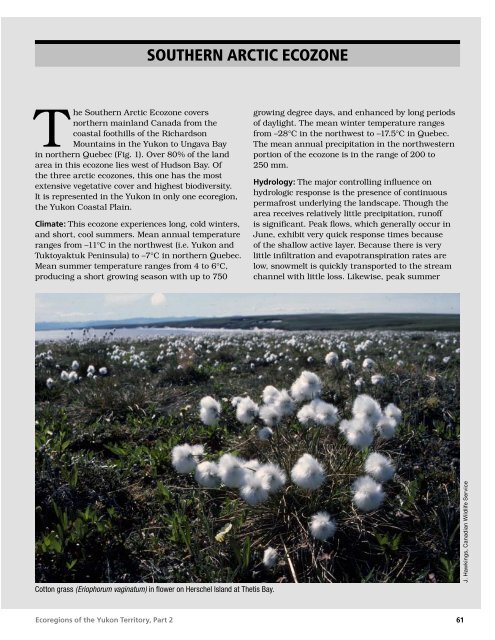
Cotton grass (Eriophorum vaginatum) in flower on Herschel Island at Thetis Bay.<br />
growing degree days, and enhanced by long periods<br />
of daylight. The mean winter temperature ranges<br />
from –28°C in the northwest to –17.5°C in Quebec.<br />
The mean annual precipitation in the northwestern<br />
portion of the ecozone is in the range of 200 to<br />
250 mm.<br />
Hydrology: The major controlling influence on<br />
hydrologic response is the presence of continuous<br />
permafrost underlying the landscape. Though the<br />
area receives relatively little precipitation, runoff<br />
is significant. Peak flows, which generally occur in<br />
June, exhibit very quick response times because<br />
of the shallow active layer. Because there is very<br />
little infiltration and evapotranspiration rates are<br />
low, snowmelt is quickly transported to the stream<br />
channel with little loss. Likewise, peak summer<br />
J. Hawkings, Canadian Wildlife Service<br />
61
J. Hawkings, Canadian Wildlife Service<br />
rain locally produces flash floods. Because of<br />
the relatively small streamflow generating areas,<br />
the largest streams in this part of the Yukon are<br />
relatively small compared with elsewhere in the<br />
ecozone. Many streams experience zero winter flow<br />
from November to April.<br />
Landforms and soils: Most of the <strong>Southern</strong> <strong>Arctic</strong><br />
<strong>Ecozone</strong> is underlain by Precambrian granitic<br />
bedrock, and the terrain consists largely of broadly<br />
rolling rocky uplands and intermittent lowlands.<br />
Much of it is mantled with discontinuous moraine,<br />
except in coastal areas and within much of the<br />
Yukon Coastal Plain Ecoregion, where fine-textured<br />
marine or glaciomarine sediments cover the surface.<br />
Thick glacial drift deposits characterize much of the<br />
westernmost section of the ecozone from Great Bear<br />
Lake to the Firth River on the Yukon coast. Strung<br />
out across the landscape are long, sinuous eskers,<br />
some reaching lengths of 100 km. A small part of<br />
the ecozone west of the Firth River is unglaciated.<br />
The undulating landscape is studded with<br />
innumerable lakes, ponds and wetlands. Cryosols,<br />
the dominant soils, are underlain by continuous<br />
permafrost with active layers that remain moist or<br />
wet throughout the summer.<br />
Vegetation: This ecozone covers the major area of<br />
vegetation transition between the taiga forest to<br />
the south and the polar desert conditions of the<br />
Northern <strong>Arctic</strong> <strong>Ecozone</strong>. The vegetative cover is<br />
dominated by shrubs, which decrease in size to the<br />
north. Typical shrubs include dwarf birch, willow,<br />
and heath species; these are commonly mixed with<br />
various herbs, lichens and mosses. Major river<br />
valleys, such as the Babbage, support scattered<br />
clumps of stunted spruce trees. Wetlands are<br />
common in the low-lying coastal areas, and mainly<br />
support sedge moss vegetation.<br />
White and intermediate phase snow geese photographed during<br />
late-summer staging along the Yukon Coastal Plain.<br />
62<br />
In this zone of continuous permafrost, the <strong>Arctic</strong> fox (Alopex lagopus)<br />
seeks out alluvial or well-drained sandy soils for den sites.<br />
Wildlife: A wide variety of mammals live in this<br />
ecozone. It includes the major summer range<br />
and calving grounds for Canada’s largest caribou<br />
herds, the barren-ground caribou in the west<br />
and the woodland caribou in the eastern portion<br />
of the ecozone. Other mammals include grizzly<br />
bear, black bear in northern Quebec, polar bear<br />
in coastal areas, wolf, moose, <strong>Arctic</strong> ground<br />
squirrel, and brown lemming. This ecozone is<br />
also a major breeding and nesting ground for a<br />
variety of migratory birds. Representative species<br />
include the Yellow-billed, <strong>Arctic</strong>, and Red-throated<br />
Loons; Tundra Swan; Snow Goose; Long-tailed<br />
Duck; Gyrfalcon; Willow and Rock Ptarmigan; Red<br />
Phalarope; Parasitic Jaeger; Snowy Owl; Hoary<br />
Redpoll; and Snow Bunting. Some typical marine<br />
species include walrus, seal, beluga whale, and<br />
narwhal.<br />
Human activities: This ecozone is sparsely<br />
populated. The total population of approximately<br />
10,300 is scattered in 17 communities, including<br />
Tuktoyaktuk, Paulatuk, and Coppermine in the<br />
west; Chesterfield Inlet, Rankin Inlet, and Eskimo<br />
Point on the coast of Hudson Bay; and Kangirsuk on<br />
Ungava Bay. Rankin Inlet is the largest centre with<br />
a population of 1,706. Much of the local economy<br />
is based on subsistence hunting, trapping, and<br />
fishing. Inuit and Inuvialuit form over 80% of the<br />
population. The mineral and hydrocarbon potential<br />
of the zone has also led to increased exploration<br />
and some extraction activity. Construction, some<br />
tourism, and government services are the other<br />
principal activities.<br />
Ecoregions of the Yukon Territory, Part 2<br />
B. McLean
6000<br />
5500<br />
5000<br />
4500<br />
4000<br />
3500<br />
3000<br />
2500<br />
2000<br />
1500<br />
1000<br />
500<br />
0<br />
Ecoregions of the Yukon Territory, Part 2<br />
Yukon Coastal Plain<br />
<strong>Southern</strong> <strong>Arctic</strong> <strong>Ecozone</strong><br />
ECOREGION 32<br />
DISTINGUISHING CHARACTERISTICS: This is the only ecoregion in the Yukon representative<br />
of southern arctic ecosystems and the only ecoregion in the Yukon with a marine<br />
coastline (Fig. 32-1). The Yukon Coastal Plain Ecoregion is home to populations<br />
of muskoxen, polar bear and <strong>Arctic</strong> fox and provides important summer range<br />
for the Porcupine caribou herd. Much of the land surface was glaciated by<br />
Laurentide ice moving westward from the Mackenzie Valley; the area west<br />
of Firth River is unglaciated.<br />
Figure 32-1. Driftwood, carried down river (principally the Mackenzie) from the Taiga and Boreal Cordillera ecozones, is strewn<br />
along the beaches of the Yukon Coastal Plain where no trees grow.<br />
APPROXIMATE LAND COVER<br />
tundra, 80%,<br />
lakes and wetlands, 20%<br />
Metres<br />
above<br />
sea level<br />
ELEVATIONAL RANGE<br />
0–585 m asl<br />
mean elevation 82 m asl<br />
TOTAL AREA<br />
OF ECOREGION<br />
IN CANADA<br />
6,380 km 2<br />
TOTAL AREA<br />
OF ECOREGION<br />
IN THE YUKON<br />
5,460 km 2<br />
ECOREGION AREA AS A<br />
PROPORTION OF THE YUKON<br />
1% (includes coastal<br />
lagoons/shallow water)<br />
CORRELATION TO OTHER ECOLOGICAL REGIONS: Northern portion of Northern Mountains and Coastal<br />
Plain Ecoregion (Oswald and Senyk, 1977) • Equivalent to Northern Coastal Plain Ecoregion (Wiken<br />
et al., 1981) • Yukon portion of Alaska Tundra Region (CEC, 1997) • Yukon portion of <strong>Arctic</strong> Coastal<br />
Tundra Ecoregion (Ricketts et al., 1999) • Contiguous with the Beaufort Coastal Plain Ecoregion of<br />
Alaska (Nowacki et al., 2001)<br />
63<br />
J. Hawkings, Canadian Wildlife Service
Yukon Coastal Plain • ECOREGION 32<br />
PHYSIOGRAPHY<br />
The Yukon Coastal Plain Ecoregion incorporates the<br />
Yukon Coastal Plain (Bostock, 1948; Hughes, 1987b)<br />
or Lowland (Mathews, 1986) physiographic unit<br />
(Fig. 2). The coastal plain is a band of land, north<br />
of the British, Barn and Richardson mountains,<br />
that slopes to the Beaufort Sea (Rampton, 1982). It<br />
extends inland along the Babbage and Blow rivers.<br />
The slope increases moving in a southerly direction<br />
away from the coast.<br />
Much of the plain is an erosion surface, or pediment,<br />
where the gentle slope is a result of a long period<br />
of uninterrupted erosion. Ongoing erosion carries<br />
material across the surface by soil creep and<br />
sheetwash. The surface of the pediment often<br />
intersects different rock types and bedding planes<br />
in the underlying bedrock. Eastern portions of the<br />
ecoregion are mantled with glacial drift, which<br />
imparts a rolling or hummocky nature to the<br />
surface (Rampton, 1982).<br />
Relief is generally less than 30 m. The elevation is<br />
generally less than 80 m asl in the west, except for<br />
Herschel Island with a maximum elevation of 185 m<br />
asl, and one of the Buckland Hills between the Firth<br />
and Malcolm rivers at 585 m asl is the highest point<br />
in the ecoregion. The elevation of the plain increases<br />
to the east where the surface lies between 150 and<br />
300 m asl. Streams have cut into the surface of the<br />
plain, typically between 3 m in the west to more<br />
than 150 m in the east. A coastal scarp is prominent<br />
in the eastern portion of the ecoregion but largely<br />
absent adjacent to the Alaska border. The greater<br />
relief in the east reflects isostatic rebound following<br />
retreat of the Laurentide Ice Sheet. The uplift results<br />
in downcutting by postglacial streams (Fig. 32-2).<br />
The Coastal Plain is incised with several large rivers,<br />
as well as smaller streams. From the west, they<br />
include the Malcolm, Firth, Babbage, Blow and Big<br />
Fish rivers. These rivers broaden into large alluvial<br />
fans where they meet the Beaufort Sea. Wetlands<br />
and small lakes are common along the Beaufort<br />
coast.<br />
BEDROCK GEOLOGY<br />
A veneer of glacial deposits, colluvium and alluvium<br />
covers most of this ecoregion, obscuring the<br />
bedrock, a pediment made of a Late Tertiary erosion<br />
surface. The distribution of underlying rock units is<br />
shown by Norris (1981a,b; 1985) and summarized<br />
64<br />
in Lane and Dietrich (1996). The region is part<br />
of the <strong>Arctic</strong> Alaska Terrane, which comprised<br />
the Foreland during the Tertiary compression<br />
stages of the Cordilleran orogeny. Fold and thrust<br />
structures project from the northern Richardson<br />
and Barn mountains northward beneath the coastal<br />
plain to the offshore Beaufort Foldbelt (Lane and<br />
Dietrich, 1995). The Rapid Depression beneath the<br />
northwestern half of the ecoregion is a V-shaped,<br />
northward-plunging, fault-controlled trough<br />
containing more than 4,000 m of Lower Cretaceous<br />
sandstone and conglomerate.<br />
The dominant rock types in this ecoregion are slates<br />
and shale of Paleozoic through Early Tertiary age;<br />
as a result exposures are few and crumbly, or have<br />
been reduced to fine-grained talus. Sandstone and<br />
minor chert produce blocky talus. The prominent<br />
rock pillar called Engigstciak is composed of early<br />
Ordovician chert. Mudstone and sandstone of the<br />
Upper Cretaceous Tent Island, and Lower Tertiary<br />
Moose Channel formations are exposed along the<br />
Big Fish River where it runs northeastward out of<br />
the Yukon Territory. Bluffs of dark-coloured shale<br />
and siltstone of the Jurassic Kingak Formation<br />
extend to the mouths of the Spring and Firth rivers,<br />
the latter exposing fine ammonite and crinoid<br />
fossils. In 1826, John Franklin noted lignite seams<br />
near the mouth of the Babbage River; these are<br />
within the Moose Channel Formation. The Reindeer<br />
Formation also contains bituminous coal: it has<br />
been mined near the mouth of Rapid Creek and<br />
at Shingle Point. Tertiary sandstone delta-fronts<br />
immediately offshore to the north have hydrocarbon<br />
potential, but these reservoir strata appear thinner<br />
and narrower than those in the Beaufort and<br />
Mackenzie Delta region to the east.<br />
SURFICIAL GEOLOGY AND<br />
GEOMORPHOLOGY<br />
The Yukon Coastal Plain can be subdivided into<br />
two main land units: the low relief, gently sloping<br />
coastal margin and the mountain fringe, which<br />
forms a narrow belt of land at the contact between<br />
the Richardson Mountains and the Coastal Plain<br />
itself (Rampton, 1982).<br />
The entire area is underlain by permafrost, and<br />
the coastal area is modified by shoreline processes.<br />
Thermokarst lakes, retrogressive thaw flow slides,<br />
non-sorted polygons and stripes, pingos and other<br />
periglacial features are common. Organic deposits<br />
Ecoregions of the Yukon Territory, Part 2
are found throughout the area, overlying most<br />
surficial geology units. Peat thickness ranges from<br />
0.3 to 3.5 m, influencing the thermal and moisture<br />
balance of the surface. Disturbance of the organic<br />
layer can result in thermokarst, which can produce<br />
soil subsidence, slumps, slides and gullies where the<br />
slope is greater than 5 degrees.<br />
Unglaciated terrain exists in the ecoregion west of<br />
Herschel Island. Surficial materials here consist<br />
of coalescent fluvial fans, terraces, sandy eolian<br />
deposits and fine-textured marine colluvial and<br />
lacustrine materials. Beaches, spits and bars are<br />
the common shoreline landforms through the extent<br />
of the Beaufort coastline.<br />
The low relief portion of the Coastal Plain includes<br />
several large fluvial fans, at the mouths of Craig<br />
and Clarence creeks, and the Malcolm, Firth and<br />
Babbage rivers. The fans west of the Firth River are<br />
mainly coarse-grained and contain less ice than<br />
the finer-grained, organic-rich fan deposits of the<br />
Babbage and Firth rivers. The lower parts of these<br />
fans, as well as the floodplains of most streams<br />
in the area, are unvegetated and have shifting<br />
channels.<br />
The easternmost boundary of the ecoregion includes<br />
a portion of the Mackenzie Delta. These deposits<br />
are fine-grained, organic and ice-rich, except for the<br />
talik zone under active channels.<br />
Moraines left by glaciers are found east of the Firth<br />
River, generally at elevations lower than 300 m<br />
asl (Rampton, 1982). The moraines cover large<br />
surfaces and have been modified by thermokarst,<br />
retrogressive thaw slides and other periglacial<br />
processes, such as solifluction and soil creep. They<br />
generally present a rolling to hummocky surface.<br />
The moraines are fairly rich in silt and clay and<br />
contain high volumes (10 to 40%) of segregated<br />
ice, in the form of ice lenses and ice wedges. The<br />
first 3 m of the moraines are usually a mixture of<br />
mudflow deposits, lacustrine sediments, colluvial<br />
moraine and ice. Two large ice-push features,<br />
Herschel Island and the ridge east of the Babbage<br />
River’s lowermost floodplain, are distinct from<br />
other glacial deposits of the area. They consist of<br />
unconsolidated sediments thrust by the front of<br />
overriding glaciers, now containing large bodies of<br />
ice-rich sediments and segregated ice.<br />
Ecoregions of the Yukon Territory, Part 2<br />
Large outwash deposits or glaciofluvial sand and<br />
gravel deposits are southeast of the Firth River,<br />
on the north side of the Tugulak River floodplain<br />
and a narrow band between Deep Creek and Blow<br />
River. These larger deposits formed as meltwater<br />
streams flowed along the southwestern edge of the<br />
Buckland glaciers. They have a low gradient and<br />
poor drainage, and are often covered by thick icerich<br />
organic deposits and punctuated by numerous<br />
shallow thermokarst ponds. A large esker runs<br />
between the Blow and Running rivers. Small<br />
glaciofluvial deposits located at higher elevations are<br />
usually well drained and have low ice content.<br />
Glacial lakes formed in several areas between the<br />
rising slope of the coastal and mountain fringe<br />
and the retreating glaciers. Ice-rafted boulders,<br />
beach lines and fine-grained sediments, ranging<br />
in thickness between 1.5 and 6 m, were left over<br />
older sediments. The glaciolacustrine deposits are<br />
usually poorly drained, low relief, ice-rich and often<br />
covered by peat. Thermokarst lakes, ice wedges and<br />
polygons are commonly seen in this kind of terrain.<br />
Colluvial deposits are associated with foothills of<br />
the Richardson and other mountain ranges to the<br />
south of the ecoregion. The colluvium is derived<br />
from local bedrock and frost-shattered debris moved<br />
through soil creep or solifluction, sometimes mixed<br />
with alluvium at the base of the slopes. Colluvium<br />
composition ranges from coarse boulder fields to<br />
fine-grained organic and ice-rich debris.<br />
GLACIAL HISTORY<br />
ECOREGION 32 • Yukon Coastal Plain<br />
The Yukon Coastal Plain includes both glaciated and<br />
unglaciated terrain. The boundary between these<br />
terrains is marked by the Late Wisconsinan absolute<br />
limit of the Laurentide Ice Sheet about 30,000<br />
years ago (Hughes et al., 1981; Lemmen et al.,<br />
1994; Duk-Rodkin and Hughes, 1995). The limit<br />
follows the northeastern front of the Richardson,<br />
Barn and British mountains, descending westward<br />
towards Herschel Island (Fig. 15). The ice sheet<br />
advanced across extensive late Cenozoic pediments,<br />
surfaces that extend from the foothills to the coast,<br />
descending from approximately 850 m asl at the<br />
east end of the coastal plain to almost sea level at<br />
the border with Alaska (Rampton, 1982). In addition<br />
to the Laurentide glacial maximum, two other welldefined<br />
former ice margins occur in this ecoregion.<br />
The first is the Katherine Creek Phase (ca. 22 ka;<br />
65
Yukon Coastal Plain • ECOREGION 32<br />
Duk-Rodkin and Hughes, 1991; Lemmen et al.,<br />
1994), traceable from southern Mackenzie Mountain<br />
to Deep Creek, a tributary to the Babbage River<br />
(Fig. 32-2). The other is the Tutsieta Lake Phase<br />
(ca. 13 ka; Hughes, 1987a; Duk-Rodkin and Hughes,<br />
1995) that follows the Peel River and the western<br />
edge of the Mackenzie Delta. The three former ice<br />
margins are considered correlative to the Buckland<br />
phase, Sabine phase (both from Rampton, 1982) and<br />
Late Wisconsinan limits of glaciation, respectively.<br />
CLIMATE<br />
This ecoregion has an arctic climate. Winters<br />
are prolonged, lasting from October through<br />
June. Summers are brief, with temperatures very<br />
dependent on whether the winds are onshore or<br />
offshore, with ice cover, even in summer, near the<br />
coast. Precipitation is light, but the winds are some<br />
of the strongest in the Yukon.<br />
Mean annual temperatures are –10 to –12°C;<br />
February is the coldest month near –28°C, with<br />
the mean maximum near –24°C and the mean<br />
minimum near –32°C. Above freezing temperatures<br />
can occur during the winter but are accompanied<br />
by strong winds. Extreme minimums are only<br />
near –50°C due to some heat transfer from the<br />
<strong>Arctic</strong> Ocean through the ice cover. July is the<br />
warmest month with means ranging from 8 to 10°C.<br />
Temperatures near 30°C have occurred during<br />
June, July and August, but fairly heavy frosts can<br />
also occur in these months.<br />
Annual precipitation is light, being between only 125<br />
and 200 mm. June through August has the heaviest<br />
precipitation, 20 to 35 mm, in the form of rain,<br />
drizzle, and occasional snow. The months of October<br />
to May have mean monthly amounts of 3 to 5 cm of<br />
snow.<br />
Winds are strong throughout the year with mean<br />
speeds near 20 km/hr. They are strongest from<br />
Figure 32-2. The Blow, Babbage (above), Firth and Malcolm rivers cut into the pedimont surface of the Yukon Coastal Plain, creating rare<br />
bedrock exposures. Deep Creek, a tributary to the Babbage River near this point, occupies a drainage channel, parallel to the coast, that<br />
formed along the front of the intermediate Laurentide glacial maximum, the Katherine Creek Phase.<br />
66<br />
Ecoregions of the Yukon Territory, Part 2<br />
C. Kennedy, Yukon Government
October through May; sustained winds of 50 to 80<br />
km/hr do occur. The prevailing direction is either<br />
from the west or from the east, although a southerly<br />
component can develop in the major valleys such<br />
as the Blow and Babbage rivers. These prevailing<br />
winds cause much redistribution of the light snow<br />
cover.<br />
Detailed historic climatic data are available from<br />
Komakuk Beach, Stokes Point and Shingle Point.<br />
As these stations are on the coast, summer<br />
temperatures are frequently higher some 2 to 3 km<br />
inland than reported by these stations. Currently,<br />
a limited range of weather data is collected by<br />
automated weather stations at Komakuk Beach and<br />
Shingle Point only.<br />
HYDROLOGY<br />
The Yukon Coastal Plain Ecoregion is situated<br />
within the <strong>Arctic</strong> Hydrologic Region (Fig. 8).<br />
The major direction of drainage is to the north<br />
into the Beaufort Sea. The ecoregion drains the<br />
northern foothill slopes of the British–Richardson<br />
Mountains Ecoregion, the relatively flat coastal<br />
plain that includes Herschel Island, and the western<br />
Mackenzie Delta. Numerous larger streams within<br />
the ecoregion originate in the British and the<br />
Richardson mountains, with streamflow response<br />
that is not characteristic of the ecoregion. These<br />
include the lower reaches of the Blow, Firth and<br />
Malcolm rivers. Because the ecoregion is long and<br />
narrow, there are no representative intermediate<br />
or large streams within the ecoregion. Small<br />
representative streams include Deep and Poland<br />
creeks. While there are no intermediate- or largesized<br />
lakes, the ecoregion contains numerous small<br />
pothole lakes and ponds. Lakes and wetlands<br />
are estimated to cover approximately 20% of the<br />
ecoregion.<br />
There are no historical representative hydrometric<br />
stations within the Yukon portion of the ecoregion,<br />
but there is one representative Alaskan station, at<br />
Nunavak Creek near Barrow. The Babbage River<br />
and Kaparuk River near Deadhorse are somewhat<br />
representative transitional basins, useful in<br />
characterizing the hydrologic response. Annual<br />
streamflow has an increase in discharge in May<br />
due to snowmelt, rising to a peak in June within<br />
the majority of streams. Summer rain events will<br />
produce secondary, and occasionally the annual<br />
peak flows, on some streams. Fall (September)<br />
Ecoregions of the Yukon Territory, Part 2<br />
streamflows are often high. The mean annual runoff<br />
is estimated to be relatively low with an ecosystem<br />
average of 168 mm, while mean seasonal and<br />
summer flows are estimated to be at 14.4 X 10 –3<br />
and 6.9 X 10 –3 m 3 /s/km 2 respectively. The mean<br />
annual flood is estimated to be among the highest<br />
of all Yukon ecoregions (on a unit-area basis) with a<br />
value of 175 X 10 –3 m 3 /s/km 2 . The mean maximum<br />
summer flow is estimated to have a value of 40 X<br />
10 –3 m 3 /s/km 2 . The minimum annual and summer<br />
flows are estimated at 0 and 0.6 X 10 –3 m 3 /s/km 2 ,<br />
respectively. Due to the dominant role of winter<br />
temperatures and permafrost on streamflow, all<br />
ecoregion streams experience no water flows from<br />
December to April.<br />
PERMAFROST<br />
ECOREGION 32 • Yukon Coastal Plain<br />
Permafrost is continuous beneath the tundra<br />
of the Yukon Coastal Plain Ecoregion. Ground<br />
temperatures in an exploration well drilled by<br />
Imperial Oil near Blow River indicate the base of<br />
permafrost in eastern portions of the ecoregion<br />
is about 240 m deep (Fig. 21). Equilibrium nearsurface<br />
temperatures at Blow River are calculated<br />
to be about –5.5°C (Burgess et al., 1982; their<br />
Figure 16). At the coast, ground temperatures may<br />
be lower, with –9°C recorded in a suite of holes<br />
drilled near Kay Point. In unglaciated portions of the<br />
North Slope of Alaska, permafrost is up to 700 m<br />
thick (Lachenbruch and Marshall, 1986), and the<br />
same may be expected in contiguous portions of the<br />
Yukon Coastal Plain west of the glacial limit.<br />
The near-surface layers of permafrost are often icerich<br />
(Mackay, 1983), and large masses of ground<br />
ice are regularly exposed in thaw slumps along the<br />
coast (Pollard and Dallimore, 1988). Some of these<br />
icy beds likely formed during regional permafrost<br />
aggradation following deglaciation (Mackay and<br />
Dallimore, 1992). Coastal recession is about<br />
10 m/yr at many points due to these highly erodable<br />
sediments (Mackay, 1963). Storms in September,<br />
when wave fetch is greatest, are the major erosion<br />
events (Dallimore et al., 1996).<br />
Ice wedges are ever-present features of the terrain.<br />
A warmer, regional, early-Holocene climate has<br />
been inferred from truncated ice wedges exposed<br />
at coastal sites (Harry et al., 1988; Burn, 1997).<br />
Occasionally, large icy bodies form when snowbanks<br />
accumulate at the foot of coastal bluffs and are<br />
covered by falling debris (Pollard and Dallimore,<br />
67
Yukon Coastal Plain • ECOREGION 32<br />
1988). Ground ice found within the glacial limit<br />
is thought to be generally formed after glaciation,<br />
but deformation of icy beds on Herschel Island may<br />
have occurred approximately 30 ka ago during<br />
their excavation by glacier ice from Herschel Basin,<br />
a depression almost equal in volume to the island,<br />
currently submerged between the island and the<br />
mainland (Mackay, 1959).<br />
As on the north coast of Alaska, the summer climate<br />
is warmer inland than at the coast (Romanovsky<br />
and Osterkamp, 1995; Burn, 1997), leading to<br />
an increase in active layer depth with distance<br />
inland. The active layer depth also varies with<br />
surficial materials, so that it is 30 to 40 cm in finegrained<br />
sediments, but over 1 m thick in gravels<br />
or sands (Rampton, 1982). Much of the terrain<br />
surface is hummocky (Mackay et al., 1961), due to<br />
cryoturbation and soil movement during thawing<br />
in the active layer (Mackay, 1980). The terrain<br />
contains some thermokarst lakes, though not to the<br />
proportion found in the Tuktoyaktuk Coastlands<br />
east of the ecoregion (Rampton, 1988).<br />
SOILS<br />
Soils in the eastern and central portions of the<br />
ecoregion are formed on glacial materials. In the<br />
extreme western portion of the ecoregion, soils are<br />
found on unglaciated pediments or on vast alluvial<br />
fans of the Firth, Malcolm and Clarence rivers. The<br />
soils of the Yukon Coastal Plain Ecoregion were<br />
described by Wiken et al. (1984) and in part by<br />
Welch and Smith (1990). Tarnocai (1986) mapped<br />
soils in the Firth River as well, and Smith et al.<br />
(1989) conducted a detailed soil and vegetation<br />
survey of Herschel Island.<br />
On the undulating glacial moraine that covers much<br />
of the ecoregion, shrub vegetation is associated with<br />
well-drained landscapes. Soils have active layers<br />
greater than 50 cm and show evidence of mild<br />
cryoturbation. These soils are classified as Orthic<br />
Turbic Cryosols. Closer to the coastal fringe, much of<br />
the low-lying landscape is characterized by brackish<br />
wetlands dominated by small waterbodies. There is<br />
minor peat accumulation in these wetlands, usually<br />
less than 40 cm, and soils are most often classified<br />
as Gleysolic Turbic Cryosols. There is evidence in<br />
eroding headwalls along the coast that 3 to 4 m of<br />
peat formed in the past, but peat does not seem to<br />
be accumulating to the same extent in modern soils<br />
of the ecoregion; lowland polygonal wetlands seldom<br />
68<br />
contain more than 50 cm of peat over perennially<br />
frozen mineral soils.<br />
On the unglaciated portion of the ecoregion,<br />
pediment surfaces tend to be composed of long<br />
gentle slopes at less than 10% grade with rather<br />
uniform tussock tundra and shrub tundra<br />
vegetation cover. These soils are for the most part<br />
Orthic Turbic Cryosols with active layers less than<br />
50 cm. The large active fans provide fresh alluvial<br />
materials to the landscapes. Older terraces have<br />
permafrost established within them, yet there has<br />
been little soil formation and weathering. These<br />
soils are Regosolic Static Cryosols. The more active<br />
floodplains, and localized dune fields adjacent to<br />
the coast, do not have permafrost within 1 m of the<br />
surface and are classified as Orthic Regosols. These<br />
coarse-textured regosolic soils are relatively rare in<br />
the ecoregion but are important denning sites for<br />
foxes and wolves (Smith et al., 1988; 1991)<br />
Glacial ice-thrust marine sediments occur near<br />
King Point and form Herschel Island. Orthic Turbic<br />
Cryosols and associated patterned ground are the<br />
most common soils associated with the upland<br />
of the island (Fig. 32-3). Abundant thermokarst<br />
activity creates large fresh surfaces for renewed soil<br />
development. These scar areas are widespread on<br />
Herschel Island and Regosolic Static Cryosols are<br />
most commonly associated with them (Smith et al.,<br />
1989).<br />
VEGETATION<br />
The vegetation of the Yukon Coastal Plain Ecoregion<br />
reflects its major physiographic features, including<br />
the marine coastline, low-lying polygonal wetlands,<br />
tussock tundra, broad alluvial fans and deltas, and<br />
rolling hills flanking the Richardson Mountains<br />
(Fig. 32-4).<br />
The coastal areas support early-succession vegetation<br />
on beaches and spits, and littoral graminoid<br />
communities on estuaries and the shores of brackish<br />
lagoons. Development of salt marshes is inhibited<br />
compared with lower latitudes, due to sea ice<br />
abrasion, low tidal amplitudes and erosion. Massive<br />
thaw slumps, which build at the foot of the melting<br />
faces of cliffs of frozen sediments, are colonized<br />
by dense stands of mastodon flower (Smith et al.,<br />
1989).<br />
Ecoregions of the Yukon Territory, Part 2
The low inland terrain is covered by extensive<br />
wetlands and cottongrass tussock tundra (Hawkings<br />
1999). Freestanding sedges, marsh grass and<br />
willows have colonized wet sites, such as low centre<br />
polygons, the margins of ponds and thermokarst<br />
lakes, beaded drainages and ice wedge channels.<br />
Tussocks of cotton grass, growing in association<br />
with various ericaceous shrubs, lichens and forbs,<br />
dominate well-drained sites, such as high-centre<br />
polygons or pediments.<br />
Major drainages flowing from the mountains<br />
dissect the coastal plain in a north–south direction.<br />
The massive active alluvial fans of rivers like the<br />
Malcolm and Firth, with their constantly changing<br />
network of channels, exhibit various stages of<br />
succession. The active channels remain scoured and<br />
unvegetated, while stabilized gravel bars and fluvial<br />
terraces are gradually vegetated by bear root, lupine,<br />
dryas and willow.<br />
In contrast, the floodplains of other major but less<br />
active drainages, like the Babbage River, support<br />
well-established vegetation, such as sedges, willows,<br />
alders and, in the Mackenzie Delta, trees.<br />
Ecoregions of the Yukon Territory, Part 2<br />
?<br />
In the foothills of the northern mountains rising<br />
above the coastal plain, site drainage is improved;<br />
gentle slopes are vegetated with shrub birch and<br />
willow, dryas, lichen and prostrate willows.<br />
WILDLIFE<br />
ECOREGION 32 • Yukon Coastal Plain<br />
Figure 32-3. Frost action in the active layer of the fine-textured Cryosolic soils on Herschel Island and elsewhere in the ecoregion produces<br />
patterned ground. Patches of bare ground are set within a matrix of tundra vegetation.<br />
Mammals<br />
The Yukon Coastal Plain is the only ecoregion in<br />
the Yukon normally inhabited by <strong>Arctic</strong> fox, barrenground<br />
shrew, polar bear and muskoxen, although<br />
these species are occasionally seen further south<br />
(Jingfors, 1989). <strong>Arctic</strong> fox winter on offshore ice;<br />
however, they whelp and raise their young on land<br />
using traditional den sites. Summer fox activity<br />
is most prevalent on Herschel Island (Smits and<br />
Slough, 1993). The winter <strong>Arctic</strong> fox coat is white;<br />
the blue phase is not found here. Muskoxen, native<br />
to the arctic west of the Mackenzie River until<br />
extirpation by hunters in the 19th century, have<br />
immigrated to the Yukon Coastal Plain from a<br />
herd reintroduced to the coastal plain in Alaska<br />
between 1967 and 1970 (Alaska Geographic Society,<br />
S. Smith, Agriculture and Agri-Food Canada<br />
69
Yukon Coastal Plain • ECOREGION 32<br />
<br />
70<br />
<br />
<br />
<br />
<br />
<br />
<br />
<br />
<br />
<br />
<br />
<br />
<br />
<br />
<br />
<br />
<br />
<br />
<br />
<br />
<br />
<br />
<br />
<br />
<br />
<br />
<br />
<br />
<br />
<br />
<br />
<br />
<br />
<br />
<br />
<br />
<br />
<br />
<br />
<br />
<br />
<br />
<br />
<br />
<br />
<br />
<br />
<br />
<br />
<br />
<br />
<br />
<br />
<br />
<br />
<br />
<br />
<br />
<br />
<br />
<br />
<br />
<br />
<br />
<br />
<br />
<br />
<br />
<br />
<br />
<br />
<br />
<br />
<br />
<br />
<br />
<br />
<br />
<br />
<br />
<br />
<br />
<br />
<br />
<br />
<br />
<br />
<br />
<br />
<br />
<br />
<br />
<br />
<br />
<br />
<br />
<br />
<br />
<br />
<br />
<br />
<br />
<br />
<br />
<br />
<br />
<br />
<br />
<br />
<br />
<br />
<br />
<br />
<br />
<br />
<br />
Figure 32-4. Schematic profile<br />
of soil and vegetation patterns<br />
across the Yukon Coastal Plain<br />
Ecoregion between the foothills of<br />
the Richardson Mountains and the<br />
Beaufort Sea coast. Stippled portion<br />
shows approximate thickness and<br />
extent of soil parent materials over<br />
bedrock. Note exaggerated vertical<br />
scale.<br />
Ecoregions of the Yukon Territory, Part 2
1981). The Yukon herd in 1995 numbered about<br />
120 individuals, with another 30 or so roaming the<br />
region alone or in small groups (Fig. 32-5).<br />
The Porcupine barren-ground caribou herd was<br />
estimated at 160,000 individuals in 1995 and<br />
123,000 in 2001. During spring, the herd migrates<br />
north from their wintering grounds to the coastal<br />
plain in Alaska and the Yukon (Fancy et al., 1994).<br />
Calving is concentrated in the foothills of the British<br />
Mountains, but extends to the coast (Fig. 32-6).<br />
Pre- and post-calving aggregations of both sexes<br />
use the area. A fall migration returns the herd to<br />
winter range in Alaska, the Northwest Territories,<br />
and the Yukon, south to the Ogilvie and Mackenzie<br />
mountains.<br />
The ranges of several mammal species that occupy<br />
forested or alpine habitats extend to the coastal<br />
plain, including those of the meadow vole, northern<br />
vole, red-backed vole, wolverine, short-tailed weasel,<br />
wolf, red fox, grizzly bear, and moose (Youngman,<br />
1975). Grizzly bears are not as abundant as they<br />
are in the British–Richardson Mountains Ecoregion<br />
(Nagy, 1990). Moose are restricted to riparian<br />
habitats and are not abundant (Smits, 1991).<br />
Muskrat occupy the lowland lakes of the Mackenzie<br />
Delta. Typical small mammals include the collared<br />
Ecoregions of the Yukon Territory, Part 2<br />
ECOREGION 32 • Yukon Coastal Plain<br />
lemming, brown lemming, and tundra vole.<br />
Although populations of these rodents are cyclic<br />
elsewhere in the arctic, these species do not appear<br />
to fluctuate greatly in the Yukon. The <strong>Arctic</strong> fox<br />
and avian predator populations cycle every three<br />
to five years, but this is most likely due to waves of<br />
Figure 32-5. Muskoxen (Ovibos moschatus) were extirpated from<br />
the Yukon Coastal Plain by hunters in the 19th century. Individuals<br />
have immigrated to the area from a herd reintroduced to the Alaskan<br />
Coastal Plain between 1967 and 1970.<br />
Figure 32-6. Caribou grazing on the sedge tundra of the Yukon Coastal Plain Ecoregion near the mouth of the Firth River in late summer. The<br />
abrupt change in topography in the background marks the boundary with the adjacent British–Richardson Mountains Ecoregion.<br />
B. McLean<br />
J. Hawkings, Canadian Wildlife Service<br />
71
Yukon Coastal Plain • ECOREGION 32<br />
immigrants from adjacent cyclic populations. Tundra<br />
hares, arctic residents of Alaska and the Northwest<br />
Territories, are absent from the Yukon.<br />
The overall mammalian diversity of the ecoregion<br />
is very low due to low productivity, a harsh<br />
environment, and a similarly low diversity of<br />
habitats. Mammal species known or expected to<br />
occur in this ecoregion are listed in Table 4.<br />
Birds<br />
Unlike the suitability for mammals, the Yukon<br />
Coastal Plain is one of the richest areas in the<br />
territory for birds. The avian community here is<br />
unique in the Yukon, featuring many species that do<br />
not nest elsewhere in the territory. As well, some of<br />
the highest nesting densities for many other Yukon<br />
species occur in this ecoregion.<br />
From early June to mid-August, lowland tundra,<br />
sedge marshes, and small river deltas along the<br />
coast provide breeding habitat for a number of<br />
species that do not nest elsewhere in the territory.<br />
These include Brant;, Parasitic Jaeger; Glaucous<br />
Gull; Semipalmated, Pectoral, and Buff-breasted<br />
Sandpipers; Long-billed Dowitcher; Red Phalarope;<br />
and Lapland Longspur. Other species which<br />
commonly nest along coastal fringes of the ecoregion<br />
are Red-throated and Pacific Loons, Tundra Swan,<br />
Greater White-fronted Goose, Greater and Lesser<br />
Scaup, Red-breasted Merganser, Long-tailed Duck,<br />
American Widgeon, Mallard, Northern Shoveler,<br />
Northern Pintail, Green-winged Teal, Sandhill<br />
Crane, Common Snipe, Red-necked Phalarope, Longtailed<br />
Jaeger, and <strong>Arctic</strong> Tern (Salter et al., 1980;<br />
Sinclair et al. [editors], 2003).<br />
Gravel beds of creeks and rivers provide nest sites<br />
for Semipalmated Plover and Spotted Sandpiper.<br />
Driftwood-strewn beaches along the Beaufort Sea<br />
are nesting areas for Common Eider and Glaucous<br />
Gull, which breed in the Yukon only in this<br />
ecoregion, as well as Snow Bunting. Mud banks<br />
of larger creeks and rivers house small colonies of<br />
Bank Swallow.<br />
The upland tundra most prevalent on Herschel<br />
Island and the western portion of the ecoregion<br />
supports breeding species such as Rock Ptarmigan,<br />
American Golden-Plover, Baird’s Sandpiper, Ruddy<br />
72<br />
Turnstone, Horned Lark, American Pipit, and<br />
occasionally Snowy Owl and Smith’s Longspur.<br />
Remarkably high densities of Rough-legged Hawk<br />
nest on ledges and pinnacles of coastal bluffs<br />
and inland ravines on Herschel Island (Ward and<br />
Mossop, 1985); this is the only Yukon ecoregion<br />
where the tundra race of Peregrine Falcon nests.<br />
On Herschel Island, abandoned buildings at Pauline<br />
Cove are occupied by one of only six breeding<br />
colonies of Black Guillemot in the western <strong>Arctic</strong><br />
(Ward and Mossop, 1985).<br />
Shrubby habitats on the tundra and along some<br />
lakes, ponds, draws, and creeks support breeding<br />
Willow Ptarmigan, Common and Hoary Redpolls,<br />
Savannah, American Tree, and White-crowned<br />
Sparrows. Taller shrubs along larger creeks and<br />
rivers of the eastern half of the Coastal Plain<br />
support Northern Shrike, Gray-cheeked Thrush,<br />
American Robin, Yellow Warbler, and Fox Sparrow<br />
(Salter et al., 1980). Two other species found in<br />
shrubby habitats, Bluethroat and Yellow Wagtail, are<br />
predominantly Eurasian in their distribution and do<br />
not occur elsewhere in Canada (Black, 1972; Taylor<br />
and Judge, 1974; Eckert, 1995b).<br />
While spring migration along the coast is<br />
unremarkable, some spectacular staging and<br />
migration events occur in late summer and fall.<br />
Thousands of Snow Geese feed on the coastal plain<br />
from late August through mid-September (Hawkings,<br />
1987) and thousands of Red-necked and hundreds<br />
of Red Phalarope stage along the coast in August<br />
(Ealey et al., 1988). Also notable are thousands of<br />
moulting sea ducks, mostly Long-tailed Duck and<br />
Surf Scoter, which gather in Workboat Passage,<br />
between the mainland and Herschel Island, in<br />
July and August. Migration along the coast is both<br />
eastward toward the Mackenzie River delta and<br />
westward toward the Alaskan coast, depending on<br />
the species. Small river deltas, spits, and lagoons<br />
along the coast are used for resting and feeding<br />
by many waterfowl and shorebird species (Eckert,<br />
1997b, 1998b).<br />
While data are limited, the only species known to<br />
occur in winter are Gyrfalcon, Willow and Rock<br />
Ptarmigans, Snowy Owl, and Common Raven (Salter<br />
et al., 1980).<br />
Ecoregions of the Yukon Territory, Part 2