Muskwa Plateau Ecoregion
Muskwa Plateau Ecoregion
Muskwa Plateau Ecoregion

Create successful ePaper yourself
Turn your PDF publications into a flip-book with our unique Google optimized e-Paper software.
6000<br />
5500<br />
5000<br />
4500<br />
4000<br />
3500<br />
3000<br />
2500<br />
2000<br />
1500<br />
1000<br />
500<br />
0<br />
<strong>Ecoregion</strong>s of the Yukon Territory, Part 2<br />
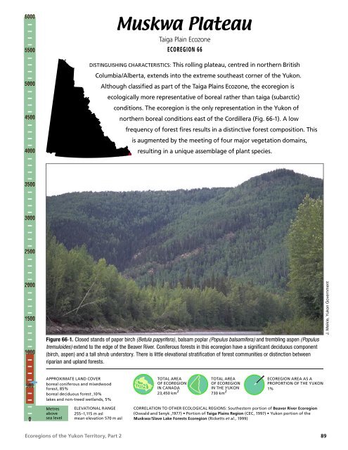
<strong>Muskwa</strong> <strong>Plateau</strong><br />
Taiga Plain Ecozone<br />
ECOREGION 66<br />
DISTINGUISHING CHARACTERISTICS: This rolling plateau, centred in northern British<br />
Columbia/Alberta, extends into the extreme southeast corner of the Yukon.<br />
Although classified as part of the Taiga Plains Ecozone, the ecoregion is<br />
ecologically more representative of boreal rather than taiga (subarctic)<br />
conditions. The ecoregion is the only representation in the Yukon of<br />
northern boreal conditions east of the Cordillera (Fig. 66-1). A low<br />
frequency of forest fires results in a distinctive forest composition. This<br />
is augmented by the meeting of four major vegetation domains,<br />
resulting in a unique assemblage of plant species.<br />
Figure 66-1. Closed stands of paper birch (Betula papyrifera), balsam poplar (Populus balsamifera) and trembling aspen (Populus<br />
tremuloides) extend to the edge of the Beaver River. Coniferous forests in this ecoregion have a significant deciduous component<br />
(birch, aspen) and a tall shrub understory. There is little elevational stratification of forest communities or distinction between<br />
riparian and upland forests.<br />
APPROXIMATE LAND COVER<br />
boreal coniferous and mixedwood<br />
forest, 85%<br />
boreal deciduous forest ,10%<br />
lakes and non-treed wetlands, 5%<br />
Metres<br />
above<br />
sea level<br />
ELEVATIONAL RANGE<br />
255–1,115 m asl<br />
mean elevation 570 m asl<br />
TOTAL AREA<br />
OF ECOREGION<br />
IN CANADA<br />
23,450 km 2<br />
TOTAL AREA<br />
OF ECOREGION<br />
IN THE YUKON<br />
730 km 2<br />
ECOREGION AREA AS A<br />
PROPORTION OF THE YUKON<br />
1%<br />
CORRELATION TO OTHER ECOLOGICAL REGIONS: Southestern portion of Beaver River <strong>Ecoregion</strong><br />
(Oswald and Senyk ,1977) • Portion of Taiga Plains Region (CEC, 1997) • Yukon portion of the<br />
<strong>Muskwa</strong>/Slave Lake Forests <strong>Ecoregion</strong> (Ricketts et al., 1999)<br />
J. Meikle, Yukon Government<br />
89
<strong>Muskwa</strong> <strong>Plateau</strong> • ECOREGION 66<br />
PHYSIOGRAPHY<br />
The <strong>Muskwa</strong> <strong>Plateau</strong> <strong>Ecoregion</strong> is represented in<br />
the Yukon as a small triangle of land lying north<br />
and west of the Liard River in the extreme southeast<br />
of the territory. This small southeast corner of the<br />
Yukon is part of a larger ecoregion that extends<br />
south into British Columbia. This ecoregion is part<br />
of the Alberta–Great Slave Plain Physiographic<br />
Region (Mathews, 1986) or Interior Plains region<br />
of Bostock (1948), which lies east of the Western<br />
Cordillera.<br />
The subdued topography slopes south and east<br />
toward the Liard River. The elevation ranges from<br />
over 1,100 m asl on the ridge south of Mount Martin,<br />
a southern extension of the Kotaneelee Range south<br />
of the La Biche River, to below 300 m on the plain of<br />
the Liard River. Local relief is about 450 m.<br />
The La Biche and Beaver rivers, and their<br />
tributaries, follow the northeast–southwest trend of<br />
the bedrock before cutting through the ridges in a<br />
more easterly direction (Fig. 66-2).<br />
BEDROCK GEOLOGY<br />
Bedrock exposure is limited to the Kotaneelee River<br />
west of Mount Martin and along the Beaver River<br />
at 60°N. The surficial sediments elsewhere contain<br />
abundant glacially transported debris so that the<br />
underlying shale and sandstone are unlikely to<br />
influence overlying soil and vegetative cover.<br />
The regional geology is shown by Douglas (1976);<br />
structural and stratigraphic information has been<br />
acquired by companies with oil and gas leases in the<br />
region. Beneath the surficial material, sedimentary<br />
rocks form broad folds that are the easternmost<br />
expression of the northern Rocky Mountains. The<br />
northern edge of the ecoregion is traced around<br />
an anticline that forms the Kotaneelee Range, and<br />
most of the ecoregion is underlain by the adjacent<br />
La Biche syncline. Rusty-weathering, concretionbearing<br />
shale, with lesser grey-green sandstone and<br />
siltstone, comprises the Lower Cretaceous Fort Saint<br />
John Group. The units beneath them, only exposed<br />
on the flank of the syncline along the northwest<br />
Figure 66-2. The Labiche River cuts through the southernmost Kootanelee Range, having been diverted eastward by the most recent<br />
glaciation. Physiography and climate combine in this ecoregion to produce a fire cycle that is longer than in most of the boreal. Windthrow<br />
and insects are the more common agents of forest disturbance.<br />
90<br />
<strong>Ecoregion</strong>s of the Yukon Territory, Part 2<br />
J. Meikle, Yukon Government
edge of the ecoregion, are grey-banded chert and<br />
sandstone of the Permian Fantasque Formation<br />
and grey siltstone, limestone, and shale of the<br />
Carboniferous-to-Permian Mattson Formation.<br />
Within the Yukon portion of this ecoregion are two<br />
established petroleum fields and a sizeable region<br />
with high potential (National Energy Board, 1994).<br />
The Beaver River gas field, which straddles the<br />
British Columbia border, was discovered in 1957<br />
and produced from 1969 to 1978 before being closed<br />
by water influx, although new techniques may allow<br />
further production. The Kotaneelee field, discovered<br />
in 1964, has been producing since 1993. However,<br />
most of the natural gas wells lie in the adjacent<br />
Northwest Territories, in the Liard and Pointed<br />
Mountain fields, and adjacent British Columbia. The<br />
principal reservoir is the Manetoe facies of Devonian<br />
limestone (Morrow et al., 1990) that lies 2,500 to<br />
3,500 m beneath the surface.<br />
SURFICIAL GEOLOGY AND<br />
GEOMORPHOLOGY<br />
The ecoregion was glaciated and glacial deposits<br />
are the dominant surficial unconsolidated material.<br />
Despite widespread evidence of pro-glacial lakes in<br />
the eastern valleys as the continental ice receded,<br />
the valleys have been largely swept clean of<br />
Quaternary fill by postglacial rivers. These rivers<br />
eroded a series of peneplains into bedrock, leaving<br />
bouldery lag deposits in valley bottoms. The modern<br />
rivers are underfit for the valleys they occupy.<br />
Postglacial downcutting has affected areas of<br />
abundant glaciolacustrine sediments, resulting in<br />
extensive landslides throughout the valley bottoms.<br />
About 20% of the Yukon portion of the ecoregion<br />
has undergone mass movement, and some are<br />
kilometres in extent. The movement continues today<br />
and represents a significant hazard to existing and<br />
future development (I.R. Smith, pers. comm., 2000).<br />
Failure of the Mattson Formation sandstone along<br />
steeply dipping bedding planes is commonly<br />
triggered by undercutting of slopes by rivers and<br />
streams. Block sliding, rotational slumps and<br />
soil creep are typical results. The overlying thick,<br />
clay-rich glaciolacustrine sediment and local till<br />
accumulations are also mobilized. Some of these<br />
flows extend several kilometres and can block<br />
local drainages, leading to later failures of these<br />
temporary dams.<br />
<strong>Ecoregion</strong>s of the Yukon Territory, Part 2<br />
GLACIAL HISTORY<br />
Although the area is dominated by glacial features of<br />
the Cordilleran Ice Sheet that flowed across the area<br />
from the southwest to the northeast about 23,000<br />
years ago, it was also affected by the Laurentide<br />
Ice Sheet a few thousand years earlier (30 ka; Duk-<br />
Rodkin and Hughes, 1995; Lemmen et al., 1995;<br />
Duk-Rodkin et al., 1986). The Laurentide Ice Sheet<br />
moved westward across the Kotaneelee Range as far<br />
west as the confluence of the Whitefish and Beaver<br />
rivers. Deglaciation eroded a series of meltwater<br />
channels. Meltwater from the continental ice<br />
flowed west and north across the La Biche Range,<br />
depositing an outwash delta there. Etanda Lakes<br />
are located at the apex of the delta. The middle and<br />
northern reaches of the La Biche Range supported<br />
small valley glaciers during the last glaciation in the<br />
area.<br />
Drainage of the La Biche and Kotaneelee rivers<br />
was glacially altered. Before the last glaciation,<br />
the Kotaneelee River drained south between the<br />
La Biche and Kotaneelee ranges and was probably<br />
a tributary to the Beaver River. The Laurentide<br />
Ice Sheet eroded a channel oriented east-west<br />
across the Kotaneelee Range (Fig. 66-2) and<br />
deposited enough drift in the southern part of the<br />
valley that the direction of the river changed from<br />
south to east following glaciation. Later, when the<br />
Cordilleran Ice Sheet approached the ranges, it cut<br />
a northward channel across the drift barrier. This<br />
allowed meltwater to drain into the now east-flowing<br />
Kotaneelee River. The Cordilleran Ice Sheet also<br />
changed the drainage of the La Biche River by<br />
diverting it eastward across the La Biche Range, and<br />
later across the Kotaneelee Range, thereby creating<br />
the present zigzag pattern of the river.<br />
CLIMATE<br />
ECOREGION 66• <strong>Muskwa</strong> <strong>Plateau</strong><br />
No climate data are available for this ecoregion. The<br />
description of climate given for the Hyland Highland<br />
<strong>Ecoregion</strong> would apply in a general way for this<br />
ecoregion. As elevations in the <strong>Muskwa</strong> <strong>Plateau</strong><br />
ecoregion are generally less than 1000 m asl, station<br />
data from Fort Liard, Northwest Territories, would<br />
be most applicable to the area covered by this<br />
ecoregion.<br />
91
<strong>Muskwa</strong> <strong>Plateau</strong> • ECOREGION 66<br />
HYDROLOGY<br />
The <strong>Muskwa</strong> <strong>Plateau</strong> ecoregion is located in the<br />
very southeastern corner of the Yukon within the<br />
Interior Hydrologic region. Outside of the Yukon,<br />
this long and very narrow ecoregion drains the<br />
eastern foothills of the Rocky Mountains of Northern<br />
British Columbia. Within the Yukon, drainage<br />
is to the southeast from the La Biche Range of<br />
the eastern Mackenzie Mountains. Because of<br />
its small size, there are no representative large<br />
or intermediate-sized streams within the Yukon<br />
portion of the ecoregion. Though the La Biche River<br />
forms the eastern boundary of the ecoregion, and<br />
the Beaver River flows through the southwestern<br />
corner, these streams are not representative of the<br />
entire ecoregion. There are no large lakes within the<br />
ecoregion. There are scattered wetlands within the<br />
ecoregion; one notable complex exists within the<br />
Ottertail Creek valley between the Mount Martin<br />
and Mount Merrill ridges.<br />
Hydrometric stations with similar topography to<br />
that of the Yukon portion of the <strong>Muskwa</strong> <strong>Plateau</strong><br />
<strong>Ecoregion</strong> were chosen to represent streamflow<br />
characteristics. Because of lower relief within the<br />
small Yukon portion of the ecoregion, it is not<br />
truly representative of the remainder of the British<br />
Columbia portion. Also because of the relatively<br />
low relief, runoff and peak flow events are relatively<br />
low. Annual streamflow is characterized by an<br />
increase in discharge in early May due to snowmelt,<br />
rising to a peak later in the month within most<br />
ecosystem streams. Summer rain events do produce<br />
secondary peaks, and sometimes the annual peak,<br />
in July or August. Smaller streams are known to<br />
experience peak rainfall events more frequently<br />
than larger ones. Mean annual runoff is estimated<br />
to be 169 mm, while mean seasonal and mean<br />
summer flow are estimated to be moderate at<br />
9.4 X 10 –3 and 8.7 X 10 –3 m 3 /s/km 2 , respectively.<br />
The mean annual flood is estimated as relatively<br />
high at 131 X 10 –3 m 3 /s/km 2 , while the mean<br />
maximum summer flow is estimated to be more<br />
moderate with a value of 46 X 10 –3 m 3 /s/km 2 . The<br />
minimum annual and summer flows are estimated<br />
to be relatively low with values of 0.25 X 10 –3 and<br />
0.51 X 10 –3 m 3 /s/km 2 , respectively. Minimum<br />
streamflow generally occurs during March or earlier.<br />
The majority of streams experience zero winter flows<br />
relatively frequently.<br />
92<br />
PERMAFROST<br />
<strong>Muskwa</strong> <strong>Plateau</strong> is in the zone of sporadic<br />
discontinuous permafrost. The elevation is<br />
insufficient for alpine permafrost to form. Permafrost<br />
in the ecoregion is restricted to organic soils, and is<br />
likely less than 4 m thick. There are no published<br />
reports on permafrost from the Yukon portion of this<br />
ecoregion.<br />
SOILS<br />
Soils in this ecoregion have formed under a moist<br />
continental climate, somewhat milder and wetter<br />
than the adjacent Hyland Highland <strong>Ecoregion</strong>.<br />
Soil development reflects the mineralogy of<br />
the underlying Cretaceous calcareous shales<br />
and sandstones. Where soil parent materials<br />
are fine textured, such as clay loam moraine<br />
or glaciolacustrine materials, Brunisolic Gray<br />
Luvisols dominate the landscape. These Luvisols<br />
are highly productive forest soils found commonly<br />
throughout the Plains Ecozone. Eutric Brunisols<br />
are the common soils on coarse-textured, welldrained<br />
portions of the landscape (Zoladeski and<br />
Cowell, 1996). Orthic and Humic Gleysols occur<br />
in depressions on imperfectly and poorly drained<br />
mineral soils.<br />
Wetlands are extensive, covering more than<br />
a quarter of the British Columbia part of this<br />
ecoregion, but are much less common in the Yukon<br />
portion. Organic Cryosols are common on peat<br />
plateau bogs and some veneer bogs (Zoltai et al.,<br />
1988). Northern ribbed fens are common and lack<br />
permafrost. Fen soils are most commonly classified<br />
as Fibrisols or Mesosols.<br />
VEGETATION<br />
The vegetation cover is mixed boreal forest.<br />
The continental climate, with warmer, moister<br />
summers and relatively lower fire frequency than<br />
cordilleran ecoregions to the west, is reflected in the<br />
lush vegetation and high species diversity of this<br />
ecoregion. Fluvial sites in this area are the most<br />
productive in the Yukon. Trees on upland sites can<br />
reach more than 30 m in height (Applied Ecosystem<br />
Management, 1997b).<br />
Though the region is dominated by northern boreal<br />
white and black spruce (Annas, 1977; Trowbridge<br />
et al., 1983), occasional tall fern meadows and<br />
<strong>Ecoregion</strong>s of the Yukon Territory, Part 2
J. Meikle, Yukon Government<br />
devil’s club, typical of more southern forests,<br />
differentiate the Yukon part of this ecoregion from<br />
other parts of the Yukon and possibly other parts of<br />
the ecoregion. This area supports some plant species<br />
not found immediately south of the ecoregion.<br />
As throughout the boreal forest, forest fires have a<br />
significant influence on forest composition. However,<br />
parts of this ecoregion show little evidence of fire<br />
over at least 250 years, the result in part of higher<br />
summer precipitation and a lower incidence of<br />
lightning. Forest composition and renewal on these<br />
sites appears to be controlled by the interactions<br />
between soil characteristics, insects and diseases.<br />
The resultant mixed forest canopy includes white<br />
spruce, black spruce, paper birch, trembling aspen<br />
and balsam poplar (Fig. 66-1).<br />
White spruce–feathermoss forests form the<br />
dominant climax community found on moderately<br />
to rapidly drained fluvial deposits and moraine.<br />
Shrubs, such as highbush cranberry, rose, dwarf<br />
raspberry, red-osier dogwood, and green and<br />
gray alder, are common. Herbs include horsetail,<br />
bunchberry, mitrewort, bluebell and twinflower.<br />
As indicated above, ferns and devil’s club are also<br />
present (Fig. 66-3).<br />
Black spruce is more common on poorly drained<br />
sites usually with a Labrador tea and feathermoss<br />
understory. On moist and wet nutrient-rich sites,<br />
tamarack is occasionally found with black spruce.<br />
Subalpine fir is common at elevations over 750 m<br />
asl. Lodgepole pine does occur in one large burn<br />
in the Yukon portion of the ecoregion, but is not<br />
<strong>Ecoregion</strong>s of the Yukon Territory, Part 2<br />
common elsewhere. Aspen also forms pure stands in<br />
this old burn.<br />
Balsam poplar, paper birch and aspen frequently<br />
grow on disturbed sites, such as slumps found along<br />
the La Biche River. They are also found in mixed<br />
forest stands with white spruce. Graminoids with<br />
shrub birch and Potentilla palustris dominate the<br />
fens which border many of the lakes.<br />
WILDLIFE<br />
ECOREGION 66• <strong>Muskwa</strong> <strong>Plateau</strong><br />
Mammals<br />
Wood bison were historically present; the last one<br />
was shot in 1879 in British Columbia (Cowan<br />
et al., 1973). A bison herd, re-established in British<br />
Columbia in the 1950s, occasionally ranges into the<br />
Yukon. Other species entering the Yukon near their<br />
northern limit of distribution here are mule deer and<br />
fisher. Black bears, moose and wolves are common.<br />
Although this ecoregion is botanically productive,<br />
it does not provide suitable habitats for many of<br />
the rodent and ungulate species found in Boreal<br />
Cordillera ecoregions. Mammal species known or<br />
expected to occur in this ecoregion are listed in<br />
Table 4.<br />
Several bat species, including the western longeared<br />
myotis, northern long-eared myotis, longlegged<br />
myotis, big brown bat, and silver-haired<br />
bat, have recently been found in this ecoregion in<br />
British Columbia (Wilkinson et al., 1995). Bats have<br />
Figure 66-3. Devil’s club<br />
(Oplopanax horridus) in the Lower<br />
Beaver River valley. The valley has<br />
a unique array of vascular plants<br />
derived from the overlap of Boreal<br />
Cordilleran, Boreal Plains and<br />
Beringian floral assemblages.<br />
93
C.D. Eckert<br />
<strong>Muskwa</strong> <strong>Plateau</strong> • ECOREGION 66<br />
received little attention in the Yukon and additional<br />
species are expected to occur here.<br />
Logging north and south of the 60th parallel may<br />
increase habitat suitability for ungulates well<br />
suited to early or mid-successional forests. Elk,<br />
mule deer, white-tailed deer and moose have all<br />
expanded their range and numbers following habitat<br />
change associated with development further south,<br />
and the same pattern may hold for the <strong>Muskwa</strong><br />
<strong>Plateau</strong>. Climate warming may further increase the<br />
northward expansion of these species.<br />
Birds<br />
The <strong>Muskwa</strong> <strong>Plateau</strong> <strong>Ecoregion</strong> rivals the Yukon<br />
Coastal Plain for uniqueness within the Yukon,<br />
featuring many species that nest nowhere else in<br />
the territory or that reach their peak densities here.<br />
Remarkably, species that are at the edge of their<br />
range are abundant, such as Red-eyed Vireo at its<br />
northwestern limit and Hammond’s Flycatcher at its<br />
northeastern limit.<br />
Wetlands are not numerous, but support such rare<br />
Yukon species as Pied-billed Grebe, Marsh Wren,<br />
and Le Conte’s Sparrow (Fig. 66-4), along with<br />
more widespread species such as Sora, American<br />
Coot, Solitary Sandpiper, Common Snipe, Alder<br />
Flycatcher, Common Yellowthroat, Lincoln’s and<br />
Swamp Sparrows (Eckert et al., 2003).<br />
The rich and productive forests support an assemblage<br />
of forest birds that is unique in the Yukon.<br />
Philadelphia Vireo, and Black-and-white and Canada<br />
Warblers are found only in this ecoregion (Eckert<br />
Figure 66-4. The Le Conte’s Sparrow is only known in the Yukon<br />
from the extreme southeast in the Hyland Highland and <strong>Muskwa</strong><br />
<strong>Plateau</strong> ecoregions. It inhabits grassy wetlands with scattered low<br />
shrubs.<br />
94<br />
et al., 2003), while Ovenbird, Mourning Warbler, and<br />
Rose-breasted Grosbeak, which occur in low numbers<br />
in adjacent parts of the Hyland Highland <strong>Ecoregion</strong>,<br />
are common in the <strong>Muskwa</strong> <strong>Plateau</strong> (Eckert<br />
et al., 2003). Cape May and Bay-breasted Warblers<br />
occur here and as far west as the edge of the Liard<br />
Basin <strong>Ecoregion</strong> (Sinclair, 1998). These, as well as<br />
a number of species that occur slightly farther west,<br />
reach their peak densities in this ecoregion, including<br />
Tennessee and Magnolia Warblers, Western Tanager,<br />
and White-throated Sparrow. Cedar Waxwing<br />
is most common in the <strong>Muskwa</strong> <strong>Plateau</strong> and Hyland<br />
Highland <strong>Ecoregion</strong>s, although it occasionally occurs<br />
farther west in the Yukon (Eckert, 1995a; Eckert<br />
et al., 2003). This is one of the few Yukon ecoregions<br />
where Pileated Woodpecker is known to occur.<br />
Widespread forest bird species that are abundant<br />
in mixed forests include Yellow-bellied Sapsucker,<br />
Hammond’s Flycatcher, Gray Jay, Swainson’s<br />
Thrush, American Robin, Magnolia and Yellowrumped<br />
Warblers, American Redstart, Chipping<br />
Sparrow, and Dark-eyed Junco (Eckert et al.,<br />
2003). White spruce forests support an abundance<br />
of species, such as Three-toed and Black-backed<br />
Woodpeckers, Boreal Chickadee, Bay-breasted and<br />
Tennessee Warblers, Western Tanager, White-winged<br />
Crossbill and Evening Grosbeak. Red-eyed Vireos<br />
reach their peak densities in balsam poplar forests,<br />
while trembling aspen forests support high densities<br />
of Ruffed Grouse, Least Flycatcher, Warbling<br />
Vireo, and Ovenbird. Species occurring in riparian<br />
tall shrubs and young deciduous forests include<br />
Philadelphia Vireo, Alder Flycatcher, and Yellow<br />
Warbler. Eastern Phoebe is a specialty species that<br />
nests each year along the La Biche River (Eckert<br />
et al., 2003).<br />
The Yukon’s only documented record for Broadwinged<br />
Hawk is from the lower La Biche River and,<br />
though its status is unclear, may be a rare breeder.<br />
Bald Eagles are seen along the La Biche and lower<br />
Beaver rivers, and may nest there, beside Spotted<br />
Sandpipers and Bank Swallows. Numerous owls<br />
inhabit the forests including Great Horned, Northern<br />
Hawk, Great Gray and Boreal Owls (Eckert et al.,<br />
2003). Species known to occur in winter are Threetoed<br />
and Black-backed woodpeckers, Gray Jay,<br />
Common Raven, Boreal Chickadee, Red-breasted<br />
Nuthatch, and Common Redpoll (Sinclair et al.<br />
[editors], 2003).<br />
Some species at the northern limits of their range<br />
now might well push farther north.<br />
<strong>Ecoregion</strong>s of the Yukon Territory, Part 2