British–Richardson Mountains • ECOREGION
British–Richardson Mountains • ECOREGION
British–Richardson Mountains • ECOREGION

Create successful ePaper yourself
Turn your PDF publications into a flip-book with our unique Google optimized e-Paper software.
6000<br />
5500<br />
5000<br />
4500<br />
4000<br />
3500<br />
3000<br />
2500<br />
2000<br />
1500<br />
1000<br />
500<br />
0<br />
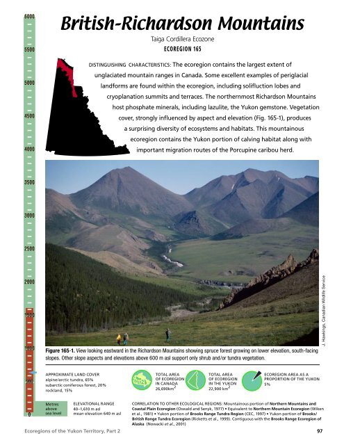
<strong>British–Richardson</strong> <strong>Mountains</strong><br />
Taiga Cordillera Ecozone<br />
Ecoregions of the Yukon Territory, Part 2<br />
<strong>ECOREGION</strong> 165<br />
DISTINGUISHING CHARACTERISTICS: The ecoregion contains the largest extent of<br />
unglaciated mountain ranges in Canada. Some excellent examples of periglacial<br />
landforms are found within the ecoregion, including solifluction lobes and<br />
cryoplanation summits and terraces. The northernmost Richardson <strong>Mountains</strong><br />
host phosphate minerals, including lazulite, the Yukon gemstone. Vegetation<br />
cover, strongly influenced by aspect and elevation (Fig. 165-1), produces<br />
a surprising diversity of ecosystems and habitats. This mountainous<br />
ecoregion contains the Yukon portion of calving habitat along with<br />
important migration routes of the Porcupine caribou herd.<br />
Figure 165-1. View looking eastward in the Richardson <strong>Mountains</strong> showing spruce forest growing on lower elevation, south-facing<br />
slopes. Other slope aspects and elevations above 600 m asl support only shrub and/or tundra vegetation.<br />
APPROXIMATE LAND COVER<br />
alpine/arctic tundra, 65%<br />
subarctic coniferous forest, 20%<br />
rockland, 15%<br />
Metres<br />
above<br />
sea level<br />
ELEVATIONAL RANGE<br />
40–1,610 m asl<br />
mean elevation 640 m asl<br />
TOTAL AREA<br />
OF <strong>ECOREGION</strong><br />
IN CANADA<br />
26,690km 2<br />
TOTAL AREA<br />
OF <strong>ECOREGION</strong><br />
IN THE YUKON<br />
22,900 km 2<br />
<strong>ECOREGION</strong> AREA AS A<br />
PROPORTION OF THE YUKON<br />
5%<br />
CORRELATION TO OTHER ECOLOGICAL REGIONS: Mountainous portion of Northern <strong>Mountains</strong> and<br />
Coastal Plain Ecoregion (Oswald and Senyk, 1977) <strong>•</strong> Equivalent to Northern Mountain Ecoregion (Wiken<br />
et al., 1981) <strong>•</strong> Yukon portion of Brooks Range Tundra Region (CEC, 1997) <strong>•</strong> Yukon portion of Brooks/<br />
British Range Tundra Ecoregion (Ricketts et al., 1999). Contiguous with the Brooks Range Ecoregion of<br />
Alaska (Nowacki et al., 2001)<br />
97<br />
J. Hawkings, Canadian Wildlife Service
<strong>British–Richardson</strong> <strong>Mountains</strong> <strong>•</strong> <strong>ECOREGION</strong> 165<br />
PHYSIOGRAPHY<br />
The British, Barn and Richardson mountains and<br />
intervening valleys compose the <strong>British–Richardson</strong><br />
<strong>Mountains</strong> Ecoregion (Rampton, 1982) (Fig. 2).<br />
They have been sometimes known collectively as<br />
the Arctic <strong>Mountains</strong> or Ranges (Bostock, 1948;<br />
Hughes, 1987b). The British <strong>Mountains</strong> comprise<br />
the eastern extension of the Alaskan Brooks Range,<br />
including the Buckland Hills and the northern<br />
foothills of the British <strong>Mountains</strong> (Rampton, 1982).<br />
The British and Barn mountains run parallel to<br />
the north coast of the Yukon. The Richardson<br />
<strong>Mountains</strong> trend north–south from east of the Barn<br />
<strong>Mountains</strong> south to the Peel River.<br />
The mountains have remained largely unglaciated<br />
except for minor alpine glaciation in the British<br />
<strong>Mountains</strong> and the eastern flank of the Richardson<br />
<strong>Mountains</strong> (Fig. 165-2). The ecoregion is<br />
characterized by steep, V-shaped valleys in the<br />
higher ranges and gently sloping pediments where<br />
the valleys are broader.<br />
The relief in the mountains ranges from 450 to<br />
900 m. The highest elevations are associated with<br />
the western British <strong>Mountains</strong> and the southern<br />
Richardson <strong>Mountains</strong> where there are unnamed<br />
peaks over 1,600 m asl. In the northern Richardson<br />
and Barn mountains, the topography is more<br />
subdued.<br />
The British, Barn and Richardson mountains are<br />
cut by large rivers flowing north to the Beaufort<br />
Sea. From the west, the most significant are the<br />
Malcolm, Firth, Babbage, Blow and Big Fish rivers.<br />
The southern slopes of the mountain ranges are<br />
drained by small tributaries to the Porcupine River.<br />
Most of the Richardson <strong>Mountains</strong> also drain to the<br />
Porcupine via the Bell and tributaries of the Eagle<br />
River. The south and east slopes of the Richardsons<br />
are part of the Peel watershed.<br />
BEDROCK GEOLOGY<br />
This ecoregion contains well-exposed sedimentary<br />
rocks of Proterozoic to Cretaceous age and small<br />
Devonian granite intrusions, and spans three<br />
separate geological structures. The British and Barn<br />
mountains, an eastern continuation of the Alaskan<br />
Brooks Range, are part of the Arctic–Alaska<br />
Terrane, consisting of continental margin sediments<br />
(Wheeler and McFeely, 1991). The topographically<br />
subdued region east of the mountains is the Blow<br />
98<br />
Figure 165-2. A view of the Richardson <strong>Mountains</strong> showing<br />
Laurentide glacial drift in valley bottoms and unglaciated upper<br />
slopes and ridgetops. Note the contrast between light coloured,<br />
lichen-dominated colluvial slopes and valley-bottom drift surfaces<br />
that are vegetated by darker coloured sedge tussock/moss<br />
communities.<br />
Trough, a mid-Cretaceous extension basin. The<br />
south-trending Richardson <strong>Mountains</strong> resulted from<br />
Paleozoic deep-water clastic sediments being uplifted<br />
by outward-verging thrust faults located at an<br />
interpreted westward-dipping crustal ramp (Lane,<br />
1996) in latest Cretaceous or early Tertiary time.<br />
Bedrock geology of the entire ecoregion is shown on<br />
regional maps by Norris (1981a,b,f,g) and described<br />
by various authors in his report (Norris [editor],<br />
1997). Many regional aspects of the stratigraphy<br />
and structure have been studied in detail.<br />
The British and Barn mountains comprise folded<br />
and faulted structural blocks, uplifted in early<br />
Tertiary time, separated by a structural depression<br />
along the Babbage River. The Romanzov Uplift,<br />
Ecoregions of the Yukon Territory, Part 2<br />
J. Meikle, Yukon Government
traversed by the Firth River, exposes a thick<br />
structural succession consisting of the following<br />
units: Proterozoic mixed carbonate and fine clastic<br />
rocks; latest Proterozoic to Cambrian sandstone<br />
— the Neruokpuk Formation, 600–1000 m thick;<br />
Cambrian and Ordovician volcanic and volcanicclastic<br />
rocks with limestone and argillite — the<br />
Whale Mountain succession; and Ordovician to<br />
Devonian black argillite and siltstone — equivalent<br />
to Road River Formation. Most of the succession<br />
is directly correlated with the Proterozoic to mid-<br />
Paleozoic Selwyn Basin of the central Yukon (Lane<br />
and Cecile, 1989; Lane, 1991). Mount Sedgewick<br />
in the British <strong>Mountains</strong> is cored by a biotite<br />
quartz monzonite pluton (370 Ma; Mortensen and<br />
Bell, 1991). The Barn Range is a tectonic uplift of<br />
a structurally thickened succession of dark grey<br />
to black, red, and green shale, ridge-forming grey<br />
quartzite and siltstone, and light grey limestone<br />
(Cecile, 1988; Cecile and Lane, 1991) equivalent to<br />
the upper Hyland group and overlying Road River<br />
Formation. Two hornblende–biotite granites, Mount<br />
Fitton and Hoidahl Dome, have prominent orangeweathering<br />
pyrite haloes. The flanks of these two<br />
uplifts constitute the Endicott and Lisburne groups<br />
of Carboniferous age overlain by Kingak Formation<br />
from the Jurassic–Cretaceous. Blow River Trough<br />
contains 4 to 10 km of Albian flysch, in part the<br />
Rapid Creek Formation (Young, 1975).<br />
The Richardson <strong>Mountains</strong> are divided by a<br />
structural and topographic depression at the head of<br />
the Vittrekwa River at the continental divide on the<br />
Dempster Highway with different structural styles<br />
to north and south. To the north, ridges formed<br />
by differential erosion of more resistant units are<br />
short and offset by faults. The White <strong>Mountains</strong> are<br />
an uplifted block of light-grey Paleozoic limestone,<br />
which produces extremely rugged topography,<br />
surrounded by dark brown clastic sediments<br />
of Ordovician to Devonian age. In contrast, the<br />
southern Richardson <strong>Mountains</strong> are a breached<br />
anticlinorium with sandstone and limestone of<br />
the Slats Creek and Illtyd formations, being Lower<br />
and Middle Cambrian respectively (Fritz, 1996) in<br />
the hinges, flanked by more resistant chert and<br />
limestone of the Road River Formation of Ordovician<br />
to Middle Devonian age. Throughout the Richardson<br />
<strong>Mountains</strong> are long, curved and near-vertical<br />
faults of the Richardson Fault Array. The southern<br />
Richardson <strong>Mountains</strong> remain seismically active<br />
(Forsyth et al., 1996).<br />
Ecoregions of the Yukon Territory, Part 2<br />
<strong>ECOREGION</strong> 165 <strong>•</strong> <strong>British–Richardson</strong> <strong>Mountains</strong><br />
In general the oldest succession of mixed carbonate<br />
and clastic rocks underlies subdued topography<br />
and produces calcareous soil with common<br />
caliche surfaces (L. Lane, pers. comm., 1997). The<br />
blocky talus below thick limestone units, as well<br />
as from Precambrian sandstone units, provides<br />
denning sites for foxes, wolf and bear. Slopes<br />
underlain by the sandstone, as well as Cambro–<br />
Ordovician volcanic and volcaniclastic rocks are<br />
characteristically unstable and lightly vegetated<br />
with blocky talus cones. Cambro–Ordovician<br />
argillite and chert underlies subdued topography<br />
with fine, granular talus that is well vegetated and<br />
suitable habitat for burrowers. Steeply dipping<br />
chert layers locally produce jagged, razor-like ridge<br />
crests. The Carboniferous dark shale of the Kayak<br />
Formation and sandstone locally harbour evaporite<br />
minerals, used as salt licks by caribou, while the<br />
tilted limestone strata erode into rugged topography.<br />
A variety of mineral types are known, although<br />
much of the northern part of the ecoregion was<br />
withdrawn from claim staking in 1978, limiting<br />
further investigations. The Blow River, Rapid Creek<br />
and Big Fish River area contain new phosphate<br />
minerals (Robinson et al., 1992), including lazulite,<br />
the Yukon gemstone. This area also contains very<br />
large phosphatic iron manganese reserves. The<br />
Barn <strong>Mountains</strong> hold uranium in conglomerate of<br />
Carboniferous and Cretaceous Age as well as in<br />
skarns with molybdenum, tungsten and copper<br />
near the Fitton and Sedgewick granitic intrusions.<br />
Minor gold occurs at Mount Sedgewick and at<br />
Whale Mountain. The erosion of Devonian granite<br />
in nearby Alaska has produced the placer deposit<br />
in Sheep Creek, near the Firth River. A magnetite<br />
iron formation occurs locally in the Cambrian to<br />
Devonian units of the Romanzov Uplift near the<br />
Alaska–Yukon border (Lane et al., 1995). Seams of<br />
anthracite are common in the Mississippian Kayak<br />
and Cretaceous Kamik formations throughout<br />
the ecoregion. The Richardson <strong>Mountains</strong> contain<br />
several galena and sphalerite occurrences, typically<br />
in breccia zones within the Illtyd (Pilon showing)<br />
and Road River (Vittrekwa showing) limestones.<br />
Magnetite, minor chalcopyrite and brannerite<br />
occur in a diatreme breccia within Proterozoic lime<br />
siltstone. Large gypsum lenses in the Richardson<br />
Fault Array straddle the Yukon–Northwest<br />
Territories border.<br />
A spectacular exposure of Road River sedimentary<br />
rocks occurs at Canyon Creek, and quartzite of<br />
99
A. Duk-Rodkin, Geological Survey of Canada<br />
<strong>British–Richardson</strong> <strong>Mountains</strong> <strong>•</strong> <strong>ECOREGION</strong> 165<br />
the Jurassic Bug Creek Group provides impressive<br />
cryoplanation terraces in the northern Richardson<br />
<strong>Mountains</strong> (Fig. 27 in Norris [editor], 1997).<br />
SURFICIAL GEOLOGY AND<br />
GEOMORPHOLOGY<br />
This high relief, largely unglaciated terrain has been<br />
affected mostly by mass wasting and weathering.<br />
Rock outcrops are common, being mostly composed<br />
of friable sedimentary rocks such as sandstone,<br />
limestone and shale. At high elevations, tors,<br />
pinnacles and dyke-like ridges stand out at or near<br />
summits. The summits, as well as the uppermost<br />
slopes of mountains, are usually blanketed by<br />
unvegetated rock fragments either as felsenmeer or<br />
colluvium veneer, interspersed with frost-shattered<br />
crags.<br />
Middle and low elevations are covered by residual<br />
or weathered rock, or soliflucted and colluvial<br />
materials, which form fans or long, gentle pediment<br />
slopes. Pediments are extensively developed in this<br />
mountainous ecoregion, with three levels identified<br />
in the Richardson <strong>Mountains</strong> and at least six in<br />
the British <strong>Mountains</strong> (L. Lane, pers. comm., 1997)<br />
(Fig. 165-3). Stone circles and other patterned<br />
grounds are occasionally present.<br />
Most small streams have coarse gravel beds. The<br />
streams are often entrenched in pediment surfaces.<br />
100<br />
Upper slopes have developed intricate, feather-like<br />
drainage patterns. Thin loess deposits are common<br />
throughout the ecoregion.<br />
Modern processes relate dominantly to colluvium<br />
deposits, including a variety of materials<br />
transported by solifluction and sheetwash<br />
(Fig. 165-4). Periglacial features include<br />
cryoplanation terraces found all along the northern<br />
Cordillera, with the highest concentration along the<br />
southern slopes of the British <strong>Mountains</strong> north of<br />
the Old Crow Basin (Lauriol and Godbout, 1988;<br />
Lauriol, 1990).<br />
GLACIAL HISTORY<br />
Localized alpine glaciers affected the highest<br />
mountains during Pleistocene glacial periods of<br />
undetermined ages. There are two restricted areas<br />
where local glaciers developed: at the headwater<br />
of Malcolm River in the British <strong>Mountains</strong><br />
(Duk-Rodkin, in press) and east of Bell River in<br />
an unnamed peak in the Richardson <strong>Mountains</strong><br />
(Duk-Rodkin and Hughes, 1992a). Cirque scars<br />
are found in both these areas, but no glacial<br />
deposits have been recognized in the valleys of the<br />
Richardson <strong>Mountains</strong>. Malcolm Valley has glacial<br />
features that could relate to three glacial periods,<br />
including the Late Wisconsinan. The identification of<br />
these three glacial periods is based on the degree of<br />
preservation of glacial features on these valleys.<br />
Figure 165-3. Pediment terraces<br />
on the eastern slope of the<br />
Richardson <strong>Mountains</strong> have been<br />
partly glaciated by the Laurentide<br />
ice sheet. The tundra vegetation<br />
in the foreground is dominated<br />
by cotton grass (Eriophorum<br />
vaginatum).<br />
Ecoregions of the Yukon Territory, Part 2
Figure 165-4. The mottled<br />
texture of this slope results from<br />
solifluction, the sliding of the<br />
active layer over the underlying<br />
permafrost. The solifluction<br />
lobes, like rolls, are several<br />
metres across and up to 2 m<br />
high. They are composed of<br />
a mix of mineral soil, organic<br />
matter and rock fragments.<br />
During its maximum extent, the Laurentide Ice<br />
Sheet extended up to 970 m asl in the southern<br />
Richardson <strong>Mountains</strong>, descending to 880 m asl<br />
in McDougall Pass. This Late Wisconsinan limit<br />
30,000 years ago (Hughes et al., 1981; Schweger and<br />
Matthews, 1991) is the only glacial limit represented<br />
in this ecoregion. Though the ice sheet crossed<br />
the continental divide in this ecoregion only at<br />
McDougall Pass, meltwater drained to the western<br />
side of the mountains at several sites, including<br />
the headwaters of the Road and Vittrekwa rivers.<br />
This resulted in several changes to pre-existing<br />
drainages, most importantly the westward diversion<br />
of the Porcupine River (Duk-Rodkin and Hughes,<br />
1994) that caused the inundation of the Bell–Old<br />
Crow–Bluefish basins. The outlet of this proglacial<br />
lake cut a canyon to the west, establishing the<br />
Porcupine River as a tributary to the Yukon River.<br />
Today, the former thalweg of the paleo-Porcupine<br />
River in McDougall Pass is buried under 150 m<br />
of glacial drift. Terraces related to the preglacial<br />
drainage are found along both sides of the valley in<br />
McDougall Pass, some of which have been partially<br />
glaciated by the Laurentide Ice Sheet (Duk-Rodkin<br />
and Hughes, 1992a, 1994). The paleo-Porcupine<br />
River was one of the many drainage systems that<br />
were changed by the Laurentide Ice Sheet.<br />
Pediment development has been ongoing since at<br />
least the late Miocene (McNeil et al., 1993; Duk-<br />
Rodkin and Hughes, 1994). Lower pediment<br />
Ecoregions of the Yukon Territory, Part 2<br />
surfaces grade into alluvial fans towards the<br />
interior basins. Pediment surfaces commonly<br />
have a veneer of colluvium derived from local<br />
bedrock. Extensive pediment areas are found along<br />
the eastern and western slopes of Richardson<br />
<strong>Mountains</strong> (Duk-Rodkin and Hughes, 1992a,b).<br />
However, pediments along the eastern side of the<br />
mountains were covered by the Laurentide Ice Sheet<br />
(Fig. 165-3). On the deep glacial drift in McDougall<br />
Pass, the dominant surface units are morainal<br />
blankets, hummocky moraine and lacustrine<br />
deposits.<br />
CLIMATE<br />
<strong>ECOREGION</strong> 165 <strong>•</strong> <strong>British–Richardson</strong> <strong>Mountains</strong><br />
<strong>Mountains</strong> in this ecoregion are oriented<br />
southeastward through the northern Yukon and<br />
then southward to the Peel River valley. Although<br />
not massive, with elevations from 500 to 1,600 m<br />
asl, these mountains are rugged and have<br />
significant climatic effects. The higher elevations<br />
have less extreme temperatures, but greater<br />
precipitation and wind velocity, than in surrounding<br />
terrain. Winds are stronger over higher elevations,<br />
but particularly significant is the funneling effect<br />
of the valleys. There are frequent occurrences of<br />
strong to gale-force winds that can develop through<br />
depressions when masses of cold Arctic air either<br />
spill into or out of the Yukon’s interior during the<br />
winter. Due to the latitude, the sun remains above<br />
J. Meikle, Yukon Government<br />
101
<strong>British–Richardson</strong> <strong>Mountains</strong> <strong>•</strong> <strong>ECOREGION</strong> 165<br />
the horizon from early June to mid-July, and below<br />
the horizon from early December to early January.<br />
Mean annual temperatures are near –7.5°C. Mean<br />
January temperatures are –20 to –25°C, but near<br />
–5°C temperatures are not uncommon. Equally<br />
frequent are temperatures near –40°C, particularly<br />
in the lower valley floors. Spring or summer<br />
conditions are generally delayed until early June.<br />
Mean temperatures are near 10°C in July, but again<br />
with variations from near freezing to 25°C.<br />
Precipitation is relatively moderate ranging from 250<br />
to 400 mm annually with the heaviest precipitation<br />
from June through August over the Richardson<br />
<strong>Mountains</strong>. Precipitation remains moderate through<br />
to December, primarily as snow from September<br />
onwards.<br />
Winds are believed to be moderate, but during<br />
the winter can often be strong to gale force. The<br />
prime directions are west and east, but these<br />
can be strongly influenced by local topography.<br />
Active systems moving over the Beaufort Sea can<br />
result in strong outflows of cold Arctic air spilling<br />
through depressions such as the Blow and Babbage<br />
rivers. These winds can result in extensive snow<br />
redistribution.<br />
Little long-term weather data are available from<br />
within the mountains but inferences can be made<br />
from such stations as Old Crow, Eagle Plains, Fort<br />
McPherson, Shingle Point and Komakuk Beach.<br />
Interesting data are becoming available from an<br />
automatic weather station at Rock Creek, near<br />
Wright Pass north of Eagle Plains. The wind data<br />
may be indicative of conditions in other passes.<br />
HYDROLOGY<br />
The northern watersheds of the ecoregion fall largely<br />
within the Arctic Hydrologic Region, while the<br />
southern Richardson <strong>Mountains</strong> watersheds extend<br />
down into the Northern Hydrologic Region. The area<br />
of waterbodies is relatively small; there are few large<br />
lakes within the ecoregion and wetland coverage is<br />
limited in this unglaciated landscape.<br />
Because of the elongated nature of the ecoregion,<br />
hydrologic response is somewhat variable. The<br />
majority of the ecoregion is located north of 68°N<br />
and exhibits a relatively uniform response. The<br />
Richardson “panhandle,” which extends to below<br />
66°N, extends into a region of higher precipitation.<br />
102<br />
There are two representative hydrometric stations<br />
within the Yukon portion of the ecoregion: Firth<br />
and Babbage rivers, though the Eagle River is on<br />
the periphery and is somewhat representative of<br />
the southern portion of the ecoregion. In addition,<br />
three hydrometric stations are adjacent to the<br />
ecoregion in Alaska: Kaparuk and Sagavanirktok<br />
rivers and the Sagavanirktok River tributary.<br />
Annual streamflow is generally characterized by a<br />
gradual increase in discharge in the spring, rising<br />
to a peak in May or June due to snowmelt inputs.<br />
Peak flows tend to be consistently earlier within the<br />
southern portion, and later with a more variable<br />
timing in the north. This ecoregion has among the<br />
highest peak flows and lowest winter low flows in<br />
the Yukon. Many of the first- and second-order<br />
headwater streams are steep and relatively short;<br />
therefore, streamflow response tends to be rapid and<br />
flashy. On these smaller streams, approximately<br />
40% of the annual maximum flows are due to<br />
intense summer rainstorm events. Some small steep<br />
streams are susceptible to mud flows triggered by<br />
these summer rainstorms. Mean annual runoff is<br />
moderate ranging from 150 to 280 mm, with an<br />
ecosystem average of 208 mm. Mean seasonal and<br />
summer flows are likewise moderate with values of<br />
15.8 X 10 –3 and 11.4 X 10 –3 m3 /s/km2 , respectively.<br />
The mean annual flood is relatively high with a<br />
value of 128 X 10 –3 m3 /s/km2 , while the mean<br />
maximum summer flow is more moderate with a<br />
value of 35 X 10 –3 m3 /s/km2 . Minimum streamflow<br />
generally occurs during January or February in<br />
the southern portion of the ecoregion and earlier in<br />
the northern portion. The mean annual minimum<br />
flow ranges from zero in the northern portion to<br />
0.04 X 10 –3 m3 /s/km2 in the southern portion.<br />
Mean summer minimum flow within the ecoregion<br />
is 1.9 X 10 –3 m3 /s/km2 . Most streams experience<br />
zero winter flow.<br />
PERMAFROST<br />
Permafrost is continuous in the <strong>British–Richardson</strong><br />
<strong>Mountains</strong> Ecoregion of the northern Yukon (Harris,<br />
1986) (Fig. 21). Most of the ecoregion was not<br />
glaciated during the Quaternary period, so there are<br />
terrain features produced by over 2 million years<br />
of frost action. The ecoregion is accessible along<br />
the Dempster Highway, from which aprons of frostshattered<br />
debris, extensive networks of patterned<br />
ground, and numerous solifluction lobes are visible<br />
on the mountainsides (Fig. 165-4). The land grading<br />
Ecoregions of the Yukon Territory, Part 2
down from the Barn <strong>Mountains</strong> towards the Yukon<br />
Coastal Plain Ecoregion forms extensive pediments<br />
of gentle gradient (French and Harry, 1992).<br />
Similarly, high elevations within the Richardson<br />
<strong>Mountains</strong> have well-developed sequences of up<br />
to 15 cryoplanation terraces (Lauriol, 1990) — flat<br />
surfaces separated by short, steep rock walls, which<br />
have formed after long-term frost weathering of host<br />
material (Rampton, 1982).<br />
The near-surface permafrost layers are often icerich,<br />
even in bedrock (EBA, 1985). Ice-rich ground<br />
has been detected at depths over 5 m by groundprobing<br />
radar along the Dempster Highway near<br />
the Yukon–Northwest Territories border (EBA,<br />
1987a). Many features characteristic of continuous<br />
permafrost, such as ice wedges, may be found<br />
beneath the regolith, but soil movement down slope<br />
may mask their surface expression. Thaw slumps<br />
are occasionally seen in riverbanks where recent<br />
erosion has exposed ground ice.<br />
Several of the rivers and creeks draining the<br />
ecoregion are fed by perennial springs, and<br />
extensive ice develops in the channel beds each<br />
winter. The largest aufeis, in the Firth River, is<br />
visible on satellite images taken well into summer<br />
(Lauriol et al., 1991). This ice may be several metres<br />
thick and extend over 25 km 2 .<br />
There are no published determinations of permafrost<br />
thickness in this ecoregion, but data from<br />
neighbouring areas suggest depths of 200 to 300 m<br />
(Burgess et al., 1982). The active layer is usually<br />
less than 0.5 m deep on pediments and lower slopes,<br />
but Rampton (1982) reports a thickness of 2.5 m at<br />
favourable well-drained upland sites.<br />
SOILS<br />
Soils in this ecoregion have formed under the<br />
influence of a subarctic climate, strong local relief<br />
and varied geologic parent materials. They are<br />
formed on mountainside colluvium slope deposits<br />
or on the large pediment surfaces of broad valleys.<br />
The near-surface permafrost is nearly continuous,<br />
except for localized occurrences of unfrozen ground<br />
along alluvial systems, glacio-fluvial terraces and<br />
some well-drained south-facing slope deposits.<br />
The soil–landscape relationships in this ecoregion<br />
have been described by Wiken et al. (1981) and<br />
more recently by Welch and Smith (1990) and<br />
are summarized in Figure 165-5. Well-developed<br />
Ecoregions of the Yukon Territory, Part 2<br />
<strong>ECOREGION</strong> 165 <strong>•</strong> <strong>British–Richardson</strong> <strong>Mountains</strong><br />
periglacial landforms exist, including cryoplanation<br />
terraces and cryopediment slopes (French and<br />
Harry, 1992). Soils have formed in nonglacial parent<br />
materials except for those on the eastern flank of<br />
the Richardson <strong>Mountains</strong>, which were subjected to<br />
Laurentide glaciations during the Pleistocene.<br />
All gently sloping surfaces tend to have soil<br />
development strongly influenced by cryoturbation.<br />
These Cryosols are often silty or clay-textured,<br />
saturated for most of the growing season, and<br />
classified as Gleysolic Turbic Cryosols. These soils<br />
tend to be acidic, particularly in association with<br />
shale bedrock; are high in organic matter and<br />
silt, and have active layers of less than 50 cm (see<br />
site 9, Tarnocai et al., 1993). On pediment surfaces,<br />
these soils are associated with tussock tundra<br />
vegetation. Shallow soils over bedrock on upland<br />
surfaces above treeline exhibit a variety of patterned<br />
ground formations, mostly sorted and non-sorted<br />
nets and stripes, tend to be less saturated, and are<br />
classified as Orthic Turbic Cryosols. On mountain<br />
slopes below treeline where there is no near-surface<br />
permafrost, soils are most often classified as Eutric<br />
Brunisols, or occasionally as Melanic Brunisols<br />
if they have thick surface A horizons. Soils are<br />
classified as Orthic Turbic Cryosols wherever<br />
permafrost occurs on steep slopes (Fig. 165-6).<br />
Alluvial sands and gravels tend to lack strong<br />
cryoturbation features or a near-surface permafrost<br />
table, and are classified as Orthic or Humic<br />
Regosols. On older, more stable alluvial surfaces<br />
where permafrost is established, soils are typically<br />
classified as Regosolic Static Cryosols. On welldrained<br />
fluvial terraces, near-surface permafrost<br />
may be lacking and soils are classified as Orthic<br />
Eutric Brunisols.<br />
One of the unique soil features of the ecoregion<br />
is the humus-rich, rendzina-like soil of the<br />
limestone areas of the British <strong>Mountains</strong> (Welch<br />
and Smith, 1990; Smith et al., 1990,). Others<br />
are the cryoplanation terraces and summits of<br />
the Richardson <strong>Mountains</strong> with their associated<br />
patterned ground formations, unique soil fauna<br />
populations (Tynen et al., 1991), and solifluction<br />
lobes (see site 7 in Tarnocai et al., 1993).<br />
103
<strong>British–Richardson</strong> <strong>Mountains</strong> <strong>•</strong> <strong>ECOREGION</strong> 165<br />
<br />
<br />
<br />
<br />
<br />
<br />
<br />
<br />
<br />
<br />
<br />
<br />
<br />
<br />
<br />
<br />
<br />
<br />
<br />
<br />
<br />
<br />
<br />
<br />
<br />
<br />
<br />
<br />
<br />
<br />
<br />
<br />
<br />
<br />
Figure 165-5. Cross-section of soil and vegetation relationships in the Firth River valley in the British <strong>Mountains</strong> portion of the ecoregion.<br />
104<br />
<br />
<br />
<br />
<br />
<br />
<br />
<br />
<br />
<br />
<br />
<br />
<br />
<br />
<br />
<br />
<br />
<br />
<br />
<br />
<br />
<br />
<br />
<br />
<br />
<br />
<br />
<br />
<br />
<br />
<br />
<br />
<br />
<br />
<br />
<br />
<br />
<br />
<br />
<br />
<br />
<br />
<br />
<br />
<br />
<br />
<br />
<br />
<br />
<br />
<br />
<br />
<br />
<br />
<br />
<br />
<br />
<br />
<br />
<br />
<br />
<br />
<br />
<br />
<br />
<br />
Ecoregions of the Yukon Territory, Part 2
VEGETATION<br />
The vegetation of the <strong>British–Richardson</strong> <strong>Mountains</strong><br />
Ecoregion is dominated by shrub tundra. Treeline<br />
ranges from around 600 m asl in the south to<br />
300 m asl in the north (Zoltai and Pettapiece, 1973;<br />
Ritchie, 1984; Loewen and Staniforth, 1997b). Ridge<br />
crests support dwarf willow or dryas–lichen tundra,<br />
often with sparse vegetation cover. Upper and middle<br />
slopes are covered by dry to moist, low shrub and<br />
heath tundra, while on lower slopes sedge tussock<br />
communities predominate. Shrub thickets are<br />
typical along creeks and drainage channels. Trees<br />
are limited to river valleys such as the Firth, Big<br />
Fish, Bell, and lower slopes with favourable aspects<br />
(Fig. 165-1).<br />
On mountain and ridge crests, ranging from 330<br />
to 1,600 m asl, the vegetation is dependent on the<br />
parent material. Because most of the area was<br />
not glaciated, the soil and vegetation communities<br />
reflect the underlying bedrock. Shrub willow (Salix<br />
phlebophylla) is the dominant cover on shale and<br />
sandstone. A sparse cover of S. phlebophylla, arctic<br />
bearberry, dryas, locoweed, and shrub birch often<br />
occurs on only 10 to 20% of the ground surface<br />
(Ritchie, 1984; Loewen and Staniforth, 1997b).<br />
On calcareous parent material (more extensive to<br />
the west in the British <strong>Mountains</strong>), a floristically<br />
rich, although very sparse, dryas–sedge alpine<br />
community with numerous forbs, including moss<br />
Ecoregions of the Yukon Territory, Part 2<br />
<strong>ECOREGION</strong> 165 <strong>•</strong> <strong>British–Richardson</strong> <strong>Mountains</strong><br />
campion, northern sweet-vetch and anemone, and<br />
ground shrubs is more typical (Ritchie, 1984).<br />
Slopes contain a mix of shrub and heath tundra.<br />
On moister snow accumulation sites and solifluction<br />
slopes, willow and ericaceous shrubs including<br />
mountain heather, blueberry, lingonberry, mosses<br />
and forbs are common. Slopes are often unstable<br />
in permafrost areas and many are characterized<br />
by scattered flows or slides. These create numerous<br />
microsites and intricate complexes of dry to moist<br />
vegetation communities. The scarps usually have<br />
dry, low shrubs, while the depressions below are<br />
wet, colonized first by moss, and then quite rapidly<br />
by shrubs. Earth hummocks also create diverse<br />
microsites. In the numerous drainages that transect<br />
the slopes, tall to medium willow grows with<br />
some shrub birch and alder, commonly with an<br />
understory of stepmoss, horsetail, forbs and grass<br />
(Kennedy, 1990).<br />
On the gentle pediment surfaces of lower slopes,<br />
sedge tussock communities predominate.<br />
Cottongrass (Eriophorum vaginatum) is the major<br />
tussock-forming species associated with sedge<br />
(Carex lugens), shrub birch, Labrador tea, blueberry,<br />
lingonberry and mosses dominated by Aulacomnium,<br />
Tomenthypnum and Hylocomium.<br />
Major river valleys provide lower elevation sheltered<br />
environments and deeper active layers, which can<br />
support open stands of white spruce on inactive<br />
Figure 165-6. Cross-section<br />
of typical soil formation on<br />
steep slopes, Richardson<br />
<strong>Mountains</strong>. Soils typically have<br />
dark-coloured, humus-rich<br />
surface horizons (Hy and Ahy).<br />
These horizons are mixed with<br />
rock fragments as a result of<br />
solifluction and cryoturbation.<br />
These overlie a mineral horizon<br />
(C) of weathered bedrock (from<br />
Smith et al., 1990).<br />
105
<strong>British–Richardson</strong> <strong>Mountains</strong> <strong>•</strong> <strong>ECOREGION</strong> 165<br />
river terraces and on well-drained slopes above<br />
the streams (Kennedy, 1990). Tamarack is found<br />
at treeline in the Richardson <strong>Mountains</strong> with<br />
white spruce on moist calcareous substrate.<br />
Balsam poplar is found along recent floodplains<br />
and is probably successional to white spruce if left<br />
undisturbed. Willow, and sometimes alder, thickets<br />
are associated with permafrost-free Regosolic soils<br />
on recent floodplains. Horsetails and annual herbs<br />
are found on the most frequently flooded sites beside<br />
the rivers (Welch and Smith 1990).<br />
WILDLIFE<br />
Mammals<br />
This mountainous region is the primary Canadian<br />
calving area of the Porcupine barren-ground caribou<br />
herd (Fancy et al., 1994). Caribou use the mountain<br />
ridges to maximize wind exposure and gain relief<br />
from biting insects in summer. The ecoregion is<br />
also used for spring and fall migrations and winter<br />
range by the herd. Dall sheep reach their northern<br />
limit of distribution in the British <strong>Mountains</strong> near<br />
the Alaska border and in the Richardson <strong>Mountains</strong><br />
near the Northwest Territories border (Barichello<br />
et al., 1989a). Most moose are seasonal residents of<br />
riparian habitats, migrating below treeline on the<br />
south slope of the mountains in winter (Smits, 1991).<br />
Grizzly bears reach their highest density north<br />
of the Mackenzie <strong>Mountains</strong> here. Wolverines are<br />
abundant and heavily dependent on caribou, which<br />
they opportunistically cache for future use. River<br />
otters are present along fish-bearing streams.<br />
Singing Vole colonies and Varying Lemming are<br />
common. A list of mammal species known or<br />
expected to occur in this ecoregion is given in<br />
Table 4.<br />
106<br />
Birds<br />
The Surfbird is a significant breeder in these rocky<br />
slopes and ridges, as its Canadian distribution<br />
is limited to these mountains and the Ogilvie<br />
<strong>Mountains</strong> (Frisch, 1987). The mostly barren<br />
uplands are utilized in summer by nesting Baird’s<br />
Sandpipers, Hoary Redpolls, Horned Larks,<br />
Northern Wheatears and Gray-crowned Rosy Finch<br />
(Frisch, 1975, 1987; Godfrey, 1986).<br />
Sedge tussock tundra provides habitat for many<br />
species such as Rock Ptarmigan, American Golden-<br />
Plover, Whimbrel, Long-tailed Jaeger and American<br />
Pipit (Frisch, 1975, 1987; Weerstra, 1997). Shrubby<br />
tundra at these and lower elevations is inhabited by<br />
Willow Ptarmigan, Northern Shrike, American Tree,<br />
Savannah and White-crowned Sparrows, Smith’s<br />
Longspur and Common Redpoll (Godfrey, 1986;<br />
Frisch, 1987; Weerstra, 1997). Upland Sandpipers<br />
breed in sparsely treed, subalpine bogs (Frisch,<br />
1987).<br />
Scattered forests provide breeding habitat for Gray<br />
Jay, Townsend’s Solitaire, Gray-cheeked Thrush,<br />
American Robin, Yellow-rumped Warbler and Fox<br />
Sparrow (Frisch, 1987; Weerstra, 1997). The rare<br />
Gray-headed Chickadee is occasionally found in<br />
this sparsely treed habitat, while the omnipresent<br />
Common Raven occurs throughout (Frisch, 1987;<br />
Sinclair et al. [editors], 2003).<br />
Cliffs, banks, and canyon walls of the Firth River<br />
provide breeding sites for Rough-legged Hawk,<br />
Golden Eagle, Peregrine Falcon, Gyrfalcon and Say’s<br />
Phoebe (Theberge et al. [editors], 1979; CWS, Birds<br />
of the Yukon Database). Harlequin Ducks occur in<br />
summer on swift flowing streams and smaller rivers<br />
(Frisch, 1987). Wandering Tattlers nest along gravel<br />
bars of mountain streams (Godfrey, 1986). Dense<br />
willow and alder along many of these watercourses<br />
provide habitat for breeding Yellow and Wilson’s<br />
Warblers (Frisch, 1987). Tundra ponds provide<br />
breeding habitat for Red-throated Loon, Tundra<br />
Swan, Northern Pintail, Long-tailed Duck and Rednecked<br />
Phalarope (Frisch, 1987). Ferns and shallow<br />
water ponds provide breeding habitat for Northern<br />
Harrier, Least Sandpiper and Common Snipe<br />
(Frisch, 1987).<br />
Ecoregions of the Yukon Territory, Part 2