British–Richardson Mountains • ECOREGION
British–Richardson Mountains • ECOREGION
British–Richardson Mountains • ECOREGION

Create successful ePaper yourself
Turn your PDF publications into a flip-book with our unique Google optimized e-Paper software.
<strong>British–Richardson</strong> <strong>Mountains</strong> <strong>•</strong> <strong>ECOREGION</strong> 165<br />
PHYSIOGRAPHY<br />
The British, Barn and Richardson mountains and<br />
intervening valleys compose the <strong>British–Richardson</strong><br />
<strong>Mountains</strong> Ecoregion (Rampton, 1982) (Fig. 2).<br />
They have been sometimes known collectively as<br />
the Arctic <strong>Mountains</strong> or Ranges (Bostock, 1948;<br />
Hughes, 1987b). The British <strong>Mountains</strong> comprise<br />
the eastern extension of the Alaskan Brooks Range,<br />
including the Buckland Hills and the northern<br />
foothills of the British <strong>Mountains</strong> (Rampton, 1982).<br />
The British and Barn mountains run parallel to<br />
the north coast of the Yukon. The Richardson<br />
<strong>Mountains</strong> trend north–south from east of the Barn<br />
<strong>Mountains</strong> south to the Peel River.<br />
The mountains have remained largely unglaciated<br />
except for minor alpine glaciation in the British<br />
<strong>Mountains</strong> and the eastern flank of the Richardson<br />
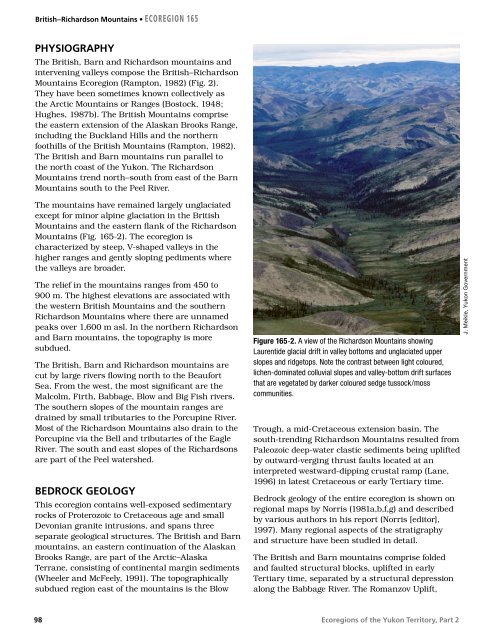
<strong>Mountains</strong> (Fig. 165-2). The ecoregion is<br />
characterized by steep, V-shaped valleys in the<br />
higher ranges and gently sloping pediments where<br />
the valleys are broader.<br />
The relief in the mountains ranges from 450 to<br />
900 m. The highest elevations are associated with<br />
the western British <strong>Mountains</strong> and the southern<br />
Richardson <strong>Mountains</strong> where there are unnamed<br />
peaks over 1,600 m asl. In the northern Richardson<br />
and Barn mountains, the topography is more<br />
subdued.<br />
The British, Barn and Richardson mountains are<br />
cut by large rivers flowing north to the Beaufort<br />
Sea. From the west, the most significant are the<br />
Malcolm, Firth, Babbage, Blow and Big Fish rivers.<br />
The southern slopes of the mountain ranges are<br />
drained by small tributaries to the Porcupine River.<br />
Most of the Richardson <strong>Mountains</strong> also drain to the<br />
Porcupine via the Bell and tributaries of the Eagle<br />
River. The south and east slopes of the Richardsons<br />
are part of the Peel watershed.<br />
BEDROCK GEOLOGY<br />
This ecoregion contains well-exposed sedimentary<br />
rocks of Proterozoic to Cretaceous age and small<br />
Devonian granite intrusions, and spans three<br />
separate geological structures. The British and Barn<br />
mountains, an eastern continuation of the Alaskan<br />
Brooks Range, are part of the Arctic–Alaska<br />
Terrane, consisting of continental margin sediments<br />
(Wheeler and McFeely, 1991). The topographically<br />
subdued region east of the mountains is the Blow<br />
98<br />
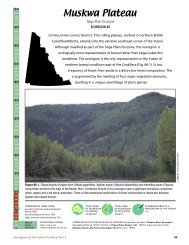
Figure 165-2. A view of the Richardson <strong>Mountains</strong> showing<br />
Laurentide glacial drift in valley bottoms and unglaciated upper<br />
slopes and ridgetops. Note the contrast between light coloured,<br />
lichen-dominated colluvial slopes and valley-bottom drift surfaces<br />
that are vegetated by darker coloured sedge tussock/moss<br />
communities.<br />
Trough, a mid-Cretaceous extension basin. The<br />
south-trending Richardson <strong>Mountains</strong> resulted from<br />
Paleozoic deep-water clastic sediments being uplifted<br />
by outward-verging thrust faults located at an<br />
interpreted westward-dipping crustal ramp (Lane,<br />
1996) in latest Cretaceous or early Tertiary time.<br />
Bedrock geology of the entire ecoregion is shown on<br />
regional maps by Norris (1981a,b,f,g) and described<br />
by various authors in his report (Norris [editor],<br />
1997). Many regional aspects of the stratigraphy<br />
and structure have been studied in detail.<br />
The British and Barn mountains comprise folded<br />
and faulted structural blocks, uplifted in early<br />
Tertiary time, separated by a structural depression<br />
along the Babbage River. The Romanzov Uplift,<br />
Ecoregions of the Yukon Territory, Part 2<br />
J. Meikle, Yukon Government