British–Richardson Mountains • ECOREGION
British–Richardson Mountains • ECOREGION
British–Richardson Mountains • ECOREGION

Create successful ePaper yourself
Turn your PDF publications into a flip-book with our unique Google optimized e-Paper software.
A. Duk-Rodkin, Geological Survey of Canada<br />
<strong>British–Richardson</strong> <strong>Mountains</strong> <strong>•</strong> <strong>ECOREGION</strong> 165<br />
the Jurassic Bug Creek Group provides impressive<br />
cryoplanation terraces in the northern Richardson<br />
<strong>Mountains</strong> (Fig. 27 in Norris [editor], 1997).<br />
SURFICIAL GEOLOGY AND<br />
GEOMORPHOLOGY<br />
This high relief, largely unglaciated terrain has been<br />
affected mostly by mass wasting and weathering.<br />
Rock outcrops are common, being mostly composed<br />
of friable sedimentary rocks such as sandstone,<br />
limestone and shale. At high elevations, tors,<br />
pinnacles and dyke-like ridges stand out at or near<br />
summits. The summits, as well as the uppermost<br />
slopes of mountains, are usually blanketed by<br />
unvegetated rock fragments either as felsenmeer or<br />
colluvium veneer, interspersed with frost-shattered<br />
crags.<br />
Middle and low elevations are covered by residual<br />
or weathered rock, or soliflucted and colluvial<br />
materials, which form fans or long, gentle pediment<br />
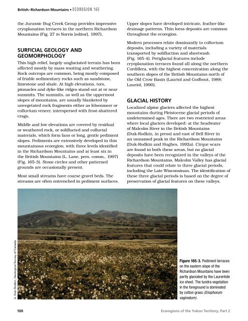
slopes. Pediments are extensively developed in this<br />
mountainous ecoregion, with three levels identified<br />
in the Richardson <strong>Mountains</strong> and at least six in<br />
the British <strong>Mountains</strong> (L. Lane, pers. comm., 1997)<br />
(Fig. 165-3). Stone circles and other patterned<br />
grounds are occasionally present.<br />
Most small streams have coarse gravel beds. The<br />
streams are often entrenched in pediment surfaces.<br />
100<br />
Upper slopes have developed intricate, feather-like<br />
drainage patterns. Thin loess deposits are common<br />
throughout the ecoregion.<br />
Modern processes relate dominantly to colluvium<br />
deposits, including a variety of materials<br />
transported by solifluction and sheetwash<br />
(Fig. 165-4). Periglacial features include<br />
cryoplanation terraces found all along the northern<br />
Cordillera, with the highest concentration along the<br />
southern slopes of the British <strong>Mountains</strong> north of<br />
the Old Crow Basin (Lauriol and Godbout, 1988;<br />
Lauriol, 1990).<br />
GLACIAL HISTORY<br />
Localized alpine glaciers affected the highest<br />
mountains during Pleistocene glacial periods of<br />
undetermined ages. There are two restricted areas<br />
where local glaciers developed: at the headwater<br />
of Malcolm River in the British <strong>Mountains</strong><br />
(Duk-Rodkin, in press) and east of Bell River in<br />
an unnamed peak in the Richardson <strong>Mountains</strong><br />
(Duk-Rodkin and Hughes, 1992a). Cirque scars<br />
are found in both these areas, but no glacial<br />
deposits have been recognized in the valleys of the<br />
Richardson <strong>Mountains</strong>. Malcolm Valley has glacial<br />
features that could relate to three glacial periods,<br />
including the Late Wisconsinan. The identification of<br />
these three glacial periods is based on the degree of<br />
preservation of glacial features on these valleys.<br />
Figure 165-3. Pediment terraces<br />
on the eastern slope of the<br />
Richardson <strong>Mountains</strong> have been<br />
partly glaciated by the Laurentide<br />
ice sheet. The tundra vegetation<br />
in the foreground is dominated<br />
by cotton grass (Eriophorum<br />
vaginatum).<br />
Ecoregions of the Yukon Territory, Part 2