Common Ground - Western Reserve Land Conservancy
Common Ground - Western Reserve Land Conservancy
Common Ground - Western Reserve Land Conservancy

Create successful ePaper yourself
Turn your PDF publications into a flip-book with our unique Google optimized e-Paper software.
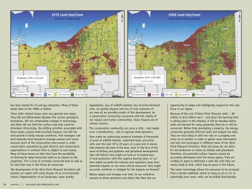
Population 1970: 4,219,345<br />
Source: U.S. Census<br />
has been leased for oil and gas extraction. Many of these<br />
leases date to the 1980s or before.<br />
These older mineral leases were very general and vague.<br />
They did not differentiate between the various geological<br />
formations, did not contemplate changes in technology,<br />
and often did not limit the surface area that could be<br />
disturbed. Historically, the drilling activities associated with<br />
these leases caused small localized impacts, but left the<br />
land around in fairly natural conditions. Park managers and<br />
land stewards have learned to manage around such issues<br />
because much of the conservation land owned or under<br />
conservation easements by park districts and conservation<br />
organizations in northern Ohio is subject to such leases.<br />
Many of these leases on their face have the possibility<br />
of allowing for deep horizontal wells to be placed on the<br />
properties. This is true of currently conserved land as well as<br />
for land that may in the future be conserved.<br />
The development of the Utica Point Pleasant formation will<br />
present our region with many threats of an environmental<br />
nature. Fragmentation of our landscape, water quality<br />
50 CHAPTER 5 CHALLENGES AND OPPORTUNITIES LOOM<br />
1976 <strong>Land</strong> Use/Cover<br />
Source: U.S. Geological Survey<br />
Population 2010: 3,957,883<br />
Source: U.S. Census<br />
degradation, loss of wildlife habitat, loss of prime farmland<br />
soils, air quality impacts and loss of rural character of<br />
our area all are possible results of this development. As<br />
a conservation community concerned with the vitality of<br />
our natural and human communities, these impacts are of<br />
utmost concern.<br />
The conservation community can serve a vital – and maybe<br />
even a transforming – role in regional shale dynamics.<br />
How might we collectively preserve hundreds of thousands<br />
of acres of wildlife habitat, watershed lands and prime<br />
soils over the next 10 to 20 years at a pace and in places<br />
that protects the best of the best, even in the face of the<br />
wave of drilling and pipelines and peripheral development<br />
that will follow? How might we fund an increased pace<br />
of land protection with this urgency bearing down on us?<br />
How might we guide the industry and regulators away from<br />
potential impacts on our most critical resources? How might<br />
we avoid, minimize or mitigate for the impacts we foresee?<br />
Nature adapts and changes over time. In our collective<br />
answers to these questions and others like them lies our<br />
2006 <strong>Land</strong> Use/Cover<br />
Source: National <strong>Land</strong> Cover Database<br />
County Boundaries Developed Water Agricultural Use Natural Areas<br />
County Boundaries<br />
Developed Open Water Agricultural Use Natural Areas<br />
opportunity to adapt and intelligently respond to this new<br />
force in our region.<br />
Because of the cost of Utica Point Pleasant wells -- $6<br />
million to $12 million each – and given the learning that<br />
is taking place in the industry, it will be decades before<br />
wells are planned for many properties that are or will be<br />
conserved. Before fully developing a property, the energy<br />
companies generally drill test wells and analyze the data.<br />
They are most likely to drill one well on a property and<br />
move on to another in order to gather more information<br />
and test new techniques in different areas of the Utica<br />
Point Pleasant formation. Most old leases do not allow<br />
for the landowner or others to dictate well placement.<br />
Therefore, the potential surface impacts cannot be<br />
accurately delineated until the lessee agrees. They are<br />
unlikely to agree to delineate a well site until they are<br />
nearly ready to drill, which may be years in the future.<br />
The newer technology allows the resources to be accessed<br />
from a remote wellhead, where as many as six to 12, or<br />
potentially even more, wells can be drilled directionally